· web viewseveral funnel clouds were reported near the outagamie county airport by a pilot, and...
TRANSCRIPT

AUGUST TORNADO GUIDE (1950-2014)FOR NORTH CENTRAL AND NORTHEAST WISCONSIN
1

AUGUST TORNADO GUIDE (1950-2014)FOR NORTH CENTRAL AND NORTHEAST WISCONSIN
2

AUGUST TORNADO GUIDE (1950-2014)FOR NORTH CENTRAL AND NORTHEAST WISCONSIN
AUGUST
BROWN MENOMINEE
CALUMET OCONTO
DOOR ONEIDA
FOREST OUTAGAMIE
FLORENCE PORTAGE
KEWAUNEE SHAWANO
LANGLADE VILAS
LINCOLN WAUPACA
MANITOWOC WAUSHARA
MARATHON WINNEBAGO
MARINETTE WOOD
3
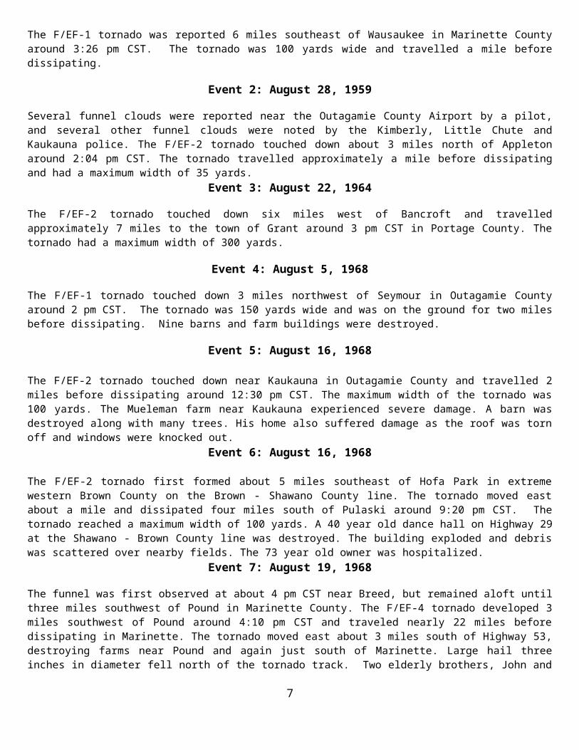
AUGUST TORNADO REFERENCE GUIDEGREEN BAY FORECAST AREA TORNADOES
EVENT F / EF DATE TIME TOR IN GRB SERVICE AREA# RANK MONTH DAY YEAR (LST) DIRECTION / LOCATION COUNTY OR COUNTIES
1 1 8 30 1958 1526 6 SE Wausaukee Marinette
2 2 8 28 1959 1404 3 N Appleton Outagamie
3 2 8 22 1964 1400 6 W Bancroft - Grant Portage
4 1 8 5 1968 1400 3 NW Seymour Outagamie
5 2 8 16 1968 1230 Kaukauna Outagamie
6 2 8 16 1968 2120 5 SE Hofa Park - 4 S Pulaski Brown
7 4 8 19 1968 1610 3 SW Pound - Marinette Marinette
8 2 8 19 1968 1730 4 W Fenwood - 11 E Fenwood Marathon
9 1 8 21 1972 1510 Goodwin - Two Rivers Manitowoc
10 3 8 31 1977 1815 1 SW Stratford - Wausau Marathon
11 1 8 4 1979 1000 Manitowoc Manitowoc
12 2 8 9 1979 1820 Rockland Beach Calumet
13 1 8 9 1979 1856 Green Bay - northeast Brown
14 2 8 12 1985 1813-1830 6 S Marshfield - Auburndale Wood
15 0 8 12 1985 1930-1945 1 N Richford Waushara
16 1 8 14 1987 1740-1743 1 W Menasha Winnebago
17 1 8 1 1988 1852 1 W Saint Germain Vilas
18 0 8 1 1988 1820 3 S Hazelhurst Oneida
19 0 8 1 1988 1922 2 SE Eagle River Vilas
20 1 8 4 1988 1435-1445 1 E Reedsville - 2 N Cato Manitowoc
21 3 8 29 1992 1910-1955 1 N Wautoma - 3 SE Poysippi Waushara
22 0 8 9 1993 2015 1 N Tripoli Oneida
23 1 8 27 1994 2107 Hancock Waushara
24 1 8 27 1994 2141-2150 1.5 S Wausaukee - 3 SE Wausaukee Marinette
25 2 8 7 1996 0145-0149 6.5 N Stratford - 2.5 NNW Fernwood Marathon
26 1 8 7 1996 0146-0147 1 N - 1.2 NE Stratford Marathon
277 1 8 7 1996 0219-0221 0.4 SW Shantytown - Shantytown Marathon
28 0 8 23 1998 1522 Menasha Winnebago
29 3 8 23 1998 1730-1744 3 SW Egg Harbor - 5 SE Egg Harbor Door
30 0 8 3 1999 1745 3 W Pittsville Wood
31 0 8 4 1999 1605-1615 21 ESE Sturgeon Bay (waterspout) Door
32 0 8 14 2000 1910 Lake Tomahawk Oneida
33 1 8 3 2003 1359-1403 0.3 W - 0.2 ENE Potter Calumet
34 0 8 18 2005 1732 6 WSW - 3.7 SW Wautoma Waushara
35 0 8 18 2005 1838-1841 4 SSW to 3.4 SW New London Waupaca
AUGUST TORNADO REFERENCE GUIDE 4

GREEN BAY FORECAST AREA TORNADOES
EVENT F / EF DATE TIME TOR IN GRB SERVICE AREA# RANK MONTH DAY YEAR (LST) DIRECTION / LOCATION COUNTY OR COUNTIES
36 0 8 18 2005 1840-1848 4.5 W - 2.6 NW Neenah Winnebago
37 1 8 18 2005 1945-1949 6 ENE - 6.8 ENE Wrightstown Brown
38 1 8 18 2005 2035 6.5 SSW - 5.7 S Manitowoc Manitowoc
39 1 8 20 2010 1520-1522 2 SE- 2.7 ESE Greenleaf Brown
40 1 8 19 2011 1545-1556 2.9 NW – 5.2 ESE Wausaukee Marinette
41 0 8 23 2011 1658 0.3 NW Arpin Wood
42 0 8 23 2011 1756-1757 0.9 – 1.1 SE Briarton Shawano
43 0 8 23 2011 2005-2006 0.8 ENE – 1.3 E Sherwood Calumet
44 0 8 9 2012 1210-1220 6 S Kewaunee Kewaunee
45 0 8 9 2012 1225-1235 6 S Kewaunee Kewaunee
46 1 8 6 2013 2322-2333 4 NNE Partridge - 0.8 WSW Hortonville Waupaca, Outagamie
47 2 8 6 2013 2324-2333 1.2 W New London - 0.4 WSW Greenville Waupaca, Outagamie
48 1 8 6 2013 2338-2353 0.4 SE Mackville - 2.7 W Morrison Outagamie, Brown
49 1 8 6 2013 2338-2352 3.5 E Greenville - 2.6 NNE Brillion Outagamie, Brown, Calumet
50 1 8 6 2013 2340-0010 2.7 ENE Mackville - 1.1 NNE Larrabee Outagamie, Brown, Manitowoc
51 1 8 6 2013 0005-0010 0.5 SSE Henrysville - 1 NE Stangelville Brown, Calumet, Kewaunee
52 0 8 18 2014 1823-1825 3.3 NE Winchester - 4.0 NNE Larsen Winnebago
AUGUST TORNADO REFERENCE GUIDE GREEN BAY FORECAST AREA TORNADOES
5

Event 1: August 30, 1958
The F/EF-1 tornado was reported 6 miles southeast of Wausaukee in Marinette County around 3:26 pm CST. The tornado was 100 yards wide and travelled a mile before dissipating.
Event 2: August 28, 1959
Several funnel clouds were reported near the Outagamie County Airport by a pilot, and several other funnel clouds were noted by the Kimberly, Little Chute and Kaukauna police. The F/EF-2 tornado touched down about 3 miles north of Appleton around 2:04 pm CST. The tornado travelled approximately a mile before dissipating and had a maximum width of 35 yards.
Event 3: August 22, 1964
The F/EF-2 tornado touched down six miles west of Bancroft and travelled approximately 7 miles to the town of Grant around 3 pm CST in Portage County. The tornado had a maximum width of 300 yards.
Event 4: August 5, 1968
The F/EF-1 tornado touched down 3 miles northwest of Seymour in Outagamie County around 2 pm CST. The tornado was 150 yards wide and was on the ground for two miles before dissipating. Nine barns and farm buildings were destroyed.
Event 5: August 16, 1968 The F/EF-2 tornado touched down near Kaukauna in Outagamie County and travelled 2 miles before dissipating around 12:30 pm CST. The maximum width of the tornado was 100 yards. The Mueleman farm near Kaukauna experienced severe damage. A barn was destroyed along with many trees. His home also suffered damage as the roof was torn off and windows were knocked out.
Event 6: August 16, 1968
The F/EF-2 tornado first formed about 5 miles southeast of Hofa Park in extreme western Brown County on the Brown - Shawano County line. The tornado moved east about a mile and dissipated four miles south of Pulaski around 9:20 pm CST. The tornado reached a maximum width of 100 yards. A 40 year old dance hall on Highway 29 at the Shawano - Brown County line was destroyed. The building exploded and debris was scattered over nearby fields. The 73 year old owner was hospitalized.
Event 7: August 19, 1968
The funnel was first observed at about 4 pm CST near Breed, but remained aloft until three miles southwest of Pound in Marinette County. The F/EF-4 tornado developed 3 miles southwest of Pound around 4:10 pm CST and traveled nearly 22 miles before dissipating in Marinette. The tornado moved east about 3 miles south of Highway 53, destroying farms near Pound and again just south of Marinette. Large hail three inches in diameter fell north of the tornado track. Two elderly brothers, John and Cecil Maloney were fatally injured as their farmhouse near Pound blew apart. A third brother James, who was in bed when the winds struck was found on some bed springs in a nearby cornfield. He was hospitalized in satisfactory condition. Two more people were injured at Marinette when the tornado struck near the airport. Nearly twenty counties were included in a series of thunderstorm warnings issued by the Weather Bureau.
Event 8: August 19, 1968
The F/EF-2 tornado form about 4 miles east of Fenwood in Marathon County near County Trunk P just west of Highway 97 around 5:30 pm CST. The tornado travelled just over fourteen miles to the east before dissipating about eleven miles east of Fenwood. The maximum width of the tornado was 75 yards. Twenty-five barns mostly on the north side of County Trunk P were flattened. Damage was estimated at more than one million dollars.
AUGUST TORNADO REFERENCE GUIDE GREEN BAY FORECAST AREA TORNADOES
6
Event 9: August 21, 1972
The F/EF-1 tornado touched down near Goodwin in Manitowoc County around 3:10 pm CST. The tornado was 50 yards wide and travelled approximately 12 miles to Two Rivers. The tornado struck the Van Koevering residence, uprooting five large trees in the yard. Tree and wire damage occurred along Highway 147 one mile south of Mishicot and near Highway 42 and near Shambeau Road near Two Rivers. The tornado moved eastward out over Lake Michigan.
Event 10: August 31, 1977
On the evening of the 31st, a devastating F/EF-3 tornado spun out a 27 mile path of destruction across Marathon County around 6:15 pm CST. The first sighting of the tornado came seven miles southwest of Fenwood. The funnel base was described as reaching tree top levels as it downed barns in the area. The tornado continued to near Marathon City where more barns were destroyed. The tornado caused extensive damage to Ginseng crops in the area. In Rib Mountain, 15 homes were demolished and 30 others were severely damaged. The storm moved into southwest Wausau damaging a mill and lumber yard. As the funnel cloud moved across the southern end of Wausau, brief touchdowns were noted at Grand Avenue and at Tenth and Manson Streets. The funnel lifted and moved eastward out of the city limits of Wausau, touching down for a final time on Linden Street. Barns and sheds were destroyed on Linden. The tornado reached a maximum width of a thousand yards. Property damage was close to two million dollars.
Event 11: August 4, 1979
The tornado (F/EF-1) struck near Manitowoc in Manitowoc County around 10 am CST. Several buildings on a farm were destroyed. There was no documentation on path length or width of the tornado.
Event 12: August 9, 1979 The F/EF-2 tornado touched down near Rockland Beach in Calumet County around 6:20 pm CST. The strong tornado only travelled about a mile and was fifty yards wide. One death was attributed to the tornado. A Rockland Beach woman died after the winds demolished the family home. She was crushed as the family’s first floor fireplace fell through to the basement. The husband and three children were not hurt.
Event 13: August 9, 1979
The northeast side of Green Bay in Brown County was struck by the F/EF-1 tornado around 6:56 pm CST. There was no documentation on path length or width of the tornado.
Event 14: August 12, 1985
A large F/EF-2 tornado touched down around 6:13 pm CST six miles south of Marshfield in Wood County along highway B. The tornado travelled northeast across Highway EE and then slammed Auburndale. The tornado was on the ground for ten miles before the tornado dissipated in Auburndale around 6:30 pm CST. At its peak, the tornado was a massive 880 yards wide. Damage was estimated at $5.5 million dollars. Fifty-eight dwellings and forty farms suffered damage. The Apache Gardens subdivision and the Wishkershen Trailer Park in Auburndale received substantial damage.
Event 15: August 12, 1985
The F/EF-0 tornado touched down one mile north of Richford in Waushara County around 7:30 pm CST. The tornado was 100 yards wide and travelled a half mile before dissipating. The tornado flattened 2 barns, damaged 5 homes and leveled many trees. Several sheds in Richford were destroyed and extensive window and roof damaged occurred.
AUGUST TORNADO REFERENCE GUIDE GREEN BAY FORECAST AREA TORNADOES
7

Event 16: August 14, 1987
Considerable damage from the F/EF-1 tornado occurred one mile west of Menasha in Winnebago County between 5:40 and 5:43 pm CST. The tornado was 100 yards wide and travelled a quarter of a mile. Most of the damage occurred at a warehouse where siding and a roof were twisted and ripped away. Two 100 square foot cement slabs were also torn from the building. Trees and power lines were downed as well.
Event 17: August 1, 1988
The F/EF-1 tornado touched one mile west of St. Germain in Vilas County around 6:52 pm CST. The tornado was 50 yards wide and travelled one mile. The tornado caused falling trees to damage cars and buildings one mile west of St. Germain. Another tornado (F/EF-0) was reported at 7:22 pm CST two miles southeast of Eagle River.
Event 18: August 1, 1988
A brief tornado (F/EF-0) occurred 3 miles south of Hazelhurst in Oneida County around 6:20 pm CST. The tornado was 25 yards wide and only travelled a tenth of a mile. The tornado damaged some trees.
Event 19: August 1, 1988
A brief tornado (F/EF-0) occurred 2 miles southeast of Eagle River in Vilas County around 7:22 pm CST. The tornado was 25 yards wide and travelled three tenths of a mile. The tornado damaged some trees.
Event 20: August 4, 1988
The F/EF-1 tornado developed one mile east of Reedsville in Manitowoc County around 2:35 pm CST. The tornado was 25 yards wide and travelled 4 miles before dissipating two miles north of Cato around 2:45 pm CST. Two barns, one shed and several trees were damaged by the tornado.
Event 21: August 29, 1992 The F/EF-3 tornado touched down east of Big Flats in Adams County around 7 pm CST. The tornado skipped along a five mile path, toppling trees and downing a 24 by 30 foot building. The killer tornado traveled a 28 mile path across Adams and Waushara Counties. The tornado was noted north of Coloma 710 pm just CST. The tornado then moved to Wautoma to just north of Redgranite and then to three miles southeast of Poy Sippi before dissipating around 7:55 pm CST. The hardest hit area was just south of Wautoma where a woman was killed when her mobile home was hurled several hundred feet into a parking lot. In addition, 30 people were injured, several critically. The tornado caused over ten million dollars in damage. All together, forty-eight homes were destroyed and ninety-five other structures sustained major damage, 289 received minor damage. 950 acres of trees were toppled by the tornadic winds.
Event 22: August 9, 1993
The F/EF-0 tornado touched down one mile north of Tripoli in Oneida County around 8:15 pm CST. The tornado was 50 yards wide and travelled three tenths of a mile. Little damaged was noted with this tornado.
Event 23: August 27, 1994
The F/EF-1 tornado formed in Hancock in Waushara County around 9:07 pm CST. The tornado was 75 yards wide and was on the ground for a mile and a half.
AUGUST TORNADO REFERENCE GUIDE GREEN BAY FORECAST AREA TORNADOES
8
Event 24: August 27, 1994
The F/EF-1 tornado developed a mile and half south of Wausaukee in Marinette County around 9:41 pm CST. The tornado was 75 yards wide and was on the ground for 4 miles before dissipating three miles southeast of Wausaukee around 9:50 pm CST.
Event 25: August 7, 1996
The F/EF-2 tornado touched down six and a half miles north of Stratford in Marathon County around 1:45 am CST, tearing the top portion of a home off, flattened a garage, and snapped off several large trees. The tornado continued east northeast for two and a half miles and reached a maximum width of 200 yards before dissipating two and a half miles north northwest of Fenwood around 1:49 am CST. As the storm moved east, there was damage to a storage shed and thirty trees on a farm. A dozen of Ginseng shelters were thrown about. The tornado was not on the ground for the entire path.
Event 26: August 7, 1996
A brief F/EF-1 tornado touched down one mile north of Stratford in Marathon County around 1:46 am CST. The tornado was 100 yards wide and only travelled two tenths of a mile before dissipating 1.2 miles northeast of Stratford round 1:47 am CST. The tornado snapped off numerous large trees, some of which fell on the top of homes. In addition: a barn was flattened, a semi-trailer was flipped over and a car moved 75 feet.
Event 27: August 7, 1996
The F/EF-1 tornado touched down four tenths of a mile southwest of Shantytown in Manitowoc County around 2:19 am CST. The tornado was 100 yards wide and travelled nearly a half mile to Shantytown before dissipating around 2:21 am CST. The tornado tore a 100 yard swath through a cornfield. In Shantytown, the tornado tore the roof and garage off a home. Pieces of the roof were found one-quarter of a mile away from the home.
Event 28: August 23, 1998
A brief F/EF-0 tornado touched down near Menasha in Winnebago Count at 3:22 pm CST. The tornado was 10 yards wide and travelled a tenth of a mile before dissipating. No damage was noted on the monthly storm report.
Event 29: August 23, 1998
Article written by National Weather Service Green Bay Staff
The F/EF-3 tornado struck a rural section of central Door County in Northeast Wisconsin during the evening of August 23, 1998. The multiple-vortex tornado was on the ground for nearly 14 minutes, and carved a path of damage 5.1 miles long and 1/4 to over 1/2 mile wide at times. Damage was estimated at nearly $7 million. The tornado, which moved off the waters of Green Bay, moved on shore three miles southwest of Egg Harbor at 5:30 pm CST, near Horseshoe Bay. Thousands of trees were snapped or uprooted as the tornado moved across the heavily wooded area in Murphy Park. The width of the damage path just after it came on shore was nearly one-half mile! The tornado then crossed Highway 42 at about 5:34 pm CST, severely damaging several houses and businesses. Damage in this area was rated F2 on the Fujita Scale of F0 to F5. About three minutes later the tornado ripped a two-story farm house off its foundation, dropping it 20 yards away. Based on the house's construction, damage in this area was rated F3. Nearby, a campground was hit, causing considerable damage there to trees and campers. Amazingly, only two people were injured. The tornado weakened shortly thereafter, lifting off the ground three miles west-northwest of Jacksonport at around 5:44 pm CST.
AUGUST TORNADO REFERENCE GUIDE GREEN BAY FORECAST AREA TORNADOES
9

AUGUST 23, 1998 DOOR COUNTY F-3 TORNADO
The photo below was taken about the time the super cell thunderstorm was entering the Bay of Green Bay, off the Menominee, Michigan coast around 5:05 pm CST. The picture was taken 75 miles south of the storm. (Photograph © 1998 Michael Schardt)
The picture below was taken around 5:15 pm CST, about the Time the supercell was producing a waterspout on the bay. The picture was taken 25 miles south of the storm. (Photograph © 1998 Ray Fulwiler)
AUGUST TORNADO REFERENCE GUIDE GREEN BAY FORECAST AREA TORNADOES
10

These photos were taken by Tom Janssen II at Murphy Park, which was hit by the tornado. The two on the left show the waterspout just after if developed, around 5:15
pm CST. The third picture was taken a little after 5:20 pm CST. The tornado was off the Door county shore over the Bay of Green Bay.
These pictures were taken by Gary Gridley, from Egg Harbor. The photo on the left was taken at 5:25 pm CST. The picture on the right was taken around 5:30 pm CST, as the tornado was coming onshore at Murphy Park.
AUGUST TORNADO REFERENCE GUIDE GREEN BAY FORECAST AREA TORNADOES
11

This image shows the supercell thunderstorm as viewed by the radar. The image was taken at 633 pm CDT.
The second image shows the tornado vortex signature 9 minutes later (638 pm CDT) near the time it was producing F3 damage. At this point, the radar measured 94 knot (108 mph) winds (ground relative) at about 4100 feet above the ground.
AUGUST TORNADO REFERENCE GUIDE GREEN BAY FORECAST AREA TORNADOES
12

Door County Tornado Damage
Here is a panoramic view looking east on Hwy 42. The damage width (which goes off the picture on both sides) was over ¼ mile wide as it passed over Hwy 42. (Photograph by Jeff Last)
This building (left picture) was on the south side of the tornado as it passed over Hwy 42 (Photograph by Jill Last, NWS Green Bay). There used to be a farm house and barn here (picture on right).
AUGUST TORNADO REFERENCE GUIDE GREEN BAY FORECAST AREA TORNADOES
Event 30: August 3, 1999
13

The F/EF-0 tornado briefly touched down 3 miles west of Pittsville in Wood County at 5:45 pm CST. The tornado was 10 yards wide and was on the ground for a tenth of a mile. The tornado knocked down trees 3 miles west of Pittsville.
Event 31: August 4, 1999
A waterspout (F/EF-0) was reported by a vessel on the lake 21 miles east southeast of Sturgeon Bay in Door County at 4:05 pm CST. The crew of the vessel observed two other waterspouts about 21 miles east southeast of Sturgeon Bay. The U.S. Coast Guard relayed the report they received from the vessel on the lake.
Event 32: August 14, 2000
A brief F/EF-0 tornado touched down at Lake Tomahawk in Oneida County at 7:10 pm CST. The tornado was 25 yards wide and was on the ground a tenth of a mile. The tornado damaged trees in the Lake Tomahawk area.
Event 33: August 3, 2003
The F/EF-1 tornado touched down three tenths of a mile west of Potter in Calumet County around 1:59 pm CST. The tornado was 75 yards wide and was on the ground for nearly a half mile before dissipating two tenths of a mile east northeast of Potter around 2:03 pm CST. The tornado damaged several houses, outbuildings and trees around Potter.
Event 34: August 18, 2005
The F/EF-0 tornado touched down 6 miles west southwest of Wautoma in Waushara County at 5:32 pm CST. The tornado was 80 yards wide and was on the ground for two miles before dissipating 3.7 miles south of Wautoma at 5:36 pm CST. The tornado snapped off or uprooted many trees and caused damage to a few buildings and some farm equipment. A tree fell onto a large pole building, causing major damage to one of its sides. A porch at a residence was destroyed by a fallen tree limb; while a portion of the metal roof of a barn was torn from it and thrown about 200 feet. An irrigation system was also damaged.
Event 35: August 18, 2005
The F/EF-0 tornado touched down 4 miles south southwest of New London in Waupaca County at 6:38 pm CST. The tornado was 40 yards wide and was on the ground for 1.2 miles before dissipating 3.4 miles southwest of New London at 6:41 pm CST. The tornado snapped large trees and a few buildings in its path. The tornado shifted a large barn, destroyed a small metal shed and threw it about a quarter of a mile. An outbuilding was overturned and thrown 30 to 40 feet into a stand of trees.
Event 36: August 18, 2005
The F/EF-0 tornado touched down four and a half miles west of Neenah in Winnebago County at 6:40 pm CST. The tornado was 50 yards wide and was on the ground for four miles before dissipating 2.6 miles northwest of Neenah at 6:48 pm CST. The tornado downed trees, stripping some siding from a home and destroying a corn crib.
AUGUST TORNADO REFERENCE GUIDE GREEN BAY FORECAST AREA TORNADOES
Event 37: August 18, 2005
14

The F/EF-1 tornado developed 6 miles east northeast of Wrightstown in Brown County around 7:45 pm CST. The tornado was 100 yards wide and travelled one mile before dissipating 6.8 miles east northeast of Wrightstown at 7:49 pm CST. About 75 trees were downed or snapped and several structures along its path were destroyed. Two wooden garages were destroyed and debris scattered for several hundred feet. The walls of a house that were under construction were blown down. A part of a steel roof of a commercial building was damaged. A heavy wooden bench was picked up from the front porch and thrown several hundred feet away behind the house. The tornado was part of a record tornado outbreak in Wisconsin.
Event 38: August 18, 2005
The F/EF-1 tornado developed six and a half miles south southwest of Manitowoc in Manitowoc County at 8:35 pm CST. The tornado was 100 yards wide and travelled one and a half miles before dissipating 5.7 miles south of Manitowoc at 8:39 pm CST. The tornado damaged a farm, snapped or uprooted around 50 large trees while several hay wagons and trailers were overturned. A concrete silo was destroyed and another damaged. The roof of a barn sustained extensive damage. Part of the barn and silo were found in trees a third of a mile away. The tornado was part of a record tornado outbreak in Wisconsin.
Event 39: August 20, 2010
The F/EF-1 tornado touched down 2 miles southeast of Greenleaf in Brown County at 3:20 pm CST. The tornado travelled just over 1.25 miles and was 75 yards wide before dissipating 2.7 ESE of Greenleaf at 3:22 pm CST. When the tornado initially touched down, several trees were snapped and uprooted. The tornado then destroyed a relatively new barn constructed of metal wall panels and roof. Pieces of the roof and wall were strewn over 100 yards from the site. About 50 to 100 yards on either side of the damaged barn small outbuildings and trees were untouched. The tornado continued east-northeast to another farm and heavily damaged a metal building which contained hay bales. Large parts of the metal roof were thrown over 200 yards. Numerous trees along the patch were snapped or uprooted. Estimated maximum winds were 90 mph. The tornado dissipated just north of the Holland State Wildlife Area.
Event 40: August 19, 2011
The F/EF-1 tornado quickly developed northwest of the city of Wausaukee during the late afternoon and moved southeast for nearly eight miles before dissipating. The twister touched down near Long Lake, snapping or uprooting hundreds of trees as it moved towards Wausaukee. A mobile home near Long Lake was heavily damaged by fallen trees, but the occupants escaped without injury. As the tornado moved into Wausaukee, it leveled another mobile home killing a 46 year old male. Two additional buildings on the property sustained damage including a house that lost part of its roof. Two semi-trailers on the property were blown over. The tornado continued southeast, damaging a baseball field and hundreds of additional trees on the east side of Wausaukee. The tornado reached the Menominee River and briefly crossed into Upper Michigan before moving back into Wisconsin and dissipating near Highway 180. One tree fell on a home near Deer Lane Road.
Event 41: August 23, 2011
The F/EF-0 tornado was witnessed by local law enforcement. The tornado touched down for less than 10 seconds in a corn field. A couple of stalks of corn were thrown in the air, but no damage was reported. The F/EF-0 tornado was estimated to have winds around 60 mph.
Event 42: August 23, 2011
The F/EF-0 tornado touched down near Briarton shortly before 6 pm CST along Shady Road in Shawano County just north of the Outagamie County line. Tall grass and a hay field were flattened in a cyclonic pattern. In addition, about a dozen trees had snapped limbed. Peak winds were estimated at 65 to 70 mph. The average path width was 50 yards.
AUGUST TORNADO REFERENCE GUIDE GREEN BAY FORECAST AREA TORNADOES
Event 43: August 23, 2011
15

The F/EF-0 tornado touched down less than a mile northeast of Sherwood at 8:05 pm CST. The F/EF-0 tornado toppled two trees that damaged the roof of a house and snapped or uprooted six pine trees near Highway M. The tornado continued east-southeast moving over a swamp. Swirl marks were seen in the thick swamp grass. The tornado then hit a farm on Kesler Road. Two old barns were heavily damaged. Peak winds were estimated at 85 mph with an average width of 75 yards.
Event 44: August 9, 2012
The F/EF-0 waterspout was reported by a trained spotter over Lake Michigan six miles south of Kewaunee between 12:10 pm and 12:20 pm CST. An upper level trough of low pressure rotated through Wisconsin, resulting in numerous showers and thunderstorms. Cold air aloft associated with the trough, coupled with the warm waters of Lake Michigan provided favorable conditions for the development of waterspouts.
Event 45: August 9, 2012
The F/EF-0 waterspout was reported by a trained spotter over Lake Michigan six miles south of Kewaunee between 12:25 pm and 12:35 pm CST. An upper level trough of low pressure rotated through Wisconsin, resulting in numerous showers and thunderstorms. Cold air aloft associated with the trough, coupled with the warm waters of Lake Michigan provided favorable conditions for the development of waterspouts.
Rare Late Evening / Early Morning Tornadoes on August 6-7, 2013
AUGUST TORNADO REFERENCE GUIDE Event 46: August 6, 2013
The first of six late night tornadoes to strike Northeast Wisconsin on this date, The (F/EF-0) tornado touched down four miles north northeast of Partridge Lake in Waupaca County at 11:22 pm CST. The tornado was travelling at a rate of 60 to 70 mph.
16

The tornado hit a campground, blowing several camper trailers over. Two people sustained minor injuries at the campground. Over one hundred trees were snapped or uprooted along the path in Waupaca County. The tornado moved into Outagamie County about 3.1 miles south of New London at 11:26 am CST. The tornado damaged or uprooted trees as it moved across Outagamie County. Based on radar analysis, the circulation of this tornado may have merged with the other tornado that was occurring concurrently in the county near Hortonville. The tornado travelled 9.8 miles before dissipating eight tenths of a mile west southwest of Hortonville at 11:30 pm CST. The maximum width of the tornado in Outagamie and Waupaca Counties was 125 yards, with an average width of 75 yards in both counties.
Event 47: August 6, 2013
The second of six late night tornadoes to strike Northeast Wisconsin on this date, the (F/EF-2) tornado touched down 1.2 miles west of New London in Waupaca County at 11:24 pm CST. The tornado was travelling at a rate of 60 to 70 mph. The tornado struck a church (figure 1 below), causing severe damage. A large portion of the roof collapsed, causing failure to two walls. A wall on the new portion of the church was pushed in. In addition, hundreds of trees were snapped or uprooted. Several homes along the path sustained damage, mainly from fallen trees. The average path width in Waupaca County was 100 yards with a maximum width of 175 yards. The tornado now an EF-1 entered Outagamie County at 11:25 pm CST a little over a mile southeast of New London, damaging or uprooting hundreds of trees along the path. Several homes in a two block area of Hortonville were damaged (roof and siding) by falling trees. The average path width was 100 yards with a maximum width of 175 in Outagamie County. The tornado traveled 13.1 miles before dissipating four tenths of a mile west southwest of Greenville.
Figure 1: Church (southeast New London damaged by a tornado. Peak winds were estimated at 115 to 120 mph.
AUGUST TORNADO REFERENCE GUIDE
Event 48: August 6, 2013
The third of six late night tornadoes to strike Northeast Wisconsin on this date, the (F/EF-1) tornado touched down four tenths of a mile west of Mackville in Outagamie County at 11:38 pm CST. The tornado was travelling at a rate of 60 to 70
17

mph. The tornado caused a barn to collapse, and heavily damaged a boat showroom in Little Chute. Another barn lost part of its roof northwest of Kaukauna. Damage to trees was sporadic as it moved through Outagamie County. The maximum width of the tornado in Outagamie County 175 yards, with an average width of one hundred yards. The tornado moved into southern Brown County, about two miles southwest of Wrightstown around 11:48 pm CST. In Brown County, the tornado uprooted or snapped dozens of trees as it moved east, just south of Greenleaf. A house lost an attached garage when winds blew in the garage door and caused a large portion of the garage roof to lift off. The walls of a nearby building collapsed. The maximum width of the tornado in Brown County was 175 yards and average with was 125 yards. The tornado travelled 19.2 miles before dissipating 2.7 miles west of Morrison at 23:53 pm CST.
Event 49: August 6, 2013
The fourth of six late night tornadoes to strike Northeast Wisconsin on this date, the (F/EF-1) tornado touched down three and a half miles east of Greenville in Outagamie County at 11:38 pm CST. The tornado was travelling at a rate of 60 to 70 mph as it moved across northern portions of Appleton, Kimberly and Kaukauna. The tornado caused some roof damage to the Northland Mall and caused roof and window damage to two small retail buildings. The storm then knocked over four wood electrical poles and uprooted or heavily damaged hundreds of trees in a nearby neighborhood. Although houses in the area sustained relatively minor wind directly, fallen trees caused considerable collateral damage to roofs, siding and vehicles. The maximum width of the tornado in Outagamie County was 150 yards, with an average width of 125 yards. The tornado (EF-1) entered Brown County a little over a mile west of Holland around 11:49 pm CST. A few trees were knocked over by the tornado. The average path width in Brown County was 150 yards. The tornado (EF-1) moved into Calumet County 1.6 miles northwest of Forest Junction around 11:50 pm CST. In Calumet County, the tornado damaged about three dozen trees. Two metal truss towers collapsed under the weight of several high voltage power lines which were likely moving in unison as their resonance frequency was reached. Engineers inspected the damaged estimated winds around 100 mph. The maximum width in Calumet County was 175 yards with an average width of 125 yards. The tornado travelled 20.7 miles before dissipating a little over two and a half miles north northeast of Brillion around 11:52 pm CST.
Event 50: August 6, 2013
The fifth of six late night tornadoes to strike Northeast Wisconsin on this date, the (F/EF-1) tornado touched down 2.7 miles east northeast of Mackville in Outagamie County at 11:40 pm CST. The tornado was travelling at a rate of 60 to 70 mph as it moved across the Fox Valley. The tornado caused significant damage to several outbuildings and barns and flattened sections of mature corn fields. The roof of a power substation was damaged. The maximum path width was 200 yards, with an average width of 150 yards. The tornado now an EF-0 moved into Brown County just under two miles northwest of Wrightstown near Highway 41 around 11:48 pm CST. The tornado first hit the Apple Creek Campground, snapping fifty trees and knocking over two camping trailers. As the tornado moved across southern Brown County, at least seventy homes sustained at least minor damage, many from fallen trees. A large free standing garage was heavily damaged when the tornadic winds blew in two garage doors, causing the roof to be ripped off. The maximum width of the tornado in Brown County was 250 yards, with an average width of 175 yards. The tornado moved into Manitowoc County 4.1 miles northwest of Rosencrans around 12:01 am CST. The tornado strengthened to an EF-1 in Manitowoc County. The tornado damaged several outbuildings and a roof of a barn. A 110 year old stone structure at the Maribel Caves County Park was knocked over by the strong winds. The damage survey revealed the tornado ended a couple miles east of Maribel, but straight-line wind damaged continued into the east part of the county. The tornado in Manitowoc County has a maximum width of 250 yards and average width of 125 yards. The tornado travelled thirty-three miles across three counties before dissipating.
AUGUST TORNADO REFERENCE GUIDE Event 51: August 7, 2013
The last tornado of the night to strike Northeast Wisconsin on this date, the (F/EF-1) tornado touched down a half mile south southeast of Henrysville in Brown County around 12:05 CST. The tornado was travelling at a rate of 60 to 70 mph as it moved across the region. A couple dozen trees were damaged or uprooted. In Brown County, the maximum width of the
18

tornado was one hundred yards with an average width of seventy-five yards. The tornado (EF-1) moved into Kewaunee County about three miles southwest of Pilsen around 12:06 am CST. The tornado caused the walls and roof of a barn to collapse and damaged two silos. The tornado also uprooted several dozen trees along its path. In Kewaunee County, the maximum width of the tornado was 100 yards with an average width of seventy-five yards. The tornado travelled 5.6 miles before dissipating one mile northeast of Stangelville around 12:10 am CST.
Event 52: August 18, 2014
A tornado developed around 3:23 pm CST, causing minor damage as it moved east near Shady Lane a little over three miles northeast of Winchester in northern Winnebago County. The weak tornado EF-0 caused two single wood power poles to partially lean in saturated soil and knocked over a few trees and limbs. Swirl marks could be seen in a field of tall grass. The tornado was not in contact with the ground during the entire path length (a little over two miles). The maximum width of the tornado was 50 yards with estimated winds of 65 to 75 mph before dissipating around 3:25 pm CST.
19