~ soils of the marklandarea,...
TRANSCRIPT

Government of Newfoundlandand Labrador
Department of Rural . Agriculturaland Northern Development
~ Soils of the Markland Area,Newfoundland
~ Soil Survey Report 20Newfoundland Soil Survey
i
i
Soil and Land Management DivisionFile No. 527.22

Soils of the Markland Area,Newfoundland
Report No. 20Newfoundland Soil Survey
R . J . RickettsSoil and Land Management DivisionDepartment of Rural, Agriculturaland Northern DevelopmentSt . John's, Newfoundland1987
Soil and Land Management DivisionFile No . 527 .22

Copies of this publication are available from :Soil and Land Management Division,Department of Rural, Agriculturaland Northern Development .Provincial Agriculture BuildingP .O . Box 4750Brookfield RoadSt . John's, NewfoundlandAlC 5T7

CONTENTS
ACKNOWLEDGEMENTS . . . . . . . . . . . . . . . . . . . . . . . . . . . . . . . . . . . . . . . . . . . vii
SUMMARY . . . . . . . . . . . . . . . . . . . . . . . . . . . . . . . . . . . . . . . . . . . . . . . . . . . . viii
INTRODUCTION . . . . . . . . . . . . . . . . . . . . . . . . . . . . . . . . . . . . . . . . . . . . . . .
HOW TO USE THE MAP . . . . . . . . . . . . . . . . . . . . . . . . . . . . . . . . . . . . . . . . .
PREVIOUS WORK . . . . . . . . . . . . . . . . . . . . . . . . . . . . . . . . . . . . . . . . . . . . . .
GENERAL DESCRIPTION OF THE AREA . . . . . . . . . . . . . . . . . . . . . . . . . . . . . .Location and extent . . . . . . . . . . . . . . . . . . . . . . . . . . . . . . . . . . . . . .Population centres . . . . . . . . . . . . . . . . . . . . . . . . . . . . . . . . . . . . . . .Climate . . . . . . . . . . . . . . . . . . . . . . . . . . . . . . . . . . . . . . . . . . . . . . . . . .Micro-climate . . . . . . . . . . . . . . . . . . . . . . . . . . . . . . . . . . . . . . . . . . . .Topography . . . . . . . . . . . . . . . . . . . . . . . . . . . . . . . . . . . . . . . . . . . . . . .Drainage . . . . . . . . . . . . . . . . . . . . . . . . . . . . . . . . . . . . . . . . . . . . . . . . .Soil drainage . . . . . . . . . . . . . . . . . . . . . . . . . . . . . . . . . . . . . . . . . . . .Geology . . . . . . . . . . . . . . . . . . . . . . . . . . . . . . . . . . . . . . . . . . . . . . . . . .Surficial geology/Soil-forming materials . . . . . . . . . . . . . . . . .Vegetation . . . . . . . . . . . . . . . . . . . . . . . . . . . . . . . . . . . . . . . . . . . . . . .
MAPPING TECHNIQUES AND SOIL CLASSIFICATION . . . . . . . . . . . . . . . . . . .Survey methods . . . . . . . . . . . . . . . . . . . . . . . . . . . . . . . . . . . . . . . . . . .Laboratory methods . . . . . . . . . . . . . . . . . . . . . . . . . . . . . . . . . . . . . . .Soil classification . . . . . . . . . . . . . . . . . . . . . . . . . . . . . . . . . . . . . .Soil-landscape relationships . . . . . . . . . . . . . . . . . . . . . . . . . . . . .
INTERPRETATIONS . . . . . . . . . . . . . . . . . . . . . . . . . . . . . . . . . . . . . . . . . . . . . .Agricultural suitability/limitations . . . . . . . . . . . . . . . . . . . . .
Mineral soils . . . . . . . . . . . . . . . . . . . . . . . . . . . . . . . . . . . . . . . . .Organic soils . . . . . . . . . . . . . . . . . . . . . . . . . . . . . . . . . . . . . . . . .
Forest capability . . . . . . . . . . . . . . . . . . . . . . . . . . . . . . . . . . . . . . . .Wildlife capability . . . . . . . . . . . . . . . . . . . . . . . . . . . . . . . . . . . . . .Recreation capability . . . . . . . . . . . . . . . . . . . . . . . . . . . . . . . . . . . .Selected engineering interpretations . . . . . . . . . . . . . . . . . . . . .
Page
2
3
4446
13151616171820
2121232426
3030313435363637
MAP UNIT DESCRIPTIONS . . . . . . . . . . . . . . . . . . . . . . . . . . . . . . . . . . . . . . . .
40Mineral Soils . . . . . . . . . . . . . . . . . . . . . . . . . . . . . . . . . . . . . . . . . . . .
40Markland map unit 1 - gently sloping ridges . . . . . . . . . . .
40Markland map unit 2 - moderately sloping ridges . . . . . . .
44Markland map unit 3 - strongly sloping ridges . . . . . . . . .
48Pouch Cove map unit 1 - strong slope phase . . . . . . . . . . . .
52Pouch Cove map unit 2 - gentle to moderate slope phase
56Torbay map unit . . . . . . . . . . . . . . . . . . . . . . . . . . . . . . . . . . . . . . .
63Torbay - Organic map unit 4 . . . . . . . . . . . . . . . . . . . . . . . . . . .
67
iv
MAP UNIT DESCRIPTIONS (Continued)
PAGE
Organic Soils . . . . . . . . . . . . . . . . . . . . . . . . . . . . . . . . . . . . . . . . . . . .
67677072747777
SELECTED BIBLIOGRAPHY . . . . . . . . . . . . . . . . . . . . . . . . . . . . . . " . . " . . " . " . 80
COMMON AND BOTANICAL NAMES OF PLANTS . . . . . . . . . . . . . . . . . . . . . . . . .
82
Organic map unit 1 - domed bog . . . . . . . . . . . . . . . . . . . . . . . .Organic map unit 2 - slope bog . . . . . . . . . . . . . . . . . . . . . . . .Organic map unit 3 - slope fen . . . . . . . . . . . . . . . . . . . . . . . .Organic map unit 4 - wooded slope fen . . . . . . . . . . . . . . . . .Organic map unit 4 - Torbay map unit . . . . . . . . . . . . . . . . . .Organic map unit 5 - horizontal marsh . . . . . . . . . . . . . . . . .

LIST OF TABLES Page
1 . Meteorological station locations . . . . . . . . . . . . . . . 10
2 . Mean monthly rainfall, snowfall andtotal precipitation in millimetersfor four locations on the AvalonPeninsula . . . . . . . . . . . . . . . . . . . . . . . . . . . . . . . . . . . . 10
3 . Mean minimum, maximum and dailytemperatures in degrees Celciusfor four locations on the AvalonPeninsula . . . . . . . . . . . . . . . . . . . . . . . . . . . . . . . . . . . . 11
4 . Average, shortest and longestfrost-free period for four locationson the Avalon Peninsula . . . . . . . . . . . . . . . . . . . . . . 11
5 . Classification of soils mappedin the Markland area by order,great group, subgroup andlandform or vegetation phase . . . . . . . . . . . . . . . . . 25
6 . Area counts of the soils, withslope and landform phases andnon-soils mapped in theMarkland survey area . . . . . . . . . . . . . . . . . . . . . . . . . 39
vi
LIST OF FIGURES Page
1 . Simple and complex map symbols . . . . . . . . . . . . . . . . . 3
2 . Location of survey area . . . . . . . . . . . . . . . . . . . . . . . . 5
3 . Meteorological stations . . . . . . . . . . . . . . . . . . . . . . . . 9
4 . a) Average date of last spring frost . . . . . . . . . . . 12b) Average date of first fall frost . . . . . . . . . . . . 12c) Average annual degree-days above 50 C . . . . . 12d) Average annual precipitation . . . . . . . . . . . . . . . . 12
5. Key to vegetation symbols used in thelandscape cross-sections . . . . . . . . . . . . . . . . . . . . . 26
6 . Moderately sloping ridge (idealizedsoil-landscape relationship) . . . . . . . . . . . . . . . . . 27
7 . Strongly sloping ridge (idealizedsoil-landscape relationship) . . . . . . . . . . . . . . . . . 27
8 . Gently sloping ridge (idealizedsoil-landscape relationship) . . . . . . . . . . . . . . . . . 28
9 . Gently sloping ridge (idealizedsoil-landscape relationship) . . . . . . . . . . . . . . . . . 28
10 . Gently inclined terrain (idealizedsoil-landscape relationship) . . . . . . . . . . . . . . . . . 29
11 . Pedon of the pouch Cove soil ongently sloping terrain, GleyedHumo-Ferric Podzol . . . . . . . . . . . . . . . . . . . . . . . . . . . 60

ACKNOWLEDGEMENTS
This survey was jointly funded by the Government of Canada, Department
of Regional, Economic Expansion and the Government of Newfoundland and
Labrador, Department of Rural, Agricultural and Northern Development .
Alan Stewart and Jan van de Hulst supervised the project and provided
valuable assistance throughout . Wallace Williams, William Snow and Cyril
Hookey provided technical assistance throughout most of the field and
office program . Thanks to Diane Blackmore and Denise Murphy for typing ;
and to Bern Fardy, Andrew Webber and Henry Butler for cartographic work .
Laboratory analyses were carried out by the staff of the Land Resource
Research Centre, Ottawa, under the direction of B . Sheldrick .
Soil names and characterization are based on Peter Heringa's soil
survey of the Avalon peninsula .
Various other assistance was provided within the Agriculture Branch
and by individuals in a number of other government agencies such as
Department of Forest Resources and Lands, Department of Mines and Energy
and the federal Department of Agriculture .
approximately 350 hectares
duction . These strongly
sloping,
land area for forage production .
approximately 165 hectares (4%)
imperfect drainage in the Pouch
The remainder of the survey
viii
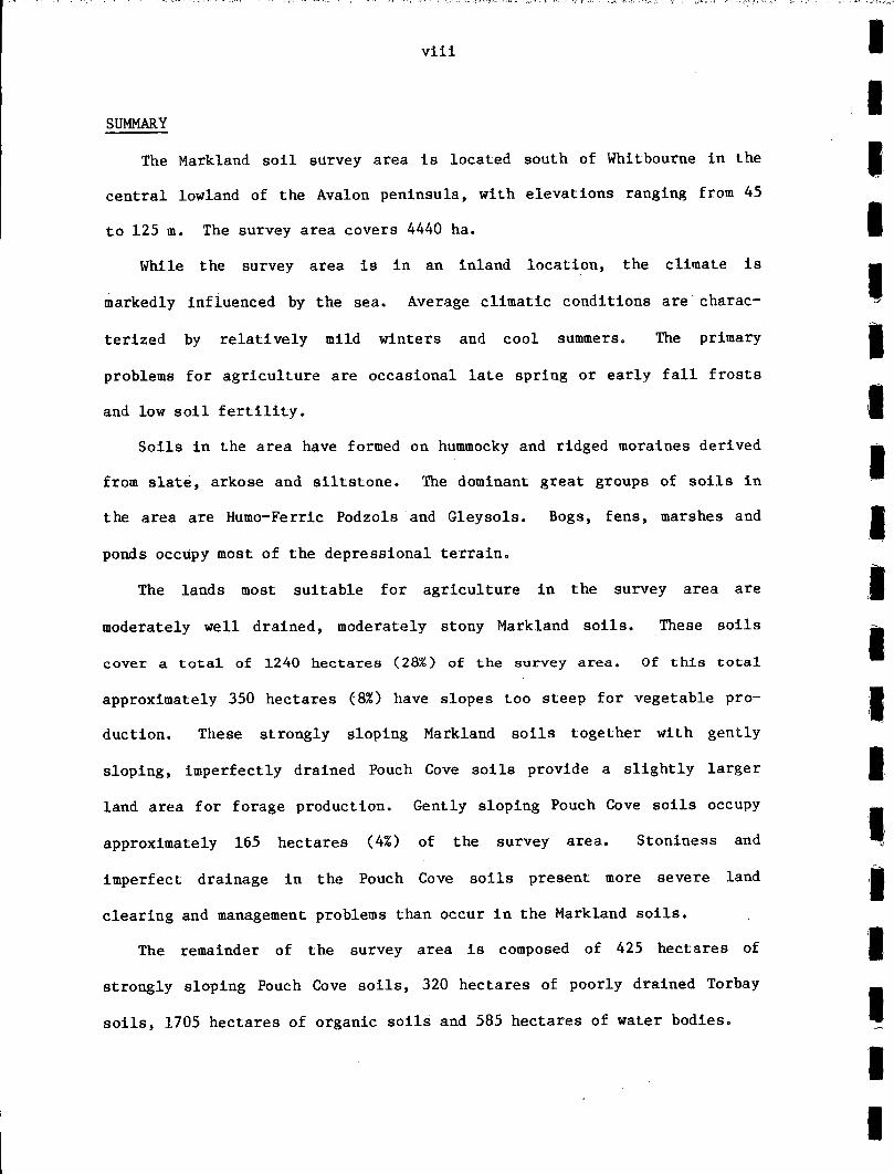
SUMMARY
The Markland soil survey area is located south of Whitbourne in the
central lowland of the Avalon peninsula, with elevations ranging from 45
to 125 m . The survey area covers 4440 ha.
While the survey area is in an inland location, the climate is
markedly influenced by the sea . Average climatic conditions are charac-
terized by relatively mild winters and cool summers . The primary
problems for agriculture are occasional late spring or early fall frosts
and low soil fertility .
Soils in the area have formed
from slate, arkose and siltstone .
the area are Humo-Ferric Podzols - and Gleysols . Bogs, fens, marshes and
ponds occupy most of the depressional terrain .
The lands most suitable for agriculture in the survey area are
moderately well drained, moderately stony Markland soils . These soils
cover a total of 1240 hectares (28%) of the survey area . Of this total
(87.) have slopes too steep for vegetable pro-
sloping Markland soils together with gently
imperfectly drained Pouch Cove soils provide a slightly larger
Gently sloping Pouch Cove soils occupy
of the survey area. Stoniness and
Cove soils present more severe land
clearing and management problems than occur in the Markland soils .
area is composed of 425 hectares of
strongly sloping Pouch Cove soils, 320 hectares of poorly drained Torbay
soils, 1705 hectares of organic soils and 585 hectares of water bodies .
on hummocky and ridged moraines derived
The dominant great groups of soils in
INTRODUCTION
A soil survey is one of of a number of types of land resource inven-
tories used by government and other agencies to plan land resource
utilization or preservation . The prime objective of this survey is to
provide detailed soils information for farm development planning .
A 1 :100,000 scale reconnaissance soil survey of the Avalon peninsula
by P . K . Heringa indicates significant tracts of class 4 and 5 soils in
the Markland area, which are suitable for agriculture . Land with equal
or better potential for agriculture is extremely limited elsewhere on the
Avalon peninsula. A 1 :12,500 scale mapping program was carried out in
the Markland area to describe these soils in more detail for farm devel-
opment planning .
A large proportion of these class 4 and 5 soils lie within an area
unencumbered by land tenure problems. These were the primary factors in
determining the boundaries of the survey . Some privately owned cleared
land along the Markland road was included for purposes of comparison with
the forested lands in the survey area .
The report contains a general description section which discusses
the main soil forming factors such as climate, vegetation, geology and
geomorphology . In the main body of the report the major soils mapped
within the area have been characterized by detailed profile descriptions
with chemical and physical data . There is also a land use section which
describes soil suitability and limitations for agriculture .
The soil map accompanying the report depicts soils with common
physical and chemical properties as they occur over the landscape .
However, these maps provide only a two dimensional picture of the soil -
the third dimension - depth, can only be obtained from the report .

Therefore, to make maximum use of the information collected both the map
and report should be used .
HOW TO USE THE MAP
To use the map and legend, first locate the area on the map to be
studied . The delineation(s) in which the area falls will have a specific
colour along with a simple or complex map symbol (Fig . 1) .
The delineation letter code for mineral soils is an abbreviation of
the dominant soil name found within the delineation . The soil names are
listed alphabetically on the left hand side of the legend . Located hori-
zontally to the right of the soils name is information on parent material
composition, solum texture, drainage, stoniness and soil classification .
The numeric code following the letter code in the mineral soil
delineations represents landform/slope phases . Information on the land-
form/slope phases, where applicable, is given beneath each named soil
The landform/slope phase sections also
soil suitability/limitations .
soils are differentiated primarily on the basis of surface
sloping fen, which has a wooded phase listed
organic soils delineations in the legend are
listed on the left, followed by information on landform, parent material,
drainage and taxonomic classification .
The legend for the Markland soils map is designed to be used with
both the map and report so that information about specific soil proper-
ties and landscape features can be obtained . Due to the complex nature
in the legend .description
contain information on
Organic
morphology,
separately .
except for the
Map codes for

of the hummocky terrain in the area, numerous soil variations occur over
very short distances . Small unmapped inclusions are common in many
delineations . Cross sections of soil-landscape relationships discussed
in a later chapter help in understanding the nature of these changes .
When used in conjunction with the soils map, the soil-landscape figures
aid in presenting a three-dimensional impression of the terrain.
Simple Map Unit Symbol
(mineral soil)
soil name code---- M1 ----landform slope phase
(organic soil)
organic---- 01 ----landform type
Compound Map Unit Symbol
dominant soil---- 04-Tl ----significant soil(50-70%)
(30-50%)
Figure 1 . Simple and complex map symbols .
PREVIOUS WORK
Fieldwork for the Markland soil survey was carried out by Alan
Stewart in 1980 and 1981. The author carried out fieldwork in the area
in 1982 and 1983 . A report and 1 :100,000 scale maps on soils and soil
capability of the entire Avalon peninsula has been completed by P . K.
Heringa (1981) .
A report and maps at a scale of 1 :15,840 on peatlands of eastern
Newfoundland has been completed by Northlands Associates for the Depart-
ment of Forest and Lands (1980) .

GENERAL DESCRIPTION OF THE AREA
Location and Extent
The Markland survey area is located to the immediate south of
Whitbourne, 90 kilometres west of St . John's . The Whitbourne to Colinet
road runs along the western boundary of the survey area . Agricultural
activities around the community of Markland are spread out along this
road .
The survey area encompasses a 4440 hectare block of land situated in
the eastern portion of the National Topographic Series mapsheet 1N5
(Argentia) and western portion of IN6 (Holyrood) . It is an inland loca
tion, with St . Mary's Bay to the south, Trinity Bay to the north,
Placentia Bay to the west and Conception Bay to the northeast (Fig . 2) .
Population Centres
The survey area is located in the central Avalon within a one hour
drive of over half the province's population . This provides ready access
to markets for agricultural products . Road and rail links connect the
area to the province's transportation network . The closest commercial
airport is at St . John's .
The major service centre in the vicinity of the survey area is
Whitbourne, with a population of approximately 1200 people, situated
along the northern boundary of the survey area . The area was settled in
the late 1800's .

Figure 2 .
General Location of the Survey Area .

The community of Markland, with a population of about 400 people, is
located along the western margin of the survey area . This community was
established in the 1930's by the Commission Government as part of an
agricultural development and land settlement program .
Agriculture still forms an important part of the economy of the
WhitbourneMarkland area. Agricultural activities in the area include
vegetable and forage production, broiler operations and commercial
greenhouse production .
Climate
The island of Newfoundland has a marine-modified continental climate .
Significant regional variations in climate occur within this single
classification however. Distinct regional variations are caused by the
cold Labrador current, the Gulf of St . Lawrence, the Gulf Stream and
variations in topography .
The Avalon has been
zone (Banfield, 1981) .
influenced by the sea,
(1500-2000 mm), relatively mild winters and cool
the precipitation in winter falls as snow, snow cover is intermittent,
and freezing rain is common in late winter . The southern Avalon is noted
as having milder winters with less snowfall, and cooler summers with less
sunshine than the northern Avalon. The Markland survey area occupies a
transition zone between the northern and southern Avalon climate zones as
defined by Banfield .
Since meteorological records are not available for the Markland sur-
vey area, data is included for other Avalon locations . From this data
divided into a northern and a southern climatic
Both these zones are defined as being greatly
and having relatively high annual precipitation
summers . Less than half

the general character of climate on the Avalon may be observed . It is
expected that local variations occur in the Markland area .
exception of Salmonier, climatic stations considered are all
the sea . Distinct climatic variations are attributable to
and the influences of northerly or southerly
For example, coastal fogs, cloud cover,
be more pronounced along the
under southerly airflows in summer, than for more
northern or inland locations such as Markland . Upland areas to the east
lowland may contribute to local variations in
With the
adjacent to
this marine exposure,
airflows over the region.
precipitation and cooler temperatures may
southern Avalon,
and west of the central
weather patterns .
Temperature records have been selected from the four closest stations
to the Markland survey area (Tables 1 and 3, and Fig . 3) . The mean daily
temperature for February, the coldest month, ranges from a low of
-4 .20C at Holyrood to a high of -3 .30C at Long Harbour . Extreme lows
for these four locations range from -30 .OOC at Salmonier to -18 .90C
at Holyrood . The warmest months for these stations tend to be July and
owing to the cooling effect of sea temperatures well into
The mean daily temperature for the warmest month ranges from
15 .OOC (July) at Holyrood to 15 .70C (August) at Long Harbour .
Extreme maximum temperatures on record for these four locations range
from 28 .90C for the months of July and August at Colinet to 30 .60C
for the month of July at Holyrood and for the month of August at Long
Harbour .
Temperatures during the growing season and duration of the growing
is adequate for most root and cole crops . Measurement of growing
is a method for evaluating the effectiveness of temperature
August,
summer .
season
degree days

conditions during the growing season for plant growth. It measures the
amount
of
growth producing heat
a -plant
receives
by
values obtained when subtracting
which a plant will not develop, from
north of St . Mary's Bay, including
growing degree-days for a base temperature
temperature at which microbial activity and therefore plant growth
The concept of growing degree days is described in detail in
Crop Production in Canada, Can . Dep . Agr . Publ .
accumulating the
the base minimum temperature, below
the mean daily temperature . Areas
Markland, have in excess of 1100
of 50C, which is the
starts
(Fig . 4c) .
Growing Degree Days and
1635.
The mean dates of the last spring and first autumn air frost (OOC
in screen) varies significantly from one station location
the Avalon Peninsula (Figs . 4a and 4b and
f rost-free period ranges from a low of 94 days at
Colinet to a high of
179 days At Argentia (Table 4) . Extreme lows recorded range from 46 days
145 days at Argentia. Extreme highs recorded range from
St . John's west to 217 days at Argentia . Because of
and prevailing winds, it is felt that the
area may more closely approximate
of farmers in the area
to another on
Table 4) . The average
at Colinet to
133 days at
topography, proximity
frost-free period in the Markland
Colinet than Argentia . Personal observations
tend to support this view.
Total annual precipitation is relatively high over the entire Avalon
peninsula (Fig . 4d) . Monthly totals of rainfall, snowfall and total
precipitation for the four locations with continuous records closest to
the Markland survey area indicate a fair degree of variation (Table 2) .
Total annual precipitation ranges from a low of 1028 .8 mm at Holyrood to
a . high of 1431 .8 mm at Colinet . Rainfall exceeds snowfall in all winter
months, with snowfall as a percentage of total annual precipitation

scm e
o KIL0109111l5 30Cope Race
Figure 3 .
METEOROLOGICAL STATIONS .

Table 2 " Mean Monthly Rainfall, Snowfall and Total Precipitation in millimetres for Four AvalonLocations (AES Data for Period 1951-1980) .
Salmonier Colinet Holyrood Long Harbour
Rain Snow Total Rain Snow Total Rain Snow Total Rain Snow Total
JAN . 87 .0 35 .5 124 .1 88 .9 49 .3 132 .2 84 .0 51 .2 131 .4 87 .0 35.5 124.1
FEB . 79.3 38 .2 130.7 71 .9 48 .1 119 .9 50 .1 44.2 91 .8 65.3 44.3 114 .3MAR . 79 .0 28 .3 114 .4 72 .5 37 .7 110 .5 47 .3 44.8 93 .3 75 .8 34 .6 115.6
APR . 77 .1 9.9 95.2 83.4 16 .0 99.4 51 .3 13.3 66.7 69.5 6.7 79.5MAY 99 .5 3 .1 102 .5 92 .2 3 .4 95 .5 56 .5 0.3 56.1 91.1 4 .3 95 .9
JUNE 90.9 0.0 88.6 100.8 0 .2 101 .0 59 .5 1.4 60.5 89.5 0.0 87 .6JULY 86 .9 0 .0 86 .9 97 .3 0 .0 97 .3 46 .7 0.0 46 .7 75.9 0.0 75.9
AUG . 124.3 0 .0 124 .3 124.5 0 .0 124.5 83 .7 0.0 83.7 113.2 0.0 113.2SEPT 125.2 0 .0 125 .2 115 .2 0 .0 115 .2 82 .0 0.0 82.0 106 .4 0.0 106.4
OCT . 141 .0 0.0 140.6 131 .0 1 .3 132.3 100.6 0.6 102.6 152.9 0.7 152.7NOV . 125 .3 4 .4 128 .4 144 .0 8 .0 153.7 114 .4 1.9 117 .0 131 .3 5.2 134 .5
DEC . 95.3 32.7 151 .2 109 .3 35 .0 144 .3 64 .3 29.4 97.1 91.3 28.1 121 .7YEAR 1232 .8 155.0 1424 .8 1231 .0 199 .0 1431 .8 840.4 187 .1 1028 .9 1149 .7 159 .4 1321 .4
Table 1 . Meteorological Station Locations
Station Latitude/Longitude Elevation Distance and Direction from Markland
Salmonier 47 0 16' N 530 20' W 122 m 14 km southeast
Colinet 470 13' N 530 33' W 27 m 13 km south
Holyrood 470 23' N 530 8' W 11 m 25 km east
Long Harbour 470 25' N 530 49' W 8 m 21 km west
St . John's West CDA 47 0 31' N 520 47' W 111 m 54 km northeast

Table 3 . Mean Minimum, Maximum and Daily Temperatures in degrees Celcius for Four Avalon
Table 4 . Average, shortest and longest frost-free periods for selected Avalon locations (Basedon AES records 1941-1970) .
Locations (AES Data for Period 1951 - 1980) .
Salmonier Colinet Holyrood Long Harbour
Min . Max . Daily Min . Max . Daily Min . Max . Daily Min . Max . Daily
JAN . -8.2 -0.1 -4 .1 -7 .2 0.6 -3 .4 -7.6 1 .1 -3.3 -6.2 1 .1 -2.6
FEB . -8 .2 0.1 -4 .1 -7.9 0.4 -3 .8 -9.1 0.7 -4.2 -7 .0 0.5 -3 .3
MAR . -5.5 1.8 -1 .9 -5.0 2 .5 -1 .3 -6.5 2.4 -2 .0 -4 .3 2.3 -1 .0
APR . -2 .1 5.5 1 .7 -1 .3 6.2 2 .4 -3 .3 5.6 1 .2 -0 .7 5.9 2 .6
MAY 1 .7 10.3 6 .0 1 .6 10 .2 6 .0 -0.1 10.2 5 .1 2 .5 9 .9 6 .2
JUNE 5 .8 15 .8 10 .8 5 .8 10.1 14 .3 4 .0 16 .3 10.2 6 .2 14 .3 10.4
JULY 10 .4 20.1 15 .4 10 .3 18.3 14 .3 9 .0 20.8 15.0 11.1 18 .6 14.9
AUG . 10 .9 19.7 15 .4 11 .4 19.1 15 .3 8 .9 20.6 14.9 12.2 19 .1 15.7
SEPT 7 .9 16.2 12 .1 7 .4 16.1 11 .8 5.2 16.8 11.1 9 .4 16.3 12 .9UCT . 3 .8 11.2 7 .5 3 .4 11 .4 7 .4 1.6 12 .3 7.0 5.4 11 .7 8.6NOV . 0.4 7 .1 3 .9 0.3 7 .4 3.9 -1.5 8.2 3 .4 1 .4 8.0 4.7DEC . -4 .7 2.6 -1 .1 -4.8 2.7 -1 .1 -5.6 3.6 -1 .0 -3 .7 3 .2 0.2
YEAR 1 .0 9.2 5 .1 1 .2 9.1 5 .1 -0.4 9.9 4.8 2 .2 9.2 5 .7
Average last frost (Spring)
Average first frost (Fall)
Colinet
June 20
Sept . 09
Holyrood
June 10
Oct . 01
St . John's West CDA
June 12
Sept . 19
Average frost-free periods (days) 94 112 98
Shortest frost-free period (days) 46 50 55
Longest frost-free period (days) 135 161 133Years of record 30 12 20

AVERAGE DATE OF LAST SPRINGFROST(0C)
AVERAGE ANNUAL DEGREE-DAYSABOVE 5°C
AVERAGE ANNUAL PRECIPITATION(mm)
Figure 4 .(z-Meteorological Stations)
- 1 3 -
ranging from a low of 11% at Salmonier to a high of 18 .2% at Holyrood .
Precipitation is relatively evenly distributed throughout the year, with
slight lows in spring and summer, and highs in fall and winter.
Winds throughout the Avalon Peninsula are relatively frequent and
strong . Southwesterly winds prevail in summer, with easterly and
northerly winds being common in spring and autumn.
Agriculture has been shown to be successful on the Avalon for
climatically suited crops and farming practices . Excess precipitation,
conditions, cloudiness and frost present high risks to
management before the end of May . These risks decrease
There is a moderately low risk of
wetter or drier than average . The
under average climatic conditions,
starts to increase in the latter half of September, because of cooler
temperatures with risk of frost, and increasing precipitation .
saturated soil
crops and field
sharply by the latter half of June .
poor yields in summers that are much
risk factor to crops and harvesting,
Micro-climate
The Markland survey area covers part of an extensive zone of gener-
ally east-west trending ribbed and hummocky moraines extending from the
Argentia access road area in the west to the Salmonier River in the east .
A distinct vegetation pattern developed on these ridges is discussed more
fully in a following chapter . The south-facing slopes are covered by a
scrub black spruce and balsam fir forest ; the upper north slopes are
characterized by a productive growth of balsam fir and white birch ; and
the lower north slopes are covered by a productive growth of balsam fir .

- 14 -
Studies by Department of Forest, Resources and Lands personnel have
concluded that this vegetation pattern can be partly explained by
micro-climate conditions (Delaney and Cahill, 1978 ; Delaney, Cahill and
Chow, 1984) . These studies have demonstrated a close relationship
between micro-climate variables, such as wind direction and strength ;
air, ground, and soil temperatures ; and vegetation patterns on the ribbed
moraines .
The prevailing summer winds from the southwest were shown to be
strongest on the south slopes . Day and night air temperatures (2 m
height) were found to be 6-80C higher, on average, on the upper north
slope, than on the south and lower north slopes . Ground level maximum
air temperatures were found to be highest on the upper north slope and
south slope and lowest on the lower north slope . Greatest diurnal
variation occurred on the south"slope . Soil temperatures were found to
be warmest and most responsive to air temperature increases on the upper
north slope . Cooler air and soil temperatures on the lower north slope
were attributed to limited exposure to direct sunlight . Cooler air
temperatures (2 m height) on the south slope were attributed to greater
air mixing by exposure to the prevailing wind . Cooler air at night would
tend to pool in depressions and lower slope areas - creating a greater
frost risk in these locations . Higher air temperatures on upper slopes
would promote greater water uptake by plants and hence, more productive
vegetation growth.
Studies have not been done on cleared land to determine what changes
would occur in the micro-climate . It can be inferred that observed
patterns in air temperature and wind velocity on forested moraines would

be less extreme on cleared equivalents . The cooling effect of air mixing
could be reduced somewhat by maintaining an adequate tree screen on the
south slopes .
Topography
The Markland survey area occupies part of the central lowland of the
Avalon peninsula. Elevations range from 45 to 125 m . The lowest eleva-
tions occur along the Hodge River on the western fringe of the survey
area . The highest elevations occur in the area west of Long Pond and
Ocean Pond .
The entire survey area is covered by an irregular complex of ridged
and hummocky terrain separated by ponds and organic deposits . These
ridges are most pronounced in the north and are sometimes more than 30 m
high with some slopes exceeding 30% .
Towards the southern portion of the
survey area the ridges and hummocks seldom exceed 15 m in height . Many
of the ridges are bias-sided with the steeper slopes commonly facing in a
southerly direction .
The irregular nature of the terrain is the primary reason for the
complex arrangement of soils and soil drainage conditions occurring in
the survey area . The key limitations to agricultural use of soils in the
area are drainage and slopes . These factors are emphasized in the map
legend and are also portrayed in cross-section diagrams of the terrain,
in another chapter of this report .
Drainage
Soil Draina&e
With the exception of the extreme northwest corner, the entire survey
area is drained by the Hodge river and a number of smaller streams which
empty into the southward flowing Rocky River southwest of the survey
area. A major portion of the north central section of the survey area is
covered by an irregular complex of ponds . Water bodies cover a total of
585 ha in the survey area . The southwest portion of the survey area is
noticeably lacking in ponds and major streams . Streams in the area have
gentle gradients, owing to the lack of any major variability in surface
relief .
separated by ponds
upper slopes and crests
drained . Runoff and transmissibility
area is dependent on a number of key variables :Soil drainage in the
precipitation/evapotranspiration, soil textures /permeability, soil struc-
ture and slope gradients . Relatively high precipitation combined with a
low potential evapotranspiration results in a general surplus of avail-
able soil water throughout the year on the Avalon peninsula .
Soil textures and slope gradients are closely related to the nature
of the terrain in the survey area . The characteristic feature of the
terrain is the abundance o£ irregular glacial till ridges and hummocks
and organic deposits . The Markland soil, occurring on
of ridges and hummocks is moderately well
vary somewhat due to irregular
slopes and variable textures in the solum . Strongly sloping Pouch Cove
Seepage is common in the top 25 cm of the
very weak to massive
soils are imperfectly drained .
solum . Drainage is hindered by a number of factors :

soil structure, impermeability of fine textured surface horizons, thick
moss cover, and occasional placic horizons corresponding to lines of
seepage and texture gradients .
Gently sloping Pouch Cove soils are characterized by poor surface
drainage ; but are moderately well drained internally . Surface runoff and
transmissibility are impeded by gentle slopes, a peaty surface cover and
fine textures in the upper portion of the solum .
The Torbay soil, occurring on toe slopes and gentle inclines, is
poorly drained . The surface is commonly saturated throughout the
summer. These soils typically have a peaty surface cover over an imper-
meable layer.
Poorly to very poorly drained organic soils occupy most of the
depressional terrain . On the domed bogs, slope bogs and wooded slope
fens the water table may drop below the surface layer for significant
portions of the summer . Slope fens and horizontal marshes in the area
may be partly water-covered throughout the summer .
Geology
Geological formations in the area are of sedimentary origin and occur
as a north-south trending eroded syncline and anticline sequence of low
relief (McCartney, 1967) . The syncline is centered on the lower surface
relief along the Hodge river in the western portion of the survey area .
The anticline occurs along a zone of slightly higher relief in the
eastern portion of the survey area .

- 18 -
Rock types are intermixed throughout the survey area ; with gray
slate, red and green arkose and wavy-bedded siltstone being predominant .
These rock types contribute to the extreme acidity of Markland area soils .
Rock outcrops are rare in the survey area, and are generally confined
to sections of stream beds and man-made surface cuts .
Surficial Geology/Soil-Forming Materials
The surficial geology of the Avalon peninsula, including the Markland
survey area has been described by a number of authors (Henderson, 1972 ;
Rogerson and Tucker, 1972) . The survey area was glaciated during the
Wisconsin period, with deglaciation having occurred more than 10,000
years B .P. Ice flow appears to have been towards the north. The most
characteristic feature of this terrain is the complex assemblage of
irregular moraines . These moraines are thought to be ice
recessional deposits (Henderson 1972, Rogerson Pers . Coms . 1981) .
north, east, and south portions of the survey area these moraines are
more east-west oriented . Along the western fringe they take on a more
north-south alignment . In the central portion of the survey area there
is no observable alignment of the ., terrain . In the north and east, the
relief of the moraines is generally more pronounced (15-30 m) than in the
south (usually less than 15 m) . Many of the moraines are bias-sided,
with the steeper slopes commonly on the south side .
Organic deposits, sometimes in excess of 5 m thick, and ponds
most of the depressions . Minor beach terraces, 3 to 5 m above present
water level, in the area of Second Pond, are indicative of glacio-
lacustrine conditions having existed in the area . The lack of any major
f ront
In the
occupy

deposition or sorting of materials indicates that this pro-glacial lake
was of limited extent and duration . Fine surface textures and pockets or
lenses of roughly sorted sand, silt and gravels in the till, is
indicative of both sporadic meltwater flow at the time of deposition and
postglacial erosional and depositional processes .
The parent material of mineral soils in the area are derived from
slate, arkose, wavy-bedded siltstone and minor amounts of manganese-rich
rock fragments . The parent material is gravelly to very gravelly sandy
loam, with a moderately low stone content . Boulders are rare on crests
and upper slopes ; while lower slopes are slightly bouldery . Solum
textures range from loam to silt loam on ridge crests, to silty clay loam
in depressions . The parent material is moderately compacted throughout
the area .
Minor alluvial deposits occur in the area of Bethune's Pond at the
mouth of the Hodge River and along a stream flowing north into Brazil's
Pond from Long Pond . These were too small to map individually .
Organic soils in the area are developed on accumulations of peat .
Bogs in the area are composed of slightly to moderately decomposed
sphagnum moss, with significant amounts of sedge and minor amounts of
wood, especially in lower strata . Fens and marshes in the area are
composed of moderately to strongly decomposed sedge ; with sphagnum moss
locally common near the surface, and woody material in lower strata .
Thickness of peat deposits range from 3 to S m for bogs, 1 to 2 m for
fens, and 3 to 6 m for marshes .

Vegetation
- 20-
The Avalon peninsula lies within the Boreal Forest Region (Rowe,
1959) . This region is characterized primarily by balsam fir, black
spruce, and larch; with broad-leaved species such as white birch,
mountain ash and mountain maple on sheltered sites .
In the Markland survey area significant changes to the natural vege-
tation have resulted from extensive logging in the first half of this
century, fire succession, firewood cutting, and forest silviculture
projects . The Markland soil on moderately well drained and sheltered
sites on ridge crests and upper slopes is forested with a productive
growth of balsam fir, with concentrations of large mature white birch,
mountain ash and mountain maple on more, . sheltered sites . A thick moss
cover predominates under balsam fir cover ; while ferns are the most
common ground cover in birch stands . Larch, black spruce and heathland
vegetation are common on old burnt-over sites . A mixed cover of black
spruce and balsam fir predominates on imperfectly drained Pouch Cove
soils occurring on steep slopes . A wide variety of ericaceous
shrubs also occur. Ground vegetation consists of a thick
woodland mosses and minor sphagnum . Pouch Cove soils occurring
sloping terrain and exposed sites are
spruce and larch, and heathland vegetation.
thick cover of woodland mosses, caribou moss
The vegetation of poorly to very poorly
slopes and gently to moderately inclined
depending on the nature of exposure,
nutrient supply. On some sites productive growth of balsam fir, with a
and other
cover of
on gently
covered by scrub growth black
The ground cover includes a
and sphagnum .
drained Torbay soils on toe
areas varies substantially,
surface runoff and available

ground cover of moss, fern and sedge occur . At other sues heathland or
wetland vegetation is typical .
Wetland vegetation in the area varies primarily according to water
levels and nutrient regime present . Oligotrophic (nutrient poor) condi-
tions prevail on domed and slope bogs . Surface vegetation is primarily
sphagnum moss, sedge and caribou moss ; with scattered larch, black
spruce, bog laurel, Labrador tea and black cranberry, bake-apple, pitcher
plant and sundew .
Mesotrophic (moderate nutrient supply) conditions are more common on
slope fens and wooded fens . Sedges are usually dominant over sphagnum
mosses ; with a wide variety of other species, including those listed for
oligotrophic conditions, being common. Other species occurring include
sweetgale, blue-eyed grass, marsh blue violet, tall meadow-rue, and small
cranberry . Some sheltered sites have tree growth of balsam fir, black
spruce and larch, with a ground cover of woodland mosses, sphagnum moss
and fern .
Eutrophic (nutrient rich) conditions occur in marshes, around ponds
and slow-flowing streams in the area . Sedges are the most common plants
under these conditions, with horsetails and cattails being locally abun
dant . Other species occurring include the northeastern rose and blue
flag .
MAPPING TECHNIQUES AND SOIL CLASSIFICATION
Survey Methods
Named soils defined for the Avalon peninsula by Heringa (1981) were
the basis for differentiating soils in the Markland area . Heringa's

mineral soils are differentiated in the map legend by : soil taxonomy at
the subgroup level, parent materials, surface texture and surface stoni-
ness and drainage . In the Markland map legend, landform slope phases
were added .
Mapping concepts are based on "A Soil Mapping System for Canada :
Revised", prepared by the Mapping Systems Working Group for the Expert
Committee on Soil Survey, 1981 .
A literature review was completed covering topics on climate, geology,
geomorphology, vegetation and soils . This information provided the back-
ground for identifying and mapping soils in the Markland area . It also
provided background information for making agricultural interpretations .
Soils were mapped on 1 :12,500 color photographs, using landform,
vegetation and drainage as the primary differentiating criteria . Air
photo delineations were checked in the field, to identify soil
characteristics and verify unit boundaries. Fieldwork was carried out
primarily by foot and canoe traverses, as road access was limited .
Profiles were examined in pits dug at irregularly spaced intervals,
depending on the nature of the topography, throughout the survey area .
Most site inspections involved filling out a daily field sheet containing
on parent material, lithology, drainage, stoniness, texture,
horizon characteristics, soil classification and vegetation .
Hiller peat sampler or Dutch
information recorded for vegetation, drainage, surface
stages of decomposition, depth to mineral layer
information
slope, soil
Organic
auger ; with
morphology, composition,
and soil classification .
- 22-
soils were checked using a

- 23-
A total of 700 daily field sheets were filled out for sites through-
out the survey area . Additional site inspections, not recorded on daily
field sheets, were conducted for boundary checks, and for noting special
features such as gravel pits and rock outcrops.
Detailed profile descriptions were taken at representative sites for
named soils identified in the area and entered in a CanSIS Field Descrip-
tion Input Form . In addition to the type of information collected at
routine inspection sites, the detailed forms also include information on
soil structure, porosity, consistence, humus form, rooting, and coarse
fragments . At all detailed pits, samples were taken from each soil hori-
zon. These samples were sieved, sterilized using an autoclave and
forwarded for physical and chemical analyses to the Agriculture Canada
Land Resource Research Institute in Ottawa .
A 1 :12,500 final scale soils map and legend was compiled based on the
literature review, air photo interpretation, field inspections and labor-
atory analyses of soil samples . Based on this information, selected
interpretations were made for agriculture ; an interpretative overview for
forestry, engineering, wildlife and recreation is included also .
Laboratory Methods
Following the detailed descriptions of all major soils is a table
chemical and physical analytical data . The analyses on all soil samples
were completed by the Analytical Services Laboratory, Research Branch,
Land Resource Research Institute, Agriculture Canada, Ottawa . The
following analyses were performed by the laboratory, the methods are
outlined in the "Manual on Soil Sampling and Methods of Analysis", J.A.
of

McKeague (ed .), 1978 and are indicated by bracketed numbers : pH - 0 .01 M
CaCl2 (3 .11) ; % carbon - CHN auto analyzer ; extractable Fe, Al, Mn -
sodium pyrophosphate extraction (3 .53) ; permanent charge CEC and
exchangeable cations - NaCl extraction (3 .31), or by Barium Acetate for
organic soils (3 .36) ; available P - phosphorous extraction by "medium
strength" Bray Extract (4.43) ; % organic matter/ % ash for organic soils
- loss-on-ignition (4 .23) ; total nitrogen - auto analyzer ; particle size
distribution - pipet method with a pretreatment to remove carbonates,
organic matter and soluble salts (2 .11) .
Soil Classification
- 24-
The soils mapped in this survey are differentiated at the level of
subgroups and slope phases for each parent material . Specific character-
istics for differentiating the named soils are discussed in the preceding
methods section . The soils classification is based on the "Canadian
System of Soil Classification" developed by the Canada Soil Survey
Committee, 1978. The soil description format is based on the "Manual for
Describing Soils in the Field" by J . Dumanski (ed .), 1978.
In the Markland area, three soil orders have been recognized :
Podzol, Gleysol and Organic (Table 5) .

Rego
Gleysolic (order)Gleysol (great group)
Organic (order)Mesisol (great group)
Humisol (great group)
- 2 5-
Table 5 . Classification of the soils mapped in the Markland area by
subgroup
slope phase
soil name
gently sloping
Torbay
subgroup
landform phase
soil name
Terric
domed bog
Organic 1
Typic
slope bog
Organic 2
Terric
slope fen
Organic 3
subgroup
landform vegetation phase
soil name
Terric Fibric
wooded slope fen
Organic 4
Typic
horizontal marsh
Organic 5
order,
PodzolicHumo-Ferric
great group, subgroup and landform
(order)(great group)
or vegetation phase .
subgroup slope phase soil name
Orthic gently sloping Markland
Orthic moderately sloping Markland
Orthic strongly sloping Markland
Gleyed strongly sloping Pouch Cove
Gleyed gently to moderately sloping Pouch Cove

Soil-Landscape Relationships
landscape .
Balsam Fir
- 26-
Most of the soil delineations have been illustrated by a series of
cross-sections or soil-landscape diagrams (Figs . 6-10) . These idealized
cross-sections contain the names of simple and complex mapping units
located between the vertical lines . The aspect of the diagram is
indicated in the top left and right hand corners . The parent material
symbols have been placed on each diagram along with symbols for seepage .
Fig . 5 contains the key to the vegetation symbols used in the cross-
sections .
It is important to note that these diagrams are not drawn directly to
scale : their function is to indicate the occurrence, distribution, and
association of each soil with other soils and non-soils within the
White Birch
Black Spruce
Mountain Maple
Black Spruce, Scrub
Ericaceous Shurbs
Figure 5. Key to the vegetation symbols used in the landscape cross-sections .

- 2 7-
S
Till
Organic
-~
Lateral Seepage (pronounced)----~
Lateral Seepage (occasional)--?-
Bedrock Surface (assumed)
Fig .6 MODERATELY SLOPING RIDGE (IDEALIZED SOIL- LANDSCAPE RELATIONSHIP)
--'~
Lateral Seepage (pronounced)---~
Lateral Seepage (occasional)-?-
Bedrock Surface (assumed)
Fig .7 STRONGLY SLOPING RIDGE (IDEALIZED SOIL-LANDSCAPE RELATIONSHIP)

N
_28_
Markland
Pouch Cove
Gentle to Moderate Slope
I Strong Slope
Till
-4 Lateral Seepage
-?-
Bedrock Surface (assumed)Organic
Fig . 8 GENTLY SLOPING RIDGE (IDEALIZED SOIL- LANDSCAPE RELATIONSHIP)
Till
--4
Lateral Seepage
-?-
Bedrock Surface (assumed)Organic
Sloping Bog
Fig .9 GENTLY SLOPING RIDGE (IDEALIZED SOIL- LANDSCAPE RELATIONSHIP)

of Wooded Slope Fen (04) , and Torbay
Fig. 10
GENTLY INCLINED TERRAIN (IDEALIZED SOIL- LANDSCAPE RELATIONSHIP)
INTERPRETATIONS
Agricultural Suitability/Limitations
- 30 -
As is the case throughout Newfoundland, the Markland area is charac-
terized by a short growing season, restricting agriculture to a limited
range of crops and cropping practices . Low yields may be expected in
some years due to late spring frosts, early fall frosts, lower than aver-
age summer temperatures, and higher than average precipitation and/or fog
conditions .
Based on climatic data available and the history of agricultural
practices in the Markland area, it can be expected that with good
management practices, agriculture will be successful for locally adapted
crops. For example, timely use of transplants for crops such as cabbage
and cauliflower will help maximize the potential of the effective growing
season .
Historically the primary land use in the Markland area has been agri-
culture. . Under the auspices of the Commission of Government in the
1930's, significant tracts of land were cleared for agriculture along the
Markland road . Today, much of this land lies idle due to landowner
absenteeism, fragmentation of the original land grants, pursuit of alter-
native occupations, and physical constraints such as steep slopes .
Several full-time commercial farming operations still exist in the
area. Vegetable farming is the primary activity ; with lesser emphasis on
forage, cattle and greenhouse production .
The nature of the terrain in the Markland survey area poses some
serious problems to the further development for agriculture of suitable
soils occurring there . Extreme variability in the topography renders
much of the otherwise good soil unsuitable for cultivation due to
steepness . This aspect of the terrain is covered to some extent in the
mapping format and in the individual soil suitability ratings in this
chapter. When looking at the soils map, it becomes obvious that areas of
suitable soil are also small and separated by poorly drained soils, bogs
and ponds . This creates problems in the development of access roads and
in the use of machinery, which contributes to increased operating
expenses .
Problems were encountered in separating individual slope classes on
the map because of the small size and complexity of individual landforms .
Slope patterns are covered in the soils descriptions and soil-landscape
sections of this report .
Area counts of soils and non-soils mapped in the survey area are
summarized at the end of the interpretations section (Table 6) .
A discussion of the agricultural suitability and limitations of
mineral and organic soils occurring in the Markland survey area is given
below .
Mineral Soils
1 . Markland soil - gently sloping ridges and hummocks (145 ha)
With the exception of contrasting inclusions (up to 10% of a map
unit) all of each map unit is considered suitable for locally adapted
crops and cropping practices . Significant limitations or management
problems within these units and possible corrective measures are as
follows : (1) Surface stoniness is generally moderate . Occassional
flagstones and boulders are also encountered . This limitation may be

- 3 2-
overcome with moderate effort .
(2) Coarse fragment content (gravel -
angular cobbles) ranges from 10-559 by volume in the solum . These
variable within an individual map unit .
percentage coarse fragments are poor or
such as carrot and parsnip . (3)
high application of
(4) Very weak soil
content in the solum, results in
Use of machinery is
soil compaction may be severe .
by minimizing machinery use under such
matter to improve soil structure . (5)
dry periods in summer soil droughtiness may be
when putting in transplants . This risk may be
lessened by transplanting crops under moist field conditions, or by
irrigating until plants are well established . Also, the addition of
organic matter may help improve soil structure and available moisture
supply.
percentages are often quite
Areas of soils with a high
unsuitable for deep rooting crops
Low fertility and pH of this soil necessitates
fertilizers and lime for sustained production.
structure, combined with high silt
poor trafficability when the soil is saturated .
slowed under such conditions and
These problems may be lessened
conditions, and adding organic
During extended warm,
a problem, especially
2 . Markland soil - moderately sloping ridges (1055 ha)
20-30% of this map unit has slopes of
are considered too steep for
moderately high erosion hazard .
only for pasture . The suitability
part of the unit are described
gently sloping ridges and hummocks .
more than 15% . These slopes
mechanized agriculture . There is also a
This portion of the unit is suitable
and limitations for the greater
for the Markland soils occurring on

- 33-
3 . Markland soil - strongly sloping ridges (40 ha)
More than 50% of this map unit has slopes more than 15% . Except for
proportions, the relative merits and limitations of this unit are as
described for the Markland soils occurring on moderately sloping
ridges .
4 .
Pouch Cove soil - steep slopes, usually more than 157. (425 ha)
With the major portions of this map unit having slopes of more than
15%, the unit is generally unsuitable for agriculture . Also,
drainage is imperfect and seepage is common within 30 cm of the
surface . The unit is very stony and slightly bouldery ; pH and
fertility are low .
5. Pouch Cove soil - gentle to moderate slopes (165 ha)
The soil limitations occurring in this unit are such that suitability
is restricted to rough pasture or the production of perennial forage
at best . The major limitations encountered, and management practices
required, in this unit are : (1) The unit is very stony to
exceedingly stony, necessitating a large amount of stone clearing .
(2) Surface drainage is poor, with internal drainage being imperfect
to moderate . The surface organic cover would have to be stripped and
the soil allowed to dry . (3) Ditching and/or breaking up the
impermeable surface horizons would help in improving soil structure
and drainage. (4) Low fertility and pH necessitates the addition of
large amounts of fertilizer and lime . (5) Severe trafficability
problems are encountered when clearing this soil . Effective use of
6 .
machinery for land clearing and maintenance is restricted to periods
of dry weather. Some of the excess moisture in this soil can be
eliminated by processes noted above, and by rotovating the topsoil and
applying organic matter to improve soil structure :
The amount of effort required to clear and maintain this soil is
prohibitive except when being considered for expansion with areas of
more suitable soils .
Torbay soil - toe slopes and inclines (415 ha)
This soil is unsuitable for agriculture . The soil is very poorly
drained ; with impermeable fine textured surface horizons, resulting
in extended periods of saturation throughout the growing season. The
surface is usually very stony to exceedingly stony, and slightly
bouldery .
Organic Soils
- 34-
Organic soils were checked for such parameters as drainage, slope,
surface vegetation, origin of peat material, decomposition and thickness
of deposit . From these data generalized interpretations were made for :
(1) agriculture, (2) horticultural peat, (3) fuel peat, (4) raw material
for compost, and (5) to what degree the different organic soils form a
barrier in accessing mineral soils .
1 . Domed bogs (585 ha) : The slight to moderately decomposed sphagnum
and sedge peat in the near surface horizons is fair to poor for agri-
culture, horticultural peat, and fuel peat . Recent testing indicates

- 35-
that this material is well suited as raw material in composting, such
as with fish offal. Domed bogs in the area are typically 3 to 5 m
deep . This creates a severe problem in constructing access roads
from one mineral soil ridge to another .
2 . Slope bogs (290 ha) : These organic deposits are similar to domed
bogs in most respects .
3 . Slope fen (70 ha) : Very poor surface drainage, mixed composition and
nature of decomposition render these deposits poor to unsuitable for
agriculture, horticultural peat, fuel peat, or as a source of compost
material . Very poor drainage and 1 to 2 m thickness of these deposits
also pose a problem in road construction .
4. Wooded slope fen (625 ha) : Except for a wooded surface cover, these
deposits may be interpreted the same as for the slope fen.
5. Stream marsh (40 ha) : An unstable surface and periodic flooding
renders this map unit unsuitable for agriculture, horticultural use,
fuel peat, or as a source of compost material . The unstable surface,
periodic flooding and the 3 to 6 m thickness of these deposits also
form an impassable barrier to road construction .
Forest CapabiliM
Forestry capability of moderately well drained ridges (Markland
soils) in the area is generally Class 5 (Canada Land Inventory 1972),

limited mainly by low fertility . The ridges are generally small and
separated by ponds and bogs, limiting commercial potential . On imper-
fectly drained slopes (Pouch Cove soils) the capability ranges from class
5 to 7, with the degree of exposure being a prime limiting factor to
productive forest growth. The forest capability of poorly drained Torbay
soils and very poorly drained organic soils found on gently inclined
slopes and depressions is generally class 7 with the exception of minor
areas of productive growth on some sheltered toe slopes and on wooded fen
peats . The primary limitations are . very poor drainage and exposure to
wind .
Wildlife Capability
The diversity of undeveloped terrain, variety of vegetation, and the
of ponds and streams in the survey area, provide good wildlife
The capability is moderately high for moose, snowshoe hare,
mink, muskrat, beaver, and a
species .
project sponsored by The Salmon Enhancement
presently ongoing in the Rocky River
abundance
habitat .
grouse, . waterfowl, brook trout, ounaniche,
number of other locally indigenous
A salmon enhancement
Association of Newfoundland is
drainage system (Meaney, 1984) .
Recreation .Capability
- 36-
diversity of forested ridges, bogs,The
flowing
for dispersed
ties as hiking, hunting, boating ; canoeing, trout fishing and
streams, and wildlife in the
recreational activities . Potential exists for
marshland, ponds, gently
potential
such activi-
camping .
area provide a moderate
Selected Engineering Interpretations
- 37-
Engineering interpretations can be quite varied, often requiring
quantified data not available in this survey . As such, interpretations
made are restricted to a few basic items for which quantitative and
qualitative information is available : suitability for aggregates, road
bed layout, foundation construction and septic tank systems . These items
of particular concern for farm development planning . Theare
interpretations, being somewhat subjective, are presented qualitatively .
Information is synthesized from various sections of the report and
Department of Mines and Energy aggregate resources data and geology maps .
The parent material of the mineral soils in the area is gravelly to
very gravelly sandy loam with 10 to 256 silt and clay . (Percent silt and
clay is expressed in terms of the full range of particle size classes
represented in the parent material .) The material is derived from slate,
arkose sandstone, and wavy-bedded siltstone .
the pebble fraction ranges from 3 (fair) to
are rare, with overburden thicknesses of
exceeding 15 m throughout the area . Drainage
on ridge crests to very poor in depressions .
variable, sometimes in excess of 40% on ridged terrain .
Aggregate material is available in large quantity, but relatively
high silt and clay content and fair to poor petrographic characteristics
limits potential useage to secondary road construction and fill .
Concrete aggregate, and class A material for road construction are not
available in the survey area .
The petrographic factor of
5 (poor) . Bedrock outcrops
ridged moraines commonly
ranges from moderately well
Slope gradients are quite

- 38-
Road-bed layout is restricted by strong slopes, poor drainage in
depressions, and extensive organic deposits . The degree and distribution
of these restrictions may be inferred from the soils map .
Foundation construction is limited primarily by areas of poor drain-
age . Moderately well drained ridges have no severe restrictions for this
category.
Septic systems are limited in the survey area by steep topography,
areas of poor drainage and, to a lesser extent, fine soil textures .
Slope limitations occur on the' side slopes of pronounced ridges in the
area . Imperfectly drained seepage soils occur along some of the steeper
ridge slopes . Poorly drained soils occur on toe slopes, inclines and
depressions. Fine soil textures are prevalent throughout the survey
area, but are slightly more pronounced in imperfectly to poorly drained
areas . Geographic distribution of prohibitive factors, such as slopes of
more than 15y, poor drainage, and proximity of ponds, streams and organic
deposits, may be observed on, or inferred from, the soils map .

- 3 9-
Table 6 . Area counts of the soils, with slope and landform phases andnon-soils mapped in the Markland survey area .
Soil andNon-soil name Surface form phase
MapCode
TotalHectares
Percentageof Area
Markland gently sloping ridges Ml 145 3 .3
Markland moderately sloping ridges M2 1055 23 .8
Markland strongly sloping ridges M3 40 0 .9
Organic domed bog 01 585 13 .2
Organic slope bog 02 290 6 .5
Organic slope fen 03 70 1 .6
Organic wooded slope fen 04 625 14 .1
Organic horizontal Marsh 05 40 0 .9
Pouch Cove strong slopes P1 425 9.5
Pouch Cove gentle slopes P2 165 3 .7
Torbay (3) very gentle slopes Tl 415 9.3
Water 585 13 .2
Total 4440 100

MAP UNIT DESCRIPTIONS
Mineral Soils
- 40-
Markland map unit 1 - gently sloping ridges (145 Ha)
Location :
The gently sloping Markland soil occurs on crests and upper slopes
of gently sloping till ridges throughout the survey area .
Parent material:
The parent material is a gravelly sandy loam compacted glacial till
derived from slate, arkose and siltstone . These map units are generally
moderately stony .
Topography :
Slopes are usually less than 10% .
Drainage :
This soil is moderately well drained .
be hampered by vegetation and a compact parent material .
Vegetation:
Balsam fir cover is predominant ; with
birch prevailing on sheltered sites .
of woodland mosses ; with lesser amounts
corn lily, creeping snowberry,
Soil Classification :
Orthic Humo-Ferric Podzol .
Soil characteristics :
In some places drainage may
of whitescattered stands
Ground cover consists of a variety
of fiddlehead fern, Canada yew,
starflower and bunchberry .
Thickness of LFH and Ae horizons is variable . Bhf horizons of
variable thickness are present in some profiles . Surface textures vary
from loam to silt loam and 'become coarser towards the C-horizon ; with
gravel content variable in all horizons .

Associated soils :
Imperfectly drained Pouch Cove soils
slopes below the Markland soil.
soils occur on toe slopes and in
Land use :
This
practices . Primary
moderate stoniness .
problems when the soil is wet .
limits suitablility for deep rooting crops such
Description of a representative profile :
Pond on a flat ridge crest at an elevation of approximately 85 m .
slow
Horizon
- 41 -
soil is suitable for locally adapted crops and cropping
limitations for agriculture are low fertility and
Silty surface horizons
Variable gravel content in the solum
carrot and parsnip .
Soil profile described is located 1 km
The site is moderately well drained; with slow runoff, moderately
transmissibility and moderately low moisture-holding capacity .
Site vegetation cover is predominantly wind-pruned mature balsam
fir with minor white birch.
Ground cover is predominantly plume and step
mosses ; with minor Canada yew, starflower and creeping snowberry .
Surface stoniness is moderate .
Depth cmRange
LF 10-0(6-22)
occur
Poorly drained Torbay
depressions .
as
on middle and lower
soils and organic
contribute to trafficability
northwest of White Hearts
Description
Dark reddish brown (5YR 2 .5/2 to 5YR 3/2 m)slight to moderately decomposed mixture ofmosses, needles, leaves and woody material ;loose, somewhat matted, numerous voids ; highfiber content, non-greasy ; abundant, coarse,horizontal roots ; clear, wavy boundary .

Ae 0-4(2-9)
- 42-
Light gray (l0YR 7/2 m, 10YR 7/1 d) silt
Brownish yellow (lOYR 6/6 m), light yellowishbrown (2 .5Y 6/4 d), very gravelly silt loam ;weak, coarse, subangular blocky structure ;sticky, friable, slightly plastic consistence ;plentiful, medium, horizontal, roots ; common,fine, random pores ; 55% subangular cobbles andangular gravel ; gradual, wavy boundary .
Grayish brown (2 .5Y 5/2 m), light yellowishbrown (2 .5Y 6/4 d), gravelly fine sandy loam ;weak, coarse, subangular blocky structure ;slightly sticky, friable, non-plastic toslightly plastic consistence ; few, fine to veryfine, oblique roots ; many fine, random pores ;30% angular gravel and slaty coarse fragments ;gradual, wavy boundary .
Dark gray (5Y 4/1 m), light gray (SY 7/2 d),gravelly coarse sandy loam ; common, medium,faint olive gray (5Y 5/2 m) mottles ; massive tovery weak subangular blocky structure ;non-sticky, firm, non-plastic consistence ;common, fine, random pores ; 45% angular graveland flagstones ; diffuse, wavy boundary .
Grayish brown (2 .5Y 5/2 m) to dark grayishbrown (2 .5Y 4/2 m), light brownish gray (2 .5Y6/2 d), gravelly coarse sandy loam ; common,coarse, faint light brownish gray (2 .5Y 6/2 m)mottles ; massive to very weak subangular blockystructure ; non-sticky to slightly sticky,friable to firm, non-plastic consistence ;common fine, random pores ; 40% angular graveland flagstones .
Bfl 4-29(13-32)
Bf2 29-42(8-18)
BCgj 42-77(30-40)
Cg j 77+
loam ; weak, coarse, subangular blockystructure ; sticky, firm, slightlyconsistence ; abundant, coarse,
plastichorizontal
roots ; slightly porous with few, very fine,random pores ; 15% gravel and subangularcobbles ; clear, wavy boundary .

Chemical and Physical Analysis of a Markland Soil on Gentle Slopes
Particle Size Distribution
HorizonDepthcm
pH1 :2
CaC12C%
N%
C-NRatio
%
FePyrophosphate
Sodium
A1
Exchangeableme/l00g
Ca Mg
Cations
K Al
AvailableP
ug/g
LFH 10-0 3 .2 47 .5 1 .13 42 9.2 7 .86 2 .33 3.0 135
Ae 0-4 3.3 2 .80 0.10 28 0 .59 0.14 0.18 0 .45 0 .16 8.1 3
Bf 1 4-29 4 .1 3 .46 0.10 34 1 .66 0 .86 0.11 0.11 0.11 2 .8 2
Bf 2 29-42 4.4 1 .37 0.08 17 0.43 0.48 0.11 0 .06 0 .05 0.75 9
BCg j 42-77 4 .6 0 .34 0.03 11 0.08 0.17 0.15 0.06 0.03 0 .34
Cgj 71+ 4.4 0.11 0.03 0.07 0.10 0 .06 0 .05 0.37
% Sand Fraction
HorizonDepthcm
% Gravelby Volume
TotalSand
%2-1mm
1- .5mm
.5- .25mm
.25-.1mm
.1- .05mm
%Silt
%Clay
Ae 0-4 10 21.4 1 .1 1 .5 1 .2 4.8 12.7 57 .6 21.0
13E 1 4-29 55 31.4 6 .7 4 .1 2 .2 5 .2 13 .1 60 .1 8 .5
Bf 2 29-42 20 52.5 12 .7 8 .8 5 .1 9.6 16 .2 39 .8 7 .7
BCgj 42-77 45 58 .1 16 .9 11 .2 6 .3 10.6 13 .1 35 .5 6 .4
Cgj 77+ 35 56.2 14 .3 11 .2 6.1 10 .3 14.3 37 .4 6 .5

- 44-
Markland Map Unit 2 - Moderately Sloping Ridges (1055 Ha)
Location:
These soils occur on crests and upper slopes of ridges and hummocks
throughout the survey area .
Parent Material :
The parent material is a gravelly sandy loam till derived from
slate, arkose and siltstone . The surface is generally moderately stony .
Topography :
These landforms have either uniform moderate slopes or dominantly
gently to moderately sloping upper slopes, with up to 30% strong middle
slopes .
Drainage :
This soil is moderately well drained . The soil is characterized by
slow to medium surface runoff and moderate transmissibility . Occasional
seepage occurs below the Bf horizon on some strongly sloping sites .
Vegetation :
Sheltered upper slopes are covered with a mixture of balsam fir and
white birch ; with minor mountain maple, mountain ash, pin cherry and
choke cherry . Lower north slopes and exposed crests have a cover of
balsam fir only. Ground cover under balsam fir ranges from plume and
step mosses to loose leaf litter . Ground cover under birches is
predominantly fiddlehead fern with minor raspberry, goldenrod and mosses .
Soil classification :
Orthic Humo-Ferric Podzol .

Soil characteristics :
- 45-
horizons are thickest under balsam fir cover on steepLFH and Ae
north slopes and
birch cover on sheltered upper slopes .
associated with Bhf horizons under birch cover .
silt loam to loam, becoming coarser towards the C-horizon.
Associated soils :
exposed crests . Bhf horizons are most pronounced under
Better soil structure is
Soil texture ranges from
These moderately well drained Markland soils occur in association
with imperfectly drained Pouch Cove soils occupying exposed middle and
slopes, andpoorly drained Torbay soils on toe organiclower slopes,
soils in depressions .
Land use :
These soils are suitable for locally adapted crops and cropping
are low fertility, moderate stoniness
slopes too steep for cultivation.
profile :
practices . Primary limitations
up to 30°6 of each unit may have
Description of a re_presentative-
and
Soil profile described is located midway between Bethunes Pond and
Second Pond on a 5% north slope at an elevation of approximately 85 m.
The parent material is a gravelly sandy loam till derived from
slate, arkose and siltstone .
The site is moderately well drained, with medium runoff, moderate
transmissibility and moderate moisture-holding.capacity .
Site vegetation cover is predominantly white birch, with mountain
ash, mountain maple, pin cherry, choke cherry and balsam fir. Ground
cover is predominantly fiddlehead fern, raspberry, goldenrod and minor
woodland mosses .
Surface stoniness is moderate .

Horizon Dekth
LF
5-0
Dark reddish brown (5YR 3/3 m) to very dark(3-9)
grayish brown (IOYR 3/2 m), slight tomoderately decomposed matrix of leaves,needles, ferns, woody material, and minormosses in a dense network of abundant fineroots ; predominently fiber, non-greasy ;abundant, large voids ; coarse granular ;plentiful, coarse horizontal roots ; clear, wavyboundary .
Range
Pinkish gray (7 .5YR 6/2 m, 7 .5YR 7/2 d), silt(0-3)
loam ; weak, medium, subangular blocky structure ;slightly sticky, very friable, slightly plasticconsistence ; plentiful, coarse, horizontal
0-3
- 46-
cm
Description
roots ; many, very fine, inped, discontinuous,simple pores ; 20% gravel and angular cobbles ;clear, wavy boundary .
Bhf 3-12 Dark reddish brown (5YR 3/4 m), brown to dark(5-17) brown (lOYR 4/3 d), gravelly loam ; very weak,
medium subangular blocky structure ; sticky,very friable, plastic consistence ; abundant,medium, horizontal roots ; many, fine, random,discontinuous, interstitial pores ; 40% graveland angular cobbles ; gradual, wavy boundary .
Bf l 12-38 Strong brown (7 .5YR 5/6 m), brownish yellow(15-35) (lOYR 6/6 d), very gravelly coarse sandy loam ;
very weak, medium, subangular blocky structure ;slightly sticky, friable, slightly plasticconsistence ; plentiful, fine, oblique roots ;common, very fine, random, inped,discontinuous, simple, tubular pores ; 55%angular gravel and slaty coarse fragments ;gradual, irregular boundary .
Bf2 38-80 Light olive brown (2 .5Y 5/4 m), light yellowish(37-55) brown (2 .5Y 6/4 d), gravelly coarse sandy loam ;
weak, coarse, angular blocky structure ;slightly sticky, friable, slightly plasticconsistence ; few, very fine, oblique roots ;many, very fine, random, inped, discontinuous,simple, tubular pores ; 45% angular gravel andslaty coarse fragments with minormanganese-rich fragments ; diffuse, irregularboundary .
- 47-
80+
Grayish brown (2 .5Y 5/2 m) to pale olive(5Y 6/3 m), pale yellow (5Y 7/3 d), gravellycoarse sandy loam ; very weak, coarse, angularblocky structure ; non-sticky to slightlysticky, very friable to firm, non-plasticconsistence ; slight to moderately porous ; 50%gravel, and slaty and manganese-rich coarsefragments .
Chemical and Physical Analysis of a Markland Soil on Moderate Slopes
Particle Size Distribution
% Sand Fraction
HorizonDepthcm
pH1 :2
CaC12C%
N%
C-NRatio
%Pyrophosphate
Fe
Sodium
Al
Exchangeable Cationsme/1008
Ca Mg K A1
AvailableP
ug/g
LFH 5-0 4.2 34 .8 1.56 22 -- -- 7 .3 10 .3 4.75 0.43 580
Ae 0-3
Bhf 3-12 4 .2 10.1 0 .56 18 3.22 1 .57 1 .62 0 .39 0.23 4 .08 15
Bf 1 12-38 4.7 3 .98 0.29 16 1 .79 1 .22 0.15 0.04 0 .05 0.14 17
Bf 2 38-80 4 .6 1 .72 0.11 15 0.66 0.65 0 .12 0.04 0.03 0.14 --
C 80+ 4 .6 0.20 0.04 5 0 .06 0 .12 0.10 0 .04 0.04 0.16 --
HorizonDepthCm
% Gravelby Volume
TotalSand
%2-1mm
1-.5mm
.5-.25mm
.25-.1mm
.1- .05mm
%Silt
%Clay
Ac 0-3 15
BI,f 3-12 35 41 .5 10 .9 7 .8 3.8 7.0 12 .0 46 .0 12.5
Bf 1 12-38 55 64 .8 24 .8 13 .8 7 .0 9 .2 10 .0 26.4 8.8
Bf 2 38-80 40 70.8 21 .5 16.1 8.8 12.8 11.6 22 .7 6 .5
C 80+ 45 59 .0 18 .2 13 .0 6 .3 9.7 11 .7 32.9 8.1

-48-
MarklAnd Map Unit 3 - Strongly Sloping Ridges (40 Ha)
Location:
Markland soils on strongly sloping terrain occur primarily in the
area between Second Pond and Ocean Pond . They also occur as a minor
component of the moderately sloping Markland map unit throughout the
survey area .
Parent Material :
The parent material is a gravelly
slate, arkose and siltstone .
Topography :
Balsam fir cover is predominant ;
birch on sheltered sites . Ground cover
mosses, with scattered fiddlehead fern,
snowberry, starflower and bunchberry .
Soil classification:
Orthic Humo-Ferric Podzol .
Soil characteristics:
sandy loam till derived from
Surface stoniness is generally moderate .
than 15% . Gentle to moderate slopesSlopes are dominantly greater
(6-15X) occupy less than 50% of the map unit .
Drainage :
The soil is moderately well drained . The soil
medium to rapid runoff and moderate transmissibility.
has been noted in the lower portion of the solum at a few sites .
Ves'etation :
is characterized by
Occasional seepage
scattered stands of whitewith
is predominantly plume and step
Canada yew, corn lily, creeping
LFH horizon ranges from 7 to 20 cm thick ; the Ae horizon ranges from

- 49-
0 to 12 cm thick; the Bhf horizon ranges from 0 to 15 cm thick . Solum
textures vary for each horizon, becoming coarser towards the C-horizon .
Coarse fragment content may vary greatly from unit to unit .
Associated soils :
Pouch Cove soils occur on middle and lower slopes . Torbay soils and
organic soils occur on toe slopes and depressions .
Land use :
More than 50% of each map unit is too steep for cultivation . The
remainder of the unit is suitable for locally adapted crops and cropping
practices . Limitations on the gentler slopes are low fertility and
moderate stoniness .
'
Description of a representative profile :
m east of the Markland bridgeSoil profile described is located 200
a 25% north slope`At an elevation . of approximately 65 m .
The site is moderately well drained; with rapid runoff,
slow transmissibility, occasional seepage between 25 and 50 cm and
moderately low moisture-holding capacity .
Site vegetation cover is predominantly balsam fir, with minor white
birch and mountain maple. Ground cover is predominantly plume
moss, with minor fiddlehead fern and Canada yew.
Surface stoniness is moderate .
on
Horizon
LF
DepthRange
8-0(6-9)
cm Description
moderately
and step
Black (lOYR 2 .5/1 m), very dark grayish brown(lOYR 3/2 d) fibrous material, dominantlybalsam fir needles with significant moss, leafand wood components ; abundant medium and fineroots ; abrupt, smooth boundary .

- 50-
Light gray (l0YR 7/2 m, 10YR 7/1 d), silt loam;moderate, fine granular structure ; sticky, veryfriable, plastic consistence ; abundant mediumto fine horizontal roots ; common, very fine,random, discontinuous pores ; 20% angular graveland cobbles ; abrupt, smooth boundary .
Yellowish brown (l0YR 5/6 m), light olive brown(2 .5Y 5/4 d), gravelly loam; weak, coarse,angular blocky structure ; very sticky, friable,slightly plastic consistence ; plentiful, fine,random roots ; many, very fine, random, discon-tinuous, simple, tubular pores ; 40% angularcobbles and gravel ; clear, wavy boundary .
Dark yellowish brown (lOYR 4/6 m), light yellow-ish brown (2.5Y 6/4 d) ; gravelly coarse sandyloam; very weak, coarse, angular blockystructure ; slightly sticky, friable, slightlyplastic consistence ; few, very fine, obliqueroots ; common, very fine interstitial pores ;45% angular gravel and slaty fragments ; clear,wavy boundary.
Reddish yellow (7 .5YR 5/6 m),
yellow (l0YR7/6 d) very gravelly loamy coarse sand ; veryweak, medium, platy structure ; slightly sticky,friable, slightly plastic consistence ; veryfew, very fine, oblique roots ; fine, common,discontinuous pores ; 75% angular gravel, clear,wavy boundary .
Brown (IOYR 5/3 m),
pale olive (SY 6/3 d) ;gravelly medium sandy loam; very weak, coarse,platy structure ; slightly sticky, firm,slightly plastic consistence ; very few, fine,random, discontinuous interstitial pores; 40%angular gravel and slaty coarse fragments ;gradual, wavy boundary .
Dark gray (l0YR 4/1 m), light olive gray(5Y 6/2 d) gravelly loamy coarse sand ; common,medium, faint grayish brown (l0YR 5/2 m)mottles ; very weak, medium platy structure ;non-sticky, friable, non-plastic consistence ;many fine, discontinuous, interstitial pores ;50% angular gravel and slaty coarse fragments .
Ae 0-2(0-11)
Bhf 2-10(5-15)
Bfl 10-37(15-31)
Bf2 37-52(0-15)
BC 52-70(12-24)
Cgj 70+

Chemical and Physical Analysis of a Markland Soil on Strong Slopes
Particle Size Distribution
% Sand Fraction
HorizonDepthcm
pH1 :2
CaC12C%
N%
C-NRatio
% SodiumPyrophosphate
Pe Al
Exchangeableme/100&
Ca Mg
Cations
1C Al
AvailableP
Mg/8
LF 8-0 3.6 38.2 1 .35 28 -- -- 10 .3 6.2 1.88 3.63 170
Ae 0-2 -- -- -- -- -- -- -- -_
Bhf 2-17 4 .6 5 .23 0.30 17 1.59 1.31 0.17 0.09 0.09 0.56 6
Bf 1 17-37 4 .6 2 .42 0.17 14 . 0.90 0 .90 0 .16 0.07 0.07 0 .35 24
of 2 37-52 4.7 3 .41 0.25 14 1.48 1.13 0.22 0.08 0.07 0.23 --
BC 52-70 4.7 0.42 0.06 7 0.19 0 .22 0.12 0.06 0.06 0 .22
Cgj 70+ 4 .6 0.13 0.02 7 0.04 0.10 0.24 0.08 0.06 0.28
Horizon
Ae
Depthcm
0-2
% Gravelby Volume
15
TotalSand
%
--
2-1mm
--
1-.5mm
--
.5- .25mm
--
.25-.1m
--
.1-.05mm
2Silt Clay
Bhf 2-17 40 51 .3 21.5 10.9 5.0 5.4 8.2 38.6 10.1
Bf 1 17-37 45 69.7 28.6 16 .3 7.5 9.3 7 .9 23.1 7.2
Bf 2 37-52 75 80.9 35.8 19.5 7.5 10.2 7.9 16.5 2.6
BC 52-70 30 66.2 18.5 15.7 8.3 11.6 12 .1 29.1 4.7
Cgj 70+ 50 76.6 26.1 19.4 8.9 11.9 10.3 19.3 4.1

Pouch Cove Map Unit -1 - S trongly sloping Phase (425 Ha)
Location:
- 5 2-
Pouch Cove soils occur on strong, generally south to west exposed
slopes of ridges and hummocks throughout the survey area .
Parent Material :
The parent material is a gravelly sandy loam till . derived from
slate, arkose and siltstone . The surface is generally very stony and
slightly bouldery .
Topography :
The terrain is generally strongly to very strongly sloping .
Draina e :
Drainage is imperfect with moderate to rapid surface runoff . A
surplus of water is added to the soil by slope seepage along a textural
interface in the Bf horizon . A thick moss cover further retards drying
of the upper portion of the soil . Transmissibility in the parent
material varies but is generally moderately slow . Drainage deteriorates
downslope where the effects of seepage are most pronounced, and a peaty
surface cover occurs .
Vegetation :
Crown cover varies from tree growth-black spruce and balsam fir,
scrub growth-black spruce, larch, and various ericaceous species . Ground
cover is characterized by a thick moss cover and a wide variety of otherU
species . Woodland mosses on upper slopes give way to a sphagnum surface
cover on lower slopes .
Soil classification:
Gleyed Humo-Ferric Podzol .
to
Soil characteristics :
- 53 -
Thickness of the LFH horizon ranges from 10 to 20 cm and varies from
raw to decomposed moss and wood fragments ; Ae horizon thickness varies
from 5 to 12 cm; mottling in the Ae and Bf horizons is more pronounced
downslope ; Bf horizon is thinner on lower slopes ; placic horizons occur
discontinuously, usually in the upper portion of the Bf horizon; textures
in the Ae horizon range from silty clay loam to silt loam ; textures of
the Bf horizon vary from silt loam to loam ; gravel content is variable ;
drainage varies from imperfect to poor - poor drainage is encountered on
lower slopes, commonly under a peaty surface cover ; surface stones and
boulders are more common on lower slopes .
Associated soils :
The Pouch Cove soil occurs on the middle and lower slopes of ridges
with Markland soils usually occupying upper slopes, and Torbay soils and
organic soils occupying toe slopes and depressions .
Land use
These soils occupy strongly to very strongly sloping terrain
unsuitable for agriculture . The surface is generally very stony and
slightly bouldery ; drainage is imperfect to poor, and fertility and pH
are low .
Description of a representative profile :
Soil profile described is located near the northwest shore of
Brazil's Pond on a 30°6 south slope at an elevation of approximately 55 m.
The parent material is a gravelly sandy loam till derived from
slate, arkose and siltstone .

The site is imperfectly drained ; with rapid runoff, low
transmissibility, saturation in the top_ 15 cm during part of the summer
and seepage along the base of the saturated zone .
Site vegetation cover is black spruce and balsam fir with a variety
of shrubs such as Amelanchier and Labrador tea . Ground cover consists of
a vigorous growth of step and plume mosses with creeping snowberry,
bunchberry, corn lily, Canada yew, starflower and minor sphagnum mosses .
The ground surface is very stony and slightly bouldery .
- 54-
cm
Description
Dark reddish brown (5YR 3/2 m) organicmaterial, composed of 60% slightly decomposedwoody material, needles, rinds and roots, and40% moderately decomposed mosses ; some moldpresent ; high fiber content ; slightly mattedwith numerous voids ; abundant, coarse obliqueroots ; clear, wavy boundary .
Very dark gray (5YR 3/1 m), moderate to very de-composed mosses and woody material ; moderatefiber content; slightly greasy; abundant,coarse, vertical roots ; clear, wavy boundary .
Light gray (l0YR 7/1 m), white (l0YR 8/1 d),gravelly silt loam ; common, medium, distinct,light yellowish brown (l0YR 6/4 m) mottles ;weak, coarse, subangular blocky structure ;slightly sticky, firm, plastic consistence ;abundant, medium, oblique roots ; very few, veryfine, oblique tubular pores ; 30% angularcobbles ; clear, wavy boundary .
Very dark gray (5YR 3/1 m), dark grayish brown(l0YR 4/2 d), gravelly clay loam ; organic richped surfaces, with strong brown (7 .5YR 5/8 m),reddish yellow (7 .5YR 7/8 d) peds ; common,medium prominent brown (7 .5YR 5/2 m), pinkish-gray (7 .5YR 6/2 d), inped mottles ; weak,coarse, subangular blocky structure ; sticky,firm, slightly plastic consistence ; few, fine,oblique roots ; few, fine, random pores ; 30%angular gravel ; gradual, irregular boundary .
Strong brown (7 .5YR 5/8 m),
brownish yellow(l0YR 6/6 d), gravelly loam ; few, coarse,prominent, pale brown (IOYR 6/3 m) mottles ;very weak, coarse, subangular blocky structure ;
Horizon DepthRange
LF 21-1(13-30)
H 1-0(0-2)
Aeg 0-7(2-10)
Bhfg 7-14(0-12)
Bfg 14-35(8-30)
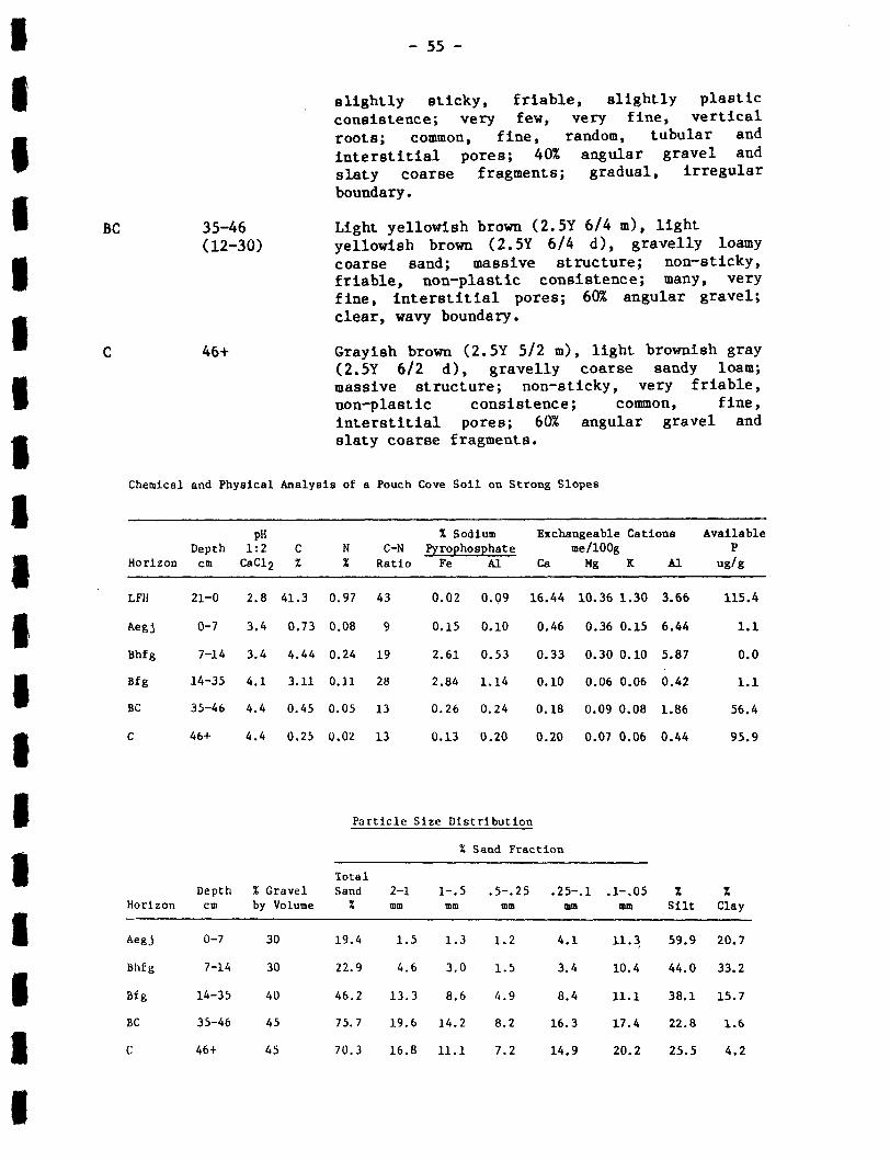
- 55-
slightly sticky, friable, slightly plasticconsistence ; very few, very fine, verticalroots ; common, fine, random, tubular andinterstitial pores ; 40% angular gravel andslaty coarse fragments ; gradual, irregularboundary .
BC
35-46
Light yellowish brown (2 .5Y 6/4 m), light(12-30)
yellowish brown (2 .5Y 6/4 d), gravelly loamycoarse sand ; massive structure ; non-sticky,friable, non-plastic consistence ; many, veryfine, interstitial pores ; 60% angular gravel ;clear, wavy boundary .
C
46+
Grayish brown (2 .5Y 5/2 m), light brownish gray(2 .5Y 6/2 d), gravelly coarse sandy loam ;massive structure ; non-sticky, very friable,non-plastic consistence ; common, fine,interstitial pores ; 60% angular gravel andslaty coarse fragments .
Chemical and Physical Analysis of a Pouch Cove Soil on Strong Slopes
Particle Size Distribution
HorizonDepthcm
pH1 :2CBC12
C%
N%
C-NRatio
% SodiumPyrophosphate
Fe Al
Exchangeable Cationsme/l00g
Ca Mg R Al
AvailableP
ug/g
LFH 21-0 2.8 41 .3 0.97 43 0.02 0 .09 16 .44 10.36 1.30 3.66 115.4
Aegj 0-7 3 .4 0.73 0.08 9 0.15 0 .10 0.46 0 .36 0.15 6 .44 1 .1
Bhfg 7-14 3.4 4 .44 0.24 19 2 .61 0.53 0.33 0.30 0.10 5.87 0.0
Bfg 14-35 4.1 3 .11 0.11 28 2 .84 1 .14 0.10 0.06 0 .06 0 .42 1 .1
BC 35-46 4.4 0.45 0 .05 13 0.26 0.24 0.18 0 .09 0.08 1.86 56 .4
C 46+ 4 .4 0 .25 0 .02 13 0.13 0 .20 0 .20 0.07 0 .06 0.44 95 .9
% Sand Fraction
HorizonDepthcm
% Gravelby Volume
TotalSand%
2-1mm
1- .5mm
.5- .25mm
.25- .1mm
.1- .05mm
%Silt
%Clay
Aegj 0-7 30 19.4 1 .5 1 .3 1 .2 4 .1 11 .3 59.9 20 .7
Bhfg 7-14 30 22.9 4 .6 3 .0 1 .5 3.4 10 .4 44.0 33.2
Bfg 14-35 40 46.2 13 .3 8 .6 4 .9 8.4 11 .1 38.1 15 .7
BC 35-46 45 75.7 19 .6 14.2 8 .2 16 .3 17 .4 22.8 1 .6
C 46+ 45 70 .3 16 .8 11 .1 7 .2 14 .9 20.2 25 .5 4.2

Gleyed Humo-Ferric Podzol .
Soil characteristics
- 5 6-
Pouch Cove Map Unit 2 -- Gently to Moderately Sloping Ridges (165 Ha)
Location
These Pouch Cove soils occupy gentle slopes on low barren ridges and
hummocks and some moderate slopes of more pronounced ridges . These map
units are most common in the southeast portion of the survey area .
Parent Material :
The parent material is a gravelly sandy loam till derived from
slate, arkose and siltstone . The surface is generally very stony and
moderately bouldery .
Topography:
Terrain is generally gently to moderately sloping ; with minor areas
of strong slopes .
Drainage :
Surface drainage and runoff is slow, impeded by a peaty or thick LFH
surface cover and fine textured A and B horizons, over coarse textured
parent material . Internal soil drainage is imperfect to moderate .
Vegetation :
Vegetation cover is a mixture of low wind-pruned black spruce and
larch, with various other species such as sheep laurel, nannyberry,
crowberry, common juniper, blueberry and Labrador tea ; ground
consists of caribou moss, sphagnum, plume moss, step moss, bunchberry,
partridgeberry, starflower and creeping snowberry .
Soil classification :
black
cover
The organic surface cover ranges from 15 to 40 cm in thickness ; the

- 57-
Ae horizon varies from 3 to 12 cm in thickness ; a transitional AB horizon
and a Bhf horizon occur, but are quite variable in thickness and extent ;
the Bf horizon barely meets the podzolic-B thickness requirement tinder
thin organic surface cover, but may be 30 cm thick under thick organic
mounds ; the Bf horizon is usually more mottled and thinner on lower
slopes than upper slopes and crests ; occasionally placic horizons are
encountered in the Bf horizon on sloping terrain; the texure of the Ae
horizon varies from silty clay loam to loam and is occasionally very
gravelly ; the Bf horizon texture ranges from silt loam to loam, with a
variable gravel content ; the surface is very stony and slightly bouldery .
Associated soils
On low barren ridges the Pouch Cove soil occupies the crests and
upper slope with Torbay soil and organic deposits covering lower slopes .
Land use
Poor surface drainage, exposure to wind, stoniness, impermeable
surface horizons and poor soil structure make these map units poor to
unsuitable for vegetable and forage production . These soils could be
developed for rough pasture, which would require less effort in clearing
and maintenance .
Descriptions of two representative profiles :
Soil profiles described are located 150 m northeast of the southeast
corner of Gull Pond on a 6% upper slope at an elevation of approximately
85 m. The profiles describe two sections of a pedon in strongly mounded
terrain (Fig . 11) .
The site is imperfectly drained ; with slow runoff, low
transmissibility and prolonged saturation in organic surface layer and
top 15 cm of mineral soil .
Vegetation cover consists of scrub spruce, larch, sheep laurel,
Amelanchier, northern wild raisin, black crowberry, sweetgale and
Labrador tea . Ground cover on organic mounds is predominantly caribou
moss and woodland mosses ; while depressions are covered by a mixture of
caribou moss and sphagnum .
The ground surface is very stony and slightly bouldery .
- 5 8-
BC
31-40
Pale brown (l0YR 6/3 m), light yellowish brown(7-15)
(2.5Y 6/4 d) gravelly coarse sandy loam ; veryweak, coarse, subangular blocky structure ;
Horizon
LF
Depth cmRange
25-0(15-50)
Description
Dark reddish brown (5YR 2 .5/2 m), slight tomoderately decomposed ericaceous material,woody material, leaves, and mosses ; high fibercontent ; matted ; numerous fine voids ; abundant,coarse, oblique roots ; abrupt, wavy boundary .
Aegj 0-3 Light gray (l0YR 7/2 m, 10YR 7/1 d), gravelly(0 .5-5) silt loam ; common, medium, distinct, light
yellowish brown (l0YR 6/4 m) mottles ; weak,medium to coarse, subangular blocky structure ;sticky, firm, plastic consistence ; abundant,very fine oblique roots ; common, very fine tofine, inped, tubular pores ; 20% gravel andslaty coarse fragments ; gradual, wavy boundary .
Bhf 3-7 Dark brown (7 .5YR 3/2 m), brown (7 .5YR 5/4 d)(0-8) gravelly silt loam ; weak, fine, subangular
blocky structure ; slightly sticky, friable,slightly plastic consistence ; abundant, veryfine, vertical roots ; common, fine, inped andinterstitial pores ; 25% angular gravel ;gradual, irregular boundary .
Bf g 7-31 Strong brown (7 .5YR 5/8 m), brownish yellow(17-33) (l0YR 6/6 d) gravelly silt loam ; few, coarse,
prominent, pale brown (lOYR 6/3 m) mottles ;weak, coarse, subangular blocky structure ;sticky, friable, slightly plastic consistence ;few, very fine, vertical roots ; many, fine,interstitial and inped, tubular pores ; 30%angular gravel ; gradual, wavy boundary .
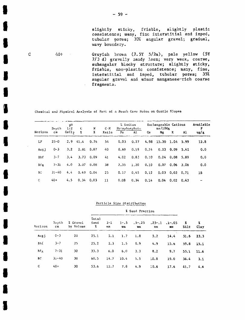
--59-
slightly sticky, friable, slightly plasticconsistence ; many, fine interstitial and inped,tubular pores ; 3GX angular gravel ; gradual,wavy boundary .
C
40+
Grayish brown (2 .5Y 5/2m), pale yellow OY7/3 d) gravelly aandy loan ; very weaK, coarse,subangular blocky structure ; slightly sticky,friable, non-plastic consistence ; many, fine,interstitial and inped, tubular pores ; 35%angular gravel and minor manganese-rich coarsefragments .
Chemical and Physical Analysis of Part of a Pouch Cove Pedon on Gentle Slopes
Particle Size Distribution
HorizonDepthcm
pit1 :2
CaC12C%
LF 25-0 2 .9 41 .4
Aegj 0-3 3 .2 2 .81
Bhf 3-7 3 .4 3.73
Bfg 7-31 4 .0 3.07
BC 33-40 4 .4 0 .49
C 40+ 4 .5 0 .34
N%
C-NRatio
% SodiuwPyrophosphate
PC Al
Exchangeable Cationsme/1008
Ca Mg K Al
AvailableP
Ug/9
0 .76 54 0.03 0 .27 4 .98 15.30 1 .04 5.99 12.8
0 .07 40 0.69 0.19 0 .24 0 .23 0 .09 5 .42 0.0
0.09 41 4 .02 0.83 0.10 0 .24 0.08 5.89 0.0
0 .08 38 2 .35 1 .20 0.10 0 .07 0 .06 3.06 0.0
0.04 25 0 .17 0.45 0.12 0 .03 0.02 0.71 18
0.03 11 0 .08 0 .34 0.14 0 .04 0.02 0.43 -
% Sand Fraction
HorizonDepthcm
% Gravelby Volume
TotalSand
%2-1mm
1-0mm
.5-.25mm
.25- .1mm
.1-.05mm
ZSilt
%Clay
Aegj 0-3 20 25.1 2.1 1 .7 1 .8 5.2 14 .4 51 .6 23 .3
BY 3-7 25 25.2 2 .3 1 .5 0.9 4.9 15 .6 59.8 15.1
Bfiq 7-31 30 33 .3 6.0 6 .0 3 .3 8 .2 9 .7 55.1 11 .6
BC 31-40 30 60.5 14.7 10.4 5.5 10.8 19.0 36 .4 3.1
C 40+ 30 53 .6 12 .7 7 .8 4.9 10.6 17 .6 41 .7 4 .6

O .Om
0 .10M
0 .20m
0 .30m
040m
0.50m
0.60m
0 .7 Om
O .8Om
0 .90m
LOOMFIGURE 11 .
Soil Profile Grow-section ofSloping Terrain .
Pouch Cove Pefn an G-*ntly

cm
Description
Dark reddish brown (5YR 2 .5/2 m) slight tomoderately decomposed mixture of lichen, mossesincluding sphagnum, and ericaceous and woodymaterial ; moderately high fiber content ;matted ; moderately porous ; abundant, medium,oblique roots ; clear, wavy boundary .
Black (5YR 2 .5/1 m) ; organic material composedof mosses with 30% moderately decomposed woodymaterial ; amorphous ; greasy ; moderate fibercontent ; abundant, medium, oblique roots ;abrupt, wavy boundary .
Pinkish gray (7 .5YR 6/2 m), light gray (10YR7/2 d) gravelly loam ; common, medium, distinct,light brown (7 .5YR 6/4 m) mottles ; very weak,coarse, subangular blocky structure ; sticky,firm, plastic consistence ; few, very fine,vertical roots ; few, very fine to fine, inped,tubular pores ; 35% angular gravel and angularcobbles ; gradual, irregular boundary .
Pinkish gray (7 .5YR 6/2 m), light gray (lOYR(1-8)
7/2 d) gravelly clay loam ; many, medium tocoarse, prominent, reddish yellow (7 .5YR 6/8 m)mottles ; very dark gray (5YR 3/1 m) organicrich material in cracks and on ped surfaces ;weak, coarse, subangular blocky structure ;sticky, firm, plastic consistence ; few, veryfine, vertical roots ; few, very fine to fineinped, tubular pores ; 30% angular gravel, andangular cobbles ; gradual, wavy boundary .
Bfgl 9--16(2-10)
clear, wavy boundary .
Bfg2
J_b--26
Strong brown (7 .5YR 5/8 m), brownish yellow(5-19)
(l0YR 6/6 d) gravelly silt loam; few, coarse,prominent, pale brown (IOYR 6/3 m) mottles ;very weak, coarse, subangular blocky structure ;sticky, friable, slightly plastic consistence ;
Hori2;crb Depth(Range
LF 15-1(12,-20)
H 1A(0-3)
Aegj 0-4(1-6)
ABg 4-_.9
Very d4/1 d)
rk gray (5YR 3/1 m), dark gray (5YRgravelly silt loam, with pinkish gray
(7 .5YRinteriors ;yellowsubangular
6/2 m) to brown (7 .5YR 5/2common, medium, prominent
(7 .5YR 6/8 m) mottles ; weak,blocky structure ; sticky,
m) pedreddishcoarse,
firm,plastic consistence ; very few, very fine,vertical roots ; common, very fine to fine,inped, tubular pores ; 35% angular gravel ;

- 62-
very few, very fine, vertical roots ; many,fine, interstitial, and inped, tubular pores ;30% angular gravel ; gradual, wavy boundary .
BC
26-38
Pale brown (l0YR 6/3 m), light yellowish brown(9-15)
(2 .5Y 6/4 d), gravelly coarse sandy loam ; veryweak, coarse, subangular blocky structure ;slightly sticky friable, slightly plasticconsistence ; many, fine, interstitial, andinped, tubular pores ; 30% angular. gravel ;gradual, wavy boundary .
C
38+
Grayish brown (2 .5Y 5/2 m), pale yellow (5Y7/3 d) gravelly fine sandy loam ; very weak,coarse, subangular blocky structure ; slightlysticky, friable non-plastic consistence ; many,fine, interstitial and inped, tubular pores ;35% angular gravel and minor manganese-richcoarse fragments .
Chemical and Physical Analysis of Part of a Pouch Cove Pedon on Gentle Slopes
Particle Size Distribution
HorizonDepthcm
pH1 :2CaC12
C%
N%
C-NRatio
% SodiumPyrophosphate
Fe Al
Exchangeable Cationsme/l00g
Ca Mg K Al
AvailableP
ug/g
LF 15-1 3 .0 43.3 0.94 46 0 .01 0.14 17.04 18.30 1 .11 3.66 11 .7
H 1-0 2 .9 41 .9 0 .76 55 0.15 0 .98 2 .76 2 .47 0 .49 15 .65 99 .6
Aegj 0-4 3.4 0.95 0 .07 14 0 .23 0.13 0.25 0.23 0 .09 6.89 1 .1
ABg 4-9 3 .2 1 .67 0 .11 15 1 .14 0.22 0.17 0.21 0 .08 6.20 0.0
Bfgl 9-16 3 .6 4.81 0 .24 20 0 .46 0.72 0.16 0 .16 0.09 7 .31 3.8
Bfg2 16-26 4 .0 3.07 0 .08 38 2 .35 1 .20 0.10 0 .07 0 .06 3 .06 0 .0
BC 26-38 4.4 0.49 0 .04 25 0.17 0.45 0.12 0 .03 0.02 0 .71 18
C 38+ 4 .5 0.34 0 .34 11 0 .08 0 .34 0.14 0 .04 0.02 0 .43
HorizonDepthcm
% Gravelby Volume
TotalSand
%2-1mm
%
1- .5mm
Sand Fraction
.5-.25 .25-.1mm mm
.1-.05mm .
% _Silt
%Clay
Aegj 0-4 35 27 .4 0 .8 1 .3 1 .3 7 .3 16 .7 49 .4 23.2
ABg 4-9 25 20.5 0.8 0.8 0.6 5.6 12.8 43.9 35.5
Bfgl 9-16 30 25 .6 3.5 2.8 1 .0 5 .3 13.0 73.1 1 .3
Bfg2 16-26 30 33.3 6 .0 6 .0 3 .3 8.2 9.7 55.1 11 .6
BC 26-38 30 60 .5 14 .7 10.4 5.5 10.8 19.0 36 .4 3 .1
C 38+ 30 53.6 12 .7 7 .8 4.9 10.6 17 .6 41 .7 4 .6

Torbay Map Unit (10 Ha)
Location :
63
Torbay soils occur in depressicna and Loa slopes of ridges and
hummocks throughout the survey area .
Parent Material:
The parent material consists of 5 to 30 cm of silt loam to sandy
clay loam over loam to gravelly sandy loam till, derived from slate,
arkose and siltstone . The ground surface is generally very to
exceedingly stony and slightly bouldery .
Topography :
Torbay soils are found on toe slopes of ridges and gently to
moderately inclined depressional terrain.
Drainage :
Drainage ranges from poor to very poor, with prolonged periods of
saturation . Drainage is impeded by a peaty surface layer, fine surface
textures in the mineral soil, and slow to very slow runoff .
Vegetation :
Vegetation cover is usually unproductive growth of black spruce,
balsam fir larch, and various species of shrubs. Ground vegetation is
composed of a vigorous growth of woodland and bogland mosses, sedge,
lichen and numerous flowering species .
Soil classification :
Rego Gleysol (peaty phase) .
Soil characteristics :
The organic cover ranges from 10 to 60 cm in thickness and is
variable in composition ; the degree of development of mineral horizons is
quite variable - a thin Ah is sometimes presents an Aeg is common and

- 64-
ranges from 3 to 10 cm thick ; Orthic Gleysols and Humic Gleysols occur as
inclusions ; texture of the top 10 to 20 cm is commonly silty clay loam,
over a very gravelly parent material ranging from silt loam to sandy
loam ; surface stoniness ranges from very stony to excessively stony .
Associated soils :
On ridged terrain the Torbay soil occupies lower slopes below
Markland and Pouch Cove soils, and grades into organic soils in
depressions . On gently inclined and depressional terrain, the Torbay
soils are closely intermixed with wooded fens . These two soils are
commonly mapped together as compound map units .
Land use :
The Torbay soil is unsuitable for agriculture . Very poor drainage
and stoniness are the major limitations .
Description of -a representative profile :
Soil profile described is located 200 m northeast of the Markland
and Nuggetville Road junction on a. 3% slope at an elevation of
approximately 50 m .
The parent material is a very gravelly loam till derived from slate,
arkose and siltstone .
The site is very poorly drained, with slow runoff .
Vegetation cover consists of scrub growth black spruce, larch and
balsam fir ; as well as a variety of shrubs such as nannyberry, sheep
laurel, bog laurel and blueberry . Ground cover consists of sphagnum,
sedge, caribou moss, rushes, black cranberry, creeping snowberry, large
cranberry, twinflower, f iddlehead fern, corn lily and bakeapple .
The ground surface is very stony .
- 65-
non-plastic consistence ; moderately porous ; 60%angular gravel and slaty coarse fragments .
Horizon Depth cm(Range)
Description
Of 17-7 Yellowish brown (l0YR 5/4 m) ; organic material(5-18) composed of predominantly mosses including
sphagnum, with significant woody and ericaceousmaterial, and minor leaves, needles and twigs ;f ibric, non-greasy, wet ; plentiful, coarse andmedium, horizontal roots ; gradual, wavyboundary .
Om-Oh 7-0 Dark grayish brown (l0YR 4/2 m) to black (l0YR(4-10) 2 .5/1 m), moderately to strongly decomposed
organic material ; moderate fiber content,including slightly decomposed woody material ;greasy, saturated ; plentiful, coarse and medium,horizontal roots ; clear, wavy boundary .
Ah 0-4 Pale brown (l0YR 6/3 m) to brown (l0YR 5/3 m),(2-7) light brownish gray (l0YR 6/2 d), silty clay
loam ; massive structure ; sticky, friable,plastic consistence ; plentiful, fine, randomroots ; slightly porous ; 2% angular gravel ;gradual, wavy boundary .
Ae g 4-7 Light gray (l0YR 7/2 m, 10YR 7/1 d), silty clay(2-7) loam ; few, fine, prominent reddish yellow
(7 .5YR 6/8 m) mottles ; massive structure ;sticky, firm, plastic consistence ; plentiful,fine, random roots ; slightly porous, 2% angulargravel ; clear, wavy boundary .
Cgl 7-17 Gray (5Y 5/1 m), light gray (5Y 6/1 d), silty(6-14) clay loam ; few, fine, prominent reddish yellow
(7 .5YR 6/8 m) mottles ; massive structure ;sticky, friable, plastic consistence ;moderately porous ; 15% angular gravel ; abrupt,wavy boundary .
Cg2 17+ Olive gray (5Y 4/2 m), light olive gray (5Y6/2 d), very gravelly loam ; few, coarse,prominent brownish yellow (lOYR 6/6 m) mottles ;massive structure ; non-sticky, very friable,
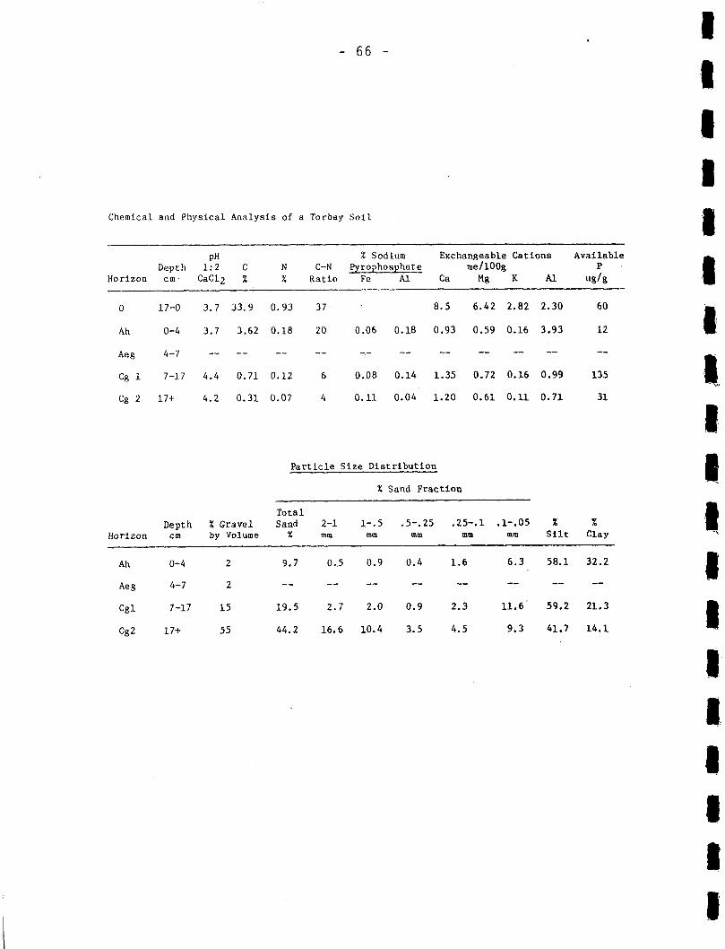
Chemical and Physical Analysis of a Torbay Soil
Particle Size Distribution
HorizonDepthcm
pH1 :2CaC12
C%
N%
C-NRatio
%
Fe
SodiumPyrophoaphate
A1
Exchangeableme/l00g
Ca Mg
Cations
K Al
AvailableP
ug/g
0 17-0 3 .7 33.9 0.93 37 - 8.5 6.42 2 .82 2.30 60
Ah 0-4 3 .7 3 .62 0 .18 20 0 .06 0.18 0 .93 0 .59 0 .16 3 .93 12
Aeg 4-7 -- -- -- -- - -- -- -- -- -- --
Cg 1 7-17 4 .4 0.71 0.12 6 0 .08 0 .14 1 .35 0.72 0.16 0 .99 135
Cg 2 17+ 4.2 0 .31 0.07 4 0 .11 0.04 1 .20 0.61 0 .11 0.71 31
% Sand Fraction
HorizonDepthcm
% Gravelby Volume
TotalSand
%2-1mm
1- .5mm
.5-.25mm
.25-.1mm
.1- .05mm
%Silt
%Clay
Ah 0-4 2 9.7 0 .5 0.9 0 .4 1 .6 6 .3 58.1 32 .2
Aeg 4-7 2 -- -- -- -- -- -- -- --
Cgl 7-17 15 19 .5 2 .7 2 .0 0.9 2.3 11 .6" 59 .2 21 .3
Cg2 17+ 55 44.2 16 .6 10.4 3.5 4.5 9.3 41 .7 14.1
- 67-
Torbay- _- Wooded Slope Fen Map Unit (25 Ha)
This map unit is composed predominantly of very poorly drained,
peaty phase Torbay soils, with a significant proportion of wooded slope
fen soils . Both soils occur in depressions, with the Torbay soil
occurring on slight rises in the mineral terrain.. The most significant
difference in the two component soils is the depth of organic material .
It is less than 40 cm for the Torbay soil and between 40 and 160 cm for
the wooded slope fens . Both these soils are described in more detail as
individual map units .
ORGANIC SOILS
Organic Map Unit 1 -- Domed Bog (585 Ha)
Location :
Domed bogs are common in depressions throughout the survey area .
Parent Material :
These soils have developed from the growth and decomposition of
predominantly sphagnum moss and sedge .
T9pography :
The map units are domed with very gentle slopes except around of
the perimeter where slope breaks may be quite sharp .
Drainage :
The soils are very poorly drained, though the water table may
drop below the surface layer for extended periods during the summer .
Pools occupy up to 10% of surface area .

Vegetation :
The vegetation cover
sedge and caribou moss . On
black spruce and larch occur .
Soil classification :
Typic Mesisol
Range of characteristics :
- 68 -
is composed predominantly of sphagnum moss,
small hummocks, ericaceous shrubs and scrub
Thickness and stage of decomposition of the different organic
layers is highly variable . Deposit thicknesses range from 2 to 5 m .
Associated soils :
These soils are mapped singly, but may contain inclusions of
other organic soils .
Land use :
These soils are fair to poor for agriculture, as a source of
horticultural peat, and for fuel peat ; and good for use in composts .
Limitations for agricultural development include : presence of open
water, significant sedge component in the soil matrix, and variable
decomposition .
Description of a representative profile :
Soil profile described is located 0 .6 km southeast of Brazil's
Pond, on a bog crest, at an elevation of approximately 60 m .
These soils are developed from the growth and decomposition of
predominantly sphagnum moss and sedge .
The site is very poorly drained, though the water table drops
below the surface layer for extended periods during the summer .
Surface vegetation consists of a mixture of sphagnum moss, sedge
and caribou moss ; with minor scrub larch, scrub black spruce, bog laurel,
Labrador tea, black crowberry, bakeapple and pitcher plant .
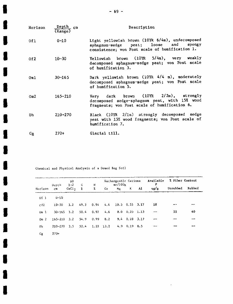
cm
Light yellowish brown (lOYR 6/4m), undecomposedsphagnum-sedge peat ; loose and spongyconsistence ; von Post scale of humification 1 .
Yellowish brown (lOYR 5/4m), very weaklydecomposed sphagnum-sedge peat ; von Post scaleof humification 3 .
Dark yellowish brown (IOYR 4/4 m), moderatelydecomposed sphagnum-sedge peat ; von Post scaleof humification 5 .
Very dark brown (IOYR 2/2m), stronglydecomposed sedge--sphagnum peat, with 15% woodfragments ; von Post scale of humification 6 .
Black (10YR 2/1m) strongly decomposed sedgepeat with 15;6 wood fragments ; von Post scale ofhumification 7.
Glacial till .
Chemical and Physical Analysis of a Domed Bog Soil
Description
HorizonDepthCm
pH1 :2
CsC12C%
N%
Exchangeableme/100K
Ca Mg
Canons
K A1
AvailableP
ug/g
% Fiber
Unrubbed
Content
Rubbed
Of 1 0-10
Uf2 10-30 3 .2 49 .3 0.94 4 .4 10.5 0.55 3 .17 18 -- --
OM 1 30-165 3 .2 50 .4 0 .92 4 .6 8 .0 0 .23 1 .13 -- 55 . 40
Om 2 165-210 3 .2 54 .9 0.99 8.2 9.4 0.28 3 .17 -- -- --
Oh 210-270 3 .5 52 .4 1 .22 13 .2 4 .9 0 .19 8.5 -- -- --
Cg 270+
Horizon Depth(Range-)
Ofl 0-10
Of2 10-30
Oml 30-165
Om2 165-210
Oh 210-270
Cg 270+

Organic Map Unit 2 - Slope Bog (290 Ha)
Location:
Slope bogs are common in depressions throughout the survey area .
Parent Material :
These soils have developed from the growth and decomposition of
sphagnum mosses and sedges .
Topography:
The deposits are characterized by long, unidirectional gentle slopes .
Drainage :
The soils are very poorly drained, though the water table may drop
below the surface layer for extended periods during the summer .
Vegetation :
The vegetation cover is predominantly sedge and sphagnum moss, with
caribou moss, ericaceous shrubs, and scrub larch and black spruce .
Soil classification :
Typic Mesisol .
Range_of -characteristics :
- 70-
range from 1 .5 to 4 Fibric and humicDeposit thicknesses
horizons may be found in some control sections . The amount of sedge in
the control section is variable from site to site, but is usually less
common than sphagnum moss . Minor amounts of wood may be present in lower
horizons .
Associated soils :
These soils occur as simple map units only ; but may contain
inclusions of other organic and poorly drained mineral soils .

Land use :
These soils are fair to poor for agriculture, as a source of
horticulture peat, and for fuel peat ; and good for use in composts .
Limitations for agricultural development include : a significant sedge
component in the soil matrix and strongly decomposed layers near the
surface .
Description of a representative profile :
Soil profile described is located 0 .7 km north of the Markland and
Nuggetville Road intersection on a 3% slope at an elevation of
approximately 65 m.
The soils are developed from the growth and decomposition of
sphagnum moss and sedge .
The site described is very poorly drained, though the water table
drops below the surface layer for extended periods during the summer .
Surface vegetation consists of a mixture of sphagnum moss, sedge and
caribou moss ; with minor scrub larch and spruce, bog laurel, black
crowberry, goldenrod and pitcher plant .
Horizon De th-C
cm Descriptionange
Of1 0-10 Yellowish brown, very weakly decomposedsphagnum peat ; loose and spongy consistence ;von Post scale of humification 3 .
Of2 10-20 Yellowish brown, weakly decomposedsphagnum-sedge peat ; von Post scale ofhumification 4.
Oml 20--140 Brown, strongly decomposed sphagnum-sedge peat ;von Post scale of humification 6.
Oh 140-230 Yellowish brown, strongly decomposedsphagnum-sedge peat ; von Post scale ofhumification 7.
- 72-
Chemical and Physical Analysis of a Slope Bog Soil
d
Organic Map Unit 3 - Slope Fen ( 70 Ha)
Location :
Slope fens occupy depressional areas throughout the survey area.
Parent Material :
These soils have developed from the growth and decomposition of
sedges and sphagnum mosses .
Topography
The deposits are characterized by unidirectional gentle slopes .
Drainage :
The soils are very poorly drained with surface water apparent
throughout the summer . Surface seepage from adjacent mineral soils is
common.
HorizonDepthcm
pH1 :2
CaC12C%
N%
Exchangeableme/1OOg
Cia Mg
Cations
K Al
AvailableP
ug/g
% Fiber Content
Unrubbed Rubb
Ofl 0-10 3 .2 44 .1 3 .03 7 .9 13 .8 2.19 2 .5 78
Of2 10-20 3 .6 -- -- 7 .7 1.4 .8 0.71 14 .2 -- 90 80
Oml 20-120 3 .1 45 .9 0.73 6 .6 15.4 0.18 1 .9 3
Oh 120-230 3 .1 50 .4 0.55 7 .5 13 .3 0 .23 1 .73 --
Om2 230-320 3.2 44.3 0.64 9 .0 7.9 0.06 0.97 --
Om3 320-390 3.6 53 .1 1.52 19.1 5.9 0.07 1 .20 --
Cg 390+
Om2 230-320 Reddish brown, moderately decomposed sedge-spahnum peat ; von Post scale of humification 5 .
Om3 320-390 Reddish brown, moderately decomposedsedge-sphagnum peat, with 20% wood fragments ;von Post scale of humification 5 .
Cg 390+ Glacial till .

Vegetation :
- 7 3-
The vegetation is predominantly sedge with sphagnum moss, and minor
caribou moss, scrub spruce and larch, ericaceous species, blue-eyed
grass, pitcher plant, horsetail, goldenrod, northeastern rose, northern
wild raisin, rushes, and broad-leaved sundew.
Soil classification :
Terric Mesisol .
Range of characteristics :
The thickness and stage of decomposition of the different organic
layers is highly variable . Deposit thickness usually ranges from 1 to 2
m.
Associated soils :
These soils are mapped singly but may include intergrades of other
organic soils such as slope bogs and floating fens .
Land use :
Excess surface water, stage of decomposition, and composition make
these soils unsuitable for agricultural development and as sources for
horticultural peat, fuel peat, and compost material .
Description .of a representative profile :
Soil profile described is located 250 m east of the Markland and
Nuggetville Road intersection on a 2% slope at an elevation of
approximately 50 m .
The soil is developed from the growth and decomposition of sedge and
sphagnum moss .
The soil is very poorly drained, with the water table at or near the
surface throughout the year .
Surface vegetation is predominantly sedge ; with sphagnum moss and
minor caribou moss, scrub spruce and larch, and ericaceous shrubs .

Chemical and Physical Analysis of a Slope Fen Soil
pH
Exchangeable Cations
Available
% Fiber ContentDepth 1 :2 C N me/l00g
PHorizon cm CaC12 % % Ca Mg K Al ug/g Unrubbed Rubbed
Of 0-15 _- _- _- _- _- -_ -- __
Om
15-100 3 .2 56 .1 1 .04 14 .4 9.87 0.67 3 .57 20
Oh 100-110 -- -- -- -- -- -- --
--
Cg 110+
Organic Map_ Unit 4 -- Wooded Slope Fen (625 Ha)
Location :
Wooded slope fens are common in depressions throughout the survey
area .
Parent Material :
These soils have developed from the growth and decomposition of
woody plants and woodland mosses, over sphagnum mosses and sedges .
- 74 -
Horizon Deth cm Description(Rang)e
Of 0-15 Light yellowish brown, almost undecomposedsphagnum-sedge peat ; loose, spongy consistence ;von Post scale of humification 2 .
OM 15-100 Brown, strongly decomposed sedge-sphagnum peat ;von Post scale of humification 6 .
Oh 100-110 Dark brown, strongly decomposed sedge-sphagnumpeat, with 20% wood fragments ; von Post scaleof humification 7 .
Cg 110+ Glacial till .
Topo&raphy
These areas are characterized by very gentle slopes .
Drainage_ :
The soils are poorly to very poorly drained, with surface water
common under open scrub conditions . Under dense tree cover the water
table may remain below the surface layer throughout the summer .
Vegetation :
Vegetation ranges from a dense cover of black spruce and balsam fir
minor sphagnum moss, to open
ground cover of sedge, sphagnum moss
with a ground cover of
scrub black spruce and larch with a
and ericaceous shrubs .
Soil classification :
Terric Fibric Humisol .
Range of characteristics :
woodland mosses and
thickness and nature of
- 75-
decompostion of the different organicThe
layers is highly variable . Woody material may
matrix. Deposit thickness usually ranges from 0.6 to 2 .0 m .
Associated soils :
occur throughout the
These soils are often mapped with peaty phase Torbay soils occuring
on the same terrain . Organic cover thickness is often the only
distinguishing factor .
Land use :
Vegetation cover,
these soils unsuitable for agriculture,
or fuel peat and compost material.
stage of decomposition, and wood content make
and as sources for horticultural,

Description of a representative profile :
Soil profile described is located 0 .6 km southeast of the Markland
bridge on a 2% slope at an elevation of approximately 50 m .
The soil is developed from the growth and decomposition of woodland
mosses, over strongly decomposed sphagnum moss and sedge .
The soil is poorly drained, with the water table below the surface
layer throughout the summer .
Vegetation cover consists of unproductive black spruce and minor
balsam fir . Ground cover is composed of step moss, plume moss and
scattered bunchberry, snowberry, large and small
Amelanchier .
- 7 6-
Description
Brown, undecomposed feather moss peat, withminor sphagnum, sedge and wood ; von Post scaleof humification 1 .
Dark brown, very weakly decomposed feather mosspeat, with minor sphagnum, sedge and wood ; vonPost scale of humification 3 .
Black, strongly decomposed sphagnum-sedge peat ;von Post scale of humification 7 .
Black, strongly decomposed sedge-sphagnum peat ;von Post scale of humification 7 .
Glacial till .
sphagnum moss, with
cranberry, sedge and
Horizon Depth cm(Range)
Ofl 0-20
Of2 20-35
Ohl 35-50
Oh2 50-100
Cg 100+

- 77-
Chemical and Physical Analysis of a Wooded Slope Fen Soil
% Fiber Content
Unrubbed Rubbed
Wooded Slope Fen - Torbay Map Unit (970 Ha)
This map unit is composed of predominantly very poorly drained
wooded slope fen soils, with a significant proportion of very poorly
drained, peaty phase Torbay soils . Both soils occur in depressions in
hummocky till terrain, with the Torbay soil occurring on slight rises in
the mineral terrain . The most signficant difference in the two component
soils is the depth of the organic material . It is between 40 and 160 cm
for the wooded slope fen and less than 40 cm for the Torbay soil . This
range in organic surface thickness is usually quite variable over short
distances . Both these soils are described in more detail as individual
map units .
Organic Map Unit 5 - Horizontal Marsh (40 Ha)
Location :
Horizontal marshes occur primarily in the central portion of the
survey area along the shores of streams and ponds .
HorizonDepthcm
pH1 .2
CaC12C%
N%
Exchangeabme/lOOg
Ca Mg
e Cations
K Al
AvailableP
ug/g
Ofl 0-20 3.3 44 .8 0 .87 11 .3 8.3 1 .62 2 .10 115
Of2 20-35 3 .2 46 .3 1 .07 14 .9 10 .3 0.56 2 .33 145
Ohl 35-50 3 .2 39.4 0 .86 9 .6 4 .2 0 .18 3 .63 --
Oh2 50-100 3 .4 43.7 1 .44 8 .8 3 .5 0 .32 3 .60 --
Cg 100+ 3.9 2 .49 0.13 1 .5 0.8 0.06 1 .99 --

Parent Material :
_78_
These soils have developed from the growth and decomposition of
sedges and aquatic plants .
Topography :
Surface form is flat .
Drainage
The soils are very poorly drained with the water table at or near
the surface throughout the summer . Some of these soils are often
inundated due to fluctuating pond and stream levels .
Vegetation :
Vegetation is predominantly sedge with scattered
horsetail, sweetgale, iris, northeastern rose and larch.
Soil classification :
cat-tail, rushes,
Typic Humisol.
Range of characteristics :
The thickness and nature of decomposition of the different
layers and occurrence of mineral layers are highly variable .
thickness varies from 3 to 6 m .
Associated soils :
organic
Deposit
These soils are mapped individually but may have inclusions of other
organic soils . The soil is usually proximal to other organic soils or
very poorly drained mineral soils .
Land use :
Stage of decomposition and a wet unstable surface make these soils
unsuitable for agriculture, and as a source for horticultural peat, fuel
peat, and compost material .
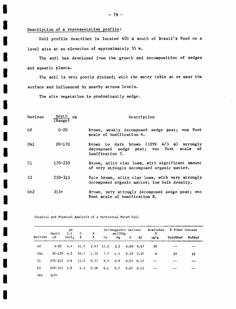
- 79-
Description of a representative profile :
Soil profile described is located 400 m south of Brazil's Pond on a
level site at an elevation of approximately 55 m .
The soil has developed from the growth and decomposition of sedges
and aquatic plants .
The soil is very poorly drained ; with the water table at or near the
surface and influenced by nearby stream levels .
The site vegetation is predominantly sedge .
Chemical and Physical Analysis of a Horizontal Marsh Soil
HorizonDepthcm
pH1 :2CaC12
C%
N%
Exrhangeableme/1008
Ca Mg
Cations
K Al
AvailableP
ug/g
% Fiber
Unrubbed
Content
Rubbed
Of 0-20 4 .4 41 .S 2 .43 15 .2 3.2 0.68 0 .67 39 -- --
Ohl 20-170 4 .2 33 .7 1 .72 7 .5 1 .1 0.19 2 .47 6 25 15
Cl 170-215 5.6 11 .5 0 .77 9.5 0 .9 0.05 0 .17 -- -- --
C2 250-315 5 .9 4 .3 0 .28 6.1 0 .7 0 .07 0.13 -- -- --
Oh2 315+
Horizon De th cm DescriptionRange
Of 0-20 Brown, weakly decomposed sedge peat ; von Postscale of humification 4 .
Ohl 20-170 Brown to dark brown (l0YR 4/3 m) stronglydecomposed sedge peat ; von Post scale ofhumification 7 .
C1 170-250 Brown, silty clay loam, with significant amountof very strongly decomposed organic matter .
C2 250-315 Pale brown, silty clay loam, with very stronglydecomposed organic matter ; low bulk density .
Oh2 315+ Brown, very strongly decomposed sedge peat ; vonPost scale of humification 8 .

- 80-
Selected Bibliography
Agriculture Canada .
1976 .
Manual on soil sampling and methods ofanalysis . Soil Research Institute, Ottawa, Ont . 94 pp .
Banfield, C.E. 1981 . The climatic environment of Newfoundland in : Thenatural environment of Newfoundland, past and present . A.G .MacPherson and J .B . MacPherson (eds .) . Dept . of Geography, MemorialUniversity of Newfoundland . 265 pp .
Canada Department of Agriculture .
1977 . Growing degree days and cropproduction in Canada . Publ . 1635. 63 pp .
Canada Soil Survey Committee, Subcommittee on Soil Classification . 1978.The Canadian system of soil classification . Can . Dept . Agric .Publ . 1646 . Supply and Services Canada, Ottawa, Ont . 164 pp .
Delaney, B.B ., Cahill, M.J. and Chow, T .L . 1984 .
Vegetation and micro-climate relationships on a forested ribbed moraine in EasternNewfoundland . Dept . Forest Resources and Lands, St . John's, Nfld .Unpublished.
Delaney, B .B . ; Cahill, M .J . 1978.
A pattern of forest types on ribbedmoraines on the Avalon Peninsula . Can. J . For . Res ., 8 :116-120 .
Dept . Forest Resources and Lands, Province of Newfoundland and Labrador .1980 . Peatland inventory, Eastern Newfoundland (prepared . byNorthland Associates Ltd .) .
Dumansky, J. (ed .) 1978 .
The Canada soil information system (CanSIS) .manual for describing soils in the field . Land Resources ResearchInstitute, Agric . Can ., Ottawa .
Dzikowski, P .A. et . al . 1984 .
The Climate for agriculture in AtlanticCanada . Prepared for the Atlantic Advisory Committee onAgrometeorology .
Publication No . ACA 84-2-500 .
Emerson, F . et . al. 1934 . Interim report on Markland . 1934 .
Glossary of terms in soil science . 1976 . Agric . Can. Pub1 . 1459, Ottawa .44 pp .
Hanley, J .A . 1940 . Second report (1939) on the development of agricul-ture and land settlements in Newfoundland . Dept . of Agriculture andRural Reconstruction, St . John's .
Henderson, E .P . 1972. Surficial geology of the Avalon Peninsula,Newfoundland . G.S .C . Memoir 368, Ottawa, Ont . 121 pp .

- 81 -
Heringa, P .K. 1981 . Soils of the Avalon Peninsula, Newfoundland . LandResource Research Institute, Publication 113, Agriculture Canada,Ottawa .
Kirby, G .E .
Soils of the Pasadena-Deer Lake area, Newfoundland . 1984
Report No . 17, Newfoundland Soil Survey, Soil and Land ManagementDivision, Dept . of Rural, Agricultural and Northern Development .Unpublished .
Kirby, F.T., Ricketts, R .J . ; Vanderveer, D .G . 1983 . Inventory of aggregateresources in Newfoundland and Labrador, information report and indexmaps . To Accompany Aggregate Resources Map Series, 1 :250,000 (OpenFiles Newfoundland 1287 and Labrador 602), Report 83-2, Dept . Minesand Energy, St . John's, Nfld . 36 pp .
Kirby, F .T . 1978 . Provisional aggregate resources inventory maps for 1N5and 1N6 . Dept . of Mines and Energy .
Mapping Systems Working Group . 1981 .
A soil mapping system for Canada :revised . Land Resource Research Institute, Contribution No . 142,Agriculture Canada, Ottawa, Ont . 94 pp .
McCartney, W .D . 1967 . Whitbourne Map Area, Newfoundland . GSC Memoir 341 .Department of Energy, Mines and Resources, Ottawa .
McKeague, J .A. ed ., 1981 . Manual on soil sampling and methods of analysis .Can. Soc . Soil Sci . 212 pp .
Meaney, B . 1984 . Biological operation of the St . Mary's Bay North salmonenhancement project . Salmon Enhancement Association ofNewfoundland, St . John's . Unpublished .
Newfoundland Forest Service .
Forest Capability, Argentia (E) . 1 :50,000Map by Dept . of Mines, Agriculture and Resources, St . John's, 1968 .
Newfoundland Forest Service .
Forest Capability, Holyrood (W) . 1 :50,000Map by Dept . of Mines, Agriculture and Resources, St . John's, 1968 .
Rogerson, R .J . ; Tucker, C .M . 1972 .
Observations on the glacial historyof the Avalon Peninsula . Mar. Sed ., 8 :25-31 .
Rowe, J .S . 1959 . Forest regions of Canada, Bull . 1R3 . Dept . of NorthernAffairs and National Resources, Ottawa, Ont . 71 pp .
Summers, W .F . 1949 . The physical geography of the Avalon Peninsula . MScThesis, Dept . of Geography, McGill University, Montreal.
Vanderveer, D.G. 1975 . Surficial Geology of Argentia Map Sheet 1N5 .1 :50,000 Scale Map . Dept . of Mines and Energy, Open File 960 .

COMMON AND BOTANICAL NAMES OF PLANTS
- 82-
Common Name Latin Name
Amelanchier or chuckleberry Amelanchier spp .
bakeapple Rubus chamaemorus L .
balsam fir Abies balsamea (L .) Mill .
black crowberry Empetrum nigrum L .
black spruce Picea mariana (Mill .) B .S .P .
blueberry Vaccinium angustifolium Ait .
blue-eyed grass Sisyrinchium spp .
bog aster Aster nemoralis Ait .
bog laurel Kalmia polifolia Wang .
bulrush Scirpus spp .
bunchberry Cornus canadensis L .
Canadian yew Taxus canadensis Marsh
carer Carex app .
caribou moss or lichen Cladonia spp .
cat-tail Typha latifolia L .
choke cherry Prunus virginiana L .
clintonia or corn lily Clintonia borealis
clubmoss Lycopodium spp .
common buttercup Ranunculis acris
common juniper Juniperus communis L .
creeping saowberry Gaultheria hispidula (L .) Bigel .
Eriophorum Eriophorum spp .

-83-
feather moss Pleurozium schreberi
fern Dryopteris spp .
fireweed Epilobium angustifolium L.
goldenrod Solidago spp .
heather Calluna vulgaris (L .) Hull
horned bladderworth Utricularia cornuta Michx .
horsetail Equisetum spp .
Indian pipe Monotropa uniflora L .
Iris or blue flag Iris versicolor L .
Labrador tea Ledum groenlandicum Oeder
larch or tamarack Larix laricinia (Du Roi) K . Koch
large cranberry Vaccinium macrocarpon Ait .
leafy white orchis Habenaria dilatata (Pursh.) Hook .
leather leaf Chamaedaphne calyculata (L.) Moench
marsh blue violet Viola cucullata
meadowsweet Spirea latifolia (Ait .) Borkh .
mountain ash or dogberry Sorbus americana Marsh.
mountain maple Acer spicatum Lam.
northeastern rose Rosa nitida Willd .
northern honeysuckle Lonicera villosa (Michx .) R. & S .
northern wild raisin or nannyberry Viburnum cassinoides L .
partridgeberry Vaccinium vitis - idaea L .
pin cherry Prunus pensylvanica L.f .
pitcher plant Sarracenia purpurea L.
plume moss Ptilium crista - castrensis (Hedw.) D .Not

raspberry
rattlesnake plantain
red-osier . dogwood
rough-leaved aster
round-leaved orchis
round-leaved sundew
rush
Scirpus
shaggy moss
sheep laurel or lambkill
small cranberry
speckled alder
sphagnum moss
starflower
step moss
strawberry
swamp saxifrage
sweetgale or bog-myrtle
tall meadow-rue
three-leaved false Solomon's-Seal
trembling aspen
twinflower
white. birch
willow
yellow avens
- 84-
Rubus idaeus L .
Goodyera repens
Cornus stolonifera Michx .
Aster radula Ait .
Habenaria orbiculata
Drosera rotundifolia L.
Juncus spp .
Scirpus spp .
Rhytidiadelphus triquetris (Hedw.) Warnst .
Kalmia angustifolia L.
Vaccinium oxycoccus L .
Alnus rugosa (Du Roi) Spring .
Sphagnum spp .
Trientalis borealis
Hylocomium splendens (hedw .) B .S .G .
Fragaria virginiana Duchense
Saxifraga pensylvanica
Myrica gale L .
Thalictrum polygamum Muhl .
Smilacina trifolia
Populus tremuloides Michx .
Linnaea borealis L .
Betula papyrifera Marsh .
Salix spp .
Geum aleppicum Jacq .