يناطيللا رهن ضوح ةرادإ معد جمانرب river... · litani river walk-through...
TRANSCRIPT
1122تشرين األول
وقد أعدته شركة مجموعة الموارد . (USAID)تم تحضير هذا التقرير للمراجعة من قبل الوكالة األمريكبة للتنمية الدولية
.EPP-I-00-04-00024-00 order no 7: بموجب العقد (IRG)الدولية
برنامج دعم إدارة حوض نهر الليطاني
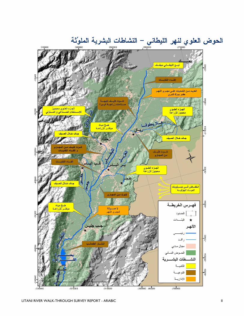
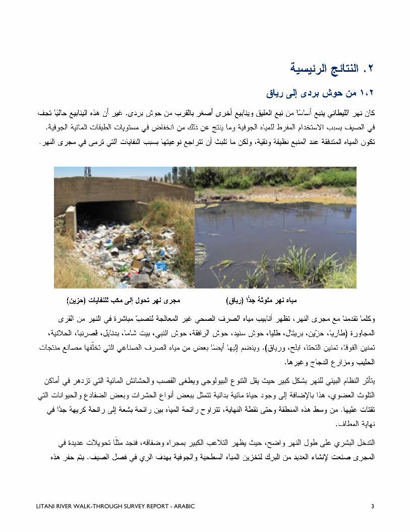
سيرًا على األقدام، على ضفاف نهر الليطاني

EPP-I-00-04-00024-00 order no 7
هي من مسؤولية واضعها وال تعكس بالضرورة وجهة نظر الوكالة االميركية إن االفكار الواردة في هذا التقرير :مالحظة
.للتنمية الدولية او حكومة الواليات المتحدة االميركية


LITANI RIVER WALK-THROUGH SURVEY REPORT - ARABIC I
LITANI RIVER WALK-THROUGH SURVEY REPORT - ARABIC II
LITANI RIVER WALK-THROUGH SURVEY REPORT - ARABIC 1
o
o

LITANI RIVER WALK-THROUGH SURVEY REPORT - ARABIC 2
LITANI RIVER WALK-THROUGH SURVEY REPORT - ARABIC 3
LITANI RIVER WALK-THROUGH SURVEY REPORT - ARABIC 4
LITANI RIVER WALK-THROUGH SURVEY REPORT - ARABIC 5
LITANI RIVER WALK-THROUGH SURVEY REPORT - ARABIC 6
LITANI RIVER WALK-THROUGH SURVEY REPORT - ARABIC 7
LITANI RIVER WALK-THROUGH SURVEY REPORT - ARABIC 8
LITANI RIVER WALK-THROUGH SURVEY REPORT - ARABIC 9
LITANI RIVER WALK-THROUGH SURVEY REPORT - ARABIC 10
LITANI RIVER WALK-THROUGH SURVEY REPORT 11

LITANI RIVER WALK-THROUGH SURVEY REPORT 12


LITANI RIVER WALK-THROUGH SURVEY REPORT II
ANNEX 1: LITANI RIVER DETAILED FINDINGS
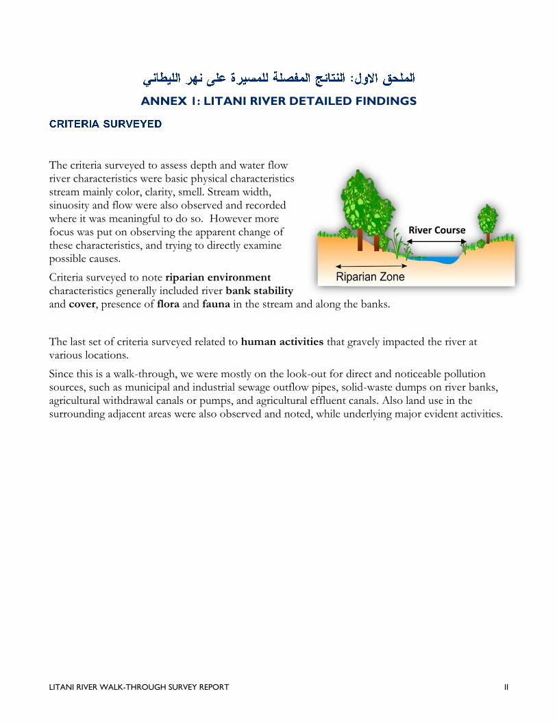
The criteria surveyed to assess depth and water flow river characteristics were basic physical characteristics stream mainly color, clarity, smell. Stream width, sinuosity and flow were also observed and recorded where it was meaningful to do so. However more focus was put on observing the apparent change of these characteristics, and trying to directly examine possible causes.
Criteria surveyed to note riparian environment characteristics generally included river bank stability and cover, presence of flora and fauna in the stream and along the banks.
The last set of criteria surveyed related to human activities that gravely impacted the river at various locations.
Since this is a walk-through, we were mostly on the look-out for direct and noticeable pollution sources, such as municipal and industrial sewage outflow pipes, solid-waste dumps on river banks, agricultural withdrawal canals or pumps, and agricultural effluent canals. Also land use in the surrounding adjacent areas were also observed and noted, while underlying major evident activities.
River Course
LITANI RIVER WALK-THROUGH SURVEY REPORT III
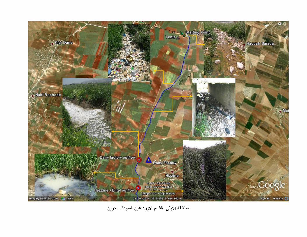
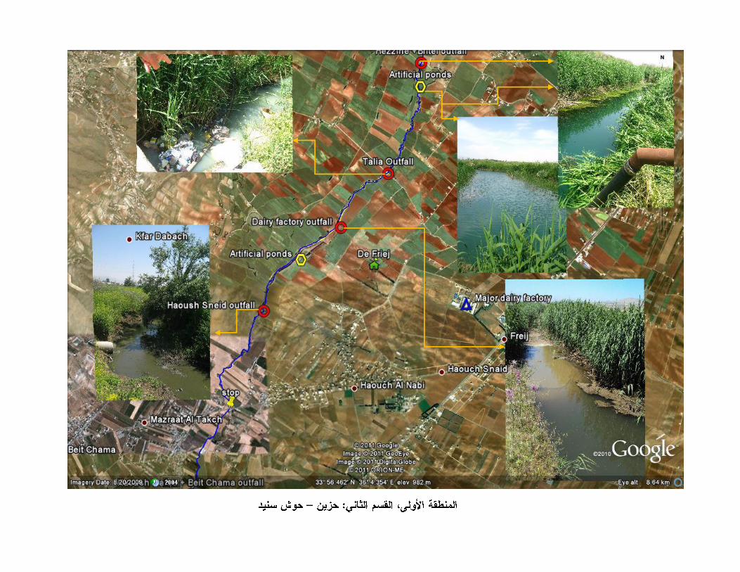
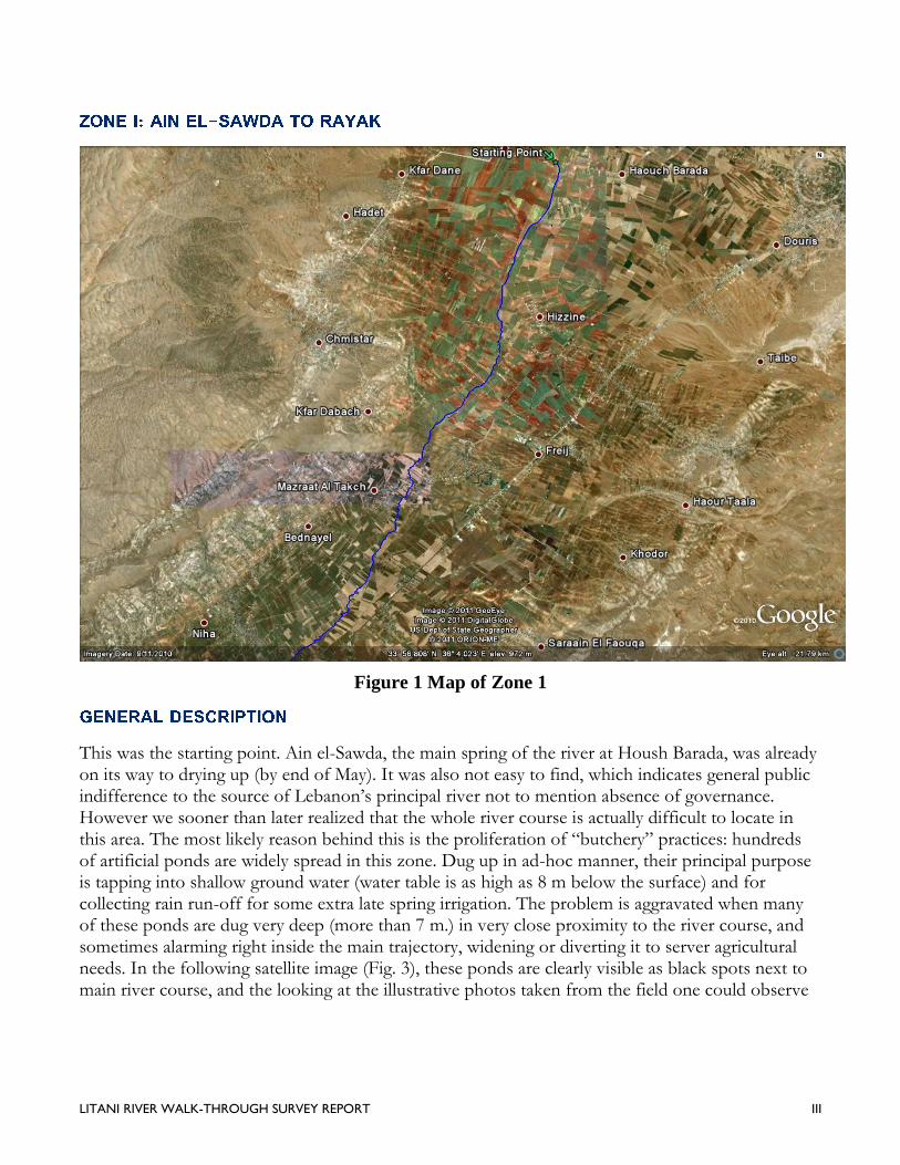
Figure 1 Map of Zone 1
This was the starting point. Ain el-Sawda, the main spring of the river at Housh Barada, was already on its way to drying up (by end of May). It was also not easy to find, which indicates general public indifference to the source of Lebanon’s principal river not to mention absence of governance. However we sooner than later realized that the whole river course is actually difficult to locate in this area. The most likely reason behind this is the proliferation of “butchery” practices: hundreds of artificial ponds are widely spread in this zone. Dug up in ad-hoc manner, their principal purpose is tapping into shallow ground water (water table is as high as 8 m below the surface) and for collecting rain run-off for some extra late spring irrigation. The problem is aggravated when many of these ponds are dug very deep (more than 7 m.) in very close proximity to the river course, and sometimes alarming right inside the main trajectory, widening or diverting it to server agricultural needs. In the following satellite image (Fig. 3), these ponds are clearly visible as black spots next to main river course, and the looking at the illustrative photos taken from the field one could observe
LITANI RIVER WALK-THROUGH SURVEY REPORT IV
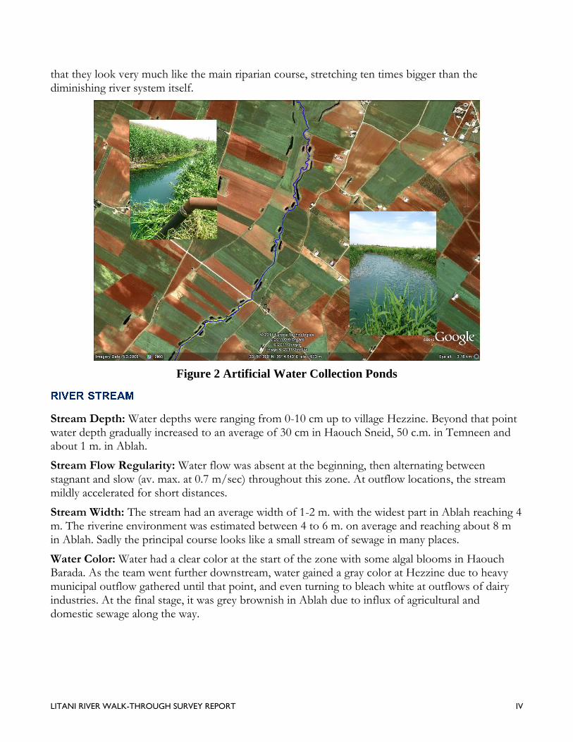
that they look very much like the main riparian course, stretching ten times bigger than the diminishing river system itself.
Figure 2 Artificial Water Collection Ponds
Stream Depth: Water depths were ranging from 0-10 cm up to village Hezzine. Beyond that point water depth gradually increased to an average of 30 cm in Haouch Sneid, 50 c.m. in Temneen and about 1 m. in Ablah.
Stream Flow Regularity: Water flow was absent at the beginning, then alternating between stagnant and slow (av. max. at 0.7 m/sec) throughout this zone. At outflow locations, the stream mildly accelerated for short distances.
Stream Width: The stream had an average width of 1-2 m. with the widest part in Ablah reaching 4 m. The riverine environment was estimated between 4 to 6 m. on average and reaching about 8 m in Ablah. Sadly the principal course looks like a small stream of sewage in many places.
Water Color: Water had a clear color at the start of the zone with some algal blooms in Haouch Barada. As the team went further downstream, water gained a gray color at Hezzine due to heavy municipal outflow gathered until that point, and even turning to bleach white at outflows of dairy industries. At the final stage, it was grey brownish in Ablah due to influx of agricultural and domestic sewage along the way.
LITANI RIVER WALK-THROUGH SURVEY REPORT V
Water Smell: A sharp sewage smell was detected at several locations near municipal flows while farm effluent smells was also present at some hotspots such as dairy sewage outflows and agriculture run off at some locations.
Stream Sinuosity: The stream was starts straight for almost 4 kilometers, then starts to get highly sinuous. However the extensive deformities in its course make such observation pointless.
The river ecosystem in this zone is disturbed with gradually degrading water quality and quantity. This exhibited a clear impact on the fauna and flora as described below.
Flora: Right next to the river, the banks are densely vegetated, with riparian flora comprising mostly of reeds and grasses ranging from 2-4 meters in height. Other riparian flora was limited to small shrubs, thistles and cat-tails, wild herbs. Trees are extremely few, on the rate of 1 every 200 m.
Fauna: Limited to frogs, significant amount of turtles, water snakes and some very small fish. Dragonflies, mosquitoes and flies were also spotted. Riverine birds were also heard at instances.
Bank Stability: Heavy vegetation renders the river banks stable in face of wind or water driven soil erosion. However, it is atypical and hence unsustainable, and the intrusions of human activities beyond the buffer zone at many places render stability, as many of the other physical characteristics scientifically immeasurable.
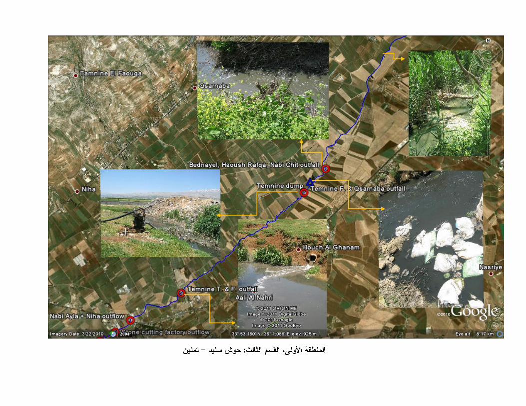
Light to moderate impact from human activity was mostly present throughout this zone, starting with the drying up of Ain el-Saouda due to heavy agricultural withdrawal. These include solid waste, construction waste and sewage effluent disposal. Few yet highly contaminating agro-industrial effluents exist from dairy, poultry and meat industries. One could highlight the presence of extensive amounts of manure in Haouch Sneid and chicken carcasses in Temnine el-Tahta for example.
Water withdrawal and diversion for irrigation was also very common with most farmers using artificial ponds to collect water for the dry season. Some farmers pump sewage water out from the stream to irrigate their lands while others employ extraction from groundwater wells. At least a dozen water pumps were found in this zone, with 4’’ pipes extending to cultivated lands.
In contrast, artificial ponds (mainly from the start of this zone up to Haouch Sneid, showed healthier signs of a river ecosystem such as diverse plant life, different insects, and small fish. In most of these ponds, water quality was observed to be good (clear color, no odors).
Land-use
Agriculture cultivation (mostly tobacco, potato, wheat, grapevines, hashish, vegetables etc.) was predominant all along this zone. Scattered residential units with some livestock (cows, sheep, and goats) were also found mostly downstream of the section. Very few but massive dairy and poultry industrial businesses are present.
LITANI RIVER WALK-THROUGH SURVEY REPORT VI
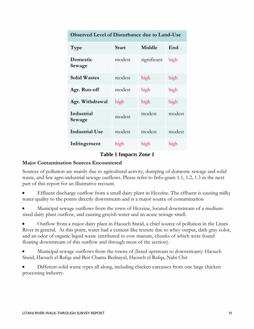
Observed Level of Disturbance due to Land-Use
Type Start Middle End
Domestic Sewage
modest significant high
Solid Wastes modest high high
Agr. Run-off modest high high
Agr. Withdrawal high high high
Industrial Sewage
modest modest modest
Industrial Use modest modest modest
Infringement high high high
Table 1 Impacts Zone 1
Major Contamination Sources Encountered
Sources of pollution are mainly due to agricultural activity, dumping of domestic sewage and solid waste, and few agro-industrial sewage outflows. Please refer to Info-gram 1.1, 1.2, 1.3 in the next part of this report for an illustrative recount.
Effluent discharge outflow from a small dairy plant in Hezzine. The effluent is causing milky water quality to the points directly downstream and is a major source of contamination
Municipal sewage outflows from the town of Hezzine, located downstream of a medium-sized dairy plant outflow, and causing grayish water and an acute sewage smell.
Outflow from a major dairy plant in Haouch Sneid, a chief source of pollution in the Litani River in general. At this point, water had a cement-like texture due to whey output, dark gray color, and an odor of organic liquid waste (attributed to cow manure, chunks of which were found floating downstream of this outflow and through most of the section).
Municipal sewage outflows from the towns of (listed upstream to downstream): Haouch Sneid, Haouch el Rafqa and Beit Chama Bednayel, Haouch el Rafqa, Nabi Chit
Different solid waste types all along, including chicken carcasses from one large chicken processing industry.
LITANI RIVER WALK-THROUGH SURVEY REPORT VII
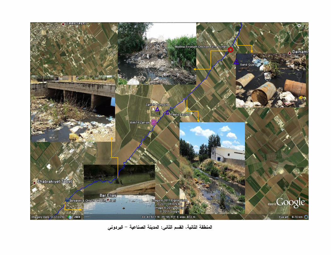
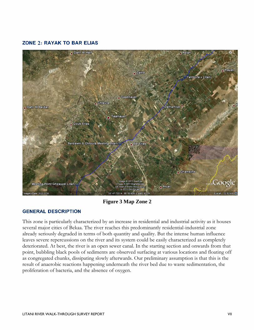
Figure 3 Map Zone 2
This zone is particularly characterized by an increase in residential and industrial activity as it houses several major cities of Bekaa. The river reaches this predominantly residential-industrial zone already seriously degraded in terms of both quantity and quality. But the intense human influence leaves severe repercussions on the river and its system could be easily characterized as completely deteriorated. At best, the river is an open sewer canal. In the starting section and onwards from that point, bubbling black pools of sediments are observed surfacing at various locations and floating off as congregated chunks, dissipating slowly afterwards. Our preliminary assumption is that this is the result of anaerobic reactions happening underneath the river bed due to waste sedimentation, the proliferation of bacteria, and the absence of oxygen.
LITANI RIVER WALK-THROUGH SURVEY REPORT VIII
The river seizes to suffer from intermittence. A side from a very unlikely probability of inflow-increase from underground water resources due to over-pumping of ground water in the area, we assume that this was due to two main reasons: 1- continuous sewage effluents pouring into the main course, 2- the convergence of main tributaries of the Litani; Yahfoufa (upstream) and Chtoura and Berdawni (downstream). But even if the water flow in this zone is considerably enhanced, it is still highly irregular and water quality adopts a worst case scenario. The water is almost completely black, though still running, and producing an insupportably disgusting odor, getting worse by kilometer as one moves downstream, and needless to say it is now blatantly obvious the direct effects such water would have on health and spread of disease. Several locals have complained of numerous hospitalizations and even deaths linked to the ingestion of food irrigated by the waters, not to mention the rising increase in rate of cancer cases. Measuring flow and depth at this point onwards became a practical impossibility and redundancy.
At this point the riverine system is an ecological ruin. It would be nonsensical to even try to assess the river characteristics or health and biota in this zone. High pollution bio-indicators are abundant: the river at beginning of this zone experiences heavy turbidity, and so while it was still possible to identify some micro-invertebrates, and the ones observed consist mostly pollution-tolerant organisms such as worms. Later the water turns almost completely black and highly viscous, making it impossible to even directly observe any representative sample, and one could safely assume an extremely high BOD.
Some turtles and frogs still appear here and there, sometimes in abundance even associating this with high imbalance in ecological habitat, and many times they look ill and weak. Water fowls were absent. This leaves us with the deduction that the ecosystem is barely maintaining few basic and linear predator-host linkages and where the main population is not developing any form of complexity.
As indicated above, the increase of flow is most probably associated with the increase of contaminated water outflows, as underground resources are presumably fully tapped. Effluents from major cities in the basin such as Zahleh, Chtaoura, Quab Elias, El-Marj, Bar Elias gush directly into the Litani. Heavy industrial effluents are the other main culprit in turning the river to a stinking conveyor system for all sorts of heavy wastes.
Land-use
The area is steaming with medium sized industrial localities such as Madina Sinaiah in Zahleh and along the course, and some very large ones such chicken and potato chips, quarries, and dumpsites. This has not stopped farmers and users from pumping and using the river water, although perhaps
LITANI RIVER WALK-THROUGH SURVEY REPORT IX
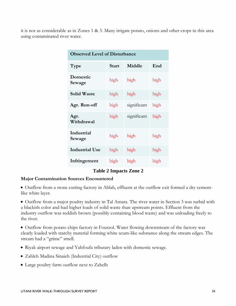
it is not as considerable as in Zones 1 & 3. Many irrigate potato, onions and other crops in this area using contaminated river water.
Observed Level of Disturbance
Type Start Middle End
Domestic Sewage
high high high
Solid Waste high high high
Agr. Run-off high significant high
Agr. Withdrawal
high significant high
Industrial Sewage
high high high
Industrial Use high high high
Infringement high high high
Table 2 Impacts Zone 2
Major Contamination Sources Encountered
Outflow from a stone cutting factory in Ablah, effluent at the outflow exit formed a dry cement-like white layer.
Outflow from a major poultry industry in Tal Amara. The river water in Section 3 was turbid with a blackish color and had higher loads of solid waste than upstream points. Effluent from the industry outflow was reddish brown (possibly containing blood waste) and was unloading freely to the river.
Outflow from potato chips factory in Fourzol. Water flowing downstream of the factory was clearly loaded with starchy material forming white scum-like substance along the stream edges. The stream had a “grime” smell.
Riyak airport sewage and Yahfoufa tributary laden with domestic sewage.
Zahleh Madina Sinaieh (Industrial City) outflow
Large poultry farm outflow next to Zahelh
LITANI RIVER WALK-THROUGH SURVEY REPORT X
Construction dumpsites
Solid waste dumpsites and throw outs at bridges. Open solid waste dump in Temneen (waste burning at river bank), also contributing to the solid waste load in the river.
Agricultural canal run-offs
Zahleh leacheate effluent (unrecorded)
Berdawni pollution load
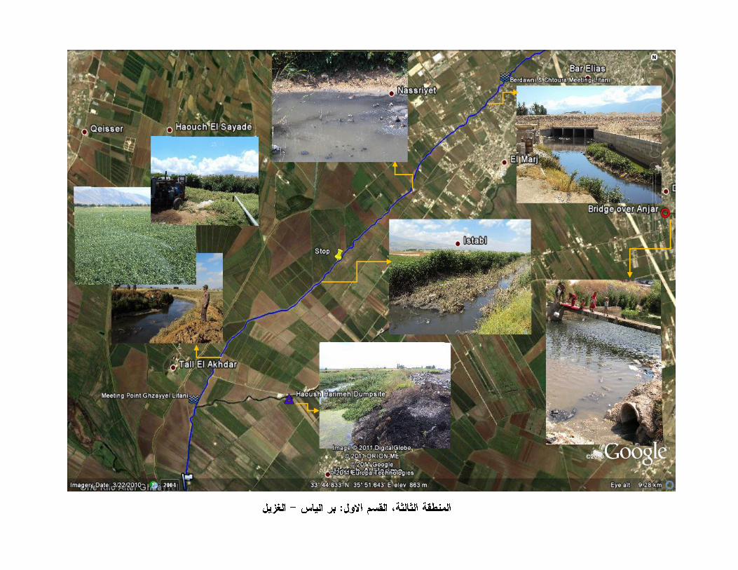
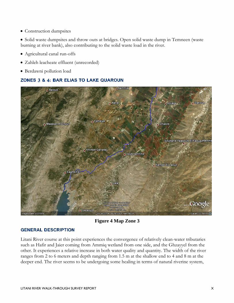
Figure 4 Map Zone 3
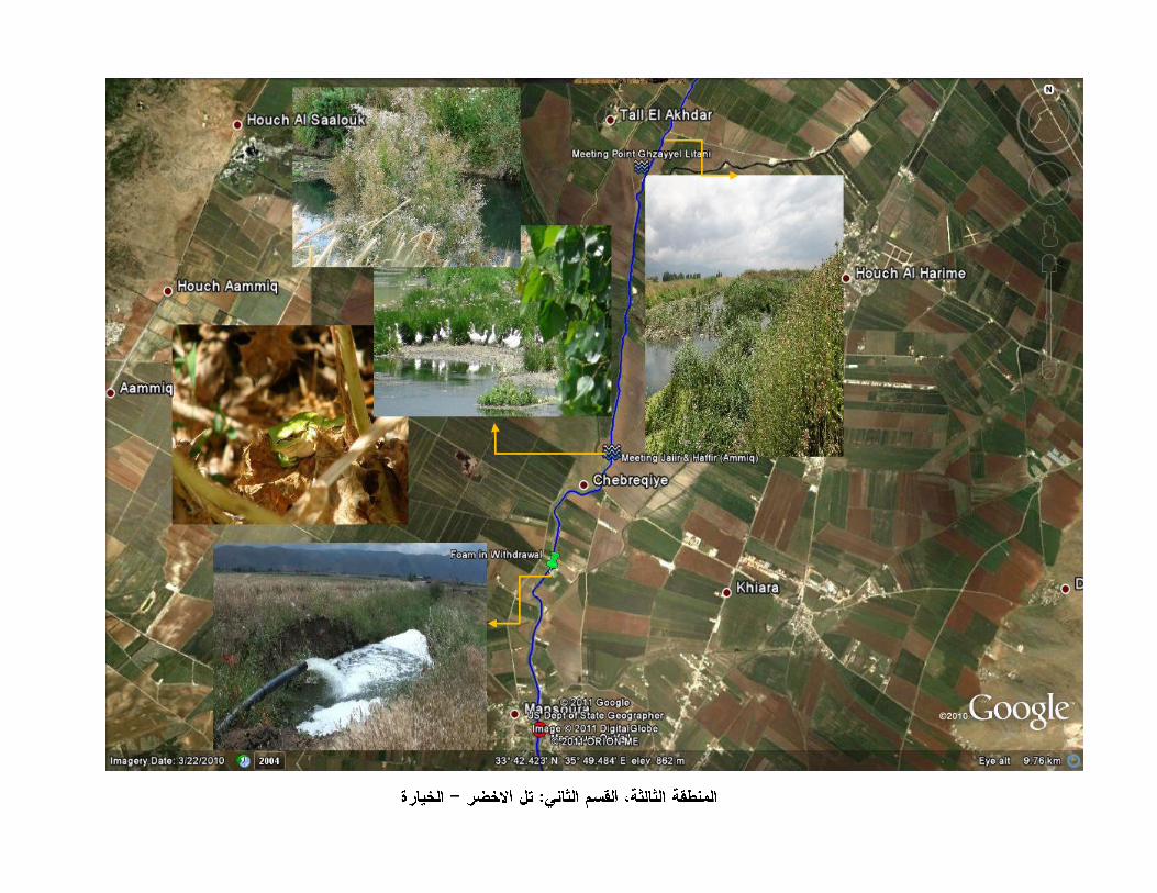
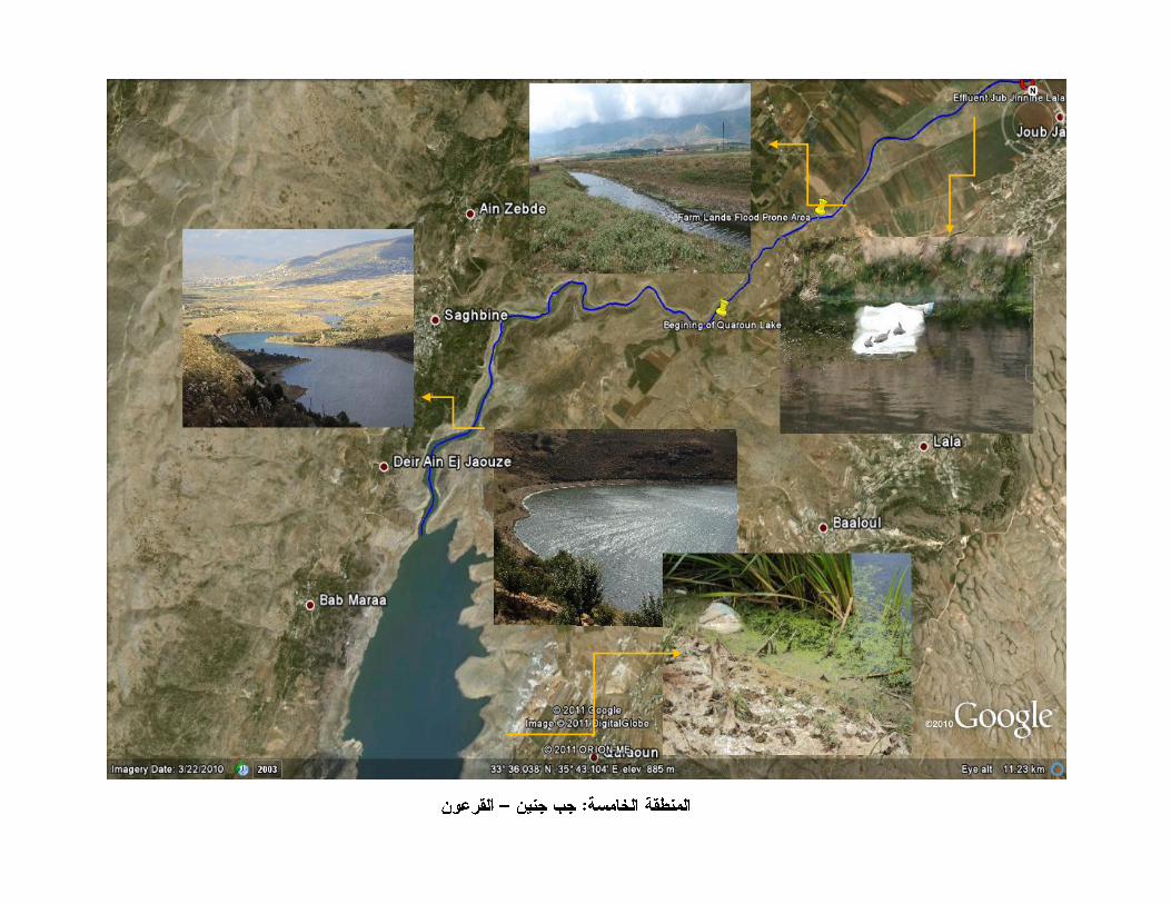
Litani River course at this point experiences the convergence of relatively clean-water tributaries such as Hafir and Jaier coming from Ammiq wetland from one side, and the Ghzayyel from the other. It experiences a relative increase in both water quality and quantity. The width of the river ranges from 2 to 6 meters and depth ranging from 1.5 m at the shallow end to 4 and 8 m at the deeper end. The river seems to be undergoing some healing in terms of natural riverine system,
LITANI RIVER WALK-THROUGH SURVEY REPORT XI
notable by a differentiation in wildlife habitat at locations where there is relatively better waters. This area seemed most prone to natural and recurrent flood occurrences.
Even if the Litani is highly un-river like at the beginning, it slowly gains considerable size and its flow grows to be more regular as it gathers up in water quantity. Some notable improvement in water quality is observed downstream from the location where the Ghzayyel, Hafir and Jaier tributaries intersect with it. turning from brown-black and stagnating, to grayish and flowing despite continuous irregularities caused by proliferation of dense aquatic vegetation. Its width varies considerably (between 4 to 15 meters) depending on artificial linings and previous excavation projects, mostly identified at bridges between major towns. Still flow regularity is obstructed by solid waste and river reeds due to extensive pollution and aberrant build-up of sedimentations due to badly designed river canals.
Some sections are characterized by minimally revived ecological health, where some egrets, wild geese, and water fowls were spotted at the intersection with the Hafir and Jaier rivers which flow in from Ammiq Reserve. One rare Green Frog was spotted. Fish start to considerably populate the wider and deeper sections downstream as one gets closer to the lake and even some new species of aquatic plants were spotted. But a riverine system is continuously disrupted as farm lands infringe on river banks and human construction right next to the course along the river disrupt river bank stability with no respect to buffer zone, causing soil to erode into the river and sedimentation build up.
Human impact is limited to various domestic effluents from several towns, mainly Ghazze, JebJinine, Lala, Baloul, Khirbet Kanafar, Saghbine, but mostly this zone is characterized by heavy agricultural activity. Substantial agricultural run-off enter the river, causing significant algal blooms downstream at Quaroun Lake, or wherever the water flow slows down and is exposed to direct sunlight. On the other hand many water pumps are observed to be installed directly at many points along the river till it reaches the lake.. At one location, the water pumped from the river into a little pond-canal to provide for a small farm was producing a cloud of soap bubbles, indicating high phosphates and nitrates. At bridges and sites where the main river canal was constructed, there seems to be sedimentation build-up and heavy reeds vegetation obstructing water flow as could be seen in Jub Jinine. We also encountered a low land area after Jub Jinine bridge, where a shepherd explained that the water inundated as far as 50 m. inland.
LITANI RIVER WALK-THROUGH SURVEY REPORT XII
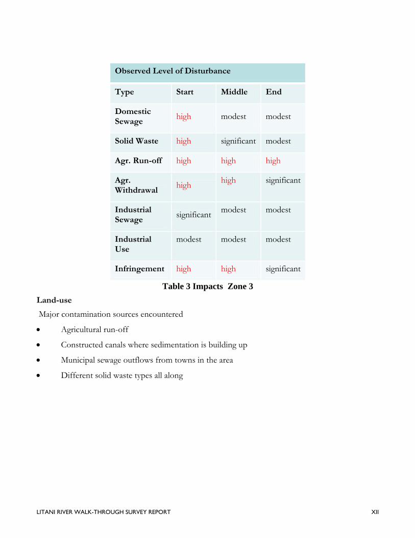
Observed Level of Disturbance
Type Start Middle End
Domestic Sewage
high modest modest
Solid Waste high significant modest
Agr. Run-off high high high
Agr. Withdrawal
high high significant
Industrial Sewage
significant modest modest
Industrial Use
modest modest modest
Infringement high high significant
Table 3 Impacts Zone 3
Land-use
Major contamination sources encountered
Agricultural run-off
Constructed canals where sedimentation is building up
Municipal sewage outflows from towns in the area
Different solid waste types all along

LITANI RIVER WALK-THROUGH SURVEY REPORT XIII
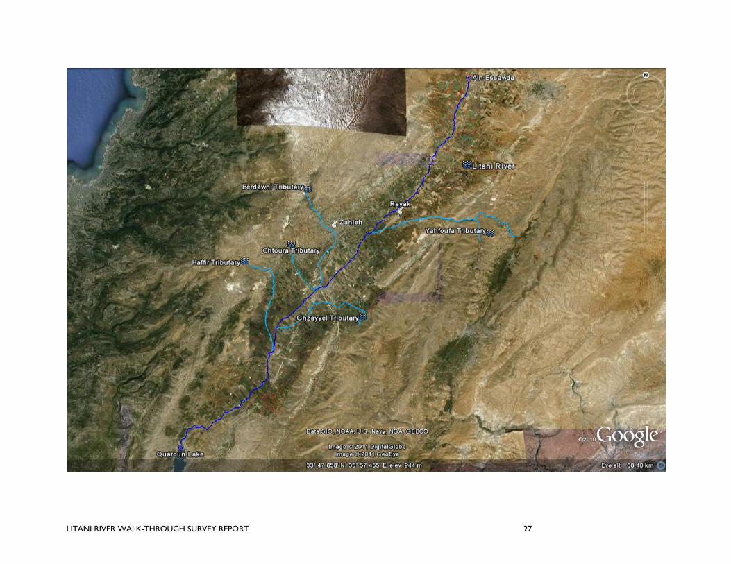
Several tributaries feed into the Litani River, with major contribution to the river’s sustainability and survival, at least during three quarters of the year. The main ones that were considered for this walk-through: Berdawni River, Ghzayyel River, Yahfoufa-Jlala River, Hafir River, Jaeir River, Chtaoura River. Some of these rivers, such as the Berdawni, Jaeir and Yahfoufa, used to be perennial rivers but have demised with time to become canals: conveying storm water during rainy season, and polluted sewage water during dry season. Moreover, they also become transitory garbage disposal systems since they, according to local town folks, “will wash away the garbage to sea”.

LITANI RIVER WALK-THROUGH SURVEY REPORT 27
LITANI RIVER WALK-THROUGH SURVEY REPORT 28
Fortunately, due to their relative short length, slope steepness and strong discharges from mountain springs, some of these rivers maintain a relatively decent situation in terms of quality and quantity, even when dry season prevails and in spite of various infringements. Not as dramatic as the situation of the Litani River, these infringements are limited to the tapping of fresh springs and groundwater for domestic water supply and diversions for irrigation purposes. There are no significant effluents from industrial activity (except some on Berdawni), and being torrential in nature, they tend to have a quick recuperation rate. This being said, the method used here contrasts with the one used for Litani main course which was more rigorous. A “skimming through” technique was used for tributaries more dependent on motorized transportation, and reporting visual observations and facts at several important locations when happened when considered necessary.
1
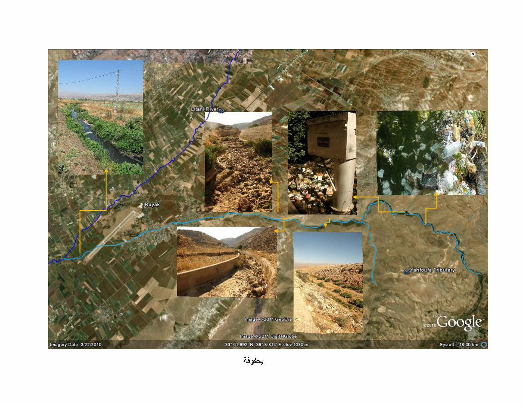
Previous data and reports show that water flow of this river has been both perennial and substantial in the past. The watershed stretches from anti-Lebanon mountain range, and meets with Litani basin at Rayak. Apart from some greenery along the banks the land is generally barren due to little snow accumulation and low water table common to Jurassic geologic formations. Two river springs water small towns upstream such as Yahfoufa and a partially a larger town called Nabi Chit. The springs converge at Janta and pass through Massa, Nasriyeh, Hai el-Fikani and Rayak.
The river starts well at source next to the Lebanese-Syrian border. There the springs is harnessed for domestic and small-scale agricultural use. Some resorts and restaurants were observed upstream. Due to heavy withdrawals, presumably for agricultural activity and domestic use, the water level considerably declines half way downstream. There is a 5 meter-wide (approx.) lined canal at the mid section; it is however completely dry. The green procession of trees disappears at this point> Given that the slope is not as steep as other Litani tributaries leaves us with the studied guess that water flow has undergone dramatic set back. The river remains dry till it joins the Litani main course.
At its onset, water seems of good quality aside from heavy solid waste dumping at spring sites or in river. The uppermost section visited here has an LRA gauging station, crystal clear water, and loaded with plastics and non-degradable solid wastes. At midstream, the large quantities of dry algal mesh observed inside the canal having a sun-crusted surface yet still slightly green and pliant at core suggests pollution from agricultural activity and quick water level decline. Downstream until Rayak,
1 Little reliable information could be gathered from the field due to security and logistical reasons as the river passes in high security zone.
LITANI RIVER WALK-THROUGH SURVEY REPORT 29
the river was completely dry. However, after entering and existing Rayyak town and military airport, black and foul-smelling effluent water starts to flow through again, and this is how this tributary joins the Litani: a highly polluted mixture of domestic, industrial and agricultural liquid waste flow.
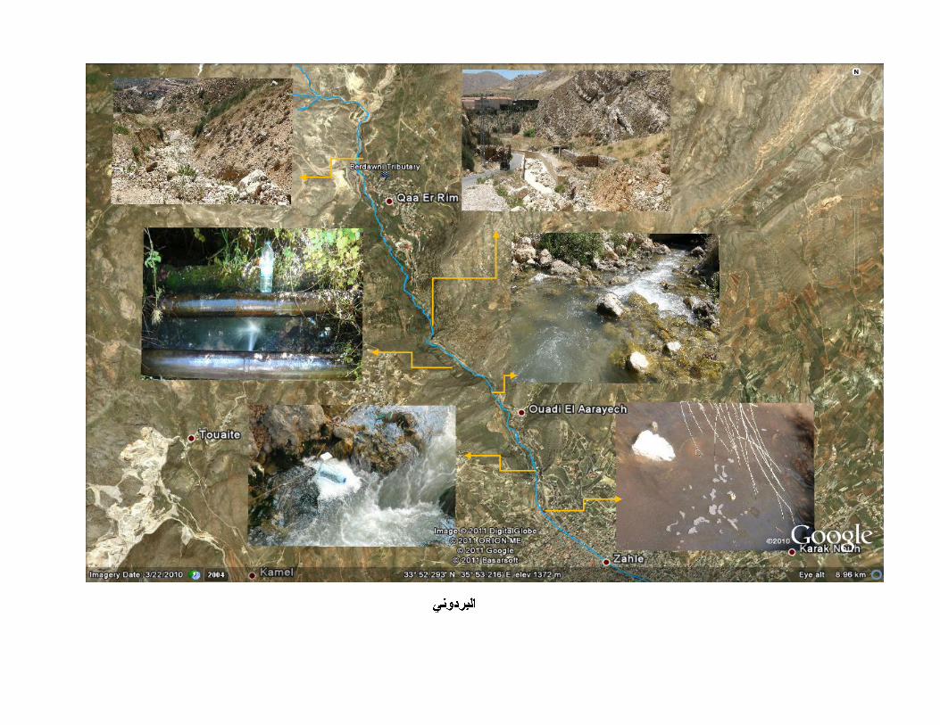
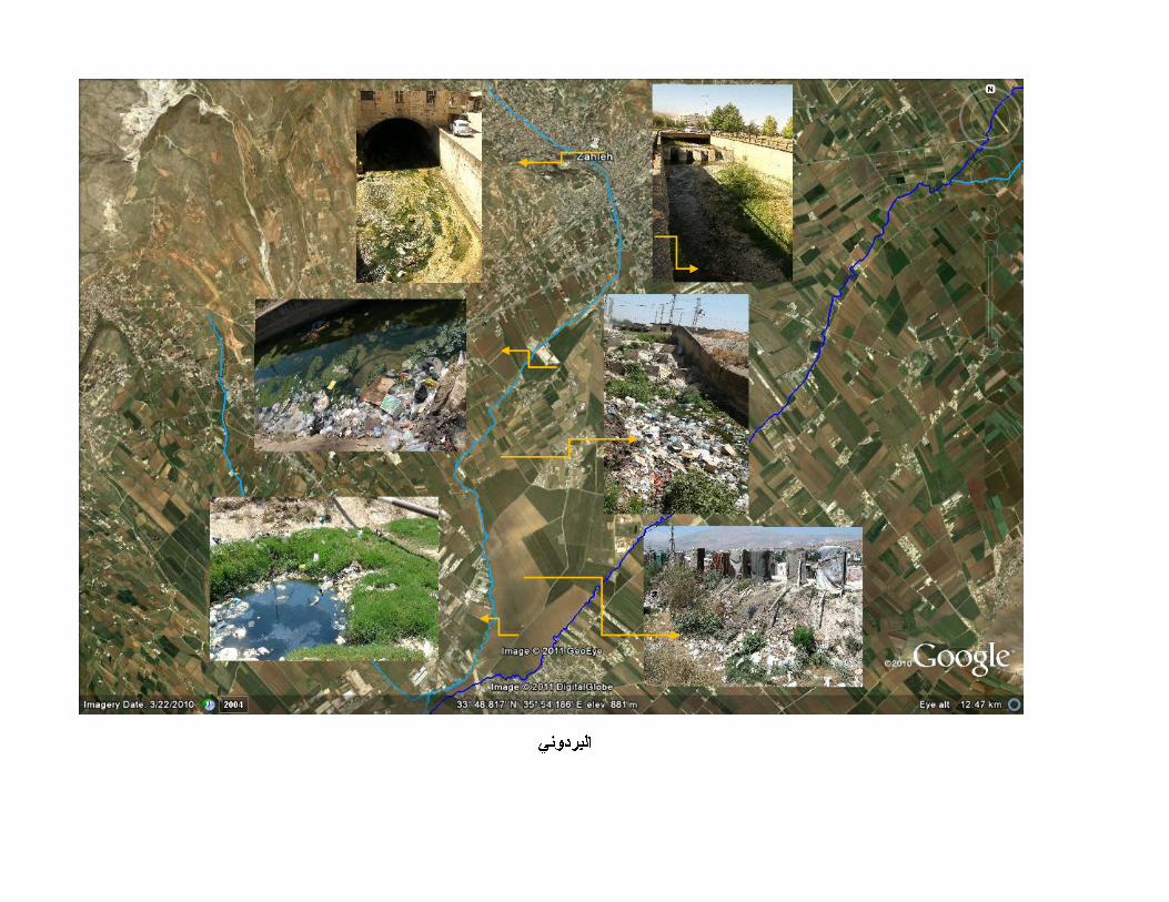
The Berdawni River is a western tributary of the Litani River which starts under Mountain Sannine, flows through Zahleh and joins the Litani downstream of the Damascus highway. Similar to other tributaries, the Berdawni presents a steep and narrow upstream riverbed which becomes wider and slower once it reaches the valley floor.
The Berdawni was historically known for its continuous and strong flow due to several significant springs. Zahleh, the biggest city in the ULB, was founded along the river and still centers around it, with many commercial activities such as restaurants and artisanal shops. Zahleh and its Berdawni River were indeed celebrated in the past in a song by famed singer Abd el-Wahab.
As a typical mountain torrent, the Berdawni is first known for sudden floods that can overflow the banks and impact properties and possibly human lives. The last twenty years have seen a drastic decline of the Berdawni flows: the river does not flow anymore in summer, except for sewage effluents.
Its springs and waters are used for municipal needs, industrial activities (such as water bottling) and some irrigation. Several industries located in the upstream villages of Qua el Rim and Hazzerta have legal withdrawal rights and capture a significant portion of the springs, while the rest is diverted towards Zahle water supply network. The summer flow is thus mainly formed by domestic and industrial sewage effluents, while garbage dumping also adds to the pollution and smell. Downstream of Zahleh, the residual flows are also captured by farmers for irrigation.
In the 90s, a spring enhancement project was implemented with the goal of tapping the springs to increase their flows. This project did not succeed and may even have decreased the spring flows. This has further contributed to an allocation and political conflict between Zahleh and the upstream villages of Qua el Rim and Hazzerta.
In summer, the Berdawni meager flow is composed of mix-type sewage. The first being domestic sources from upstream villages of Hazzerta, and Qua el Rim, Zahleh and its suburbs, and notably the restaurants along the river banks. A gypsy camp below Zahleh also contributes to the pollution through many outdoor latrines on both river banks. The major industrial pollution load comes from a paper/tissue factory and water bottling firms in Hazzerta and Qua el Rim, as well as garages in the
LITANI RIVER WALK-THROUGH SURVEY REPORT 30
outskirts of Zahleh. Agricultural sources include run-off from farmed lands downstream of Zahleh some algal bloom becomes visible in a drying river bed. Before joining the Litani, this type of pollution becomes more prominent since the river is now passing through large agricultural plots where one could spot a large chicken farm/factory. The Berdawni infested with algae and very smelly joins a by now ruined Litani.
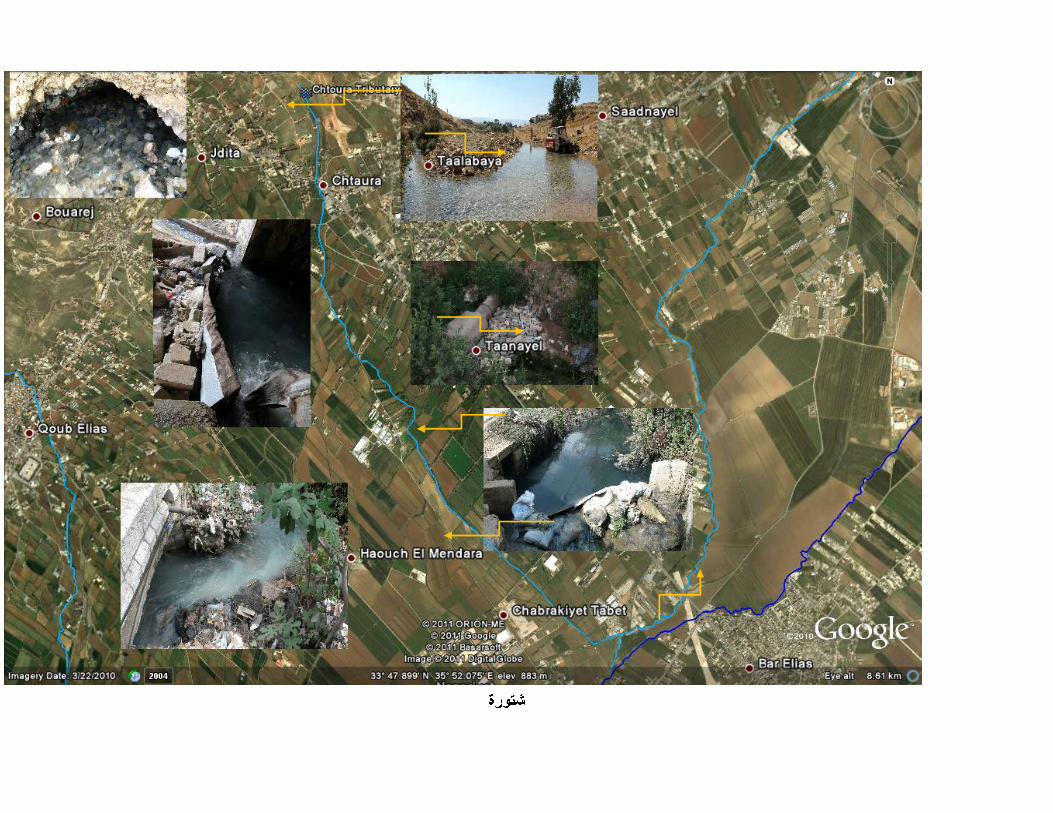
These two tributaries neighbor each other and have been both highly altered into a network of canals used to supply and distribute irrigation water mainly for the large towns of Jdita, Chtoura, Taanyel, Qob Elias and Chebarqiyeh. The river of Jaeir used to be a spring-fed perennial tributary; however it now only serves as a storm-water canal. The Chtoura River on the other hand still flows perennially, and so more attention was invested to follow this short yet substantial tributary. However, recently the governor’s selected water guards, paid per ‘release’, increased their profit by diverting sewage effluents of nearby towns to increase flow quantities. They use small customized weirs to gather the water and release it to towns downstream of Jdita for considerable extra sums of money.
The uppermost springs of the Chtoura River discharge abundantly even during dry season. This tributary is able to feeds the surrounding agricultural lands through an old distribution system. At Taanayel the river splits two ways through custom made diversion weirs: part goes towards Qob Elias and Nasriyeh agricultural lands where it later empties directly into the Litani. The other part goes into Taanayel farming lands, where shortly thereafter joins with the Berdawni as they both empty into Litani. The river irrigates the towns of Jdita, Taalbaya & Chtoura upstream, and Taanayel, Zubdol, Chebarqiyeh, and Qob Elias. Jaeir, when active, feeds more or less into this same system. At the end of the dry season, and after being almost exclusively exploited for irrigation purposes, the river remains but a small stream of polluted water.
Chtoura Spring lets out very clean water which runs for a couple of kilometers, passes some restaurants, and mixes with sewage effluents of the surrounding towns, turning black and malodorous just after it exists Chtoura on the Demascus Highway. The notable industrial activity which pollutes Chtoura River is chiefly dairy and wine processing, which Jdita and neighboring towns are famous for. These activities and the purposeful incorporation of sewage effluents with fresh river water, in addition to old existing sewage networks which already empty into this tributary, considerably increased BOD levels. Some effluent and heavy detergents from car garages accentuate the gravity of the situation. No cow farms though until the river passes through Taanayel where
LITANI RIVER WALK-THROUGH SURVEY REPORT 31
some organic waste from small farms adds to the pollution load. At those towns it joins another small polluted river called Jlala. Before it meets the Berdawni, a ceramic industry outflow pours into it, and they both join the Litani a contaminated stream.
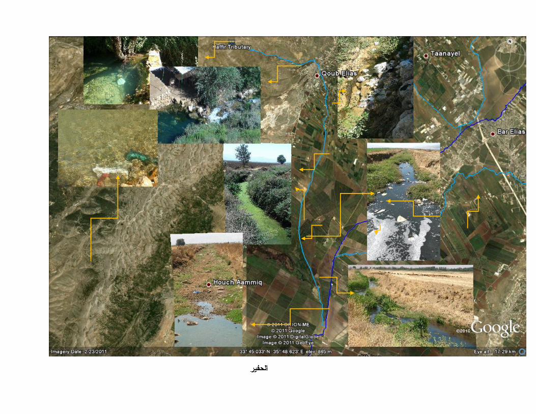
This tributary maintains a perennial status, though it is almost dry just before it joins the Litani downstream. It is used for little tourism and leisure, but almost exclusively for agriculture.
The Hafir enjoys the provision of one main spring at the start called “Ain el Zarka” with several smaller springs feeding into it. It is the main resource which feeds the vast agricultural areas of Qob Elias and surrounding villages through a conventional yet operational water distribution system with water guards. Other irrigation water is diverted from Chtoura River and some from Jaier River, but the latter is not perennial. With shortage, there is heavy reliance by farmers on private wells and pumping from the Litani main course. The flow in this tributary has decreased over the years because of declining rainfall, over pumping of groundwater, and mounting consumption.
The Hafir maintains an acceptable condition in terms of quality too until it passes through Qob Elias rural lands downstream. There is little industrial or intensive agricultural activity prior to that point, and domestic sewage waters from towns around generally go into septic tanks. A sudden change in its quality is observed as heavy agricultural and industrial (plastic factory/bottling..) discharges enter, next to domestic liquid effluents of houses with no septic tanks and domestic garbage. It soon turns into an ecological hazard till it reaches the Litani. Heavy pumping from underground wells as well as direct irrigation from the river lower water levels drastically, amplifying the pollution of its waters. Since this walk-through happened during the dry season when the water level is at its lowest, one could see garbage hanging from trees on river banks of a river drying up quickly, reflecting the gravity of the situation.
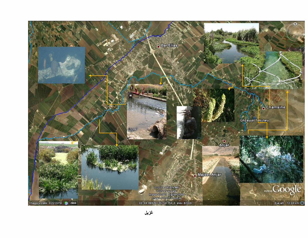
Ghzayyel River enjoys a privileged position: its upstream freshwater springs flow abundantly through protected areas and a natural reserve. It is fed from two main springs flowing continuously throughout the year: The Anjar Spring, the Chamsine Spring, which are located in towns of the same name (Chamsine is alternatingly called Kfar Zabad). Both municipalities of Anjar and Kafar Zabad along with local initiatives and civil society have taken measures in preserving the springs’
LITANI RIVER WALK-THROUGH SURVEY REPORT 32
area and adapted some customary practices to this end. Such measures include: spring area maintenance, tree-planting, and halting uncontrolled garbage dumping, and some eco-tourism activities.
Ghzayyel still retains good discharge levels, estimated around 2m/s in dry season. Its springs provide abundant clean water for irrigating the lands in and around Anjar and Kfarzabad, reaching Bar Elias. They also provide drinking water for the town through a municipal network, or withdrawn and sold by private distributers. Important to note that Anjar municipality has a 60-year old water committee since the times of the French mandate, self-organized for managing a fair irrigation scheme for Anjar famers, being one of a kind in Lebanon. The Ain el-Bayda Spring, a conglomeration of three smaller springs, used to be perennial in the past, but presently dried-up due to over-pumping north of the river
The Ghzayyel enjoys little tampering while generously flowing until it passes the Damascus highway at Dier Zanoun bridge. From that point onwards, unrestrained intensive water withdrawal occurs for irrigation purposes. Even so, one could still safely surmise that it is the perhaps the Litani River’s best tributary in terms of this function.
Prior to Dier Zanoun Bridge, pollution levels are minimal and manageable, with remarkable pristine riverine ecology absent with other tributaries. The water remains of high quality for several kilometers downstream of source, even with the presence of few polluting activities such as fish, chicken and cow farming. Also, some sewage effluents from restaurants discharge into the river during spring/summer season. Garbage dumping in the river remains a problem, but poses little effect on the deterioration of water quality and old garbage present in the river bed pose little risk. Some oil or fuel leakages coming from large water pumps positioned directly on river bank has been noted in Bar Elias area.
However, beyond Dier Zanoun bridge, heavy sewage discharges enter the river mainly from: Anjar, Majdal Anjar, Bar Elias and other villages. This causes a dramatic shift in water quality, the river turning highly polluted and its ecology degraded. Several effluents from other villages downstream introduce more agriculture discharge, and algae proliferation becomes notable. Few small dumpsites such as that of Housh el Harimeh village were found on the banks until the river joins the Litani.


LITANI RIVER WALK-THROUGH SURVEY REPORT 34
U.S. Agency for International Development
1300 Pennsylvania Avenue, NW
Washington, DC 20523
Tel: (202) 712-0000
Fax: (202) 216-3524
www.usaid.gov
U.S. Agency for International Development
1300 Pennsylvania Avenue, NW
Washington, DC 20523
Tel: (202) 712-0000
Fax: (202) 216-3524
www.usaid.gov