tunbridgewells.gov.uk...reg. office: sweco uk limited grove house mansion gate drive leeds, ls7 4dn...
TRANSCRIPT

Reg. office:
Sweco UK Limited
Grove House
Mansion Gate Drive
Leeds, LS7 4DN
+44 20 3002 1210
www.sweco.co.uk
Reg.no 2888385
Sweco
Lector Court
151-153 Farringdon Road
London EC1R 3AF
TWBC LOCAL PLAN TRANSPORT EVIDENCE BASE
Transport Assessment Report PROJECT REF: 121284
Sweco
Lector Court
151-153 Farringdon Road
London, EC1R 3AF
,
FINAL DRAFT Prepared for: Tunbridge Wells Borough Council (TWBC)
Sep 2019

Status / Revisions
VER. DATE CHANGE CONCERNS REVIEWED APPROVED
01 JUNE 19 Final – 1st Draft Lorna Parsons
Mark Fitch
02 JULY 19 FINAL DRAFT Dermot Hanney
Mark Fitch
03 SEP 19 FINAL – COMMENTS FROM CLIENT
Dermot Hanney
Mark Fitch
© Sweco 2017. This document is a Sweco confidential document; it may not be reproduced, stored in a retrieval system or transmitted in any form or by any means, electronic,
photocopying, recording or otherwise disclosed in whole or in part to any third party without our express prior written consent. It should be used by you and the permitted
discloses for the purpose for which it has been submitted and for no other.

Reg. office:
Sweco UK Limited
Grove House
Mansion Gate Drive
Leeds, LS7 4DN
+44 20 3002 1210
www.sweco.co.uk
Reg.no 2888385
Sweco
Lector Court
151-153 Farringdon Road
London EC1R 3AF
Table of Contents
1. Introduction .................................................................................................................. 1
1.1. Background.............................................................................................................. 1
1.2. Report Purpose ....................................................................................................... 1
1.3. Objectives ................................................................................................................ 2
1.4. Outline Methodology ................................................................................................ 2
1.5. Scope of Planning Information Included .................................................................. 3
1.6. Report Structure ...................................................................................................... 4
2. Policy Context .............................................................................................................. 5
2.1. Introduction .............................................................................................................. 5
2.2. National Policy ......................................................................................................... 5
2.3. Regional Policy ........................................................................................................ 7
2.4. Local Policy............................................................................................................ 11
2.5. Neighbouring Plans and Transport Strategies ...................................................... 17
2.6. TWBC Air Quality Action Plan 2018 to 2023 ......................................................... 18
3. Socio-Demographics and Travel Behaviour .............................................................. 21
3.1. Introduction ............................................................................................................ 21
3.2. Borough-Wide Context .......................................................................................... 21
3.3. Socio-Economic Analysis ...................................................................................... 23
3.4. Current Travel Behaviour ...................................................................................... 31
4. Existing Walking and Cycling Infrastructure .............................................................. 43
4.1. Introduction ............................................................................................................ 43
4.2. Cycling Infrastructure ............................................................................................. 43
4.3. Walking .................................................................................................................. 45
5. Existing Public Transport Infrastructure and Level of Service ................................... 48
5.1. Introduction ............................................................................................................ 48
5.2. Tunbridge Wells Borough – East ........................................................................... 49
5.3. Tunbridge Wells Borough – Central Region .......................................................... 60
5.4. Tunbridge Wells Borough – North ......................................................................... 74
5.5. Tunbridge Wells borough – West (Royal Tunbridge Wells Urban Area) ............... 85
6. Highway Network, Congestion and Collision Analysis ............................................ 100
6.1. Introduction .......................................................................................................... 100
6.2. Highway Network ................................................................................................. 100
6.3. Congestion........................................................................................................... 101

Reg. office:
Sweco UK Limited
Grove House
Mansion Gate Drive
Leeds, LS7 4DN
+44 20 3002 1210
www.sweco.co.uk
Reg.no 2888385
Sweco
Lector Court
151-153 Farringdon Road
London EC1R 3AF
6.4. Air Quality ............................................................................................................ 106
6.5. Parking ................................................................................................................. 108
6.6. Park and Ride ...................................................................................................... 118
7. Growth and Development in the Borough ............................................................... 119
7.1. Introduction .......................................................................................................... 119
7.2. Local Plan Development Site Allocations ............................................................ 119
8. Trip Generation and Model development ................................................................ 124
8.1. Traffic Impact Baseline Analysis.......................................................................... 124
9. Mitigation Measures ................................................................................................ 134
9.1. Mode Shift Spread ............................................................................................... 134
9.2. Case Studies – Supporting Evidence .................................................................. 134
9.3. Case Studies - Bus .............................................................................................. 134
9.4. Case Studies - Cycling ........................................................................................ 135
9.5. Case Studies - Multi-modal Area Wide Measures ............................................... 136
9.6. Adopted Mitigations ............................................................................................. 136
9.7. Mitigations Discounted in Final Analysis ............................................................. 143
9.8. Mitigation Outcomes and Recommendations ...................................................... 147
9.9. Additional Sensitivity Testing – North Farm Road / Dowding Way Rail Under-
bridge Link ....................................................................................................................... 154
9.10. Timescales ........................................................................................................... 154
10. Summary and Conclusions ...................................................................................... 157
10.1. Summary of Key Findings ................................................................................... 157
10.2. Conclusions ......................................................................................................... 161

Reg. office:
Sweco UK Limited
Grove House
Mansion Gate Drive
Leeds, LS7 4DN
+44 20 3002 1210
www.sweco.co.uk
Reg.no 2888385
Sweco
Lector Court
151-153 Farringdon Road
London EC1R 3AF
1
1. Introduction
1.1. Background
1.1.1. Tunbridge Wells Borough Council (TWBC) is currently preparing its new Local Plan, which
will cover the period 2013 – 2036. The new Local Plan will provide the overarching
principles that will guide future development within the borough during the Local Plan
period up to 2036. The new Local Plan will replace the existing Local Plan 2006, Core
Strategy 2010 and Site Allocations Local Plan 2016. TWBC are aiming to adopt the new
Local Plan in summer 2020.
1.1.2. The new Plan will set the vision and framework for development within the borough to
2036 including for housing, the economy, community facilities and infrastructure. The
policies within the Plan will promote sustainable development to address design, climate
change and environmental protection, whilst meeting the needs of current and future
generations.
1.1.3. In preparing the new Local Plan, TWBC needs to consider, and consult on, sustainable
options for meeting housing and other development needs. As part of this process, TWBC
has commissioned Sweco to provide a Transport Assessment to gather evidence on, and
evaluate, the potential transport impacts of the emerging draft Local Plan and investigate
mitigation measures to alleviate such impacts.
1.2. Report Purpose
1.2.1. Mobility and transport are an integral part of society and a key issue in a largely rural area
like Tunbridge Wells borough. Increasing car ownership and usage in line with national
trends result in a high dependency on the private car to satisfy movement needs. The
resulting increase in traffic volumes and road congestion contribute to and create a poorer
quality environment. The car is a convenient and versatile means of transport for many but
at increasing social, environmental and economic cost.
1.2.2. As such, it is recognised that the delivery of the borough/s development growth needs is
intrinsically linked to infrastructure and transport delivery. It is fundamental that places and
communities are well connected with each other, the surrounding areas and beyond, for
the purposes of employment opportunities and access to day-to-day services and facilities
for future generations.
1.2.3. With this in mind, the purpose of this Transport Assessment is two-fold:
• To understand the transport implications of the Preferred Growth Strategy in the Council’s
emerging Local Plan across the borough of Tunbridge Wells, taking account of growth
scenarios in neighbouring districts; and
• To assist in the preparation of a borough-wide Transport Strategy to support the
emerging Local Plan, reflecting current best practice and Government guidance.

Reg. office:
Sweco UK Limited
Grove House
Mansion Gate Drive
Leeds, LS7 4DN
+44 20 3002 1210
www.sweco.co.uk
Reg.no 2888385
Sweco
Lector Court
151-153 Farringdon Road
London EC1R 3AF
2
1.3. Objectives
1.3.1. The main objectives of the Transport Assessment (TA), as set out in TWBC’s “Transport
Evidence Base – Specification” document, are to:
• Assess the quality and capacity of transport infrastructure across the borough and its
ability to meet forecast demands.
• Assess the cumulative impacts of the Preferred Growth Strategy on all transport modes
and networks and the impact on the locality, including the impact on networks in the
locality of sensitive designated international sites.
• Set out proposals to minimise the impact of the development on the transport network to
inform the infrastructure requirements associated with the Local Plan.
• Promote measures to encourage sustainable transport.
1.4. Outline Methodology
1.4.1. Sweco attended an Inception Meeting with TWBC and Kent County Council (KCC) officers
on 9th Jan 2019 where the study constraints and thus, the scope of works for the TA were
established. This included the methodology to be adopted for the assessment of the
cumulative impacts on the highway network. The key stages and methodology
discussed/agreed are summarised below:
• Stage 1: Baseline Study – Establish and analyse the existing transport conditions
considering policy, stakeholder aspirations and development principles. This study would
be based on the existing datasets and information as provided by TWBC/KCC. The key
topics discussed in this Stage cover the following areas:
• A policy review of key national, regional and local planning and transport policy.
• Study of existing transport infrastructure (all modes) including, where possible,
usage and capacity.
• Collision analysis along key corridors and junctions within the borough.
• High level travel behaviour and demographic analysis of residents and employees
at both borough and local level.
• Assessment of the existing traffic conditions on the highway network based on a
spreadsheet analysis of the available baseline link and junction traffic flow data.
• Summary of anticipated development during the Local Plan period.
• Stage 2: Transport Capacity Assessment – An assessment of the impact of the
preferred growth strategy on the transport networks and infrastructure (all modes) based
on an analysis of:
• Anticipated level of development, especially housing.
• The locational strategy for distribution of new development around the borough.
• Estimate of multi-modal trip rates arising from new residential and commercial
development using TRICS trip rate data.

Reg. office:
Sweco UK Limited
Grove House
Mansion Gate Drive
Leeds, LS7 4DN
+44 20 3002 1210
www.sweco.co.uk
Reg.no 2888385
Sweco
Lector Court
151-153 Farringdon Road
London EC1R 3AF
3
• Modal share, trip distribution and assignment assessment taking account of
localised travel characteristics and patterns established from Census 2011 data.
• Identification of areas of traffic growth, arising from development within the Local
Plan.
• TEMPRO future year trip rates to account for neighbouring district growth.
• Utilising junction turning count and ANPR data provided by TWBC/KCC, a
comprehensive highway model will be built using Saturn simulation to assess the
traffic impacts on the core study area of Royal Tunbridge Wells, Tonbridge and
Paddock Wood town centres, plus the connecting network between these towns.
• The impacts of the growth strategy, in particular modal shifts, on the transport
networks/infrastructures, will be assessed utilising a Cube Voyager model.
• Stage 3: Mitigation Measures – A comprehensive list of transport interventions will be
identified and developed based on the assessments undertaken, liaison with key
stakeholders and the application of specialist knowledge and analysis.
• Building on an aim to reduce the need to travel in the first place, the transport
interventions will focus on the promotion of sustainable and active modes.
• All options are to be considered, including large scale highway improvement
schemes and smaller scale initiatives to improve public transport facilities and
increase pedestrian and cycle permeability, through the provision of new and
improved walking and cycling links.
• The transport interventions will be assessed using a combination of qualitative
(appraisal framework spreadsheet) and quantitative (transport modelling)
methods.
• Stage 4: Final Transport Assessment and Next Steps – This TA report and
accompanying Modelling Technical Note represent the outcomes of Stage 4. It sets out
the outcomes of the study including mitigation measures required to support the preferred
development growth.
1.5. Scope of Planning Information Included
1.5.1. Please note that this report is based on provisional information provided by Tunbridge
Wells Borough Council for the purposes of testing the cumulative transport impacts of
potential development sites on the existing network. Following further investigations by the
Borough Council, the capacity, or inclusion, of sites has varied in some instances, but the
overall housing numbers assessed in the report (10,205 dwellings) compares very closely
to the allocations in the Draft Local Plan (10,133 dwellings). It is noted that sites with
planning permission and previous allocations are dealt with separately. Similar provisos
apply to employment-generating sites, where assumptions are made regarding capacity
when these were not available.

Reg. office:
Sweco UK Limited
Grove House
Mansion Gate Drive
Leeds, LS7 4DN
+44 20 3002 1210
www.sweco.co.uk
Reg.no 2888385
Sweco
Lector Court
151-153 Farringdon Road
London EC1R 3AF
4
1.5.2. This assessment will be updated following the Borough Council’s consideration of
comments on the Draft Local Plan.
1.6. Report Structure
1.6.1. Following this introduction, the remainder of this TA is structured as follows:
• Chapter 2: Policy Context – summarises the key policy considerations that the TA has
had regard to;
• Chapter 3: Socio-Demographics and Travel Behaviour – provides a high-level review
of the borough-wide socio-demographics which influence travel behaviour
• Chapter 4: Existing Walking and Cycling Infrastructure – provides a high-level review
of the current active travel modes across Tunbridge Wells Borough;
• Chapter 5: Existing Public Transport Infrastructure – provides a high-level review of
the current public transport networks across Tunbridge Wells Borough;
• Chapter 6: Highway Network, Congestion and Collision Analysis - provides a high-
level review of the current highway network across Tunbridge Wells Borough;
• Chapter 7: Growth and Development in the Borough – summarises the proposed new
Local Plan development strategy;
• Chapter 8: Trip Generation and Model Development – sets out the methodology for
establishing the future year trips associated with the emerging development strategy and
the results of the developed Future Baseline;
• Chapter 9: Mitigation Measures – summarises a range of potential measures to
mitigate the impacts of the Local Plan growth, including highway infrastructure
improvements and public transport and active travel infrastructure improvements to
facilitate modal shift from the private car; and summarises the results of the multi-modal
transport modelling of the Future Baseline + development scenario in comparison with
2018 Baseline and Future Baseline;
• Chapter 10: Summary and Conclusions – summarises the work undertaken, the
outcomes of the study and the recommended next steps.

Reg. office:
Sweco UK Limited
Grove House
Mansion Gate Drive
Leeds, LS7 4DN
+44 20 3002 1210
www.sweco.co.uk
Reg.no 2888385
Sweco
Lector Court
151-153 Farringdon Road
London EC1R 3AF
5
2. Policy Context
2.1. Introduction
2.1.1. Local Plans set out the strategic priorities for development of an area and cover housing,
commercial, public and private development, including transport infrastructure, along with
protection for the local environment.
2.2. National Policy
National Planning Policy Framework
2.2.1. The latest National Planning Policy Framework (NPPF), published in February 2019 sets
out the Government’s planning policies for England and how these should be applied. It
provides a framework within which locally-prepared plans for housing and other
development can be produced. The NPPF must be taken into account when preparing
development plans and is a material consideration in planning decisions.
2.2.2. The NPPF states that ‘planning policies and decisions should play an active role in guiding
development towards sustainable solutions, but in doing so should take local
circumstances into account, to reflect the character, needs and opportunities of each
area.’1 As a means of trying to ensure that sustainable development is pursued in a
positive way, a ‘presumption in favour of sustainable development’2 is at the heart of the
Framework.
2.2.3. The promotion of sustainable transport is discussed in Chapter 9 of the February 2019
NPPF. Paragraph 102 highlights that transport issues should be considered from the
earliest stages of plan-making and development proposals, so that:
a) ‘the potential impacts of development on transport networks can be addressed;
b) ‘opportunities from existing or proposed transport infrastructure, and changing transport
technology and usage, are realised – for example in relation to the scale, location or
density of development that can be accommodated;
c) ‘opportunities to promote walking, cycling and public transport use are identified and
pursued;
d) ‘the environmental impacts of traffic and transport infrastructure can be identified,
assessed and taken into account – including appropriate opportunities for avoiding and
mitigating any adverse effects, and for net environmental gains; and
e) ‘patterns of movement, streets, parking and other transport considerations are integral to
f) the design of schemes and contribute to making high quality places.’
2.2.4. Patterns of growth should be managed in support of these objectives with significant
development being ‘focused on locations which are or can be made sustainable, through
1 NPPF, February 2019 (Paragraph 9) 2 NPPF, February 2019 (Paragraph 10)

Reg. office:
Sweco UK Limited
Grove House
Mansion Gate Drive
Leeds, LS7 4DN
+44 20 3002 1210
www.sweco.co.uk
Reg.no 2888385
Sweco
Lector Court
151-153 Farringdon Road
London EC1R 3AF
6
limiting the need to travel and offering a genuine choice of transport modes. This can help
to reduce congestion and emissions and improve air quality and public health.’3
2.2.5. Paragraph 104 of the Framework states that planning policies should:
a) ‘support an appropriate mix of uses across an area, and within larger scale sites, to
minimise the number and length of journeys needed for employment, shopping, leisure,
education and other activities;
b) ‘be prepared with the active involvement of local highways authorities, other transport
infrastructure providers and operators and neighbouring councils, so that strategies and
investments for supporting sustainable transport and development patterns are aligned;
c) ‘identify and protect, where there is robust evidence, sites and routes which could be
critical in developing infrastructure to widen transport choice and realise opportunities
for large scale development;
d) ‘provide for high quality walking and cycling networks and supporting facilities such as
cycle parking (drawing on Local Cycling and Walking Infrastructure Plans);
e) ‘provide for any large-scale transport facilities that need to be located in the area, and
the infrastructure and wider development required to support their operation, expansion
and contribution to the wider economy. In doing so they should take into account
whether such development is likely to be a nationally significant infrastructure project
and any relevant national policy statements; and
f) ‘recognise the importance of maintaining a national network of general aviation airfields,
and their need to adapt and change over time – taking into account their economic
value in serving business, leisure, training and emergency service needs, and the
Government’s General Aviation Strategy.’
2.2.6. In assessing sites that may be allocated for development in plans, or specific applications
for development it should be ensured that:
a) ‘appropriate opportunities to promote sustainable transport modes can be – or have
been – taken up, given the type of development and its location;
b) ‘safe and suitable access to the site can be achieved for all users; and
c) ‘any significant impacts from the development on the transport network (in terms of
capacity and congestion), or on highway safety, can be cost effectively mitigated to an
acceptable degree.’4
2.2.7. Within Paragraph 111, the NPPF recommends that ‘all developments that will generate
significant amounts of movement should be required to provide a travel plan, and the
application should be supported by a transport statement or transport assessment so that
the likely impacts of the proposal can be assessed.’
3 NPPF, July 2018 (Paragraph 103) 4 NPPF, July 2018 (Paragraph 108)

Reg. office:
Sweco UK Limited
Grove House
Mansion Gate Drive
Leeds, LS7 4DN
+44 20 3002 1210
www.sweco.co.uk
Reg.no 2888385
Sweco
Lector Court
151-153 Farringdon Road
London EC1R 3AF
7
Creating Growth, Cutting Carbon, Making Sustainable Local Transport Happen (2011)
2.2.8. In its 2011 document, the DfT identified that their vision was ‘for a transport system that is
an engine for economic growth, but one that is also greener and safer and improves quality
of life in our communities’.
2.2.9. The Government believes that it is at the local level where most can be done to enable
people to make more sustainable transport choices. The DfT document identifies that the
biggest opportunities for encouraging sustainable travel are for short, local journeys. Two
thirds of all journeys are less than five miles, many of which could be cycled, walked or
undertaken by public transport. The Government aims to make travelling by non-car
modes more attractive, offering people choices that will deliver a change in behaviour.
2.2.10. However, the Government recognises that it is not possible for non-car modes to offer a
viable alternative to the private car for all journeys, particularly in rural areas. It is therefore,
committed to making car travel greener by supporting the development of electric and
ultra-low emission vehicles; ‘The Government is convinced that progressive electrification
of the passenger car fleet will play an important role in decarbonising transport’.
2.3. Regional Policy
South East Local Enterprise Partnership, Strategic Economic Plan
2.3.1. In its June 2013 Spending Review, the Coalition Government tasked Local Enterprise
Partnerships (LEPs) with developing a multi-year local growth strategy. Subsequently the
Strategic Economic Plan (SEP) for the South East LEP area was prepared. The first SEP
was published in March 2014, making the case for a Local Growth Fund investment from
Government of £1.2billion, £200m a year from 2015 to 2021, matched by private and public
funds. These funds were to be invested in a programme of activities across the South
East Region, including East Sussex, Essex, Kent, Medway, Southend and Thurrock to
transform business growth and infrastructure.
2.3.2. The SELEP have recognised that since the iteration of the 2014 SEP there has been many
changes and as a result, they are currently renewing the SEP to align it with national policy
and funding frameworks and with local priority. As part of the preparation work, an
Evidence Base report has been produced (September 2017) which forms part of the
consultation process. This document ‘sought to highlight some of the core issues that
underpin the SELEP economy; identify key differences between the different geographies
of the area (where they exist and where data allows) and highlight some key questions
about the kind interventions partners feel would solve the productivity gap.’5
5 SELEP SEP Evidence Base (September 2017), Paragraph 13.0.1

Reg. office:
Sweco UK Limited
Grove House
Mansion Gate Drive
Leeds, LS7 4DN
+44 20 3002 1210
www.sweco.co.uk
Reg.no 2888385
Sweco
Lector Court
151-153 Farringdon Road
London EC1R 3AF
8
2.3.3. With reference to Section 13 of the Evidence Base study, the key themes that emerged
are summarised below:
• ‘A successful economy, with so much more to give’ – The SELEP area is a very
successful economy and there is a strong case to government to continue to invest in
SELEP;
• ‘An international Gateway: A region which is important to driving growth across the whole
of the UK’ – SELEP is the gateway to the UK and the gateway to Europe with the national
economy and a major proportion of international trade being dependent upon SELEP’s
infrastructure. The infrastructure therefore needs to be treated as a top national priority
matched by investment;
• ‘The importance of placemaking and local geographies’ – Spatial geography is an
important construct in the delivery of economic development with localism being a critical
issue;
• ‘The importance of business sectors’ – There is presently a lack of specialist ‘business’
clusters in the SELEP region.
• The importance of stimulating firm-level productivity improvements’ – innovative project
ideas that could help improve the productivity are sought;
• ‘What more can partners do in their locality and by working together?’ – localities need
to deliver change and come up with new forms of intervention, that cut across the
business, public, academic and community sectors; and
• ‘Do we have the right structures and investment models’ – suggestion that localities need
to come together under a common ‘flag of convenience’ if they are be successful in
delivering local infrastructure priorities and investments.
Vision for Kent 2012-2022 (Kent County Council 2012)
2.3.4. The Vision for Kent is a countywide strategy for the social, economic and environmental
wellbeing of Kent’s communities. It has been written around three major ambitions, which
are to:
a) ‘Grow the economy by supporting businesses to be successful, including improvements
to the transport network and the provision of high-speed broadband.
b) ‘Tackle disadvantage by fostering aspiration rather than dependency, including the
provision of comprehensive, reliable and affordable public transport services providing
access to education and employment opportunities.
c) ‘Put the citizen in control by involving people in making decisions and working with them
to design services that meet their needs and suit them, including the continued
provision of KCC’s Combined Members Grant and support for community bus and rail
schemes.’

Reg. office:
Sweco UK Limited
Grove House
Mansion Gate Drive
Leeds, LS7 4DN
+44 20 3002 1210
www.sweco.co.uk
Reg.no 2888385
Sweco
Lector Court
151-153 Farringdon Road
London EC1R 3AF
9
Kent County Council Local Transport Plan 4 (LTP4)
2.3.5. KCC’s Local Transport Plan 4 (LTP4) identifies the transport priorities for the County and
KCC’s policies to deliver strategic outcomes for transport during the Plan period 2016-
2031. The ambition for Kent is ‘to deliver safe and effective transport, ensuring that all
Kent’s communities and businesses benefit, the environment is enhanced, and economic
growth is supported’. This ambition will be realised through five overarching policies:
• Deliver resilient transport infrastructure and schemes that reduce congestion and
improve journey time reliability to enable economic growth and appropriate development,
meeting demand from a growing population.
• Promote affordable, accessible and connected transport to enable access for all to jobs,
education, health and other services.
• Provide a safer road, footway and cycleway network to reduce the likelihood of casualties
and encourage other transport providers to improve safety on their networks.
• Deliver schemes to reduce the environmental footprint of transport and enhance the
historic and natural environment.
• Provide and promote active travel choices for all members of the community to
encourage good health and wellbeing and implement measures to improve local air
quality.
2.3.6. Kent’s transport priorities in LTP4 are categorised as being Strategic (including New Lower
Thames Crossing, Rail Improvements, Bus Improvements), Countywide (including Road
Safety, Active Travel and Public Rights of Way) and Local priorities for each
district/borough.
2.3.7. The LTP4 identifies that there are severe congestion problems in Tunbridge Wells,
especially at peak times, with a number of major A roads converging on Royal Tunbridge
Wells (A26, A264, A267 and A288). This is particularly acute along the A26 in
Southborough and on the A264 between Pembury and the town centre. LTP4 states that
‘this congestion is due to the strength of the town as a sub-regional employment and
service centre, as well as a location of numerous high performing secondary schools that
have wide catchment areas.’
2.3.8. Other routes identified within the LTP4 that are liable to congestion are the A264 Pembury
Road, A228 Colt’s Hill, and the A21 dualling between Kipping’s Cross and Lamberhurst.
It is also stated that there are limited opportunities to improve the A26 due to constraints
of the built environment.
2.3.9. The Local transport priorities specific to the borough of Tunbridge Wells are:
• Further phases of the North Farm Highway Masterplan;
• Paddock Wood junction improvements: Badsell Road/Mascalls Court Road and Colts Hill
roundabout;
• A228 Colts Hill relief scheme;
• Dualling the A21 between Kipplings Cross and Lamberhurst;

Reg. office:
Sweco UK Limited
Grove House
Mansion Gate Drive
Leeds, LS7 4DN
+44 20 3002 1210
www.sweco.co.uk
Reg.no 2888385
Sweco
Lector Court
151-153 Farringdon Road
London EC1R 3AF
10
• A264 Pembury Road capacity improvements;
• Tunbridge Wells town centre improvements, including public realm phase 3 (Mount
Pleasant to Station);
• Enhancement to Medway Valley train service to improve connectivity between Tunbridge
Wells and Maidstone;
• 20mph zones in residential areas, towns and village centres; and
• Tunbridge Wells Cycling Strategy priority schemes (including A26 cycle route to
Tonbridge, 21st Century Way, A21 non-motorised user routes and related links).
KCC Freight Action Plan for Kent 2012 – 2016
2.3.10. Kent County Council has developed a Freight Action Plan with the aim to effectively
address concerns with the movement of freight both through and within Kent. The Plan
sets out the vision to: ‘Promote safe and sustainable freight distribution networks into, out
of and within Kent, which support local and national economic prosperity and quality of life,
whilst working to address any negative impacts on local communities and the environment
both now and in the future.’
2.3.11. The Plan will be tackled by Kent County Council, working with partner organisations and
local communities to increase the effectiveness of the actions. The emphasis of the Plan
is on road haulage and specifically Heavy Goods Vehicles. This is the dominant mode of
freight transportation within Kent, has the greatest impact on the County’s residents, and
fundamentally affects the highway network itself.
KCC Road Casualty Reduction Strategy for Kent 2014 – 2020
2.3.12. Keeping the County’s roads as safe as they can be and tackling death and injury is a key
priority for the County Council, both in respect of their Statutory Duty to promote road
safety and to act to reduce the likelihood of road casualties from occurring. The Strategy
supports the Governments’ Framework for Road Safety, in particular, extending the
provision of practical courses to improve driving standards. A data led approach is taken
to target interventions where they will have most impact. Kent has targets to reduce the
number of killed and seriously injured (KSI) by 33% and the number of child KSI by 40%
by 2020.
2.3.13. The Strategy underlines the importance of joint working, both in coordinating initiatives
through partner organisations such as the Casualty Reduction Partnership (CaRe) for Kent
and Medway and in raising awareness and channeling action by communities through self-
help toolkits.
2.3.14. The Strategy recognises how the media can have a strong influence on road user
behaviour and perceptions. It proposes that budgets are better targeted and additional
funding be sought as opportunities allow, such as through the Local Growth Fund. It
commits the County Council to work towards an outcomes framework to meet targets to
reduce casualties and to improve safety and public health. Actions are set out at the end

Reg. office:
Sweco UK Limited
Grove House
Mansion Gate Drive
Leeds, LS7 4DN
+44 20 3002 1210
www.sweco.co.uk
Reg.no 2888385
Sweco
Lector Court
151-153 Farringdon Road
London EC1R 3AF
11
of each chapter and in a Delivery Action Plan which is to be updated each year as progress
is made and in the light of emerging trends.
Kent Active Travel Strategy
2.3.15. The key aim of the strategy is to identify the long-distance foot and cycle paths, which
connect places and towns, and the short distance foot and cycle paths, to connect people
to local parks, shops and services, and look at how to make the best use of them and let
people know about them. The core outcome is to make active travel an easy option to get
around Kent. The strategy recognises the benefits to active travel such as better personal
health, reducing car trips, and improved air quality. The strategy also identifies the barriers
to active travel and identifies what works best in generating new active travel trips. This
focuses on streetscape, infrastructure, and information.
2.3.16. The strategy identifies that an active Travel strategy fits in with policies from the
Department of Transport (DfT) and KCC. These include:
• Local Transport Plan 4
• Road Casualty Reduction Strategy
• Updated Policy for 20mph limits and zones on Kent County Council’s roads
• Countryside & Coastal Access Improvement Plan
• Kent Design Guide
• Kent Environment Strategy
2.4. Local Policy
Core Strategy
2.4.1. The Core Strategy (Adopted 2010) was the central component of the Local Development
Framework (LDF). This document provided the overarching principles of the LDF by which
the essential development needs of the borough up to 2026 would be delivered, as well
as setting out the key decisions as to where and when the development would take place.
Within the Spatial Vision for the future of the borough, it is stated:
In 2026, Tunbridge Wells is a Borough of economic and social prosperity founded on
seized opportunities for business and enterprise and a respect for the exceptional quality
of the environment that makes it unique.
2.4.2. To realise the Spatial Vision, development would be required to meet a number of specific
challenges which were summarised in seven Strategic Objectives. These summarised
below:
• SO1: To locate development sustainably in and around existing settlements, and to
conserve and enhance the borough’s unique high-quality built and natural environment.

Reg. office:
Sweco UK Limited
Grove House
Mansion Gate Drive
Leeds, LS7 4DN
+44 20 3002 1210
www.sweco.co.uk
Reg.no 2888385
Sweco
Lector Court
151-153 Farringdon Road
London EC1R 3AF
12
• SO2: To focus development at Royal Tunbridge Wells to stimulate and sustain the
economic growth and competitiveness of Royal Tunbridge Wells as a Regional Hub in a
way that also provides business opportunities for local people.
• SO4: To facilitate the provision of enhanced infrastructure, including green infrastructure,
to support new and existing development, particularly where this can reduce the need to
travel, and to encourage the use of sustainable modes of transport where travel remains
necessary.
• SO5: To provide high quality housing to meet the needs of all sectors of the community,
both now and in the future.
• SO6: To ensure the provision of high quality and well managed open space; natural open
space; sports; play; recreational; community; and cultural facilities that are accessible to
all people close to where they live.
• SO7: To promote a safe and healthy community that is inclusive of the needs of the
communities that make up the Borough's population.
2.4.3. Following on, the Core Strategy set out a number of Sustainable Development Objectives
of which development should take particular account in order to achieve the aims of
sustainable development.
• SD1: To ensure that development takes account of the role and value of biodiversity and
geodiversity; and aims to conserve and enhance locally important habitats, wildlife and
geology.
• SD2: To maximise the use of previously developed land and of the existing property
stock.
• SD3: To ensure that development is consistent with the principle of living within
environmental limits by conserving finite non-renewable resources, including land,
energy, water, soil and air quality wherever possible and ensuring that any trade-offs are
made in an explicit and transparent way.
• SD4: To avoid making adverse contributions to climate change, having regard to the
potential impacts of already unavoidable long-term changes and (where possible)
mitigating such impacts.
• SD5: To ensure development gives full consideration to good design principles, including
energy efficiency, use of renewable energy technologies and sustainable construction.
2.4.4. Core Policy 3: Transport Infrastructure set out the Core Strategy policy to address
transport issues and provide necessary infrastructure within the borough. The Core Policy
3 is included below:
1. Sustainable modes of transport, including cycling, walking and the use of public transport
will be encouraged to reduce dependence on private car use. This will be done through
working with partners to:
• encourage improvements in public transport
• investigate the need for park and ride facilities to serve Royal Tunbridge Wells

Reg. office:
Sweco UK Limited
Grove House
Mansion Gate Drive
Leeds, LS7 4DN
+44 20 3002 1210
www.sweco.co.uk
Reg.no 2888385
Sweco
Lector Court
151-153 Farringdon Road
London EC1R 3AF
13
• continue to develop and provide an integrated cycle network and enhance routes
for
• non-motorised users, including pedestrians and equestrians
• pursue improvements to transport links in the rural areas of the Borough and
conserve and enhance the rural lanes network to ensure that they are convenient
and safe for users
2. Provision will be made for maintaining and improving transport infrastructure at the
strategic and local levels through working with partners, to:
• improve the strategic rail and highways networks, including the A21, A26 and A228
• support junction and highway capacity improvements, including those that will
benefit all users
3. Development proposals that have significant transport implications will be required to be
accompanied by a Transport Assessment and Travel Plan showing how car-based travel
can be minimised.
Tunbridge Wells Borough Core Strategy Site Allocations Local Plan (July 2016)
2.4.5. The Site Allocations Local Plan (SALP) was one of the documents produced by TWBC to
help with the delivery of the spatial planning strategy set out in the Core Strategy. The
main purpose of the document was to allocate or designate all sites with a spatial element
in order to take forward the strategy and level of growth set out within the Core Strategy.
The document also identifies safeguarded land and areas requiring continued protection
from development as well as providing guidance on how the sites should be developed.
2.4.6. Appendix 1 of the SALP set out the remaining Local Plan 2006 saved policies including
those for Transport and Parking (Chapter 11 of the 2006 Local Plan). These are
summarised below:
• Policy TP1 – Proposals for large-scale non-residential development will be required to
be accompanied by a Transport Assessment and Travel Plan to demonstrate the
adequacy of transport infrastructure to serve development.
• Policy TP2 - Proposals for smaller-scale non-residential development in excess of 500
square metres gross floorspace or expecting more than 50-person trips on any day of the
week, will be required to be accompanied by an outline statement of Transport
Assessment.
• Policy TP3 – Proposals for larger scale residential development should demonstrate how
the needs of pedestrians, cyclists and buses are met. Proposals which will have
significant transport implications should be accompanied by a Transport Assessment to
demonstrate the adequacy of transport infrastructure to serve the development.
• Policy TP4 – Proposals will be permitted provided (inter alia) the road hierarchy and the
function of routes have adequate capacity to cater for the traffic which will be generated,
and the traffic generated by the proposal does not compromise the sage and free flow of
traffic or the safe use of the road by others.

Reg. office:
Sweco UK Limited
Grove House
Mansion Gate Drive
Leeds, LS7 4DN
+44 20 3002 1210
www.sweco.co.uk
Reg.no 2888385
Sweco
Lector Court
151-153 Farringdon Road
London EC1R 3AF
14
• Policy TP5 - Vehicle parking in connection with development proposals will be restricted
to the maximum necessary having regard to local highway conditions. Kent County
Council’s Vehicle Parking Standards, adopted by the Council, will be applied to such
development proposals.
• Policy TP6 – Within the Tunbridge Wells Central Access Zone (Residential), a maximum
parking standard of one space per dwelling will apply.
• Policy TP7 - Within the Tunbridge Wells Central Parking Zone (Commercial), operational
parking only should be provided on-site for development within Use Classes A, B and D
and commercial sui-generis uses.
• Policy TP8 – In all cases where operational parking for non-residential development is
required, as per the standards, it should be provided on-site where feasible.
• Policy TP9 – Within the Plan area, the cycle parking standards for non-residential
development set out in the latest Kent County Council’s Cycling Strategy for Kent will be
applied. Cycle parking will be required to serve new-build residential development
without private curtilage at a standard of one space per dwelling unit.
• Policy TP12 – The Local Highway Authority proposes to realign the A228 at Colts Hill,
as defined on the Proposals Map, and the Local Planning Authority will safeguard the
preferred alignment by refusing proposals for development which would compromise the
implementation of the proposed scheme.
• Policy TP18 - The Local Planning Authority and Local Highway Authority will promote
and provide a continuous network of cycle routes within Royal Tunbridge Wells. The
proposed network includes parts of routes which will require land outside of the existing
public highway. Proposals for development which would compromise the construction of
the schemes will be refused.
• Policy TP19 – The Local Planning Authority and Local Highway Authority will promote
and undertake highway improvements to achieve the objectives of the Borough Transport
Strategy. Proposals for development which would compromise the construction of the
schemes will be refused.
• Policy TP20 & Policies TP22-27 – The Local Planning Authority will seek to retain a
number of existing car parks and sites for public car parking unless convenient, suitable
alternatives are provided.
Tunbridge Wells Borough Transport Strategy 2015 – 2026
2.4.7. The Tunbridge Wells Transport Strategy set out the vision for transport in the borough
between 2015 and 2026. It was prepared in line with the 2006 Local Plan and sought to
address existing transport problems whilst supporting future development in the borough.
The strategy vision is summarised below:
• ‘Tunbridge Wells Borough to benefit from a network of higher quality, better integrated,
sustainable transport solutions and infrastructure, that will enable the borough to solve
existing and future transport challenges, and enable a vibrant, prosperous economy and
inclusive communities.

Reg. office:
Sweco UK Limited
Grove House
Mansion Gate Drive
Leeds, LS7 4DN
+44 20 3002 1210
www.sweco.co.uk
Reg.no 2888385
Sweco
Lector Court
151-153 Farringdon Road
London EC1R 3AF
15
• ‘By 2026, Tunbridge Wells will have a transport network which is less reliant in the private
car, with a greater mode share towards walking, cycling and public transport, especially
for shorter journeys. However, it is recognised that some journeys will continue to
necessitate use of the private car, especially in rural areas.
• ‘The borough will have a safer environment for all road users, and its air will be cleaner
with more low emission vehicles and bicycles sharing road space.’
2.4.8. The vision for the borough was to be achieved through pursuing eight objectives:
• Objective 1 – Provide transport infrastructure to support new development, facilitate
growth in the local economy and improve rural accessibility.
• Objective 2 – Improve strategic road and rail links between the borough, London and the
wider South East.
• Objective 3 – Reduce congestion on the highway network, particularly on key radial
routes into Royal Tunbridge Wells.
• Objective 4 – Improve travel safety across the borough especially for vulnerable road
users, including cyclists, pedestrians and equestrians.
• Objective 5 – Improve air quality, particularly within the designated Air Quality
Management Area.
• Objective 6 – Prioritise development of sustainable and active transport modes including
cycling, walking and public transport.
• Objective 7 – Provide parking to support the borough’s town centres.
• Objective 8 – Improve the quality of public spaces within Royal Tunbridge Wells to make
the town centre more legible, safe and attractive, and improve mode integration.
2.4.9. The Strategy sought to improve access by all modes of transport, to provide residents,
commuters and visitors to the borough with a genuine choice of means by which to
complete their journeys. In response to the key issue of congestion, the strategy prioritised
projects that would increase road capacity on the major routes. These included:
• Pembury Road A264 capacity improvements.
• London Road/St John’s Road A26 capacity improvements.
• North Farm infrastructure improvements.
• Royal Tunbridge Wells Town Centre public space improvements.
• A network of key cycling routes as set out in the borough Cycling Strategy.
• Speed reduction projects linked to schools and other priority locations.
• Lobby for the dualling of the A21 from Kippings Cross to Lamberhurst.
• A228 Colts Hill improvement scheme.
Tunbridge Wells Borough Cycling Strategy 2016-2020
2.4.10. The Cycling Strategy was prepared in line with the Tunbridge Wells Local Plan (2006),
including the Urban Design Framework, and is supported by the Green Infrastructure Plan
SPD (2014) which promotes the use of urban green space and Public Rights of Way for

Reg. office:
Sweco UK Limited
Grove House
Mansion Gate Drive
Leeds, LS7 4DN
+44 20 3002 1210
www.sweco.co.uk
Reg.no 2888385
Sweco
Lector Court
151-153 Farringdon Road
London EC1R 3AF
16
active travel. It also contributes to the objectives of the Tunbridge Wells Air Quality Action
plan in facilitating the use of non-motorised transport.
2.4.11. The Strategy encourages active travel, acknowledging that the level of cycling in
Tunbridge Wells is relatively low at present and that much of the existing network of cycle
routes linking the town centre to the suburban areas are incomplete or require further
enhancement. Elsewhere within the urban area of Royal Tunbridge Wells and other towns
in the borough, safe cycle routes are far more limited or unavailable and there is a lack of
cycle parking facilities at some key destinations.
2.4.12. The vision of the Cycle Strategy is therefore; ‘To make cycling a normal part of everyday
life in the borough, by creating a safe and welcoming environment for cyclists of all ages
and abilities.’ To realise this vision, the Strategy identified the following Actions:
• Action 1: A network of high-quality cycle routes will be completed in the urban areas of
Royal Tunbridge Wells, Southborough, Paddock Wood and Cranbrook. Where possible,
inter-urban and leisure cycling routes will be delivered. Where a proposed route requires
new or upgraded public rights of way, partners will work with landowner(s) to secure
implementation.
• Action 2: a) Cycle parking will continue to be improved in town and village centres, as
well as other key locations in the borough. b) Cycle parking will be provided in all
commercial and residential developments (both new build and change of use), secured
by partners through the planning process.
• Action 3: KCC and TWBC will work with partners to ensure the regular maintenance of
all cycle routes within the borough.
• Action 4: a) All Year 6 children will have access to Level 1 and 2 Bikeability training, and
children in Years 7 to 9 will have access to Level 3 training. b) Adult cycle training will
continue to be offered, through initiatives including work place travel planning.
• Action 5: Partners will continue to promote road safety campaigns and consider the
introduction of 20mph speed limits and zones in accordance with KCC policies and
procedures.
• Action 6: KCC and TWBC will ensure cycle routes are fully advertised and signposted
within the borough and that a cycle map and related information is provided online.
• Action 7: TWBC and/or the Cycling Forum will continue to support local cycling events
where appropriate.
• Action 8: The Cycling Strategy will be regularly monitored, alongside the Transport
Strategy, to review the implementation of agreed projects and initiatives.
2.4.13. Several route proposals for the Royal Tunbridge Wells urban area, Paddock Wood and
Cranbrook are included within the Strategy. In addition to the identified route proposals,
the strategy states that KCC and TWBC will continue to work with partners to ensure that
all future highway improvement schemes incorporate enhanced cycling and pedestrian
infrastructure wherever possible.

Reg. office:
Sweco UK Limited
Grove House
Mansion Gate Drive
Leeds, LS7 4DN
+44 20 3002 1210
www.sweco.co.uk
Reg.no 2888385
Sweco
Lector Court
151-153 Farringdon Road
London EC1R 3AF
17
Tunbridge Wells Park and Ride Feasibility Study Final Report (June 2018)
2.4.14. The Tunbridge Wells Park and Ride Feasibility Study assessed the benefits of Park and
Ride for Royal Tunbridge Wells. Sweco have kept an open mind as to the role a network
of Park and Ride and Park and Cycle sites might have in reducing Single Occupancy
Vehicle (SOV) car trips into Royal Tunbridge Wells.
2.5. Neighbouring Plans and Transport Strategies
2.5.1. The borough of Tunbridge Wells shares its border with local authorities of Sevenoaks,
Tonbridge and Malling, Maidstone and Ashford in Kent, and Rother and Wealden in East
Sussex. Not all of these neighbouring authorities have transport strategies, and indeed a
number are currently in the process of updating their Local Plans. The following list sets
out a brief summary of the status of the planning documents and the key transport aims
and objectives of each of the neighbouring authorities:
• Sevenoaks District Council (SDC) are in the process of preparing a new Local Plan for
the District that will provide the overarching principles that will shape the development in
the District up to 2035. A Transport Study evidence base was prepared in support of the
Local Plan. The study highlighted that the strategic road network that crosses through
the District and the rail links to central London result in high level of outward and through
commuting. As a result, to alleviate the pressures on these transport networks, future
travel demand will need to be managed by promoting sites in sustainable locations,
promoting sustainable modes of transport and improving transport infrastructure and
level of service to provide better and more travel options to the private car.
• Tonbridge and Malling Borough Council are also in the process of preparing a new Local
Plan and a Transport Assessment (TA) evaluating the potential traffic impacts from
development in the emerging Local Plan, up to 2031, has been prepared. The TA will
set out potential highway capacity improvements together with borough-wide and local
sustainable travel measures to fill in gaps in the network provision. As noted in the
current TWBC transport strategy, there is a close functional relationship between Royal
Tunbridge Wells and Tonbridge town, in relation to highways infrastructure (A26 and A21)
as well as bus and rail services and therefore, partnership working between the two
boroughs will continue to be important going forward.
• Maidstone Borough’s Local Plan (adopted 2017) provides a framework for development
until 2031. The Local Plan is supported by an Integrated Transport Strategy 2011-2031
which sets out the vision and objectives and identifies a detailed programme of
interventions to support the development growth in the borough. The A26 and A228 are
the principle roads linking the Maidstone and Tunbridge Wells borough’s and are both
subject to high levels of cross-commuting.
• Ashford Borough Council (ABC) was adopted in February 2019. As noted within the
TWBC Transport Strategy, with the provision of High Speed 1 and Channel Tunnel rail
links Ashford has become a transport hub. The principle train connections to Ashford
from Tunbridge Wells are via Tonbridge, with services via Hastings being slower and less
frequent.

Reg. office:
Sweco UK Limited
Grove House
Mansion Gate Drive
Leeds, LS7 4DN
+44 20 3002 1210
www.sweco.co.uk
Reg.no 2888385
Sweco
Lector Court
151-153 Farringdon Road
London EC1R 3AF
18
• The Proposed Wealden Local Plan (2018), has set out policies and future studies which
will assess and mitigate future proposed growths across the District. A transport
modelling study was conducted by the District in 2017, updated in 2018, which has helped
outline policies in the local plan. The transport strategy in the district is underpinned by
East Sussex County Council Local Transport Plan 2011 – 2026 which splits Wealden
District into three areas: Eastbourne & South Wealden, Uckfield and Lewes District and
north Wealden. Apart from road improvements, Wealden District aims to improve
sustainable transport especially for buses by creating bus priority measures, improved
passenger facilities and establishment of a quality bus partnership.
2.5.2. As will be demonstrated throughout this Study, cross-boundary trips are frequent for a
number of trip purposes including education, health and retail. Indeed, there are significant
levels of cross-boundary and through commuting trips to and from Tunbridge Wells and
the wider Kent/East Sussex regions as the primary road network, particularly the A21, A26,
A267 and A228 and London mainline rail services pass through the Tunbridge Wells
Borough. Growth in the neighbouring boroughs will place additional pressures on these
key transport network in the future.
2.5.3. Therefore, it is clear that close partnership working with the officers of the neighbouring
authorities will be important going forward to assist in the delivery of shared infrastructure
priorities and projects.
2.5.4. As noted in the TWBC Transport Strategy, there are currently regular cross-boundary
discussions through The West Kent Partnership which meets quarterly to discuss cross-
boundary issues, including transport. Members of the group include officers from
Sevenoaks District Council, Tunbridge Wells Borough Council, Tonbridge & Malling
Borough Council and Kent County Council, as well as representatives from the Maidstone
and Tunbridge Wells NHS Trust, Arriva, Southeastern and Network Rail.
2.6. TWBC Air Quality Action Plan 2018 to 2023
2.6.1. The Plan states in the introduction that “the borough already faces the challenges of more
traffic on our roads, increased congestion, and at times poorer air quality…That’s why we
are committed to our second Air Quality Action Plan, concentrating on the three themes of
transport, planning and public health, which describes the measures that we will take, with
Kent County Council to ensure that our Borough continues to thrive”
2.6.2. Tunbridge Wells Borough Council declared an AQMA in 2005, based on exceedances of
the Air Quality Strategy objective for nitrogen dioxide (NO2). The AQMA was extended in
2011 when exceedances were found outside of the original AQMA boundaries.

Reg. office:
Sweco UK Limited
Grove House
Mansion Gate Drive
Leeds, LS7 4DN
+44 20 3002 1210
www.sweco.co.uk
Reg.no 2888385
Sweco
Lector Court
151-153 Farringdon Road
London EC1R 3AF
19
2.6.3. The aims of the Action Plan are as follows:-
1. To ensure that Tunbridge Wells Borough Council is complying with relevant air quality
legislation.
2. To achieve a higher standard of air quality across Tunbridge Wells Borough
3. To engage with partners and colleagues including those representing Highways and
Transportation, Public Health, Economic Development, local Bus Companies, and other relevant
stakeholders, to improve air quality across the Borough.
4. To build on previous work in this area in order to drive further improvements in air quality with
the ultimate aim of being able to revoke the Air Quality Management Area.
2.6.4. The plan is divided into a number of themes, namely transport, planning and health.
Actions have been developed under each of these themes. The actions for Transport
include, in Appendix 1:
Transport Priority 1
Support the development of cycling and walking infrastructure to increase the use of sustainable transport modes such as walking and cycling.
Transport Priority 2 Securing grant funding for buses
Transport Priority 3
Investigate Low Emission Standard for Buses and/or HGV’s. Either a graduated scheme of improvement “Low Emissions Zone” or a Euro VI “Clean Air Zone” Support freight routing as set out in the KCC Freight Action Plan
Transport Priority 4
Review opportunities to facilitate the implementation of a Bike Share Scheme. With possible options to provide initial support funding using S106 or grant funding, inc. private investor funding. Including as appropriate docking stations and electric bicycle facilities
Transport Priority 5 Review opportunities to reduce emissions from delivery vehicles
Transport Priority 6 Direct the ongoing expansion of the Tunbridge Wells Car club.
Transport Priority 7 Explore ways in which the Parking Strategy can contribute to improving air quality, by the review of parking restrictions/enforcement
Transport Priority 8
Reduce idling of engines whilst stationary with focus on Taxi’s, coaches/buses and HGV’s. With an option to extend to anti-idling campaigns outside schools located near the AQMA.
Transport Priority 9(a) Emissions Standard for Taxis (Euro 6 standard)
Transport Priority 9(b) Encourage use of Low and Ultra low emission vehicles as taxis
Transport Priority 10 The Council will support KCC in their delivery of a ‘Demand Response Transport service as part of Kent Connected and Kent Connected +
Transport Priority 11 To deliver an adaptive traffic management control system

Reg. office:
Sweco UK Limited
Grove House
Mansion Gate Drive
Leeds, LS7 4DN
+44 20 3002 1210
www.sweco.co.uk
Reg.no 2888385
Sweco
Lector Court
151-153 Farringdon Road
London EC1R 3AF
20
2.6.5. Other key policy documents that have informed this transport study include:
• TWBC Green Infrastructure Plan SPD – 2014
• KCC Countryside and Coastal Access Improvement Plan 2013-2017
• KCC Rail Action Plan for Kent – 2011

Reg. office:
Sweco UK Limited
Grove House
Mansion Gate Drive
Leeds, LS7 4DN
+44 20 3002 1210
www.sweco.co.uk
Reg.no 2888385
Sweco
Lector Court
151-153 Farringdon Road
London EC1R 3AF
21
3. Socio-Demographics and Travel Behaviour
3.1. Introduction
3.1.1. This Chapter of the Transport Assessment provides a review of the existing borough-wide
socio-demographics that influence travel behaviour and outlining the associated
challenges and opportunities.
3.2. Borough-Wide Context
3.2.1. The borough of Tunbridge Wells is located in the south west of Kent, bordering East
Sussex to the south, and covers an area of 33,176 Hectares. As mentioned previously it
is border by six authorities, four within Kent (Sevenoaks, Tonbridge & Malling, Maidstone
and Ashford) and two within East Sussex (Rother and Wealden). This is illustrated in
Figure 3.1 which shows the borough boundary in relation to the neighbouring boroughs.
Figure 3-1 – Map of Borough
Extracted from Core Strategy (Adopted June 2010) – Figure 2

Reg. office:
Sweco UK Limited
Grove House
Mansion Gate Drive
Leeds, LS7 4DN
+44 20 3002 1210
www.sweco.co.uk
Reg.no 2888385
Sweco
Lector Court
151-153 Farringdon Road
London EC1R 3AF
22
3.2.2. The 2017 Mid-Year Population Estimate for Tunbridge Wells Borough was 118,100 6
people. The latest Subnational Population Projections from the Office of National Statistics
(2016) predicted that the population within the borough would increase to 121,1007, an
increase of 2.5% from 2017. Just over half of the borough’s population live in the urban
area of Royal Tunbridge Wells and Southborough, with approximately 43% 8 of the
population living within the rural towns and villages.
3.2.3. With approximately 70% of the borough being designated as High Weald Area of
Outstanding Natural Beauty (AONB) and 22% designated as Metropolitan Green Belt, it is
clear that the borough is predominantly rural. There are also 25 conservation areas and
approximately 3000 listed buildings within the borough highlighting its strong heritage in
terms of the built environment.
Settlements
3.2.4. The main town is Royal Tunbridge Wells, which forms the majority of the urban area within
the borough. It has the largest shopping area and provides a large proportion of the social,
cultural and economic opportunities available in the Borough. The town also provides a
wide variety of services, including schools, and sports and community facilities. As such,
the town is an important centre within the wider Kent and East Sussex area, attracting a
large number of in-commuters, visitors and tourists.
3.2.5. To the north of Royal Tunbridge Wells is Southborough. Whilst Southborough lies within
the main urban area of Royal Tunbridge Wells, it has its own town centre providing
independent shopping facilities and local services. Almost all of the countryside
surrounding Royal Tunbridge Wells and Southborough falls within the Green Belt and High
Weald Area of Outstanding Natural Beauty (AONB). Whilst this enhances the quality of
life and recreational opportunities, it represents a major constraint to outward expansion
of these settlements. To the east of Royal Tunbridge Wells is the village of Pembury,
where Tunbridge Wells Hospital is located.
3.2.6. The High Weald AONB covers a large proportion of the southern half of the borough and
as such, a number of towns and villages fall within the AONB including the small towns of
Cranbrook and Hawkhurst. Cranbrook, located in the south east of the borough, benefits
from a range of services and community facilities, including a supermarket, secondary
schools and a sports centre which serve both the local residents in the immediate
community and the surrounding villages and rural areas, as well as visitors.
3.2.7. Similarly, Hawkhurst, located to the south of Cranbrook, also supports a wide rural
hinterland of the borough whose facilities include two supermarkets and number of
independent shops within the settlement centre, as well as community and primary school
6 KCC’s Business Intelligence Statistical Bulletin (July 2018) – Table 1 7 KCC’s Strategic Business Development & Intelligence (May 2018) – Table 4 8 Borough Population data from www.tunbridgewells.gov.uk/

Reg. office:
Sweco UK Limited
Grove House
Mansion Gate Drive
Leeds, LS7 4DN
+44 20 3002 1210
www.sweco.co.uk
Reg.no 2888385
Sweco
Lector Court
151-153 Farringdon Road
London EC1R 3AF
23
facilities. The wider area of Hawkhurst encompasses the settlements of Highgate, The
Moor, Gill’s Green, Four Throws and Sawyers Green.
3.2.8. Paddock Wood, located to the northeast of Royal Tunbridge Wells close to the boundary
with Tonbridge & Malling and Maidstone boroughs, is identified as a small rural town. It
benefits from a range of retail, community and small and large-scale business uses. The
Metropolitan Green Belt abuts the western boundary of the settlement, whilst the town lies
within an area of flood risk.
3.3. Socio-Economic Analysis
3.3.1. In the United Kingdom, the Office of National Statistics (ONS) breaks down the
geographical areas of the UK into different levels (or codes). Tunbridge Wells borough is
located within Kent County which, along with the other counties, makes up the South-East
of England Region. The borough can be broken down further into wards, of which there
are a total of 20 within the borough of Tunbridge Wells. The name and location of these
wards is illustrated on Figure 3.2.
Figure 3-2 – Tunbridge Wells Borough Wards Map
www.tunbridgewells.gov.uk
3.3.2. The socio-economic data for Tunbridge Wells borough has been analysed to gain an
understanding of population, employment and travel trends. This is discussed in greater
detail in the following sub-sections of this report.

Reg. office:
Sweco UK Limited
Grove House
Mansion Gate Drive
Leeds, LS7 4DN
+44 20 3002 1210
www.sweco.co.uk
Reg.no 2888385
Sweco
Lector Court
151-153 Farringdon Road
London EC1R 3AF
24
Population Trends
3.3.3. The 2017 Mid-year population estimates at ward level for Tunbridge Wells borough,
published by the ONS, were set out in KCC’s Business Intelligence Statistical Bulletin. The
resultant mid-year population estimates (MYPE), together with the size of the ward and
resultant density are set out in Table 3.1.
Table 3-1 – Mid-year Ward Level Population Estimates – Tunbridge Wells Borough
Ward Classification / Name 2017 MYPE Area (Ha) 2017 MYPE
Density
TWBC - Total 20 Wards 117,100 33,133 3.53
Urban Population 74,590 5,597 13.33
Rural Population 43,480 27,536 1.58
Tunbridge Wells/ Southborough Urban Area – Total 11 Wards
74,590 5,597 13.33
C1 Broadwater 4,910 294 16.67
C1 Culverden 8,800 183 47.95
C1 Pantiles & St Mark’s 6,940 228 30.42
C1 Park 7,880 790 9.98
C1 Rusthall 4,980 172 28.93
C1 St James’ 7,070 81 86.81
C1 St John’s 7,690 256 30.11
C1 Sherwood 7,630 420 18.17
C1 Southborough & High Brooms
8,200 241 33.99
C1 Southborough North 4,250 491 8.66
C1 Speldhurst & Bidborough 6,250 2,441 2.56
D1 Beneden & Cranbrook Rural Settlement – Total 1 Ward
7,970 5,409 1.47
Paddock Wood Rural Settlement – Total 2 Wards
8,120 983 8.26
D1 Paddock Wood East 4,020 691 5.81
D1 Paddock Wood West 4,090 292 14.01
D1 Pembury Rural Settlement – Total 1 Ward
6,120 1,435 4.26

Reg. office:
Sweco UK Limited
Grove House
Mansion Gate Drive
Leeds, LS7 4DN
+44 20 3002 1210
www.sweco.co.uk
Reg.no 2888385
Sweco
Lector Court
151-153 Farringdon Road
London EC1R 3AF
25
Ward Classification / Name 2017 MYPE Area (Ha) 2017 MYPE
Density
Tunbridge Wells Rural Area – Total 5 Wards
21,270 19,709 1.08
E1 Brenchley & Horsmonden 5,420 4,197 1.29
E1 Capel 2,400 2,115 1.14
E1 Frittenden & Sissinghurst 2,180 2,917 0.75
E1 Goudhurst & Lamberhurst 4,970 6,058 0.82
D1 Hawkhurst & Sandhurst 6,300 4,422 1.43
NOTES:
C1 – Urban city and town
D1 – Rural town and fringe
E1 – Rural village and dispersed
Density is the number of persons per hectare which is calculated by dividing population by the area.
All ward estimates have been rounded to the nearest 10 for presentation so may not sum when added.
All borough estimates have been individually rounded to the nearest 100 for presentations so may not sum when added.
2017 MYPE for wards (experimental statistics released 25 October 2018): ONS, Crown Copyright – Presented by
Strategic Commisioning – Analytics, Kent County Council
3.3.4. From Table 3.1 it can be seen that, based on the 2017 MYPE’s, the most populous ward
is Culverden within the Tunbridge Wells/Southborough urban area with a population of
8,800 people. The most densely populated ward is St James’, also within the Tunbridge
Wells/Southborough urban area, with a MYPE density of 86.81 persons per hectare. The
least populated ward is the rural ward of Frittenden & Sissinghurst ward with a 2017 MYPE
of 2,180. The ward with the lowest density is rural ward of Goudhurst & Lamberhurst with
0.82 persons per hectare.
3.3.5. From the 2011 Census, the characteristics of the ward populations can be established
including percentage of males and females and average age. The resultant population
characteristics for the 20 wards within Tunbridge Wells borough, based on the 2011
Census are set out in Table 3.2. For comparison, Table 3.2 also includes the statistics for
the Kent County Council, the South East of England and England in general.

Reg. office:
Sweco UK Limited
Grove House
Mansion Gate Drive
Leeds, LS7 4DN
+44 20 3002 1210
www.sweco.co.uk
Reg.no 2888385
Sweco
Lector Court
151-153 Farringdon Road
London EC1R 3AF
26
Table 3-2 – Population Characteristics Comparison
Administrative Area % Males % Females % of All People
Aged 16-64
Average Age
Beneden & Cranbrook 45.7% 54.3% 58.7% 39.8
Brenchley & Horsmonden 49.5% 50.5% 60.9% 41.1
Broadwater 50.0% 50.0% 62.4% 40.2
Capel 50.0% 50.0% 63.5% 39.7
Culverden 51.9% 48.1% 71.2% 39.0
Frittenden & Sissinghurst 48.4% 51.6% 59.9% 43.9
Goudhurst & Lamberhurst 51.8% 48.2% 61.5% 39.4
Hawkhurst & Sandhurst 49.5% 50.5% 61.2% 41.3
Paddock Wood East 48.9% 51.1% 62.2% 41.7
Paddock Wood West 49.2% 50.8% 63.5% 38.8
Pantiles & St Mark’s 48.8% 51.2% 62.6% 41.2
Park 47.4% 52.6% 61.4% 42.8
Pembury 48.7% 51.3% 60.1% 41.8
Rusthall 49.1% 50.9% 62.8% 39.9
Sherwood 49.2% 50.8% 62.6% 36.9
Southborough North 48.6% 51.4% 58.1% 43.1
Southborough & High Brooms
48.9% 51.1% 65.8% 36.5
Speldhurst & Bidborough 48.3% 51.7% 57.5% 42.8
St James’ 49.7% 50.3% 69.8% 34.6
St John’s 49.4% 50.6% 66.3% 34.9
Tunbridge Wells Borough 49.1% 50.9% 62.9% 39.6
Kent County Council 48.9% 51.1% 62.7% 40.3
South East Region 49.1% 50.9% 63.8% 40.0
England 49.2% 50.8% 64.8% 39.3
Census 2011 – Age Structure Table QS103EW, ONS
3.3.6. Table 3.2 shows that, at the time of last Census, Culverden ward had the highest
percentage (71.2%) of people within the working age of 16 to 64 years old. This is
considerably higher than the averages across the borough, county, region and nationally,

Reg. office:
Sweco UK Limited
Grove House
Mansion Gate Drive
Leeds, LS7 4DN
+44 20 3002 1210
www.sweco.co.uk
Reg.no 2888385
Sweco
Lector Court
151-153 Farringdon Road
London EC1R 3AF
27
which were 62.9%, 62.7%, 63.8% and 64.8% respectively. Speldhurst & Bidborough ward
had the lowest percentage of people of working age within Tunbridge Wells borough, which
is much lower than the percentages in comparison to the county, region and national
averages.
3.3.7. All of the wards were recorded as having majority female populations, with the only
exceptions being Culverden and Goudhurst & Lamberhurst wards. However, the overall
male to female ratio is comparable with the regional and national proportions, which were
approximately 51% female and 49% male in 2011.
3.3.8. The average age of those within the 16-64 age band varies across the borough but broadly
speaking, the wards within Tunbridge Wells borough were recorded as having a marginally
higher average age than the regional and national average. Although it is noted that the
borough average is comparable. Southborough & High Brooms ward had the lowest
average age of 36.5 years, whilst Frittenden & Sissinghurst ward had the highest average
age of 43.9 years, which is approximately 4 years older than the national average in 2011.
Figure 3.3 shows the age structure of the population of the wards within the borough (in
2011).
Figure 3-3 – Tunbridge Wells Borough Age Structure (2011)
Census 2011 – Age Structure Table QS103EW, ONS
0%
5%
10%
15%
20%
25%
30%
35%
Age StructureTunbridge Wells Wards
Aged 0-14 Aged 15-29 Aged 30-44 Aged 45-64 Aged 65+

Reg. office:
Sweco UK Limited
Grove House
Mansion Gate Drive
Leeds, LS7 4DN
+44 20 3002 1210
www.sweco.co.uk
Reg.no 2888385
Sweco
Lector Court
151-153 Farringdon Road
London EC1R 3AF
28
Employment Trends
3.3.9. The borough has a vibrant and varied economy. The Local Plan Issues and Options
Consultation Document (2016) stated in Paragraph 2.16 that “…the key business sectors
in Tunbridge Wells included: distribution, hotels and restaurants; banking, finance and
insurance; and public administration, education and health sectors, accounting for 81.9%
of employees. Tunbridge Wells has a particular specialism in the financial and insurance
industry, with this representing a larger proportion of all employment than seen in other
South East areas.”
3.3.10. Royal Tunbridge Wells is the main focus for local employment and as such, there is
significant congestion resulting from the demand for peak hour employment. Paddock
Wood to the north of the borough also boasts a key employment area. The borough as a
whole “has a higher than average proportion of micro businesses employing nine or fewer
people”9.
3.3.11. The skills levels within the borough are strong with high proportions of residents with
National Vocational Qualifications at Level 4 or above, with low levels of unemployment.
The 2011 Census has been examined to establish a breakdown of the labour supply
(percentages) for Tunbridge Wells borough compared to the County, Regional and
National figures. The results of this analysis are set out in Table 3.3.
9 Local Plan Issues and Options Consultation Document (2016), Paragraph 2.16

Reg. office:
Sweco UK Limited
Grove House
Mansion Gate Drive
Leeds, LS7 4DN
+44 20 3002 1210
www.sweco.co.uk
Reg.no 2888385
Sweco
Lector Court
151-153 Farringdon Road
London EC1R 3AF
29
Table 3-3 – Breakdown of Labour Supply for Tunbridge Wells Borough (2011)
Area Employed Self
Employed Unemploye
d Student Retired Other
Beneden & Cranbrook
45% 17% 3% 13% 13% 10%
Brenchley & Horsmonden
48% 18% 3% 7% 15% 10%
Broadwater 51% 11% 3% 7% 15% 12%
Capel 56% 15% 3% 6% 13% 8%
Culverden 63% 13% 3% 6% 8% 7%
Frittenden & Sissinghurst
43% 20% 2% 7% 19% 8%
Goudhurst & Lamberhurst
47% 17% 3% 9% 13% 11%
Hawkhurst & Sandhurst
49% 18% 3% 7% 15% 9%
Paddock Wood East
57% 10% 3% 7% 15% 8%
Paddock Wood West
58% 10% 3% 7% 14% 9%
Pantiles & St Mark’s
54% 16% 2% 6% 13% 9%
Park 54% 14% 2% 6% 14% 9%
Pembury 53% 13% 2% 7% 17% 8%
Rusthall 55% 13% 3% 7% 12% 9%
Sherwood 55% 9% 5% 6% 11% 14%
Southborough & High Brooms
50% 13% 2% 8% 17% 9%
Speldhurst & Bidborough
58% 11% 4% 7% 10% 11%
St James’ 49% 16% 2% 8% 16% 10%
St John’s 65% 11% 3% 5% 7% 10%
Beneden & Cranbrook
61% 12% 3% 8% 8% 8%
Tunbridge Wells Borough
54% 14% 3% 7% 13% 9%
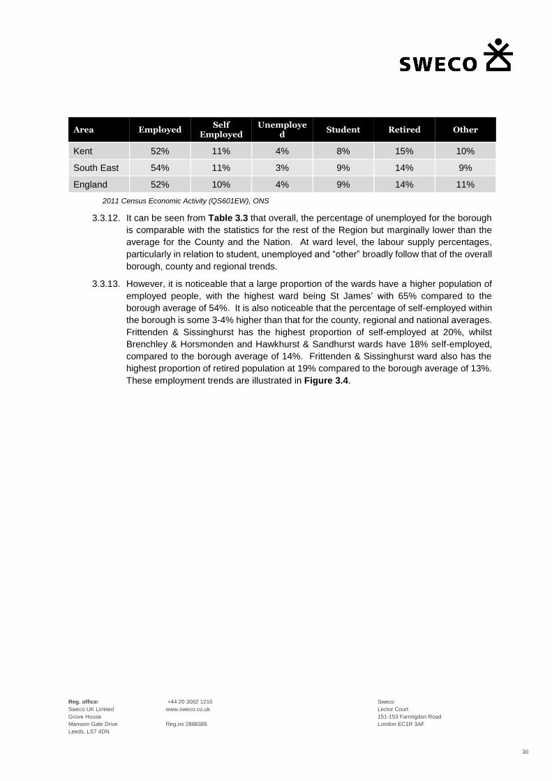
Reg. office:
Sweco UK Limited
Grove House
Mansion Gate Drive
Leeds, LS7 4DN
+44 20 3002 1210
www.sweco.co.uk
Reg.no 2888385
Sweco
Lector Court
151-153 Farringdon Road
London EC1R 3AF
30
Area Employed Self
Employed Unemploye
d Student Retired Other
Kent 52% 11% 4% 8% 15% 10%
South East 54% 11% 3% 9% 14% 9%
England 52% 10% 4% 9% 14% 11%
2011 Census Economic Activity (QS601EW), ONS
3.3.12. It can be seen from Table 3.3 that overall, the percentage of unemployed for the borough
is comparable with the statistics for the rest of the Region but marginally lower than the
average for the County and the Nation. At ward level, the labour supply percentages,
particularly in relation to student, unemployed and “other” broadly follow that of the overall
borough, county and regional trends.
3.3.13. However, it is noticeable that a large proportion of the wards have a higher population of
employed people, with the highest ward being St James’ with 65% compared to the
borough average of 54%. It is also noticeable that the percentage of self-employed within
the borough is some 3-4% higher than that for the county, regional and national averages.
Frittenden & Sissinghurst has the highest proportion of self-employed at 20%, whilst
Brenchley & Horsmonden and Hawkhurst & Sandhurst wards have 18% self-employed,
compared to the borough average of 14%. Frittenden & Sissinghurst ward also has the
highest proportion of retired population at 19% compared to the borough average of 13%.
These employment trends are illustrated in Figure 3.4.

Reg. office:
Sweco UK Limited
Grove House
Mansion Gate Drive
Leeds, LS7 4DN
+44 20 3002 1210
www.sweco.co.uk
Reg.no 2888385
Sweco
Lector Court
151-153 Farringdon Road
London EC1R 3AF
31
Figure 3-4 – Labour Supply for the Wards within Tunbridge Wells Borough (2011)
Census 2011: Economic Activity (QS601EW), ONS
3.3.14. TWBC’s current Transport Strategy document (2015) noted that the 2011 Census
indicated that some 42,500 people commuted in or out of the borough for work and one in
four jobs were held by someone living outside of the borough. Peak hour commuter trips
frequently put pressure on the transport networks across all modes as such, the journey
to work travel patterns for the borough are discussed in greater detail in the following
section of this report.
3.4. Current Travel Behaviour
Car and Van Ownership
3.4.1. Car and van availability can influence a persons’ modal choice and as such, it is important
to gain an understanding of the level and characteristics of car and van ownership across
the borough. Table 3.4 sets out the average car ownership statistics from the 2011
Census at ward, borough, county, regional and national levels.
0
1000
2000
3000
4000
5000
6000
7000
Labour SupplyTunbridge Wells Wards
Employed Self Employed Unemployed Student Retired Other

Reg. office:
Sweco UK Limited
Grove House
Mansion Gate Drive
Leeds, LS7 4DN
+44 20 3002 1210
www.sweco.co.uk
Reg.no 2888385
Sweco
Lector Court
151-153 Farringdon Road
London EC1R 3AF
32
Table 3-4 – Average Car Ownership per Ward, Borough, County, Region and National Levels
Area
No Cars or
Vans in
Household
1 Car or Van in Household
2 Cars or Vans in
Household
3 Cars or Vans in
Household
4 or More Cars or Vans in Household
Beneden & Cranbrook 14% 38% 33% 11% 4%
Brenchley & Horsmonden
6% 32% 40% 14% 7%
Broadwater 22% 48% 22% 5% 2%
Capel 8% 34% 41% 11% 6%
Culverden 26% 50% 20% 3% 1%
Frittenden & Sissinghurst
8% 30% 40% 15% 8%
Goudhurst & Lamberhurst
9% 31% 42% 12% 6%
Hawkhurst & Sandhurst 11% 40% 34% 10% 5%
Paddock Wood East 16% 45% 29% 8% 3%
Paddock Wood West 14% 41% 33% 8% 3%
Pantiles & St Mark’s 15% 49% 28% 6% 2%
Park 22% 50% 22% 4% 1%
Pembury 12% 37% 38% 10% 3%
Rusthall 21% 48% 25% 5% 2%
Sherwood 27% 44% 23% 4% 2%
Southborough & High Brooms
20% 36% 33% 7% 3%
Speldhurst & Bidborough
20% 48% 26% 4% 2%
St James’ 8% 33% 43% 12% 5%
St John’s 27% 50% 19% 3% 0%
Beneden & Cranbrook 17% 49% 27% 6% 2%
Tunbridge Wells Borough
17% 43% 29% 7% 3%
Kent 20% 43% 28% 7% 3%
South East 19% 42% 30% 7% 3%
England 26% 42% 25% 5% 2%
2011 Census Car or Van Availability (QS416EW), ONS

Reg. office:
Sweco UK Limited
Grove House
Mansion Gate Drive
Leeds, LS7 4DN
+44 20 3002 1210
www.sweco.co.uk
Reg.no 2888385
Sweco
Lector Court
151-153 Farringdon Road
London EC1R 3AF
33
3.4.2. Table 3-4 shows that Tunbridge Wells borough has a higher than average car ownership
than those for Kent, the South East Region and England. Indeed, this trend is repeated
within the majority of the individual wards within the borough having a higher average car
ownership in comparison to the County and national averages. The ward with the highest
level of car ownership is Brenchley & Horsmonden with 94% of households having access
to at least one car. Capel, Frittenden & Sissinghurst and St James wards have similar
levels of car ownership of 92% of households having access to at least one car. These
averages are some 10% higher than the borough average.
3.4.3. On average, some 39% of households within the borough have access to two or more
cars. However, it is noted that this is significantly higher in the more rural wards in the
borough namely Beneden & Cranbrook (48%), Brenchley & Horsmonden (62%) Frittenden
& Sissinghurst (63%), Goudhurst & Lamberhurst (60%) and Hawkhurst & Sandhurst
(50%). The wards of Capel (58%), Pembury (51%) and Speldhurst & Bidborough (60%)
also have a significantly higher number of households with access to two or more cars
compared with 38% for Kent, 40% for the South East and just 32% for England on average.
3.4.4. The lowest levels of average car ownership, 1.1 cars per household and below, were in
the wards of Culverden (1.0), Park (1.1), Sherwood (1.1) and St James’ (1.0). These four
wards, which are concentrated around the Royal Tunbridge Wells urban area, have similar
car ownership levels in comparison to the national average. The car ownership levels for
the borough are illustrated in Figure 3.5.

Reg. office:
Sweco UK Limited
Grove House
Mansion Gate Drive
Leeds, LS7 4DN
+44 20 3002 1210
www.sweco.co.uk
Reg.no 2888385
Sweco
Lector Court
151-153 Farringdon Road
London EC1R 3AF
34
Figure 3-5 – Average Car or Van Ownership within Tunbridge Wells Borough (2011)
2011 Census Car or Van Availability (QS416EW), ONS
3.4.5. In summary, car ownership levels in the more urban areas tend to be lower than those in
the more rural wards. It is clear that the car still remains an important form of personal
transport for many in the borough. As such, access to good sustainable travel provision
will need to be a key consideration of future development in order to support sustainable
housing and economic growth in the borough.
Travel to Work Patterns – Resident Population
3.4.6. The level of commuter trips by mode for residents of the borough has been established
from the 2011 Census “Method of Travel to Work” data. This database indicates that,
whilst the level of car ownership within the borough is higher than the regional and national
averages, this does not translate to a higher level of car commuter trips. As set out in
Table 3.5, when excluding those categorised as “Not in Employment”, the level of car
usage as a means of travel to work within the borough (57%) is significantly lower than the
level for the County (66%), Regional (66%) and National (62%) averages.

Reg. office:
Sweco UK Limited
Grove House
Mansion Gate Drive
Leeds, LS7 4DN
+44 20 3002 1210
www.sweco.co.uk
Reg.no 2888385
Sweco
Lector Court
151-153 Farringdon Road
London EC1R 3AF
35
Table 3-5 – Method of Travel to Work – Borough, County, Region and National Averages
Mode of Travel
Tunbridge Wells
Borough Kent County
South East Region
England
All categories Method of travel to work (numbers)
57,234 688,434 4,260,723 25,162,721
Works mainly at or from home
8% 6% 7% 5%
Underground, Metro, light rail, tram
0% 0% 0% 4%
Train 15% 9% 7% 5%
Bus, minibus or coach
2% 4% 4% 7%
Taxi 0% 0% 0% 1%
Motorcycle, scooter or moped
1% 1% 1% 1%
Driving a car or van
53% 61% 61% 57%
Passenger in a car or van
4% 5% 5% 5%
Bicycle 1% 2% 3% 3%
On foot 15% 11% 11% 11%
Other 1% 1% 1% 1%
2011 Census Method of Travel to Work QS701EW, ONS
3.4.7. This lower level of car usage for travel to work from within the borough is considered to
reflect the employment trends of the borough which showed a higher level of self-employed
workers. This, combined with the employment opportunities available within the urban
areas of the borough in particular, result in walking being the joint second most dominant
mode of transport at 15%. This is some 4% higher than the average for Kent, the South
East Region and nationally at 11%.
3.4.8. Similarly, travel by train is equally popular, also accounting for 15% of commuter journeys
from within the borough. This is some 6% higher than the average for Kent and 8% higher
than the South East Region highlighting that out-commuting, to central London in
particular, has an influence on the travel to work modal share patterns for the borough.

Reg. office:
Sweco UK Limited
Grove House
Mansion Gate Drive
Leeds, LS7 4DN
+44 20 3002 1210
www.sweco.co.uk
Reg.no 2888385
Sweco
Lector Court
151-153 Farringdon Road
London EC1R 3AF
36
3.4.9. Travel by bus in Tunbridge Wells borough is low at just 2%. This is half the average levels
for Kent and the South East Region (4%), and significantly lower than that nationally (7%).
Cycling accounts for just 1% of travel to work trips, which is similar to the average for Kent
as a whole but 2% lower than the regional and national averages. This reflects the lack of
well-connected cycle routes and infrastructure within the borough, which are key
influences when choosing this mode of transport.
3.4.10. The Travel to Work modal share for each of the wards within the borough is illustrated in
Figure 3.6.
3.4.11. From Figure 3.6 it can be seen that the modal shares vary across the borough but overall,
car, rail and walk are the dominate modes of transport throughout. Indeed, it is noted that
within the wards located within the central Royal Tunbridge Wells urban area, such as
Pantiles & St Marks, St James, St John’s and Park, the level of trips undertaken by
sustainable modes is higher than that for car. This is to be expected given their proximity
to the town centre and rail stations and the lower levels of car ownership within the wards
as discussed above.

Reg. office:
Sweco UK Limited
Grove House
Mansion Gate Drive
Leeds, LS7 4DN
+44 20 3002 1210
www.sweco.co.uk
Reg.no 2888385
Sweco
Lector Court
151-153 Farringdon Road
London EC1R 3AF
37
Figure 3-6 – Method of Travel to Work – Tunbridge Wells Wards (2011)
2011 Census Method of Travel to Work (QS701EW), ONS
Travel to Work Patterns – Workday Population
3.4.12. The population of an area changes as people move in or out of an area to work. For the
workday population the usual resident population is re-distributed to their places of work,
while those not in work are recorded at their usual residence.
3.4.13. The workday population data series contains statistics about the characteristics of the
workday population. Workday population is an estimate of the population during the
working day for a particular area. It includes everybody who works in an area, wherever
they usually live, and all respondents who live in the area but do not work. It should be
noted that the workday and usual resident population analysis refers to those aged
between 16 and 64. Figure 3.7 shows the difference between the usual population and
the workday (or daytime) population, as recorded by the 2011 Census.
0% 10% 20% 30% 40% 50% 60% 70% 80% 90% 100%
Benenden and Cranbrook
Brenchley and HorsmondenBroadwater
Capel
CulverdenFrittenden and Sissinghurst
Goudhurst and LamberhurstHawkhurst and Sandhurst
Paddock Wood East
Paddock Wood West
Pantiles and St Mark'sPark
PemburyRusthall
Sherwood
Southborough NorthSouthborough and High Brooms
Speldhurst and BidboroughSt James'
St John's
Method of Travel to WorkTunbridge Wells Wards
Work mainly at or from home Underground, metro, light rail, tram Train
Bus, minibus or coach Taxi Motorcycle, scooter or moped
Driving a car or van Passenger in a car or van Bicycle
On foot Other method of travel to work

Reg. office:
Sweco UK Limited
Grove House
Mansion Gate Drive
Leeds, LS7 4DN
+44 20 3002 1210
www.sweco.co.uk
Reg.no 2888385
Sweco
Lector Court
151-153 Farringdon Road
London EC1R 3AF
38
Figure 3-7 – Usual Resident to Workday Population Change (2011)
2011 Census Population (WP101EW), ONS
3.4.14. At the borough level, Tunbridge Wells’ daytime population in 2011 decreased by
approximately 2% and at the County Level the daytime population decreased by 4%.
Indeed, the population was recorded as decreasing within 16 out of the twenty wards within
the borough, with the only exceptions being those listed below:
• Benenden & Cranbrook;
• Culverden;
• Pantile’s & St Mark’s; and
• Park.
3.4.15. The greatest increases in population, within Royal Tunbridge Wells urban area, occur in
Culverden (31%) and Park (66%).
Distance Travelled to Work
3.4.16. Based on the 2011 Census data, the distance travelled to work statistics for the borough
are set out in Table 3.6. It should be noted that ‘distance travelled to work’ in this context
is the distance in kilometres between a person’s residential postcode and their workplace
0
2000
4000
6000
8000
10000
12000
14000
Usual Resident to Workday PopulationTunbridge Wells Wards
Usual Resident Population Workday Population

Reg. office:
Sweco UK Limited
Grove House
Mansion Gate Drive
Leeds, LS7 4DN
+44 20 3002 1210
www.sweco.co.uk
Reg.no 2888385
Sweco
Lector Court
151-153 Farringdon Road
London EC1R 3AF
39
postcode, measured in a straight line. The ‘Other’ category includes no fixed place of work,
working on an offshore installation and working outside of the UK.
Table 3-6 – Distance Travelled to Work Statistics (2011)
Tunbridge
Wells Borough Kent
County South East
Region England
Less than 2km 18% 16.6% 16.57% 16.57%
2km to less than 5km 13% 14% 16% 18%
5km less than 10km 10% 12% 14% 17%
10km less than 20km 10% 13% 14% 15%
20km less than 30km 5% 9% 7% 6%
30km less than 40km 3% 5% 4% 3%
40km less than 60km 13% 5% 4% 2%
60km and over 3% 5% 4% 3%
Work mainly at or from home 14% 11% 12% 10%
Other 9% 9% 9% 8%
Average Distance (km) 19.9 18.9 16.6 14.9
2011 Census Distance Travelled to Work QS702EW, ONS
3.4.17. It can be seen that the average distance travelled to work for the borough as a whole was
higher than that for Kent and significantly higher than that for South East and nationally.
However, whilst the proportion of those travelling less than 2km is higher within Tunbridge
Wells borough than the average for Kent, the proportion of people travelling between 2-
5km, 5-10km and 10-20km is lower than across county, region and nationally. This trend
is repeated for those travelling between 20-30km.
3.4.18. However, whilst the proportion of people travelling between 30-40km is comparable to
Kent, the South East Region and nationally, it is noticeable that the proportion of people
travelling between 40km and 60km (13%) is significantly higher when compared to
regional and national figures for these travel distances (5%, 4% and 2% respectively).
London is approximately between 40km and 60km (straight line distance), depending on
the exact location of work and thus, it is likely that this statistic is due to higher percentages
of residents within the borough out-commuting to Central London.
3.4.19. The ward data is illustrated in Figure 3.8. This shows the number of people travelling from
each ward to work and within each distance band.

Reg. office:
Sweco UK Limited
Grove House
Mansion Gate Drive
Leeds, LS7 4DN
+44 20 3002 1210
www.sweco.co.uk
Reg.no 2888385
Sweco
Lector Court
151-153 Farringdon Road
London EC1R 3AF
40
Figure 3-8 – Distance Travelled to Work Tunbridge Wells Borough Wards (2011)
2011 Census Distance Travelled to Work (QS702EW), ONS
3.4.20. From Figure 3.8 it can be seen that the distance travelled to work varies across the wards,
in some cases quite significantly when compared to the borough average. Indeed, the
average distance travelled to work was higher than the borough average in 8 wards, with
those in Frittenden & Sissinghurst ward travelling the furthest at 27.1km on average,
followed closely by Goudhurst & Lamberhurst at 26.2km. However, this is considered to
be reflective of the geographic locations of these wards within the borough and Kent.
3.4.21. Similarly, it is noticeable that the majority of the people travelling to work from the wards
within/ close to the centre of the Royal Tunbridge Wells urban area are travelling less than
2km, whilst the majority of those within the wards neighbouring Royal Tunbridge Wells are
travelling between 2-5km to work. These patterns are considered to reflect the importance
of Royal Tunbridge Wells as a major employment centre within the borough.
0 1,000 2,000 3,000 4,000 5,000 6,000
Benenden and Cranbrook
Brenchley and Horsmonden
Broadwater
Capel
Culverden
Frittenden and Sissinghurst
Goudhurst and Lamberhurst
Hawkhurst and Sandhurst
Paddock Wood East
Paddock Wood West
Pantiles and St Mark's
Park
Pembury
Rusthall
Sherwood
Southborough North
Southborough and High Brooms
Speldhurst and Bidborough
St James'
St John's
Distance Travelled to WorkTunbridge Wells Wards
Less than 2km 2km to less than 5km 5km to less than 10km
10km to less than 20km 20km to less than 30km 30km to less than 40km
40km to less than 60km 60km and over Work mainly at or from home
Other

Reg. office:
Sweco UK Limited
Grove House
Mansion Gate Drive
Leeds, LS7 4DN
+44 20 3002 1210
www.sweco.co.uk
Reg.no 2888385
Sweco
Lector Court
151-153 Farringdon Road
London EC1R 3AF
41
3.4.22. Notwithstanding, the highest proportion of people travelling between 40-60km to work also
include some of these urban wards and indeed, the wards where the highest proportion of
trips travelling these longer distances are recorded are conveniently located close to rail
stations. These statistics reiterate the boroughs out-commuting trend, particularly to
central London by train. This is illustrated by Figure 3.9 which shows a snap shot of where
people are travelling to work from four locations within Tunbridge Wells borough. It is clear
that the majority of journeys being made to work are to London, especially central London,
with the remainder of the journeys spread throughout the borough and neighbouring
Boroughs and Districts within west Kent.
Figure 3-9 – Direction of Travel to Work from within Tunbridge Wells Borough
Datashine 2019

Reg. office:
Sweco UK Limited
Grove House
Mansion Gate Drive
Leeds, LS7 4DN
+44 20 3002 1210
www.sweco.co.uk
Reg.no 2888385
Sweco
Lector Court
151-153 Farringdon Road
London EC1R 3AF
42
3.4.23. The average distance travelled to work for each of the wards within Tunbridge Wells
borough is shown in Figure 3.10.
Figure 3-10 – Distance Travelled to Work Tunbridge Wells Borough Wards (2011)
2011 Census Distance Travelled to Work (QS702EW), ONS
3.4.24. Figure 3-10 reiterates that in the more rural areas, the distance travelled to work is higher,
whilst those residing in the more urban areas are travelling shorter distances. This is as a
consequence of the greater employment opportunities with the urban areas such as Royal
Tunbridge Wells and Paddock Wood.
0.0 5.0 10.0 15.0 20.0 25.0 30.0
Benenden and Cranbrook
Brenchley and Horsmonden
Broadwater
Capel
Culverden
Frittenden and Sissinghurst
Goudhurst and Lamberhurst
Hawkhurst and Sandhurst
Paddock Wood East
Paddock Wood West
Pantiles and St Mark's
Park
Pembury
Rusthall
Sherwood
Southborough North
Southborough and High Brooms
Speldhurst and Bidborough
St James'
St John's
Average Distance Travelled to Work (km)Tunbridge Wells Wards

Reg. office:
Sweco UK Limited
Grove House
Mansion Gate Drive
Leeds, LS7 4DN
+44 20 3002 1210
www.sweco.co.uk
Reg.no 2888385
Sweco
Lector Court
151-153 Farringdon Road
London EC1R 3AF
43
4. Existing Walking and Cycling Infrastructure
4.1. Introduction
4.1.1. As discussed previously the 2011 Census records that the level of cycling across the
borough is currently low, particularly in comparison to the levels within the wider County
and South East Region. This is acknowledged in both the current Cycling and Transport
Strategies, which comment that this is as a result of real or perceived barriers which put
people off from cycling. These barriers include topography, road safety, cycling
competency and knowledge about routes and parking facilities
4.1.2. However, with the 2017 National Travel Survey (NTS) recording that 24% of trips made
were under 1 mile, and 68% under 5 miles, active travel modes provide an important
opportunity for modal shift from the private car. Therefore, overcoming the real and
perceived barriers to cycling and, to some degree, walking will be a key step in achieving
a modal shift from private car to active travel. Indeed, this is a key aim of the Cycling
Strategy for the borough.
4.1.3. There are numerous benefits to walking and cycling, including to the economy through the
increased movement of people through local streets and routes and to the environment
through the reduction in carbon emissions and congestion as people move from their car,
which in turn provide improved air quality. Walking and cycling also provide the opportunity
to improve public realm and spaces to make them more welcoming, improving social
interaction and enhancing natural surveillance. Fundamentally, facilitating and
encouraging active travel has the potential to support the future housing and economic
growth within the borough.
4.1.4. The provision of adequate infrastructure for pedestrians and cyclists is also a key factor in
modal choice. However, whilst the borough currently has cycle routes that link Royal
Tunbridge Wells town centre to suburban areas, along the A26, A264 and 21st Century
Way (town centre to North Farm), other routes within the urban areas and elsewhere within
the borough are limited. As a result, the borough is characterised by a network of
incomplete cycle routes that are not integrated and there is no continuous cycle route
network throughout the borough. Furthermore, existing junctions and road layouts can
present points of conflict for cyclists and other vehicles and there is a lack of cycle related
facilities at key destinations including stations, schools and Key Employment Areas.
4.1.5. TWBC are currently preparing a Local Cycling and Walking Infrastructure Plan (LCWIP)
and have reviewed a number of walking and cycling corridors to identify schemes for
funding and implementation.
4.2. Cycling Infrastructure
4.2.1. The Cycling Strategy for the borough, whose vision is ‘to make cycling a normal part of
everyday life in the borough, by creating a safe and welcoming environment for cyclists of
all ages and abilities’, seeks to address these existing deficiencies by setting out a series
of Actions and recommendations for new and improved routes.

Reg. office:
Sweco UK Limited
Grove House
Mansion Gate Drive
Leeds, LS7 4DN
+44 20 3002 1210
www.sweco.co.uk
Reg.no 2888385
Sweco
Lector Court
151-153 Farringdon Road
London EC1R 3AF
44
4.2.2. The Cycling Strategy Actions are summarised below:
• Action 1: Infrastructure – A network of high-quality cycle routes will be completed in the
urban areas of Royal Tunbridge Wells, Southborough, Paddock Wood and Cranbrook.
Where possible, inter-urban and leisure cycling routes will be enhanced. Where a
proposed route requires new or upgraded public rights of way, partners will work with the
landowner(s) to secure implementation.
• Action 2: Cycle Parking –
a) Cycle parking will continue to be improved in town and village centres, as well as other
locations including stations, schools, leisure facilities, key bus stops and key employment
areas.
b) Cycle parking will be provided in all commercial and residential developments (both
new build and change of use), secured by partners through the planning process.
• Action 3: Maintenance – KCC and TWBC will work with partners to ensure the regular
maintenance of all cycle routes within the borough.
• Action 4: Cycle Training –
a) All Year 6 children will have access to Level 1 and 2 Bikeability training, and children
in Years 7 to 9 will have access to Level 3 training.
b) Adult cycle training will continue to be offered, through initiatives including work place
travel planning.
• Action 5: Safety – Partners will continue to promote road safety campaigns and
positively consider the introduction of 20mph speed limits and zones in accordance with
KCC policies and procedures.
• Action 6: Promotion and Marketing – KCC and TWBC will ensure cycle routes are fully
advertised and signposted within the borough and that a cycle map and related
information is provided online.
• Action 7: Promotion and Marketing – TWBC and/or the Cycling Forum will continue to
support local cycling events where appropriate.
• Action 8: Monitoring – The Cycling Strategy will be regularly monitored, alongside the
Transport Strategy, to review the implementation of agreed projects and initiatives.
4.2.3. The cycling infrastructure improvements which are to be delivered through the
implementation of the Cycling Strategy 2016-2020 are set out in Chapter 9 of the Strategy
document. These route improvements centre around the Royal Tunbridge Wells urban
area, Paddock Wood and Cranbrook.

Reg. office:
Sweco UK Limited
Grove House
Mansion Gate Drive
Leeds, LS7 4DN
+44 20 3002 1210
www.sweco.co.uk
Reg.no 2888385
Sweco
Lector Court
151-153 Farringdon Road
London EC1R 3AF
45
4.2.4. The route proposals are listed below..
• Tunbridge Wells Area:
• Route 1 – Tonbridge to Tunbridge Wells via the A26
• Route 2 – Pembury to Tunbridge Wells via the A264
• Route 4 – Routes across The Commons
• Route 5 – 21st Century Way including Home Farm Lane link
• Route 6 – Woodsgate Corner to Vauxhall Lane via Tonbridge Road and A21
• Route 7 – Forest Road to Grove Hill Road via Farmcombe Road.
• Route 8 – A26 London Road to Dowding Way via Barnetts Wood
• Route 9 – Langton Green to Tunbridge Wells including Rusthall and Speldhurst
links
• Route 10 – Ramslye and Showfields links
• Paddock Wood:
• Route 3 – Paddock Wood circular route
• Cranbrook:
• Route 11 – High Weald Academy to High Street
4.2.5. In addition to the above urban routes, there are also identified leisure route proposals
which are longer term aspirations supported by the borough Green Infrastructure Plan
SPD (2014). The leisure routes are likely to include both on and off-road alignments
supported by appropriate wayfinding and signage. The proposed leisure routes are listed
below.
• National Cycle Route 18 through Royal Tunbridge Wells town centre
• Tunbridge Wells to Penshurst route (crossing borough boundary)
• Hop Pickers Heritage route (Paddock Wood to Hawkhurst)
• Cranbrook to Sissinghurst route
4.2.6. The need for good cycle routes and facilities associated with new development is
recognised in the TWBC Cycling Strategy which sets out design principles for cycle routes
and infrastructure. These design principles should be incorporated into development and
masterplanning briefs and plans. Indeed, securing funding through development
contributions will be key to ensuring that many of the cycle improvements can be
implemented in the future.
4.3. Walking
4.3.1. Walking remains the most sustainable form of transport and for most people, is a readily
available modal choice, particularly for short journeys. This is reflected in the results of
the 2017 NTS which recorded that walking was the most frequent mode used for short
trips with 81% of trips under one mile being undertaken by foot. Indeed, all transport users
are pedestrians, at least at the start and end of their journeys and as such, the provision

Reg. office:
Sweco UK Limited
Grove House
Mansion Gate Drive
Leeds, LS7 4DN
+44 20 3002 1210
www.sweco.co.uk
Reg.no 2888385
Sweco
Lector Court
151-153 Farringdon Road
London EC1R 3AF
46
of good quality pedestrian environments and infrastructure are crucial to encouraging
walking as an attractive and safe mode of transport.
4.3.2. The borough benefits from an extensive network of footways however, as recognised in
the 2015 Transport Strategy, at many places throughout the borough the pedestrian
environment does not meet the needs of the users. Within Royal Tunbridge Wells, a major
improvement scheme at Fiveways including wider footways, cycle parking, new street
furniture and extended hours for vehicular restriction was completed within 2015 and that
further phases of work to Mount Pleasant Road, Vale Road and High Street would be
completed in the period of the Transport Strategy.
4.3.3. During the public consultation for the Transport Strategy a number of particular issues at
both rural and urban locations were identified. With reference to Paragraph 4.94 of the
Transport Strategy, these issues are set out below:
• ‘A26 London Road, Tunbridge Wells, constraints at junctions with Church Road, Major
Yorks Road and High Street, insufficient or lack of shared use crossing facilities.
• ‘A264 Langton Road and Mount Ephraim, lack of shared use crossings.
• ‘A262 Station Road, Goudhurst, between the junction of Ranters Lane and Blue Coat
Lane, pedestrian footpaths required.
• ‘A262 provision of footways on routes to the north and pedestrian crossing point
associated with Goudhurst and Kilndown primary school.
• ‘A262 Cranbrook Road, between the junction of Tattlebury Lane and Chequers Road.
• ‘B2079 North Road/Bedgebury Road, lack of provision for cyclists and poor pedestrian
footway, further speed limit reduction is being sought.’
4.3.4. Complementing the boroughs’ extensive network of footways is some 365 miles of Public
Rights of Way (PRoW) in the borough including footpaths, bridleways, byways and
restricted byways which means that leisure walking in particular is very accessible and
attractive with tourists and walking groups. However, these ProWs also have the potential
to play an important role in assisting and facilitating pedestrian movement through the
borough for a variety of trip purposes, including commuting, and thus, in turn helping to
get people out of their cars.
4.3.5. This forms a key consideration of the Tunbridge Wells Borough Green Infrastructure Plan
SPD, adopted 2014, the aim of which is not just the creation of new green spaces, but also
the enhancement of existing green infrastructure assets. The Green Infrastructure Plan
SPD policies aim to contribute to vision and objectives of the Plan by:
• ‘Conserving, enhancing or creating local and regional networks of green infrastructure in
order to link assets within and between boroughs and connect urban areas with the
surrounding countryside.
• ‘Enhancing the multi-functionality if existing green infrastructure assets and seeking the
creation of new multi-functional spaces and/or linkages where a need or deficiency has
been identified.

Reg. office:
Sweco UK Limited
Grove House
Mansion Gate Drive
Leeds, LS7 4DN
+44 20 3002 1210
www.sweco.co.uk
Reg.no 2888385
Sweco
Lector Court
151-153 Farringdon Road
London EC1R 3AF
47
• ‘Conserving and enhancing the network of existing access routes to allow sustainable
commuting, providing safe, attractive and well-signed walking and cycling options for all,
including those with disabilities.’
4.3.6. The borough already benefits from an extensive network of green infrastructure, as
touched upon above, including the National Cycle Route 18, and the High Weald
Landscape Trail and Tunbridge Wells Circular Walk long distance walking routes.
However, connectivity is not always ideal and some of these routes are not attractive for
all user groups. As such, Chapter 6 of the Green Infrastructure Plan SPD (2014) sets out
a number of specific spatial proposals, including existing projects and those that could be
delivered alongside new development, designed to address the deficiencies in access and
infrastructure. An abridged summary of the proposals relating to access is provided below:
• Proposal 2: High Weald/Low Weald Links – Links between the High Weald and the
Low Weald character areas involving improving links and signage across the existing
droveways to enhance sustainable transport routes.
• Proposal 5: Enhancement of links between key tourist attractions and settlements
– Improvement of links from the Borough's key centres, including Royal Tunbridge Wells,
Cranbrook and Hawkhurst to key tourist attractions, for example Bedgebury Pinetum and
Bewl Water in order to increase connectivity and provision of more accessible and safer
off-road routes for pedestrians, cyclists and equestrians between settlements and tourist
attractions.
• Proposal 7: Redundant Railways - Within the eastern part of the Borough, along the
former Paddock Wood to Hawkhurst Railway, which connected Hawkhurst, Cranbrook,
Goudhurst, Horsmonden and Paddock Wood. Within the western part of the Borough,
along the former Tunbridge Wells to Eridge line.
4.3.7. With regards to Proposal 7, the other redundant railway line within the Borough runs from
Tunbridge Wells West through to Eridge and remains a safeguarded transport route in the
Local Plan and emerging Site Allocations DPD10. It is noted that land ownership is a
significant barrier to the transforming of redundant railways lines, however development
may help in securing improvements.
4.3.8. Indeed, as stated within the existing TWBC policy documents, the provision of green
infrastructure should be an integral part of new development that not only provides new
facilities within the boundaries of the development, but also improves connectivity and
continuity of existing green infrastructure routes and assets.
10 TWBC Green Infrastructure Plan Supplementary Planning Document (2014), Paragraph 7.29

Reg. office:
Sweco UK Limited
Grove House
Mansion Gate Drive
Leeds, LS7 4DN
+44 20 3002 1210
www.sweco.co.uk
Reg.no 2888385
Sweco
Lector Court
151-153 Farringdon Road
London EC1R 3AF
48
5. Existing Public Transport Infrastructure and Level of Service
5.1. Introduction
5.1.1. In order to assist in the analysis of existing public transport infrastructure and Level of
Service, the borough has been divided into four sectors for review. Each sector is
comprised of a number of census Middle Layer Super Output Areas (MSOA) boundaries.
The sectors have been split as follows:
• East – includes A229 corridor, as well as Hawkhurst and Cranbrook
• Central – predominantly based upon the A21 corridor, including Pembury, Lamberhurst,
and Goudhurst
• North – focuses on Paddock Wood
• West – based around Royal Tunbridge Wells urban area, including Southborough
5.1.2. This work has also taken account of the location of proposed Local Plan site allocations to
aid future year mitigation analysis work. The resultant adopted sectors are illustrated in
Figure 5.1.

Reg. office:
Sweco UK Limited
Grove House
Mansion Gate Drive
Leeds, LS7 4DN
+44 20 3002 1210
www.sweco.co.uk
Reg.no 2888385
Sweco
Lector Court
151-153 Farringdon Road
London EC1R 3AF
49
Figure 5-1 – Baseline Analysis – Tunbridge Wells Borough Sectors
5.2. Tunbridge Wells Borough – East
5.2.1. A number of key towns, villages, and local settlements make up the east of Tunbridge
Wells borough. The key locations, based around an average density of persons per square
kilometre (using Census 2017 population updates), have been identified in Figure 5.2.

Reg. office:
Sweco UK Limited
Grove House
Mansion Gate Drive
Leeds, LS7 4DN
+44 20 3002 1210
www.sweco.co.uk
Reg.no 2888385
Sweco
Lector Court
151-153 Farringdon Road
London EC1R 3AF
50
Figure 5-2 – Tunbridge Wells Borough East Region - Existing Larger Urban Settlements based
on Average Density per square km (2017 Population)
5.2.2. The larger urban areas are Cranbrook and Hawkhurst. Other notable urban settlements
include Sissinghurst and Benenden. Smaller urban settlements in the area are Sandhurst
and Frittenden. As set out in Para 1.5.1, this report was based on provisional information
during the formation of the Local Plan. The development locations within this area based
on this provisional information are outlined in Figure 5-3, although these vary in the Draft
Local Plan, the overall numbers in the plan are broadly consistent:
• Hawkhurst 680
• Cranbrook 540
• Sissinghurst 230
• Benenden 220

Reg. office:
Sweco UK Limited
Grove House
Mansion Gate Drive
Leeds, LS7 4DN
+44 20 3002 1210
www.sweco.co.uk
Reg.no 2888385
Sweco
Lector Court
151-153 Farringdon Road
London EC1R 3AF
51
Figure 5-3 – Tunbridge Wells Borough East Region – New Local Plan Sites
Bus
5.2.3. There are a number of bus routes of varying frequency which serve the eastern part of
Tunbridge Wells borough. Of these, there are considered to be four primary bus routes
which offer the greatest frequency over the whole day. In addition, two bus services have
been identified that may offer some additional accessibility for people on the periphery of
the borough boundary. The routing of these key routes is illustrated on Figure 5.4.

Reg. office:
Sweco UK Limited
Grove House
Mansion Gate Drive
Leeds, LS7 4DN
+44 20 3002 1210
www.sweco.co.uk
Reg.no 2888385
Sweco
Lector Court
151-153 Farringdon Road
London EC1R 3AF
52
Figure 5-4 – Bus Routings – Tunbridge Wells Borough – Eastern Region
5.2.4. Routes 254/304/305 are effectively one route for the region. The section of the route from
Hawkhurst to Royal Tunbridge Wells is served under route number 254, whilst the
connection from Hawkhurst to Hastings via Robertsbridge is route 304/305. The route runs
hourly weekdays, approximately 7am to 7pm, with no Sunday service. The service offers
key connections from Hawkhurst to Royal Tunbridge Wells and Hastings. It also offers a
rail connection to the Hastings Main Line at Wadhurst and to Tunbridge Wells central
stations.
5.2.5. For connecting trips to London, the quickest connection by bus plus rail from Hawkhurst is
via route 254 and changing at Wadhurst. This offers wider accessibility from Hawkhurst,
to Tonbridge, Sevenoaks, and London in particular.
5.2.6. Route 349 also connects Hawkhurst to Hastings, via Sandhurst and Sedlescombe. This
service directly links with the 254 from Hawkhurst to Royal Tunbridge Wells. It runs every
2 hours, approximately 7am to 6pm. It also operates on Sundays. All these services are
operated by Stagecoach.
Key:
254/304/305
349
5
297
2
12
Railway Stations

Reg. office:
Sweco UK Limited
Grove House
Mansion Gate Drive
Leeds, LS7 4DN
+44 20 3002 1210
www.sweco.co.uk
Reg.no 2888385
Sweco
Lector Court
151-153 Farringdon Road
London EC1R 3AF
53
5.2.7. Route 5, operated by Arriva, offers a key north south connection through the region,
primarily via the A229. It links Sandhurst, Hawkhurst, Cranbrook, and Sissinghurst to the
South Eastern Main Line at Staplehurst and Maidstone town. The service operates hourly,
with services Monday to Saturday between Sandhurst and Maidstone. On Sundays the
service only runs between Cranbrook and Maidstone. During peak times in the weekday,
the service operates approximately every 30 minutes. S106 funding to make
improvements to Route 5 has been received from development in Hawkhurst.
5.2.8. A high-level analysis on rail journey times and connection times highlights that connecting
to the rail network at Staplehurst from Cranbrook and Sissinghurst offers the quickest
journey times to London.
5.2.9. Route 297, operated by Renown Group, runs east-west through the centre of the region.
The route connects from Tenterden in Ashford District to Royal Tunbridge Wells via
Cranbrook, Horsmonden, and Pembury. It offers a direct connection from Cranbrook, and
via a short walk from Sissinghurst, a direct connection to Royal Tunbridge Wells. The
service operates approximately every 90 minutes from 7am to 7pm, with no Sunday
service.
5.2.10. Route 2 and Route 12 both operate in Ashford District. They offer the potential for some
localised connections from Royal Tunbridge Wells borough through cycle/walk/pick up for
people living near the boundary in areas like Frittenden and Benenden.
5.2.11. The summary of census trip demand of bus used as primary mode is shown in Figure 5.5.
The map highlights that the key bus corridors for trips within the east region, are trips
between Royal Tunbridge Wells, Maidstone, Ashford District, and East Sussex/Hastings.
The map also highlights that a total bus demand for the region of 143 trips indicates that
there is only a 2% mode share for bus trips to and from work in the eastern region.

Reg. office:
Sweco UK Limited
Grove House
Mansion Gate Drive
Leeds, LS7 4DN
+44 20 3002 1210
www.sweco.co.uk
Reg.no 2888385
Sweco
Lector Court
151-153 Farringdon Road
London EC1R 3AF
54
Figure 5-5 Tunbridge Wells Borough East Region – Bus Trip Demand and Distribution
5.2.12. There a number of additional bus services that serve the region on a low frequency basis.
These services offer links for school children to schools in Royal Tunbridge Wells and
Tonbridge, as well bus services to market towns that depart once a week. The services
are summarised in Table 5.1.

Reg. office:
Sweco UK Limited
Grove House
Mansion Gate Drive
Leeds, LS7 4DN
+44 20 3002 1210
www.sweco.co.uk
Reg.no 2888385
Sweco
Lector Court
151-153 Farringdon Road
London EC1R 3AF
55
Table 5-1 – Tunbridge Wells Borough East Region – Low Frequency Bus Services
Route Operator Route Operating Days
24 Hams Travel Sandhurst - Headcorn - Maidstone Tuesdays only
254 Hams Travel Uplands Community College - Tunbridge Wells
Schooldays
255 Autocar Bus & Coach Services
Benenden - Hawkhurst - Lamberhurst - Pembury - Tunbridge Wells
Schooldays and Friday services
267 Hams Travel Hawkhurst - Cranbrook - Goudhurst - Paddock Wood - Tunbridge Wells Boys'
Grammar
Schooldays
268 Hams Travel Hawkhurst - Cranbrook - Goudhurst - Paddock Wood - Tonbridge Schools
Schooldays
292 Hams Travel Hawkhurst - Sandhurst - Rolvenden - Tenterden
Schooldays and Friday services
293 Hams Travel Tunbridge Wells - Lamberhurst - Hawkhurst - Rolvenden - Tenterden
Thursday only
299 Hams Travel Tonbridge - Pembury - Lamberhurst - Hawkhurst - Tenterden
Friday only
HC Hams Travel Linton - Headcorn - High Weald Academy Schooldays
Rail
5.2.13. There are no rail stations directly in this region of Tunbridge Wells borough. However, both
the Hastings Line and the South Eastern Main Line have stations close to the borough
boundary. Overall, the rail mode share for this area is 8% (634). Of these trips, 85% of
trips connect to work in London, with an additional 2% going in the opposite direction. The
remaining rail demand include trips to/from Royal Tunbridge Wells (2%), Tonbridge (2%),
Maidstone (1%), and Ashford (1%).
5.2.14. The key stations for the region are outlined in Figure 5.6.

Reg. office:
Sweco UK Limited
Grove House
Mansion Gate Drive
Leeds, LS7 4DN
+44 20 3002 1210
www.sweco.co.uk
Reg.no 2888385
Sweco
Lector Court
151-153 Farringdon Road
London EC1R 3AF
56
Figure 5-6 – Tunbridge Wells Borough East Region – Key Railway Stations
5.2.15. A high-level analysis of rail provision in the area is summarised in Table 5.2.
Wadhurst
Stonegate
Etchingham

Reg. office:
Sweco UK Limited
Grove House
Mansion Gate Drive
Leeds, LS7 4DN
+44 20 3002 1210
www.sweco.co.uk
Reg.no 2888385
Sweco
Lector Court
151-153 Farringdon Road
London EC1R 3AF
57
Table 5-2 – Tunbridge Wells Borough East Region – Key Railway Station Data
Station Main Line
ORR Demand 2017/201
8
Bicycle Parking
Parking Spaces
AM Peak to London (Train per
hour)
Fastest (mins)
Slowest (mins)
Wadhurst Hastings
Line 397,214 20 318 4 62 68
Stonegate Hastings
Line 180,222 14 145 3 69 80
Etchingham
Hastings Line
246,666 40 189 4 75 85
Staplehurst
South Eastern
Main Line
836,502 66 452 6 52 59
Headcorn
South Eastern
Main Line
594,084 28 456 6 57 64
5.2.16. The station with the highest rail demand in this region is Staplehurst (circa. 840,000
passengers), followed by Headcorn (circa. 590,000 passengers), with both stations
located on the South Eastern Main Line. The highest demand station on the Hastings Line
in the region is Wadhurst (circa. 400,000 passengers).
5.2.17. Table 5.2 also shows that the highest level of car parking spaces to connect to rail are at
Staplehurst and Headcorn stations. This suggests the majority of rail trips from the East
Region will connect to rail on the South Eastern Main Line. The closest connection for the
Hastings Line is at Etchingham, which has just 189 spaces.
5.2.18. Cycle rail connections for the east region appear limited. The cycle time from Hawkhurst
to Etchingham is approximately 30 minutes (8km) and is currently without a dedicated
cycle corridor. The situation for cycling from Sissinghurst to Staplehurst is very similar, with
Cranbrook a further 5 minutes cycle from the station.
5.2.19. Bus rail connectivity is likely to be limited to the use of route 254 to Hastings Line via
Wadhurst and route 5 to the South Eastern Main Line via Staplehurst. The bus journey
time for route 254 to Wadhurst station is 30 minutes. The bus journey time for route 5 from
Staplehurst station is 13 minutes to Sissinghurst and 16 minutes to Cranbrook. The shorter
journey times are likely to make this link attractive to use for people connecting to and from
Cranbrook/Sissinghurst.
Cycling and Walking
5.2.20. Cycling and walking trips in the east region are limited mainly by the geographic constraints
involving long distances between larger settlements, but also as a result of a lack of
suitable infrastructure in the area.

Reg. office:
Sweco UK Limited
Grove House
Mansion Gate Drive
Leeds, LS7 4DN
+44 20 3002 1210
www.sweco.co.uk
Reg.no 2888385
Sweco
Lector Court
151-153 Farringdon Road
London EC1R 3AF
58
5.2.21. A total of 9% (693) of trips are being made on foot in the east region. This is significantly
more than bus and cycling, and also higher than rail mode share for this region. The trips
are likely to be focused in and around the main urban settlements of Hawkhurst and
Cranbrook/Sissinghurst. This is aided by a network of pavements and a number of services
within a short walk of people’s homes. From a high-level review of existing footpaths next
to major roads in the area (A268 and A229) it does not appear that there is a coherent
network of pedestrian facilities between settlements.
5.2.22. Only 1% of trips (56) are made by bicycle. This low mode share is likely to be down to poor
cycle infrastructure and the convenience of driving. Roads don’t provide cyclists with
dedicated space and vehicle speeds are potentially high along the rural roads. The only
signed cycle route through the east region is the National Cycle Network Route 18. This
provides some sections of off-road cycling and use of low traffic links. However, the NCN
route is more focused on leisure use and does not directly link to either Hawkhurst,
Cranbrook, or Sissinghurst.
Key Findings from Baseline Review – Tunbridge Wells Borough East Region
5.2.23. The preceding information has been related back to the new development locations. This
section outlines potential opportunities and limitations for connecting in new developments
to sustainable transport in the east region.
5.2.24. As illustrated in Figure 5.7, the majority of the new development site locations (ringed in
green) are on, or within walking distance, of existing bus and cycle corridors. The sites
within Hawkhurst, Sandhurst, Cranbrook, and Sissinghurst reinforce the existing bus
services and corridors along the A229 and A268. This will have a positive effect on bus
demand along these corridors, which also offer routes to multiple areas of interest including
Royal Tunbridge Wells, Maidstone, and Hastings. The potential increase in demand could
allow bus operators to run additional services during the day and into the evening. In
addition, with the high demand for rail to London in the area, and with buses linking to
these rail corridors at Wadhurst and Staplehurst, it is expected that this will further increase
new bus demand in the area.
5.2.25. Furthermore, Benenden is connected by bus route 297 which offers links to Cranbrook,
Pembury, Royal Tunbridge Wells, and Ashford District. However, with just this one bus
service, at an average frequency of once every 90 minutes, the developments in this area
will have limited potential to reduce car mode share for the east region.
5.2.26. Any development at Benenden Hospital will not be on a pre-existing bus corridor. It is also
difficult to see commercial bus services using these roads in the future. This area is
however served by the NCN Route 18, but this route will require additional work to bring it
up to standard to support utility use and use by people of all ages and abilities. In addition,
it does not connect directly to either Cranbrook or Hawkhurst, which is likely to limit its
appeal and benefits.
5.2.27. Frittenden is not located on either a bus service or signed or proposed cycle corridor.

Reg. office:
Sweco UK Limited
Grove House
Mansion Gate Drive
Leeds, LS7 4DN
+44 20 3002 1210
www.sweco.co.uk
Reg.no 2888385
Sweco
Lector Court
151-153 Farringdon Road
London EC1R 3AF
59
Figure 5-7 – Tunbridge Wells Borough East Region – Baseline Map - Location of New
Development Sites in Relation to Sustainable Transport Network
5.2.28. Key corridors that connect the key urban centres in the region, in particular the north south
A229 and the east west A268, have gaps in footpath and cycle link provision. There are
currently no coherent continuous cycle/walk links between the largest urban settlements
in the area. This currently limits the opportunity for trips between existing urban settlements
to be undertaken by active travel modes, as well as to some of the new development sites
on the A229 and A268 corridors.
5.2.29. The latest cycling strategy include some cycle path proposals within the east region,
primarily those described below. However, these do not cover a full regional network.
• Hop Pickers Link – A229 to Paddock Wood (though detail planning not undertaken for
Paddock Wood section)
• Utility links – within Cranbrook, and between Cranbrook and Sissinghurst
Bus:
254/304/305
349
5
297
2
12
Rail:
Station
Cycling:
Existing
NCN Route 18
Proposed
Hop Pickers
Cycling Strategy

Reg. office:
Sweco UK Limited
Grove House
Mansion Gate Drive
Leeds, LS7 4DN
+44 20 3002 1210
www.sweco.co.uk
Reg.no 2888385
Sweco
Lector Court
151-153 Farringdon Road
London EC1R 3AF
60
5.2.30. Car parking at Etchingham and Staplehurst rail stations in particular may come under
increased pressure as a result of rail trips from new developments. There is a bus
connection from the east region to Staplehurst, though bus frequency is only hourly.
Etchingham is not currently connected to the east region by bus, with the closest bus rail
link on the line being at Wadhurst Station, located further away.
5.2.31. In summary, the baseline analysis has identified the following issues that require review
for the east region in relation to integrating the new development sites:
• At only 2% mode share for the east region, bus services will need to have frequency and
priority improvements to make it a viable option for people in existing and new
developments.
• The key existing bus corridor is Hawkhurst – Cranbrook – Sissinghurst. This corridor sees
the majority of proposed development growth as a result of new development.
• Rail constitutes 8% of trips to work for the east region, and yet there is no station in the
region itself. This highlights the pressure on connecting modes for rail travel. Key rail
stations, Etchingham and Staplehurst, will see additional pressure on car parking and
station capacity as a result of the new development if existing trip patterns are
maintained, with the dominant trip pattern for rail trips to London.
• Bus alternatives to car access are stronger for the South Eastern Main Line, which
Staplehurst is on. However, frequency and coverage from new development sites are still
a concern with existing bus network coverage. Access by bus to the Hastings Line is
more constrained with a reliance on the link to Wadhurst which is further in distance from
the area than Etchingham.
• Currently, cycling would not be seen as a viable option for most existing and future
development trips due both to distances and lack of quality infrastructure and connected
network.
• Walking is strong within town/village centres (currently at 9% of total journey to work
mode share) and some new development should be able to take advantage of the
existing infrastructure to promote active trips to and from the new sites within the urban
areas. However inter settlement walk and cycle trips are limited by the lack of continuous
dedicated links and paths for both modes.
• Frittenden and Benenden Hospital sites are not well served by bus or cycle/walk routes.
As such, without improvements, car trips will dominate to and from these proposed sites.
5.3. Tunbridge Wells Borough – Central Region
5.3.1. A number of key towns, villages, and local settlements make up the Tunbridge Wells
borough central region. The key locations, based around an average density of persons
per square kilometre using Census 2017 population updates, have been identified in
Figure 5.8.

Reg. office:
Sweco UK Limited
Grove House
Mansion Gate Drive
Leeds, LS7 4DN
+44 20 3002 1210
www.sweco.co.uk
Reg.no 2888385
Sweco
Lector Court
151-153 Farringdon Road
London EC1R 3AF
61
Figure 5-8 – Tunbridge Wells Borough Central Region - Existing Larger Settlements based on
Average Density per km (2017 Population)
5.3.2. The largest urban area is Pembury. This includes Tunbridge Wells Hospital. Other notable
settlements within the central region are Lamberhurst, Goudhurst, and Horsmonden.
5.3.3. Within this context, the Local Plan development strategy is to develop within boundaries
of these and other existing urban settlements in the area. As set out in Para 1.5.1, this
report was based on provisional information during the formation of the Local Plan. The
development locations within this area based on this provisional information are outlined
in Figure 5-9, although these vary in the Draft Local Plan, the overall numbers in the plan
are broadly consistent:
• Pembury 1,350
• Matfield 1,150

Reg. office:
Sweco UK Limited
Grove House
Mansion Gate Drive
Leeds, LS7 4DN
+44 20 3002 1210
www.sweco.co.uk
Reg.no 2888385
Sweco
Lector Court
151-153 Farringdon Road
London EC1R 3AF
62
• Horsmonden 530
Figure 5-9 – Tunbridge Wells Borough Central Region - New Local Plan Sites
Bus
5.3.4. There are a number of bus routes of varying frequency which serve the central region. Of
these, there are considered to be approximately ten primary bus routes which offer the
greatest frequency over the whole day. In addition, this assessment has identified bus
services that run as route variations to the main routes, mainly during weekdays. The
routing of these key routes is illustrated on Figure 5.10.

Reg. office:
Sweco UK Limited
Grove House
Mansion Gate Drive
Leeds, LS7 4DN
+44 20 3002 1210
www.sweco.co.uk
Reg.no 2888385
Sweco
Lector Court
151-153 Farringdon Road
London EC1R 3AF
63
Figure 5-10 – Bus Routings – Tunbridge Wells Borough Central Region
5.3.5. Route 6/6A connects between Maidstone and Royal Tunbridge Wells via Pembury,
Paddock Wood and East Peckham. The 6A route variation terminates at Hale Street, East
Peckham. The route has an average weekday frequency of every 30 minutes, between
approximately 7am to 9pm. It runs 7 days a week, though some of the services on Sunday
in particular are truncated between Tunbridge Wells Hospital and Royal Tunbridge Wells.
The service offers key rail connections to the Hastings Main Line at Tunbridge Wells
Central and Paddock Wood station for the South Eastern Main Line. The service is
operated by Arriva Kent & Surrey.
5.3.6. Route 6X, which is also operated by Arriva Kent & Surrey, connects Tunbridge Wells
Hospital with Maidstone Hospital. It runs every 45 minutes, approximately 6am to 9pm
Monday to Sundays. However, weekends see reduced service frequency.
5.3.7. Route 23, another Arriva Kent & Surrey service, offers a key north south connection
through the central region to the east. It links Goudhurst to the South Eastern Main Line
Key:
6
6A
6X
23
208
218
256
277
283
296
297
Railway Stations

Reg. office:
Sweco UK Limited
Grove House
Mansion Gate Drive
Leeds, LS7 4DN
+44 20 3002 1210
www.sweco.co.uk
Reg.no 2888385
Sweco
Lector Court
151-153 Farringdon Road
London EC1R 3AF
64
at Marden (15-minute connection time) and Maidstone town. The service operates every
90 minutes on weekdays to Goudhurst, with services Monday to Saturday.
5.3.8. Route 208/209 runs from Pembury to Tonbridge with route 208 continuing on north to
serve Cage Green, Golden Green, and East Peckham. The route offers direct connections
to Tonbridge town centre and railway station. The combined service operates
approximately every 30 minutes between Pembury and Tonbridge 9am to 4pm, with
additional hourly 208 services in the morning and until 7pm in the evening. There is no
Sunday service. It is operated by Autocar Bus and Coach Services Group.
5.3.9. Route 218/219 connects Tunbridge Wells Hospital (Pembury) to Cage Green (Tonbridge).
Some services start from North Farm business and leisure park before servicing the
hospital. Overall the services offer a 30-minute frequency. The service runs Monday to
Sunday up to 8pm and is operated by Arriva Kent & Surrey.
5.3.10. Route 277 (the Sherwood Shuttle) is a high frequency bus route that connects Tunbridge
Wells Hospital (Pembury) to Royal Tunbridge Wells town centre via North Farm business
and leisure park. Services runs Monday to Sunday, up to 11pm during weekdays. It is also
operated by Arriva Kent & Surrey.
5.3.11. Route 283 also offers a 30minute frequency bus route that connects Tunbridge Wells
Hospital (Pembury) to Royal Tunbridge Wells town centre via North Farm business and
leisure park. This service runs Monday to Saturday, 9pm to 5pm and is operated by Go
Coachhire.
5.3.12. Route 296 offers a 120-minute frequency between 9pm and 3pm that connects Paddock
Wood to Royal Tunbridge Wells via Horsmonden and Pembury. It is operated by Autocar
Bus and Coach Services Group. It does not run on Sundays.
5.3.13. Route 297 runs east west through the centre of the central region. The route connects
from Tenterden in Ashford District to Royal Tunbridge Wells via Cranbrook, Horsmonden,
and Pembury. It offers a direct connection from Cranbrook, and via a short walk from
Sissinghurst, a direct connection to Royal Tunbridge Wells town centre. The service
operates approximately every 90 minutes from 7am to 7pm, with no Sunday service. It is
operated by Renown Group.
5.3.14. The trip demand for bus as the primary mode is shown in Figure 5.11 (based on Census
data). The map highlights that the key bus corridors for trips within the central region, are
trips between Royal Tunbridge Wells, Tondridge, Maidstone, and East Sussex/Hastings.
The map also highlights that total bus trip demand for trips to work for the central region is
210. This equates to a 2% mode share for bus trips to and from work in this region of the
borough.

Reg. office:
Sweco UK Limited
Grove House
Mansion Gate Drive
Leeds, LS7 4DN
+44 20 3002 1210
www.sweco.co.uk
Reg.no 2888385
Sweco
Lector Court
151-153 Farringdon Road
London EC1R 3AF
65
Figure 5-11 Tunbridge Wells Borough Central Region – Bus Trip Demand and Distribution
5.3.15. There a number of additional bus services that serve the region on a low frequency basis.
These services offer links for school children to schools in Royal Tunbridge Wells and
Tonbridge, as well as bus services to market towns that depart once a week. The services
are summarised in Table 5.3.

Reg. office:
Sweco UK Limited
Grove House
Mansion Gate Drive
Leeds, LS7 4DN
+44 20 3002 1210
www.sweco.co.uk
Reg.no 2888385
Sweco
Lector Court
151-153 Farringdon Road
London EC1R 3AF
66
Table 5-3 – Tunbridge Wells Borough Central Region – Low Frequency Bus Services
Route Operator Route Operating Days
3 Hams Travel Lamberhurst - Pembury - Tonbridge Hillview School
Schooldays
4 Hams Travel Weald Of Kent School - Tunbridge Wells - Lamberhurst - Flimwell
Schooldays
4 Brookline Aylesford - Leybourne - Kings Hill - East Peckham - Bennett Memorial School
Schooldays
209 Autocar Bus &
Coach Services Pembury - Tonbridge
Weekdays
255 Autocar Bus &
Coach Services Benenden - Hawkhurst - Lamberhurst - Pembury - Tunbridge Wells
Schooldays and Friday services
258 Hams Travel Bells Yew Green - Lamberhurst - Kilndown - Uplands Community College
Schooldays
266 Autocar Bus &
Coach Services Kilndown - Lamberhurst - Wateringbury - Maidstone
Tuesday only
267 Hams Travel Hawkhurst - Cranbrook - Goudhurst - Paddock Wood - Tunbridge Wells Boys' Grammar
Schooldays
268 Hams Travel Hawkhurst - Cranbrook - Goudhurst - Paddock Wood - Tonbridge Schools
Schooldays
287 Autocar Bus &
Coach Services Mascalls School - Pembury - Tunbridge Wells
Schooldays
293 Hams Travel Tunbridge Wells - Lamberhurst - Hawkhurst - Rolvenden - Tenterden
Thursday only
299 Hams Travel Tonbridge - Pembury - Lamberhurst - Hawkhurst - Tenterden
Friday only
TWM Hams Travel Mascalls School - Pembury - Tunbridge Wells
Schooldays
Rail
5.3.16. There are no rail stations within this region of Tunbridge Wells. However, there are stations
on the Hastings Line and the South Eastern Main Line nearby. Overall, the rail mode share
for this area is 10% (931). This is the highest mode share for any of the non-car modes in
the central region. Of these trips, 83% of trips connect to and from London. Of the
remaining rail demand, Tonbridge and Malling is a key destination (2%).
5.3.17. The key stations for the central region are outlined in Figure 5.12.

Reg. office:
Sweco UK Limited
Grove House
Mansion Gate Drive
Leeds, LS7 4DN
+44 20 3002 1210
www.sweco.co.uk
Reg.no 2888385
Sweco
Lector Court
151-153 Farringdon Road
London EC1R 3AF
67
Figure 5-12 – Tunbridge Wells Borough Central Region – Key Railway Stations
5.3.18. A high-level analysis of rail provision in the area is summarised in Table 5.4.
Key:
6
6A
6X
23
208
218
256
277
283
296
297
Railway Stations
Tunbridge Wells Central
Frant
Wadhurst
Marden
Paddock
Wood
High Brooms
Tonbridge

Reg. office:
Sweco UK Limited
Grove House
Mansion Gate Drive
Leeds, LS7 4DN
+44 20 3002 1210
www.sweco.co.uk
Reg.no 2888385
Sweco
Lector Court
151-153 Farringdon Road
London EC1R 3AF
68
Table 5-4 – Tunbridge Wells Borough Central Region – Key Railway Station Data
Station Main Line
ORR Demand 2017/201
8
Bicycle Parking
Parking Spaces
AM Peak to London (Train per
hour)
Fastest (mins)
Slowest (mins)
High Brooms
Hastings Line
1,224,846 20 52 6 48 59
Tunbridge Wells Central
Hastings Line
3,679,224 118 297 6 52 63
Frant Hastings
Line 139,768 12 109 3 58 74
Wadhurst Hastings
Line 397,214 20 318 4 62 68
Tonbridge South
Eastern Main Line
4,391,184 220 716 9 33 40
Paddock Wood
South Eastern
Main Line 1,181,218 96 481 6 41 49
Marden South
Eastern Main Line
540,068 10 177 6 47 55
5.3.19. The station with the highest rail demand in this region is Tonbridge (circa. 4.4 million),
located on the South Eastern Main Line, followed by Tunbridge Wells Central (circa. 3.7
million), on the Hastings Line.
5.3.20. Table 5.4. shows that the stations with the highest level of car parking spaces are at
Tonbridge, Paddock Wood, and Wadhurst. This suggests the majority of rail trips from the
Central Region will connect to rail on the South Eastern Main Line, but that the Hastings
Line will attract trips from the southern side of Tunbridge Wells borough at Wadhurst.
5.3.21. Bus rail connectivity is strong in Pembury. Routes 6/6A, 296, and 297 (20 minutes journey
time with a combined frequency of every 20-30 minutes) offer all day connectivity to
Tunbridge Wells Central station. Route 6/6A also offers a connection to Paddock Wood
station. Route 208 connects Pembury to Tonbridge Station, with route 218 also offering a
similar connection albeit from the periphery of the town from Tunbridge Wells Hospital.
5.3.22. Matfield is served by Route 6 and Route 297. This means good bus connections to
Paddock Wood (10 minutes journey time with buses every 60 minutes) and Tunbridge
Wells (40 minutes journey time with buses every 30 - 60 minutes). Services operate
between 7am and 7pm.
5.3.23. Brenchley and Horsmonden are connected to Paddock Wood by Route 296 (20 – 25
minutes journey time, but bus services are limited to off peak) and Route 297 to Tunbridge

Reg. office:
Sweco UK Limited
Grove House
Mansion Gate Drive
Leeds, LS7 4DN
+44 20 3002 1210
www.sweco.co.uk
Reg.no 2888385
Sweco
Lector Court
151-153 Farringdon Road
London EC1R 3AF
69
Wells Central (30 – 35 minutes journey time with a frequency of every 90 minutes, 7am to
7pm).
5.3.24. Goudhurst is connected to Marden Station by Route 23 (15 minutes journey time, but bus
services are limited to a frequency of every 120 minutes) and Route 297 to Tunbridge
Wells Central (50 minutes journey time, with a frequency of every 90 minutes, 7am to
7pm).
5.3.25. Lamberhurst is connected by Route 256 (frequency of one bus every 120 minutes) to both
Frant Station (15 minutes journey time) and to Tunbridge Wells Central (30 minutes
journey time). The service runs 7am to 6pm.
Cycling and Walking
5.3.26. Coverage of cycling and walking trips in the central region are limited mainly by the
geographic constraints involving long distances between larger settlements, but also as a
result of a lack of suitable infrastructure in the area.
5.3.27. A total of 5% (458) trips are being made on foot in the central region. This is more than
double the bus trips for this area. The trips are likely to be focused in and around the main
urban settlements, in particular Pembury. This is aided by a network of pavements and a
number of services within a short walk distance from people’s homes, as well as access
to Tunbridge Wells Hospital. However, from a high-level review of existing footpaths next
to major roads in the area it does not appear that there is a coherent network of footpaths
between settlements.
5.3.28. Only 1% (83) are made by bicycle. This low mode share is likely to be driven by
accessibility issues whereby roads don’t afford cyclists dedicated space or reduce the
speed of vehicles sharing the road. The only signed cycle route through the region is the
National Cycle Network Route 18. This affords some sections of off-road cycling, in
particular linking Pembury and Tunbridge Wells Hospital to Royal Tunbridge Wells. The
cycle connection between Pembury and Royal Tunbridge Wells is approximately 6km, 25
minutes. Though cycle rail connection times and distances are similar from Matfield /
Brenchley / Horsmonden to Paddock Wood station, there is limited dedicated cycle
infrastructure to support these trips by bicycle.
Key Findings from Baseline Review – Tunbridge Wells Borough Central Region
5.3.29. The preceding information has been related back to the new development locations. This
section outlines potential limitations and opportunities for connecting new development
locations to sustainable transport in the central region.
5.3.30. Figure 5.13 shows that all of the development site locations proposed are on, or within
walking distances, of existing bus corridors.

Reg. office:
Sweco UK Limited
Grove House
Mansion Gate Drive
Leeds, LS7 4DN
+44 20 3002 1210
www.sweco.co.uk
Reg.no 2888385
Sweco
Lector Court
151-153 Farringdon Road
London EC1R 3AF
70
Figure 5-13 – Tunbridge Wells Borough Central Region – Baseline Map - Location of New
Development within Existing Bus and Rail Network
5.3.31. Pembury is served by a number of bus services which offer connections to key local urban
settlements including Royal Tunbridge Wells, Tonbridge, and Paddock Wood. These bus
links also offer onward rail connections, primarily to London. The current issue for the area
in relation to bus services is operating hours and frequency on some routes. The majority
of bus services finish around 7pm in the evening, with many not running on Sundays.
Tunbridge Wells hospital offers strong bus connections throughout the day, but this site is
on the periphery of Pembury town centre. There are also bus priority issues on Pembury
Road towards Royal Tunbridge Wells town centre and on local links towards Tonbridge
Station.
5.3.32. Matfield is served by routes 6 and 297. These offer connections to key local urban
settlements including Royal Tunbridge Wells, Pembury/Tunbridge Wells Hospital, and
Key:
6
6A
6X
23
208
218
256
277
283
296
297
Railway Stations

Reg. office:
Sweco UK Limited
Grove House
Mansion Gate Drive
Leeds, LS7 4DN
+44 20 3002 1210
www.sweco.co.uk
Reg.no 2888385
Sweco
Lector Court
151-153 Farringdon Road
London EC1R 3AF
71
Paddock Wood. These bus links also offer onward rail connections, primarily to London,
from Paddock Wood and Royal Tunbridge Wells. The frequency of these routes is
approximately every 60 minutes with bus services finishing around 9pm in the evening.
Both routes do not run on Sunday through the area. There are some localised congestion
issues in Matfield and these routes are also affected by the wider priority issues are on
Pembury Road towards Royal Tunbridge Wells.
5.3.33. Horsmonden is served by routes 296 and 297. These offer connections to key local urban
settlements including Royal Tunbridge Wells, Pembury/Tunbridge Wells Hospital, and
Paddock Wood as well as rail connections, primarily to London, from Paddock Wood and
Royal Tunbridge Wells. However, these services are infrequent with buses only every
90/120 minutes and services finishing around 7pm. In particular, route 296 only runs a
limited frequency in off peak hours with only 3 departures a day on weekdays. Both routes
do not run on Sunday through the area. In general, the local congestion issues are limited
however, there is a long bus journey time for bus users to connect to Royal Tunbridge
Wells, approximately 20 minutes slower than an equivalent car journey. The area also
lacks direct bus links to Tonbridge.
5.3.34. Goudhurst is served by routes 23 and 297. These offer connections to key local urban
settlements including Royal Tunbridge Wells, Pembury/Tunbridge Wells Hospital, and
Maidstone. These bus links also offer onward rail connections, primarily to London, from
Marden (15 minutes bus journey time to connect) and Tunbridge Wells (60 minutes bus
journey time to connect). The current issue for the area in relation to bus services is
operating hours and frequency. The combined frequency is approximately every 60
minutes with bus services finishing around 7pm. Both routes do not run on Sunday through
the area. In general, the local congestion issues are limited. However, there is a long bus
journey time for bus users to connect to Royal Tunbridge Wells at 60 minutes,
approximately 35 minutes slower than an equivalent car trip. The area also lacks direct
bus links to Paddock Wood and Tonbridge.
5.3.35. Lamberhurst is to the south of central Tunbridge Wells borough and is served by route 256
which provides connections to Royal Tunbridge Wells. This bus route also offers onward
rail connections, primarily to London, from Frant (15 minutes bus journey time to connect)
and Tunbridge Wells (30 minutes bus journey time to connect). There are currently only 6
departures a day, and services end around 7pm. The route does not run on Sunday. Local
congestion on the A21 makes the alternative corridor attractive to use to access Royal
Tunbridge Wells, leading to delays on Frant Road that affects bus access. The area lacks
direct bus links to Pembury, Paddock Wood, and Tonbridge.
5.3.36. Overall the primary settlement areas in the central region are all served by bus but the
quality of bus corridors that serve them varies. Pembury is currently in the strongest
position to offer bus as a viable alternative to car use from any new development. However,
any new development demand could potentially allow bus operators to run additional
services during the day and into the evening on all bus corridors. Furthermore, with the
high demand for rail to London in the area, and with bus routes already linking to these rail
corridors, it is expected that increased rail demand will also further increase new bus
demand in the area.

Reg. office:
Sweco UK Limited
Grove House
Mansion Gate Drive
Leeds, LS7 4DN
+44 20 3002 1210
www.sweco.co.uk
Reg.no 2888385
Sweco
Lector Court
151-153 Farringdon Road
London EC1R 3AF
72
5.3.37. Figure 5.14 outlines the current and proposed cycle routes from TWBC cycle strategy. It
can be seen that Goudhurst, Matfield, and Pembury are located on the existing NCN route
18. However, this section is on road and is unlikely currently to attract a significant number
of cycle trips from new developments. The NCN route 18 does however offer an
opportunity for cycle trips to connect from new developments at Pembury to Royal
Tunbridge Wells town centre and station via the off road link on Pembury Road.
Figure 5-14 – Tunbridge Wells Borough Central Region – Baseline Map - Location of New
Development in Relation to Cycling Network
5.3.38. The additional cycle routes proposed by TWBC in their Cycling Strategy offer the possibility
to connect Pembury to local employment and leisure at North Farm, whilst also offering
connections to Tonbridge. However, Tonbridge connections will be reliant on Tonbridge
and Malling council completing the route.
5.3.39. Horsmonden is located on the proposed Hop Pickers cycle corridor. This would offer a key
link to Paddock Wood. The distance of approximately 5km makes this connection

Reg. office:
Sweco UK Limited
Grove House
Mansion Gate Drive
Leeds, LS7 4DN
+44 20 3002 1210
www.sweco.co.uk
Reg.no 2888385
Sweco
Lector Court
151-153 Farringdon Road
London EC1R 3AF
73
potentially cyclable and offers a potential link to local employment, education, retail, and
rail connections. The town would still not have direct cycle links to Pembury.
5.3.40. Lamberhurst is not located on an existing or proposed cycle corridor. In addition, all the
towns identified are limited in offering safe walk and cycle links between them due to their
localised nature.
5.3.41. Rail parking may come under increased pressure as a result of trips from new
developments. Wadhurst station does have direct a bus connection, and so is likely to
attract more car-based rail connection trips due to any new development in the south of
Tunbridge Wells borough. Pembury, Horsmonden, Goudhurst, and Matfield all offer bus
connections to the closest rail station. However, due to bus journey times, frequency, and
operating hour shortfalls it is likely that many trips from new developments in the area are
most likely to connect by car, thus putting more strain on existing rail car parking supply.
5.3.42. In summary, the baseline analysis has identified the following issues that require review
for the central region in relation to integrating the new development sites:
• At only 2% mode share for the region, bus services will need to have frequency and
priority improvements to make it a viable option for people in existing and new
developments.
• Pembury and Tunbridge Wells Hospital offers a significant bus hub for the area. Any
additional bus schemes should reinforce the importance of this location, allowing local
services to interchange and offer wider onward connections.
• North South bus links to Paddock Wood and Maidstone are thinly spread and may need
greater coordination with local bus, walk, and cycle links to increase patronage for bus
on these links from new developments in the area
• Rail constitutes a significant 10% mode share of trips to work for this region, despite there
being no station in the region itself. This highlights that it is likely most of the ‘first
mile’/’last mile’ based in this part of Tunbridge Wells borough are undertaken by car. Any
new developments are likely to follow the same patterns unless changes are made to
improve sustainable mode connections to rail.
• This also highlights the pressure on rail car parking and station capacity as a result of the
new development if existing trip patterns are maintained, with the dominant trip pattern
for rail trips to London.
• Currently, cycling would be seen as not viable for most existing and future development
trips due both to distances and a lack of a quality network.
• Walking is strong within town/village centres (currently at 5% of total journey to work
mode share) and some new development should be able to take advantage of this set
up to promote active trips. However inter-urban settlement walk and cycle trips are limited
by the lack of continuous dedicated links and paths for both modes.

Reg. office:
Sweco UK Limited
Grove House
Mansion Gate Drive
Leeds, LS7 4DN
+44 20 3002 1210
www.sweco.co.uk
Reg.no 2888385
Sweco
Lector Court
151-153 Farringdon Road
London EC1R 3AF
74
5.4. Tunbridge Wells Borough – North
5.4.1. A number of key towns, villages, and local settlements make up Tunbridge Wells borough
north region. The key locations, based around an average density of persons per kilometre
using Census 2017 population updates, have been identified in Figure 5.15.
Figure 5-15 Tunbridge Wells Borough North Region - Existing Larger Urban Settlements based
on Average Density per square km (2017 Population)
5.4.2. The largest urban area is Paddock Wood. The other larger urban settlement is Five Oak
Green, which is located on the B2017 that links Paddock Wood to Tonbridge. As set out
in Para 1.5.1, this report was based on provisional information during the formation of the
Local Plan. The development locations within this area based on this provisional
information are outlined in Figure 5-16, although these vary slightly in the Draft Local Plan,
the overall numbers in the plan are broadly consistent:
• Paddock Wood 3,900
• New Development Area at Tudeley 2,800

Reg. office:
Sweco UK Limited
Grove House
Mansion Gate Drive
Leeds, LS7 4DN
+44 20 3002 1210
www.sweco.co.uk
Reg.no 2888385
Sweco
Lector Court
151-153 Farringdon Road
London EC1R 3AF
75
Figure 5-16 Tunbridge Wells Borough North Region – New Local Plan Development Sites
Bus
5.4.3. There are a number of bus routes of varying frequency which serve Tunbridge Wells
borough north region. Of these, there are considered to be approximately four primary bus
routes which offer the greatest frequency over the whole day. The routing of these key
routes is illustrated on Figure 5.17.

Reg. office:
Sweco UK Limited
Grove House
Mansion Gate Drive
Leeds, LS7 4DN
+44 20 3002 1210
www.sweco.co.uk
Reg.no 2888385
Sweco
Lector Court
151-153 Farringdon Road
London EC1R 3AF
76
Figure 5-17 Bus Routings –Tunbridge Wells Borough North Region
5.4.4. Route 6/6A connects, operated by Arriva Kent & Surrey, between Maidstone and Royal
Tunbridge Wells via Pembury, Tunbridge Wells Hospital, and East Peckham. The 6A route
variation terminates at Hale Street, East Peckham. The route runs on average every 30
minutes on weekdays, approximately 7am to 7pm. The route runs 7 days a week, though
some of the services on Sunday in particular are truncated between Tunbridge Wells
Hospital and Tunbridge Wells and so do not service Paddock Wood. The service offers
key connections to two core towns in the county, Royal Tunbridge Wells and Maidstone.
5.4.5. Route 205 runs from Paddock Wood to Tonbridge through Five Oak Green. The route
offers direct connection to Tonbridge town centre and railway station up until 5pm, with
truncated services between Paddock Wood and Five Oak Green 5pm to 7pm. The service
operates approximately every 60 minutes 9am to 5pm, with additional service departures
in the morning and until 7pm. There is no Sunday service. It is operated by Autocar Bus
and Coach Services Group.
5.4.6. Route 296 offers a 120-minute frequency between 9pm and 3pm that connects Paddock
Wood to Tunbridge Wells via Horsmonden and Pembury. It is operated by Autocar Bus
and Coach Services Group and does not run on Sundays.
Key:
6
6A
205
296
Railway Stations

Reg. office:
Sweco UK Limited
Grove House
Mansion Gate Drive
Leeds, LS7 4DN
+44 20 3002 1210
www.sweco.co.uk
Reg.no 2888385
Sweco
Lector Court
151-153 Farringdon Road
London EC1R 3AF
77
5.4.7. The summary of trip demand by bus as the primary mode is shown in Figure 5.18 (Census
2011) The map highlights that the key bus corridors for trips within the north region, are
trips between Royal Tunbridge Wells, Tondridge, Maidstone and East Sussex/Hastings.
The map also highlights that total bus trip demand for trips to work for this region is 114.
This equates to a 2% mode share for bus trips to and from work in this region.
Figure 5-18 Tunbridge Wells Borough North Region – Bus Trip Demand and Distribution
5.4.8. There a number of additional bus services that serve the region on a low frequency basis.
The services are summarised in Table 5.5. The bus services offer links for school children
to schools in Royal Tunbridge Wells and Tonbridge, as well as bus services to market
towns that depart once a week.

Reg. office:
Sweco UK Limited
Grove House
Mansion Gate Drive
Leeds, LS7 4DN
+44 20 3002 1210
www.sweco.co.uk
Reg.no 2888385
Sweco
Lector Court
151-153 Farringdon Road
London EC1R 3AF
78
Table 5-5 – Tunbridge Wells Borough North Region – Low Frequency Bus Services
Route Operator Route Operating Days
203 Autocar Bus &
Coach Services Benover - Yalding - Paddock Wood Wednesday only
207 Autocar Bus &
Coach Services
Claygate - Paddock Wood - Five Oak Green - Tudeley - Tonbridge - Tunbridge
Wells Schooldays
215 Autocar Bus &
Coach Services Aylesford - Ditton - West Malling - Kings
Hill - Mascalls School Schooldays
267 Hams Travel Hawkhurst - Cranbrook - Goudhurst -
Paddock Wood - Tunbridge Wells Boys' Grammar
Schooldays
268 Hams Travel Hawkhurst - Cranbrook - Goudhurst - Paddock Wood - Tonbridge Schools
Schooldays
287 Autocar Bus &
Coach Services Mascalls School - Pembury - Tunbridge
Wells Schooldays
506 Nu-Venture Maidstone - East Peckham - Paddock
Wood - Five Oak Green Schooldays
TWM Hams Travel Mascalls School - Pembury - Tunbridge
Wells Schooldays
HRC S2 WKN Coaches East Peckham - Tonbridge - Hadlow Rural
Community School Schooldays
Rail
5.4.9. Paddock Wood rail station directly links the north region to Tonbridge, London, and
Ashford. There is also an hourly rail service that connects to Maidstone and Medway
(Strood). There is no direct rail service to the Hastings Line and consequently Royal
Tunbridge Wells, with a need to interchange at Tonbridge. Overall, the rail mode share for
area is 12% (890). This is the highest mode share for any of the non-car modes in the
north region. Of these trips, 83% of trips connect to and from London. Of the remaining rail
demand, Tonbridge and Malling is a key destination (2%).
5.4.10. The key stations for the region are outlined in Figure 5.19.

Reg. office:
Sweco UK Limited
Grove House
Mansion Gate Drive
Leeds, LS7 4DN
+44 20 3002 1210
www.sweco.co.uk
Reg.no 2888385
Sweco
Lector Court
151-153 Farringdon Road
London EC1R 3AF
79
Figure 5-19 Tunbridge Wells Borough North Region – Key Railway Stations
5.4.11. A high-level analysis of rail provision in the area is summarised in Table 5.6.
Table 5-6 – Tunbridge Wells Borough Central Region – Key Railway Station Data
Station Main Line ORR
Demand 2017/2018
Bicycle Parking
Parking Spaces
AM Peak to London
(Train per hour)
Fastest (mins)
Slowest (mins)
Tonbridge South Eastern
Main Line 4,391,184 220 716 9 33 40
Paddock Wood
South Eastern Main Line
1,181,218 96 481 6 41 49
5.4.12. The station with the highest demand in this region is Tonbridge (circa. 4.4 million), located
on the South Eastern Main Line, followed by Paddock Wood (circa. 1.2 million). Tonbridge
offers 3 additional train services to London in the peak hour. As a result, it is likely that
some catchment to the west of Paddock Wood, such as Five Oak Green, will connect to
rail at Tonbridge.
Key:
6
6A
205
296
Railway Stations
Tonbridge
Paddock Wood

Reg. office:
Sweco UK Limited
Grove House
Mansion Gate Drive
Leeds, LS7 4DN
+44 20 3002 1210
www.sweco.co.uk
Reg.no 2888385
Sweco
Lector Court
151-153 Farringdon Road
London EC1R 3AF
80
5.4.13. Table 5.6 shows that the rail stations with the most car parking spaces are Tonbridge and
Paddock Wood. Paddock Wood is likely to have a rail park and ride catchment into
Tonbridge and Malling, as well as the central and east regions of Tunbridge Wells borough.
Most development within Paddock Wood appears to be within a 20-minute walk radius,
suggesting car mode share to rail should be low from the immediate area surrounding the
station.
5.4.14. Bus services offer wider connectivity to Paddock Wood Station with approximately hourly
services from Pembury, Colts Hill, and Matfield via route 6/6A. Route 205 offers a
connection from intermediate developments to the west of Paddock Wood such as Five
Oak Green and Tudeley to either Paddock Wood or Tonbridge stations. However, given
the frequency of 30-60 minutes, and bus services ending around 6-7pm bus the level of
bus trips will be limited. Route 296 offers a low frequency link to Horsmonden and
Brenchley but the demand for this bus link is likely to be limited due to the low number of
departures on this service.
5.4.15. Based on the location of other stations and connectivity across Tunbridge Wells borough,
it is expected that the main areas that connect to Paddock Wood by car are Horsmonden
and Brenchley to the south, and Five Oak Green and Tudeley to the west.
5.4.16. The railway line acts as a division within the urban area of Paddock Wood, between the
majority of the settlement containing the town centre and residential areas to the south,
and the key employment areas at Eldon Way and Transfesa Road, (providing light
industrial (B1), general industry (B2) and storage or distribution (B8) floorspace) to the
north, with a pocket of residential use situated along Maidstone Road.
Cycling and Walking
5.4.17. Cycling and walking opportunities in the north region are limited mainly by the geographic
constraints involving long distances between larger settlements, but also as a result of a
lack of suitable infrastructure.
5.4.18. A total of 7% (522) trips are being made on foot in the region, which is over three times
the bus trips for the region. The trips are likely to be focused in and around Paddock Wood,
with good footpaths and a number of services and employment hubs within a short walk
distance from people’s homes. In addition, wider connectivity by foot is offered by Paddock
Wood Station. From a high-level review of existing footpaths next to major roads in the
area there does not appear to be a coherent network of footpaths between settlements.
5.4.19. Only 1% (78) are made by bicycle. This low mode share is likely to be driven by
accessibility issues whereby roads don’t afford cyclists dedicated space or reduce the
speed of vehicles sharing the road. Existing plans in TWBC Cycle Strategy highlight a
potential new orbital cycle route for Paddock Wood, and a new long-distance cycle corridor
(Hop Pickers Link) between Paddock Wood and east Tunbridge Wells borough
(Cranbrook/Hartley). These routes would most likely encourage more cycle trips into
Paddock Wood and also connect with rail at the local station.

Reg. office:
Sweco UK Limited
Grove House
Mansion Gate Drive
Leeds, LS7 4DN
+44 20 3002 1210
www.sweco.co.uk
Reg.no 2888385
Sweco
Lector Court
151-153 Farringdon Road
London EC1R 3AF
81
Key Findings from Baseline Review – Tunbridge Wells Borough North Region
5.4.20. The preceding information has been related back to the new development locations. This
section outlines potential limitations and opportunities for connecting new developments
to sustainable transport in the region.
5.4.21. Figure 5.20 shows that all of the new development site locations proposed are on, or
within walking distances, of existing bus corridors.
Figure 5-20 Tunbridge Wells Borough North Region – Baseline Map - Location of New
Developments in Relation to Existing Bus and Rail Networks
Key:
6
6A
205
296
Railway Stations

Reg. office:
Sweco UK Limited
Grove House
Mansion Gate Drive
Leeds, LS7 4DN
+44 20 3002 1210
www.sweco.co.uk
Reg.no 2888385
Sweco
Lector Court
151-153 Farringdon Road
London EC1R 3AF
82
5.4.22. Paddock Wood is served by four bus services. These offer connections to key local urban
settlements including Royal Tunbridge Wells, Tonbridge, Maidstone, and Pembury. The
current issue for the area in relation to bus services is operating hours and frequency on
some routes. The majority of bus services finish around 7pm in the evening, with many not
running on Sundays. Existing bus frequencies and coverage are not of a scale to offer a
sufficient level of service to new developments at Paddock Wood and Tudeley.
5.4.23. The corridor between Paddock Wood and Tonbridge (B2017) is served by route 205 which
offers a limited service. The bus service stops linking to Tonbridge from 5pm and does not
operate on Sundays.
5.4.24. Overall new developments in this region will require wide ranging bus network
improvements if they are to be served by high quality bus services. Any new trip demand
is likely to overwhelm the existing bus network given the significant increase in the number
of homes proposed.
5.4.25. The area has limited direct public transport links to Royal Tunbridge Wells, with no direct
rail link. Only route 6/6A offers direct bus links but its journey time is impacted by route
variations and traffic congestion on key corridors in the area, in particular the A21/A264
junction on Pembury Road.
5.4.26. Rail parking may come under increased pressure as a result of trips from new
developments and limited alternative mode connectivity from Tudeley and even peripheral
areas of Paddock Wood. Existing rail connectivity by bus is limited due to bus journey time,
frequency, and operating hour shortfalls. It is likely that many trips from new developments
in the area are likely to connect by car under existing conditions, thus putting more strain
on existing rail park and ride space supply.
5.4.27. Figure 5.21 outlines the current and proposed cycle routes from TWBC cycle strategy.
The existing strategy will improve cycling connectivity within Paddock Wood and trips to
and from Horsmonden. However, the new development at Tudeley was not proposed at
the time of development of the Cycling Strategy so is not within any current cycling
infrastructure plans. However, the LCWIP that is being prepared will support all Local Plan
site allocations to maximise active mode share from these new developments.
5.4.28. Paddock Wood does currently offer good walking connectivity to the station but if
developments are built outside of the current 20-minute walk radius alternative modes will
need to be identified to connect to rail at Paddock Wood Station.

Reg. office:
Sweco UK Limited
Grove House
Mansion Gate Drive
Leeds, LS7 4DN
+44 20 3002 1210
www.sweco.co.uk
Reg.no 2888385
Sweco
Lector Court
151-153 Farringdon Road
London EC1R 3AF
83
Figure 5-21 Tunbridge Wells Borough North Region – Baseline Map - Location of New
Development in Relation to Cycling Network
5.4.29. In summary, the baseline analysis has identified the following issues that require review
for the north region in relation to integrating new development sites:
• At only 2% mode share for the region, bus service coverage will need to see significant
improvements, especially in access to new development sites, to make it a viable option
for people in existing and new developments.
• The East West link between Paddock Wood and Tonbridge is likely to become a key
corridor to upgrade with public transport interventions to support new developments in
the area. New developments are likely to seek quick frequent access to both Tonbridge
and Paddock Wood stations, as well as Maidstone. Additional consideration will need to
be given to how Royal Tunbridge Wells should be connected into the area by public
transport.
• Rail constitutes a significant 12% mode share of trips to work for this region, with much
of the demand focused on Paddock Wood. Though existing Paddock Wood rail trips are

Reg. office:
Sweco UK Limited
Grove House
Mansion Gate Drive
Leeds, LS7 4DN
+44 20 3002 1210
www.sweco.co.uk
Reg.no 2888385
Sweco
Lector Court
151-153 Farringdon Road
London EC1R 3AF
84
identified as likely to connect to services on foot, the wider local catchment area for ‘first
mile/last mile’ connections to the station suggests the majority of these trips are most
likely to be made by car.
• Any new developments which are outside the walk radius of Paddock Wood Station or
Tonbridge Station are likely to follow the same patterns unless changes are made to
improve sustainable mode connections to rail. This also highlights the pressure on car
parking and station capacity as a result of new development if existing trip patterns are
maintained, with the dominant trip pattern for rail trips to London.
• Currently, cycling would be seen as not viable for most existing and future development
trips due both to distances and lack of quality networks.
• The railway line acts as a division within the urban area of Paddock Wood, between the
town centre and residential areas to the south, and the Key Employment Areas at Eldon
Way and Transfesa Road to the north, with a pocket of residential use situated along
Maidstone Road.
• Walking currently represents 7% of the total journey to work mode share, most likely
mainly with Paddock Wood itself. It is anticipated that some new development sites would
replicate this modal share and be able to promote active trips. However, there is a lack
of continuous dedicated footpaths for both walking and cycling in many areas and as
such, new active mode links should be of particular consideration for developments north
and west of Paddock wood, as well as the new development at Tudeley.

Reg. office:
Sweco UK Limited
Grove House
Mansion Gate Drive
Leeds, LS7 4DN
+44 20 3002 1210
www.sweco.co.uk
Reg.no 2888385
Sweco
Lector Court
151-153 Farringdon Road
London EC1R 3AF
85
5.5. Tunbridge Wells borough – West (Royal Tunbridge Wells Urban Area)
5.5.1. A number of key towns, villages, and local settlements make up Royal Tunbridge Wells
urban area. The key locations, based around an average density of persons per kilometre
using Census 2017 population updates, have been identified in Figure 5.22.
Figure 5-22 Royal Tunbridge Wells Urban Area - Existing Larger Urban Settlements based on
Average Density per square km (2017 Population)
5.5.2. The Royal Tunbridge Wells urban area is made up of the town of Royal Tunbridge Wells,
the urban extensions of Langton Green and Southborough, as well as smaller urban
settlements of Speldhurst and Bidborough.
5.5.3. As set out in Para 1.5.1, this report was based on provisional information during the
formation of the Local Plan. The development locations within this area based on this
provisional information are outlined in Figure 5-23, although these vary in the Draft Local
Plan, the overall numbers in the plan are broadly consistent:
• Southborough 1,300

Reg. office:
Sweco UK Limited
Grove House
Mansion Gate Drive
Leeds, LS7 4DN
+44 20 3002 1210
www.sweco.co.uk
Reg.no 2888385
Sweco
Lector Court
151-153 Farringdon Road
London EC1R 3AF
86
• Royal Tunbridge Wells 500
Figure 5-23 Royal Tunbridge Wells Urban Area – New Local Plan Development Sites
Bus
5.5.4. There are a large number of bus routes of varying frequency which serve the Royal
Tunbridge Wells urban area. Of these, there are considered to be approximately 20
primary bus routes which offer the greatest frequency over the whole day. In addition, this
study has identified bus services that run as route variations to the main routes, mainly
during weekdays. The routing of these key routes is illustrated on Figure 5.24. The key
destinations and frequency of the routes are identified in Table 5.7.

Reg. office:
Sweco UK Limited
Grove House
Mansion Gate Drive
Leeds, LS7 4DN
+44 20 3002 1210
www.sweco.co.uk
Reg.no 2888385
Sweco
Lector Court
151-153 Farringdon Road
London EC1R 3AF
87
Figure 5-24 Bus Routings – Royal Tunbridge Wells Urban Area

Reg. office:
Sweco UK Limited
Grove House
Mansion Gate Drive
Leeds, LS7 4DN
+44 20 3002 1210
www.sweco.co.uk
Reg.no 2888385
Sweco
Lector Court
151-153 Farringdon Road
London EC1R 3AF
88
Table 5-7 – Tunbridge Wells Borough North Region – High Frequency Bus Services
Route Operator Route
Summary
Operating Days Weekday
Headway
(mins)
Type
6 Arriva Kent &
Surrey
Tunbridge Wells
- Pembury -
Paddock Wood
- East Peckham
- Maidstone
Everyday 60 Inter-urban
6a Arriva Kent &
Surrey
Tunbridge Wells
- Pembury -
Paddock Wood
- East Peckham
- Hale Street,
Church Lane
Except Sunday 60 Inter-urban
7 Arriva Kent &
Surrey
Tunbridge Wells
- Tonbridge -
Hadlow –
Mereworth -
Maidstone
Everyday 20 Inter-urban
29 Brighton & Hove
Bus and Coach
Company
Tunbridge Wells
- Lewes -
Uckfield –
Crowborough -
Brighton
Everyday 30 Inter-urban
229 Compass Travel Tunbridge Wells
- Crowborough -
Alderbrook –
Crowborough -
Tunbridge Wells
Except Sunday 90 Inter-urban
231 Metrobus Tunbridge Wells
- Penshurst -
Edenbridge
Except Sunday 180 Inter-urban
233 Metrobus Tunbridge Wells
- Penshurst -
Edenbridge
Except Sunday 180 Inter-urban
251 Stagecoach in
Eastbourne
Tunbridge Wells
- Mayfield -
Heathfield
Except Sunday 60 Inter-urban

Reg. office:
Sweco UK Limited
Grove House
Mansion Gate Drive
Leeds, LS7 4DN
+44 20 3002 1210
www.sweco.co.uk
Reg.no 2888385
Sweco
Lector Court
151-153 Farringdon Road
London EC1R 3AF
89
Route Operator Route
Summary
Operating Days Weekday
Headway
(mins)
Type
252 Stagecoach in
Eastbourne
Tunbridge Wells
- Mayfield -
Heathfield
Everyday 60 Inter-urban
254 Stagecoach in
Eastbourne
Tunbridge Wells
- Wadhurst -
Hawkhurst
(connection to
Hastings)
Except Sunday 60 Inter-urban
256 Autocar Bus &
Coach Services
Tunbridge Wells
- Lamberhurst -
Wadhurst
Weekdays only 90 Inter-urban
277 Arriva Kent &
Surrey
Tunbridge Wells
- Sherwood -
Knights Park -
The Tunbridge
Wells Hospital
Everyday 20 Local
281 Arriva Kent &
Surrey
High Brooms -
Tunbridge Wells
- Rusthall
Everyday 15 Local
282 Nu-Venture Tunbridge Wells
- Speldhurst
Weekdays only 90 Local
283 Go-Coachhire Tunbridge Wells
- Sherwood -
Pembury
Hospital
Except Sunday 30 Local
285 Nu-Venture Speldhurst -
Tunbridge Wells
- Hawkenbury
Except Sunday 30 Local
289 Go-Coachhire Southborough -
Tunbridge Wells
- Ramslye
Except Sunday 30 Local
291 Metrobus Tunbridge Wells
- East Grinstead
- Crawley
Everyday 60 Inter-urban

Reg. office:
Sweco UK Limited
Grove House
Mansion Gate Drive
Leeds, LS7 4DN
+44 20 3002 1210
www.sweco.co.uk
Reg.no 2888385
Sweco
Lector Court
151-153 Farringdon Road
London EC1R 3AF
90
Route Operator Route
Summary
Operating Days Weekday
Headway
(mins)
Type
296 Autocar Bus &
Coach Services
Tunbridge Wells
- Horsmonden –
Pembury -
Paddock Wood
Except Sunday 120 Inter-urban
297 Hams Travel Tunbridge Wells
- Rolvenden -
Cranbrook –
Goudhurst -
Tenterden
Except Sunday 90 Inter-urban
402 Arriva Kent &
Surrey
Tunbridge Wells
- Tonbridge -
Sevenoaks
Everyday 20 Inter-urban
5.5.5. Southborough, to the north of the Royal Tunbridge Wells urban area, is primarily served
by Route 7 and Route 402. Their combined daytime frequency is a bus every 10 minutes,
with links to Royal Tunbridge Wells and Tonbridge.
5.5.6. The south of Royal Tunbridge Wells urban area, around Broadwater Down off the A26, is
served by several bus routes. This includes local bus routes 285 and 289, as well as bus
routes that link to Crowborough and beyond on the A26. These routes are Route 29 and
Route 229. Overall there is a high frequency bus connection from the area to Royal
Tunbridge Wells town centre.
5.5.7. On average, the station and War Memorial bus stops are served by over 20 buses per
hour in the peak hour. This may be contributing to local congestion issues as buses pull in
and out of stops and in so doing, affect wider journey time and reliability. Bus priority
measures may be required in the future to mitigate against any further increase in number
of buses serving Royal Tunbridge Wells from any new development.
5.5.8. The summary of trip demand for bus as the primary mode is shown in Figure 5.25
(Census). The map highlights that the key bus corridors for trips within the Royal Tunbridge
Wells urban region, are between London, Tonbridge, Maidstone and East
Sussex/Hastings. The map also highlights that total bus trip demand for trips to work for
the region is 1,314. This equates to a 3% mode share for bus trips to and from work in the
region.

Reg. office:
Sweco UK Limited
Grove House
Mansion Gate Drive
Leeds, LS7 4DN
+44 20 3002 1210
www.sweco.co.uk
Reg.no 2888385
Sweco
Lector Court
151-153 Farringdon Road
London EC1R 3AF
91
Figure 5-25 Royal Tunbridge Wells Urban Area – Bus Trip Demand and Distribution
5.5.9. There are a significant number of additional bus services that serve the region on a low
frequency basis. These services are summarised in Table 5.8. They primarily offer links
for school children to schools in Royal Tunbridge Wells and Tonbridge. They also allow
people from smaller urban settlements in the wider rural area to connect to Royal
Tunbridge Wells.

Reg. office:
Sweco UK Limited
Grove House
Mansion Gate Drive
Leeds, LS7 4DN
+44 20 3002 1210
www.sweco.co.uk
Reg.no 2888385
Sweco
Lector Court
151-153 Farringdon Road
London EC1R 3AF
92
Table 5-8 – Royal Tunbridge Wells Urban Area – Low Frequency Bus Services
Route Operator Route Operating Days
1 Hams Travel Langton Green - Tunbridge Wells -
Tonbridge Hillview School Schooldays
3 Hams Travel Lamberhurst - Pembury - Tonbridge
Hillview School Schooldays
4 Hams Travel Weald Of Kent School - Tunbridge Wells -
Lamberhurst - Flimwell Schooldays
23 National Express London - Bexhill Everyday
77 Nu-Venture West Malling - Kings Hill - Mereworth -
Tonbridge Schooldays
147 Arriva Kent &
Surrey West Malling - Kings Hill - Mereworth -
Tonbridge Schooldays
207 Autocar Bus &
Coach Services Paddock Wood - Five Oak Green - Tudeley
- Tonbridge Schooldays
222 Autocar Bus &
Coach Services Tunbridge Wells - Tonbridge - Shipbourne -
Borough Green - Wrotham Weekdays only
228 Compass Travel Tunbridge Wells - Crowborough -
Alderbrook - Crowborough - Tunbridge Wells
Except Sunday
230 Autocar Bus &
Coach Services Tunbridge Wells - Penshurst - Tonbridge
Weald of Kent School Schooldays
234 Go Coachhire Edenbridge - Hever - Cowden - Tunbridge
Wells Except Sunday
235 Autocar Bus &
Coach Services Tunbridge Wells - Penshurst - Leigh -
Hildenborough Station Schooldays
237 Go Coachhire Chiddingstone - Penshurst - Tunbridge
Wells Schooldays
255 Autocar Bus &
Coach Services Benenden - Hawkhurst - Lamberhurst -
Pembury - Tunbridge Wells Schooldays and Friday services
257 Arriva Kent &
Surrey Hawkenbury - Tunbridge Wells Boys'
Grammar School Schooldays
267 Hams Travel Hawkhurst - Cranbrook - Goudhurst -
Paddock Wood - Tunbridge Wells Boys' Grammar
Schooldays
280 Go Coachhire Molyneux Park - Tunbridge Wells Except Sunday
280 Metrobus Tunbridge Wells - Molyneux Park Schooldays
286 Arriva Kent &
Surrey Colemans Hatch - Hartfield - Groombridge
- Speldhurst - Tunbridge Wells Schooldays
287 Autocar Bus &
Coach Services Mascalls School - Pembury - Tunbridge
Wells Schooldays

Reg. office:
Sweco UK Limited
Grove House
Mansion Gate Drive
Leeds, LS7 4DN
+44 20 3002 1210
www.sweco.co.uk
Reg.no 2888385
Sweco
Lector Court
151-153 Farringdon Road
London EC1R 3AF
93
Route Operator Route Operating Days
293 Hams Travel Tunbridge Wells - Lamberhurst -
Hawkhurst - Rolvenden - Tenterden Thursday only
582 Arriva Kent &
Surrey Tunbridge Wells - Tonbridge - Hugh
Christie School Schooldays
774 London General Dorking - Reigate - Redhill - Westerham -
Tunbridge Wells / Bluewater Weekdays only
786 Centaur Coaches Matfield - Hawkenbury - Tunbridge Wells -
London Weekdays only
788 Centaur Coaches Rusthall - Langton Green - Tunbridge
Wells - High Brooms - London Weekdays only
TW1 Go-Coachhire Kemsing - Riverhead - Tunbridge Wells
Schools Schooldays
TW2 Go-Coachhire Sevenoaks - Riverhead - Tunbridge Wells
Schools Schooldays
TW3 Go-Coachhire Tunbridge Wells Schools - Sevenoaks -
Otford - Shoreham Schooldays
TW4 Go-Coachhire Westerham - Chipstead - Riverhead -
Tunbridge Wells Schools Schooldays
TW5 Go-Coachhire Dunton Green - Sevenoaks - Weald Village
- Tonbridge Schooldays
TW6 Go-Coachhire Badgers Mount - Knockholt - Riverhead -
Tunbridge Wells Schools Schooldays
TW7 Go-Coachhire Sevenoaks - Weald Village - Tunbridge
Wells Schools Schooldays
TW10 Go-Coachhire Wrotham - Borough Green - Plaxtol - Tonbridge - Bennett Memorial School
Schooldays
TW11 Go-Coachhire Wrotham - Borough Green - Tonbridge -
Bennett Memorial School Schooldays
TW12 Go-Coachhire Plaxtol - Tonbridge - Tunbridge Wells Schooldays
TWM Hams Travel Mascalls School - Pembury - Tunbridge
Wells Schooldays
Rail
5.5.10. There are two rail stations in the Royal Tunbridge Wells Urban Area. They are Tunbridge
Wells Central and High Broom stations and are both located on the Hastings Line. Overall,
the rail mode share for the area is 16% (6,433). This is the highest number of trips for any
of the non-car modes in the Royal Tunbridge Wells urban region. Of these trips, 76%
connect to and from London. Of the remaining rail demand, trips to and from Tonbridge
and Malling and Sevenoaks combined account for 13%.

Reg. office:
Sweco UK Limited
Grove House
Mansion Gate Drive
Leeds, LS7 4DN
+44 20 3002 1210
www.sweco.co.uk
Reg.no 2888385
Sweco
Lector Court
151-153 Farringdon Road
London EC1R 3AF
94
5.5.11. The key stations for this region within the borough are outlined in Figure 5.26.
Figure 5-26 Royal Tunbridge Wells Urban Area – Key Railway Stations
5.5.12. A high-level analysis of rail provision in the area is summarised in Table 5.9. The station
with the highest rail demand in the Royal Tunbridge Wells urban area region is Tunbridge
Wells Central (3.7 million). High Brooms station is also in the same urban area and has an
annual demand of 1.2 million rail passengers. Tonbridge which borders the northern part
of the region has 4.4 million passengers and offers wider connections towards Ashford,
Maidstone, and Redhill.
Tunbridge Wells
Central
Frant
High Brooms
Tonbridge

Reg. office:
Sweco UK Limited
Grove House
Mansion Gate Drive
Leeds, LS7 4DN
+44 20 3002 1210
www.sweco.co.uk
Reg.no 2888385
Sweco
Lector Court
151-153 Farringdon Road
London EC1R 3AF
95
Table 5-9 Royal Tunbridge Wells Urban Area – Key Railway Station Data
Station Main Line ORR
Demand 2017/2018
Bicycle Parking
Parking Spaces
AM Peak to London
(Train per hour)
Fastest (mins)
Slowest (mins)
High Brooms
Hastings Line 1,224,846 53 52 6 48 59
Tunbridge Wells
Central Hastings Line 3,679,224 118 297 6 52 63
Frant Hastings Line 139,768 12 109 3 58 74
Tonbridge South Eastern
Main Line 4,391,184 220 716 9 33 40
5.5.13. Tunbridge Wells Central, with nearly 300 car parking spaces, is a key trip attractor for this
region and is likely to attract car trips from Royal Tunbridge Wells urban area. High Brooms
only offers 50 car parking spaces.
5.5.14. Bus rail connectivity is very strong for Royal Tunbridge Wells urban area with all bus routes
either serving the stops at the station or the stops at the War Memorial close by. The key
corridors into Royal Tunbridge Wells including the A26 and A264 which offer high
frequency bus services throughout the day to the station. This level of service is likely to
offer an attractive alternative to the car to connect to rail.
Cycling and Walking
5.5.15. Coverage of cycling and walking trips in this region is generally good. However, trips from
smaller settlements are still limited by geographic distance and a lack of footpaths.
5.5.16. A total of 16% (6,358) of trips are being made on foot in this region, which is nearly 5 times
more than the number of bus trips to work. The trips are likely to be focused in and around
the main urban area, in particular trips within 2km of the town centre. This is aided by a
network of pavements and a concentration of key services within a short walk distance
from people’s homes.
5.5.17. Only 1% (539) are made by bicycle. This low mode share is likely to be driven by
accessibility issues whereby roads don’t afford cyclists dedicated space or reduce the
speed of vehicles sharing the road. The only signed cycle route through the region is the
National Cycle Network Route 18. However, the signed section of this route disappears in
central Royal Tunbridge Wells. The route affords some sections of off-road cycling on the
A264, but otherwise there is limited dedicated cycling infrastructure in the town centre.
Tunbridge Wells Central station has a high number of cycle parking spaces (nearly 300),
which suggests that the station is an attractive place for people to cycle to, despite a lack
of dedicated cycle lanes.

Reg. office:
Sweco UK Limited
Grove House
Mansion Gate Drive
Leeds, LS7 4DN
+44 20 3002 1210
www.sweco.co.uk
Reg.no 2888385
Sweco
Lector Court
151-153 Farringdon Road
London EC1R 3AF
96
5.5.18. There are a number of utility cycle corridors proposed in the latest TWBC cycle strategy
for Royal Tunbridge Wells urban area. These can be seen highlighted in Figure 5.28. The
proposed corridor along the A26 towards Southborough and Tonbridge could offer key
cycle connections to employment, retail, and transport hubs from the new development
sites to the north of this region. However, even with the proposed utility cycle links, there
still are gaps in the cycle network that will act as a barrier for cycling for the region.
Key Findings from Baseline Review – Royal Tunbridge Wells Urban Area
5.5.19. The preceding information has been related back to the proposed development locations.
This section outlines potential limitations and opportunities for connecting new
development locations to sustainable transport in this region.
5.5.20. Figure 5.27 shows that the larger development site locations are well served by existing
bus services. Routes 7 and 402 on the A26 corridor towards Tonbridge offer a combined
frequency of 10 minutes. An issue for any new development in the region will be capacity
on bus services as well as how to get people from their homes to the bus. For larger
development sites there are still likely to be a need to develop new bus services to serve
the site. Also, a level analysis of the A26 corridor in this area shows significant delays on
the network. This will have an impact on current bus journey times and reliability, and any
future plans will need to take mitigations for this into account.
5.5.21. The site to the south of the urban area on the A26 is served both by local and core corridor
routes. This may give an opportunity for route extensions to any new development and
increased frequency.
5.5.22. Bus coverage is comprehensive throughout the urban region, with local bus services
penetrating existing development areas. Notwithstanding, issues with regards frequency
and operating hours occur for many bus services and as such, bus mode share is only
3%. This highlights there is a need for network coverage and bus priority improvements,
including management measures for high bus flows through the town centre, if bus
demand is to grow going forward.

Reg. office:
Sweco UK Limited
Grove House
Mansion Gate Drive
Leeds, LS7 4DN
+44 20 3002 1210
www.sweco.co.uk
Reg.no 2888385
Sweco
Lector Court
151-153 Farringdon Road
London EC1R 3AF
97
Figure 5-27 Royal Tunbridge Wells Urban Area – Baseline Map - Location of New Development
Sites in Relation to the Existing Bus and Rail Networks
5.5.23. Figure 5.28 outlines the current and proposed cycle routes from TWBC cycle strategy for
the urban area. The established NCN Route 18 offers an off-road connection to Pembury
and Tunbridge Wells Hospital. However, the link quality degrades as it gets closer to Royal
Tunbridge Wells town centre, with no signed route through the central area. The cycling
strategy outlines a number of utility routes for development. They will offer links from the
central area to Denny Bottom in the west, the A26 corridor and Southborough to the north,
and the High Brooms and North Farm business park area to the north east. This will help
attract more trips by bicycle in this region. However, the LCWIP that is being prepared will
support all Local Plan site allocations to maximise active mode share from these new
developments.

Reg. office:
Sweco UK Limited
Grove House
Mansion Gate Drive
Leeds, LS7 4DN
+44 20 3002 1210
www.sweco.co.uk
Reg.no 2888385
Sweco
Lector Court
151-153 Farringdon Road
London EC1R 3AF
98
5.5.24. These improvements should include filling gaps in the network to Tunbridge Wells town
centre and providing connections to proposed links in the south around Hawkenbury and
towards Broadwater Down.
Figure 5-28 Royal Tunbridge Wells Urban Area – Baseline Map - Location of New Development
Sites in Relation to the Cycling Network
5.5.25. Rail parking may come under increased pressure as a result of trips from any new
developments. Tunbridge Wells Central station is however well served currently by bus.
The main issue for buses in the region is frequency, cost and ticket integration, as well as
operating hours with many services ending before 7pm.

Reg. office:
Sweco UK Limited
Grove House
Mansion Gate Drive
Leeds, LS7 4DN
+44 20 3002 1210
www.sweco.co.uk
Reg.no 2888385
Sweco
Lector Court
151-153 Farringdon Road
London EC1R 3AF
99
5.5.26. In summary, the baseline analysis has identified the following issues that require review
for the central region in relation to integrating the new development sites:
• Despite wide network coverage, bus mode share in the urban region is only 3%. Bus
services will need to have frequency and priority improvements to make it a viable option
for people in existing and new developments. New developments to the north are likely
to require new bus services to fully penetrate the development area and consideration
will need to be given as to how this can be done.
• The central rail station and war memorial for Royal Tunbridge Wells act as a significant
bus hub for the area. Any development schemes should reinforce the importance of these
locations, allowing local services to interchange and offer wider onward connections.
• Rail constitutes a significant 16% mode share of trips to work for this region of the
borough. Potential for ‘first mile/last mile’ trips to be made to the station by car will
increase congestion in the town centre. Any new developments are likely to follow the
same patterns unless changes are made to improve sustainable mode connections to
rail and reduce reliance for connecting by car. This also highlights the likely additional
pressure on car parking and station capacity as a result of the new development if existing
trip patterns are maintained.
• Currently, cycling for the region is very low, at only 1% mode share of trips to work.
Implementing the cycle strategy for the region is likely to improve the number of cycle
trips. Further consideration will also be needed on how to develop a comprehensive cycle
network that covers existing and new developments. This would have the potential to
reduce existing congestion and air quality issues on key corridors in the area.
• Walking is a predominant mode with currently 16% of the total journey to work mode
share). It emphasises the need to have any new developments close to the urban core
as well as local services, employment, and retail so as to promote walking and thus,
reduce the reliance on car for short trips.
• The proposed large business development at North Farm, as well as Tunbridge Wells
Hospital which is a major employer in the area, need new sustainable transport links to
improve their connectivity by non-car modes. The ongoing North Farm Masterplan study,
described later in this report, is considering the sustainable transport accessibility to
North Farm and the surrounding area which will provide recommendations.

Reg. office:
Sweco UK Limited
Grove House
Mansion Gate Drive
Leeds, LS7 4DN
+44 20 3002 1210
www.sweco.co.uk
Reg.no 2888385
Sweco
Lector Court
151-153 Farringdon Road
London EC1R 3AF
100
6. Highway Network, Congestion and Collision Analysis
6.1. Introduction
6.1.1. This chapter sets out the existing borough-wide highway network and outlines the
associated challenges.
6.2. Highway Network
6.2.1. Tunbridge Wells borough has an extensive road network with a number of primary routes
running through it including the A21, A26, A264, A228 and A229. All of these routes, with
the exception of the A229, pass close to or converge in the vicinity of Royal Tunbridge
Wells. Each of these routes are discussed in more detail in the following paragraphs.
6.2.2. The A21 is part of the Highways England Trunk Road network and is the only strategic
road in the borough. It runs predominantly north-south from Orpington, past Sevenoaks
and on to Hastings on the south coast. Within the vicinity of Royal Tunbridge Wells, the
A21 is dualled including along the Pembury bypass to the east and Tonbridge Bypass to
the north, which was completed recently. The dualling continues east to Kipping’s Cross
where it becomes single carriageway, with the exception of the section which bypasses
Lamberhurst which is also dualled. There are proposals for the upgrade of the Kippings
Cross to Lamberhurst section of the A21, however the scheme was not included in
Highways England’s current spending review period.
6.2.3. The A26 runs on a predominantly north-south alignment from Newhaven on the south-
coast towards West Malling in the north where it converges with the A228 towards the
M20. Passing through the centre of Royal Tunbridge Wells, Southborough and then
Tonbridge, the A26 is a key distributor road through the borough, linking with the A21 to
the north of Royal Tunbridge Wells. However, it is a single carriageway road that is
constrained along large sections of the urban areas it passes through.
6.2.4. The A228 also runs on a predominantly north-south alignment from its junction with the
A21 southwest of Pembury to Strood in north Kent where it links to the M2. The A228 also
provides access to the M20 northwest of Maidstone. The A228 is mainly single
carriageway, however a large section of the southbound carriageway of the Pembury
Northern Bypass has two lanes on the approach to the A228/A21 junction. The A228 also
passes to the west of Paddock Wood, thus providing access to the key employment area
to the north of the settlement. To the south of Royal Tunbridge Wells, the A267 Frant
Road links the borough with Eastbourne via the A22.
6.2.5. The A21/A228 junction also connects with the A264, a single carriageway distributor road
providing access from the A21 into and through Royal Tunbridge Wells town centre. To
the west of the town centre, the A264 continues on an east-west alignment to East
Grinstead. From East Grinstead the A264 continues to Crawley in West Sussex and thus
provide an important link to Gatwick Airport from the west of the borough.
6.2.6. The primary distributor road in the eastern part of the borough is the A229 which takes a
north-south alignment between the A21 (at Cooper’s Corner) and Maidstone, via

Reg. office:
Sweco UK Limited
Grove House
Mansion Gate Drive
Leeds, LS7 4DN
+44 20 3002 1210
www.sweco.co.uk
Reg.no 2888385
Sweco
Lector Court
151-153 Farringdon Road
London EC1R 3AF
101
Staplehurst. It passes through Hawkhurst and to the west of Cranbrook and Sissinghurst,
providing an important road link between these settlements.
6.2.7. Travelling east to west through the borough is the A268 which provides a route to the A21
from Hawkhurst, where it crosses the A228 at a staggered priority cross-roads junction.
To the north is the A262 which links the A21 to the north of Lamberhurst to Tenterden on
the east, passing through or close to Goudhurst and Sissinghurst where it crosses the
A229 via a roundabout junction.
6.2.8. These primary and key distributor routes travel through urban and built areas, with many
pinch-points and junctions. As the primary routes through the borough, they carry
significant volumes of traffic. Therefore, the constrained nature of the highway network,
coupled with the volume of trips carried, mean that they suffer from congestion and delay
particularly at peak times in the morning and evening. This is particularly felt on the A26
and A264 and is discussed in greater detail in the following sub-section.
6.2.9. In the wider regional context, the Lower Thames Crossing is a well-developed scheme that
will provide a new crossing of the Thames Estuary linking Kent with Essex. The aim of the
new crossing is to provide a safer, faster, more reliable road that will improve the resilience
of the wider road network and relieve the congested Dartford Crossing and approach
roads. The project is currently at consultation stage with an expected opening date of 2027,
which is within the Local Plan period.
6.2.10. The Department for Transport (DfT) also announced in October 2018 that they are
developing plans under the codename “Operation Brock” to handle queues of thousands
of trucks, should freight be unable to progress swiftly through the ports when the UK leaves
the EU. These plans include utilising the southbound carriageway of the M20 between
Maidstone and Ashford as a holding park for heavy goods vehicles, while a two-lane
contraflow will allow traffic to continue to the Channel. As part of the wider resilience
planning, ministers are also planning to use the M26 to park more lorries should extra
capacity be required. The closure of the M26 motorway in particular could have an impact
on the roads through the borough.
6.3. Congestion
6.3.1. As noted above, the congestion and delay experienced on the borough’s roads is acutely
felt in the routes into and through Royal Tunbridge Wells and Southborough, namely the
A26 and A264, during the peak commuting hours in the morning and evening. This is
illustrated in Figures 6.1 and 6.2 which show the typical weekday traffic delay data in the
Royal Tunbridge Wells urban area, including Southborough and Pembury, as extracted
from Google Maps traffic data.

Reg. office:
Sweco UK Limited
Grove House
Mansion Gate Drive
Leeds, LS7 4DN
+44 20 3002 1210
www.sweco.co.uk
Reg.no 2888385
Sweco
Lector Court
151-153 Farringdon Road
London EC1R 3AF
102
Figure 6-1 – Typical Weekday Traffic Flow Patterns at Royal Tunbridge Wells – AM Peak
Google Maps
6.3.2. It is noted that in the AM peak period, congestion and delay is experienced in both
directions on the A26 along London Road and St Johns Road. This is replicated on the
A264, with severe delay indicated at the junction with the A21. Congestion and delay are
experienced within the wider town centre, particularly in the North Farm Road area
including Longfield Road.
6.3.3. This pattern is repeated in the PM peak however, as shown by Figure 6.2, the delays in
the PM are less severe than those experienced in the AM peak, with delays experienced
through Southborough notably reduced.

Reg. office:
Sweco UK Limited
Grove House
Mansion Gate Drive
Leeds, LS7 4DN
+44 20 3002 1210
www.sweco.co.uk
Reg.no 2888385
Sweco
Lector Court
151-153 Farringdon Road
London EC1R 3AF
103
Figure 6-2 – Typical Weekday Traffic Flow Patterns at Royal Tunbridge Wells – PM Peak
Google Maps
6.3.4. Localised congestion occurs elsewhere within the borough where there are pinch points
caused by stretches of single carriageway and at constrained junctions, as illustrated in
Figure 6.3. As shown there is congestion and delay along the single carriageway section
of the A21 between Lamberhurst and Kipping’s Cross in the AM Peak period, westbound
towards Royal Tunbridge Wells. This in turn affects the B2160 at the Kipping’s Cross
roundabout junction.

Reg. office:
Sweco UK Limited
Grove House
Mansion Gate Drive
Leeds, LS7 4DN
+44 20 3002 1210
www.sweco.co.uk
Reg.no 2888385
Sweco
Lector Court
151-153 Farringdon Road
London EC1R 3AF
104
Figure 6-3 – Typical Weekday Traffic Flow Patterns within Wider Tunbridge Wells Borough
AM Peak
PM Peak
Google Maps

Reg. office:
Sweco UK Limited
Grove House
Mansion Gate Drive
Leeds, LS7 4DN
+44 20 3002 1210
www.sweco.co.uk
Reg.no 2888385
Sweco
Lector Court
151-153 Farringdon Road
London EC1R 3AF
105
6.3.5. It is clear that congestion, particularly within the urban areas of the Borough, is a major
issue that will act as a significant barrier and constraint to future development and
economic growth in the urban areas and borough as a whole. This was recognised within
the 2015 Transport Strategy which sets out a number of potential highway improvement
measures to improve capacity and relieve congestion. These are summarised below:
• Upgrade of the Kipping’s Cross to Lamberhurst section of the A21.
• Improvements to the Yew Tree Road and Speldhurst Road signalised junctions with the
A26.
• Bypass scheme at Colt’s Hill.
6.3.6. In addition, TWBC in consultation with KCC, have been investing in exploratory survey
and assessment work to investigate further improvements along the A26 and A264
(between the Tonbridge Road signalised junction, and through the Calverley
Road/Crescent Road stretch). The Transport Strategy document sets out the aims of the
improvements works along these corridors:
• A26:
• manage congestion
• progress schemes for implementation using the SELEP Local Growth Funding
• facilitate cycling trips – especially journeys up to two miles
• improve the take up of sustainable transport modes by school children
• consider through traffic and HGVs
• maintain journey time reliability by bus
• improve air quality
• A264:
• manage congestion
• reduce the need to use the parallel Cornford Lane route
• gather evidence and clarify requirements in preparation for future funding
opportunities
• improve the take up of sustainable transport modes by school children
• facilitate cycling trips, especially for journeys up to two miles
• maintain journey time reliability by bus and enhance routes where possible
6.3.7. Additional highway and traffic concerns were raised during the consultation process for
the TWBC Transport Strategy. Those detailed within Paragraph 4.28 of the Transport
Strategy are set out below:
• Cranbrook – speeding traffic along many roads including the A229 (Angley Road), A262,
High Street and Oatfield Drive. The town centre is known to become congested during
busy periods due to on-street and unlawful parking which provides problems for bus
operators accessing bus stands. Constrained access to coach parking is also a problem.

Reg. office:
Sweco UK Limited
Grove House
Mansion Gate Drive
Leeds, LS7 4DN
+44 20 3002 1210
www.sweco.co.uk
Reg.no 2888385
Sweco
Lector Court
151-153 Farringdon Road
London EC1R 3AF
106
• Hawkenbury – existing traffic volumes, speed and pedestrian safety on Hawkenbury
Road and Forest Road. The allocation of additional residential development locally is a
concern to many residents who wish to see accompanying investment in highways and
transport infrastructure.
• Hawkhurst – the most prominent concern relates to traffic volume and congestion within
the village and related issues of speeding and enforcement. The signalised junction at
Highgate Hill and Cranbrook Road is a constraint, causing congestion during busy
periods. There is no certainty that this junction can be improved, therefore the allocation
of additional residential development locally is a concern.
• Paddock Wood – speeding traffic generally, unlawful parking on Commercial Road and
commuter parking on residential roads.
6.4. Air Quality
6.4.1. Air and noise pollution are a severe threat to public health and to the quality of life. While
industrial pollution has generally reduced in the last thirty to forty years, increased road
traffic has had a significant impact on air quality. This includes a very high proportion of
heavy goods vehicles on the motorway network, particularly to and from the Channel ports
and tunnel.
6.4.2. The introduction of the Environment Act in 1995 required local authorities to regularly
assess the air quality in their area against targets set in the National Air Quality Strategy.
They were required to designate Air Quality Management Areas (AQMA) for locations
where targets were not met and where the public are exposed to the pollution.
6.4.3. An Air Quality Management Area (AQMA) was declared in 2005 along the A26 London
Road, Southborough Grosvener Road and the junction with the A264 Mount Ephraim in
Royal Tunbridge Wells. The AQMA was extended further along the A26 in December
2011 to include the stretch of the A26 London Road to the Major Yorks junction area and
also an 80m section of Grosvener Road from its junction with the A26. In September 2018,
the AQMA is described on the DEFRA website as ‘the A26 between the war memorial near
the junction of Birchwood Avenue to the north and the garden centre on Eridge Road to
the south and also including Grosvener Road at 0-30m from the road centerline.’ The A26
AQMA map extracted from the DEFRA website is shown in Figure 6.4.
6.4.4. Continual monitoring and the implementation of measures to improve air quality within the
borough should be pursued further, in partnership with the environmental department,
neighbouring authorities and other key stakeholders.

Reg. office:
Sweco UK Limited
Grove House
Mansion Gate Drive
Leeds, LS7 4DN
+44 20 3002 1210
www.sweco.co.uk
Reg.no 2888385
Sweco
Lector Court
151-153 Farringdon Road
London EC1R 3AF
107
Figure 6-4 –Tunbridge Wells Borough Designated AQMA
DEFRA Website
6.4.5. The declaration of an AQMA on the A26 highlights the link between areas that suffer from
congestion and poor air quality, with an increase in emissions created by stop-start traffic
flows. This in turn has an impact on people’s health and well-being with poor air quality
affecting their respiratory and inflammatory systems, leading to more serious health
conditions. Therefore, addressing air quality issues should form a key part of the Local
Plan for the borough and future development should be designed to provide a positive
contribution towards achieving improvements in the future.

Reg. office:
Sweco UK Limited
Grove House
Mansion Gate Drive
Leeds, LS7 4DN
+44 20 3002 1210
www.sweco.co.uk
Reg.no 2888385
Sweco
Lector Court
151-153 Farringdon Road
London EC1R 3AF
108
6.4.6. Development proposals within this Area will need to be accompanied by Air Quality
Assessments and to incorporate adequate mitigation measures. Air Quality Assessments
and mitigation measures may also be required outside the Air Quality Management Area,
particularly where a development is likely to impact on the area or is sited along other
heavily trafficked roads. Key roads within Royal Tunbridge Wells and Southborough
include Medway Road, Quarry Road, Goods Station Road, Pembury Road, Grove Hill
Road and Linden Park Road.
6.5. Parking
6.5.1. Throughout the borough, as is a common trend nationally, the issue of congestion and
parking are closely linked. The effect of relatively high car ownership levels, even within
the urban areas, is softened by a high commuting public transport and walking modal split
to some degree. However, the Census data does not take account of the importance of
car travel as a mode to access public transport and the resulting congestion (also from
“Kiss & Ride” drop-off/pick-up activity) and parking issues around the main commuter
stations.
6.5.2. Furthermore, leisure and retail trips are largely based on car travel so that in town centres
parking spills out of car parks onto the surrounding residential areas if not properly
managed. This is particularly exacerbated within Royal Tunbridge Wells which has
excessive unrestricted space within residential zones, which in turn gives rise to excessive
circulation of traffic with the consequent negative environmental impact and conflict with
residents.11. This is examined further within this section of the report.
Off-Street Parking
6.5.3. Across the borough, TWBC owns/manages 26 car parks offering nearly 4,500 spaces. Of
these spaces, 3,786 are located within urban areas, 76 within Southborough and 599
within rural areas. The location, type of spaces and number of spaces of each of these
car parks is set out in Table 6.1, whilst the location of the town centre car parks within
Royal Tunbridge Wells are shown in Figure 6.5.
11 TWBC Parking Strategy (February 2017), Section 5.8

Reg. office:
Sweco UK Limited
Grove House
Mansion Gate Drive
Leeds, LS7 4DN
+44 20 3002 1210
www.sweco.co.uk
Reg.no 2888385
Sweco
Lector Court
151-153 Farringdon Road
London EC1R 3AF
109
Table 6-1 – TWBC Owner/Operated Car Parks
Car Park
Number of Parking Spaces
Standard Spaces
Blue Badge
Parent & Child
Motorcycle Total
Spaces
1 Beech Street 38 38
2 Brenchley 9 1 10
3 Camden Road 62 3 65
4 Cranbrook (Regal – High St)
292 19 8 319
5 Cranbrook (Tanyard) 85 4 Y 89
6 Crescent Road (*MSCP) 1,061 24 Y 1,085
7 Goudhurst 23 1 24
8 Great Hall (*MSCP) 199 6 Y 205
9 Hawkhurst (North Grove) 34 34
10 High Brooms Rd, Southborough (residents only)
10 10
11 John St 64 64
12 Linden Park Road 52 2 54
13 Little Mount Sion 18 Y 18
14 Meadow Road (*MSCP) 440 10 450
15 Mt. Pleasant Ave (weekend only)
60 60
16 P/Wood (Commercial Rd East)
42 3 45
17 P/Wood (Commercial Rd West)
77 2 79
18 RVP (*MSCP) 1,180 36 14 Y 1,230
19 Stone St North (residents only)
13 13
20 Stone St South (residents only)
13 13
21 Torrington (*MSCP) 235 8 Y 243
22 Town Hall Yard (weekend only)
100 3 103
23 Union House (*MSCP) 114 114

Reg. office:
Sweco UK Limited
Grove House
Mansion Gate Drive
Leeds, LS7 4DN
+44 20 3002 1210
www.sweco.co.uk
Reg.no 2888385
Sweco
Lector Court
151-153 Farringdon Road
London EC1R 3AF
110
Car Park
Number of Parking Spaces
Standard Spaces
Blue Badge
Parent & Child
Motorcycle Total
Spaces
24 Warwick Road (residents only)
20 20
25 Yew Tree Rd (Southborough)
64 2 66
26 Coach Park 10 10
Total 4,315 124 22 4,461
*MSCP – Multi-Storey Car Park
TWBC Parking Strategy 2016-2026 (Feb 2017) – Section 11.2
6.5.4. In addition to the above TWBC car parks, there are a further 300 spaces in privately
operated car parks within the urban area, providing a mixture of short and long stay
spaces. The tariffs vary depending on the duration of stay. The four main privately
operated car parks are The Fairground, Hoopers, Tunbridge Wells Station Main and
Tunbridge Wells Station Premier.

Reg. office:
Sweco UK Limited
Grove House
Mansion Gate Drive
Leeds, LS7 4DN
+44 20 3002 1210
www.sweco.co.uk
Reg.no 2888385
Sweco
Lector Court
151-153 Farringdon Road
London EC1R 3AF
111
Figure 6-5 – Location of Car Parks within Royal Tunbridge Wells
TWBC Parking Strategy 2016-2026 (Feb 2017) – Section 11.2
6.5.5. A number of the car parks are subject to redevelopment within the life of the Parking
Strategy including Union House, Linden Road and John Street. The John Street
redevelopment, now complete, reprovided around 64 spaces, two of which will be reserved
for use by electric vehicles and two for blue badge holders.

Reg. office:
Sweco UK Limited
Grove House
Mansion Gate Drive
Leeds, LS7 4DN
+44 20 3002 1210
www.sweco.co.uk
Reg.no 2888385
Sweco
Lector Court
151-153 Farringdon Road
London EC1R 3AF
112
6.5.6. Parking occupancy has been established for a number of key urban car parks as
summarised in Table 6.2. The average utilisation provided within Table 6.2 is the average
across the yearly time period that the car park usage was recorded. Whilst the average
occupancy throughout the car parks was around 65% in 2017-18, it can clearly be seen
that there are a number of car parks operating well over capacity. In order to address this,
TWBC is exploring the potential for additional car parking sites, whilst the Parking Strategy
proposes to review parking tariffs to address peak hour capacity issues.
Table 6-2 – Car Park Occupancy Rates (2017-18)
Car Park Average Utilisation
Crescent Road 154%
Great Hall 66%
Meadow Road 31%
Torrington 73%
RVP 46%
Town Hall Yard (w/e) 13%
Linden Park Road 66%
John Street 74%
Union House 33%
Yew Tree Road 46%
Paddock Wood 97%
Beech St 96%
Little Mount Sion 95%
Camden Road 85%
Mount Pleasant (w/e) 7%
TWBC
6.5.7. It is noted from the Parking Strategy that around a third of the off-street parking spaces
are reserved for season ticket holders associated with long stay demands such as
commuters and workers, which is projected to increase. However, during off-peak periods
a number of car parks have spaces available. The introduction of more favourable tariffs
at off-peak times may encourage greater use of the off-street car parks helping to alleviate
on-street parking issues.

Reg. office:
Sweco UK Limited
Grove House
Mansion Gate Drive
Leeds, LS7 4DN
+44 20 3002 1210
www.sweco.co.uk
Reg.no 2888385
Sweco
Lector Court
151-153 Farringdon Road
London EC1R 3AF
113
On-Street Parking
6.5.8. There are a variety of on-street parking restrictions in operation within the borough,
(Double Yellow Lines, Single Yellow Lines, Loading Restrictions, Permit Bays, Disabled
Bays and Taxi Ranks), as well as a substantial amount of free time limited parking spaces.
There are seven Resident’s Permit Zones, a substantial amount of free time limited parking
spaces as well as around 30 streets which are wholly or partly unrestricted.
6.5.9. The Resident’s Permit Zones are located within Royal Tunbridge Wells, High Brooms and
Paddock Wood. The location of the five zones within the Royal Tunbridge Wells urban
area is shown on Figure 6.6.
Figure 6-6 – Location of Resident’s Permit Zone – Royal Tunbridge Wells
TWBC Parking Strategy 2016-2026 (Feb 2017) – Chapter 7

Reg. office:
Sweco UK Limited
Grove House
Mansion Gate Drive
Leeds, LS7 4DN
+44 20 3002 1210
www.sweco.co.uk
Reg.no 2888385
Sweco
Lector Court
151-153 Farringdon Road
London EC1R 3AF
114
6.5.10. The Parking Strategy includes a number of actions to address residents’ concerns
established during the consultation for the Strategy. These include amendments to the
parking tariffs and restrictions to be more in line with those associated with adjacent public
car parks, changes to hours of restrictions to provide more flexibility for use, restrictions
on the number of permits per household and extensions to existing zones. Through the
implementation of the parking strategy, the Permit Parking Policy will be continually
reviewed in consultation with local residents.
6.5.11. It is noted from Chapter 8 of the Parking Strategy that footway parking is a problem as it
causes serious and costly damage to infrastructure and presents a real danger to other
road users, particularly pedestrians with mobility problems who are required to enter the
carriageway with live traffic in order to pass. Restrictions do now apply on streets where
this has been a problem, with footway parkers being issued with penalty charge notices.
The Parking Strategy will continually monitor and review footway parking and implement
solutions where required.
Car Club Parking
6.5.12. As highlighted above, the borough is already facing challenges in relation to car parking
capacity and future economic and housing growth could exacerbate these issues. Car
clubs provide a cost-effective and flexible alternative to owning a car and statistics have
shown that for every car club vehicle, four cars have been removed from the road12.
Therefore, car clubs can help tackle parking issues as well as the challenges of congestion
and the environment.
6.5.13. Within Royal Tunbridge Wells there is an existing car club operated by Co-wheels. Co-
wheels is a pay-as-you-go car hire scheme with vehicles available to hire in convenient
locations within the town centre. Members of the car club can book any of the cars on the
online booking system or over the phone and use their smartcard to access them. At the
end of the booking, the user returns the car back into its designated bay.
6.5.14. As shown in Figure 6.7, there are currently five Co-wheels car club vehicles within Royal
Tunbridge Wells. At these locations, dedicated parking bays are provided on-street
reserved for use by car club permit holders only to ensure that a space is available at all
times. With membership to a car club scheme, following an initial membership fee, the
user then pays for use of the vehicle with charges dependent on the size of vehicle,
duration of hire and mileage covered.
6.5.15. It is noted from the Parking Strategy that a further car club space is to be provided within
the development on St John’s Road. Given the potential to help reduce car ownership
within an area, it is considered that the provision of a car club space(s) should form part
of the planning requirements and conditions associated with major developments. Other
car club operators should not be discouraged - there are benefits and disadvantages to
competition in such a small but growing market.
12 TWBC Parking Strategy 2016-2026 (2017), Section 15.1

Reg. office:
Sweco UK Limited
Grove House
Mansion Gate Drive
Leeds, LS7 4DN
+44 20 3002 1210
www.sweco.co.uk
Reg.no 2888385
Sweco
Lector Court
151-153 Farringdon Road
London EC1R 3AF
115
6.5.16. Although not currently operating within the borough, Co-wheels operate a van hire
scheme. The implementation of such a scheme within Royal Tunbridge Wells should be
investigated by TWBC with potential funding secured from future development.
Figure 6-7 – Co-wheels Car Club Vehicle Locations in Royal Tunbridge Wells
www.co-wheels.org.uk
Electric Vehicle Charging Points
6.5.17. Electric vehicles emit no carbon emissions and thus, their use will assist in improving air
quality particularly in urban area and at the roadside where air quality can be worst. The
use of these vehicles is dependent on the ability to recharge the vehicle at convenient
locations including the home, at work and car parks such as at rail stations and in town
centres.

Reg. office:
Sweco UK Limited
Grove House
Mansion Gate Drive
Leeds, LS7 4DN
+44 20 3002 1210
www.sweco.co.uk
Reg.no 2888385
Sweco
Lector Court
151-153 Farringdon Road
London EC1R 3AF
116
6.5.18. Working in partnership with Kent County Council, TWBC have installed two free-to-use
fast charging points within Royal Tunbridge Wells town centre. Each of these points can
charge two vehicles at the same time, however users will be required to provide their own
charging cables and also be registered with “Charge Your Car” (CYC), who are the service
provider. Both charging points are located within public car parks and maximum duration
of the stay and parking charges apply.
6.5.19. Within the Royal Tunbridge Wells urban area there are a further 8 Electric Vehicle
Charging Points (EVCPs). The location of all 10 ECVPs is illustrated in Figure 6.8. The
location, speed and restrictions of the charging points are set out in Table 6.3.
Figure 6-8 – Electric Vehicle Charging Point Locations in Royal Tunbridge Wells Urban Area
www.zap-map.com

Reg. office:
Sweco UK Limited
Grove House
Mansion Gate Drive
Leeds, LS7 4DN
+44 20 3002 1210
www.sweco.co.uk
Reg.no 2888385
Sweco
Lector Court
151-153 Farringdon Road
London EC1R 3AF
117
Table 6-3 – Electric Vehicle Charging Points in Royal Tunbridge Wells Urban Area
Location Operator No. of
Charge Points
Restrictions
Langton Road Renault
Dealership 2 Free to use for customers only
Great Hall Car Park, Mount Pleasant Road
TWBC/KCC 2
Connection fee and parking charges apply
Four-hour maximum charging time
Crescent Road Car Park TWBC/KCC 2
Connection fee applies
Free parking whilst charging – Max stay 4hrs, no return within 4hrs
Fairfax Lodge, Pembury Way
EV Charge 1 Online Web account required – Charge of 20p per KWh applies
Salomons Centre, Meadow Road
Pod Point 2
Educational Establishment - Point Pod App required
£1.25 per hour for 3 hours then £5 per hour
Royal Wells Park, Twining Close
Pod Point 2
Private use only (workplace car park)
£1.20 per hour for 4 hours then £5 per hour
Royal Wells Park, Huntingdon Avenue
Pod Point 2
Public - Point Pod App required
£1.20 per hour for 4 hours then £5 per hour
Shell Recharge, St Johns Road
Shell 1 Service Station
25p per kWh
Motorline Nissan Dealership, Dowding Way
Nissan Dealership
2 Free to use for customers only
Asda, Longfield Road Asda 1 £1.20 connection fee then free to use
Free parking for 2 hours
www.zap-map.com
6.5.20. In addition to the above provision, there is also an EVCP located at the BP Garage in
Cranbrook. This public charging point is subject to a £1 connection fee then 30p per kWh
thereafter. As with car clubs, the provision of ECVPs should form part of the planning
requirements and conditions associated with major developments. Furthermore, the use
of ECVPs should be monitored and further installations provided where a demand is
identified.

Reg. office:
Sweco UK Limited
Grove House
Mansion Gate Drive
Leeds, LS7 4DN
+44 20 3002 1210
www.sweco.co.uk
Reg.no 2888385
Sweco
Lector Court
151-153 Farringdon Road
London EC1R 3AF
118
6.6. Park and Ride
6.6.1. There are currently no park and ride schemes operating with the borough. However,
TWBC, in conjunction with KCC, undertook a study in 2018 to assess the feasibility of
introducing Park and Ride (P&R) in Royal Tunbridge Wells, with particular consideration
of the effects and necessary actions related to town centre parking.
6.6.2. As part of the study three sites targeting the three busiest traffic corridors were shortlisted.
These were Tesco Pembury Road (allocated and Call for Sites, 395), land adjacent to
Mabledon (Call for Sites, 445) and land adjacent to Eridge Road (Call for Sites, 137). The
route options through the town centre for each of the site options considered the potential
demand and number of buses needed to provide a frequency of service to match that
demand.
6.6.3. The study concluded that two of the tested P&R sites were technically and operationally
viable. These were the sites at Tesco Pembury on the A264 and on the A26 Eridge Road
to the south of Tunbridge Wells (not the site on the A26 nearer to Tonbridge at Mabledon).
However, the financial case for P&R in Tunbridge Wells requires both capital and ongoing
revenue funding, with no individual option covering all of its operating costs. To date the
Council has not brought Park & Ride forward past the planning stage. It is understood from
discussions with TWBC that the site at Tesco Pembury Road could become allocated for
employment use in the new Local Plan if no firm long-term plans on Park & Ride are made.

Reg. office:
Sweco UK Limited
Grove House
Mansion Gate Drive
Leeds, LS7 4DN
+44 20 3002 1210
www.sweco.co.uk
Reg.no 2888385
Sweco
Lector Court
151-153 Farringdon Road
London EC1R 3AF
119
7. Growth and Development in the Borough
7.1. Introduction
7.1.1. A number of sites have been submitted as part of the ‘call for sites’ which TWBC are
considering as part of the Local Plan development strategy. The sites submitted are both
within and adjacent to existing settlements, as well as new settlements within green belt
land. These development sites are discussed in more detail below.
7.2. Local Plan Development Site Allocations
7.2.1. As set out in Para 1.5.1, this report was based on provisional information during the
formation of the Local Plan. The development locations based on this provisional
information are outlined in Table 7-1, although these vary in the Draft Local Plan, the
overall numbers in the plan are broadly consistent. The list only includes the settlements
where the total yield for the area exceeds 100 residential units. However, all future
development quantum are assessed within the Transport Assessment.

Reg. office:
Sweco UK Limited
Grove House
Mansion Gate Drive
Leeds, LS7 4DN
+44 20 3002 1210
www.sweco.co.uk
Reg.no 2888385
Sweco
Lector Court
151-153 Farringdon Road
London EC1R 3AF
120
Table 7-1 – Summary of Major Development Proposals by Settlement

Reg. office:
Sweco UK Limited
Grove House
Mansion Gate Drive
Leeds, LS7 4DN
+44 20 3002 1210
www.sweco.co.uk
Reg.no 2888385
Sweco
Lector Court
151-153 Farringdon Road
London EC1R 3AF
121
Summary of Major Development Proposals by Settlement cont.

Reg. office:
Sweco UK Limited
Grove House
Mansion Gate Drive
Leeds, LS7 4DN
+44 20 3002 1210
www.sweco.co.uk
Reg.no 2888385
Sweco
Lector Court
151-153 Farringdon Road
London EC1R 3AF
122
Table 7-2 – Summary of Major Employment Allocation Sites Development Proposals
Site Use Class Land Area (m2) GFA Employees (FTE)
Land adjacent to
Longfield Road B1/B2/B8 220,000 80000 4697
Land at Colebrook
House
Economic
Development –
B1/B2/B8
69,800 27920 1639
HA6 B1c 21,381 8,552 182
SP4 D2 27455 1500 14
PW8, PW10, PW11 B1c 313394 125358 2667
PW6 B1c 316365 63273 705
PE7 D2 223487 1500 14

Reg. office:
Sweco UK Limited
Grove House
Mansion Gate Drive
Leeds, LS7 4DN
+44 20 3002 1210
www.sweco.co.uk
Reg.no 2888385
Sweco
Lector Court
151-153 Farringdon Road
London EC1R 3AF
123
7.2.2. A key requirement of the Local Plan is the provision of infrastructure to support future
growth. It is apparent that infrastructure improvements, including road, junction and public
transport improvements, will be required.
7.2.3. Whilst the Transport Strategy for the borough would be predominantly strategic in nature,
seeking to overcome existing infrastructure deficits and deliver major projects, it would
also include development site related infrastructure improvements where a need has been
identified. It is expected that developers will address the direct highway and transport
needs of their development through the planning process.
7.2.4. The following Chapters of this report provide a high-level active travel and public transport
analysis of the potential impacts of Local Plan development yield. A detailed traffic impact
analysis has also been undertaken the result of which are also included within the report.
7.2.5. The quantum of development was based on the information provided as the Draft Local
Plan was being prepared, and it is acknowledged that these have changed, although as
set out previously the broad amount of development to be allocated is similar.
Consequently, the numbers adopted for this assessment are considered to be robust .

Reg. office:
Sweco UK Limited
Grove House
Mansion Gate Drive
Leeds, LS7 4DN
+44 20 3002 1210
www.sweco.co.uk
Reg.no 2888385
Sweco
Lector Court
151-153 Farringdon Road
London EC1R 3AF
124
8. Trip Generation and Model development
8.1. Traffic Impact Baseline Analysis
8.1.1. A Saturn highway model has been developed that has built upon the Highways England’s
South East Regional Traffic Model (SERTM) model.
8.1.2. A cordon study area has been defined to represent the core area of Tunbridge Wells
whereby new links and nodes have been coded to ensure greater detail. A detailed
simulation highway network was coded, to include all A roads and B roads in the region,
main junctions within and between the town centres, as well as all strategically important
local roads in Tunbridge, Paddock Wood and Pembury. The main attractor sites such as
stations, shopping centres, industrial areas were coded as different zones where possible.
The final disaggregation includes 195 zones for the model.
Figure 8-1 Simulation area of the Tunbridge Wells Highway Model
8.1.3. The network has been subsequently locally calibrated and validated against traffic
movement and journey time data. The modelling analysis was informed from the data set
out in Table 8-1.

Reg. office:
Sweco UK Limited
Grove House
Mansion Gate Drive
Leeds, LS7 4DN
+44 20 3002 1210
www.sweco.co.uk
Reg.no 2888385
Sweco
Lector Court
151-153 Farringdon Road
London EC1R 3AF
125
Table 8-1 - Traffic Data Summary
User Class Number Year
Automatic Traffic Count (ATC)
26 2018/2019
Manual Classified Counts (MCC)
63 Dec 2018
ANPR Survey Locations
36 Dec 2018
Journey Time Routes
20 2018
ANPR Survey in North Farm
21 July 2019
Manual Classified Counts (MCC) in North Farm
6
July 2019
8.1.4. The ATC data was used for model link flow calibration. The MCC data was used for
junction calibration. The ANPR data has been used to derive real journey time routes.
Saturation flows for turning movements have been derived from the Transport for London
network coding guidance. This was used to code the capacity of turning movements within
the simulation area. Speed flow curves were applied to all major A-roads, B-roads and
other strategically significant major roads (as required) to restrict capacity and to reflect a
realistic speed at a given level of traffic volume.
8.1.5. The generalised cost parameters (Value of Time and Vehicle Operating Cost) used in the
AM model are listed in Table 8-2.
Table 8-2 - Value of Time Assumptions (PPM) and Vehicle Operating Cost
Assumptions (PPK)
User Class PPM - pence per minute
(2018 values) PPK - pence per kilometre,
(2018 value)
Car - Employer’s Business 30.75 12.08
Car - Commuting 20.62 5.54
Car - Other 14.23 5.54
LGV 21.73 13.34
HGV 50.75 40.5
8.1.6. The primary source of matrix data was the SERTM model. The SERTM matrices provide
a nationally consistent set of demand matrices based on 2015 Mobile phone data and
provide a readily available data source as a start point for matrix development. The

Reg. office:
Sweco UK Limited
Grove House
Mansion Gate Drive
Leeds, LS7 4DN
+44 20 3002 1210
www.sweco.co.uk
Reg.no 2888385
Sweco
Lector Court
151-153 Farringdon Road
London EC1R 3AF
126
SERTM matrix had no intra-zonal trips for most zones within the RTW study area. In order
to take account of the intra-zonal trips where SERTM zones were disaggregated, some
infilling of intra zonal cells were added to the prior matrix before undertaking matrix
estimation.
8.1.7. The trip matrix was assigned to the model networks and comparisons of the outputs were
made to observed data. A Matrix Estimation (ME) process within SATURN was then
undertaken for different user-classes. Matrix Estimation (ME) was undertaken to adjust the
prior origin-destination (OD) matrix so that the assignment flows in the model on the road
network matched as closely as possible to observed flows and infill the missing trips (i.e.
internal trips). The estimated matrices were then assigned to the networks and compared
against independent observations to assess the level of validation and compared against
observed journey times.
8.1.8. Figure 8-2 shows the locations of the traffic counts and screenlines used for model
calibration and validation.

Reg. office:
Sweco UK Limited
Grove House
Mansion Gate Drive
Leeds, LS7 4DN
+44 20 3002 1210
www.sweco.co.uk
Reg.no 2888385
Sweco
Lector Court
151-153 Farringdon Road
London EC1R 3AF
127
Figure 8-2 - Locations of Traffic Counts and Screenlines
8.1.9. Table 8-3 gives an overview of the calibration screenline results.
Table 8-3 - Summary of Screenline Performance
No. of Screenlines
Pass
Screenline Calibration 16 94%
8.1.10. The results for the individual flow count calibration and validation are shown in Table 8-4.
Table 8-4 - Individual Flow Validation Summary Results
Criteria No. of
Counts PASS
Individual Link flow 65 86%

Reg. office:
Sweco UK Limited
Grove House
Mansion Gate Drive
Leeds, LS7 4DN
+44 20 3002 1210
www.sweco.co.uk
Reg.no 2888385
Sweco
Lector Court
151-153 Farringdon Road
London EC1R 3AF
128
8.1.11. The target is for the model to produce modelled times which are within 15% of the
observed for at least 85% of routes or within 1 minute of the observed. The results are
considered to meet the DMRB criteria. The journey time validation results are summarised
in Table 8-5.
Table 8-5 - Journey Time Validation Summary Result
Criteria No. of Routes
PASS
Journey Time Validation
20 85%
8.1.12. The forecast model was developed for the 2033 Reference Case. The Local Plan is now
to extend to 2036, but being so far in the future, there would be no differences in the
conclusion drawn from using a 2033 Reference Case.
8.1.13. The Reference Case includes:
• Uplifted demand for highways to and from zones outside of the detailed modelling
area
o TEMPRO was used for external zones of the detailed model area
• Demand generated within Tunbridge Wells District
o The district is represented within the highway model by a number of highways
zones (157 zones within the study area). The highway zones when
aggregated represent 25 Tempro zones. Where local plan sites are located
within the highway zone:
▪ The highway zone trip demand is uplifted by trips generated from
Local Plan site(s) within that zone. Where this trip demand exceeds
TEMPRO growth for that zone, the trip demand is then left
unchanged.
▪ If Local Plan trip demand is below TEMPRO forecast growth for that
zone, the highway trip demand is topped up to match the TEMPRO
growth
o Where the zone does not have a Local Plan site, the zone growth is linked to
TEMPRO
o Trip demand has been calculated by spatially allocating development trips
from the uncertainty log using trip rates derived from TEMPRO version 7.2
(car trip rates vary by Tempro zones and by purpose, ie HBW, HBEB, HBO,
NHEB and NHO).
o LGV and HGV trip rates were derived from TRICs and LGV/HGV growth
factors derived from the Department for Transport (DfT) National Transport
Model (NTM) database.
8.1.14. This methodology allows for additional housing growth in the local plan period through new
house building from windfall sites, in fill development, and previously approved/allocated
but not constructed sites.
8.1.15. Future Year Model comparison shows the comparison of matrix totals against base year
matrix. Overall there is 17% increase both in origins and destinations across the whole

Reg. office:
Sweco UK Limited
Grove House
Mansion Gate Drive
Leeds, LS7 4DN
+44 20 3002 1210
www.sweco.co.uk
Reg.no 2888385
Sweco
Lector Court
151-153 Farringdon Road
London EC1R 3AF
129
study area, while 72% increase in origins and 51% increase in destinations in zones with
development within the simulation.
8.1.16. Table 8-6 shows the comparison of matrix totals against base year matrix. Overall there
is 17% increase both in origins and destinations across the whole study area, while 72%
increase in origins and 51% increase in destinations in zones with development within the
simulation
Table 8-6 - AM Matrix Total Changes
2018 Base Year 2033 Reference % Difference
Origin Dest Origin Dest Origin Dest
TUNBRIDGE WELLS, Zones with Developments
4818 4777 8277 7223 72% 51%
TUNBRIDGE WELLS, Zones with No Developments
11986 13949 12374 15465 3% 11%
OTHER 23362 21440 26373 24394 13% 14%
TOTAL 40166 40165 47023 47082 17% 17%
8.1.17. Figure 8-3 shows an overall change in modelled flow in 2033 compared to the Base 2018
in the AM peak hour (Green bars indicate an increase in the modelled flow and blue bars
indicates a decrease). Figure 8-4, Figure 8-5, and Figure 8-6 show the congestion on the
network in the Reference Case scenario, as measured through the ratio of traffic volume
at a point on a road to the theoretical capacity of the road.

Reg. office:
Sweco UK Limited
Grove House
Mansion Gate Drive
Leeds, LS7 4DN
+44 20 3002 1210
www.sweco.co.uk
Reg.no 2888385
Sweco
Lector Court
151-153 Farringdon Road
London EC1R 3AF
130
Figure 8-3 - Model Flow Difference AM Peak between Ref Case and Base Year-
Increase (Green), Reduction (Blue)
Royal
Tunbridge
Wells
Tonbridge
Paddock
Wood

Reg. office:
Sweco UK Limited
Grove House
Mansion Gate Drive
Leeds, LS7 4DN
+44 20 3002 1210
www.sweco.co.uk
Reg.no 2888385
Sweco
Lector Court
151-153 Farringdon Road
London EC1R 3AF
131
Figure 8-4 - 2033 Junction and Link V/C Plot* – Royal Tunbridge Wells
* V/C ratios: The ratio of traffic volume at a point on a road to the theoretical capacity of the road.

Reg. office:
Sweco UK Limited
Grove House
Mansion Gate Drive
Leeds, LS7 4DN
+44 20 3002 1210
www.sweco.co.uk
Reg.no 2888385
Sweco
Lector Court
151-153 Farringdon Road
London EC1R 3AF
132
Figure 8-5 - 2033 Junction and Link V/C Plot – Tonbridge

Reg. office:
Sweco UK Limited
Grove House
Mansion Gate Drive
Leeds, LS7 4DN
+44 20 3002 1210
www.sweco.co.uk
Reg.no 2888385
Sweco
Lector Court
151-153 Farringdon Road
London EC1R 3AF
133
Figure 8-6 - 2033 Junction and Link V/C Plot – Paddock Wood

Reg. office:
Sweco UK Limited
Grove House
Mansion Gate Drive
Leeds, LS7 4DN
+44 20 3002 1210
www.sweco.co.uk
Reg.no 2888385
Sweco
Lector Court
151-153 Farringdon Road
London EC1R 3AF
134
9. Mitigation Measures
9.1. Mode Shift Spread
9.1.1. The mitigation analysis focuses on schemes that provide both highway capacity increases
where necessary and schemes that can reduce future highway demand and create modal
shift to more sustainable modes. The modal shift analysis, using the Propensity to Cycle
Tool (PCT) identifies a potential modal shift of 2%-11% from car if a high-quality cycle
network is established for the study area. For some locations we have identified bus based
schemes that we foresee can replicate the impacts of cycling interventions to attain the
proposed modal shift.
9.1.2. The final mitigation scenario identifies an 11% reduction in car trips in the key Local Plan
development allocation areas of Paddock Wood and Tudeley, and also to traffic in Royal
Tunbridge Wells. The effect of this change on the trips are shown in Table 9-1 -.
Table 9-1 - Reduction in car trips originating from different areas within
the study area
Paddock Wood,
Pembury, Royal
Tunbridge Wells
Tunbridge
Wells
Borough
Whole
model area
Reduction in car trips
origination from:
11% 7% 4%
9.2. Case Studies – Supporting Evidence
9.2.1. Research on mode shift achieved elsewhere has been undertaken to provide a check on
the assumptions made above. The key case studies that were reviewed are summarised
in the following sections
9.3. Case Studies - Bus
Kent Fastrack
o High frequency high priority bus services o +40 km of network served by 21 buses. Half of all routes will be on
busways with a further 25 per cent segregated lanes. o Fastrack busways and distinctly liveried buses make a visible
statement about bus priority and the importance of public transport, and by-pass congestion ‘hotspots’
o Initial studies have shown that 19% of passengers had switched from using a car
Leighton Buzzard
o The new housing development has been constructed alongside measures designed to support behaviour change, encourage use of public transport and promote walking and cycling.

Reg. office:
Sweco UK Limited
Grove House
Mansion Gate Drive
Leeds, LS7 4DN
+44 20 3002 1210
www.sweco.co.uk
Reg.no 2888385
Sweco
Lector Court
151-153 Farringdon Road
London EC1R 3AF
135
o A key target for transport at the new development was achieved early when a 20% modal shift away from car journey levels predicted by standard transport modelling was met.
Reading
o Part of the Better Bus Area partnership o 10% growth in bus boardings per person 2009 to 2015 o In Reading, for example,
▪ cars are excluded from much of the city centre, ▪ central parking is limited and relatively expensive, ▪ bus lanes are provided where space allows and, where
there is no space for a priority lane, the traffic management system allows buses a head start into congested areas by the use of a separate traffic signal for buses.
▪ Reading also showed a 2% rise in cycle trips
9.4. Case Studies - Cycling
Cycling Demonstration Towns
Brighton
o During the Cycling Demonstration Towns programme between 2005 and 2008, a total of 6.5km of route infrastructure was installed
o Other infrastructure schemes focused on increasing city centre permeability, and installation of cycle parking. Personalised Travel Planning (65,000 households) was a key component of the smarter measure programme, and a number of events to promote cycling were delivered through the ‘Journey On’ travel awareness branding.
o 2006 – 2011 ▪ Cycle counter - +27% in cycling trips
Colchester
o Cycling initiatives focused on children included Bike It, Dr Bike maintenance sessions, bike breakfasts and ‘Learn2Cycle’. In total, more than 1,500 children received Bikeability training during the programme. Adults have been encouraged to take part in cycle training through a variety of approaches, including ‘Healthy Living Solutions’ delivered in partnership with CTC and ‘Parents Plus’.
o Infrastructure developments included the addition of 12km of cycle routes and a comprehensive signage programme. Six new traffic signal-controlled cycle crossings have been introduced, as well as ‘Elephant Feet’ road markings. Cycle parking facilities have been added and/or improved at 10 locations in the town centre.
o Automatic cycle counter data indicate an increase in volumes of cycles counted of +19% against a 2007 baseline.

Reg. office:
Sweco UK Limited
Grove House
Mansion Gate Drive
Leeds, LS7 4DN
+44 20 3002 1210
www.sweco.co.uk
Reg.no 2888385
Sweco
Lector Court
151-153 Farringdon Road
London EC1R 3AF
136
9.5. Case Studies - Multi-modal Area Wide Measures
Sustainable Travel Towns
o The strategies adopted by the three towns included: ▪ the development of a strong brand identity; ▪ travel awareness campaigns; ▪ public transport promotion; ▪ cycling and walking promotion; ▪ school and workplace travel planning; and ▪ large-scale personal travel planning work.
o Change in car driver trips per person to 2010: –10% in Worcester o Change in Traffic mileage per resident: -10% to -11% in
Darlington o Change in Traffic mileage per resident: -15% in Peterborough
Cambridge
o Cambridge Science Park, Cambridge Business Park and St John’s Innovation Park
o Area wide travel planning ▪ promote sustainable modes of transport, to facilitate travel
choice and influence employers, employees and visitor trips to, and within, the TP+ area.
▪ Includes cycle paths, BRT, and car share o Mode Shift achieved is:
9.6. Adopted Mitigations
9.6.1. Table 9-2 summaries the key mitigation interventions proposed by type, with a split
between multi-modal, highway, bus, walking, and cycling schemes. The schemes are
focused on areas and corridors where the largest impact from new Local Plan
developments occur. This area is primarily focused around the A228 from Pembury to
north of Paddock Wood, the Paddock Wood area, and the B2017 corridor between
Paddock Wood and Tonbridge.
9.6.2. The priority is for schemes that enable existing and new residents to travel door to door by
public transport and active travel for the majority of their trips. At the same time, by
integrating new developments with bus and rail networks in the area, this will improve
overall viability of these services through increasing their service catchment. The
anticipated knock on effect will be increased frequencies and longer running hours.
9.6.3. We foresee walking and cycling being most important for shorter distance 1-3km trips.
However, we also see that with quality cycle infrastructure between key towns and

Reg. office:
Sweco UK Limited
Grove House
Mansion Gate Drive
Leeds, LS7 4DN
+44 20 3002 1210
www.sweco.co.uk
Reg.no 2888385
Sweco
Lector Court
151-153 Farringdon Road
London EC1R 3AF
137
settlements, and with the potential use of quality electric bicycles also, this can provide a
viable and attractive alternative for trips up to 20km in distance to be undertaken by bicycle.
9.6.4. The overall effect of the schemes identified are to drive significant mode shift away from
car to more sustainable modes. The most substantial mode share for sustainable transport
will come from new Local Plan developments that have sustainable transport infrastructure
integrated into the settlement and have clear sustainable transport links to other key
settlements. Through working around these upgrades and integrating change within the
wider network we expect to also see mode shift from car trips by existing residents, in
particular from those who live in the larger settlements of Tunbridge Wells. We have also
identified the potential to further integrate High Brooms station into the Tunbridge Wells
transport network, and in so doing, taking both rail demand and highway network pressure
off Royal Tunbridge Wells town centre.
9.6.5. For the settlements away from the larger Local Plan sites and/or in rural locations, we have
looked to integrate greater access by using new technology such as Demand Responsive
Bus (DRB). This has the potential to offer enhanced coverage from bus without the extra
costs associated with running multiple fixed link services over a wide area. Finally, we
have identified that there may be potential for Park and Ride to intercept trips where people
still need the car to get to and from their home. This would particularly reduce car trip
demand in Royal Tunbridge Wells town centre.
9.6.6. Figure 9-1 and Figure 9-2 are maps of the proposed mitigation measures.

Reg. office:
Sweco UK Limited
Grove House
Mansion Gate Drive
Leeds, LS7 4DN
+44 20 3002 1210
www.sweco.co.uk
Reg.no 2888385
Sweco
Lector Court
151-153 Farringdon Road
London EC1R 3AF
138
Table 9-2 - Summary of Mitigation Scheme by Intervention Type
Scheme Type
Scheme Number
Mitigation Measure Short Description Included in Highway Model
Multi-modal
area wide
measures
101 North Farm Masterplan Multi-modal Infrastructure improvements to drive modal
shift away from car to sustainable and active modes
Sensitivity tests
North Farm Road
S1. Bus gate at
Rail Bridge
S2. Two-way link
under rail bridge
102 A26 corridor upgrade Reallocation of space with smart traffic management to
improve journey time reliability and access for sustainable
modes
Potential modal
shift tested
103 5G new small cell mobile base
stations
Develop 5G capability in area to facilitate the evolution of
highly connected and, ultimately, fully autonomous
vehicles.
No
104 Area Wide Travel Plans
(AWTPs)
stimulate travel behaviour change across a development
area, reducing existing car trips
No
Highway
measures
201 Additional capacity between
A26 and Capel (B2017 link)
Match link capacity to projected demand + improve link
safety. Combine scheme with requirements for schemes
301 and 401.
Yes
202 New bypass link of Colts Hill Reduce congestion at key junctions + match link capacity
and link quality to adjoining Pembury bypass standard
Yes
203 Link road to new Colts Hill By-
pass
Will remove through highway trips through Five Oak
Green
Yes
204 B2017 Tudeley Rd/Hartlake Rd
junction upgrade
Need to increase junction capacity to cover new trip
demand generated by adjacent Local Plan development
Yes
205 A26 Woodgate Way/B2017
Tudeley Rd junction upgrade
Increase capacity at junction to match additional Local
Plan highway demand
Yes
206 A228 Whetsted Rd/B2160
Maidstone Rd jct upgrade
Existing demand + new demand from Local Plan
development requires additional capacity at junction to
alleviate delay
Yes
207 Distributor road to the east of
Paddock Wood
upgrade single lane links around Local Plan development
to reduce congestion on local links and Paddock Wood
flow
No

Reg. office:
Sweco UK Limited
Grove House
Mansion Gate Drive
Leeds, LS7 4DN
+44 20 3002 1210
www.sweco.co.uk
Reg.no 2888385
Sweco
Lector Court
151-153 Farringdon Road
London EC1R 3AF
139
208 B2107 /B2160 Maidstone Rd/
Mascalls Court Rd signals
Upgrade junction to remove delay generated by
additional new highway trip demand
Yes
209 A26/ Broadwater Forest Lane /
Bunny Lane signals
Increase capacity at junction and improve safety with
signals, taking account of additional Local Plan traffic
Yes
Bus
infrastructure
301 Paddock Wood to Tonbridge
via Tudeley bus corridor
Mix of new and existing link roads with bus priority over
whole corridor.
Potential modal
shift tested
303 Priority signal Tonbridge Rd at
Woodsgate Corner jct
Reduces delay for key right turn on bus route, enhancing
accessibility from Tunbridge Wells Hospital / North Farm
No
304 Bus lane - A264 (Woodsgate
Corner to Oakley School)
Inbound (towards RTW) bus lane to allow bus to bypass
delay at A21 jcts and reduce delay at Blackhurst Lane /
Halls Hole Lane
No
305 Bus only route through
Calverley Park Gardens
Used as bus bypass of Calverley Road / Pembury Road /
Bayhall Road / Prospect Road junction
No
306 North Farm/Pembury area bus
services including potential for
park & ride or other
Bus and cycle hubs and interchanges sites to assist in
transfer between and to proposed core bus services for
Tunbridge Wells
No
Bus services
302 DRB (Demand Responsive
Bus) service in Paddock Wood
Flexible bus service centred on town centre and rail
station. Link to new residential and employment
opportunities.
Potential modal
shift tested
307 DRB - Rural on-demand bus
service in east Tunbridge Wells
Connect east Tunbridge Wells to key hubs such as rail
stations, Paddock Wood, Tunbridge Wells Hospital, and
North Farm.
Potential modal
shift tested
308 BRT (Tudeley/Paddock Wood
– North Farm/Pembury hub –
Tunbridge Wells – Broadwater
Down)
High frequency service with bus priority links and limited
stops. Bus stops located centrally in new development
areas
Potential modal
shift tested
309 BRT (Tonbridge – Tudeley –
Paddock Wood)
High frequency service with bus priority links and limited
stops. Bus stops located centrally in new development
areas
Potential modal
shift tested
310 BRT (Pembury – North
Farm/Pembury hub –
Tunbridge Wells – Broadwater
Down)
High frequency service with bus priority links and limited
stops. Bus stops located centrally in new development
areas
Potential modal
shift tested
Cycling and
Walking
measures
401 Cycle route to link Paddock
Wood to Tonbridge via
Tudeley village
Make use of new road and bus links stated in 201 and 301
to provide dedicated segregated cycling infrastructure
Potential modal
shift tested

Reg. office:
Sweco UK Limited
Grove House
Mansion Gate Drive
Leeds, LS7 4DN
+44 20 3002 1210
www.sweco.co.uk
Reg.no 2888385
Sweco
Lector Court
151-153 Farringdon Road
London EC1R 3AF
140
402 New cycling infrastructure
within Paddock Wood
Using developments associated with schemes 207 and
301, develop segregated cycle link with link to Hop Picker
Line and National Route 18 of the National Cycle Network
Potential modal
shift tested
403 Upgraded cycle route along
A264 Pembury Road
Dedicated 2-way segregated cycle link from Pembury to
Tunbridge Wells Station
Potential modal
shift tested
404 Cycling corridor and rights of
way between Tunbridge Wells
and Tonbridge
Supports e-bikes and other bikes. Offers quality cycle link
to North Farm – includes linking in High Brooms station
Potential modal
shift tested
405 Provide continuous footpath
and cycle links between
Hawkhurst and Sissinghurst
along A229 corridor
Enhances accessibility between proposed Local Plan sites
and existing settlements, as well as improving access to
existing bus stops
No

Reg. office:
Sweco UK Limited
Grove House
Mansion Gate Drive
Leeds, LS7 4DN
+44 20 3002 1210
www.sweco.co.uk
Reg.no 2888385
Sweco
Lector Court
151-153 Farringdon Road
London EC1R 3AF
141
Figure 9-1 - Mitigation Interventions Mapped – Royal Tunbridge Wells/ Pembury

Reg. office:
Sweco UK Limited
Grove House
Mansion Gate Drive
Leeds, LS7 4DN
+44 20 3002 1210
www.sweco.co.uk
Reg.no 2888385
Sweco
Lector Court
151-153 Farringdon Road
London EC1R 3AF
142
Figure 9-2 - Mitigation Interventions Mapped – Paddock Wood

Reg. office:
Sweco UK Limited
Grove House
Mansion Gate Drive
Leeds, LS7 4DN
+44 20 3002 1210
www.sweco.co.uk
Reg.no 2888385
Sweco
Lector Court
151-153 Farringdon Road
London EC1R 3AF
143
9.7. Mitigations Discounted in Final Analysis
9.7.1. A number of additional schemes were identified and tested. This section outlines the
scheme details and the findings from the high-level analysis and reasons why these
schemes were discounted at this time.
New Southern Bypass of Royal Tunbridge Wells
9.7.2. The proposed Southern Bypass looks at removing a significant level of through traffic from
Royal Tunbridge Wells by providing a bypass road that links the key A and B roads from
Pembury over to Langton Green and all these key links to the south in between. A full list
of links are:
• A228 (Maidstone Road / Colts Hill)
• A21 Hastings Road (most likely grade separated)
• B2169 Bayham Road
• A267 Frant Road
• A26 Eridge Road
• A264 Langton Green
9.7.3. The high-level corridor identified is outlined here in Figure 9-3.

Reg. office:
Sweco UK Limited
Grove House
Mansion Gate Drive
Leeds, LS7 4DN
+44 20 3002 1210
www.sweco.co.uk
Reg.no 2888385
Sweco
Lector Court
151-153 Farringdon Road
London EC1R 3AF
144
Figure 9-3 - High Level Southern Bypass Proposed Link
9.7.4. The key aim of this mitigation is to reduce traffic flow and congestion primarily on the east
west A264 Pembury Road / Langton Road link. The link is already at capacity at a number
of junctions. Other areas that would likely get relief would be the A21/A264 junction at
Pembury and the Tonbridge Road / High Street junction. The scheme also has the
potential to relieve north/south movements along the A26 as flows would be encouraged
to come off the A26 to the south of Broadwater Down and use the bypass and A21 to
connect with Tonbridge and beyond on the A21. The scheme would offer an opportunity
for Royal Tunbridge Wells, through reduced vehicle numbers through the centre, to reuse
road space away from traffic use towards either public transport or active travel (walking
and cycling) schemes.
9.7.5. A high-level modelling sensitivity test has been undertaken for this task. The key results in
terms of junction performance is outlined below in Figure 9-4. The outputs show that some
junctions around Royal Tunbridge Wells do see an improvement in performance to within
capacity. However, the link fails to reduce congestion on key junctions on the A26 corridor
and the A264 corridor. In addition, it has a limited impact on junctions close to the key local
plan sites around Paddock Wood or the key employment sites around North Farm.

Reg. office:
Sweco UK Limited
Grove House
Mansion Gate Drive
Leeds, LS7 4DN
+44 20 3002 1210
www.sweco.co.uk
Reg.no 2888385
Sweco
Lector Court
151-153 Farringdon Road
London EC1R 3AF
145
Figure 9-4 - Junction Capacity Performance – Southern Link Road Test with
Reference Case Highway Demand
9.7.6. The proposed route is likely to pass mostly though the High Weald Area of Outstanding
Natural Beauty (AONB), with a number of ancient woodlands in the area. Benchmarked
against schemes of a similar scale, costs are likely to be £100m-£250m. Therefore, there
are both significant physical and financial barriers to the scheme.
9.7.7. Critically for this study, there is no need for such a scheme to mitigate the Local Plan
allocations set out in this report.
9.7.8. Nevertheless, there could be an opportunity to construct such a bypass on a phased basis
to be completed if further growth, beyond that tested in this report, were to occur.
Halls Hole Road / A264 Junction and Potential Bus Lane
9.7.9. The A264 Pembury Road corridor is significantly constrained by land ownership,
topography, and Conservation Area issues. Previous work to reduce congestion and
improve flow has involved installing traffic signals at the Halls Hole Road / A264 junction.
Our analysis shows that this junction is at capacity and will remain overcapacity into the
future. Options to increase capacity at the junction through additional approach and filter
lanes are likely to be very costly as there are both significant land ownership issues (the
highway boundary is close to the carriageway) and topography issues (in particular on

Reg. office:
Sweco UK Limited
Grove House
Mansion Gate Drive
Leeds, LS7 4DN
+44 20 3002 1210
www.sweco.co.uk
Reg.no 2888385
Sweco
Lector Court
151-153 Farringdon Road
London EC1R 3AF
146
Halls Hole Road where there is an immediate drop). In addition, there is a major gas mains
at the Halls Hole Road junction which is a further constraint to change and would need
significant costs to mitigate. This indicates that any such intervention would be costly and,
with constraints on the corridor all the way into Royal Tunbridge Wells, it is not clear that
benefits accruing from capacity works at the junction would represent value for money.
The most affordable solution to improve traffic flow in the short term would be to recalibrate
the traffic signals to better take account of the increased flows and to achieve a shift from
car to cycling and bus.
9.7.10. As part of our mitigations, we propose both a high-quality two-way cycle link upgrade along
the full A264 Pembury Road corridor, and an inbound westbound bus lane along the A264
Pembury Road from the Tonbridge Road / High Street junction to the most westerly
entrance to Oakley School. The cycle path would mainly use the existing footway and cycle
path width east of the Halls Hole Road towards the Tonbridge Road / High Street junction.
West of Halls Hole Road the central hatching could be repurposed to reconfigure the
carriageway to give more width to the cycle corridor. A bus lane could be constructed
between Tonbridge Road / High Street junction and Oakley School by repurposing the
central hatching to provide a westbound bus lane. This bus lane would allow bus services
to skip congestion around the A21 flyover whilst also allowing bus services to skip some
of the queuing on the approach to the Halls Hole Road junction along the A264.
9.7.11. The bus and cycling schemes would work sustainably in reducing the demand for car trips
on the corridor through modal shift, which in turn would help to relieve some of the junction
congestion pressure at Halls Hall Road and other junctions on the A264 corridor. We see
these interventions as being more feasible to implement with the availability of space, time,
and likely developer contribution from Local Plan developments. They would also have
positive knock on effects in relation to reduced congestion and air pollution, as well as
improved accessibility, over a wider area than just this particular junction.
A26 Corridor Widening
9.7.12. The modelling analysis highlights that a number of junctions along the A26 are already at
capacity. Projected additional future year background growth in highway demand means
that the A26 corridor will continue at or over capacity. The corridor width is primarily
constrained by Tunbridge Wells Common and property boundaries from homes, shops,
and services.
9.7.13. The majority of Local Plan development is planned for sites away from Royal Tunbridge
Wells and the A26 corridor. At the same time due to highway width constraints, a significant
road widening scheme on the A26 corridor would be very costly, notwithstanding also
potentially damaging to the local streetscape. With the low projected Local Plan
development in the area the cost of a widening scheme along the A26 corridor cannot be
justified as part of the Local Plan. From our analysis however, we have still identified large
benefits that are likely to be accrued for a lower cost through reducing the number of
junctions with access to the A26, rationalising parking and loading, and introducing further
traffic signals to create a ‘Smart Signals’ network, so the flow of traffic on the A26 corridor
can be managed better. There is also potential for cycle lanes to be added through the

Reg. office:
Sweco UK Limited
Grove House
Mansion Gate Drive
Leeds, LS7 4DN
+44 20 3002 1210
www.sweco.co.uk
Reg.no 2888385
Sweco
Lector Court
151-153 Farringdon Road
London EC1R 3AF
147
reallocation of space and use of the Common land. This can help to induce modal shift
away from car and so reduce delay for all users at key congestion spots.
9.8. Mitigation Outcomes and Recommendations
9.8.1. This section analyses the latest model run data comparing the Base data, Reference Case
data, and the mitigation scenario with an 11% reduction in origin trips within the core
Tunbridge Wells triangle. There are 98 key junctions in the Tunbridge Wells Highway
Model that cover Tunbridge Wells District. A small number of junctions close to the
Tunbridge Wells District border fall within Tonbridge and Malling and Wealden districts.
9.8.2. The mitigation model includes a number of changes compared to the Reference Case
scenario.
A small number of junctions modified to facilitate the additional junction demand:
12. A228 Branbridges Road / B2160 Maidstone Road / A228 Whetsted Road
15. B2017 Badsell Road / B2160 Maidstone Road
88. B2017 Crockhurst Street/Tudeley Road/Hartlake Road
Wider model link modifications for the mitigation scenarios include:
• A new Colts Hill Bypass, and
• A new Five Oak Green bypass link road
9.8.3. The remaining effects in the model are generated by reduced car trips from core origin trip
areas in the Royal Tunbridge Wells, Pembury, and Paddock Wood areas. This change in
demand is associated with local bus and active travel improvements that are anticipated
to achieve a modal shift away from car, as discussed earlier.
9.8.4. Overall, the impact of the mitigation measures is to remove many trips away from the
congested highway corridors through a mode shift to BRT bus, cycling and walking.
9.8.5. Figure 9-5 takes into account the overall performance of the junctions in the model. This
highlights that the mitigation scenario brings an additional 10 junctions within capacity as
a result of the mitigation measures undertaken.

Reg. office:
Sweco UK Limited
Grove House
Mansion Gate Drive
Leeds, LS7 4DN
+44 20 3002 1210
www.sweco.co.uk
Reg.no 2888385
Sweco
Lector Court
151-153 Farringdon Road
London EC1R 3AF
148
Figure 9-5 - Scenario Comparison 2033 AM - Junction Performance Across Network
9.8.6. The link demand changes when comparing the ‘2033 Reference Case with Mitigation and
11% demand change’ in comparison to the ‘2033 Reference Case’ Scenario sees the
following changes:
• Increased demand on the A228 between Pembury and Paddock Wood due
to increase capacity on links and junctions with the new link roads
• Reduced traffic flow around Paddock Wood
• Overall reduction in traffic flow around Royal Tunbridge Wells primarily due
to modal shift and associated infrastructure changes in the area

Reg. office:
Sweco UK Limited
Grove House
Mansion Gate Drive
Leeds, LS7 4DN
+44 20 3002 1210
www.sweco.co.uk
Reg.no 2888385
Sweco
Lector Court
151-153 Farringdon Road
London EC1R 3AF
149
Figure 9-6 - Model Flow Difference between ‘2033 Reference Case with Mitigation and
‘2033 Reference Case’ - Increase (Green), Reduction (Blue)
Figure 9-7 -Scenario comparison 2033 AM – Link performance across the network

Reg. office:
Sweco UK Limited
Grove House
Mansion Gate Drive
Leeds, LS7 4DN
+44 20 3002 1210
www.sweco.co.uk
Reg.no 2888385
Sweco
Lector Court
151-153 Farringdon Road
London EC1R 3AF
150
9.8.7. The metric for performance is presented in Table 9-3.
Table 9-3 - Metric for junction performance (V/C)
9.8.8. The 11 junctions successfully mitigated are outlined in Table 9-4.
Table 9-4 - Junctions Under Capacity in Future Year Scenario as a Result of
Mitigations
9.8.9. The mitigation scenario does retain 35 junctions at a level that is over capacity as shown
in Table 9-5. The junctions that remain overcapacity after implementing the mitigations
are listed in Table 9-5. One junction (91) is over capacity in the mitigation tests but not in
the Reference Case.
2018 Base 2033 Ref 2033 Mit
12 A228 Branbridges Road / B2160 Maidstone Road / A228 Whetsted Road Paddock Wood √
14 A228 Maidstone Road / Alders Road / Crittenden Road Colts Hill
15 B2017 Badsell Road / B2160 Maidstone Road Paddock Wood √
33 Sandhurst Road / North Farm Road / Upper Grosvenor Road Royal Tunbridge Wells (High Brooms)
39 A26 Eridge Road / Bunny Lane / Broadwater Forest Lane Royal Tunbridge Wells (A26)
56 A26 London Road / Vauxhall Lane Southborough
72 A267 Frant Road/Bayham Road Royal Tunbridge Wells
74 Forest Road/Warwick Park Royal Tunbridge Wells
88 B2017 Crockhurst Street/Tudeley Road/Hartlake Road Tudeley √
96 A26 London Road/Meadow Road Royal Tunbridge Wells (A26)
98 Forest Road/Farmcombe Road Royal Tunbridge Wells
JunctionID Description
Junction
Upgrade
scheme
included
HighestLocation

Reg. office:
Sweco UK Limited
Grove House
Mansion Gate Drive
Leeds, LS7 4DN
+44 20 3002 1210
www.sweco.co.uk
Reg.no 2888385
Sweco
Lector Court
151-153 Farringdon Road
London EC1R 3AF
151
Table 9-5 - Junctions Overcapacity in all Scenarios
2018 Base 2033 Ref 2033 Mit
2 A227 Shipbourne Road / Portman Park / A227 High Street / B245 London Road Tonbridge (T&M) Signals
3 A227 High Street / B2260 High Street / A227 Bordyke / Lansdowne Road Tonbridge (T&M) Signals
5 B2260 Quarry Hill Road / A2014 Pembury Road / A26 Quarry Hill Road Tonbridge (T&M) Roundabout
6 A26 Quarry Hill Road / Brook Street Tonbridge (T&M) Roundabout
7 A26 Vale Road / A26 Vale Rise / Vale Road Tonbridge (T&M) Roundabout
9 A26 Woodgate Way / Pembury Road / A2014 Vauxhall Lane / A21 / A2014 Pembury Road Tonbridge (T&M) Roundabout
13 A228 Maidstone Road / B2017 Badsell Road Paddock Wood Roundabout √
20 A228 Pembury Northern Bypass / High Street / Tonbridge Road Pembury Signals
21 A21 / A228 Pembury Road / A264 Pembury Road Pembury Roundabout
23 Blackhurst Lane / A264 Pembury Road / Hall's Hole Road Royal Tunbridge Wells Signals
27 Calverley Road / Lansdowne Road / A264 Calverley Road / A264 Crescent Road Royal Tunbridge Wells Roundabout
28 Mount Pleasant Road / A264 Cresent Road / A264 Church Road Royal Tunbridge Wells Signals
30 A21 / Tonbridge Road / Longfield Road North Farm Roundabout
35 Kippings Cross Roundabout Pembury Roundabout
38 A267 Frant Road / Forest Road Royal Tunbridge Wells T - junction
41 A26 Eridge Road / Nevill Terrace Royal Tunbridge Wells Roundabout
42 A26 London Road / Major York's Road Royal Tunbridge Wells Roundabout
43 A26 London Road / A267 Nevill Street Royal Tunbridge Wells Roundabout
55 A26 London Road / Church Road Royal Tunbridge Wells Signals
64 B2176/Barden Road Bidborough T - junction
65 Barden Road/Speldhurst Hill Speldhurst T - junction
67 Major York's Road/Hungershall Park Royal Tunbridge Wells 4 arm yield
68 A264 Langton Road/Major York's Road Royal Tunbridge Wells Roundabout
70 A264/Mount Ephraim Royal Tunbridge Wells T - junction
71 A267 Frant Road/Warwick Road Royal Tunbridge Wells T - junction
75 Bayhall Road/Kingswood Road Royal Tunbridge Wells T - junction
77 St John's Road/Woodbury Park Road Royal Tunbridge Wells T - junction
79 North Farm Road/High Brooms Road High Brooms T - junction
84 A26 Hadlow Road/Yardley Park Road Tonbridge (T&M) T - junction
85 A26 Hadlow Road/The Ridgeway Tonbridge (T&M) T - junction
86 A26 Hadlow Road East/Three Elm Lane Tonbridge (T&M) T - junction
87 A21 Tonbridge Bypass/Pembury Road Tonbridge Slip
90 A228 Boyle Way/Branbridges Road East Peckham (T&M) Roundabout
91 Windmill Hill/Pixot Hill/Crook Road Brenchley 4 arm yield
100 North Farm Road under rail bridge North Farm / High Brooms Signal shuttle
JunctionID Description
Junction
Upgrade
scheme
included
Highest
Location Existing junction type

Reg. office:
Sweco UK Limited
Grove House
Mansion Gate Drive
Leeds, LS7 4DN
+44 20 3002 1210
www.sweco.co.uk
Reg.no 2888385
Sweco
Lector Court
151-153 Farringdon Road
London EC1R 3AF
152
9.8.10. There are 8 junctions that are overcapacity in the future scenarios that are within capacity
in the Base scenario, as shown in Table 9-6. Of these junctions, 3 are outside the
Tunbridge Wells District. Junction improvements should be required at these junctions to
be paid for by the Local Plan allocated sites.

Reg. office:
Sweco UK Limited
Grove House
Mansion Gate Drive
Leeds, LS7 4DN
+44 20 3002 1210
www.sweco.co.uk
Reg.no 2888385
Sweco
Lector Court
151-153 Farringdon Road
London EC1R 3AF
153
Table 9-6 - Junctions Over Capacity that are Not Overcapacity in Base
2018 Base 2033 Ref 2033 Mit
2 A227 Shipbourne Road / Portman Park / A227 High Street / B245 London Road Tonbridge (T&M) Signals
5 B2260 Quarry Hill Road / A2014 Pembury Road / A26 Quarry Hill Road Tonbridge (T&M) Roundabout
20 A228 Pembury Northern Bypass / High Street / Tonbridge Road Pembury Signals
30 A21 / Tonbridge Road / Longfield Road North Farm Roundabout
67 Major York's Road/Hungershall Park Royal Tunbridge Wells 4 arm yield
75 Bayhall Road/Kingswood Road Royal Tunbridge Wells T - junction
86 A26 Hadlow Road East/Three Elm Lane Tonbridge (T&M) T - junction
91 Windmill Hill/Pixot Hill/Crook Road Brenchley 4 arm yield
JunctionID Description Location Existing junction typeHighest

Reg. office:
Sweco UK Limited
Grove House
Mansion Gate Drive
Leeds, LS7 4DN
+44 20 3002 1210
www.sweco.co.uk
Reg.no 2888385
Sweco
Lector Court
151-153 Farringdon Road
London EC1R 3AF
154
9.9. Additional Sensitivity Testing – North Farm Road / Dowding Way Rail
Under-bridge Link
9.9.1. A key potential mitigation identified is that of a new additional bus service to link between
Royal Tunbridge Wells, High Brooms Station, North Farm, Tunbridge Wells Hospital, and
Pembury. This mitigation would link existing and new developments, in particular in
Pembury, to key trip generators including hospital, retail, and railway station.
9.9.2. A number of potential measures have been considered to help provide a high-quality bus
route and achieve other benefits such as improved pedestrian and cycle links and better
highway safety. These are outlined as the following:
• S1 – make underbridge bus only. This would require existing traffic to use the current
HGV signposted route to connect from High Brooms to North Farm. We recognise the
limits on height and width on the underpass, however we believe it would be still possible
to run bespoke smaller buses on this link.
• S2 – rebuild the underpass to facilitate a two way all vehicle flow. This would increase
the capacity of the existing link removing the need for shuttle arrangement that currently
sees traffic signals hold traffic movements from one direction to allow vehicles from the
other direction to pass.
• S3 – new bus link along Clifton Road. There are potential positives and negatives to this
option including the need to review residential parking, the potential to retain vehicle
access under the bridge or to close off and give over to walk and cycle. We see this as a
more complex decision to make with impacts to local residents. As a result, we have
focused on testing S1 and S2 to understand the principles behind change. S3 can be
modelled around either outcome, depending on what is preferred to proceed with.
9.9.3. These measures are being tested in detail as part of the North Farm Masterplan proposal.
9.10. Timescales
9.10.1. The mitigation measures proposed are shown in Table 9-7. In general, the mitigation
related to the major new sites at Tudeley and around Paddock Wood would be part of a
package of infrastructure related to the development of several thousand new homes, for
which holistic planning and delivery is necessary. It will take a number of years to for these
sites to go through the planning process and be constructed. Therefore, it is unlikely that
these measures would be implemented before 2025. All other measures, which relate to
smaller or stand-alone developments, are likely to come forward, at least in part, before
2025.

Reg. office:
Sweco UK Limited
Grove House
Mansion Gate Drive
Leeds, LS7 4DN
+44 20 3002 1210
www.sweco.co.uk
Reg.no 2888385
Sweco
Lector Court
151-153 Farringdon Road
London EC1R 3AF
155
Table 9-7 – Timescales for Mitigation Measures
Scheme Type Scheme Number Mitigation Measure Pre- 2025 Post 2025
Multi-modal area wide measures
101 North Farm Masterplan ✓
102 A26 corridor upgrade ✓
103 5G new small cell mobile base stations
✓
104 Area Wide Travel Plans (AWTPs) ✓
Highway measures
201 Additional capacity between A26 and Capel (B2017 link)
✓
202 New bypass link of Colts Hill ✓
203 Link road to new Colts Hill By-pass ✓
204 B2017 Tudeley Rd/Hartlake Rd junction upgrade
✓
205 A26 Woodgate Way/B2017 Tudeley Rd junction upgrade
✓
206 A228 Whetsted Rd/B2160 Maidstone Rd jct upgrade
✓
207 Distributor road to the east of Paddock Wood
✓
208 B2107 /B2160 Maidstone Rd/ Mascalls Court Rd signals
✓
209 A26/ Broadwater Forest Lane / Bunny Lane signals
✓
Bus infrastructure
301 Paddock Wood to Tonbridge via Tudeley bus corridor
✓
303 Priority signal Tonbridge Rd at Woodsgate Corner jct
✓
304 Bus lane - A264 (Woodsgate Corner to Oakley School)
✓
305 Bus only route through Calverley Park Gardens
✓

Reg. office:
Sweco UK Limited
Grove House
Mansion Gate Drive
Leeds, LS7 4DN
+44 20 3002 1210
www.sweco.co.uk
Reg.no 2888385
Sweco
Lector Court
151-153 Farringdon Road
London EC1R 3AF
156
306 North Farm/Pembury area bus services including potential for park & ride or other
✓
Bus services
302 DRB (Demand Responsive Bus) service in Paddock Wood
✓
307 DRB - Rural on-demand bus service in east Tunbridge Wells
✓
308 BRT (Tudeley/Paddock Wood – North Farm/Pembury hub – Tunbridge Wells – Broadwater Down)
✓
309 BRT (Tonbridge – Tudeley – Paddock Wood)
✓
310 BRT (Pembury – North Farm/Pembury hub – Tunbridge Wells – Broadwater Down)
✓
Cycling and Walking measures
401 Cycle route to link Paddock Wood to Tonbridge via Tudeley village
✓
402 New cycling infrastructure connecting to and within Paddock Wood
✓
403 Upgraded cycle route along A264 Pembury Road
✓
404 Cycling corridor and rights of way between Tunbridge Wells and Tonbridge
✓
405 Provide continuous footpath and cycle links between Hawkhurst and Sissinghurst along A229 corridor
✓

Reg. office:
Sweco UK Limited
Grove House
Mansion Gate Drive
Leeds, LS7 4DN
+44 20 3002 1210
www.sweco.co.uk
Reg.no 2888385
Sweco
Lector Court
151-153 Farringdon Road
London EC1R 3AF
157
10. Summary and Conclusions
10.1. Summary of Key Findings
10.1.1. Our public transport and active travel assessment has identified the following issues and
interventions with a view to ensuring that the new Local Plan development sites for the
East region are well integrated through viable sustainable transport options:
• The underlying bus frequency and coverage for the region, including bus service
frequency will need to be increased in the region to make bus use attractive. The core
areas of Hawkhurst, Cranbrook, and Sissinghurst are likely to see improvements to
existing bus services, in particular routes 5, 297, and 304, as Local Plan sites will
increase service catchment in these areas. The wider rural region is likely to remain less
accessible without a more flexible all-day service to connect existing residential and
new Local Plan sites to key employment, educational, retail, and rail hubs in a manner
that is attractive for non-car trips. The intervention proposed is for Demand Responsive
Buses that can be more flexible in routing, to cover more door to door trips, and pick up
times (Proposal 307).
• Developing pedestrian facilities and cycling links along the A229 corridor can bring
additional local connectivity to new and existing developments through walking and
cycling, as proposed by Proposal 405 Connecting with Proposals 402 and 403 using
Hop Pickers Route and NCN Route 18 also offers the potential to connect new and
existing settlements in the East region to Paddock Wood, Pembury, and Royal
Tunbridge Wells by bicycle. These interventions will reduce reliance on car for access
to and from the East region.
• Rail constitutes 8% of trips to work for the east region, and yet there is no station in the
region itself. This highlights the pressure on connecting modes for rail travel. Key rail
stations, Etchingham and Staplehurst, could see additional pressure on car parking and
station capacity as a result of the new development if existing trip patterns are
maintained, with the dominant trip pattern for rail trips to London. By implementing
Proposals 307 and 405 in particular, the enhanced access allowed by bicycle and bus
can reduce the need for additional car parking spaces at key local railway stations.
These alternatives to car access are likely to be stronger for the South Eastern Main
Line, which Staplehurst is on. Access by bus to the Hastings Line will be more
constrained due to the reliance on the bus link to Wadhurst which is further in distance
from the area than Etchingham, and a lack of clearly identified cycle link alternatives to
car access.
10.1.2. Our public transport and active travel assessment has identified the following issues and
interventions with a view to ensuring that the new Local Plan development sites for the
Central region are well integrated through viable sustainable transport options:
• Tunbridge Wells Hospital offers a significant bus hub for the area. Any additional bus
schemes should reinforce the importance of the use of hubs in the wider region, allowing
local services to interchange and offer wider onward connections. North South bus links
to Paddock Wood and Maidstone are currently thinly spread. Consequently, we have

Reg. office:
Sweco UK Limited
Grove House
Mansion Gate Drive
Leeds, LS7 4DN
+44 20 3002 1210
www.sweco.co.uk
Reg.no 2888385
Sweco
Lector Court
151-153 Farringdon Road
London EC1R 3AF
158
developed Proposals 308, 309, and 310 that will bring greater coordination between core
fast services that will crisscross the Central region linking between the key urban centres
and larger Local Plan settlements. By developing local public transport hubs (Proposal
306), integrating with local bus, walk, and cycle links, this will increase connectivity
between housing and jobs in the area by sustainable transport. A key objective is to
enhance the local link to North Farm and High Brooms station to reduce trip demand for
Royal Tunbridge Wells.
• The new Colts Hill Bypass will not only reduce congestion at key junctions on that link
but will improve safety on the existing A228 corridor and improve the competitiveness of
express buses with car trips between north and west Tunbridge Wells via central
Tunbridge Wells.
• Rail constitutes a significant 10% mode share of trips to work for this region, despite there
being no station in the region itself. It is currently likely most of the ‘first mile’/’last mile’
based in this part of Tunbridge Wells borough are undertaken by car. The BRT and DRB
proposals, as well as key infrastructure such as Proposals 303, 304, 305,and 306 will
enhance sustainable mode connections to rail. A key aim is for High Brooms links to offer
a similar level of service to Tunbridge Wells Central to reduce the pressure on Tunbridge
Wells Central station from car trips in particular.
• Currently, cycling would be seen as not viable for most existing and future development
trips due both to a lack of a quality network. However, the underlying network is there to
create stronger links to North Farm, Tunbridge Wells Hospital, and Royal Tunbridge
Wells. Through the Colts Hill bypass proposal, there is potential to repurpose the existing
A228 road to Paddock Wood for cycling if the Colts Hill Bypass is built. In addition, work
associated with the North Farm masterplan and A264 corridor towards Royal Tunbridge
Wells can ensure cycling is a viable alternative from car trips in the wider area.
• Walking is strong within town/village centres (currently at 5% of total journey to work
mode share) and some new development should be able to take advantage of this set
up to promote active trips. However inter-urban settlement walk trips is still likely to be
limited by the lack of continuous dedicated pedestrian facilities and the underlying
distances.
10.1.3. Our public transport and active travel assessment has identified the following issues and
interventions with a view to ensuring that the new Local Plan development sites for the
North region are well integrated through viable sustainable transport options:
• The East West link between Paddock Wood and Tonbridge (Proposal 309/401) is likely
to become a key corridor with public transport and cycling interventions to support new
developments in the area. New developments are likely to seek quick frequent access to
both Tonbridge and Paddock Wood stations, as well as Maidstone. Additional
consideration will need to be given to how Royal Tunbridge Wells should be connected
into the area by public transport. Services 302, 308, 309, and 310 are focused on
developing completive door-to-door journey times by public transport.
• New links will also need to be created between Paddock Wood and Goudhurst,
Horsmonden, and Matfield. Demand Responsive bus services offer an opportunity to

Reg. office:
Sweco UK Limited
Grove House
Mansion Gate Drive
Leeds, LS7 4DN
+44 20 3002 1210
www.sweco.co.uk
Reg.no 2888385
Sweco
Lector Court
151-153 Farringdon Road
London EC1R 3AF
159
increase bus coverage in the region in a sustainable manner, as per options 302 and
307.
• Rail constitutes a significant 12% mode share of trips to work for this region, with much
of the demand focused on Paddock Wood. Though existing Paddock Wood rail trips are
identified as likely to connect to services on foot, the wider local catchment area for ‘first
mile/last mile’ connections should be identified for bus and cycle connections. This can
be supported by the enhanced bus services, as well as bus and cycle infrastructure. The
wider regional catchment of the station has been taken into account through proposals
to connect with Tudeley and via Hop Pickers route to Horsmonden, Cranbrook, and
further into east Tunbridge Wells.
• Currently, cycling would be seen as not viable primarily due to the lack of quality
networks. Opportunities have been identified (Proposals 401, 402, and 403) to create
quality links within Paddock Wood, and to provide wider connectivity within Tunbridge
Wells. The use of electric bikes in conjunction with new infrastructure would help bring a
step change in cycling mode share.
• The railway line acts as a division within the urban area of Paddock Wood, between the
majority of the settlement containing the town centre and residential areas to the south,
and the Key Employment Areas at Eldon Way and Transfesa Road to the north, with a
pocket of residential use situated along Maidstone Road. Local permeability schemes will
be required to improve access, as well identifying road enhancements to match capacity
to new development demand. Proposal 402 looks to focus on improving accessibility for
active travel within Paddock Wood itself by providing a comprehensive walking and
cycling network with quality safe segregated infrastructure.
• Walking currently represents 7% of the total journey to work mode share, most likely
mainly within Paddock Wood itself. It is anticipated that some new development sites
would replicate this modal share and be able to promote active trips. Masterplans should
provide key services within new development areas such as retail and education to
maximise active travel trips.
• Local highway schemes have been identified that will be required to alleviate some of the
congestion expected from the growth of car trips in the area (schemes 201 – 208). These
proposals are mainly located on the roads approaching Paddock Wood/Tudeley with a
view to minimising car trips through existing settlement centres.
10.1.4. Our public transport and active travel assessment has identified the following issues and
interventions with a view to ensuring that the new Local Plan development sites for the
West region are well integrated through viable sustainable transport options:
• Despite wide network coverage, bus mode share in the urban region is only 3%. Bus
services will need to have frequency and priority improvements to make it a viable option
for people in existing and new developments. Proposals 304 and 305 look to improve
accessibility for bus along the Pembury Road (A246) corridor. Proposal 102 looks at
developing a wider holistic approach to improving A26 accessibility for all modes by
integrating infrastructure changes for bus, cycling, parking, loading, and side road
access. In addition, new developments to the south are likely to require new bus services

Reg. office:
Sweco UK Limited
Grove House
Mansion Gate Drive
Leeds, LS7 4DN
+44 20 3002 1210
www.sweco.co.uk
Reg.no 2888385
Sweco
Lector Court
151-153 Farringdon Road
London EC1R 3AF
160
to link to Royal Tunbridge Wells and beyond, hence the need for the BRT services
(Proposals 308 and 310).
• The central rail station and war memorial for Royal Tunbridge Wells act as a significant
bus hub for the area. Any development schemes and use of new bus services should
reinforce the importance of these locations, allowing local services to interchange and
offer wider onward connections.
• Rail constitutes a significant 16% mode share of trips to work for this region of the
borough. Potential for ‘first mile/last mile’ trips to be made to the station by car will
increase congestion in the town centre. To avoid increased car congestion in Royal
Tunbridge Wells, the new developments will need improved sustainable mode
connections to rail and reduce reliance for connecting by car. This is a core focus of
proposals for bus (308 and 310), and proposals for cycling (403 and 404). Without
change, this highlights the likely additional pressure on car parking and station capacity
as a result of the new development if existing trip patterns are maintained.
• Currently, cycling for the region is very low, at only 1% mode share of trips to work.
Implementing the cycle strategy for the region is likely to improve the number of cycle
trips. Further consideration will also be needed on how to develop a comprehensive cycle
network that covers existing and new developments. This would have the potential to
reduce existing congestion and air quality issues on key corridors in the area. The
proposals (403 and 404), as well as wider planning for the A26 (102) and North Farm
(101), are aimed at further integration of cycling infrastructure into Royal Tunbridge Wells
to offer a viable alternative for car trips.
• Walking is a predominant mode with currently 16% of the total journey to work mode
share). It emphasises the need to have any new developments close to the urban core
as well as local services, employment, and retail so as to promote walking and thus,
reduce the reliance on car for short trips.
10.1.5. The highway modelling identifies those junctions that are currently overcapacity and will
remain over capacity after mitigation work in the Tunbridge Wells region. This highlights
the need to identify further schemes for existing congestion issues to improve flow and
journey time for road users. We foresee many of these locations will require a junction
upgrade to either roundabout or traffic signals. However, in some cases such as North
Farm and the A26, a wider ranging scheme intervention (Proposals 101 and 102). We
have identified the potential for interventions such as smart signals (as part of 5G rollout –
Proposal 103), junction and local bay reconfiguration, and further improvements to cycling
and bus to bring both a benefit to existing users and to enable as many trips as possible
away from using the car.
10.1.6. Of the 7 junctions that perform worse in the mitigation scenario than the base scenario
today, the opportunity is there to reconfigure the signals or adjust the junction layout within
highway land to improve junction capacity. At the same time any changes should be
reinforced by linking them to wider sustainable travel and active travel measures in order
to ensure wider economic, air quality, and accessibility benefits for all can be achieved.

Reg. office:
Sweco UK Limited
Grove House
Mansion Gate Drive
Leeds, LS7 4DN
+44 20 3002 1210
www.sweco.co.uk
Reg.no 2888385
Sweco
Lector Court
151-153 Farringdon Road
London EC1R 3AF
161
10.1.7. There is a need to reduce car trips through central Royal Tunbridge Wells. Through holistic
policies that reduce the need to travel through the area by car, such as additional bus links,
better cycling links and reduced car parking, not only can accessibility be improved for all
users, but the streetscape can be made more pedestrian friendly for those who pass
through the area.
10.2. Conclusions
10.2.1. This report sets out the baseline and future transport scenarios with the Local Plan site
allocations. A number of mitigation measures are identified, including highway capacity
improvements and new roads, smarter use of existing highway, Bus Rapid Transit
schemes, segregated long distance and town centre cycle routes and pedestrian
improvements.
10.2.2. The traffic modelling has tested the hard engineering measures and the effects of the
walking, cycling and bus improvements, and has shown that the measures proposed will
mitigate the impacts of the Local Plan housing and employment allocations.