static.torontopubliclibrary.castatic.torontopubliclibrary.ca/da/pdfs/37131055428908d.pdf ·...
TRANSCRIPT

GEOLOGICAL SURVE.Y
OF
E H H ~\ T.\
Page 23, line " 35, "
" 35, "
16th from the bottom-tor "south silk," read "ea"t ~ide.'· 2d froll the top-rut" ,. S. :27" E .. " ]"I'ad "N. 7:r E."
6th " for "u'csticard," ]"I'a<.] ·'northward."
" " " " "
"
37, " 20th 49, " 5th 49, " :213t 49, " 24th
" 4th
"
" "
for" b!/uscate," re,vl "bifurcate." the course, "320°," should lye ":;]0°."
" "
" :2:-),5°," "3cf5° ," "
for" s((ccicaro," read" =--axicava." 60, 65, "
"
15th froll the bottom-for "appears tfJ t1w N. 60° E.," read "al'penr..; to be N. 60° E."
8th froll the top-for martin, rC;1I1 marten.
MONTREAL: 1.OVELL AND GIBSON, PRINTERS, ST .. NICHOLAS STREET.
1846.


GEOLOGICAL SURVEY OF CANADA.
REPORT OF PROGRESS FOR THE YEAR 1844.
lIIO;';rTREAL, 1st May, 1815. SIR,
I have the honour to request that you will do me the favour to place before His Excellency the Governor General the accompanying Report of the progl'C"~ made in the Geological Survey of the Province in the year I~H.
I have the honour to be, Sir,
Your most obedient humble servant,
To the Honourable D. DALY, Provincial Secretary.
&c. &c. &c.
W. E. LOGAN, Provincial Geologist.


T 0 HIS E X l' ELL I·: ~ (' y
THE RIL:HT HONUURABLE
CHARLES THEOPHILUS BAROX METCALFE, OF :FER~IIILL, U. C. ]; ..
GOVERNOR GE.:'l'ERAL OF BRITISH NORTH AMERICA,
AXD
Go\'ERXOR IN CHIEF
IN AXD OVER THE PROVINC1';S OF C1\':'-"\U"\., NOVA ~COTIA, {-;EW
BRUNSWICK, AXD THE IS1,,\:\D OF I'HI""CE EDWARD,
/\XD VICE AD:\IIR"\L OF THE SAME, &c. &c, &c.
~.lO~;TRE.\L, 1st Bfay, 1841';.
MAY IT PLEASE YOGR EXCELLI::S-CY,
In conformity with the terms of the Act pa,..,cd in the last Session of the Provincial Legislature, making proyision for the continuance of a Geological Suney of Canacb, it is my duty to place before Your Excellency a Report setting forth generally the progress made in the inycstigation during tlle pa~t ~ca",oll : and as the Act in question contempbtes aLio a 1111al, full, and scientific description of tlw rocks, soils, and minerab of the ('"ulltry, properly illustrated by lll:}PS, diagrams, and drawing', after tho Survey shall have been completed, it will perl];lps be sufficient, in reporting progress, that I should confine myself to a simple narration of the facts ascertained, without at present elf·duc:ing from them any general concIu"iol1s of a purely scientitic nature, or doing more than will be Ill'cessary to render intelligilJle such parts of the subject as may have an immediate bearing on matters (If economic importance, whether of a positive or llegatiyc cllarat'ier.
With a view of prosecuting thc ('xamination of tIl(' (; a~pe and Bonaventure District", in cnntinu:ltion nf the previous "(,:l~nll's

operations, I left ;\fulltl'eal on the 27th May last, accompanied by Ill)' "-\s..:istallL ..\11'. ~lurray, and, embarking on board of the Unicorn 8teaIlJer at Quebel·. we reached G ~\~p(:' on the first June. Losing no time there beyond what \l'as req uired to provide ourselves with IndiaIl~, l·,tnUi;", ana pt'ovisions, and to rate our cln'onometer,for which purpose the place oit'ereu a good opportunity, being marked as one of his uL'~;::l'\'ation Sl<ttiullS l,,v Captain Bayfield in his admirable h~'clro;:;l'aplli<,al cllnd, ,,1' the St. La1n'ence,-we commenced our ll1H'stig<ttillll at Cap" 1: (I.,iC'l', and coasting upwards along the South Shore of tk! river as far ,1'-; Cape Chat, a distance of about one hundred mile". c'.'el',)' spot 11',:3 exmnined where fa voraLle sections Pl'<J'l}j 'C"! to g; > 2 11:; an opportunity of ascertaining the truc naturc of tIle 1'IJck~.
The Coast country ])('tll'ccn Cape Ro."ier and Cape Chat is of a. mountainous charact0 l'; t~l(, l'i'~ges in ]'cgular succession rlln in towards the int"l'iol' at a y<:]';.' small angle with the tl'end of the shore, and Tl'ith the ('x(''.'I,tio1J of nine 111lk., lx,twl'en the first mentioned point an(l L'.I'l1ce ;\ (;l·it~'on. the hills in ,~"ll('ral come close upon a rocky i!lJ(! p"c:,jl'it(lu-; mal'gin, leaying very little space for settlement, b"yond the m,rrow ibts at the mouths of the principal streams that lles('c:1,j f1'om the higlllalHl,; to the St. Lawrence. These are in general occupied L)' fishing establishments of more or less importance, and among the principal are those of the Great and Little Fox RiYers, and tho;::e of th8l\lagclalen, the ::'Ilont Louis, the Ste. Anne, and the (':1:1 t. On the chief part of these fiats there is not much room for agricultural bbonr, and the inhabitants, wholly engaged in fishing, depend for their supplies on importations from Quebec, which appear to find their way by Gaspe and Cape Rosier; and provisions become dearer, the closer we approach Quebec up to Cape Chat.
Reaching the Ste. j\nne RiYer, the land immediately on the St. Lawrence aSSllmes a less rugged aspect than lower down. There, rtS well as on the Chat, some few signs of cultivation make their appearance, and a small amuunt of' arable land existinG' in the vicinity would permit its furtber extension. b
The Magdalen, tbe ~lont Louis, and the ,')te. Anne present the onl~ h.arbours a~(:n,(.( the coast. That of the Magdalen is the safest to lip 1Il; anel. It Jt 'YETe not for a sand bar in front, there would be water PIWllgh for largE'r ye~sel;:; than the iCI;1~~ of schooners frpqllE'lltin; it. That of :\Jont LOlli~ gIYE'S gnod shelter to small
coasters; while that of Sle, Aune. though l'usse~"eJ of deeper water than the others, is difficult of illgrl'ss anJ l·trl'C"~. there being a dangerous rock just at the entrance. Large Ybsels are U('(':t"ionally built titer,,, anJ one of 3-10 tons burden was on the stocks I,hen we visited the place; Lllt :"(1eh a ycssd could not I." fully lll;ubl in the harbour, there being onl.\· tweh'c fcc·t of \Y;1t"l' Ull the bar in Spring-tilles.
The Chat affords no 8helter for vessels of any description. On the Cal''' tilcr" stands a conical hill ~:(;i; feet high. and about three miles lower do,m, the stream joins the St. La,\T(}w'e in the bight of a sktllow bay bounded to the east,Yard 1)y a low point, which is coye~'E'll ":itlt sand above high-water mark, hut juts out into a ledge of roeb laid b:1rc for Eeveral ltumlred J'anl:-: at tho ebb of the tide. A current which comes obliquely UC1'OS3 the St. Lawrence from the opposite side, at a constant rate of one to two knots an hour, and m:11,('~ upon the shore, renders this point, and the whole yieinit,y, dangerous to the nayi~'ati'lll; and the hull of a fine transport called the Premier, cast aTIay the previous autumn, on a homeTIard YOy:1[;C with a large number of troop." :mcllying on the reef, aft;,r having been once raised in the spring and again stranded during a hea"y gale \\'ll;e;1 occurred ,yhile ,ye 'were on the spot, afforded a melancholy proof u{ the re1'ils of elC' ('o[tst, and the insecurity of the b::< y.
At the mouth of the Chat there i~ a small lagoon, (:1'} at low water, which is s(':::·,~",ttecl from t:1e t:l)' by .'L nal'l'f'W lJalTicr of clay, sawl, and ~::j'ayd, and from tllj" looking ;"','(i:'S the lagoon up the Ydley of the "tl'eam, TIe lmd a striking \,;8W of the m::ljestic mountains of Notre Dame, which reared their lofty heads tll the south, and which it mes our intentinl1 to pass in a lillf~ ui' c'xploration to the Bay of Chaleur as near to a ~jl':1j~llt one across the strike of the stratification as circumstances ,yould permit.
As the country on the line of our intended route h:1d nevrr before been mapped or in any way examined, and as at the same time correct geographical details were indispensable to the attainment of accurate g8010gical results, and to the intelligible exhibition of them, it became requisite that our journey should] .c' made as much available for a topographical survoy as for the examination of the strata. With this in view we measured a base line on the shore, and determined by triangulation, using for the admeasurement of our amdes one of Cary's excellent pocket sextants dividing to

thirty seconds, the position of several well marked peaks in the barrier of hills before us; and having fixed the number we considered sufficient, we proceeded up the Chat river in our canoes, dialling our coursi' as we went, and registering a description of the place, quality, and attitude of every rock we met with. In dialling the ~tream, we used a Smallcalder's prismatic compass to determine the bearing's, and Rochon's micrometer to measure the distances; and as this latter instrument, while it is an admirable one for the exploration of l'iH'l's in a. new country seems at the same time to be little known in Canada, I am induced to draw particular attention to it. Its construction is very simple. A moveable refracting lens attached to a vernier, which slicks in a graduated slit along the tube of a telescope and must 1',1:'" over a considerable space to produce a very small refrn,ction,ml'asures to the accuracy of one second the angle subtendcd by a known length between two bars or balls on a staff; and the di:,tance of the staff from the ohsener is found by reference to a table which gives the distance for every angle within the range of the instrument, sulJtencled by one foot. This multiplied by the number of feet between the bars on the staff used, will give the distance required. In the calculation it is of course necessary to take into account the index error, making allowance for it as in the case of a sextant, and this error must be determined hy experiment in the first instance, before putting the instrument to use. A suney"r with two canoes and four Indians could, without dilllC'ulty, on a stream which presented no peculiar obstructions, accurately m"'~1:'I!l'e twenty miles a day, and perhaps more, if IllS "hject were to ascertain geographical features only. The rapidity of 11i.-; pl'O~TC'~S would much depend upon the lengths of the si~Ns, and therefore on the breadth and straightness of the river; for it tah,s very nearly the same time to observe for the measurement of one hundred yards as for that of a mile, and the chief' difference on the whole work of the two cases is the difference of time in moving from one station to another. Mr. Murray and myself occasionally worked out twelve meanderinO' miles ~n a day in fifty or sixty ~ights, registering, in addition to ou~ bearmgs an~ angles, an exact account of the place, quality, contents, and attItude of ever~' bed of rock, in everyone of the reaches of the stream w.e were upon, stopping occasionally to make barometric.al observatIOns for the determination of heights, and giving tIme to our men to refresh themselves with a meal. Our mode

was to keep one eauv,' in advance of tllt' Otll'~l' as far a8 the hUil.!.,
of the river would permit. In OIl<' was the staf!', ill the othel' the micrometer, with a prismatit' COlllP:1~" in c;l.'IL. The sbtf W;lS furnished with three 1 ';11'". the nppermost fhe fect from the lowermost, and the int .. rmediate 0111' di,-i,ling tIl(' tire feet. into spac":' of foUl' f .. et and one foot, tIle' btt.e]' for thl' admeasUl'ement of :,llOl't distances. The micromd.'r angk ,letc'rmim,.l, a j'rll'w;1nl and backward bearing W:l': tal,on. SiC!;n;ll~ WOI'<' m:1c!e when the ohservations were conclwlc.l, amI th,· til'St. ('anile might wait, for tho second if it "ly .. re n .... ('~S:1,I'" tt) '"llmmunicate any remark or proceecling forward, le:nt' a t,nkCll to imlil':lf,' the 'spot whi~h i~ had occupied, an,l wa~ to he ;ls~llnl,',1 1,;), its follower for another observation.
The accurac,;' attain;lhle ]'Y :1 careful U,SL' of these m"ans is perceptible in the ]" 'snIt "f onr adllll';\sm'.'ments afT.,>;, from the St. Lawrence Rivl'r to the Ba,;' Chaleur, after kwin~ heen mapped on the scale of an inch to a Illile. 'Ve diallu, I the River Chat, and haying by means of J,e;1l'ing:-: fixed the peak of a mountain towcring ::'iiG9 feet clos,' over its left lmnk; from the summit of this, and the snmmit of one of the pn:Lk~ fixed by means of our bas,-' line on the shore of the St. Lawrence, and visible from the otlw]', we triangulated a ""l1i,';J peak s,-~yentccIl
miles forward, on a stream flow-iu:,;' into the Bay Chaleur. ~Walk
ing across to tills mountain, through the f"l'('st, we again tnn], to water and dialled our way to the Bay. The whole distance, following the windin;-s of our coursc, is upwards of one hundred and eleven miles, but in a stmight line, ac<:ol'tlin~ to our map, it is seventy-four miles and sixty chains. The "allle line as uetermined by the latitucles<and longitudes of its cxtl'enw,s, taken from llayfield's accurate charts, is seventy-four miles, seventy-nine clwins, and as sheinl by Deputy SUl'Y('yur General Bouchette's new map, about to be published, it is scyenty-fivc miles, ten chains. The bearing of the line so nearly coincides in all the three that the difference is scarcely perceptible.
The distance measured on the Chat, before it became necessary to abandon our canoes, was thirty-two miles and a half, following its curves; and twenty-five miles and three quarters, taking the general course of the valley. This carried Wi dear across the range of Notre Dame, which rises up at a distance of twelve miles in a direct line from the margin of the St. Lawrence, alit!
B

10
occupies :t breadth of six: more. The stream cleaves these mountains to their very base, and at the point where we left it, the height of its bed above the level of the sea, we found to be 587 feet, after ascending two small falls in the mountain gorge, one of ten feet and the other of sixty, giving a slope of eighteen feet in a mile for the watcI" and twenty-three feet in a mile for the valley of the stream. The breadth of the Chat at our last station on it, was between fifty and sixty fcct, while at the mouth it 1vaS about one hunch'ed and fifty feet. Its course between these two points, without attendincr to minor curY('~. in a dowmmrd direction, is as to -
follows, the bearings being magnetic, and the variation 22° 30' west:-
:-'Tiles. Chains. I N. 10 W.-I 40
2 N. II E.-O 3 N. 12 E.-I 4 ::-.c. 24 E.-o 5 N. 7 W.-3 6 N. 67 E.-j
56 12
70 03 56
JlTiles. Chains. i N. II E. -4 28
8 x. 8 E.-:J 9 N. 1i2 E.-2
10 N. I'll E.-I
II N. 18 E.-I 12 N. 7:; W.-o
25
70 7
35
66
Total distance 25.68.
At every elbow made by these courses, with the exception of the last three which arc through soft ground, a tributary of more or less consequence joins the stream; but the farthest sources of the river take their rise in a flat rid):!;e about three or four miles south of the Notre Dame i\[ountain~, which is much lower land, and constitutes the water shed between the St. Lawrence and the Bay Chaleur, over an extent probably ranging, both to the east and to the west, far beyond the Chat, which does not embrace more than twelve to fourteen miles of it. The waters of these sources are brought to the mouth of the deep mountain gorge by three main streams, all meeting at a point just there; two of which running in exactly the same line, but in opposite directions, are in the strike of the stratification, and mark the boundary of the Notre Dame formation, while the third makes a partial section nearly at right angles to the others, across the strata which lie upon those rocks to the south.
The whole area unwatered by the Chat may not exceed three hundred square miles. :K early one half of this lies to the south of the great mountains, or among them. These send their tribute :hiefly through two deep longitudinal valleys, immediately opposIte to one another, in the strike of the range, which extend

11
about si~ miles on e:tch side of the gort!:C', and emptying into it, are termmatetl II,\" two master summits at their e~tremjties, thirteen miles in a ~tr;light Ii no asunder, while :--C\eTa] traJl"H'I'Se valleys as~i~t the oth~rs ill caning' the mountain mass intu a cO/J
siderablo numbor of 1011'01' 1m! important t()] I~. Both the principal summits 1'.'0 Yi~ikll. In as('omling the east
ward one, which i'LUld~ e:\:actly oppu.,ik to the lower 1m'! of the valle v of tho C!tat, and :"('('lll'i to t01'minate it lookill'" from
<.- , .~
the St. Lawrence, ,,'c' clnml,erod UI) the north side of the 1'a.no'e i:> '
which present, a fac" Wl1O,O :-;]upe canllot be much under 4;)". for 3000 feet; and 1ye found that before the horizon ,ras clear over the lower ridgc,; bohyecn m amI the great riYer, we had atta.ined the elevation of 17 j;; feet aboH~ its surface. The highcst spring of water we could (liscoYer, ,yhieh was an alJUllllant Oil'; of c:\:ccllent drinkable quality, ('lIming from the c:trata at tIle UPl'l'I' hase of the peak, was ;]5-t-± fl'l,t up. The sUllllllit peak itself, a b::tl'e pointed rock, ,yas :37U:3 feet, while the bro:l(1 fiat top of another mountain summit, two miles to the 'H'stwanl, which WL'llt among us by the name of :.\Iatta Wl'es (the :'\Iil'lllaC wonl fur a ]1I)l'cupine)from our haying killed une' of th('~e animals as we s,'al('cl its side,and on which we rC'~ted the first night of om ascent, llayil.lg'
reached it by mistake, ,yas 3:::lj,j feet. A llcep ravine separated Mount Mattawee~ from tlte main peak, and another one severed it from a dome-shaped top nearly ib own Ileight, about a mile and a half to the we~tward, I)etween which and the gorge of the Chat stood another gigantic 1)03".
The main summit to the westITurd of the Chatte, to which wo gave the name of Bayfielcl :'IIountain, in honour ut' Captaiu Bayfield, who on one of Iii, Charts It:lS indicated it,; position, we ascertained to be 3J/l feet, after Ilaving reached it oy a Yel'Y steep and fatiguing ascent from the gorge to a pr('('ipitl)us mountain knob, 2G69 feet high,-which acquired the title of the Old .Man, from the oxistence of an erect stone in a step at its edge, in the position of one watching what might be passing IJelow-and a journey along the ridge of a triple-topped hill oyor 3000 feet high, separated from Mount Bayfield by two ravines, and an interposed mountain of more moderate elevation.
All these heights giyen between the two e~treme summits, aro the links of a chain standing on the north side of the longitudinal mlleys which have been mentioned, and while they constitute tho

most elevated serrated ridgl', none of them are much more than a mile from the northern base of the whole belt. The five miles which compose the remainder of its breadth, present summits of more moderate height, and one of the most elevated of these, which stands conspicuously protruded into the gorge on its east sid". and was named the ~I)nth Mountain, we found to be 2J13 feet. The whole of tllC'sC', as well as the northern CTC',-;t, are abrupt on the north side, allll in general more sloping on the south, in the rll'nbable llirection of the dip (if the strata; and these, as indicated Ly the rit1g('~, have a strike which in tIllS part of the range may be con,iil"l'c',l E. ='~, E. and ~Y. S. ~V., magnetic.
Frolll the highest summit we visited, the panorama displayed was of the grandest dc'st'ril'tion. In the northern half of the circle, the waters of the St. Lawrence, dotted with its ships and fishing boats, spl'eacl out to the right and to the left as far as the eye could rea"h. On its northern shore, immediately in front, unaidecl vision could plainly distinguish the lighthouse of the Pointe des l\Ionts, some fifty miles off, from which the granite hills rising immediately Lehiml it in the interior, gradually sunk below the horizon aB they l'eceded from us, following them down the expanding gulph, to a point wlt'_'l'C we thoughtwe could discern the Island of Anticosti, one hundred miles away in the mist of the distance, while at our feet \\'('n~ aITang,_'t! in parallel lines the ridges and valleys of tl,e lower land between u::; and the river. To the eac;tmu',l a confusion of mountains and ravines belonging to the K ot1'e Dame Hange, filled up several tlegrees of the circle, and one summit which exhibited a patch of snow, we supposed might be hi.~hcl' than the point we stood upon. Many of the p'~aks 'Yl'n~ bare, and as they retired one behind another, and occupied a smaller angle in the perspective, it became difficult to distinguish those of the :x otre Dame from such as appertained to other ranges. Turning southward, a sea of parallel undulating ridges occupied the picture, t~lt; more distant of which we conceived might present a table land, with a few marked points rising in cones and domes; and through one gap, which probably was the valley of some south flowing ri n'l', we distinguished a faint blue horizontal line, which we fancied right be in New Brunswick. Prominent points became still fewer, veering westward, until the horizon was again interrupted in that direction by a well defined outline of a not n'r:v distant part (If the ranQ'c from which we looked.
13
The highest summits within our ,iew were gcnerally baro rocks. Those next in the scale were orowned 1Iith :-:i lll'fly dwarf spruce trees, many of thom not lin' feot high, but sln'inging lip so clu~\' together that thoil' IHanclte~ interluckill£:" l'\'mlcred it very difficult to make way :lml)ll~ them. Ou tlwse still lower, ~pruce became mingled with "llite birch. and the size of the tn'('.~ gradually augmented in prol'ul'tion to the dcc'l'oasl' of deyatioll, One feature in the wgdation high up in tLe hills, tll:lt .~tl'uck 11:-: forcibly and gaH' us much :-::ltisJadion arkl' cuntinclllcnt in the forest below, was the gn'at (':;:(.'nt ut' open glade that appearell on all sides but the north. 'Yille ,;]ul'es on the ea.-.;1. the sou tIl, and the west, 1Iere oarpdl'll 1Iith the most luxuriant gl'owth anll abllmlant specitie c1iH'l'.~it~· of ferns, from which clumps of spruce or of white birch, or of lloth miI1~ll'll, st:1rtl'rl up here and thero, gi ling the hills occasionally almost the charadel' of park S('C'lH'l'Y, as if art had arranged the distribution with a "iew to ornalllcnt, and often producing, in comlJination with l'cab, rayines, and a distant horizon, landscape::; of a very plea~ing descriptilill.
On the hills on the ]Janks of the' Cllat aml in the low grounds, the timber consi~h chiefl,r of spruce of good size, lJakllll til', whito cedar, and white birch, with ucca~il)nal poplars in wet l'bccs, and a frequent fringe of aldel's on the margin. Maple is SC:ll'CC: we saw only one grove of a size tit for SUl::ar treC'~, and this was at the north base of the .:\lattawl'l'S Mountain, 1Ihcre 'I'l' eommclll'l'(l our ascent. 'White pines were not wantill!2:, though not on'r almnclant, and it was evident to us that the lumJ,,'!'c'l"S a:;:l' had ncYl'!' tricd its edge upon them. Ascending the stream we s:tw trel'S ,·]1uugh close upon the water to furnish a good stout cargo without ~my haulag(" and in the space of a mile back from it in one place WlTC' counted twelve good long stemmed trcl'S, mea~lll'ing from nine to «rn feet round at tive feet from the ground, and thirteen trees of the same size in another.,
The small num1cr of rapids and cascades in the Clmtte woulll
render it an excellent stream for drivtll!! lumber, and if there were a good port in its vicinity, what with pine for square timber, spruce for saw logs, and white cedar for shingles and bthwood, a few cargoes might be got out profitably.
The soil of the Chat above its mouth is of ,1, light description, consisting of sand anel gravel; but I greatly duuut whether there is much soil at all on the hill tops and ~ides. The low pm'ts, such

14
as the meadows on the brooks, might perhaps yield some fair grass hml if cleared; but the valley is narrow, and the quantity of this can be but small.
Abandoning our C;lllOC'S on the Chat, the general course of our pedestrian jOlll'lley through the forest across the water shed Letween the St. Lawrence and the Bay Chaleur to the Conical Mountain fixed Ly trianguhtion from Notre Dame Range, was about S. 40 E. The distance in a straight line was about twelve miles and a half. but the deviations of our route increased it to thirteen miles and three qual'tc'l's. The position of intermediate stations ,re determined 1)y counting our paccs, making allowance for minutc zig-z~lgs and disturI)ing obstructions as they occurred, and checking our calculation by bearings and angles on the peaks from "'hich we were receding, taken from the summits of high trees wherever the slope uf the ground favored ns with an opportunity. These succl'"siH~ points ,vere regularly rnappeu, and we ,nTe thus al\y~I"YS prepared tu illilieate the direction to be taken, trusting to the ~a!:(ac'it,v of our Indians to keep a straight line after the course llad l)cl'n giyen them. By tlils means we came with precision upon our Conicall\Iountain, though Wl' did not get a sight of it until within a couple of miles of its 1);15l', and we were rather smprised to find with how much accuracy our paces had measured the distance.
After rising in the :"pace of a mile to the brow of the slope Lounding the Chat, which wC' found tl) be 1204 feet above the level of tIle St. Lawrence, tIle ;,Ul'facC' oyer which we travelled up to the divicling line of the waters. had a very gentle ascent of about eighty fed in a mile in the direction taken ,vhich would produce about one hundred anu tm'llty-fiyu feet in a mile at right allgk,s tu the run of the ridge. v The chief inequalities of the ground resulted from a few sudden nalTOW gullies of 100 to 150 feet deep, constituting ,ratC'r courses, of which those in thc first half of the distance belonged to the St. Lawrence and tllOSC' in the other to the Bay Chaleur. The barometrieal heights determined a~ we proceeded ,yere 12G4 feet; 1194 fl'd. on the edge of a ,~'atcr comse; 1.500 feet on the top of a slopmg step, beyond willch we saw no m01'e oftl}() northern streams; 1iOi the summit level; 1630 fed on the rnaro·in of the first stream flowing soutlmard; 1008 feet; and finally 11(;7 feet on a brook at the northern base of the Conical Mountain, after a sudden descent of

15
about 200 feet. The height of the apcx of this mountain which consists of trap, m' founll to be UJ1 n fcct, and from it ~e had an opportunity of ycrifying tho angles upon it from tbl} peaks
of Xutt'c Dame. It g':wc Ih also a ~ight of a consi,lcl'abk stream flowing from t.he "",twal'll, which w,' had 1e('n apprn:l!'lting', and now beheld at It, western l):\~l' :LIllI which ,re' rightly SIIPllf",('(l to 1e the Gl'eat C:ls,':lpellia. HOUllll the' eastel'll base of tilO ("i1lieal )Iountain, our descent to tIll' Lanks (If tIll' C:I,capcllia, tln'ulI!.!·l! a deep and narrow r~1Yinc, ,,'as rapid, allll on attaining its mm~gin, at a tli,(;ml'" of two miles amI thrce furlongs, ill a gClll'l'~11 CoUl'~'.' of S. :!IY' ,1'., from the slImmit, ,,'e found that wo stood at tho height of 1;,)1 feet "YC1' tlll' watl'1'~ "f the St. Lawrence.
On the surf,lC'e l)('t\rcen the Chat and the C:lsc,ljlcilia, thero appeared to us to be nillenccs of a lery thin soil. W(, saw the
solid strata indecd only in two places: but wherever we met with a tree blown oyer J)~' the wind its uptorn roots were almost certain to expose a ma"s of mmll angular fraglllC'u[s (often containing fossils) belonging to the rock which must ha \'e ])I'l'n c1o--:1' ]JC'low; and it seemecl to me probable that to this want of depth 1'[tthe1' th[tn to the chemical quality of the con~tituents that would have ]'C'C'1l deri,ell from [t moro complete di,int<'gl'ation of the n ... j;: which was at the samo time calc[t1'eou.s, siliciuus and aluminou~, ,ras to be attributed the presence of only those species of trel'S which aro in general comi.]''l'ed no grcat mark of aptitude' for ag1'icultmal improvement. Tho ruins of this rock may ,ridll a more promising growth of timber ill other parts, but on Ollr line we S~1W only white spruce, balsam fir, and a few white J.irch; anrl it was wry pereeptiblo that the two former spel'il's we]'" frequently «nangI'd in broad parallel belts, partaking of a north and south direction, nearly monopolized sometimes by the one and sometimes by the other. The fir gave us open woods and casy walking while the spruee groves were very b1ngled and difficult to penetrate.
Arrived on tho banks of the C,N'apeclia, our Indians in three days construeted three canoes of spruce bark, capable of holding two persons each, and di.smissing two of our men, who we]'e llc.'irous of returning to the St. Lawrence, supplying them at the same time with a suitable quantity of provisions, we floated down the st1'eam, dialling its course to the mouth. The whole distance, following all the windings of the rivel', was sixty-five miles and [t quarter: but pursuing only the main grand curves, we first made
16
two milc~ :llld a half in a course a little to the east of south; then eleven miles in a curve rather to the south of east, passing three principal tl'ibutaries in a ya11c,:.- of red sandstone; our course then became nC:11·J." south, and in this direction three grand sinuous s1\-ecps canied us in "bout thirty eight miles to salt water. Where the rivlT turnml south we had again and for the last time an opportunity of obtaining bearings on the peaks of Notre Dame, from the nakell top of a hill 1435 fcet above the St. Lawrence, yielding so .L!:l'cat an abuncbnce of blue berric:-J and "low-bush cranberries," that we were induced to give it the name of Berry Hill. The stream at its base was 440 feet high.
Down to this turn in the sh'eam we (lid not observe much change in the character of the timber, which still continued to consist of white Sprul''', balsam fir, and white birch, with cedar in moist places; but further on, with tlil'sc species of trees became mixed a predominating PI'<'[l"l'tion of black birch and some pine; but t.he fl''''jUcnt /ulillicr [amlin!!", as they are called, both old amI new whieh met the cY". pointed out that the enterprise of commerce har] thinned and was continuing to thin down the last Ycry fast.. Towanls the mouth of the Caseapedia, maple exists in some ahumblli'c, and elm and ash arc seen in a fcn- placcs, particulady on a number of largl' fine alluviaL but still uncultivatcd ishllih, which the·],(' diyide the riycl' into s<-'Ycral channels.
Having at the mouth of the rin'l', rc·pl'(lri<-lt'(l good birch bark cano('.", at Indian Point, and committed to the C;1l'e of J\II'. Cuthbert, of New Hichmond, to whom I feel indehteel for the hospitality and attention ext.ended to us, t.he speci.mens we had collected, to be forwarded to ~Iontn'al, we examined the coast to the eastward as far as P;t"pcl)ia('. the point at which my im-estigation ceased last year, 1Ihel'e we wcre most kindly rcccived by Mr. IIarclley, the repn'sc'lltati,e of -:\Icssrs. Charles Robin & Co., whose enterprising and import.ant fishing establishments on the Gulph coast, are so well known in Canada.
Here sc'pal'ating from ~Ir.l\Iurray, who was directed to proceed upon an exploration up the Bonavcnture River-his Heport upon which I lwyc n01l the honor to transmit to lOur Exccllencyaftel' a ,i.,it to Port Daniel, where, with the kind assistance of J,Ir. Carter, the l\T cst and Middle Riyc,l's were examined WI' several miles up, I returned to New Richmond. Hiring a canoe and two Indians, the investigation was continued thence westward:

17
the Bay coast was narl'owly examined to Dalhon.~ie; and the River Restigouche to (';llllpl,,·lltown, and tllence, to the mouth of
the Matapedia, a llist:mc,' ('xcl'l'llin,g altogctltl'l' fifty miks. Ascending the latter l'iYcr, it~ l'OClcS we~'(' c\;Lmin~(1 as far as the
lake of the same name, whirl, i~ OYC',' sixt.', miles from tho mouth,
and ITI," operations were' greatl." facilitated and much time s:1yeu to the SU1'le.", b." the kindness of :\11', ,Yilliam TlIacuomld, D, p. :~., of Nell Carlisle, who, ill the most (:llliging manner, lent Ele tho field-book of his c:o;:plo]'ation and lllc;;smement of the riYcr,
in which aU its turns wen' accuratelJ' laid clown, partly on a scale of four, and partly on one of t\\'o inches to a mile. It ,ms also on his ncellent map of the R1Y (,lmlem ,,(l;1st, oLtaineu from
the SUrYeyor Gcneral'::; Office, that I dqlencled for upwards of one
hundred miles of its tup'lQl'aphical (ldails. The road from Lake :\btapedia to Metis, comprising twenty
five miles, ,ra" examined on foot, and the readiness of 1\11'. Russell, D. P. S., to whom is entrusted the snperintendcllc,' of the (hspe and Bonaventure roatl~, in furnishing me with a tracing of the numbers and distribution of the lots, and with other useful information, enabled me to fix various points witll accuracy, On
reaching the St. La "renee, operations llere interrupted by a severe fall of snow, and it became llCCCS~:1l'.r that I should return
to winter quarters in Mllll:l'C~J,
SUCCESSION AND DISTRIB1'TION OF THE ROCK:';
OF THE DISTRICT.
1. CONGLOMERATE :~I;.IESTO~'E, PILLAR SJI..'':DSTONES, AND
GRAPTOLITIC SHc\LES.
The rocks displayed on the south side of the St. Lawrence, the
whole way between Cape Chat and the northern l):lse of the
hills, standing on the bold finger-shaped pl'omontor~ of Cap.e Gaspe, possess characteristics, rendering it expedicnt III my ~Plnion, to class them for the present in one group. Bbck Illtuminons shales, with calcareous sandstones, are more or less associated with tho whole; and graptolitcs, occurring chieff,l' in
the black shales, are the only fossils yet observed, with the excepc C

18
tion of a few bruken ::;hells Illet with ill a more arenaceous member of the formation.
To scparate the !!roup into its component parts will be a task of \wy con~iderable difficulty. For the district through which these ;'ange is yet wholly covered with the moss and trees of the forc~t, which conceal the faces of their escarpments, and while it is thus next to impossible to bring them at once into place by a direct line of tt'ansverse :;ection, it would demand a greater expcnditure of time than circumstances justify, to follow them up to such a line on the strike, from the localities of their best display,
by means of the parallel ridges and valleys resulting from the harder and softer qualities of their lithological composition.
The only direct line of section measured and examined across them all was in the valley of the Clwt. But though on the banks ofthis stream there may be a sufficient amount of stratigraphical exposure to be of essential st'nict' in carrying 011 the range of the rocks, when their relations have been elscwhere ascertained, there is not enough to afford data for determining in the first instance the general character or thickness of the distinct masses, or their succession in the order of superposition. On the Elt. Lawrence, on the contrar.)", there is a great exhibition of the strata and they strike out upon it in succession; but the;; do so at so very small an angle to its trend, that from the lowest rocks in the neighbourhood of Cape Chat to the highest in that of Clpe Rosier, there is interposed a distance of olle hundred and forty miles, while the same series of deposits occupies but eighteen miles in a direct transverse line to the northern Lase of the ~\ otre Dame Range of Mountains.
As the rocks come out upon the st. Lawrence they exhibit a WI',\' contorted condition. The fiexUl'es are numerous, and some of them so yiolent that serious inversions of the strata occasionally present themselves; and it is frequently very difficult to determine whether the mass under inspection be a new member of denosit or the repetition of om' previously noted. To arrive at acc~rat; results it would be nece:",ar,,- to dial the whole coast, marking with great care the attitude of the strata in snccession wherever they are visible, for there is yct no detailed map of it 011 W large a scale as to render measurements upon it available for geological purposes.
It is uncertain whether the whole of the rop-ks it would be con, yenient to class with this group are ineluded in the District which

I ~
has been examined; and there being indication::! that tlw BOuth side of ~he St. La\\TCIlCe cuntinlles tn present up tu Quebec the same slightly oblique COlli'",) to the run Ill' tit,· ]'id~,'l'''. it is not improbable other diyi"i'llB ma,Y crop out aLon- Cap/Chat, which have a 10lrcI' geolo!C:ical p(l~ition than the ~trata ill its yicinih",
1. The lo\yc"t in thc ncigbLnlll'hilud of the Chat :tl'e sce~ at a projecting point of lanel Ll't\\'l'l'll it amI tlte ;"te. Anne riH'I', where a considel'aLle l':-;tcnt ut' "trata are laid )';[['C at tllC cub of tidc. The strata are lti!2;It!~" tilted, and ."'\cr,t! dislocations occur; but it can be made out. that, La 'l'I I upon a strong bcel of .Ql'av oolitic limestone, ten to fifteen fect thick, \vitlt a thillner one a slt;!'t :.listance above it, consi~ting of flat c:1lcal'cous [lclJLles Iyino' on one another as if careful!:. pa'-ked on theil' silk" therl' l'C'jIr)SI': a mass of thinbedded, dark-gra;r, ~'ello\Y-\\c:1thering limestone. separated by thin bancL of Llack bituminous s:lale, with occasiun:'11 t!ticker beels of the shale holding largl' calCal't'u<li'I'lU('l;OUS nOllulcs or isolated masses, becoming ver,Y clln"picuous in a ('1)1l~i,lerabI0 bed of bitumino-argillaceous ~hale at the top. ,,,ill"!'C tllt: n(;llules or patchcs sometimes l'esemLle septaria, and arc occasiomJly composed of a dull oliyo gray chert, weathering to adin'.!:y red, in Wllich the cracks or veins hold a mineral uncli~(ingui~ha:)lc in its :'!'l'ueral "ppearanco and combustible nature from good sea-coal. Theso beds may Lo altogether about 2JO feet thick, and they are suc"c'cikd by a d8pOsit of argillaceous shales or slate~, green for about fift~, fect at the bottom, red striped and partially spotted with ~I'CC"l for 230 feet in the middle, and green stripl"l with reel for 1::1) feet at the tOil; and wherever there is a green stripe or spot it is uSlially accompanied by a black line (Jl' speck along the Illiddle or in the centre of it. G pon these shales I'c'-.b an unequal gray ooliLic conO'lomerate limestone bcd, sometimes twcntv feet thick, with b •
large flat peblJlcs and small Loulclcrs of gray limestone and gray calcareous sandstone, and occasional crystalized nodules of pyrites, followed lJY altemating beds of black shale-. amI light and dark gray sandstones in some of which specks of blende appeal'; to which succeed green shales striped with black; then very pyritiferous black shales; and altemating with them at the top, thin calcareous sandstones and arenaceous limestones; terminated by another band of gray oolitic limestone conglomerate, and one of gray coarse-O'rained calcareous sandstone. Including the two limestol1ll
h

~o
beds which would both yield material for burning, the thickness of this part of the Jeposit may be about five hundred feet. .
The whole of the deposits ,Q'in'n amount to about 1140 feet m thickness, and tlw distinguishing features they present are the b:mds of conglomerate limestone, and the bituminous mineral so much resembling coal. This is found not only in the septa of the cherty nodules which have ueen mentioned, but also in many small crack" across the strata, and in more parts than one of the vertical tlli('kll<'~". A similar mineral, in an ,1nalogous position, is found in the rocks at Point Levi and Qul'l 'el', and in the museum of tl18 (~ilC'Lcc j-;atural Ei~t\lry :-;"cidy a block of it, procured in the ncigld""']l""d, cont:,illing about a cul.ie foot, is presened. Some hitve l'C"1l inclined to ~llPl'0'<J that it might indicate the proximity of workable ",,,',L anrl indee.l I have been asked whether a mine upon it, in a position which I have not yet SCC'H, but where accordillg to infol'mationrl'cein'd, a cart load of it has been obtained, would be likely to be successful. Now none of tllU material where it has come before me in ;;itu,l'ear,'i any analogy in the mode of its occurrence to workable ('Oft1. This is alT,ays found in extensively continuous beds confcrmablo with the stratification; where as the mineral in question occurs in (Tacks cutting tlle stmta acro,,~ for greater or less distances. It is true that where faults or dislocations exist alllong ,'o;d scam", tllert'is often met with running acI'USS the stratification Iy1mt 1)y SlUti'll miner,s i,;; termed a I';s(', and by 'Velsh, a [('utier of CO[\l, which in general is a thin, ('onl'lI,,'d, irregular interrupted Lbck more or ).."," (,['l':'''ilac~'oils shc,'t, conducting up or down, itS the case may be, in the phne of dislocation, from the termination of ;\ ('oa1-1.I',J on one si,l .. to that on the other; and there is no doubt it is the result of the oTimlino' of the terminal
to to
ellg"s of the strata against one another, wben the slip producing the dislocation O'TlllTCll. Without a slip or displacement, therefore, no Icael"l' would be founel, and none in any C:lse would hold true coaly matter extending beyond tl18 distance between the separated edges of the coal-bed. X ow in the case of the bituminous mineral the , cracks in 1',11ich it occurs are, in many instances, unaccompanied by any displacement of the strata, and in others, .. he1'e the extent of the dislocatiull (that is the upthrow or downthrow, as it is called) is ,isible, no layer holding any of it occurs among the beds. Independent of all this, the formation in which the mineral is found i" an inferior member of a ~I'Ollp of j'ocks, whose ),1,l,:e is in all

:? 1
probability n. very considL'rabk di~talll'l' be·low tho po~itjon of tlL. true workable coal-bearing nW;lS11l'l'~, and we are, therei'ol'l', not warranted in expe('till~ coal ~l':\ll1S tn l'xi~t. in it. The rock is supposed to be tllL' "'lui \ ;lknt ,,1' a part of the Hudson Rivcr Group of the);' c',-l ork g,'ulogists.
The continuity of the l,tl!l;lolllerate limestones which have been mentioIll'll, is brokell just to the eastward of the extremity of Little Ste. Anne Cap". where the ~Iw;'e turns southward towards the Bay of Ste. Anne Hi n'r. .:\. f,uilt, visible on the face of the !c,lo'es at low
<0>
water, occa"i"Il~ a probable npthl'ow to the north-eastward, on which side of it a cOll,i, 121',t LIe north-clipping Itt::tSS of the limestone, tilted up to an anc::le of 70°, conc.i"ting of two bc'h, measuring twenty-twu yards acl't ,ssJOl"lll:-l a knob of rock, which stands al/1)\"e water at floodtide, and two Illlndrell aIllI f"d:\' y,ll" I,;; to tll(' snit thwarll of which the strata, ,on>i~~;ng nf thin b,'deled lill1estl)n('~ and cal,'arc'nus sanl1stollL'~. ifltl'l~tl",ltifiell with L]ack and ,~]'een indur:lted argillaceous shales, terminated by !"C',l shalc,~, first assuming a south dip, sweep round the ~\\e"tern extremity of a trough, which is seen to open out to the width of two I1lll1l1red ~lnc1 fifty yards 1);'fore it Lecomes concealed beneath low ,Yater mark.
2. What illk~ -:al there may be lletweell the tl"poclt~ ll1entiollc,1 and the ncxt tu lJe noticed in which a diJY,'!'cJl('e of cl\:ll"adl'r is observahle, I am not alJll' to ~;1y with precision, (ClOugh it cannot be great), not haying any ,,,hcre found an exposure 11Y wllich to trace up the connexion. But these ['onsist of a consi,l,'l':tLle thickness of s;1wbtui1C',s associctted with some bands of rCll ~:llCl a {eTVC]'
number of LlL:c:~ argillaceous slate,s. The an'!1;t,cC'o:IS ]>0>:];:5 al':; sOll1etirnes a little micac8oU';; they arc in .';".'I1('1'al mo;lcratcly fincgrained, but oecasionally a little coar,;e, and s(>t;tdi'nes npproach the quality of ,1 fine conglOlllt.'l·atc with small p,,1J:J!..s of white quartz, a few of white c:llc-spar resemblin; 'Yi>]'!l (,j'.I-stals, and sometimes a brger number of sm:l11 flat black ones of indm'nt,'d bituminous shale, with a few opaque white flakes of a soft character. The rock frequently encloses al'enaceous sphere's of .-::trious sizes up to six inches in diameter, which are of harder quality and lio'hter colour than the mass. The [';eneral coloul' of the mass is of
b U
a greenish tinge in fresh fractures, but it weathers to a drab, and throuO'h atmospheric influences the rock becomes fretted anel pitted
b .
by deep holes or cells of various sizes and shapes, with thm but well marked divisions between them. The stone is ratIwr soft and appears to wear fast, amI "hcre the strnLl are ycrtical or nearly

22
so, the action of the sea between high and low water mark cuts them out into pillars reaching thirty feet in height and four or five aero"s, which al'e sometimes smaller at the base than at the summit, producing occasionally a very picturesque effect in the landscape. Two of these stand ncar a small fishing station below Sic. j.llll(" called from the circumstance Tourette and the remains oi l11any more are perceptible in the yicinity.
The n,d shales I,eal' but a small proportion to the sandstones, and both togcthel' compose the coast from Cape Chat to the mouth of the ri H'l', a llistance of three miles am1 ~1 half; proceeding along the shure {['om Mount Chat which stands upon the Cape and is COTllPOSCl1 (,f the sJll<ls\one clipping south and tilted up to an angle of -!(P, foUl' belts of sandstone ,;cpal':1ted t,y three of red shale arc obliquely crossed in the fir.,t two miles, amI then two belts of srmdstonc and one of shale in the sllccC'Cttillg mile and a half, There is no dOllbt tlw.t tl(' last diyi"ioll is a l'epetition of a portion of the til'"l; but the first sct of ullttTI>~'S have all a southern dip, and pack in befOl'e one anothcl' with sufficient regularity (<,:\'c"llt that somc of the bands r~rl' much more tilted than othcr,) to induce the supposition that they constitute different membel'S of dc'posit, though the thickness thi" would give the wholo ll1:1kes me ll(";it~ltc' to assert such to be tIli' [,ct. If it were so the sandstones could not be much umler :luno fL'ct in vertical amount. But should there be a flexUl'e and oYel'tlll'n dip connected 'with the lll'st sct of belts, and tit" sec-lIml only be taken as a criterion, ,,:c shoult1 then have just half that 'l)]'l;;tity, At tho mouth of Cle' Chat on the upper side, the sC]wl.'iCOllCS arc seen to make a suelden tLll'n sOllth\Y:1nl, runnin'" up the lao'oon a short
.~ b
way; and it is not improbable that tl!c;'c 1lI~1 \' be connected with the bend some important fault running np th~ yall,'~" of the river and throwing the sandstones considerably forward on the east side. Rocks rl's"wlJling them e:\.ist in a hill 8:20 feet high on the east side of the stl'C2.n1 about a mile and a half up, tb~ strike of which would ])l'ing them out about the mouth of the Ste, Anne River; but probably atfected by the disturbance "hich has been noticed as breaking the conglomerate limcstone there, they do not make their appcaranec bd'ul'c reaching the yicinity of Tourette, where they form thc el)~bt to Cape Ste. Anne, continuing on to the Ruisseau C,btor, and some distance beyond towards Rui~seau Yallee, which is about twenty-fiye miles below Cnpe Chat.
S. If some difficulty existed ill uniting these salllistones with the inferior deposits, still l:l()l'l' l'l'\',-;cllh ihl'lt· in cnlllbillilJ'" th('Jll with those aboye. From tho mouth of tIl!' Hui~~eau Yall,:'~ :hTn,s the Riviere Martin, and :1, far a, the l(iyiel'l' .:'Ilar,;ollin, a t1i~tancc of about six miles, tit" ~trata an' ~() di,tllrbccl that little information connected1vith the ~llc",'~,i:ill of the ,h'pll~ih can I,l' gained from them. De{\YeC'Il the t,yO !:ttkl' streams black inclur~ltecl shales chiefl~' prevail. ,yitlt a few !,allc!, of ,:2:l'een allli a thin one of red. The cliff n:pll,ill'C,' them i, L,ol,1 allllloft,Y, but the strata are most violently t\yi'tl"[ and liroLcn; thl' :,:Te:1tl'st confusion prevails,
and it is difficult tn follow any illlli vidual bed fOl' fifty yards. Numerous CTa,'ks result from the clisttirbances, some of '~'hi'ch are filled b~' carbonate of lime, and others Li,\' quartz, and in one or two there is an Ulll:;'ystalizecl silicious gT('Cn mineral, wry much resembling epidute in colour. :S 0 important beds of sandstone appear in the shales. but SUlllC' (1I"'l1P~' the shore on the lower side of the =Iiars(luin, and ~trctdl nearly to the Albour ; but their general character seems to differ from th"sl' of Tourette.
The coa~t from tlle "\lbour to the Ylbgdalen, about thirty rniles below, exhibih numeron,-; ill,tallt'e~ of contorted strata, and at the mouths of the chief "alleys which terminate in deep JJays upon the St. Lal1TenCe, there an' displayed ,s('vcral transvcrse sections in the "icics of tllC mountains, which come cluse upon the water, and slope up to hcj.~"hts of SOO and 1000 feet. One of these instances i'i seen on the south side of the lliyil're Pierre, (marked lhl'iere Claude on Bayfield's cl!:t"L) 1y11c1'e the summit of the hill "ll(',rs an oyerturn dip, and the strata in the whole section appea,' to 1)1' arran~ecl in the form of a wr)'
fiat S. There is one of' lr'ss imp()l't;'\I]i'1' at Point ('<'l']j('au on the upper side of ).J ont Louis (,,,YI', and a tllircl of a striking: character on the mountain east of the Grand :\T:I ttc n iyr'l'. Farther dO\\!1 the coast, about four milcs, in the vicinity of a gTcat bluff c~1lled Le Gros ;\L\le. there ar,-' (·yidC'lIc)cs of an m'crtu1'n clip, allrl at the mouth of ~ hrook joining the St. Lawrence, in a 1'('C(";S lJamed :NIarche Bay, a little under two le:1.0,'llcs abon! Cape Magdalcr., and about the same distance from Le Gl'OS Mule, the apex of the flexure connected with it comes out lIpon the shore. The direction of ~he anticlinal axis appears to be N. 65° \-V. magnetic; ;:Lll~1 proceedmg from it upwards along the lwadl, the strata, presentmg at first a north dip of 20° to 40°, gradually become yertical ; further on they
:24
overhang; still further the overturn increases, and the h,'fh becominn' flat ~with the bottom upwards, in this inverted position roll h;tllt'l' over, and for a short distance slope slightly northward. From tllis, h01\oyer, they rCCOyel' after no great interval, Lut finally in /; ,'(IS :l1,',]e Blufr' th"y exhibit a short twist occupying about twenty fed in the upper P'~l't of the clifT', in ,,-hich, afte~ returning to :m uninyertClI north <lip. they are again ('antc"l 'JYcr to a nearly horizontal pll~itillil. with the bottom upwal'lk
TI", illYCl't",~ ]'1'<18 examined extend upwards of fire' miles along the ~11()],(" an,] though the twists on the north silk of the anticlinal which roll them oyer to an up,~iIJ('-,lown north clip ::l'e short, amI ill'}I".("I'C' do not produce ~o important a rcsult, as the simple m'ertnrn .'ollil, <lip. lbc·y ~ene to illustrate the cOiJll']i",:tiun of the strata, :1I111 the difficulty of disentangling them in cndeavouring to follow out the IInle!' of superposition. I t is, however, in tho rocks thus affected that a third division of the group umler considera· tion maLI.''' its appearance. This ClJI}S;sb at the bottom, of gray, splintery S:lllllstoncs, with YCT)' large reddish-yellow weathering calcareous nodules or patches (the separation of thcm from the rock in which they arc embedded lJeing occasionally indistinct,) interstratified with gr:ly slates of an arenaeeo-al'gillaceon; (Iuality, which arc sncC'ccflcd by black shales with a feiY c;raptl)lites, interstratified at pretty ]'egular intervals "'ith sen'ral one foot beds of black limestone, accompanied by :1 f"w thin bye'l's of gray calcareOllS ~andstone, the whole surmounted by a collection of gmy, coarse-grained sandstones (in which one or t,,'o gc'ner:1 of broken biYah-e shells and an orthoceras occur,) interstratifiecl with black shales similar in 'Fulit,', to those below.
The thickness to be attached to this division of the group is :"ttulLl"j with much uncertainty, but ~,:,;Tce:11Jl:; tu the best cyilIenee it has been in my power to collect, the linn'!' part may Le c,(imatL,,1 at llUO fcet. the micUle at SIi(j feet, amI the 1II'1'C]' at c100 feet, making ::!i IUU feet to:,-:ctltCl·. Below the Gros :JLllc, about tWl'h-c miles are occupied by the 1'02;':8, and the fossillifcrous sanddones constituting their summit, are seen on the north side of the anticlinal axis, at the foot of the Bluft', and again on the south side about four miles below the }Iasclalcn lil'l'l'. The saIlllstones of the base arc displayed in the immediate yicinity of the axis on hoth sides. But the whole band of deposits ~yill pl'clJa1.lv re\'mer,[!(' npon the coa~t to :>he,,' a fin::'.1 outcrop on the ~lOrtlt

liide ~f the sinclillal fl,·.\ul'C'.'i(l that. it will probauly 1."<)I111'''"e snc
ral mIles aboyc tIle l~lllt;'; l'llt though ~;IIl,Lt<llll·., and ,,,1wk; aro seen nearly tijl' ''-[LilL, 'L~)' up to the .\Ltl',ouin Hirer, I ~~Ill !ll)t
prepared to p"int out the 1'["";';:' l'll',ditiLs (Ic,'uI,id by the diircrent parts.
The useful m~,tcrial, CI'i:Il"I':."l\\itlt the ),.tIlt! :1i'C buildin,,; ami fia>.;stuill'" in Till' upper ]';11':, ,yltich EI~IV h, h'Lll inaLumbncc fdiil'
miles below ('ape =,L,::d,~L.!. ~:':'l Lnlc:,tulll' for :'ill'ililW from the . (")
black beels ill l:le llliLltlle of : :::. ,:,':",,":t, -1 1~ t' '" t' . .,. , - • . .l'rora 1;'8 C'IL,.-· '~.l,-T,_· l~l': :~-:'~!.L~L'~',)U3 ~ t:l:_t:;tOBt',) pl!jn~'o
beneath the ~li'::~','" .:11,; 1)L'.:~;, f)~~l' 1~~il~:3 u('lf)',y li,_t;JJ ;,L1()'Jal'1l, to the mouth of t::L' G1'2:,t Fu~ Iii';cl', a lli,tan:'c uf :dJ')<lt t~'-C'l!~Ysix n1ilcs, the rOC~:3 111 ):':"t."" ~1 YO~'~\- e:lif=:~'ln Edl()lnn'i('~11l'L:~r<1('L'l~.
1 -.,. - . .:> - .
They consi~t of Lb'lc L,iw;dino-ill'i;i:Ll"l'JlU s:laIG." inL:r:"cl'a~ii~ed with thin gr~l~" cal'~tll'\~ull'" ~~~n_\~\_li:'_ 3, a.~ 1 (lin I~':'~<I-' yC::"J':.Ti~~lt-1veather.i.ng E~llt>~tU:l._ ~. ~_; L1 f' ~\- L :,~-~ aloe :.dC'1~ Yl:t:l 1.1 t~~c s: !:1L~s anI t 'on sonle of tlL\ li!J.ll·~~U:l._'S, ~.ll'_LL-; '~',tll·~~~~'2,C., ur t}l'~ !~11,--~:,"'~~ ~L!'\'n:"'.I.:'~'~)U:;
.layers, when ill ju.s:tal)o.:;itiOll \,,':~ll t:i2 ,,:1,(;.], ",'0 02(';::~i')'1;1::J \ 'ry much and yory" sing;_~lJ; __ 'lr rrl'i~l:'~~~_'i 1, l-'~ ,-";' l'uc12ly ptlral1'~' 1 twistCi.l [lncll~1l')~L2\: p~i~':l"t:')lL~, ~~,)Ll'~~~l-ll'~':j L'::~lnllJ.,~ ~1 Lul~~ 0,-e1- cno another, with jl'1'2.~;'1_Jar \..i~2~'i) L~!l(l f:~i(-:ur)n~) t't:i'fUV/,; i :c,~,-\,;,T('I~;l. If these v;c'r,: COll~~llC'~ I "to G'ne siJ:~ oi' fl'~ Lc .::, IJJig< it ]) ='~.)l:l'_" after ascertainiIlg' \vl.i:cll it 'T;~:-), ~l cl'iL}ii./ll tl) \_~'T~I cnj~~,~ l;r~'l'tL:l'll
dips. But thOlWh thn- ~-) De c:;n0C[lllJ" on tIl" t;;', :','1'-o tI "
side, when the strata "ere C(J;l,i:lCl'cd to :'1' in all nninvc;;'ioll atti-tude, one instancc o::':UlT, .. l I:L21'C t1lf'r'~ WeJ'C ill,.iic;:t;Clh cf tll', 1,1
on both sides at one .. , 1\1 .... J' ., \-,",l:"t'~l \"r~l:n {'Il:~l" .n' any tr[ln~\'cl':::)':; Cl'8.Cl\:.'" O~'=:L~L- In L~::'2 ;"'-l·a[~'.., . __ • 1.1 r
cross the silicious beels appC';~i' to j,,) n::ur~ iillt-:l W;,i l
carbonate of Ell~le, ancllf~lt'n t~l\='J'" ti''.~,;el-·:;; L;~ c,'.L'~~1'~O~2:::: ~_~ ',:['1',
often exhibit beautiful t1','::';1';\:(,]l(, Lll c, ll:Jt \,,1'.1 brgl3 ,,f
quartz, termimttiu6 in it pyl';~111i,! 11t (',-:':::1 (::~"::'lIit,.r 0/ l:I:J .";;;1._
gonal prism, amI frcquently U"COllIP,llL:',:<l j,y l,jl')l,!~' ::"~-'" "\ L,ll!'
titude of dislocutions, usually of ~;jtl;: U :1:11"::llt, (l,'::,m c. j', .... j;~c;::\
tip to twelve feet,) an~ associated Y:it~ I til' l'1':l','[:-;; J J'lt C:L' i.; yi:.;;;·l.:
near a point a short tlistanr,o below ~L broo~( C:l;!".l ~h0 C::'~nd" Coupc, four and a half mile:, lowor th.ld tll:J I;l"'ltt!)n;l ! 1:1 i'l:[' ,
running across a thicker tll?dl lUILll \-,Y:':lc,d )"',) Iii ar;"l.I:"""';
Q1-r 1"L} tl I;L"Il"':51Jj\l'L:LJ1, limestone, striking 1';, f}~ II" W ]led 1 n'lI\\',~ lC 11 '
elrod and twonty yard,: north,;,',lr:ll)li tll' ,:,1.-: ~1,L', lJ

~(j
{~1ll1llhtiOJl' in the ~tt'aLL in this p~l,·t of the t..:<Xi',t appear to be as
L'('lluent, th(i~]gil perhaps not 60 importa.nt as they are higher up, a.nd inst<:tnces of them a.l'e perceptible wherever points more prominent than the usual n,n of the shore, or any deep recess,
affords a tl'ansYel's(' sectio~l. Among other places, they may be seen at (w:·h (If thc' two rO;lt~c.; next above Great Pond River; "O'ain at the nn;nt-; ~1.ho\'C' and below Little Fox RiYer, and that
." 1 ;,b()n~ Greed Fox 11ly('r: amI it is pl'oba.ble that the last three
l":;Ulll'Jc.", occupy in,~; a. llisL~n(:c of about six miles, are all on the run of tho sa.mc flexure, 'which, in some parts, exhibits an inver
sion of the t,,·:k jVh;:d t:1C thick]I(,':; (,1' tll1'se rocks may be I am not prepared
to st:lt,·: but ;,t the mouth of the Great Pond RiYel' there is an exposure of stra.ta, bid bare a.t the ebb of tide, which measure fiye ll1lHc1rel yanIs aCTO"S, ,""itll a S. ·W. dip, and a very regular slope of 67° to 70°. This alone would give a vertical amount of :Il'()lle 1-11;;) f"o·t. Another c=po'Ul'C of ~-tr8.ta, between high and low water-mark, a.t the ]:lOut;l ()f the Gl'eat Fox HiveI', measures thrce' hundred yards across C1C strike, and presents a dip S. 55° W., with an inclination of 65°. This would give a vertical thickness (If ci~Uc hundred feet. That t1:e L'l~':'r would r:wk in before the 1"1]"1)1"" ,'5 additional ~:trata. if t1!l're were no undulations to disturb t It:) calc'Jl~-:t:OE. there can LC' little doubt, but repetitions are so fl"'ql'C'lt;y seen tl",t are a. warning against ,)ny veryposltlye assertion on the ",1 )jed. Indeed, it i,: cyen very difficlllt to say whether 1!ll,kt2Ct,::1 ""r),'! ~kll'~) folds 1118), not C":;st to ma.gnify the volume
of the ';('1':11'at::· <11:1O;mts aboY2 giH'll beyond their due proportions; :: ilil that ":!I'It may snlllC'timc-~ produce a very serious error will be :lppal\'nt, \-;-hcn it i~ stated tlmt about five hundred yards above I: n"lt Cloridon Point, which is about six miles higher than the Gl'eat Pond HiYer, ~ix minute corrugations of this description arc ~C'C'n within the ~pac(' of t\',~C'nt\' yards by three of which the "LUll' ell" foot bed (,1' arenaceOllS 'iil:l('sto~e is six times repeated, bc:ing thriC'8 ~,rllt l)\el' to an imt'l'terl dip in such a. way as to bring the ullileTsi,le of the lJI'c1 against itself, and to exhibit no difference
in the ,Lil'cdion. 8.m1 h'r: little in the inclination of the slope on tll» o::'positi' sides of the fold. The crowns of the flexures are " i ,ii,le, hut had t11(>:' been truncated lly a perf"i't horizontal section, '111,1 the In'll,'!ll~ hd,Yi'I"ll them "i)JlI'calecl, it "ould haye been ;:lll»),,,d>l,\ L,\' llll JrI~jl''Ctii'll of the outcrop merel):, to haH'

detected the repetition, aud tli,' ""Ium,· llJi~ilt it:i\" t'ceu gllCIl <lJ
six times greater than the truth.
5. Succeedill~ this <I:\':,iUll, there is a dep'hit or very Llack Litll:llino us shales, with a lew bed, of Lbd~ limestolw. Graptoiilc:c; ~ILOUlid in the shales, hllt th,'\' ar,' the ollL i:".,ih tiJat Llh' been d8(eC~('IL This deposit pre"l'tlts an e~'C:li")')~:'!lt ::t li,e ,ii,.t:lllCe Ul' ;;;)Udt ~;x hundred .lards lH:IW;S the strike ;'rLl;}! tiF) I,irat,t l'\.posed at ::IC llwuth of the Great Fux Riyer; and it l'all ue traced do"vl1 Ld L' j.llCC ;'(
Griffon, wi,en' a hu:;:,' black clilj~ OiJ tLe upper o;ide of tIll' clnc,
affords a gOlltl opportunity l"'l' i ls l'\'ilillinatiun. The (:I:C],I;(':'; dispIaved in "I)llllection 'sitb tJ18 ('scarjJ!l1Clil is l,;",ut 1000 j;'et . - ') ~
the dip be:ll:;: :-I, GOO \r., with an ll:"iilliltiun of 5_1°, "while ~lL tIle' ('lid of five hundred \";}f(]s !;,rthe,' in tlie directiun of the clip, a('l',),~ (!'c'
continuation of a ,-alley in which tIle meaSlll"~ are concc,<l2cl, il s'2l
of strata, of much the sa,11'~ ,1:an1cler, with a dip ill (he :<!flle tii,,,,,tion, but at an inclinatioll of ~ 2' II) 7-1', exhibits il tilie-klll',"': of L'l:r
hundred and Ill',)' feet. it is pr,)lJellJle thilt the [aHe;' "r:) a,,;
the former repeated, though 1;1,'1"" :" n'lt)I;I]'':: flll'tlier tt) j :Id;e;" (' : > probabiIit:- than the greatcr'!)cC'pness of the beck
G. Between L' AIlC'~ a Gr;:Ln <t:111 Cilpe K'siel', !h,~ rl)c::~, 'x:I:"h still exhibit many contortions, arc black :-.l:"1,,s, witil i],;n 12y(,rs ui'
limestone and c(llcareou~ sanrlst():IC, il' fa;' ilS 1{1I;" .. ";'llU ;~ :,' 'LCI"'C, where one or two more import21lt beds 01' ,f;;re] S:llidduil," ,,;'C, ,"C,'l' not much under fifty j;;IJt in tilicLu e , " [qilowed fUi (her nil i.",; I,',' )]
L'Ance a Ia Tier!',; and L ' .. \.11 CC' Loui,.e, witiJ olle or (\\"U ballt;,~ ,d'
red shale, interstratified with the st;ll prevailing black, k,;u; <lid thin limestones and sandstones, which characteri,;e tlIe \\ ;1UI(~ ~;I'( IT.
7. S till to the [','!Ilual apparent di p of the div isiuns wb ieh 11a \'e L>een mentioned, is ['E'en, as if superimposed upon tlH' In , the serip~ ul'
rocks given in the first or lowf':'.[ member of tllC Sll(Cl':',Wll of deposits, enumerated as beIol12,'ing to the eastern portion 01 11:<> Province, in the R"l)l)I't of Progress fur 1843. They properly belong tn the group undc'r cI",:;ilb',1I ion, e'ihibiting the smne clWI';W
teristic presence of black shale" with thin interstratijjed I ;JJJI'st, Ille', and s(lnr]stones, and tl](~r OCCU flY the space between the outside of Cape Rosier anclthe northern [;"Sf~ of tbe mountains, which run <,u i
into the promontory, terminating at Cape Gaspe, or Ship Head, as it is commonly called. The distance :s not more than three III:!"" but a (urn in the COilst at Cilpe Rosier siiddenly tflking the lin" PI
measureillent, in a direction IT!Ur<'lwarl,,' a<T(l'~; the ,<,tt'atitjcati<IIi tha!,

28
anywhere else higher up the riYer, gives to the. baild the di:ect breadth of two miles and and a quarter; and If no unJulatlOns occul'red, the thickness resulting would be very import,mt, as tbe dip is generally at a very considerable angle. It is difficult, however, to d2lermine the truth. The na,,! is low elml sl18lving, and the "iolence of the south eastern storms bas heaped upnn it a great mass of grey limestone ~hingle, which COi'ers nearl~' the whole, \"itb the ('xcl';ltion o[ three point:'. One Ill' these is Cclpe Ros~er il';elf, where a breadth of rJur hundred and Mly yards of the strata, including what "re seen between high and LJ\v watEr mark is exposed. They c')nsi,t of gray limestones, in L,cd., i'aryir:!; from six inches to a [.)ot, with two thicker conglomer~te beds, made up of gray limestone ptV,!es in a calcareous matrix, similar to the cllnglomerutes of Little St . ..-'..nne Cape, illterstratiilr.d \YI'll black and gray sllales. C,>;ltl)rtions a:F,ct the kds and a di"location occurs in ther:1, which ui~turb:; the precision of calcubtic:n in ascertaining (be thickness, b'Jl the g:,neral dip would bring it (Jut as not much under nine hundred f,,~t. Sel'arated from the cape &trata by an illten'al of one Ih JU;;:'!l:c1 yards across the measure,', ydlich are covered by limestone ~:~in;l .. , there occur at the next puint of e~~h:biticn gray ."('lIow\7,·::tnerlng limestones inicrstrati:;c,d \",-ith ,i"l blacl~ <:llll gray ~hales, wilh a bed of conglomerate or k'(·I·iater! limestone ,,[ tbe bottom. Th', di.,'ance across the strike is d;'lL:t c:~;ht hundrecl Y;ll'l!:'; but there ,'re i:·lonals of concealment in it makiJJg u;> tLree bun<1red yards of t~lC' amount, and though the dip is l'lf':I.I' un;Lrm in clirrction there are Y~rl:,t:on, ill th2 inrlinClti<Jn wh:ch r,~l1ge~ from 4'1 0 t,) CO'. Another inten'd of cO!lced~;:::, t,\\lJich may Le ab3ut one thousand yards inthe direction of the dip of the derosit~,-a p2rtial exposure of which at tlj2 end of the distance "hews ,\ continuation of the same alternation of shale~, limestones nnd sandston2s,-brings in a new set of strata, consisting of red, purple, black and 01 ive-green shales, associated with light gray sandstones,sometimes fine in grain and clow in texture,and !> I Yletimes coars:?, ,vith transparent quartz, silvery mica, white feldspar, and very minute bright green specks. A few thin layers of black bituminous limestone are interstratified with the shales. Se\'cral violent corrugatiuns are yisible in a low cliff in which the beds are exposed, and it is next to impossible to state their thickness, but the measurement across the strike is ub:Jl!t three hundred and fifty yards, and the dip i'<!f!eS in inclination [rom 26° to 90°. Between these Ice,]; und tho }, ,oe of th2 h: lis ~'. Lid" 1 imit the group, there is a dis-

tance of about eight hundred yarus across tbe strih~. But the strata
nre only obscurely seen at inten'als at the beginning anu end of tbe
measure. The strike appears to be "crr unifurm, being N. 35° \V.,
and S. 35° E.; but only the very extreme edges of the Leds are
anywhere seen, and tIle dip is sometimes t" one side, and sometimes
to the other, at inclinations varyins from 50° to 90'. Tbe strata
consist, as before, of black shales and thin limestones, which become
very arenaceous towards the top, and at the vcry wmmit there is a
jet black shale, bruising into ajet black powder, which has induced
some of the fishermen of the place erroneously to suppose that coal
cannot be far removed from it.
If the rocks which have been described as met with in distinct
localities between Cape Chat and the neighbourhood of Cape
Rosier, were all taken as distinct members of a series, it wou It! give
to the group a very great vertical thickness. \Vhen viewed in suc
cession in proceeding alon; the coast, they appear to possess
characteristic mineralogical ditferences, but it must not be forgotten
that the distance between the extremes of tbe line is so great that
it would c.fford ample opportullity for stich cbanges of condition in
contemporaneous bed~, as might invest them with \'ery different
uppearances at the different points; and when this is combined
with undulations producing such important in\'(:r~ions of the strata
,IS haye Leen alluded to, I ~:t:l Ly 1If) means prE'p<lred to say thilt
some of the deposits desnibed l~cly not L"" modified repetitions
of cne another. The: con~:.!:1l11erate iimef:loncs of Cape Rosier,
for instance, are not unlik(c thuse of Little St. Anne Capf', and
both ,1)'e fullowed by sal1(btulw', a~:-:ocjakd witll reel, biack, 2nd
green ~hales; ane1 though Ill" interval t '.twren tl:e [\\'0 deposits is
greater in one c~se (han in the other, <lnd the ,:~:n,1stones ditTer in
<Juality, these circumstances are !lot suflicient to cli.'prove their
equivalency \"hen the distance or .he localities is cOllsidered; and it may be the case that all the members of the group are comprised
l,et'ween Cape Rosier and the northern kse of the Cape Gaspe
Mountains. The breadth of this group of deposits on tbe Chat has already
been stated to be eighteen miles, but the only palt of the section
which requires notice is the six miles on which the chain of Notre Dame Mountains stands. The reel &hales, associated with lhe sand
stones at the mouth of the river, cease on (he stream at the distance
of' about five miles arTOSS the strr1tific<ltton, in a straight line from

.30
Cape Chat, and the remainder of the space to the base of the
mountains is occupied by black ~lates, interstratified with thin layers
of limestone and gray 8andstone, with occasional thicker beds of the
latter and one of brecciated limestone, which was noticed about two , miles and a half to the dip of the red shales. The slates have a
cleavage independent of the bedding, an(l the thin limestones in
nearly -the whole of the distance possess the peculiarity of a fibrous
structure, something similar to that of s?.tin spar, the fibres running
at right angles to the plane of the beds.
Although the chain of Notre Dame Mountains fUns parallel with
the general strike of the strata between them and the St. Lawrence,
and the rocks composing them have not been classified separately, I do not recognize them as similar to any mass met with on the
coast, notwithstanding the direction they take ought to bring them
out obliquely upon it towards th8 top of the gruup. Should further investigation prove (hat they really belong to the group, it will result that their mineral conditiun must have been greatly changed; but a laro"er number of facts must be collected tu authorize anv
~ . conclLlsion respecting them. In all the parts visited they present a
metamorphic aspect. Tbeir general colour is pale green, ,"cry much resembling the green of epidote. They are hard, close textured .and silicious, often presenting the appearance of a 1'cry fine-grained
sandstone, in wbich the beds would be nearly obliterated were it not fur fine lilli'S of discoloration. Such was their general character
on the summits of the highest peah, and at six localities in our
progress up the gorge of tbe Chat; but loose angular fragments in j he sj ream shewed that the green is sometimes mottled with red
j:lspery p"tlhes, and that some masses display a fibrous or arbestiform structure, breaking into hard long pointed splinters, while others, pm:sessing something the character of mica shist, split into ~ilici'lils pIMps, whose separation is facilitated by the existence of fl"krs of mica, running in parallel layers.
On the summit of the O\(l Man l\iountain, which consists of (1,('
close grained quality of green silicious rock first mentioned, we found the needle of our compass deflected 4°. from the ordinary magnetic meridian of (he neighbourhood, which is 22° 30' WE'st of true north. The irregnlarijy may have been occasioned hy the
vicinity of some nin of jhe magnetic oxide of iron, but so much {,f the surfacE' W:'S concealed hy mf,SS anrl trees that our ~earch for it prlwed uD<n'ailing.

2. GASPE LDIESTONES AND CALCAl~EOl":'; SILUE~.
The next group of rocks to be described are those which occupy the promontory of Cape Gaspe. They repose on the previous band, hut I have not been able to satisfy myself whether they do so conformably. Their strike is much the ~ame, but their general slope appears to be much less, and they certainly do not present the same contorted condition. At the bottom they consist of gray limestones, in layers of six to eight inches, which are separated by bands of greenish calcareo-argillaceous shale, gradually increasing in amount towards the upper part. The limestone beds are abundantly supplied with fossils-corals, ellcrenites, mollusks, crustaceans-and the thickness of the whole is about seventy feet. Among the crustacea brontes flabell~fer occurs, and agnotus granulatus, of the New York Helderberg series, associated with a considerable collection of pentameri of two species, one (the more abundant) resembling p. galeatus, and the other p. oblongtts.
This is followed by an increased development of the greenish shales, which, becoming interstratifieu with less calcareous layers of several shades of red, give altogether ninety feet; succeeded by one hundred and seventy feet of olive coloured calcarea-argillaceous shales, with occasional large nodules of limestone, and a few layers of the same, some of which are rather arenaceous. The organic remains obsen'ed in this part are confined to a few flattened stems of marine plants, replaced by oxide of iron.
Upon these strata rests a set of gray limestones in thin beds, separated by gray limestone shales, of which there arc mOl e towards the bottom than the top ; and interstratified by three or four bands of the olive coloured shale. The total thickness is !lot over t \YO hundred feet, and about fifty feet from the bottom there is a seven feet bed, made up of several thin layers of limestone ami limestone shale, presenting a singularly wrinkled appearance, from which the beds above and below are free; as if the layers after their deposit had been moved by lateral f(Jrce into a con(o\,ted condition on the stratum giving them support, and then been planed s~:nooth on the top for the deposit of that covering them. But where the inverted arches of the flexures occur, some of the lower layers are occasionally wanting, as if the bed had been ground on (ilc uncleI' as well as the upper part. The corrug<l(inn~ arc precisely in the direction of the dip, and thr peculiaritr of tbe

bed is not confined to a small portion of it; for the same irregularity
is observed in it at the Petit Portage, and Cape Bon Ami, which
are upwards of a mile asunder, and are the only localities where
the limestones with which it is associated have been seen. The
fossils of this calcareous baml are not so numerous as those of the limestones farther down, but trilobites and a few bivalve shells have
been met with. The next superimposed part of the formation consists of ,hales, in
O"eneral OTay with a slio'ht tiDO"(' of «reen, and sometimes dark 1:) 0 t),~ v
gray. Their quality is calcareolls, and thq are illterstratified
with a few bands of arenaceous limestone, which are occasionally
sufficiently coarse-grained to approach a fine conglorrel'ate. The
total thickness of the deposit i., Ghout three hundred and eighty feet.
Fossils are not scarce in it, and they consist of marine plants, which are chiefly confined to long flattened slender serpulating stf.ms, and shells, the preniling genera fir wllich are lingula, nrbicula, leptena, "trypa anll orthoceras.
To these shales succeed anoth2f ,eries of a harder and still more
calcareous quality arpro~ching tbe character of !'haly limestones,
which are associated, particularly at the top, with C~'lo(l hard but thin beds fit for burning. Among the or~<1n;c remains of this part,
which do not appear to be ab ' ll1<lant, are obscure short serpulating fucoids, a conularia yer.\' like quaclrisulcata, and a l~)ssll (of which only a small fragment was f!JUnd) bearin~ a strong resemblance to Murchison's pterygottlS problematictts, fig. 4 and 5, pI. 4, Silurian
Researches. The thickness of these shales and limestones may be about three hundred feet.
The deposits thus far detailed composing the group under description are altogether twelve hundred feet thick, and they are seen very grandly displayed in [he stupendous cliffs which present a vertical naked face nearly seven hundred feet in height on the north-east side of Gaspe promontory. The lowest of the limestone bands
constitutes the first step in the rise to the mountains, passing from Cape Rosier to Grand Greve. The second hard calcareous band composes another step on the ~anle path; it furms also Cape Bon
Ami, from which the gray calcareous shales present a steep slope up to the foot of the gray shaly limestones; <md these rise, in a vertical and e,'en onrhanging escarpment, up to the edge of the
precipice, from which the harder beds which shield the top of tho
deposit, slope chwn into a valle:', dividing the hills (If the promon-

33
tory into a double range, and maintaining its character with some
constancy further into the interior. Fl'Om this n!le" the succeedinO" , "
members of the group are piled on one another in a second escarp-ment, and constitute the loftier lIf the two ridges.
These succeeding deposits are first a set of nodular shaly lime.
stone beds, f'Jl\owed by some of a harrl OTa'" <Iuality yieldino. {rood .. b } b 0
material for buming. These are again succeeded by nodular beds,
on which rest strata of a more arenaceous quality and of a greenish
colour, terminating in a thin la,rer, which is nt'arly grass green.
These beds are aLILlut three hundr~d feet thick, and a fucoid, much
resembling the jucoides caudagalli (,I' 1\1r. Vanuxem of the Xew
York Surn)", is a common [)I,;sil, with a long tailed triloLite.
The remainder oi' the gnlup is composed of hard gray limestones
of a goo,l qualit.'" in beds ,arying from six to twelve inches, associated
in SOfie parts with chert. At the summit fo.;;,ils abound, consisting of
cQrals, encrinites, mol\u,b, Ct ustaceans and fucoids. But it is diffi
cult to state with precision the thickness of the deposit, in consequence
of a defalcation in the section at the extremity of Cape Gaspe,
where the connexion with the lower beds is well exposed, but where
the top is lost beneath the waters of Gaspe Bay, near the remains
of an isolated rock called the Old 'Woman, which was swept from its
base about two years ago, while numerous transverse faults, of which
it is not easy to estimate the Yalue, obstruct tbe endeavour to bring
the position of the uppermost Llcd up to the line of section, by means of the strike from a locality ,,,here it is known. It appears to me,
however, that the thickness cannot be far from five hundred feet. The whole of this calcareous group may thus attain the tbickness
of two thousand feet. It occupies the whole of the promontory of
Cape Gaspe, where it has a dip S. W. with an inclination of 2 .. J?; and skirting the north-east bank of the North-west Arm and River
of Gaspe Bay, it constitutes a range of mountains, some of '" hose summits are about fifteen hundred feet high, flanked by a strip of the
succeeding formation from Little Gaspe, where the junction of the two is seen. About eight miles above Peninsula Point it crosses the North Fork of the North-west Arm, at ftJUr thousand yards across
the stratification from the mouth of the tributaty, on which a partial
section of it, straight across the measures, presents a thickness of eiO"hteen hundred feet, at the bottom of which it is interstratified
'" with layers of hornstone. On our journey from the 81. Lawrence to the Bay Chaleur,

34
we crossed a calcareous formation, where this was expected; and
a lthourrh the rocks belOlwin fT to it were seen only in three places, t::> t::> D
namely on the Chat, on the ridge of the water shed, and on the
Cascapedia, they \ycre sufficient to ell able us to conclude that they
there UCCll])I a Lreadth of about ele\'en mile" from their base on the
southern side of the Notre Dame l\10ulltains, where they hold a
conspicuous ll<lnd of nearly \y!Jite fine-grained sandstone, to their
summit, where tl](:} terminate against the trap of the Conicall\1oun
tain, which belongs to a mass, running \"ilL the strike of the strata
on both sides of it, (bein,c; interposed uetween the limestones on the northward and the succeeding f<Jrmation on the southward,) aJ.ld Learing for ano,her conical peak called by us the Barn-shaped
Mountain, the place or which was determined by triangulation to be
eleven miles distant in a direction N. E. and the quality of which, from its form it appears to me prol.HlLle, will IJro\-e to be trap also.
The Lreadth dS:iumeel uy tIle limestone in tbis section may lead to the inference th,lt the general dip of the strata can Le but small.
They were too much covered up, however, to alford any sati~factory evidence. On the Chat the inclination of the beds was in some parts 1 G-'.to S,j'. and in others it did not exceed 1°. to 2°. In the
vicinity of the trap of the COllical Hill it was not less than 400 • But on the ridge of the water shed it W<lS under &0. Fossils were abun
dant in the lower part. They were found in many loose angular fragments exposed in ,Yater courses, or ueneath the roots uf overblown
trees all tl18 way across, and they were obtained in the highest part
of the formation on the Cascapedia. But it g-il"es me regret to state that the collecliolls \ye made and with much trouble transported acro~s the country, wcre subsequently wrecked on the coast of Labrador, on their passage from the Bay Chaleur to Queuec.
The formation was again crossed on the Matapedia River and Lake, and its base, a~sociated there as on the Chat with a band of white sandstone, forms the south-,vest siele of the larcrer lake from
o one extremity to the other, dipping in a direction S. W. at an
angle in general under 10°; but the Lreadth it may possess I am not prepared to state.
In the five miles of this formation which constitute Gaspe Promontory, there are two localities in which the sulphuret of lead is met
with. Olle of them occurs in the bight of Little Gaspe Cm"e. The limestone, denuded of the oV2rlying arenaceous deposit, is there washed clean by the waters of the bay, and exhibits several small

cracks tilled \\'itb the mineral, associated with ca]careous spar. The
course of t\Yil of them is S. ':iO E. and the l; underlie to the north
wan1. .-It the thi('L,~t part the ye:n:; <tr~ each about one inch
wide, but tlle,l' thill out bOlb Will'S in a lC'\\" nrds. Near these
cracks there C'\.i'=lS a LllIll or disiocatinn pr;Jd;lc:ng a downthrow
on the \\'e~t\\'md s!d~', ,tllll h __ ' it thc 1:111:.>: [,IIIC is b;'ouo'ht ao-aillst , " b
the S~tnlLtolle 01 tlle :'iuccecding d~'F,"it. It is l'rnL'aLle the crad:s
char~l'll witll the (Ire kl\e sume rc-I<llion to tbis (biu('~jLion; but the
soil and hC'rCl;}C(e cUH'rinC( \Ii) the Lllllt disaul'cd us from ascertaining
the nature (If Ih,; material \\'ith "'hich it mar be ti!!'Il. '::h" other
localit,' of ;;ak'llJ is in Indian ('o\'e, ch,e by tile G,lling stage of
j\I:,"r~ Pierre and .·,nto;I](; Simun. "\ dislocation is plainly discerni
ble at this pL:cl': it i.'; il downthr:,w to the soutll-P~l':lward of at
least th it t,\' Llllllllll:" )'Y \''-:lidl 11::; ~,cll!lb(()n2 OJf tlie Hq.crior deposit
is brou~:lt opposite tltc· limestone; and betwcell the cakarcous and
silicilll\s w<tli; llius ~;tu<lt,:d, tllere C':\:is(s a lode of ,IUOUt twehe
yards wide \\'here I mea':llI'crl it, ('ompo~ocl of the ruins (,f the (wo
rocks cemented ln~dher hy calcareolls spar. In this there are mallY
small vL'ins of calcareous spar, which appear c) ue tL'J seat of (he
galena in cUIJic crY",lak The principal of these subsidiary veins
is about t\-,,) inches wiae in the tl:ickest part. H 11a3 iill underlie or
slope N. 50° 'V. at an inclination of C."»). Dut (l!e general C"llr~e
of the whole lo(k in which the small ye;ll'; o('c:~r is about N. eLl' E. and the underlie seems tn IJe tIl the S. VI. s:de. Till! quantitv of
rubuish n))scllrin; the [c\rc ,,1' tlie, clill' rcndereclit impo-siLle, without
delay and C':I'C'ilSi}, to a;;certain the quantity of lead ore that rn:,~~LI be
oJtained 1'1''']]1 a fathom filnl'<lrd of the lode; but \yi(]lOut giving any
opinion on tIl!" point, I mav ,.ay it is lDt improbable the lode may
hold its cour~<~ iLlr som~ di~ta:lcC', as [lie fdult points to a ·trans\'erse
\'all(·y or dep"e~',i()n in tile Jlill.~ ])f!l:ind, which appears to run across
to the oppo~ite ~ide of thc promontory. But in a dislocatioll on
the north side \\,11 ;('h \\'a.'. c()ll~i(lered to correspond with it, none of
the ore was "b.'ccrn·d. :\..cc,mling to the anahsis of my i]',,;i:,/allt,
Mr. De Rottel'moncl, the ore contains more antimony than lead,
thollgh the crystalization i" that of gillena.
Transverse (ldocati{)l1s are of common occurrence in the vicinii\".
One of them i., ,cell in a recess about a qllarter of a mile above In
dian Cove, fille(l with white calcareous Spill', which is nine feet thick
in one part and one foot in another. The underlie of the vein is
S. 41° E.<76°. The dip of the strata aUhe 81",1 is S. 79° W.<Z7'·

36
On the north side of the promontory seven dislocations may be taken in at one view, in the space of about a mile and a half in the face of the cliff, from a boat placed at a convenient distance in front of it. The displacements in six of them compensate one another, and the slope or underlie of the fault in every instance points in the di· rection of the downthrow. In connection with the subject of fa ults it may be mentioned that a trap dyke cutting the strata, without any ;pparent displacement of them, is seen a little to the north of the Petit Portage in Cape Rosier Bay. Its breadth is eight feet, and it cuts a part of the shale which occupies a position between the two lower bands of limestone. The rock on each side is a little harder
than elsewhere, but it is !lot otherwise altereJ. The course of the dyke, which is very nearly Vlrtical, is N. 55° \V.
3. GASPE SANDSTONES,
Succeeding the calcareou~ series of deposits which have been described, the next in the order of superposition is an important arenaceous group, which, judging from the thickness it displays on Gaspe Bay, will probably present a conspicuous figure in the map of the Eastern Geological Division of Canada. In the accompanying Appendix a detailed vertical section is given of the strata, taken from the locality of their greatest observed development, by which it would appear they do not fall short of seven thousalld feet. This section does not reach the base of the group, but its termination is probably not far removed from it. The lowest portion of the series consists of gray argillaceous and arenaceous shales, with Leds of gray sandstone, only one of which is of much thickness, (75 feet,) holding spherical masses harder than the general quality of the bed. Towards the bottom the beds weather of a rusty brown colour, and contain abundance of fucoid like plants, one of which bears a strong resemblance to the graphic fucoid of l\lr. Yanuxem. Many of the surfaces are sprinkled with carbonized comminuted remains of plants, and there is towards the lower part a small seah1 of coal and carbonaceous shale, together measuring three inches, which appears to hold a regular course, with a bed of clay beneath it, but in too soft a condition to enable it to be determined whether it contains any yegetable remains. This deposit is about five hundred feet thick.
It is followed by a series of drab sandstones, many of them ineli-

37
ning to .a reddish tinge with spherical rn~l'.Sl'S harder than the gene
ral qualtt.,·, and exhibiting strong and extensive ferruginous stains.
A few scattere.1 pebbles exist in slime of (he beds, aud the whole in . , general thick, are separated from pne another by layers and partings
of gray argillaceous and arenaceoll~ shale. l'\odules of argillaceous
iron ore are contained in some of the beds, and clrbonized commi
nuted plants are frefJuently displayed on the divisional surfaces.
The thid:ness of the'l' beds is about nine hundred feet.
Tiley arc Sllccc .. dct! b,· another ~et of drab sandstones inc I ininer to " '"
a reddish tinge at the bot tum and to green at the top, with occa-
sional scattered peLLles <lnrl large ~pheres harder than the general
quality of the enclosin',!: rock. Ferruginous stains are frequent, and
the beds arc separated by gr,ly argillo-arenaceous shale layers, which,
as well as the sandstone~, so:netill1e~ contain argillaceous iron ore.
In the middle and lower parts are inter,.tratified two conspicuous beds of deep red or claret coloured, green [lnd dark gray argillo-are
naceous shale, in the upper one of which there are two and in the
lower eight bands of gray, hard, tough r"tk, much like fire clay, penetrated yertically by slender root-like iml'reo,ions, whiclJ occa
sionally bifuscate dowJlwards. The thickness (J this part is about four hundred feet.
N ext follow a great series of drab sandstone:s inc! ining to green,
of which some beds contain peobles, and many parts haye large
spherical masses, harder than the general q uali t}. TIJC beds are
in general wry thick, and tbey are separated LY layers of gray argillaceous shale, from which occasional large <md abrupt argilla
ceous lumps protrude into the >,uperincumbent sandstone. Car
bonized comminuted remains of plants occur on the surfaces of the
beds in the lo,ver part. These sandstones present a thickness of
two thousand feet. Succeeding them there is another series of drab sandstones, (in
only a few of which there are peIJLles,) itlt('r~tratified with five
conspicuous deep or claret red,green,and gra.r argi 1I0-arenaceous shale bands, of the aggregate thickness oj' one hundred and forty, and
giving with the sandstones, about four hundred fect. Upon these rests a set of drab coloured, strung and coarse congfo
merate IJeLls, some of one hundred and fifty feE't thick, in which the pebbles consist of various coloured quartz, porphyry, blood-red and other coloured jaspers, and among them limestone is occasional, feld
spar not unfrequent, and a conglomerate stone rare. The pebbles

38
are enclosed in a matrix of greenish gray or drab coloured sandstone, Hnd in a l'lrge portion of the deposit, they diminish in quantity, blving a preliocllinanc2 of the arenaceous constituent of the rock, w-hich is then a strong pe\}uly drab sandstone of a moderately fine grit, with carbon ized remains of comminuted plants on the surfaces of the Lecls and in the:r C'lementary layers. The thickness of these b,·ds is about ei2:~lt hllll'~r"d feet; ,mrl the whole of the mass, in \\" lldl rlr'l~ )-CUlmil cd sandstonE's :·0 greatly predominate up to this point, is about fi \ C' thom,anrl teet.
To tlil'se SllCCCI"IL a .':~r:c'; of red s::tndstones, with green stripes al](l spots associated ,-;:1 h occasional drab beds and infrequent conglomeratel:l}-l·r:: ; Lut all interi'tratifiell \"ith green "potted and striped reI! mgill<:l'c"lls amI al cnaceClUS shale:;. In many cases the ~,llJd,t"nf.'-'. exhibit 011 the lmder surfdces bi:~;1Jly relieved casts of ~llrinLI,~':c cr<leks, aile! on the upper surfaces ripple-mark; and the I-hales ,Ir? c:ornctimes pelletrated L,- Lranching plants in vertical, obliquc anrl pro,-trate attitlHl·cs, \yhile one or two beels occur with l'1I',!-ld;c fiLrOLlS inIFr~",il)ns, running at ri,c;ht anghs across them. This 1 d depoc;it is alJOut (·len'n hundred feet thick.
It i" fullowed 11,1 a series of drab sJndstones, which in the lower part are cloudcr] or mottled with a reddish tillgc,<md at the LoHom exhibit an interstratilicati0n with red shale; but at tbe summit are inclined to gf<1y. In many parts !lIC\ hold scattered p\"bbles consisting of white ~ll1d greenish quartz and blood-red jasper with some of limestone; hut d:e pc·bbles rIo not in ,IllY bed become f;n numerous as to constitute a con~:l"n1f'ral('. On the surfaces of mmn- of the beds, and in ,1,2:r eI2mentar.', byer~, Wllich are occasionally oblique, there exist cz:rLonizerl broken ycgetable remains. The th;cl-:!,l"S is about six h'lll.],-cd feel.
'I'Lu llase of this great cllilection of arenaceous deposits is to be met with in Little (;,,,. Cove, and the inferior portion of it skirts the norlh-ea'twarc! si(le of (~'I~,pe Rl:,/ ,:ud th" Iiortb-west Arm, from tbat spot <:s far as tll" X"rlh Fork, ,,~hi('h is as far as it has been continuously traeerl in that C!irecti,~n. It ilwrc occupies a breadth of about three tlJllUsanc! yards in a straight line across the measures, giving ,,( the average dip it pre,:ents (l thic\;:lle~s of four thousanrl feet. On the south-west side of Gasp'~ Bay, in the neighbourhood of G3"pe Basin, the ,ame measures rise ",-itb an opposite and more precipitous sloF' flmlling a trough under the bay. The thickness there ex ;,,",cd i.o ,1,::'<1 ill about [.)ur thousand' feet. The same

beds then fold over em Hlltidin,ti axis, which ('IllllIS out lIpon
the Bay near Cape ILdliimelll, and di[ipillg a: a H'r\' moderate angle on the south ~id(' of the a"i~, beneath the Ll!~(lOn at the mouth of the Ri\er St. Jol!l1, the.,' re-':PFt'ar willi a lIl'c;rly opposite dip at the south-eastern l'wI of Dou;la~tllWl\ '" i Ilage, <ind eX<ictly face the Great Cape O;Sl'c1l1, (Cape BrulL~ uf Eayllelrl's ellarl,) aile! Little Gaspe side of the b:l.L Fulluwi:J~ tLc coast tLev e',hila a slight sinuosity ill Seat Cun', (Erl,j!allt Bar, ,is marked il~ RI\tleld )
. "
and at the extremit.,· ut' die jJuiut Ld \n~Cll tLis con; <:1If1 the li(':d
one farther dowll, tlle:! l:,ld OHr anathel' anticlinal axis, the position of which is incEclted L.\" a trilp drke of a vel'y rnark",d cLarac[er. It is from this point to the terminnt;un or tIle 5erie:; ill ilw cove irnmcdiately aooyc Pointe J anne,or YelLm Head,lhilt (he meilSl1re~ ginn in the yertical sectiun are 1~'L1l1ll. The (,na:'! cuts (hem obliql'(']Y, but at every step new stnlta a,'e acl<ietl in an a~ct'ndillg order n[' ,<;uper-po,ition, until Long CO,"C is reached, where tlle recl sandstOlJf::; ,1;-0' sceD.
In this co,"e the measures ha,"c a \'ery model'ak inclination, and a slight protrusion in tile line of E.trike causes the coast section uf tbe cliff to present a gentle arch ill the centre, fepeating il part of the beds. But furlher on the section ~,lill g'aim upon tllc ~trata in tlte vicinity of Redhead, and beyond it, until they are suddenly ell I off by a fault at the :;,pot ,dl'!'ac1y indicCiled as the termination of tlie series. In thl' wholu distancc the ~trata are seldom concealed, and though several small faults occur, the allowance to be made for them is seen in the clifl~ which is in general bole!.
The two flexures which bave been noticed appear to rUll pmallel to one another, to tbe mountain ranges of the neighbourhood, flDd to the general strike of the cillcareous rocks on the north-emit ~irle of Gaspe Bay. They may be al)out three miles il:;ullder ill a direct line. The northern Oi1~ is traceable lor senn miles from the ,;cjllily of Haldiman Bluff to the inner bW,jll at Caspe, which it crosses not far from the Episcopal Chapel, in a line tllat would ~trike tlJC rear ofMr. Becharyaise's lot, nem whose hOllEe its effee( has brought to the surface some faml:otone strata well stored with r,,<Is, tleri y in~' from their presence a calcarQlJlls cLaractel'. The criterion which ];as beE'n taken as indicating the direction of the southern one is the eour,e of the trap dyke in its vicinity, which, however,];lils been tract'd cnly a short cl istance, as it soon IJccomes covered up after striking illto the f(Jrest. The dips on the north·east sides of both these llc'-:ures are more precipitous than those on the south-we~t. Bllt the strikes

40
of the anticlinal beds are not precisely parallel. They converge
south-eastwardly, from which it would result that the ridges or crowns of the folds w()uld slope in that direction.
Trap dykes were observed cutting through the rocks of this formation in five sel,arate localities. One of them exists about a mile and a quarter above the outside point of Little Gaspe Coye. It is about four yards wide, Rnd its course, as far as displayed on the shore, is S. 65° E. There is, however, a turn in the dyke running for five
yards in the direction of S. 55° tV. and coinciding with this turn, there is a cross fault, of which the underlie is S. 35° E. <68°. It is about six to eight inches wide, Rnd it is filled with compact feldspar holding opaque white crystals of feldspar and irregular veins of carbonate of lime. In that part of the main dyke which is near, thin veins of iron pyrites occur, which have an irregular parallelism with the crm's fault. The main dyke is composed of greenstone. It is about perpendicular, and the strata, which have been indurated on each ~ide, dip S. 7J0 \V.<28°.
The second d.lke occurs about 300 yards below Little Cape Oiseau (Cape James of Bayfield.) Its course is about S. 70' E. and its underlie, ,,·hich is to the southward, is 88°. There is an angular turn in it which carries it N. 30° tV. for a few yards. Its mineral quality is much the same as that of the former, and it exhi. bits a tendency to a transverse columnar structure.
The third stands up like a wall at the mouth of a small brook about three hundred yards above Little Cape Oiseau. Its course is S. S7° E.
The fourth occurs on the opposite side of the Bay, in L' Ance Cousin, dose by tbe mill and brook, about a mile and three quarters above the Bluff on the upper side of the entrance to the south-west Arm. Its course is S. 85° tV. and its underlie is to the southward is'. Its breadth is five yards. It is composed of greenstone, and two feet of it on the north side, appearing to possess more hornblende, and weathering of a more rusty colour than the rest, exhibit an imperfect transverse columnar structure. The sandstone on each si(le of the dyke dipping ~. G5° E. < 56° is hardened for a short distance, and displays a more than usual number of joints parallel to the dyke.
The fifth trap dyke is that connected with the southern fold in the strata. It is not situateel in the centre of the fuld but about , two hundred yards on the north-east or precipitous side of it. Its
course is S. 70° E., and it is "ery nearly ,'erticaL Its Lreadth ill ten to twelve yards. J t~ C,JIIJUf is ddl'k "Ta\ weatllerinO' tl) a rusty
~ ~ .' b <. "-
red, and it is a greellstone wilh probal·l,r a lal'~(' proportion of IWrD-
blende. It presents mall~- horizontal ,md Ycrtical joinb ur di\i~iuns, and these are frequentl: filled with thin nins or plates of Llui~lj white calcedony. The same mineral lille~ a multitude of large and
small druces, !:;i\'jl1~:; botn oillal surfaces ,md ha,'inc" a'>'ain
in the interior tr~lI1sp~rent q~Jartz, and occasionedly d()gt~th ~nd other crystals of calcareous 'I'dI'. In tlUe',SI' ((run"s, and ill others, not
lined with calcedom', there (It'curs a Llack bituminous liquid, which
has all the charactl'r' l,f petruleun" but in sume of the cayitic'i is
hardened into a resinous pitch-like cundition. In some parts of (he
dyke the petroleum druces are so numerous that tk're is scare,.]y a
fragment the size of the hand that does not contain scn~ral of
them, and tbe tar-like smell of the miner:!l is ]:er( eiyed in ,,'alking
by the dyke at the di~tance of fift" lards. Towi1rd~ 111'~ liouthwest side the dyke is partiall,\' amy~'daioida1.
Tn the neighbourhood of Gaspe Bin, four mineral spring, exist
in the rocks of the formation uncler d(·s(']'iplion. Two of them are
bituminous, and t",-o of them are sulphurous. One of (he bitumi
nous springs is situated on the south ~ide of the St. Juhn Ri\'er,
about a mile and a half above Doug-Iastown. The liquid is petro
leum, and it oozes from the mud and sllingle of the Leach. On
digging small pits a black earthy del'0~it (\1'0 or three inches thick
is perceived lying on bluish gray clay, and it is from this LI(lck
earthy deposit that the liquid was seen to rsude, and none of it
from the clay; thou!:(h there can Le no clouLt there must be some
orifice in the clay to allo\\- the communication with the deposit resting
on it. The liquid colleds in the pits in a thin film on the surface
of the water entering with it; and from twel,,(· pits, I with clifficull~'
obtained half a pint in four hours. \Vben the beach is covered ,yitll
water, intermittent black blotches are seen to rise through it in
several spots, which, floating on the sllrface, are carried by the ",ind
or the tide to the first impediment offered by any stick or colkct ion
of seaweed rising above its level, and occasionalIr a small sllppl.l' of
it is found thus embayed. Localities yielding the liquid arl' said to
exist at intervals all the way up to the lvwer extrl'mit~- of the fir~t
marsh island, a distance of about three-quarters of il mile, but though
I examined about half of it, I did not detect any of them.
The position of the other petroleum spring is auout two hundrt'C; !-

yards up a small furk of the Silver Brook, wllicL is (~ tributar." of th; Soutb-west Arm, Ltlling illtu it about :\lX or seven miles above Gaspe
Basin. The exact orifice from which the bituminious liquid issues is
not ('"sil r determined; but it culkcls on the surface of the water,
whereve;' inJpedimc"h caU:'l' it quiet pool, in the form of a thick green
scum, which can I'l' taken "I' ,,,ith a "poon. ~\. copious spring of pure water rises up at the ,pot, and tllOugh none of the petrolum ,,'a, "isible
on the sUILCC' of the sl'lill~ at its issue, it is not improbable some
connexion mav l,'\'i~t between their sources, as no trace of it was
found bin'her l;P tIl<: 1,r<I(L. _',I,ollt a pint of the Lituminous lilluid
,vas ""II~ded in half an hour, but this was from an accumulation
[c)lll1cl co,'enng a small pool, on reaching the pInce, the odour of
which could be perceiyc(l for one hundred yanls arouI1l1.
TI'I'.'e two bituminous s\'riu'~s, and the po~ition of the bituminous
trap dyke, where sel'n upon Ga~pe g".'., are very nearly in a straight line in relation to one <lllotlJcr, the extremes of ,yhich would
be twcnty miles asunder; and the bearing of the line is as ncar
as Ill"" be in the direction a,'ullwd Lr the dyke as far as it could . . . be traced. It appears to me not improbable, tLereiure, that the
springs may have some cuntll". ion "'illl it. It is to be remarked, however, that the liquid in the druc:es of the trap is jet black, wbereas
that of the spri'J!,!:S is of a d,'cidcd but nry dark green. It was
always found mixed up with a considerable quantity of the leaves of
the spruce and balsam fir trees, which cxist in the vicinity of both localities, and these may have had some effect on the colour.
The two sulphurous ~lll illg" are situated more in the immediate
vicinity of Gaspe Basin. One uf them, tbe position of which was obli
gingly pointed out to me by Mr. Becharvaise, is fuund within twenty
yards of tllC upper clividin~ line of Mr. B. Patterson's lot, at about one
thousand pHIs back from the road along the South-west Arm. Its
distance from the Basin is about two milc:,. The locality of the
other is on the right bank of a small brouk about three quarters of a
mile from its junction \\itb the :\'orth-w .. "t Arm just above Point
Naveau, four miles and a half from the Basin. It is a short distance
removed from the brook, and issues from its source one hundred
feet above the brook's len~l. The water of both these springs has
much the same mineral qualities. The specimens sent up to Mon
treal for a[Jal.\:,is ha"e unfortunately never reached their destination;
but determined by sllch tests as could be used on the spot, by 1\1:r. De Rottermond, who accompanied us on our exploration for part of

43
the time, it appears tilat, in addition tu sulphurclled h}'droaCll rrass 'I to b ,
-a consJ( ('fable quantit.\, of which bubbles up, and l"l'<lpl'~ at lhe
~ources,-the waters contain in ~nluliol!, soda, 11l'1!';1l""ia, and linJ<', In the form of muriak, and su Iphat, 'So
Referel1l'l' lia>; alrcady bCl'll mad,' in tIll' seclion which has hi': n
gin'n of the ~trata ,,[, lilis .!2,TOliP or rod.:", to tilc I',i,il'III'I' Id':l small
but regular Sl'am of coal i~lllnd to\Yards till' h,l'I' of the '('I'ir'.";. It is
not, hOlYc\'er, to be ink'ITl''' frolll IiJi,:, tliat til': group belou:.;..; to
what is l:mphatically called I he carhoniJi'I'lIuS era, or that tlJl'rC' is
much prllbabilit,l' of discLI\'ering tIll' mineral 'I"'ociat"d in sutlicient
quantit" with ih ~trata, to n'llller it profitable to minin,~ enterprise.
Though Sc\'en thousand fect or H'rtical tllickness, \\'itiJ WIT little
defalcation, hal'e lleen ('arefulh' examined in continuous ,uc,·;'s . .,ion,
nothing like a workable scam, nor anrthing but thi, one like a
regular ",_'<lIn, or like a ~t'dm at all, Ius been ml'l witi!; and while
some of the fossil plauh all(l the litllological character of tIle whole
series appear murh to reseml)le what in tile ::\pw York succession is
tenned the Chemung and Portage Gl'ou[>~, with perhaps the addition
of what the ~'c,<ill~i"t." of that State term their old rcd sandstone,
(though I have no distinguishing mmk br means ofwlti .. lt to establish
a division in Gaspe), there is ~till to he desrrihed a set of rocks,
which, in Gaspe as in :\ ew York, (I\'crIie thest', and I)elong t" the
cariJoniferous .'cries, though the part restin~' in Canada appear" to be too low down to be associated ,yith the l'roiitabl" seams of coal.
Another mineral, the presence of which may ,:.;i\'e (0 these rocks the semblance of coal measures, is argillaccous il'oll ore. Bya relt.
rence to the sections on the south ~ide of Gaspl~ Eay,:.;i,en in the Appendix, it IV ill be (lIJsernd tlmt it is there lar~c1y disseminated in nodules both in the sliales and sandstones. Specimens analysed by
Mr. Dc Rottermond yidded tw('ntr-,j, per cent (If pure iron, asso
riated with alumina silex and lime. But thllllgh t11<'r<' is much of
the ore, it was not in any obsen'ed locality so rcgularly placed as to
render it available to mining enterprise, workcd 11.': a leyel; and tbe rocks in which it most occurs, are too harel to be attacked by the sr~tem of patching, as it is tcrnwd in IValcs, by which is meant the separation of the ore from the bed containin:.; it, by means of a strong
and well supplied current of water directed upon it. On the Cascapedia these rocks appear to occupy a breadth of
1':everal miles on the south side of the Conical Mountain; which interposes a trap band ofa mile broad between them and tbe calcareous
group beluw. The luwer part leans against the trap, exhiLiting a
dip of about 50" for about a mile, as determined by the strata at
the tWIl l':\tremes of the distance, while the red sandstones fill a space of about two mil, .. , and a half at an angle varying from 7°. to
10°. on that sllUtl! fiowinl!; part of the Cascapedia passed on first taking
to our spruce Lark can~es. The eastward Howing portion of the
slream occupies a valley in the strike of the red sandstones, and
turning southwarcl the Bferry Hill displ'iYs ,2;ray sandstones corres-
])ondinn' with those overhine- the red rocks OIl Gaspe Bay. t:> • 0
On the Matepedia the relatiolls of the group are more obscure, and
the facts which may bear upon them have not Leen sufficiently
arranged to be availaLle on the present occasion.
4. LDIESTONE CONGLO}1.ERATES AND RED SANDSTONES.
The next sl'l"ies of rocb to be cUII,idered occupy a position on
Gaspe Bay, extending [rom a small cu, e immediately on the upper side of Pointe J aune, wllich is the next small cape above White Head,
as m"rked on Baytll:ld\ chart, to the extremity of Point Peter. A vertiCal section, with the details of the measures there displayed, is giHn ill the accompanying Appendix, by which it will Of' perceived the strata consist of a set of strong coalse calcareous conglomerate beds, inter~tratified ,yith red sandstones. The chief composing peLhlcs of the cilnglomerates are ()f gray limestone and calcareous
~and~tone, many of which wuuld 'Yieigh 8(;\'('n to fifteen pounds, while Sl)llIC contain organic remains recognised to be long to the upper part of the Gaspe limestone formation. In addition to the LlkalllJII"; pebbles, the heds llUld munv silicious (Jnes, \vhich are in
~"llera\ uf i,!,';II(,()U;; origin, and among them blood-red jasper strikes the ".\1', and from its Lrilliancy of colour attracts attention. It is the ja~pers and occasional agatL's of tl1ese conglomerates, and also of the silicious ('lItlgl()l1ll'ratps in the suhjacent gl"0UP, (frum which
probably the upper ruck has recein,d its sUl ply,) that constitute tIl," Gaspe pebbles, which lrave some celebrity among Ca
nadian collectlJ\".'; and they lliay be seen in great abundance in almost all the coyes aloIig the shore, wllere they have been washed up during storms, after having been weathered out of the rock. The matrix of the calcareous conglomerate is generally a red sand
,tlll1t~, the colour of which, in combination with the light gray of the Irml'stone ancl other pebbles, gives to the massa creamy, pinkish
45
hue; but it is probably OWillf!; to a pen'alling mixture of calcareous
material, which, \"here the ~and i~ thin, is occasinnall,\- displayed
in patches filling up the inter~tices amon~ the pcbbles, in the form
of white calcareous spal, that the strength of the rock is attributable.
The thickness tll'H'loped in this section is 2700 fcet, but it is very
probable this sho\ys hI' no means the total amount of the deposit,
and eyen in the loctlity' from which the data are deriyed, thert' is
presumptiYe e\'idelll'l' that something mig-ht be addeel. The highest
part of the st'ction is at tlw yery C'dremity of Point Peter, where a
succession of strong con;lomerate beds plunge beneath a rock call
ed Flat Island, l.\in~ exacth' half a mile out in iront of it, and Ilav
illg a dip ielentical in direction, though less ill inclinat il>l!. TLe
direction of both i~ S. 59? E. and the Poillt Peter beels slope at an
angle of not less than 13°. Supposing there be no fault 1>[' undula
tion in the intermediate channel, if tbe angle of tIll' halt:mile
be assumed at 7°. or So. it would givc about three humlrl'd kct more
to be added to the vertical thickness, making tIle lilrmation at this
place three thousand feet; and as in the cove ahol(, Pointe Jaune
there is some evidence that the furmation is let down into its positiun
by a dislocation, the I'alue of which is UnkllUWI1, it is not impro
babable there may be sumething to add to the base as \\'ell ns the summit. The course of the fault in question ,CI']l1S to be S. ,"V. and
N. E. and the older strata, which live hundred yards from it aCI tlSS
the meaSUf('S ha\'e a (lip not exceeding 10°, and at half tlwt distance
not exceeding ~OO, are gradually tilted up to 400 and eH'n 60° as
they corne up t0 it, while the newer ones ,sli!.;htly bentor brushed up
at their extremities just at the junction \vith tile former, abut
against the face of them, and present a moderilte ,lope (12° to
11)°) maintained with consideraLle uniformity to the extremity of
Point Peter. In this vicinity all the wily from Pointe Jaune toTickel inlet, tlI8
salient parts of the shore are composed of conglomerate, the re-enter
ing of fine grained sandstone, which being softer than the other
more easily yields to the wearing eHects of marine and atmospheric
influences, and explains the zig-zag structure of the line of coast, the general course of which, on both sides of Poiut Peter, is oblique
to the stratification. At Malbaie Village one of the beds interstra
tified with the conglomerates is wholly calcareous, and constitutes a
limestone which has been used for burning.

46
COA'T SECTION OF THE HAY CHALEUR.
The rucks of tlil; (urmatioll which has been last de,cribed are
seen 011 1l),\lJY part., of the clla,! proceedin~ from Point Peter round
into Bay Chaleur, <I' far as the Restigouche River, a distance excee
dino" one hundred and (well! \" mill's; and while they present a few
morlillcations ill theit· lith()l~liical character, tl}('y gin' complete
evidence of their want Ill' conlurmity with the deposits on which
thei- rest.
From Tickel inlet \0 Beach Corner, ncar l\1r. Mabey'S ship yard,
they are covered up lur about illl' h,iles by the barrier of sand and
rrravel selJaratinrr the lao"oon at the mouth of Malbaie RiYer from b' ::"l ~
Mal Bd I' itself. But one hundre(l anel seven! \" yards beyond Mabey's
Brook, "tlil'.\' again make their appearance,' I~ot how~ver with the
moderate southern tlip of the inlet, but bent up to a high angle, with
,( northern clip, and occasional I.\' presenting a perpendicular face. One
of the l'\lil',;lomerate beds shields the ditl~ but pursuing the strike it
is seen broken througb at intervals 1)\, tr;msHr,e landslips, and the
ret! shales and ime-grained sandstones, with which it is associated,
become exposed through the loop-holes, which have thus been
da:shed out, while the in!cr"!'clion of one or two brooks give deeper
cuts and exhibit other conglomerate byers. Thi., forms thecbarac
ter of the cliff for a mile to Coin des RoclJl's, and beyond it, but at
a gap called the Petite Coupe, "I' the Little Blow H()le, a limestone
belonging to a lower formation makes its appearance. This, how
ever, iJecomes a~ain covered up, farlller on, by conglomerate beds
(one of them holding large an~ll lar fragments of YI,lIow limestone
in a strong calcareons cement) which now present a curved fdce
diminishin,g in slope at the top; and by these the ]o\ver rocks are
mashd until approaching the Great Blow Hole, where they once
more break through their COl ering and run out, in H'rtical or highly
inclined strata, into Barry Cape, the extremity of a sharp narrow
ridge of rocks between Barry Brook andl\1al Bay, tbe highest point
ofwhicb, called the Peak, (:-ix hundred and sixti'-,ix feet above the
water,) is crowned with tbe conglomerate in a "horizontal attitude,
staked upon the points of the uncomformable heds beneath.
The porforated or split rock from which Perce takes its name, is an
isolated, almost inaccessiiJle mass of lhe older strata, whicb, standing up
like a wall, in continuation of the lime&tone of Barry Cape, overhang
the perpendicular 10' north-eastward I}' with a Ienrrlh of five hun-, to
ored yards, a breadth of one hundred yards, and a height of two hundred and ninety-nine f,'et (agreeabl,1" 10 Mr. l'I1oriartl', who has measured it with a plilmmet,) and presl'nt t,yO ardl's ~yhich Ilay!' been pierced through them by tLl' aclion of the waycs, Mont J 011 i and Batter," Point are parel1el strata "I' the same f(Jrl1l3tion, ulJderIy-ing the perfurated r"d~ g('()I":,;il';llly, and it is plain from their strike that the~' run under till' Perce ;\Iountaill,', the ,yhule of the summits of ,,'llil'h are l'lllllp",,',1 vi' the nat cUII,~lomerate. The Gat top of the Split Rock, and uflhat part ufthe Barry Clpe rucks .. ailed LE's .:iluraillc" exteliding to tit" COlli' (If that portiun of them terrned the Peak, are ilroluL,ly rt'rnains uf the ancient surfacE', on <t continuation of which the congilimerate i,s Lased; and the I)('i.~ht of this surl~lce being about three hundred (('d alt",,' ,t':, I,'\'cl, and that of Ihe most elevated summit of the Pel'(''' :'IIollntain", t\\'eln' hundred ,mel Ihirtl' feet (according to BayJield's chart,) it \y,mld appe,:r Illat a rertic,;] thickness of conglomc'rate, n1lt falling short (Ii nine hundred feet, is present in these mountains. Lofty pf'rpendicular precipices of it me seen on sl'.H'ral sides uf tbe Table Roulante nnd of l\Ionnt Ste. Ann; ancI its base may be traced along the Perce flank of tbe latter, descending <l8 it proceed, southward; though where it probably reaches the shore in the neighbourhood of Messrs. C. Rollin & Cu's buildin~" it is conceahl 11'0111 ,~i,'w hy the grayel of Ihe k'ach. Blit Perce Reef, which is compo,t~d of tlte l'Iwk, marks the direction of its probable submarine connexioll wilh B1Il1an'nlure bbnd, wbolly formecI of it, where its m;\."i,'c beeh risf_' up at a moderate inclination to the northeast side, cOlistituting ycrtical c;I ifL six hundred feet in height, giying unapproachable shelter to myri<lds of gannets, cormorants, gulb, and other sea f()wl.
Proceeding southward from ~,ressrs. C. Robin & Co. 's establishment alono- the maill shore, the I,:N' of the deposit agnin makes its
~ ~
appearance near La Festie's Brook, ,,~hence it gradually rises up at an angle increasing from:2° 10 7°, 0111'1: more to lInveillower unconformable strata in White Head, whic'h is composed llf limestones of excellent qU<llity for Lurning, tilted up to 70°; and tIle two fmmations are seen ill juxtaposition f(}r bet \\'('l'n five and six hundred yards, the lowest member of the upper rocks being a ten feet whitish gray, hard c;dcareOllS IH'ti, greenish at the bottom, with many small transyerse veins of red and white chert.
In the vVhite Head limestones there are a few fossils; the limestones of the spl it rock and Barry Care abound with them, and it is not

48
improbable that (hese may be uf (he same epoch as the Gaspe calca
reous group. The Barry Cape limestones are associated at the base of the Peak
with a band of white sandstone which would ailanl a beautiful mate
rial for building purP'N's ; and in (JIlt' of the numerous yeins of calca
reous spar with which these mural prl'cipices are vertically laced,
there are (rdCCS of lcad ore, hayillg a br;,::c proportion of antimony
associated with it. Continuing (0 trace out the geograpllical distribution of the upper
rocks round the cu,"I, a dislocatiun occurring auout fi\'e hundred
yard, westward of \Vhite Head, lets down their terminal edges
against tbe face of the \Vhite Head lilnl'~l()nes, which are seen in
transverse section, with a dip S. 20° \Y. < 58° shewing the direction
of the fault to be:!'\. 2(f \Y. The upper rocks, consisting here chiefly of red _'all,(on(', with ouly a yery ff'w conglomerate layers,
slope in towards the limestones, maintaining an eastern dip bringing
up lower measures if II' ahout a mile, beginning with an inclination
of 20°, but diminishing to 4°, and then becoming horizontal on the
crown of a flat arch, which causes a repetition of some of the beds in
ascending ordEr farther 0n, and brings the general strike of the mea
sures to coincide pretty much with the coast as far as Beaufils Bay,
with a gentle slope to the eastward of south. The red mndstones
between the \Yhite Head fault and Beaufil's Bay, have an exposure
for three miles and seven furlongs, and tIle dins they form, varying
from tW(,llty to one hundred (c'e( inl1f'ight, displayno II'~s tban twenty
four minor dislocations, the nlues of nearly the wbule of which are
at once visiule. The following is a li,t of them exbibiting their
ClIlll',,(,S and underlies, as far as it could be determined by the
evidences on the beach and in the clift~ with the amount of upthrow
or downthrow, proceedin~ westwardly along tbe coast, the compass
bearings being ginn in degrees numbering eastwardly from north as zero.

H)
(vur,..., ... '. 1nderlie. I:vwnthl'ul\. t'pthrow. ~o, Bearing, I ~ '~ll'illg Inclinntiul1. Feet. Feel.
50 ~75° 800 .., /
2 3-100 : .. \,0° - "-"J oJ·, 90 " 3200 40° .J G -,
" G -1 315 0 :?~.j0 (j'~\ 'l G .5 310° :?:?OO 61 ° s () 32.5° .} .... ~2> _,-,0 ,j() :-
"'; 1).-) ~) .) 'J -:> f),j) 2 0_,J _.}.j
S 3200 .')0° --, /,J
9 :325 0 235° 6,-0 ., .j /
10 3:2.5° 2:35° 6j' 4 11 .).) ,-0
2-15 0 C -0 2 .)(),) ).j
12 330° 2-10° 65 0 1 13 0)_) ':':,1
0_0 :2 ;~L)O 6.3° .')
14 325° .)0) -'j _0·J 6':;' + 100
1.3 3500 900
16 310° .. 100 S:3° 30 17 ? ? :30 1.'-; 325° ~35° -,-0
loJ 12 19 CJQ -0
_vel r ~,) el,j 80° :~o
20 :3:?Y &)0 -0 _,-,'J
.... -0 / 'J +50
21 .,.--- ~) '-'~'J
0)'> ::-0 _.j'; 60° ;;0
22 345° ~:2'J0 ';'0° r-.J
23 310° 40° - -'J /0 10 2-1 :310° 4Uo 65' [;
After an inten'al of si~ furlongs covered onT by (he sandy beach of Beaufils or Upper Cape Cove tlsbing village, another mile and a half of red ::;andstone elill' occurs, presenting another flat arch, &hewing a general sweep in the strike keeping it with the trend of of the coast, which has here more of southing in it; and eleven dislocations of a similiar character with tbe f;)l'c!!,uillC; occur. Anotber interval of simdy beach, occupied by Lower Cape Cove yillage, brings us to Cape d'Espoir, where one llUnclrcd and ten li;d, composed chiefly of conglomerate beels, with a dip S. J0 0 "V. < 4°, are presented in a vertical cliff, and these continue on (he strike nearly three miles to Little River, where lower unconformable rocks once
more break through. These consist of hard arenaceous limestone bed8,of one to ten inches
thick, separated by layers of fine bluish gray argillaceous and slightly calcareous shale, dipping nearly north, at an angle of 73°, which, after
G

peepirlg out at intervals fUI 11<.If a mile, at the base of the conglome
rales, and ill l'untact with titem, again become shut up for about three
quarters of a mile, in which the conglomerates alone occupy the
elill: A trap floor then becomes intercalated with these beds at the spot called Les Roches J'<~ oires. Its thickness is ten to fifteen feet,
and oCcuprillg the upper part of the precipic2, which varies from one hundred to sixty feet 111 height, it maintuins a constant position
for about a mile, in the biter part of ,vhich the lower rocks in a con
torted attitud(O, 'l.~ain are seen gi\-ing the others support. All are visible at once in the cliff section, which is composed of ten feet of
conglomerate at the top, (Len ten feet of lJap, followed bythirty feet of cClngiomer,:k, Lased upon ten feet of the contorted calcareous
strata. III the interval between tllis and tIle G rand River the cliff is disputed between the horizontal (,ol1~lnmerilte and the tilted strata
bJneath it, euch occupying about hall' tl!C height, and where any brook empties itself into the bay, the con:.;lomerate is wholly remoy·
eel. Approaching Grand Ri,'er, ant'r a (btance occupied by the conglomerate in a low clitl~ there is a space covered with sand and grayel,
but denudecl of thi~ another mass of trap-p8rhaps a continuation of
the pre\-ious Ltyl'r-payc:> the beach at the extremity of Green Point, near Messrs C. Robin & Co.'~ premlses, am] coming from below it the conglomerate crops out to form a narrow stri p of flat sllrface Oil
the east side of the river's mouth.
It is probable that in the whole distance from Little River, the conglomerate beds, which haye a gentle dip south, p05sess very little breadth, being nothing more than patches of the rim of the formation, saved from the wearing marine action which has carried off other parts, by the presence of the harder tilted strata at high water mark; [or it is perceptible that wherever the flat conglomerate wholly occupies the cliff, the waves dashing against its base wear
deep horizontal caverns beneath; and deprived of support, great masses cracked yertically otT, fall in hllge fragments, forming a temporalY talus, of which it is possible the ice of ,,-inter may assist other causes in effecting a removal. '\"ith the exception of the narrow strip at the mouth of the stream, none of the conglomerate is seen on the Grand
Rinr for six miles up; the banks being composed of dark gray ~late, with a cleava:,::e independent of the bedding, associated with dark gray limestone beds and occasional arenaceous layers. The cnast line to the westward, however, with the exception of those parts cOH'fPrl h.'- sand, and particularl)" of the barrier to the lagoon of

Litllv Pubos i~ whullr occufJicd hy the newer fi)('K displayed ill ('Itlh
yaryillg' from ten to forI.' alld nol c:\.c,!eding sixly f,'d, ;I\ld be!tlll:':;'
ing to a colltinuous but narruw be'lt of tbe ueposit, until reaching a
brook auout a mile and a q uarter ('''~l w anI of Grand PaLos sand beach,
tour hundred yard> I"'rulld which brook it terminates; and belw.'cn
this termination and the neck of Grand PdL,,),> beach thcre is only one
small thin patch at the Pointe tlu Porlao-e p:,tcnuin'" about haifa mile ,":) , D
,,,hic!! is seen resting on the ]u\n'l' rocks now clJanged in their character from calcareous td arenaCeUI1S,
From the neck of Gr,ll1d Pab"s lai:!:tl:Jil non .. of the upper deposit
(with the e';.ccption ofa small patch at a point called Jardin a N avpau)
is seen until attaining the south side of Puint Macquereau. The
interyal is thirteen miles alung the coast, and it is occup:ed by a great
mass of sandstones most of which arc of it ~ray, or ;.;rayish green
colour, while some parts, towards the Pallos side, possess a light rc(!
tinge or a rusty brown. The sandstune has often a glazed or
vitrious aspect, and many of the heds are fine, but never coarse con_
glomerates, with white and transparent quartz peboll's of the size (If No, 4 to No.6 sh()t. The whole m,ISS is more ur less aswciated with
bands of shale or slate, often with :;lossy or saponaceous surfaces ill the direction of the beds, sometimes approachitlg a micaceous and sometimes a taleose quality, and the coluurs are various ~hades of
gray, to occasional deep olack. Approachin~ CI[IC !\LtcCjuereau the
predominating proportion uf sancbtones increase~, and the crystalline condition of the rock gradually incrpases abo, until in the immel:iate vicinity of the Cape it assumes quite a metamorphic
character. Crystallised feldspar runs through it in reuuish sheets in
the direction of the beds, and layc,'s of white quartz occasionally run
with it, while other layers of a slat\( character split into glossy lamin<e, and a considerable portion of the rock is of a bottle green
colour with much the appearance of an imperfect greenstone. The
mineral quality and general conditiull of these rocks more resemble those of the mountains of J'~ otre Dame t.IJan any others that have
c )me under my inspectiun, and they occupy a belt of much the same
breadth, beino' about seven miles in a straight line across the strike. The stratifica7io~ is in general well indicated in the whole breadth of the f<)l·mation. The parallelism of the lines of strike on the
coast is remarkable, and tbe courses of the streams coming from the
interior as given on Mr. M'Donald's survey of the Township of
Newport, shows that it is mainiained for some distance. The direc-

tion is "itll little variation not nJaI1Y degrees to the north of west, but tbe dip, which nries in inclination from 45° to 900
, is sometimes
on one side of the ElII' and sometimes on the other. In a large por
tion of tlw Lreadth, howe', pr, it seldom varies 10' to 20° from the
perpcndicul,lI', That there arc undulations in the strata is very
probable; but if they f'"ist they an' of so sharp a form, and so much or the rock is of a uniform character, that it is nry difficult to determine their position notwithstanding there are very few intervals of
concealment in the whole distarwf'. The metamorphic strata of Cape Macquereau are a~ near as possi
ble vertical and in that attitude they run along the shore, which is
m~lch on the ~trike from the extremit," oftht· point, towards L' Ance
a la Veille, "'here they are seen unconformably in juxtaposition with an overlying calcareous deposit, ,,'llich again unconformably supports the conglomerates we have Lf','n tracing along the coast. The proofs of this double discordance lie ,,,ithin the space of haIfa mile. The spot j, ju;;t under two milfs ",.,,(ward of the county line
between Gasp~ and Bonaventure, and there is no concealment of the
IStrata, from one point to the other to render more than occular inspec
tion necessary. The terminal edges of the metamorphic beds, plained to a smooth bevel, support an even four fept aggregation of beds of hard, coherent durable, gTayi,ll white, silicious and not n:ry line conglome
rate, divisible into layers of two feet and under (which would probably
yield very goo(l mill-stone",) with a dip S. 26° 'V. < 38°, followed by a great collection of limestones and shales having many fossils
in common with the calcareous deposits of Gaspe, and exceeding them in thickness.. It is upon the basset edges of these, where the beds clip S :20° W. C 43'), about two hundred. nd thirty yards along
the beach from the millstone la"cr, in a cliff one hundred to one hundred and t\VentT feet high, that the upper conglomerate rock is seen to repose with a dip S 20°. E. c 20"'; and while the conglomerate stretching two hundred yards along, presents a perpendicular face, the lower formation otTers a talus up to it, and occupies sometimes more, and sometimes less than half the cliff. The conglomerate is here of a
deep r~d col~ur, and it holds many boulders as well as many pebbles of vanous kmds. Those of red sandstone are the most numerous, and some of them would weio'h one hundred weiaht . others of a sili-
. 0 <:"I ,
CLOUS conglomerate would not be under seventy pounds; some lime-
sto~e pebblE:s containing organic remains might weigh ten pounds, whIle a fe-;v boulders of compact limestone ,vould !rive two hundred

weight,anJ tltere W,l' UIll' ill I'<trlicubl' of Ihis Ij'liilit.\ "llidl c()uld not fall ::-hort of half a ton.
In the r,ext ten miles along ~llorf') tllcre are unly two patches of
the uppt'l' rocks, but the calcare()u~ group wllich supports them,
presents a conspicuous figure. .\s di,played ill the c()ast cliff the
Lase of it is the four feet bed of millstone con"lomerate to which ,~ )
allusion has already been made, anel the tiJlluwing is the series of
deposits rest ina' on this in an '!'('('ndill()' onh·l' . ;::, :::"I'
1 R dd' h . Feet.
. e IS gray Illlcaeco-arcnaceous limestone weathering of a dull ochre yellow, interstratitiell with six Lands of silicious c"'Tl,c::1"meratc, of which the four feet millstone bed is one. and abundantly stored with fossils ................... 140
.) Greenish calcareous shale with many nudules, and '" few beds of yellow weathering limestone, and holding many fossils ................................. 200
(After this there is a break in the succession, occasioned by 2C fault which creates a short interval of great confusion; but though the cliff is filled with", beautiful picture of the entangled details of the disruption, it is not high enough to afford evidence uf the amount of displacement. Judging, howenr, by the difference of colour in the strata on the west side, it appears probable a downthrow in that direetion b the result, occasioning no repetition to exaggerate the apparent volumc of the formation. On the west side of the fault, the following is the succession ;)
~. Hard gray limestone in beds of six inches to a foot.... ........................... 50
4. Red micaceo-arenaceous shalf', with very few fossils ............................... 200 5. Gray limestonc shale inclining to green, with many comls ....................... aoo 6. Gray or greenish limestone, partly of a slaty character, full of organic n··
mains, with a band of yello\Vish gray calcareous sandstone, in the centre, equal to about half the amount, yielding c:\cellcnt tile and flag stones I ~o
7. Greenish calcareous shale with fucoids ............................................... 500 8. :lfeasures c'JIlcealcd, probably of the same quality ................................. 500 ~). Gray limestone in beds of six to ci,,;ht inches with corals. and shells ......... 200 10. Light gray compact lin1f!str,"" with indistinctly marked divisions into strata,
full of corals broken ellcriuites and bivalve shells, with trilobites. Here and there a depusit of red arenaceous limestone runs for a short distance in the supposed direction of the strata. These are interrupted by shapekss lumps of compact limestone, and through the red layers white cylindrical corals are observed to pierce or in them white broken encrinital columns to lie enclosed...................... ........................................... 500
Among the fossils at the base of the preceding section pentame"US oblongus occurs; and at the summit, associated with atrypa affinis, and two other species strongly resembling a. pugnus and o. lacMyma fragments of a singular trilobite are found, probably belonging to the genus brontes. The head and tail-plate are

B, ontes? Canadensis.
l'CJ)l'( ·sellted in the accompany jug wood cut. They are not taken from one specimen, but made up from sever al, namely, two of the head and fOllr of the tail ; and although it is not doubted that aU the part of each member ar e correctly and proport ionably giYen, it is not so certain that an exact propor tion is prescnred in the r elation of the one member to thc other. If not previously known, I should propose to give the fossil the specific name of Canadensis. Another species accompanies it in considerable abunchnce, of which the post-abdominal part strongly r esembles brontes flabillife~' , except that the surface is smooth.
W ith it a head-plate is found in equal abundance, with a surface of so simil:1r a texture, that it appears to me probable both parts belong to one species. The head, however, does not at all r esemble t hat of GolcU'us' fi gure of fla uellifer, as given in L yell's Elements. The head of another trilobite armed with spines occurs.
The lowest members of the abol'e mentioned seri es of depos its, to the sixth inclusive, form tllC castern part of L'Ance a la Ve ille up to the brook. T he sC I'ent !J and eighth const itllte the rema inde r of that COI'e, and also L'Ance a Ga~con, while the ninth and about seventy feet of the tenth compose Pointe a BOlllea u, separating these two cOI'es; but the Gros 1\1 Ol-be, bet\ycen L' A nce a Gascon and L' ~\.nc€ a la Barbe, displays the whole thickness of both . These constitute al 0 the coast nenrly the \yhole way to Port Daniel by Herrington COI'e, ~lt1d the two conspicuous points on the east side of the bay-of which the northern is called the Devil's Cape-exhibit tbe upper li mestone in a nea rly vert ical position, with its encrinnl cha racter well marked. I t is agai n seen on the fro nt of 1\11'. Ca d er's land, between tbe (T reat and little lao·oons and b 0 ,
followi ng up the "Ve3t ril'er a few miles, it is found to cross it several times, first with a south~west dip) tben with a nortb ~west
dip , and though I did not trace the stream far enough up to meet with it a third time (not having ex tended my examination beyond fiv e miles,) I am ready to believe it will once more be found with a fin al south~dipping outc rop higher up.

.).'
Following round Port Daniel Ba\ frum the l'~\it uf the little
lagocll1, th,: strate) a:'L' cU\l'l'ed over b~:"'lllll anel gravel 1(1[' uPW,U'di of
a mile, h'.I'oml ,"v hich (lit' ~;reen cillcareous shal[~'s of thc lower part
of tile formation ,ll'8 seen ilrst diPl'ill:::: llorthwardly tLen southwardly;
and finall~', re'tin~ upon thcm, tlw Ilpi)('r lime~lunes arc a~aill displa~'ed in the South-In'.';( Point, W:191'('" tlll'V Illll alollS' tbe (~)asi fur t\Yo miles to ~,Ir. George M'D"llIwli\ lot 1,,"0. :26, !lut j~lr from
Indian Point, ,,,here lhe,l arc oncc mJre concp:!l<:'ti on tlie coast by
the upper unconformable \'l,d sand<une awl cOD!!,'lurnE'rat;'.
The base of the calcareous g-rollp in the vicinity of Port Daniel is
probably near the juncfon uf tlie :\l:ddl,' Riven'iilll the great lagoon,
and from beneath it, h gher on the strci'lil, a ~(,l'ies of black bitumi
nous graptolitic ~Lal(':~ comes to the sllrface, and is seen at intervals
f(J[ several miLes u,Hn i~s 1J:lI1b. TLE pu~:ilion of these s!Jales is
interposed between the CilicarE'lll',' ,~rollp ,tilt! tk~ nW(<1mnr;dl:C rocks
of Point 1\Iacquereau ; and \,.-hile th"ir absence in the CUi"t section is
easil,l~ accounted fur in the uncolll~lrm<1]'ility of the ',n'r-1yill~ forma
tion, thE':r relatilill til the lowcr rocks rlra\y,,; clt),er (be analugy
between t11e,,(.' and the fid,> of -"':-,,tre Dalll<'; and ilt tlK' :-;::r.lC time
the discordance Oll the Bay Cktleur, lll'tW('Pll tIle calcareous group
and that beneath, tends to l'xsite a suspicioll, in tl:e abcncc of belt",r
PI'!dence, that tbC) same di,:c[~lj'(hi1ce m:l? c:::st Oil tIll; St. Lawrence.
S():m: part of the h\<!ck "LaL's holds a ~;llmcicnt (Juanl:I .. ' or Litu
men to yield a bright flame when subjcct("d to a strollg L.:aL 'flli"
property, in c.~),yd:ination ""ill! tbcir culour, 11",; in tIJi" as in other
instances, led to a str,)l1',( "pin;on and extrn:-in'ly circuldtc,(l reports
that the v are associated with co,iI-,,,,,:m.':. BLlt tlle I,iow ".hicb the
facts ascertained in the vicinity lead me to entertain of the i1ge of
these rocks, would place them, as will be :-[;,'11 rru~11 the sequel, in a
much lower ,,-":('olo0;ical position than the carlJII;lil"rllus dep')',it, aml
render the di .. <covery or profitable coal-:;('am", in them con1 rary to pre
sent rreolll'ric,,1 e-.,:perience. 1'17e Po;t Daniellime .. ,tone i:: of e-;ccl!ent qualit.\, f()r burning, and
serve" well either for masonr~~ or 1,)[' agricultural purposes. 'Within
the last two seasons seH':'~" schooner cargoes of it IHl\~e been "hipped
to Prince Edward's Island, and as calcareolJs l'"cL, hilH' not, I
believe, been met with in that Provinc(', and are ai).'iI·nt from a COll-
1'liderable portion of tlw Gulph and B"y shores of New Brunswick,
it is probable the demand ft)!' it will increase.
Not far to the. \y;,s1 ward of the brook in 1,':\ IlI'r a Ja V eillc, th~re

56
are some calcareo-arenaceous strata which split readiiy into large and:
very even and regular plates of almost any thickness, from a quarter of an inch up to three or four inches, if required, in consequence of a small quantity of mica in the divisional planes. From these very beautiful flag and tile stones might be obtained, and the bed of I>ilicious conO"lomerate at the uase of the coast section of the calcareous group,
" as well as others of much the same quality and of greater amount on the vVe~t River, would ~ield ycry fair mill-stolles.
Returning to the upper unconformable rocks, there are between L'Ance it la Yeille and Indian Point, two localities, where patches rest on the Port Daniel limestones. One of them is Herrington Cove, where auout forty yards ureaclLh of it is seen, and where its enclosed masses are fragmentary, belonging apparently to the underlying strata. The fragments are large, and one protruding from the enclosing red sandstone, could not be much under eight tons in
weight. The otller patch occupies the banks of a small brook flowing into Port Daniel Ea':, a little to the east of the exit of the great lagoon. From the mouth of the brook it rllns up the dingle, and crosses the road about a mile east of the sand beach. It is a strip which, occupying a valley in the original surface on which it was deposited, has been protected from destruction by the fcncesof older rock on each side of it.
From Indian POillt a great sretch of this formation, with only such occultation as results from the sand beach of l'~ ouvelIe, and that ofPaspebiac (to the landward of which latter place, howeyer, there is a precipitous b,ll1k clearly marking its presence,) carries us to New Carli,,te ; and in this tbtance of t went," mile" in which its prevailing quality is that or a red sandstone with only a few conglomerate layers, the rocks on which it rests are seen at high water mark only in the first part as far as Cape Loup Marin, and again at Point Mnshigoweech.
l~nder a mile and a half from New Carlisle town lot these again appear, presenting at the sam e time a new feature in the coast section. Proceeding westward the upper rock, consisting chiefly of red sandstone, has a gentle dip eastward, not exceeding one or two degrees, and it reposes llpon the truncated extremities of a vast collection of trap dykes, not much under fifty in number, and of various qualities and breadths, from eighteen inches to twenty feet, which cut through the lowpr formation consisting of red calcareo-arenaceous shale, with a few thin bands of limestone. The trap is often a
57
greenstone porphyry, containing tabubr cr.n;tab of feldspar, which
stand edges upwards, with their fiat LtCl'-; to the walls of the dyke
towards the side.", but occasionally aero,s the (hke in the cen·tre.
Reaching the town lot, the orerhing red San(btl)~eS cease, and the
trap spread, out under nearl., .. the whole "f it. It is of different
qualities in tlit12rent pbce3. ~\. led,;(, of it, runnino- N. E. and S."W.
in one spot consi~ls of greeni,h \\"11It8 jeldspar. ~'ilh black horn
blende, and il small quantitl' of black mica' Lut in another to the . , , south of this, the feldspar , .. :;,umes, when w,'alhered, a light, fiesh
coloured tint, and tbe trap is nearly made up of it. This is on
lot 37, the propert~' of :\lr. ThompStlll, and it there S2ems to
hold a small vein oi' oxidulated iron ore, \xhicb, from the decom
posed condition of the rock, it wa,: f:mnd impossible to trace to a
distance; but I was informed that fur sen'r,;! scores of yards about
the spot, lumps of micaceous iron ore, of which I saw several, were
frequently turned up by the plot:;h.
The breadth inland of the upper rocks, in the yicinity of New
Carlisle amI Pit:,pebiac, is rather orer t '''0 miles. They extend to
the foot of a hill composecl of tL(' upp<;r Port Daniel limestones,
which rises rather boldly to the height of about three hundred feet,
and runs in a direction to join the limestone in the vicinity (If Mr.
Carter's land. At the base of this hill, there are four or five small
lakes, on the bottoms of which, and extending in the \'alley they
occupy, probablr even further than their boundaries, there (:xi,ts a
very ;-alLlable deposit of fresh water shell marl, \ arying in thick
ness from one to six. f;:et, ancl even more, and consisting of a white
mass of comminuted shells, having much the aspect of whitening.
The area occupied by the lakes i:-. about three miles in length, by
about half a mile in breadth, and while their bottoms shelve so
gradually, that ,,,hen the water is Iowa considerable rim of the
marl is exposed, there is EOI1le evidence that it aho extends under
the peat and vegetable mould accHmulated on the margin. There
is no doubt, therefore, a va,t supply of the material n~ight be
obtained. Peat, another material of agricultural importance, is
extensively spread in the same locality; and both will affilrd the
Agricultural Society, which ha<; just been so beneficially established
in the vicinity, an opportunity of pointing out tbe well-known
ldvantages to be derived from them as manures, when judiciously
!lpplied, and of varying and extending the experiments that llave been H

58
instituted for the improvement of the district, with seaweed and
marsh mud, which also abound in the bay. Tt may be here mentioned that another deposit of fresh water
shell marl exists at the village of Malbaie, a few miles from Point Peter. It is six f,'et thick, and it is covered by about eighteen inches of peat. Its extent, however, is very limited. It is continet! to the eastern side of the brook there, and it is not likely that it occllPies more than two hundred and fifty yards square, being merely the ret:lnant of some more extensive area, now broken and worn away by the gradual destruction of the CLJ'ht. It is IIOW in contact with the salt wat(;[ of the bay, which is gradually making inroads
upon it. From ~ew Carlisle to Reel Cape, and a little beyond it, in New
Richmond Township, a distance of about twenty-three miles, the coast line displays the upper red 8al1118tone, with the exception of about five lllilc, at the mouth of the Bonaventure o[ vVagamet River, where it is covereel over by tertiary clay, holding myfB, saxicame and other genera uf marine "Ill' lis. But it was noticed five miles up the Bonaventure, by Mr. Murray, and it is probable it has a breadth of four in the Township of Hamilton.
At Cape ling River the deposit has the character of a conglomerate, with limestone pebbles, and the beds lie nearly flat; but at Red Cape tIler dip south at an angle of twenty degrees, and about five furlongs further, suddenly turning down to a dip S. 550 \,y., with an inclinatiun of i),yo, they abut against a great mass of trap, which extends abDut a mile along the coast and constitutes Black Cape at its termination. The direction of the dislocation is N. 350
VV. and at the junction of the rocks the conglomerate is composed of boulders, and gleat fragments of trap in the usual matrix of red sandstone, and large calcareous pebbles holding organic remains, which correspond with those of the upper limestones of Port Daniel.
In the coast section the trap is of a more homogeneous quality on the east than on the west side being in the former of a uniform olive green colour, with many exterior stains of red oxide of iron. On the west side it is interstratified with several beds of reddish white limestone, identical in quality with the upper rock of Port Daniel,
which run up into a cliff of fifty feet, with a south dip, at an angle of 64° to 68°, and it consists of a very heterogeneous mixture. With a general purplish rusty exterior much of it is of an interior dingy

.59
bJttle-green. It includes large irregular fragments, much of its own
colour with a faint dash of red, which appear to bave been intruded
into it when it was soft; these fr,)gments are harder than other
parts. They resist the weather better, and they stand out in buld
relief, sometimes with smooth facc~ rL'~embling great chrystals. As~ociated with these are large enclosed apilarellt frao'ments of amprtla-
;:, . r,
loidal trap holding carbonate of lime, and these also occasionally start out in bold relief. Fragmel1 t~ of red indurated shale are not
unfrequent, and fragments of limestone of the same quality with
that of the beds near are \"ery c"mmon. These rdain their original reddish white colour, and many of them have organic remains, which are beautifully weathered out, being all corals and encrinites. 'Where the limestone has not been acted upon by the weather, the
organic remains cannot be detected. The hard trap fragments contain
none of the organic limestone; the amygdaloidal otles hold occa, sional piece"', but the chief part is in what lmy be called the general paste of the mass. This lower part of the trap has much the aspect of having resulted from a flow of viscid matter which had rolled
over on its own crust, enclosing fragments of it, and of e,'ery thing met with in its progress. J n anotber part, which seems to be disposed in beds, it consists of a collection of trap boulders or pebbles and fragments, held together in a trap cement. All these characters accord with the position the trap bears t() the ,trata to the west. It rests upon them, and it is nllt an improbable supposition, that it was poured out over them at successive epochs, when they were in a horizontal position. If this be correct the thickness or the mas." resulling from the data displayed on the coast, including the limestone
beds interstratifiec1, would be six: hundred and fifty' feet. The strata to the west p{"se~s generally the same qualities as those
of Port Daniel; they have a limestone of the same character at the top as the upper rock there, and another at tbe Lase much resemblina- that of L' "\nce a la Veille; while the intermediate mass, as a
'" whole, is very similiar to that of L' Ance a la VeiIle and L' Ance it Gascon. But the total amount in this vicinitr, <1'; developed between Black Cape and Mr. W. Cruger's lot, No. 37, more than doubles the other, wholly from [1n augmentation of the central p[1rt of
the deposit. From Mr. Cruger's lime rocks, which are just one mile east of
the CO\'e at the mouth of the Little Cascapedia River, and fun inland

60
with a general strike S. 75° E. the whole coast to the mouth of the
Great Cascapedia, is occupied by tertiary clays, with their usual
accompaniment of marine shells. rn a section of the cliff on Mr. Brown's land, lot ~o. 8i, the genera my a and saccicava occur in clay bed over clay bed, up to the height of seycnteen feet above
high watcr mark, in the position they occupied when in life, each
bed being separated from the one below by a thin layer of sand,
from which the pipe by which the inhabitant of the shell had com
munication with the surface is filled up. From the clays between the Little and Great Cascapedia Rivers,
it is probable very good common bricks might be made, notwitbstanding it is said that a rude attempt at the manufacture of them some
time ago did n,)t pr<JYI: sLlccessful. On the west side of the Grcdt Ca,;capeclia the unconformable
conglomerate again m~lkL's its appearance. It i.; seen in a conspicu
ous hill, in which the strata 'lally rise from Indian Point, attaining an elevation of SiS feet on ~ilr. ~I'I\ay's land. It composes not onl,l' the hill but the nat valley beyond, which holds a yery thriving settlement upon it, 111ilCl! incommoded by the want of a road, and
comes out on the river higher up. From Indian Point its ~tretch up the river may be four miles, and reaching the base of the mountains
which present a flank running for the Peak of Tracadigash, it skirts the Bay up to the diriding line between the Townships of Maria
and Carleton, with the breadth or a mile and upwards, though it is not seen on the coast, bein; there covered over from Indian Point with the tertiary deposit.
Judging from the journeys made across the Gaspe and Bonaventure Peninsub by the Chat and Cascapedia, and back again by the Matapetlia, the mountain flank alluded to, ,,,hich continues up the Bay as far as my examinations extended, is the southern boundary of what may be considered a table land extending across to the St. Lawrence, on which tbe mountains of Notre Dame are a conspicuous range of highlands, while the river courses are deep and narroW excavations cut out of the block. That part of the flank, which reaches from the Cascaperlia tll the peak of Tracadigash, appears to be composed of a coarse silicious cono-Iomerate standino- in a ver-o , 0
tical attitude, and to rLln soutll\H,>t in the strike of the measures
which present s')veral remarkable precipices. But between it and the upper, or flat calcareolls conglomerate in front, there stand a few

61
successive isolated trap hills \\ itb conical 5ummits, uC('(l~ionally half
resting on the flank, and the breadth these <lleup) indicates that the
trap range, I\'lth I"Lich the.I' are COlllll'cteri, is of some importance.
From Tracacli;~\':1 Pedk the Lorder Ill' the taole land chang-<,s its
direction, runnin6 parallel with the coast a little to the north (;[west,
and make, a partial scctilln obliquely acros~ the l1ll'c1S11res, c\.hibit
ing in succession dark co],)ured slates, :-eHral masses of trap, and
finally a ,C:I'L'at calcareuus deposit, wll:ch St'l'llri to run inland to the
north of the ~ii iClJ,I" cOl1~lomerate. It is probable, hom: I'er, that the
strike and tll" mountain Hank again coinciti,' further on, for there is
trap at the fuot of it associated Iyilh limrslone beds at h'ouyelle
Bridge, fi,'e miles up from the moutll; again at the bridge over the
Scaumenac, a mile [rom ih mouth; and finally trap comes upon the
Restigouche on the land of 1\1r. John Adams, at the jlllidion of the
Little Ri\'er '"ith the main stream, from which strr-<~m it is sepa·
rated, between the Scaumenac and the Little RiH'r j by a l11ilrgin of
silicious c'lllgiomerate, "e1':,' like that of Tracadif'.,,~b, seen in I'lTtical
or highly tilted south-dipping strata below Mungo's Bruok, at Point
La Garde, and at Point Dortlr:au.
The valley of th8 Lilt:," Ri,.er makes a sect:()n across the trap
mountains, and proceeding up the i'::emp or Metis rl)ad "hich runs
in it, the breadth of the igneous rauc:,~ is found to extend to the
hridge across the stream, a distance of tWI) miles. On 1\11'. =..; eilson's
land, lot 17, close by the brid"", fossilliferolls lime~tol1e c],ops Ollt,
succeeded further back by calcareo-argill,i('C'(lus "ml arenaceous
shales, fi)lIowecl still further on, beyond 1\11'. Dickson's, 11y thin bed
ded limestones and dark coloured slnles. :;\-ear the Little RiYer
bridge, a tributary coming from the wcst, joins the stream. Fol
lowing up the Yall,,? of this, it is found to head with another brook
which flows in a contrary direction in the same c]epression, and
comes out on the Restigouche, just below Bracket's Point; and the
fossilliferous limestone, llO r;olliJt following (he ,alleys all the way,
comes out ,,,ith it. The trap rnountallls occupy the IdlOle of the
triangle between the valh'ys and the main river, and .il:st at tbe termination of the Mountains at the apex of the triangle, the igneous
rocks are seen interstratified with the limestones. On Andrew's Brook near the mill, are exposed some of the [.)ssilliferolls strata,
and aO'ain below the mouth of Seller's Bronk; alld the thin bedded
limes~nes, (in which I could perceive no fossils,) come upon the
Rcstigouche at and below the mouth of the Malaperlia River.

62
Returning down the Restigouche on the opposite side, the ttap range is again found there. The Sugar Loaf Muuntain near Campbelltown, judged of by wbat is seen on its northern side, is a mass of trap, and so is the chief part of the rocks, wbich occupy a position between tbe brook at its northern base, and the Restigouche. On tbe margin of tbe river, however, the silicious conglomerate is seen; and at l\lission Point just in front, greeni~h ~ray sandstone of the same formation is displayed. The strata in both loc:1lities dip northward. Lower down between Shaws' Brook, and Point La Lime, igneous rocks are again visible; they are here composed of red feldspar, and black mica, and are interstratifiecl with the conglomerate (composed altogether of igneous pebbles) which runs along the beach for some distance down to Pointe La Lime. A little below the point there occurs, associated with tbe conglomerate, a thin seam of carbonaceous shale, with a bed of clay below it, which has induced bopes of coal in the minds of till' inhabitants; but it does not appear to me to promise more than the thin seam which has been noticed on Gaspe Bay. The same scam is again seen at Pointe Pin Sec, where, resting 011 its subjacent arg'illaceous bed, it is covered by a roof of trap, the contact of which has altered its condition to a hard black stone. A conglomerate b8d again occurs further on, from beneath which, between the spot where it is seen and Pointe Peuplier, there comes a red shale, altered to a condition, which the Indians find favorable for the manufactuFe of their calumets, which they carve from it with their knives. The rocks seen along shore between this and Dalhousie are nearly all trap and in the beautiful transverse section of the trap series (exceeding a mile,) which occurs in the vicinity of Cape Bon Ami, the igneous layers are found to be interstratified wth limestones and calcareous shales, having several of the fossils of the Cape Gaspe furmation and present a northern dip.
The inference to be drawn from these details is, that the lower rocks of the "alley of the Restigouche, from the mouth of the Matapedia downwards, constitute a trough, in which,withoutreferring to the relations of what may be farther down in the series, are displayed a calcareous and a siliciuus deposit, (probably contemporaneous with the Gaspe lime~tones, and their superincumbent conglomerates and sandstones,) with the interposed products of a volcanic era, whose influence, it is not unlikel:', has been powerful in this district of America; for the facts observed on the Restigouche River, accord with tbose of Black Cape, and those of the Conical Moun-

63
tain on tbe Cascapedia, and \Yill probably, In tbe end, be found to have a relation to those of New Carlisle.
On this trough of luwer rocks uncomformabh reposes tbe upper calcareous ('l)J]~lumeratl'. Its northward limit i'g the mountain flank
of the Gaspe and Bona\'entnre table Lind, which it fullo\\'s in the
line which has been described, turning sharp up to a nearly vertical
position, f<)[ a silOrt distance, as it approaclH's the trap range, and alw,l\'s leaving between its visible b,Net edge, and the mountain
flank a geographical depfl'ssion, a part of which has been very com-eniently and judiciously used for the line of new roacl between the::\' om-elle allli the Scaumenac. BetWL'l'n Tracadiga,h ami the ~ om'elle Rivei, the stri p (lit, upper conglomerate (Jf,'upil's on the
coast is flat and narro\'\', the width not being a mile. But between
the ~ ounlle and the SC<lumenac though its clip is gl'lltle, it rises into a hilly ~urL(,l'J occupies a breadth of about fl)ur miles, and constitutes the cnast from Ma;uaslm Point to High Cape, \"here it terminates westwardly in the district which lias Cl)me umler my examination.
On the New Bl'lll1swick side of the rresti.!.;lIuche a small patch of it, lying ul1confi)fmably on the trflp anellower conglomerate of Pointe La Lime, is seen on the south side of the Campbelltown road, just in the rear of the point. NOlle of it was observed at Dalhollsie, and not having examined the coast between tlwt and Jacket River, I am not acquainted with its distr:bution there. But I belie"e Heron Island belungs to the formation; and between Jacket River and Bathurst it is in many places displayed in juxtaposition with fossilliferous limestones, trap, and silicious conglomerates \vhich are repeated several times in the distance, through the influence of undulations, and on which it rests unconformably in a flat position,
The flat red rocks in the vicinity of Bathurst belong to the formation, and at the Victoria mines siluated on the left bank of the Nipisiguit, one mile up from the town, they are found to contain vegetable organic remains partly converteel into coal, and partly repbcGrI by gl'ay sulphuret of copper, in a manner similar to these observed in the rocks of the Nova Scotia coal-field at the Joggins,
on the bay of Fundy. At this spot on the Nipisiguit an attempt was made by the Glou.
cester Mining Company, established through the enterprise of Mr. W. Stephens of Bathurst, to work the deposit for copper ore; but the irregular distribution of the organic remains rendered their ope-

64
rations uncertClin, and induced the abandonment of them. Mines of this character han" howe,-el', occasionally been successful, and a locali!,' which I Iwd occasion to yisit in 1834 in the Spanish Pyrenee~ I1rar ~larc "\l1ton and Hechos, to the west of the U rdax and Canfranc road, presented a combination of coal and gray sulpheret of copper or,cllpying the fdrms of ve~('tal)le remains, in a regular ei,,.hteen inch bed seen to ero:) out all around a considcrauie maun-a , 1
tain, and promised a profitable return. On the Nipisiguit the bed in which the cupriferous remains are disseminated is about two feet thick, but in one direction it appeared to thin away to nothing in the space of thirty yards. The following is a section of the meamres at
the place.
Section of 11Icasurcs displm/ed in the left bank qf the Nipisiguit River at the Vicioria mines, aile mile auove Bathurst, indeseendi"g order. The dip of the strataatthe pluee is S. lV. < 2° but higher up the ri"cr it is revased to ]Il. E., shewing a gentle undulution, authorising the assertion that the measures are on the whole
nearly hori:ontal.
Chocolate-reel micaceo-arenaccous sh'lle, ",ith crack casts ........................... 30 0 White quarlzoze conglomerate, irregular in its thickness. At the thickest
part it is two feet, and it tapers to two inches in the spaceoffifteen yards. The bottom is very white, consisting of white felllsr.lr imbedding white quartz pebbles, some of which are as large as pigeon's eggs ............... ..
Whitish-red argillo-arenaceous shale, being a passage to the next bed below ... 0 Bluish gray argillo arenaceous shale in parallel layers. It thins out in about
thirty yards up the stream. It is charged with the remains of broken plants, some of which are replaced by gray sulphuret of copper, coated with a thin covering of green carbonate; sume are partly replaced by the copper ore, and partly converted into cord, while others are wholly converted into coal. Small nodules of gray sulphuret of copper occur, chiefly in the lower part, and nickel (it is saiLl) has been found in some of the nodules. The g"eatest thickness of the bed is four feet ....................... 2
White quartzoze conglomera te, similar to the roof. This does not th in out as far as examined, namely about fifty yards .......................................... 4
Red conglomerate, with white quartz pebbles, of which some woulel weigh three ounces ...................................................................................... 6
Red shale ......................................................................................... 6 Red cong:lomemte with quartz pebbles, some weighing five ounces and some one
and a half pounds ........................................................................ 10
f9 6
At the Rough Waters, three miles up the Nipisiguit from Bathurst Harbour, these red ror:ks are fuund Iyin cr horizontally on o-ranite o r h
and filling ~p the inequalities of the granitic surface. The granite, is fine-grained, and it is composed of white feldspar, colourless transparent quartz, and black mica, and has a speckled appearance. At
the immedi,lte junction of the two rl~l"k" the n,d !Jcds :\(:l'J1I ,lightly harder than ill oiLer paris, and tIlL: gr,lllite ,,,rI IT thdll ebc\\"llC're.
The feld'par is yC'n \"hite <Jllll opaq lit', tlte 'Illitrlz still culourk-" ,mel tran~parcllt, !Jut thl'i'e i, Ito,s of the mil'a; ,mel t\Hl tlr t[;rcI' 1~_'d of the
surface 11<1' it ,hal,I' Cllil:',ll'lcr, a' if it hdd k"ll in a IU(N' ,Iilk when it becamc covered lip, ,llld had il",C:IIIICd all irnpl'l'l~'ct striltilicdtion. In SO:119 placc' the II)\H·,;t Ill' the' 1\'11 "trala ai',' ahrllplh' terminated ,l'':;linst a ycrtical ";1 ,Illite led";,,, awl ;Ii'C''''llt tile :\I'lublance l,f a dislocat::ltl iit the S[lilt ; l~llt thL' CI-I'li "Illllinllin' of tlte i)I','rhinr)' beds plainl,l' ,,!:c,\,;, this to Llc' tile rc:-,ull of (lri,,,;il~al del'lh;r Ill! ,:n \~le\'en t;urface. YI"here thl_' jUllctitlll of the red 1'111')" ane! lil<' ,C'Tdllite i" lir,t seen the I~'nller ~:re tllirly It'd tllid.:, IJUt as ILL; surfacc' or tIle Litter gradllally rise-, lip (lie 1,11'1, \yltile tIll' red ~t"d(il ll1ainlilill t1J1'ir htlriZ)l1t;tiit,I', [111:," gr,jt!uaHI- tllin out and tC'rmimlte. ~,Jr. Sh'\I'Il' informed 1111' (klt thl' gr,lnitc subse(lllcnih- (',tellds ~i"iecn mil", up the ri,'er Cll1llilllll'll,h-, h",nnHl wllich mica slate malJ"i ils 'l['I'I'ilr,lIll'I', and alternates with CIa,I" slate for four miles. At Ille H.(JlI~11 YViill'r, there is an eh-,m cuurSl', ('tlilsis(in,; til' rf'lldi,h compact felrbpar inclosing red I'IT~l<d,~ of feldspar, ,Y;lh all untledi!', f'.~. 'V. ::60-' ; and granite of the same quality ,IS tit at of the Rough 'V"tcr" is ,een two hundrell and fifty yard, up the Middle River [rom its junclion with IhtllUrst Harbour.
Proceedin,,; alOlle; (hI' ('0,1.'( helow Bathurs(, afle[ tin inir'rntl of "I lid, red sanchtolle, ,jgain occur at Sal mOil Beach, four luiI!'s Irom the en" trance to tIle Hari.JOur. They ,Ire eXl'lhl'd {ill' 0111' hundred and fift.,'-six yards aCT!)'S the l1ieaSLHCS, and t!teir dip Clppeals to tIle ~. 60° E.< !F Five miles i'urther, "Iter anotller illll'I"ill Of'dlld, a SI\l'C('""iOl1 of greenish ,c;r.t.l' ,':lllds[OllCS, no rltJubt tI\'<.'rh ine; (IIi' filrmer, lTwke their appearanc{', dippillC;' N. ,lW E. "I,m 'lIlgle not I'xceedin~ nne 01' (wo {k:,;rc('~. TI](,'I' Ctlnmif'llc(' at C pper Elli" EI-:>"];:, \11"( I If Cranberry Cape, and the mea~llres to the ea,twdrd art,' not a~aill I'"nccaletl {;)r
a n'rI' considerable cli,lilIWI' al()ng the ('II'I,'t. lYh !'xaminatitlns ('xtended to Poillt Dllillili, (\\('In' mill!'; from Cranberry Cape; ,mel the continuous '1ICCC,:,itll1 or ill,ds ,dlieh eould be ,'('en and ridlowed in cliffs varying from t\\'(,llty to one hundreclll' .. 1 in height, amounted to within a trille of 400 feet. The ,'('etion i" given in riC"'c I'I1(ling order in the Appendix, and ".I' refercnce io tlli" it will Ill' '('I'll that two regular coal scams OCCUI", ([00 thin l]()\\ en'r to be workable,) of which 'the upper one is o"erlaicl hI a top-stone, tlllccl with a variety vf ferns and other eoal plants; and buth rl'"t upon argillaceous bed~.

66
holding the stigmaria ficoides, the most common plant of the carbo
niferous series of rocks.
In thlls tracing the upper conglomerates and sandstones round the Bay
Chaleur to Bathun,i, thier relation to the lleare~t coal seams of the X ew
Brullswick cari"mif,;l'Olls area is made out with a considerable degree
of certaint)". The general dip of tIle Canadian part of the deposit ac
cords with this relation; its slope tu\\-arch the bay would (arry it be
neath the coal-bearing strata on the wlJth side, while no rock of a
similar quality is there seen to overlie the coal measures. The
direct evidence of organic remains has not yet been macle available)
seeing that the only fiJ,.,ib the Canada bed., have yielded are certain
large plants converted into cDal, and while the external markings of these give nothing characteristic, there is no lapidary in the City to
effect sections of them fiJr the micro~copic examination of tlll'ir
structure. TheS8 plants OCCllr in the wrtical beds near to Maby's
BroDk, in J\IaIBa)", and though there is little doubt they will be fuund
to corruborate stratigraphic~l evidence, they do not aiiord any hope
of coal seams in the yir.inity.
Th8 conglomerate rocks with which they are associated Clppcar to be the very base of the coal series, in so far as Gaspe is concern
ed, and their distribution in Canada is just suilicient to ~he,,' that a
very narrow margin on the north shore of the Bay Chaleur may be
considered the limit in tInt direction of the great eastern coal-field of North Amclica.
I have the honor to be,
Your Excellency's most obedient servant,
W. E. LOGAN,
Provincial Geologist.

REPORT lIF
ALEX,\XDER ;\ICmL\ Y. E:;Q .. A~SISTANT PROVINCIAL GEOLOGIST,
!\.DDRESSED TO
W. E. LOGAX, ESQ., PROVIXCIAL GEOLOGIST.
WOODSTOCK, 20th April, 1845.
Sm,
Pursuant to the instructions I had the honor of receivin~ from
you, at Pa"p8biac, I pr<)ceedcd on the 17th September la,t, with
four Indians and two canoes, to make all ex:tmination of the Wagarnet or Bonaventure River.
On reaching its mouth, we IIlun(1 the ri\'er so low, in consequence
of the droll.c;ht whir'l! had prevailed Ii))' some weeks pre\'ioll~i>', that
apprehensions WlCre cntertainlCd, it might not b,; practical,le to ascend
it with oLlr canoe's, so hl'<lyily 10a(loci as tbey n2cc";,,'lriiy were. It was. therefore, thought expodient to hiro a third canoe ancl tv,o more
Indians, wIt I \vae Sl'llt in advance with a portion of the pnn'isions,
being; directed ttl dep:)sit them in security about tIlirty miles up the
stream. An examination of the mouth b~ing completed, on the 18th we
ascended the ri ver, measu ring nul' distances as we proceeded, by the
micrometer telescope, determining our ur>arin:2;s br meall" of a prismatic compass, <md regislerin:.; with these a description (If tbe rocks
exposed on the banks, <lnd the character of the country tbrough
which the stream flowed, as well as baromdrical observations for
the determination of heights. Specimens of rocks an(l fvssils were
68
collected, hut the scanty 1'1)1)111 atlordc(l by our canoes for transportill:;: them, IlI'('C'ssarilr rendered the numher limited,
ILn'i:l!! br the ~ecl)nd 1<1' (kl"ber, completed the suryey of about firt,'-tllrc'" m'ile" II c' f;)lllld I)ur further pr"~rcs' ()b~(ructed by a solid ja,;/ of drifl limber, which bloc].;ed up the ri,er for nearly a mile; and a L,;t!' tnat in(,I'c<lsill:;: diffi"ldtr a\)"\ I' tIlt' jam ,\'()uld be encoun
tered, as it had b"I'1l belol\' it, (hl'lllle;!' the ,1JaIIIlI\II("" of the stream, p<lrticuLirh in till' rapi!]" (no r«in hal'ill:;: yl't jitllell,) induced me to anlill the lit-lay /If a ]inri;I:;:I', alld to n"",J., c upon a pedestrian attempt, to reach a Ltl~I', ~aid 1',1' tl)(' Indians (n ilJrln the heat! waters wilhill tlViI or 1111'1'2 IL1.\S jllilrIIC',\'
Ll';n' ill,:;: OLlr C,\I1I1I'S in ""'II r it,", \\'" took" Ilortherl y COl) rSI', and detrrmin:)l:;, ;IS we 1""I'I'cded, "'I "1'..1 el~I';lted ,t,1I inll~ on the high
lal1l1 on!r wl]:"!1 \\'!' cr<l"ul, \'" k':'I:IIc;s taken from the tops of loft\' tl'l'I'S, on prominent ],,)ints prc;"ioll,L li\.(,d on "ur surYI',\']uwer dOI,n, wC' i1~din "trill'k tile riil'i' a~)()ut 111'1' mill'S above the jam, Bllt the hreadth it here di'pbn'd, which \\'il', not und,,!' thirty-five y,mls, and the 1, 1 111," of water ill\\-ing, ll()twilh~l,mtlill; its shal]o\\'JjI"S in (he rapid" cIl1llin('('.] me we ,vere llJllch further from its
SIJIII'l'l',' than Idl' India]]', had ~uPI"".·<l; alHl a:,c,'n.iinc; the summit of a m:lunlain which [Ih(' allrLlpth- !'t',Jlllllll.' rin;r, ;ti'kr klyill:;: !()llowed
the CII I Ii','" ol thi, a fiO\\+ miles farther up, 'VI' c,Iuld plainl\' "'(, the main 1:;111('.1' e\.tellclill~ for at Jr'il'! (,'[I miles (0 (h .. northward, ancl conjeeo tured from (ile a'lwd of the count I'." still l'lliiwl' Oil, that \1'(' might be at I,·;"t twice thai distance [1''':11 iI., k'ad waters. lTndcr these
circumstances, cllll\'incecl ,~'Iat dilllcultl' would baye arisen in carn'inc; the lle('I,",·,<tI'Y quantit,.- of' prlll'isi')IlS fill' (ll,> time a proper
examination 101' the ('I'itntl'." \I'nl:!ll hal'e rcqlliretl, ":ithl}ut the aid
of can 1(", and j;'arlul IIUi' ,<tllck micellt not pro"e ~uiTiciellt, it appeared to me pruti"IJt to relin(I'li,sh the attempt. \,,' e, in conse, quenc(', l'I'il';II'eel our ~ll'p, (II our c"nncs, antI .11. ',('I"ndino' (he riYer
j
returned t,) Pa'ili,hiac, ,vhich we reached 011 the lOll1 O:tobe1'.
Cl'o,',ill~ til the :'\ elY DrUlb\\';c]; ,id,' of the 1;".':, I had an oppor.
tunity of m'lkinc; a cilll,'cli()l1 oj' f;)'~il plants "..,,()ciat:d ,,,ith its coal
beels, anll JlI'() "" I ill:;: thence tn Pictou, I returnell br the Cnicorn steamer to qlle')eC, '
S inCl' m~' arri,'al here a plan oC tIle ri I-er has been plotted, on the sralr' of an inch to a mile, on \\'hi .. h are detailed Ihe position of the YariOLlS 1'111'].;' as they "C(I)I'; with an incli('ation of thrir dip; the d",';ail'n of lJartirlllar 'pl)l' as nlPa~ured bi' harometer. oVer hi!!h
69
water mark; and a sketch of ~IWIt prominent points as \'1e approach,,': near enoIJgh for 0],'21". "(i,,,1.
The B"Il,l\ ,'III'lre i~,]1s into til,' 13a.\' Ckdeur, ab'lut SCH'n mlil's aboyc :\'11' Carli>,I,', in till' Di,tlict \I'i,:,!J ]','ar' the name Ill' (he flver. Thc "lllt'anl'l' to it ["lIlll (:11' Ea,\' is Let\\"l','1l tl',;" IllJl~'l1alTOw
bars of £1'<11 cd, nlll' (",tellt/iuc; fl'om" llidl bank on the SIlUtll :.;ide, and the other frc1!11 (lie J]"t on \'.llich th,' \ iildg'~ of BOIl<tICIIIIIl'c
stands, on th., nOrlll, ru"ilk tl:I'o(' iJcllTicrs i11l'! I' is all ,'",tensiv,"
b<l,;in, me,lsurill~ ft"l!!! tWI'!!1 t" ""llth otiC mil<, ;:nil ,l half, and I'tom
€<lst to wC"t three quarter, of a mill', or which 'puce seYel',,1 low
alluyial island, 1l,'clll" a cnn,ider"hlc p'lrl, "nd a L,'g" l'1'0I'"; tion on the s'Jllth ~ide is dry l1l 111\'" tides. Ti,:; Inllill CktnlH'1 of tlli:
river, norlh or all till' i"land" is ''-'I'ent:-' tl) (JIl,; lllllll/i",'] yal'lb I\'ide, and i, blnlllclt:tl on it-; north bank by luw marsln plaitl' (''{tclicling
toward, til!' \i1I'I';(',
From tli n mouth (Ii 1:11> rin'l' I" tllf:' higllt>st part \y,. relll'llPti, tilt'
general dirr:r-tioll i., l1C'arl,\' tt'll<' n,)]'liJ, anel the distance in it ,(l'lli,,;llt
line i~ aLwllt thit'h -nil:t' mile:.;; lliit tldlo\\'iltc; tlte "'riolls itL'tlds of
the stream il would (",('cell .'i~d\- 11Iil('." The l'l1('[il)ll uduall,\ measured \'-"IS tift y-thll'lC lili Ie .. " aJl(I fi)rty-n ine ,'lllliIlS, lJlIt thi" incluril;';
a small p,lrt of an ",I',lnn branch .ili'l al,o\(' (lie j:lnclilll1 of which
tlw mllil1 "tl'c'am j:.; I:l<".!-:cd up with ,lrd't till11wr. In (lie di, .. (unce of alluul ci.c;illel'il milt's 1'1"'111 the mouth, (lit: river
passes lllrnligh a In .,] or )~"llllr undilla/in::; ""un(n', producing \\'hitl'
pine, luhllill 111', sl,ruc", bl<l"!' and \yhil,' b:I'( II, (Ttl II', and varieties of the ash <lnt! ell II, 1:llt tI]\' 1\\',-, lall"I' me not a!Julllldl1t. I'll;"
part constitutes llC'ariv Ik' \\,]Hllc rIc!,'11 0(' till' T(l\ll1sllip of
lIamiltnn, <llJLl in " strai,c;lll lim' t,) t:IC IlI'arcst part Ill' the, ('I\,i'[
may P"S,PSS a hrcadth Ill' /('lJ mi]. .. ,. Tile soil III' a large IJ(llliol1,
iLlrl~"in()" from (lie ,clti"illl'lJtS <II ""('\\' R;,'lJmond und :\ "\V Carli,[,-, 'j" ~'el'~' probably capllble of adl',ll1l<l;cllus cul(iYatiol1, lind Ull
ample supply of \yater Jl,N'<'" tlirtlllc;iJ i1 ])\" \ilrious tributaries tn the Inllin :.;[ream. Two ('lill,i,Jr.rablc br;mck·, n,,\\" in 1'lom the
(,1l,1\\":Jt'{I, one ubout i"ur anllthe other aLout ('1,;\"'11 rnilcs 1'1'111,1 the, mouth ,md scnl'al ]'rllllj.;" jilin on ('ither .sid('. Thr: hreadth of tL., , '
rin'l' in till' distance Yaric-, from three hUlHlrer1 III nile hundred fert, <Inc! it is boundp(l by banks in ,,,nnw in,lanr-I" ri,il1~ III 1111' height of

70
more than one hundred feet, in others not exceeding ten to twelve feet.
Above the3e eighteen miles the country becomes more broken and
less accessible. Three small hills called the" Three Brothers, "
rising abruptly from the river to the height of five hundred and five
feet above high water mark, are the first indication of an approach to a m(lunta inous region, and the character -of one gradually
increases proceeding further up. The pine timber, although still
abundrtnt, diminishes in quantity, and is of smaller dimensions than
lower down, while spruce and fir, though more plentiful, are also
of infel'ior growth. At the distance of about twenty-five miles and a half from the
mouth, a third branch, coming from the northward, joins on the right
bank, and at the junction the upward direction of the main valley takes a sudden bend to the eastward, a short di~tance below which
there are strong rapids, called " The Falls" by the lumbermen, though the name is scarcely applicable, as they can at all times be ascended by light canoes. At this point the hills rise to the height
of fi"e to six hundred feet above the bed of the river; pine trees become still more scarce, and the inferior order of spruce
and fir constitute the prevailing timber, though white cedars of the fine,t description abound in the low grounds.
The ri,-er continues its ca,(('rl.'>' direction for about six mile~,
keeping in the sfrike of the stratification, when it a;sain bends to the
northward, and is joined at the turn by a fourth branch from the
south. In this distance its breadth frequently contracts into about seventy feet from bank to bank, while occasionally it opens to tWO
hunr1t-ed or even to upwards of three hundred feet across.
Two branr,hes join the main stream above this; the first, at a distance of about thirty-fjur miles from the mouth, f<llls in on the east, and the second, about two ancl a half miles hin-her up on the west '" , side. Hills from fi\'e hun(lred to ~ix hundred feet high occasionally rise abruptly from the riYer and again recede to some distance, leaving extensive flats along the banks, which, were they in a state
'Of cultivation, I should suppose capable of growing excellent meadow grass, a material that would be of considerable value to the
Illmbermen as fodder for their cattle. The limit to the operations
'Of this enterprising da~s of persons is to be found a short distance below the sixth branch and from this downwards a considerable
supply of timber is annually driven to the mouth of the river. But

71
~b~ve. the sixth branch, pine almost wlwlJy di:,lppears, or at uny rate It IS either too scarce or tOI) ~,mall to attract <t«(('ntion.
Abore the junction of tlil' sixth brandl, the 1I1'w<:nl cour:e of the river a~ain bends ttl the "<1:("",11<1, and ciintilllll>S in that direction for about three mile.;, l:rl':<','I:: ;11!.; frl'(jul'llt rapid~, \'.'hen' ill(' widlh contracts tu a S\,ICe lll"l':',,;I>I:<d1.'" not (";(,CI'dill~ furly red, ,,'ith Iligh mOlintallls ri~ill!.; precipil<l\l~h Crl,m tLl' bnks; but tumine; lJlJI thwanl, it keep, thi, 11('<lI"ill~" i.) ill\' Jli~h':1 jlmt \i'e JtU:incd. The water 1)['('''IIII'S ~m()"ih, the hills "pen out, <1nrl flc.ls bt';lrilJO" heavy spruce and cedar t:mber (''.:iL'l1d lIH'r a l<1rge surLcc to thci: ua;e.'
The jclm Wllich LI'll"!,' l!P the m,lin ~tl:'ml1, as ;,lreCldy '(;Ited, is nearl,l" a mile in L''.:knt. '1"itl' water <11."\(,, (l<lmmed oack oJ" it, bas inundaled the 11th on c;th'r Lan];:, <11111 \\,.'Iring" a multitud .. of small channels in them, h<1S formed a lab\rillth of liltle iolar.ds. Threadincr
, 0
our '\'il\' amlJng thcsc, it \\':;" l.IIt l!ntil ,ye a-("f'ndccl a Lill to ['(con-noilre, 'iS5 I~,et OJ'er tIle bed Id' the riH'r, Cl' J;~:;211'ct oyer high waler
mark b.I' iJaroll1clricalll1ca,lIremcnt, tlwt WI! discoyered \\"l! had lC£t the main chmmel and proceeded <1 short di"t;lncc up it trioutilr." fitliing in from the east. This 1)1<llilh "'<IS ~cldom more tll<111 twpnty-fiye to thirty feci aer"'" and tho frl'quellt interruptiolls it prespnted, resultillS" from fall,,!: trt'es and drift timber, renderecl Ollr progress so tedious and difficuillhat <1 fartlll'r <1'l'fllt,pc-rned impracticable.
The country 0\'('1' which \\'t' "'<lIked, Iii'S 111'1\\','('11 this e,l,t Ilranch and the main stream, and consi:,ls of a Ili~1: taule land, reaching tbe altitude of 1-1.');3 Il'd mcr the len I of the sea, and producing birch, fir, spruce, amI a species of larch, known in the country by the several names of tamarack, Iwcmatack and juniper. The gro\yth of these, among which no pine whatever W<1S seen, was in man,\' places so thick and close, ,,,hile at the sm11e time the trces were small, that it became necessary to cut a \\'<n' through for the passage of the
party. vVith the exception of the timber jam upon the main stream, there
appeared no f()rmidable impediment (0 its ascent by canoes to (he highest point we reached, and it seems to me probaole (hat when there is a full supply of water, it might be navigated for a consider
able distance Leyond. The Bonaventure is remarkable for the peculi,lf transparency of
its waters, a circumstance ohservaole from its mouth upwards) and one originating the name given it by the Indians, who call it the WaO'amet siITnifyincr the Clear Water, Unlike the Chat and the Cas.
'=> 'b b

72
capruia, it appears tu Le almost destitute of lish, for Iyitb tbe exception of a H~ry few ~'<llnllln, tide truut and eeb, wbich latter do not appear to ascend IligiJer than the first furk, we saw none the wllllle <listanc,; \ye sunned; \\'ater j~l\vl are likewi~e scarce,
probaul,l' ill CII11~I'quence u/ tile absence of fi"h. The great Merganser duck \n1S the (Jldy "peei!s m2t with. nulled and "potted ~r()llSC frequent tlk \\'ilods: and tlie wild quadrupeds we saw were tbe martin, amI in :.:;rcat aud sl"niceaule aLIlIlllbnce the porcupine, wli ilie thl" recent work of tlw i;,a \ l'l', <HId fresh tracks of the caraboo, indicated their presence also in the remote n",~ions near the juncli0n
of the lasl triLuLll'Y·
C}LHL'.CTEH .\SD DISTI:IBUTlON OF THE ROCKS.
The b:lrrier at tbe IIIlIuth of the rinr, the j,lal1lls in 11:,' bas;n, and the banh around it, \yhich, on the slIuth ~:Ilt; uf it and for some dislailc~ lip the stream, are generally fort,r t" flft,\' f~et high, uut sometinll'; dll not ('"C'CTc! ten or twely(' [,'cl, are all COl1lp",,('d of coarse gran], h<l\'illg a common urig-in. It l'1)11',i,:t~ principally of limestone peLLles, 1l('ca,iun1!lly L()ldill~ or~'lll;" !'C'ma:l", ,vith ,un1<: of trap similar to that of New C,lrlisle, alJlI ~unj(' of a calcareous conglomerate, of wb icll rounrL,d fragmcll(s of a recld Ie,] I-tin~, ,f! I i:!1I'~1 UIl{; are the predominating C()llslituellt. TIlis glarel prey«i!:,; for ,d,JQut two miles up tile riner, am] at tltis Llistance the fir~t scclion "I' the older strata is "C('ll, C'II1l1pusccl of lill('-~r;(ilJell grcL'Il-'p"tll,d red Eandstone, in which tIle 'p"h Y<lr,\' fl'llrn tile dial!:<"tcr of (lIIC eighth of an inch to that of OIl(' ClOt, anclthe uec1s art' su 11('<11'1.'.' 11,)riz()lItal that their inclilJatilill is inapl,r"lial,J". Fur four mik,', abo\'e this fJr~t rxposure the banks pre"'llt Sl'ciii>!].', of tlie san1\' llc,'CI':ption of rocks, varied willi o('l'<fSillllal green l<l\'crs of the ".<ltlCbtlllll' and interstratilic(] with red ,shale~; and tinally reddish limestolJe C()ll~]omerate
beds uer'()lne predominallt ,llllong them with a gentle illcl;natioll to tbe south \\'bl. 'Vhere the red ("ulollr prc\aiL-; the sandstones yield easil,l to the illl\II('1I('{: of the we,il!ler ancl crumble to pieces; tbe green "alief." ~'('L'ms more durable, but the thinn!:,~ of the beds renders them uJlo(!nir'l'"uk fur ,Ill)' c>('i"ld pUlpose. The conglomerate is composed c1lif'lh of ruunded pcl)oles of limestone, displaying on fracture a gray colour in the centll', and gradually assuming a pinkish hue towards the exterior, at which thl!" arc red beino' pro-, 'tl bably tinge<1 U) the material cementing the aggregate together.

At the highest poiJlt on the river where the conglomerate beds are exposed, they are seen at the top of a bank one hundred feet in
height, the base of which is covered up 1'." a mass of detritus derind
from them, concealinb the stratification; but a slwrt distance clown the stream there is C'yidence that theT n'st uncolJl~mnal)lr on a set
of calcareous and silicious rocks, the sUIIt>rl'nSltion of which at the spot in a descending order, is as f()lIows.
Feet. I. Gray thin and regular-bedded calcareous and arenaceous slates or slaty
sandstones, splitting into lamin[1' of one quarter of an inch thick ........... 114 2. Dark gray slightly twi.sted slates with an une'\'en fracture ........................ 513 3. Gray slightly calcareous sandstones of which the lower ilf'lls approach to a
.gray or greenish coloured arennceous shale............... .................... 86
;\bove the final outcrop of the overlying con~lomerates and as far as the second fork or tributary, frequent sections of the subjacent rocks are pre~entecl. These con"titute a second series underlying the forc::(llin:.; section, ancl they consiEt of gray or greeni"h gray silicious limestones; green hard and compact siliciow, sanclstone~; beds of fine grained conglomerate composed of small peLbles of
quartz and feldspar; and greenish gray calcareous and arenaceous shales. In these deposits, which are given in their apparent descending order, no {;)ssils were detected, though from e"idence collected higher up the stream, it is not improbable some may exist.
But in a tllird and sequent set of rocks, consi"ting of' greel1i~h
gray calcareous slates interstratiG"il with thin beds of gray limestone, seen dipping uniformly southward nn the south side of the second fork, at an inclination varying from S5Q to 35°, fossils are abundant. From the base of these sldtes, which are affected by a double system of cleavage joints,-OI1e plane running in the direction of the strike and dipping 178°<75°, while the other dips 28°< 64°,_ to the summit of the strata seen supporting the unconformable con glomerate, the total thickness of the deposit, should there be no fault or inversion, and there is no evidence of any, cannot be far short of six thousanrl feet, and the whole rests upon a set of thick bedded silicious limestones holding organic remains, among which one peculiar species of bivalve shell is found in great abundance. Where these limestones are first met with, their dip is 274°< go, and gradually veering round to a more northerly slope, they exhibit the axis of an anticlinal arch,at the same time displaying a section giving 413
K
74
feet in thickness, beyond which the slates overlying them mea
suring eight hundred and eighty five feet thick, are repeated, as well
as the silperior deposits, the dip becoming more and more northward
advancing up the stream and at last pointing in the direction 344°,
wit'} a slope of 30" On the north as on the sout]] si!le of the anticlinal axis, fossils
abound in the sl~Ii"~, consisting of corals and shells, among "'hich
the genera leptaona and atrypa prevail. The r;",ils being generally dep~site(1 in distinct layers are the Lest if not the only means of distinrrlli~hin'r the Ledrlin a ' but affected h\' the molicular action from .'=" () ;:, , •
which the cle,wage has resulle(l, tlie!, are frequently distorted, and
then becoming oL~cure and indistinct the)" are difficult to procure
entire. The slates split into thin Iaminm, which, however, are too rough
and irregular on the surface to be of aliY yalue [,)1' roofing purposes,
and the limesl"m's "hiciJ support them are too silicious for burning, though they wuultl make good buildinc;' stone.
Succeeding the slates, superior rocks, similar in character to the second ,('rics seen below the fork, occur, consisting of green
or greenish grar calcareous and mic,:ceous sandstones, generally very hard and compact; Leds of fine conglomerate, composed of quartz and red felclspar pebbles, and lJrowni,h gray calcareous and arenacous shales; abo\'e the whole of which are a set of fussilliferous
limestones which proLably belong to the second series, though fossilliferous strata were not observed in this position on the south side of the anticlinal axis. On the north side of the axis, however, fdssils are occasionally detected through the whole series, the shell
found in the intermediate parts in the greatest abundance being a small bival ve similar to the one occurring in the lower limestones at the second fork. The upper limestones, which are met with
about halfway between this tributary and the Three Brothers, contain numerous univalves, several bivalves, and a variety of corals, among which the genus catenipora was seen. Their thickness was estimated at about five hundred fpet, and as in the case of the inferior limestones, though they might serve the purpose of a buildina material, it is doubtful if they are of a quality fit for conversi:n into lime by the kiln.
About three-quarters of a mile abore the Three Brothers th£re
is a supposed repetition of these Upper limestones, with a southerly

75
dip, forming a trough I.Jctwecn the two points of their display; and the following section in <lsccnding order occurs at the spot:
Feet. \. Greeni,h-,,,ray ,mel greenish thin limcst(\lll'S, which contain numerous fussils
chiefly small bi",;]\'e shells, a fel\' cncrinal columns and coruls ............ "'~ 57
2. Green compact ",,"Ltunes: the lower beds parted by grc'cn arenaceous
and miL'aL'e'ouS shales; the upper beds micaceous and calcareous.".... 26
3. Red and green filll"-graineci l"ullgloll1crate bed>, cumpused elcil'ily of
pebbles of white 'luart, unLI fl'hLp"f, amI black hornblcmle; the upper
beds coarser thall thu,,, belul\',." .. "." .. ""."" ........... "." ......... "" l.i
4. Green micaceous illlLl (' .J..k:ll\ . .'uUS ;:,~U)lL.tU1Jt:'~ .......•..•.• .. ..••••...•. 8
- 49
The sambtlmes which here fullow the limestones are represented by rod" of a similar lithological characte,' on the south sitle of the trough, ane! oth~r 'dlJ(I:;tolles succeed on both sides to (/]1' I()Clt of the Three Brothers 1',lountain; while the TIluuntain ihelf is composed of additional strata standing in the centre of the trough. They consist of gTl'('n C<Ij.·areOllS s;mdstones, in tIlick rnassi"e beds, seen at the base; which are surrnoullu·d by granular red and compact greenish-coloured san(1:;(one:>, with carbonised comminuted plants and indistinct shells, exposed on tLl' ~id(·s; whil,' at the summit are obsc;re ly displayed, sucL'l".~ding beds approaching a conglomerate in character.
Aff~cted 1,\- the undulation producing the troll~h, tIle ,.lates which have been m:!lltioneri as occupying a space at the Scc()11I1 Fork, sweep rounrl in their relati\'c position, and appear with :t ~ullillerly
dip at the Falls, fOllr miles auove the Three Bmlllers. But they are seen a little \Vily farther on at the mouth of the Third Fork with a nurthr'rh' dip, distinc;llislled 1,_" ob~cure flls,ils, which there mark the hedding, :llill they occupy the ",ll!r'), of tbe rii'er, which is worn (Jut in their strike in an ea,twardlr direction, as far as the Fourth Fork. The general depression in whi .. 11 this part of the river Hows is auout parallel to the valley of the Second Fork, and the analogy 1 d \\"2Pll tbe ge()logical and g"eographical reLltions of the two ca,es is carried still Llrther in the Ctct that tbe same slates are affected by an east and Wl'~t anticlinal axis ill eacll. In the more northerly instance, however, the I()wrr limestones, which are displayed on the Second Fork, do not come to the ~lIrface.
Abllve the Fuurth Fork, where the valley of the rirer again assumes a north and south course, sandstones, slates, and limestones occupy about seven miles, and from the geographical position they hold with relation to the slates foldinG" over the higher anticlinal , b 'J

7G
axis, they are supposed to be equivalent to the second series of rocks, described as existing luwer down, between the lower and
upper fossilliferous limestones. As displayed at different points between the Fourth and Sixth Forks, there is a general resemblance between them in a lithological character, but no fossils were detected to confirm this opinion; amI the difliculty of the case is enhancer]
by the very disturbed condition of the strata. In many cases the measures are su confused by contortions as to defy every attempt to ascertain the general inclination, and in others they are tilted up to a vertical attitude, or to a \'cry high angle, in general sloping to the north. This was the prevailing direction of almost every dip decidedly displayed, but it can scarcely be doubted that these dips are counterGalanced by others, with an opposite bearing, concealed probably amid the contortions, and that the width the series occupies is due to important undulations, and not (0 tbe great thickness it mU5t otherwise be supposed to attain.
Ascending from the Sixth Fork, where the river m<lkes another bend to the eastward, it flows in the strike of a set of gray calcareous slates, interstratified with thin beds of bluish-gray limestones, which are overlaid by other gray limestones, and gray hard calcareous sandstones, containing numerous ('n-,,[als of iron pyrites. Their dip is 3-JO J < 70, and coinciding with it the cleavage of the slates is smouth and regular, facilitating their division into firm slabs of large size and of various thicknesses to less than a quarter of an inch, which would constitute a material well fitted for roofing'
purposes. The great strength and durability of the overlying sandstones are remarkably displayed among the argillaceous layers, with which they are here associated, from which they stand (Jut in bold and sharp relief, running up WIth their 5teep inclination to form the crest of the hills upon the banks, while they occasion rapids in the river, where their outcropping edges run across it.
From the ultimate bend which the valley of the river takes to the northward about two miles above the Sixth Fork, the strata are altogether concealed fur upwards of four miles, until reaching the junction of the last branch below the timber jam. Here a new set
of rocks present themselns, diff€l'ing in character from any seen below. They consist of gray micaceous and silicious sandstones o-enerally , to
slaty in structure, and impressed with carbonised comminuted re-mains of plants on their surfaces. So far as the examination of the east river extended, their dip w~s 166°<.60°. The same rocks were

77
exposed on the main ri ver frolll the p(liut \\' here we struck It after
crossing the mountain up to the farthest \\'e attained, and an occa
sional outcrop of them was seen on the mountain sides, sl)metimes in vertical strata, and ahyays at a lli:-;h all:-;lt, of inclinatioll. In their
mineral and fos~il conditions, the"e' rocks bear a ~trong resembbnce to some of the Gaspe ~;1l1clston('s, and they arc most prob~bh· an
equiYalcllt of part of the scries. From the mouth of the rlH'l' to the hight',[ part \\'c reached, its
gra\~el was marked h.'; the pre,(,llce of trap jJt'Lbles and boulders; but as no volcanic rocks ,yere ~Cl'll in si tn, I am led to infer that
their parent source will be found near the head waters oflhe stream, and may be possibly ,1sl'ert~l:ned (0 han' some relation to the range
of trap so prominently desplayc(J in the Conical and Barn-shaped
Mountains of the Y,llley uf the Cascapedia.
I have the honour to be,
Sir, Your most obedient servant,
(Signed) A .. MURRAY, ASSistant Provincial GeologISt.

APPENDIX.
1.
Section of Coal MeasU1'es displayed in the cliffs between Cranberry Cape a'ld Point Dumai, on the New Brul1swick coast, south side of the Bay Chaleur. The beds arc giL-en in descending order.
Greenish-gray sandstone, much of it fit for grind8tones. This composes Dumai Point and Pokeslww Puint, and approaching Grindstollf' Poild, it becomes interstratified with occasional layers of red shale, ......................... ..
Red arenaceous shale, becoming occasionally red sandstone .. . Greenish-g;ray sandstone, ............................................ . Red argilllo-arenuccous shale ...................................... .. Greenish-gray sandstone of an excellent quality for grind-
stones. This constitutes Grindstone Point, where grind-stones are quarried out of it, ............................... ..
Red argillo.arcnaccous sh,,1c, ...................................... .. Greenish-gray arcnaceous shale, in somc places along the clift
becoming a sandstone sufficiently hard to resist the effects of weather .............................................. ..
Red argillo-arenaccous shale, ...................................... .. Greenish-gray arenaceons, shale sometimes a sandstonc, ....... . Red argillo-arenaccous shalp, ....................................... . Greenish-gray arcnaceous ,hale, .................................. .. Red argillo-arenaceous shale, ....................................... . Green arenaceous shale, ............................................. .. Red argillo-arenaceous shale, ....................................... . Gray arenaceous shale, .............................................. .. Red argillo-arcnaceous shale, ...................................... .. Greenish-gray arenaceous shale, sometimes becoming a sand-
stone, ............................................................... . Red argillo-arenaceous shale, ....................................... . Greenish-gray sandstone, ............................................ .
FI. In.
50 0
15 0
5 0
15 0
45 0 8 0
6 0 17 0
3 0
11 0 ;3 0
12 0
2 0
12 0
2 0
3 0
4 0
5 0
5 0

79
Dark-gray argillaceous shale, with argilluce()1ls iron ore in
nodules, ............................................................ . Red argillo-arenaceous shale, ...................................... .
Gray argillaceous shak ............................... , ............... . Greenish-gray arenaceous shale in '''ilil' places becoming a
sandstone, ......................................................... . Gray argillaceons shale with iI'OIiS/""I' !I{{lls .................... . Grl'enish-gr"y arenaceous shale, in SOllle places becollling a
sanlbone, ........................................................... .
Grcen ingillaceous shale, ............................................ . Greenish. gray arenaceous shall', ................................... .. Gray argillaceous, shale \vith nodules ()f (1I:~,11((cCU1ls iroll ore,
Grpcnish-gr:lY arenaceous shale, in many places along the cliff' assuming the bardness ,mel consistcncy of a sandstone fit for building. In it sfl!;'II!!II'I(( brancbes occnr, and it is sa ill tbat some time ago there llSecl to be tIm upright colun:ns, ball' imbedded in the rock and at right angles to tbe ,tratification, \vcll displayed. They were probably upright sigiIJ:lIifc. Thc action of the frost and tide, howe\'cr, bas recently br";,(l1 them down and car-ried them mvay, .................................................. ..
Dark-bluish-gr:l), argillaceous shalL-, stored with abundancp of
impressions of ferns and other plants among which was obscrI'able the branch of a digmaria nine fcet long without leaves. On many of the plants, a very minute cOflvoluted shcll is seen, and in the ,;,ak a small bil'ahe. In tbe di,tance of a mile along t~c face of the clift' thi~ sbale is somctimes six fcd thick, and oOll1cti,;les only one foot, and occasionally it is ab,cnt altogether, leaving the overlying sandstone ill contact with the coal beneath,
Coal of a bituminous quality, with a thin seam of iron pyrites (a quarter to half an inch) occasionally on the top, ......
Gray argillo-arenaceous shale of a tough crumbling fIuality, much resclllbling fire clay, abundantly fitled with the branches and leaves of the stigmaria flcoides, and having nodules of argillacious iron ore, ......... ................... ..
Green argillaceous shale, ............................................. . Greenish-gray arenaceous shale, ..................... , ............... . Red argillo-arenaceous shale, ....................................... . Green and red shale, with nodules of ~ cllolV limcstone (with
sti'gm(lritE ?) ...................................................... . Greeni;;h-grayarenaceous shale and sandstone, ................ .. Red argillo-arenaeeous shale, ...................................... .. Red sandstone and red shale, ...................................... .. Red argillo-arenaceous shale, ....................................... . Red s;)lld"tone, ........................................................ .. Red argillo arenaceous sbale, ........................................ .
2 0 5 0
o
4 0 2 0
6 0 3 0
3 0
2 0
5 (j
D 0
o 8
3 0
12 0
3 0
10 0
2 0
13 0
3 0
9 0 35 0
o 5 0

80
Gray argillo-arenaceous shale, of a crumbly quality, much resembling fire-clay, with nodules of limestone and remains of stigmarice ......... ................................... .
Red argil!o-arenaceous shale .................. ·.····················· Greenish-gray arenGceous shale, sometimes snfficiently con-
sistent to be called a sandstone ............................... .
Coal said to be of this thickness where bored to in the viciuity ............................ · .. ·· .......... ·· .. · .. · .... · .... ..
Greenish-gray argillo-arenaceous shale, with stigmarice (underclay), the thickness is not determined, the whole bed not being visible, say ........................ · .. · .... · .... ..
Feet ............. ..
2.
3 0
22 0
11 0
o 6
3 0
397 2
Section of JJfcasures exposed in the cliffs between Point i':eter, opposite Flat Island, and tile bight of the cove on the north side of Pointe Juune, 01' rellow.Head. The dip is constant in direction, but I'a}'ies a little in inclination, being 121 0 to 122 0 < 12° to 22°
vVhitish-red coarse conglomerate. It is composed of pebbles of various descriptions in a matrix of red sand. The pebbles consist chiefly of limestone, with which are associated many of various coloured quartz, slate, and bloodred jasper, several also of sandstone; some of the limestone and sandstone pebbles contain organic remains. The weight ot'some of the largest of the pebbles is as follows:
'White quartz ......................... .. Blood-redjasper ................................ . Yellow jasper. .................................. . Red shale ...................... , ................ .. Red feldspar ................................... .. GreeniBh quartz rock ......................... .. Gray, light-drab, and reddish-drah lime-
41bs
2 "
k " .! " .. 2 " 2 "
stone........................................ 12" Sandstone composed of red feldspar and
white quartz.............................. 14" Calcareous sandstone, with encrinites and
atr'yp~,............. ......................... 8" 58 0
Measures not well seen, being much covered up by sand and shingle, but supposed to be red sandstone.................. 90 0

81
Light or whitish-red limestone conglomerate .................... . Measures LOncealed by the sund amI shingle of Point Peter
Cove, supposed to be r~u sandstonc, and softcr than the
conglomeratc .................................................... .
Light-red coarse conglomerate, as belore ......................... .
.3Ieasures cOI'ned by sand and shingle ............................ . Light-red CO,H3C limestone c:Hlgiolllcratc, .................. . Measures covered up by sand and shingle ................... .
Light-reu coarse limestone conglomerate ........................ . Red sandston!', with a lew thin beus of congloIllcrate ........ . Light-reu CU,lr,~ limc3tonc conglomerate ..... ~, ................. .. Reel sanustone, \,ith thin beds of conglomerate ... '" ........... .
Red sandstone, I"ith somc la:. ers of ('onglo'nerate .............. . Red sandstone ..................................................... , .. Light-red coarse limestone conglomerate ......................... . Red sandstone ......................................................... . IIIeasurcs not seen, bcing covered up by sand anu shingle in
Litll:· ]','11,( Peter ("ie" ......................................... .
Li 6ht-red ('oar"e limestone conglomerate ........................ .. Red sandstone, with thin conglomerate beds ................... .. Light-red coarse limestone conglom.:ratc ....................... .. Red sandstone ........................................................ · Light-recllimestone conglomu2:c.. . ........................ .. Red sandstone .......................................................... . Light-red coarse liI:Jht"lle cOI'glornerate. This lorms the
point south of Tn/III" lIard .. .................................. .
Red sandstone, with some fine ar;::;lIac,-,ous ,hale beds parting the layers ........................................................ · ..
Pale-red sandstonE' .................................................... . Light-red limestone conglomerate. SonIC of the pebbles
142
:218
19
19 ~:!
,",,)
1::-:7 33
3 36 19
(;
I
34
lOa
8
112 7:1
G 38
39
~.j I
43
weigh 8lbs. They cons:st of red, green, and yellow jasper, jasper porphyry, syenite, white quartz, and qnartz rock; and in the limestone pcb;)lcs, \,hid, preclomidate greatly over the others, tt-ere arc sometimes organic remams. This constitutes lVlwle II,'ad..................... II
Reddish-drab sandstone, with patches of eongloll1('rnte, and of scatterec pebbles at the bottom of the b2L1<, near the shale partings which divide them.............................. 43.)
Reddish and drab sandstone, with scattcrecl pebbles in occa-sional patches, chiefly of quartz............ .................. 10[)
Reddish and drab sandstone, with carbonized comminuted plants on the surface of some of the beds.... ........... ] I
Reddish and drab sandst0ne, with some patches of conglo-merate, as before ...................................... · .. · .... · .. ·
Reddish and drab sandstone, with a bed of conglomerate at the top ............................................................ ..
T.
0
0
0
0
0
0
0
0
0
0
0 0
0 0
0
0
0
0
0 0 0
0
0
0
o
I)
I)
n

82
lteddish sandstone with a bed of the conglomerate at the top, and another at the bottom.... ........ ............ ......... 21 0
Reddish and drab sandstone with uneven shale partings be-tween the beds, and near the partings ti'agments of shale are imbedded in the sandstone................ ........ ......... 142 0
Reddish and drab sandstone............... ............ ............... :2:l 0
Reddish and drab sandstone ,-;ith a (ew partings of red argil-laceous shale. There are casts of shrinkage cracks on the under surfaces of some of the sandstone beds, and on some of the diyisional planes, are carbonized remains of comminuted plants............................ ......... ...... 35 0
Reddish sandstone with red arenaceous shnle on the top; ripple-mark on the surface......... ......... ..... ... ...... ...... 5 0
Indian-red arenaceous shall" with remains of plants, not carbonized; some of them penetrate the bed at right angles and some obli(1'le to it. Small nodules of calcareous sands;one are seen ami some of the plants and nodules are tinged with green.......... ..... .... ............ ......... ... 16 0
Hed sandstone. The full thickness of this bed is uncertaiD, there being a small fault whie:) brings it in by an upthrow. The underlie of the fault is ::200 0 > S,j" say.................. 5 0
Light·red coarse limestone conglomerate; the pebbles are chiefiy IimestoDe, witb some of quartz of various colours this constitutes Yellow II,'ul! or PII,',de Jmme...... ......... 14 0
Hed sandstone, with a bed of conglomerate at the bottom two feet thick, with abundance of gray and yellow limestone pebbles, "'itb some of white calcareous spar, various coloured quartz, blood-reel jasper, and other silicious kinds; some of the limestone pebbles "'ould weigh about half a pound.. ............................................. 56 0
Indian-red sandstone,with drab streaks in thc elementary layers, which are slightly oblique to the plane of the bed. At the bottom there is a bed of conglomerate with lime-stone pebbles...................................................... 10 0
Light- brown fine grained strongly calcareous sandstone, with layers of chocolate-red argillaceous shale, with ripple mark and casts of shrinkage cracks in the sandstone, and remains of plants (casts without any carbonaceous coating) in tbe shale and sandstone; some of them cross the bed obliquely .................. " .. ,.................... 42 0
2766 0

:3.
Sectioll of )l[casurrs crposed ill tlie "litls 1·('(/(1/1'/11/ (1'0111 Pointe
JIlIIlle to th,. Trap Dillie at tTIe" poillt 1)('!~(:ecll Bri':1taut
Bay of Bu//iidd's Chart, ille(l tTlc co/'(' tn the south o(it.
The dip/"({ ric" lmtll ill (Iireefion and inclination. .
Drab sandstones incLniIlg to ::;ra,l', , .. ith partings of redJish-gr~y !::-h:.l~c. The SJ.IlCJStOI1C' is composed of quartz and ;,:lJspar, but not TI1l'ch mica appears, allU it holLIs <-1 few calcareous pebbles; on the surface of some ol the beels appear carbonized remains or plants, u few of them replaced by iron pyrit~s., .................. ..
Drab sandstone ,,'hich l][ts some thi!lg the a'peet of a quality tit for grindstones; perhaps it may be too hard ......................... , .................... ,.
Drab and r~d sandstones, with some few scatterel] pebbles ................................... , ............. .
Drab and reel sandc;tone, >\'ith 30mc few srattcrcd pebbles consisting of ,:hite ami green quartz, blood-red jasper, c.nd some of limestone ....... .
Drab and red sandstonp ................................. .. Drab and red sandstone, slightly calcareous, >\'ith
some few scattered white quartz pebbles ........ Drab sandstone with some red in it. It is mica-
eeons and holds balls of shale .................... .. ,Measures concealed being covered o\'crwith red earth
and clay. This is in the bight of Chien Blanc cove .... , ............................................... .
Drab and red s~ndstone with a L'w dlLl ker red streaks ................................... " ............ .
Red shale with a few thin bands of drab sand-
stone ........................ ··············· .. ······· .. ··· Drah and red sandstone, more drab than red, the
colours running in the elementary layers of the bcd, which are sIghtly ohlique. There are
44 0
G4 0
1~4 II
.'i2 0
33 0
90 u
15 0
SO 0
.'i7 0
22 0
four small beds of red shale interstratified...... 34 0 Drab and red sandstone chiefly drab.................. 48 0
Red sandstone with green stri pes, slightly calca-reous ................................................... .
Red sandstone with grpen stripes ..................... . Red sandstone with drab stripes ...................... .. Reel and drab sandstone chiefly red .................... . Pale-red and gray sandstone ........................... .. Red sandstone and shale ......... , ...... " ".'" .
21 0 94 0 58 0 ~1 0
o 11 0
<)

84
Mensures not "ery well seen. The upper part, BaJ one half, probably consists of drab and red sandstone, the lower halfis red shale ........... .
Drab and pale-red sandstone, with red and green shale paJ·tingo ........................................ ..
Drab sandstone inclining to green, with red shale
beds ......................... ·.· ........ · .. ···· .... · .... .. Drab and red sandstone with some bands of con-
glomerate ............................................. .. Green and red sandstone ................................. · Greenish coarse pebblish sandstone ......... " ....... .. Red sandstone ............................................ .. Red shale and palish-reel sandstone .................... . Red sandstone, a strong bee1. ........................... .. Red sandstone anel red shale ...................... , ..... . Reel sandstone" and reel shale with plants some of
which cross the beds; they are not coated with coal.. .................................................... .
Red sandstone and red-shale; some of the beds have root-like impressions crossing them, ............ .
Reel sandstone a strong bcd, ............................ .. Red sandstone anel red shale, .......................... .. Red shale and red sandstone .......................... .. Green and red sandstone with red shale below, .... .. Red anel green sandstone whith shale partings, .... .. Red sandstone conglomerate bed, .................... .. Red and grecn sandstone with shale partings, a bed
of conglomerate at the bottom with pebbles of quartz, jasper and limestone .................... ..
Green and red sandstone and reel anel green shale,. Red and green sandstone and red shale, ............. .. Red shale and sandstone, .............................. .. Red and green sandstone with shale balls and frag-
ments, .................................................. . Red and green sandstone, ............................... .. Red shale and sandstone, more sandstone than shale,
with a conglomerate beel in the middle, having limestone pebbles among others, ................ ..
Red sandstone, ............................................ .. Red S:lDelstone and some red shale, .................... . Red and green sandstone and red shale. The red
sandstone is micaceous anel coarse at the bottom Red and green sandstone and shale, of a coarse grit
at the bottom, ........................................ .. Red shale with thin bands of green and red sand-
stone .................................................... . Green sandstone, .......................................... .
llll (j
63 0
66 0
29 0
11 0
2 0
18 0 41 0
3 0
19 0
ll4 0
25 0
23 0 12 0
7 0
10 0
8 0
7 0
6 0
7 0
0
3 0
7 0 II 0
11 0 16 0
9 0
30 0
3 0
9 0
3 0

85
Red shale and red and green sandstone, more red than green in the sandstone, ...................... .
Red shale and red and green sandstone; at the bottom is a band of conglomerate about a foot thick, with pebbles of limestone, quartz, blood-red jasper and Iydian stone, ...................... ..
Red shale and gre(,n sandstone, ........................ . Red sandstone and red shale, ........................... . Red shale and green sandstone, with ripple mark and
casts of shrinkage cracks, ......................... .. Green sandstone and red shale; the sandstone is
most abundant towards the bottom, and exhi-bits very beautiful ripple mark, and casts of shrinking cracks, .................................... ..
Green sandstone, ......................................... .. Green sandstone and red shale, ........................ . Grecn sandstone and red shale in alternate beds
of one to two feet; casts of shrinkage cracks occur, ....................... , ..... , ,., , ................ .
Green sanJ.stone and red shale, ....................... .. Green shale and green sandstone with iron pyrites
disseminated in aggregated cubic crystals; casts of shrinkage cracks occur; they are highly relieved and the pannels they surround are each slighly raised or swelled towards the centre .................................................. .
Green eandstone, ......................................... .. Red argillaceous shale with green spots and streaks
and red sandstone, ................................. .. Red and green sandstone and shale, with casts of
3 0
17 0
17 0
4 0
6 0
48 0
5 0
18 0
11 0
14 0
2 0
31 0
shrinkage cracks,..................................... :J 1 0 Red and green shale and sandstone, ................... (I 0 Red and green sandstone and shale, with highly re-
liel'ed casts of shrinkage cracks,...... ...... ...... 18 0 Red and green sandstone and shale, with fragments
of shale imbedded in the sandstone; the lines of colour often run in the ele1l'cntary layers of the sandstone, which are occasionally oblique to the bed, .......................... ·.................. 9 0
Red and green sandstone, some of the green inclining to drab, with red shale dividing the beds; some of the beds exhibit raised easts of shrinkage cracks of which some are very delicate and fine lined, .............................................. · 29 0
Red and green sandstone and shale, in alternate lay-ers of six inches to one foot. The sandstone-oredominates, ......... ,................................ 7 (}

86
Red and green sandstone and shaJe in alternate thin layers, ........................................... .
Green and red sandstone, with a few bands of red argillaceous shale; some of the surfaces exhibit beautiful instances of raised casts of shrinkage cracks, and one a tesselated surface, in which the lines of divi,ion are green and rather depressed. The other parts of the surface are red, but the red colour docs not sink deep. The interior is green and the compartlllents are each slightly swelled in the centre, ............................... .
Red and green sandstone, ................................ . Red argillaceous shale and red sandstone, ........... . Green and red calcareous sandstonc, ................. . Indian-red sandstone ,vith red argillaceous shale at
the bottom, ........................................... . Indian-red sandstone, green at the top, and green
streaks at the bottom, with raised crack casts on the noder surfaces next the shale; the sand-stone is slightly calcareous, ....................... .
Red argillaceous shale, with some thin bands of green and red sandstone which are slightly calcareous,
Red and green slightly calcareous salldstone, with a few beds of red argillaceous shale; 30me of the sandstonc beds ha I'e red shale pebbles enclosed in them,and on the bottom of one bed are raised casts of shrinkage cracks. The sandstone is of a moderately fine grit; quartz and feldspar are visible, but not mica ................................ .
Red argillaceous shale with a few green spots; a thin bed of red and green sandstone lies towards the bottom, the green prevailing. It has ripple mark: some small gray shale pebbles are euclosed in the lower part. The sandstone is slightly calcareous ................................... .
Coarse conglomerate; the matrix is a sandstone, inclining to red; the pebbles consist of yellow,
9 0
8 0 7 0 8 0
4 0
10 0
6 0
2 0
16 0
8 0
green, and reddish jasper, and jasper porphery 29 0 Strong drab pebbly sandstoll(', inclining to red,
with some calcareous pebbles amongst the rest....................................................... 58 0
Strong drab pebbly sandstone; among the pebbles are some large calcareous nodules like septaria 28 0
Coarse conglomerate with pebbles of quartz, jasper, porphyry and some of limestone; the matrix is generally silicious sand, hut there are con-
1151 0

siderable patches of it, which consist of white crystallized calcareous spar. Some uf the pebbles would weigh three poumls, and there are some shale balls in the rock................... 1:3 ()
Drab pebbly sandstone of a durable f]U:tlitL....... ~3 0 Drab pebbly sandstone of the same kiml with a bell
of arenaceous limestone, at the top two fed thick. (Hpl"e occurs lJuis Br/lle Brook, as laid down in Bayfield's chart of Gaspe and :'IIal 1hl)s).................................................... :-)~j 0
Drab pebbly sandstone, of a durable quality......... 96 0 Coarse conglomerate, composed of red, green, and
yellow jasper, white quartz, and black horn-stone pebbles, in a matrix of drab sandstone..... 27 0
Drab pebbly sandstone, with a bed of conglomerate at the top................ .............................. 74 0
Drab pebbly sandstone. ..... ....... ..... ...... ... ......... '212 0
Coarse conglomerate, as before, with some slaty fine-grained beds, intcrstratified at the top, the sur-faces of which arc covered with carbonized comminuted plants. ...... ..... ............ ...... ...... 33 0
Coarse conglomerate, composed of red, and yellow jasper, white quartz, yellow feldspar and othcr pebbles, among which is one of a conglomrrate character consisting chicfly of white quartz pebbles.................................................. 15G 0
Coarse conglomerate, as before. This constitutes Bois Brzde Head... ................... ... ............ 8 0
----Drab sandstone, of a strong durable quality ......... . 117 0
Green argillo-arenaceous shale .......................... . IG 0
Drab sandstone ...... '" ............ '" .................... . ~D 0
Claret-red and green shale ............................. . ~2 0
Drab sandstone, with a few pebbles. The under surface of this sandstone is very peculiarly marked, there being " number of deep holes in it, half surrounded by a raisecl rim, opposite to which there flow out a number of twioted rope-like impressions, converging to a point, to which point the holes or pits gradually shallo\\'. These converging or conical tails are all one I':ay,
and the surface has much the appearance of a moulel, resulting from the application of the
sand, when in a soft condition, to a form occasioned by thc rapid flow of \Yater, o\·cr impcLiing lumps projecting from the bottom on which it moved ........................................... ' ....... ' :1.) ()
t)D13 0

88
Claret-red ami green argillo-arenaceous shale, ....... Drab pebbly sandstone, of a strong durable quality Gray argillaceous shale, with a bed of sandstone ... Drab pebbly sandstone, of a strong durable quality, Claret-red, green, and dark gray argillaceous shale,
34 0
34 0
17 0
27 0
51 0
----
Drab pebbly sandstone; the pebbles not numerous, 63 0 Drab pebbly sandstone, inclining to greenish, with
shale partings and nodules of shale. L\t the top there is a shale parting, v,i th two large lumps of shale protruding into the sandstone... 133 0
Drab sandstone, with spherical masses of a harder quality enclosed in it. ............................... 74 0
Drab sandstone of a slaty character; at the top much of the mass exhibits a concoidal surface in the fracture. There is probably a considerable quantity of argillaceous mixture with the sand.......................................... 35 0
Drab sandstone, inclining to .c;rccnish, with an argil-laceous shale bed at the top........................ 21 0
Drab sandstone, inclining to greenish, with scattered pebbles and some clay balls....... ......... ........ 141 0
Drab sandstone, indining to greenish, with a bed of gray argillaceous shale at the top...... ............ 29 0
Drab sandstone,inclining to greenish, with scattered pebbles, shale balls, and spherical masses of a harder quality than the general mass. ........... 16 0
Drab sandstone inclining to greenish, with shale partings between the beels ; argillaceous nodules occm ........................................ ......... ... 42 0
Drab sandstone, inclining to greenish. There are some small cracks filled with a greener material than the rock, but exhibiting no other difference in quality; accompanying the cracks are minute dislocations. The brook, in the bight of Siliior"s
CUI'!', falls oYer the perpendicular face of the rock, and just under the cascade, the rock swells out a little from the general course of the cliff, as if it were of harder quality than the rest... 31 0
Drab coloured sandstone, inclining to greenish, with a bed of gray shale at the top..................... 152 0
Drab sandstone, inclining to greenish, with a bed of gray shale at the top................................. 162 0
Drab sandstone, with an irregular bed of shale at the top............ ..... ............. ..... ... ... ... ... ... ;,9 0
Drab sandstone, with a bed of shale of three feet at
the top... ........ ........................... ...... ...... 267 0
442 0

Drab sandstone .......................................... '" Drab sandstone, altcrnating with ~hale for nine j"ct
o
at the top ..................... '" ...................... . Drabsandstone, with ferruginous stains; pebbly beds
l:!G 0
exist in the hottom part.. .......................... . :\Ieasures not well seen, supposeu to be shale ....... . Drab sandstonE' .................................... . Drab ~andstone, with some scattered pebbles; carbo
nised comminuted plants are llIore or less seen on the surtacesof almost every divisional planc
Drab sandstone, ,;vith a vcry few thin shale partings: there IS a very irregular one at the top with great IUlllps of ,to argillaceous quality l'rotruuing into the sandstone above; some of these lumps are three ieet high and as many broad.
144 0
11 0
4:; 0
61 0
180 0
---- 2052 0 Drab ,anustone, with ferru!jinous stains, cluy 1f'(IIIs/dW'
!lodules exist at the bottolll ............ ............ 30 0 Drab shaly cven bedded sandstone, '"ith alternate
beds of agillaceous shale at the top.............. 7 0
Drab sandstonc, with ferruginous stains :lIld hard spherical masses. There i'i a t hi n shale beu at the top..... ............................................. 16 0
Drab sandstone, with an argiIJaceo'l~ parting at the top...... ............ ............................... ...... 15 0
Drab sandstone, with some scattered "hite quartz pebbles and a f(·w clay 11'01islOIll' balls at the bottom, a red argillaceous shale parting at the top.................................................. 15 0
Dark-gray argillo-arenaceous shale, with some no-dules of clay //'1)//"11111'·,.......... ........ ...... ...... 4 0
Drab sandstone, inclining to greenish at tlw top, with hard spherical masses di'jilayeel in it...... 30 0
Drab sandstone, with some pebbles anel ferruginous stains.................................................... 12 0
Drab sandstone, with some pebbly beds, and at the top a layer of argillo-arcnaecous shale......... 36 0
Drab sandstone inclining to reu, with disseminated nodules of clay ironstune particularly near the bottom................................................... 4 0
Claret-red and green and dark-gray argillo-arenaeeous shale, with two layers of tongh gray fireclay-looking rock about one foot thick each, which are both crossed by root-like fibrouD3 impressions, some of which bifurcate dowllwaru,. These iwo beds are very even and regular for a considerable ('istallee, .......................... . 13 0
90
Drab sandstone inclining to a reddish at the top, .. . Drab sandstone, wilh some scattered pebbles, ..... . Drab sandstone, with some patches in it inclining to
)"(>d. There is an irregular bed of gray shale
on the top, .......................... ···················
Drab sandstone, very slightly inclining to red with an argillaceous parting at the top, ................ .
Drab sandstone, inclining to a pale· red or pink (something like the color of common red Llotting paper) with large hard spherical masses in it. Ferruginous stains prevail, and there is an ar-gillaceous parting ~t the top, ...................... .
Claret-red and dark-gray and green argillaceous shale, with ~ight beds of a foot each at pretty regular intervals of four feet, which consist of a tough argillo-arenaceous rock very like fireclay, and are penetrated at right angles to their surfaces by a multitude of slrnder impressions resembling roots, some of which bifurcate downwards ..................................... ·.····· .
61 0 18 0
16 0
21 0
91 0
39 0
Drab sandstone, inclining to red.... ................. ... 140 0 Drab sandstone,............................................. 39 0 Drab sandstone, with an argillaceous parting... ...... 11 0 Drab sandstone, with some large irregular lumps of
argillaceous quality three feet in diameter....... 11 0
Drab 3andstone, with a shale parting at the top ..... . Drab sandstone, with hard spherical masses and dis
seminated nodules of ironstlllle; a bed of argillo-arenaceous shale rests on the top ................. .
Drab sandstone, with a p~Lbly bed at the top, ...... . Drab sandstone, inclining to pal€-red,with some peb-
bly beds at the top .......... , ....................... .
Drab sandstone, inclining to pale-reel ................. . Drab sandstone ................ , .......................... . Drab sandstone and shale in alternating beds ....... . Drab sandstone, with a few scattered pebbles; hard
spherical masses exist in the beds, and the divisional surfaces are sprinkled with carbo-nised remains of comminuted plants ............. .
Drab sandstone, with a shale bed at the top ........ . Drab sandstone, with a shale bed at the top ........ . Drab sandstone, with a bed of arenaceous shale at
the top ................................................ . Drab sandstone, with some scattered white quartz
pebbles .................... , ........................... .
i4 0
133 0
13 0
30 0
42 0 12 0 11 0
58 0
45 0 8 0
42 0
50 0
428 0

81
Drab sandstone, with ferruginous stains; a bed of shale on the top. ..... ................................. 6 0
Drab sandstone, with ferrnginous stains, hard spherical masses, and at the top a bf'd of shaly sand3tone, with ironstone nodules, and carbo-nised comminuted reln:lins of plants. ........... 20 0
!lIcasures not seen, being covered with shingle, but supposed to be sandstone. .......................... 57 0
Drab sandstone, with a Yery few scattered pebbles, and having a bed of shale at the top, and another in the middle. The sandstone 'Yeathers rusty-red, bright orange, and ochre. In the genEral colours of the mass, there is m
some parts a tendency to a pale-red and carbonised comminuted remains of plants are dis-played in the planes of division.................... 64 0
Drab sandstone, with some few sco.ttcred pebbles and some iron-sto.ined streaks; a few clay ironstone nodules e:sist in the beds....... ........ 50 0
Measures not well seen, being covered over by sand and gr:wcl in horizontal layers. The measures are probably soft and a brook flows in a valley in the strike of them, ................................ .
Dmb sandstone, ............................................ . Gray arenaceous shale, ................................... . Dark gray argillaceous shale, with a band of argil-
laceou.~ iron are three inches thick at the bot-
tom, ............................. ·.···.··············· ... .
Dark gray argillaceons shale, ........................... . Gray arenaceous shale, .................................. . Dark gray argillaceous shale ............................ ·· Gray arenaceous shale inclining to sandstone at the
top, and argillaceous shale at the bottom, ........ .
Dark gray argillaceous shale, ............................ . Greenish arenaceous shale, inclining to sandstone,
with a band of argillaceous shale in the middle; carboni sed comminuted remains of plants are seen on the divisional planes, ..................... .
Gray argillaceous shale ............... ·····.··············· Gray arenaceous shale ................................... . Greenish argillaceous shale, with two bands of arc-
naceons shale, having car bonised comminuted remains of plants on the surfaces of the bsds,
Gray argillaceous shale ................................... .
102 0
o 9 0
7 0
7 0 7 0 2 0
4 0
26 0
4 0
11 0 2 0
34 0
7 0
916 0

92
l~reenish-gray sandstone, consisting of quartz and feldspar grains, with little or no mica. Hard spherical masses exist in the rock, with a rustystained e~terior, looking vcr) like rusty cannon balls planted in the face of the cliff. Irregular patches, pieces, and balls of an argillaceous quality, are seen at intervals, with a very fpw scattered white quartz pebbles; and carboniscG comminuted remains of plants are pow-dered on sOllle of the Jivi,ional surfaces........ 75 0
Gray agillaeeoU3, shale with a bed of red argilla-ceous sh~le ten inches thick on the top......... 2 0
G ray arenaceous shale..................................... 0
Gray and red argillaceous shale, with a band of arenaceous shale, in the middle.................... 4 0
Gray argillaceous shale with a bed of nodules at the bottolll which have scarcely enough of iron in them to deserve the name of ironstone........ 4 0
Gray argillaceous shale...... ............. ........ ......... 8 0
Gray shaly sandstone, ""ith bands of argillaceous shale in the middle, and arenaceous and argil-laceous shale at tbe bottom. Carboniocd com-minuted remain> of plants powder the surfaces of the beds,............................................ 20 0
Gray arenaceous shale, with a few bands of sand-stone; near the top is a bed of very rusty iron-brown colour.......................................... 24 0
Gray arenaceous shale, with " bed of hard gray sandstone at the top, with fucoids and ripple mark..................................................... 9 0
Gray hard sandstone, weathering of a rusty brown, with a bed of argillo-arenaceous shale, having ripple- mark on it........ ...... ...... ...... ............ 10 0
Gray arenaceous shale. In the middle is a hard tough gray bed looking like fire-clay, with fibrous impressions penetrating it at right an-gles to the plane of the bed........................ 8 0
Gray hard sandstone weathering into a rusty colour with fucoids running through it.................... 4 0
Gray argillo-arenaceous shale, with one or two small hard rusty bands...................................... 11 0
Gray hard rusty-weathering bed with fucoids... ...... 4 0 Gray hard rusty-weathering bed with fucoids......... 15 0 Gray arenaceous and argillaceous, s!lale with a fu-
eoid bed at the bottom...... ............ ...... ...... 10 0 Gray arenaceous shale, with ripple-mark, and at
the bottom a fucoid bed............................ 14 0

Gray arenaceous shale, with a fucoid bed at the bottom ................................................. .
Gray arenaceous shale, with a fucoid bed below .... . Gray arenaceous shale, being nearly all fucoid beds Gray arenaceous shale ................................... . Gray arenaceous shale, being a fucoid bed ........... . Gray hard rusty-weathering shaly sandstone, with
ripple-mark on every surface, and carbonised comminuted remains of plants .................... .
Gray arenaceous shale, with fucoids and a layer of sandstone on the top ................................. .
Gray sandstone and arenaceous shale, with carbonised impressions of broken plants powdering the surfaces of the sandstone ...................... .
Drab fine-grained sandstone ...................... 0 8 Gray argillaceous shale............................. 3 Drab fine-grained sandstone...................... :3 Gray argillo-arenaceous shale .................... 0 8 Coal, a regnlar seam ........................... O~ Carbonaceolls shale ............................. :21
Gray argillaceous shale, in such a state of decay, being reduced to soft clay, that vegetable remains, if any exist, cannot be
o 3
distinguished................................... 6 Greenish-gray sandstone ........................... 2 0 Gray argillaceous shale ............................ 0 9 Greenish-gray sandstone ........................... 0 8 Red and green argillaceous shale................ G Gray argillaceous shale, with fucoids, beneath
which is a surface of sandstone, with ripple-mark.................................... G
4.
3 (I
10 0
11 0
3 0
-t 0
7 0
1:2 0
20 0
12 0 528 0
70% 0
Section of jJfeasures exposed in the cliffs between Douglastown and Seal Cove, (Brehaut Bay, (is marked on Bayfield's Map,) commencing at the point of rock whiclt bounds the cove on the north, and proceeding northward in. descending order. Tlte dip varies, botlt in dij·ection and inclination,
from 70° < 16° to 50°< 23° to 30°.
Greenish-gray, or drab sandstone, penetrated by vertical root-like impressions in abundance..... {) 0

94
G re~llish· gray, or drab sandstone, with some arenaceous shale of the same colour intcrstratified
with it. The fracture of the sandotone is at right angles to the beds, and parallel to the face of the cliff. The cliff it forms is quite yertical.
Some parts of the sandstone give a concoidal fracture under the hammer, to which it yields with difficulty, being tough and hard. Yet it is doubtfnl -;vhether it would make a building stone, as it appears to crumble away under the influence of the weather, on the beach, where the fragments recently fallen present very splintery forms. Quartz, feldspar, and mica constitute the elements of the rock, and it encloses occasional small crystals of calcareous spar. The beds are by no means thiD, and both those of the sandstone and the arenaceous shale are separated by thin iaminiB of very argillaceous material, and the surfaces of these lamina; occasionallycxhibit what must originally have been shriukage cracks ......................... .
Greeenish-gray or drab sandstone, containing calcareous nodules of a gray colour, some of which are six to eight inches in diameter and Hen
21 0
larger.... ... ...... ... ......... ... ...... ...... ......... ... :2 0
Greenish-grayer drab sandstone of a crumbly quality, interstntillcd ,vitt1 beds of arenaceous shale, with thin laminre of fine argillaceous shale as befor~,....................................... 39 0
Greenish ·gray ordrab pebbly sandstone; the pebbles consist of quartz fdclspar and jasper of various colours, but they are not sufficient to constitute a conglomerate,...... ... ...... ......... ...... ... ...... 233 0
Grceni.3h-gray or clrab ]Jcubly sandstone, with a bed of conglomerate towards the bottom which in addition to the description of pebbles above mentioned, has some of a calcareous quality and some of a green argillaceous shale, ...... '" 40 0
Greenish-gray or drab sandstone, haying at the top a strong bed of conglomerate, which with the lIsual quartz felclspar and jasper pebbles has many sandstone pebbles and fragments of a rather finer grit than that of the ro~k, and certainly much finer than the matrix of the conglomerate. The sandstone of the bed is much
discoloured, being in many parts of an inky hue, 12 0

Greeniah-gray sandstone, containin!2: a multitude of large argillo-cakareous nodule; and large spherical masses of an arenaceous quality, and of a harder nature than the enclosing rock; some of the former are eighken iuches in diameter, and of the latter not much less, ........................ .
Greenish-gray, or drab coloured pebbly sandstone .. . Gret'nish-gray, or drab coloured pebbly sandstone;
some of the pebbles are argillaceous ............ . Greenish-gray or drab coloured pebbly sandstone ... Greenish-gray or drab coloured pebbly sCHldstone,
with some spherical arenaceous masses, with an inky exterior .......................................... .
Greenish-gray or drab coloured pebbly sandstone .. . Greenish-gray or drab colourcd pebbly sandstone:
the pebbles arc of q'iartz, feldspar, and jasper, and some of the surfaces of the beds present carbonised comminuted remain, of plants .......
Greenish-gray, or drab coloured pebbly sandstone ..
RECAPITUL..l.TIOS.
Greenish-gray sandstones and shales, without pebbles, but exhibiting occasional calcareous nodules, and having at the top a bed with ver-tical root-like impressions .......................... .
Greenish gray, strong pebbly sandstones, frequently becoming eonglomerntes, and shewing calcareous nodules and large spherical arenaceous masses ................................................. ..
5.
.-,
14
IG 36
6 14
14 28
l!
o
o o
o o
o o
---- 48~
G8 ()
415 o 483
Sectiolt of Jl!easures exposed in tile cliffs going south ICard from Seal Cove (or Brehaut Bay, as marked ill Bayfield's Chari of Gaspe and J1Jal Bays) eommencill;/ near the brook in the ~entre fif the COL·P. The dil' /'aries ill directioll and incli
nation.
Greenish-gray or drab pebbly sandstone; th€' peb-bles consist of qUilTtz, feldspar, jasper &c....... lO·S ()

96
Greenish-gray or drab pebbly sansdtone. Carbonized comminuted plants are seen on the sur-face of some of the beds......... ... ............... 201 0
Greenish-gray or drab colored pebbly sandstone.... 283 0 Greenish gray or drab pebbly sandstone with hard
arenaceous sphp-rical masses........................ 180 0
Greenish-gray or drab sandstone of a pebbly cha)"acter; the pebbles frequently so abundant as to form a conglomerate............ ...... .... ..... ...... 103 0
Greenish-gray or drab pebbly sandstone, with sphe-rical masses of a harder quality, possessed of a blackish exterior...................................... 23 0
Greenish-gray or drab coloured pebbly sandstone, with many beds of conglomerate; dark red shale balls exist in some beds, yielding to the weather and the beating of the sea, and leaving large holes in the cliff. The conglomerate beds are harder and more resistant to these influences, and the irregularity in the wear of the rock (the dip being at an angle of 60°) produces recesses and arches, and gives the precipice the appearance of a piece of Gothic architecture. There are lamin<e of black material dividing beds for short distances. These thin out and ceaee irregularly. Some flaggy sandstone beds are powdered on the surfacp., with carboniscd comminutpd plants, and there are occa-sional beds of sandstone without pebbles, in which arenaceous spheres occur ................ ..
Greenish-gray or drab sandstone conglomerate as before. At the bottom of this is an uneven bed of argillaceous shale, dark-gray in colour, filling up the inequalities of the under part of the incumbent sandstone, .......................... .
Greenish-gray or drab sandstone of a finer grit, with fewer pebbles ......................................... .
Dark-red and green arenaceous shale, ................ .. Green and red sandstone in alternate layers, ........ . Green arenaceous shale and claret-red arenaceous
shale, the red more argillaceons than the other and below it, .......................................... .
Greenish alld drab sandstones of a pebbly qU3lity .. . Red and green argilJo-arcnaceous ohale, .............. . Gray shaJy sandstone, greenish and pebbly at tL.
bottom .................................................. . Red and greenish-gnn· arenaceous shale, ............ ..
100 0
106 0
5.; 0
22 0
37 0
10 0
126 0 18 0
36 0
-* 0

97
Gray shaly sandstone, with a band of uark-gray nrgillaceous shale at the bottom, amI a few peb-
bles in the lower part of it,......................... :!1I 0
Gray sandston€,with carboni sed comminuted plants;
a few pebbly bands occur amI some thin l'lll'S of argillaceous shale; pebbles or f('a~mcl1ts of shale or clay are occasionally enclosed in the sand-tone, ......... ............................................ lOti ()
Gray argillaceous shale............ ........................ 31 0
Gray sanuston€, \,ith much fclJspar and no mica; some few spherical m;(sscs occur; carboni sed comminutcu pbnts are scen anu nodules of in-ferior clay iroilst,lItC exist at the bottom,. ........ ~o 0
Gray argillaceous shale with slIlalluodulcs of !1r'gil-laceollsirollon,....................................... 8 0
Grayish-drab sandstone, with lIlany carbonised comminuted plants. There are one or two thin beds of ar:;illaceons shale and a band of t/lp tnl-
Cel)/Is iron ore nodnles at the bottom,............. 83 0
Drab sandstone, with ripple mark anu " banu of argillaceous shale at the bottom, having flat no-dules of wgillaceous iron lire,...................... 14 0
I)rab sandstone, ,vith many arglliu('('O/r'S iron orr?
nodules, and some occasional shale beJs. At the bottom of this appears a yor}' c,'cn bed of sandstone, with regular parallel grooyes or furrows, running diagonally to the dip. They arc sharp and angular in the bottom, and the space between each two is flat and evcn,......... 84 0
Drab sandstone, with arenaceous shale,...... ......... 1.:; 0
Gray sandstone, with reddish iron-,tain streakR in the direction of the beds. The stained parts are rather harder than the rest of the rock......... 38 0
Gray shaly sandstone in thin layers, each covered with carbonised comminuted plants,.. ............ 9 0
Light-drabsandstone, with red iron-stain strcaks,and carbonisecl comminuted plants. There are nodules of argillaceous iron ore at the top, and a bed of gray argillaceous shale below,............. 28 0
Gray samlstone, with iron-stain as before, and carbo-nised comminuted plants,.. .............. ............ 24 0
Gray sandstone, with iron-stain as before, and a band of argillaceo1ls iron are nodules at the bottom, 9 (I
Gray sandstone as before, with huge nodules at the bottom, more like arenaceous concretions than iron stone, though there arpears to be some iron in them, ............................................ ·.... 7 0
N

~J8
Gray sandstone of the same character as the abo,·c, with nodules of argillaceous iron ore at thc bottom,.... ... ...... ... ...... ... ...... ............ ...... 103 0
Gray sandstone, with carbonised comminuted plants, aud some beds of argillaceous shale,. ............ 23 0
Light-drab sandstone, with iron-stain streaks and occasional shale beds, few and far between, with carbonised comminuted plants,.............. ...... 173 0
Light. drab sandstone, as above, with three layers of argillll("('olis iron are nodules....................... 30 0
Light-drab sandstone, with iron-stained streaks...... 3() 0 Lisht-drab sandstone, ltl smooth regular beds of
various thicknesses, from three inches to two feet, separated by thin bf'ds of arenaceous and argillaceous shale. The sandstone would make good flagging and good building stone, provided it does not receive iron-stain from the action of the weather, of which there is some indica-tion, not however in streaks, bnt in general colour. On many of the upper surfaces of the beds, indeed on almost everyone, there are serpula-ting impressions deeply grooved into the stone, and marked by transverse furrows, small and parallel, and about a quarter of an inch apart. These are probably worm tracks. Associated with them are a few bivah·e shells of the genus atrypa, and there appear to be three, or at least two species...................................... :!:! 0
Gray argillaceous shale, with many thin bands of argillaceo1ls iron are There are no less than seventy-fi ve of these in the bed, and most of them do not exceed" quarter to half an incb. There are carbonised comminuted plants on the shale, which is more arenaceous towards the top..... ... ......... .......... ..... ... .......... ..... :26 ()
Light-drab sandstone, with some thin bands of argillaceous shale and disseminated argillaceou..s
iron are nodules. At the bottom is a bed VEry mucb iron-stained, and having irregular brown nodules, or concretions.............................. 6:2 0
Light-drab sandstone, with argillaceous sbale below 68 0 Leaden-gray argillo-arenaceous shale. ..... ... ......... 4 0 Light-drab sandstone, with a bed of argillaceous
shale below.................. ........................... 20 0
Light-drab sandstone, with a bed of argillaceous shale below...... ... ... ... ..... ............ ... ... ...... 24 0

Dark-gray argilhl'l'ouo shall', with a thin band or
sandstone, having a vl'ry rugose under Surt'lCt',
In the shale above it arc, five thin bands IIi'
argillaceulls ir"n (I/'C, ami in that below there'
are two b:lllds and man)' disseminated nodules of the same", ... "."." .............. " .. " ... " .... .
Light-drab sambtont'. with iron-stain strt'ab, and sonle nodules of (lI',!.~-tlll(cl'OllS iron ore. 1'herc is a bed of argillaceons shale at the bottom .....
Light-drab sandstonE', with irc)n-stain streaks and a bed of argilbceous shale at the bottolll ......... .
Light-drab sanclc;tone, with iron-stain streaks, and a bed of argilbccous shale at the bottom ...... .
Light-drab sandstone, with a thin bed of shale nt the bottom." ........................ , ..... , .......... .
Light-drab sandstone. with a thin brd of shale below" ........ " .... " ............. " .... "
Light-drab sandstone, with iron-stain stleaks, wea-thering red ............................ "., ........ , .. ,.
Light-drab sandstone, ,,·ith iron-stain streaks an') red-colon red beds. There are a few scattered pebbles ill the mass .......... " ................. .
Light-drab sandstone of the same cbarnctcr. ........ . Light-drab sandstone of the sam8 character; ripple
mark at the top, and a bed of argillucl'ous shale at the bottolll ............................... .
Light-drab sandstone of the same character. ...... . Light-drab sandstone of the same character ....... . Light-drab sandstone of the same character, It
has a bed of a dark brown colour, between burnt-urnb( rand bis!er, the resnlt apparently of iron-stain. A l':ant four fcct long and two incheo wide, with a pellicle of coal on the exterior lay on the bed. But it showco no Inarkillgs to uetcrluinc ~:pC'ci(~s, being a tHere
strip, with a slight sinuosity ....................... .
Light-drab sandstonc of the same character, ,,,itll ripple mark on a surl'lce at the bottom, ........ .
Light-drab sandstone of the same character, ........ . Light-drab sandstone, with a few scattered pebbk,.
Somc impressions of f"midps graj)/iim arC' seen ill the lower part of the ,'trata, ........
II
.jl)
-It
::; ~
;-~ ;)
]1;;)
(;-1
ti 1
1')
:!: ~
1 Hi n;l
]rl
1 ~ I
'1:;
;\1
:L!~ 1',
()
U
(I
II
()
0
I)
I)
(I
0
n
n
n 0
n
()

100
6.
Section up a deep narrow r(lcill(, 011 the south side oithe .LVorthl!'Est ..11'111, abollt tli rec miles above Gaspe, and one mile higher lip than the second sandy beach (lbOl.'e the Basill. The dip ct.f tlte }IIUISW',S is 4:;°<900
• The strata occasion
nolly lUll'!; 100 m'er the pr 1'1'I'Iulic II !u r.
Red arenaceous shale and reel sandstone; the colonr is a deep Inelian-reel or chocolate-red, .......... .
Reel sandstone of the same tinge, ...................... . Greenish gray sandstone, ................................ . Red or chocolate coloured shale, ....................... . Greenish-gray sandstone, with occasional pebbly
beds, ................................................... ..
,.... I.
18 0
6 0 :.!-! 0
o
600 0
6 .. 9 0
f:jertion of the same measllres collected IOlL't'!' dUlcII, just above thl' SUII' l11ill. The ellj) (!i' the measures is constant itt directioll, but/'llri."!>' ill illdi!l(lfioll, being 55°<-Ho to 600
•
Deep-red sandstone, presenting ripple mark,......... 20 0
Greenish-gray sandstone,................................. 33 0 Greenish-gray sandstone ofa coarse grit, with ripple-
mark, and raised casts of shrinkage cracks au
the ujlper ."1n:t(ICf,..................................... !l 0
Greenish-gray sandstone, with a few clay or shale balls, and a few scattered pebLleo of dirty palE' yellow quartz,..................................... ..... 9 0
Greeni~h-grE'y sandstone, with a few green shale balls or pebbles, with a thin band of red shale in the mass,................... ....... ........................... ii 0
Green and reddish crumbly arellaceous bed with a multitude of root-like fibrous impressions; they are vcry slender, say about a quarter of an inch' broad in the directi0n of the strike, but they are squeezed flat in the direction of the dip. They are coated with a thin shining pellicle of what appears to be argillaceous matter, which is red or green as the impression hap-

101
pens to be in the reddi,h or green p~lft of the
rock. The bed is quite full of the impressions, which can be traced in many places one to two
feet down in it. They do not radiate, but all penetrate the bed \'erticClll\'. On the surLce of the beel t11,:rc are about' two inchc, of red
del)', a little below which there: arc lamime
wi III a bright streaky:::, :Jea;':lllce, as if they had been impressed wit:l lcr~~ th:n lea\"c3 of "solIle
kind, ................................................... ..
Greenish-gray sandstone, ",ith green spotty arena-
ceous shale hells, .................................... ..
Greenish-gray sandstone, '.lith greeD, spotty arenaceous shale beds; at the bottom of this is a
layer of irregular gray calcareous nodules and patches, in which I can detect no organ;c re-mains, though the Cl!),)earance of the bed leads
'2 0
33 0
to the expectation vi' such,.......... ...... ......... II 0 (~reenish-gray sandstone of a much more consistent
character. The s~otJ(': is of a CO~l:SC grit, but might possibly b~' fit for ;:;rindstones. It has a few scattered pebbles in it, wLich eleterioratc its quality mucb. They "re ofSI'c-cn, wlJitc, and brown quartz, and ,.1'2 ab')ut b:llr an inch in diameter. 'J'here arc SCllle 1'('(1 :1!H.1 green clay or shale pebbles aLo,................... . ............ 15 (I
(~reenish-gray sanC:,,~uilcS; the pebblcs are rath~r more numcrous at tllC bottom and '1 little lD.r-ger: some arc curiously worn,.... ..... ............ 11 I)
Greenish-gray sanelstoDe of the same quality; some of the pebbles are of a blood-red jasper. ,\t
the bottom is a thin bed of conglomerate; one of the pebbles in it is a brownish gray limestone, another is a limestone septarillln \\"ith a drusycavity,lincel with calcareos spar, wcighing a po·.md. Some are of flesh coloured feldspar, some of black silicious stone, and there arc a few large brown argillaceous nodules or boul-ders weighing three pounds,............ ............ 15 \I
Greenish gray sandstone. /,t the bOttor'l of this is a pebbly bed containing brgc angular fragments of dark-gray soft argillaceous shale, some of them partly calcareous, with remains of plants. The plants are long slender stalks, which bifurcate, and they are all coated with a thin pellicle of carbonaceous matter; some of the fragments measured eighteen inches by

10:2
twelve, and were two to three inches thick; some were externally rounded and transversely divided into layers, having a smooth glossy sur-lace', ..................................................... 31 0
Greenish-gray sandstone,with some scattered pebbles; the upper part has many small fragments of shale with st:!.lko. The surfaces of some of the beds exhibit carbonised comminuted plants. The species are not distinguishable, but they appear more like grasses than any thing else,.. :;11 0
Greenish-gray sandstone, with some silicious pebbles and fragments of gray shale. At the bottom of this there are considerable patches of what may be called shale breccia. But·reddish grcen and white quartz pebbles are not wanting in the breccia, and some of limestone are present. The bed is in some places twelve inches thick..................................................... lOS (I
Gn·cnish-gray sandstone, with pebbles and shale fragmcnts at the bottom,........................... fj 0
Gr2enish-gray sandstone with casts of shrink-age cracks on the top, cutting into half an inch of shak ................................ 0 :3
Greenish-gray sandstone, with casts of shrinkage cracks embossed on it, cutting into half an inch of shale, which separates this from the prel'ions bed. This has casts of shrinkage cracks em bossed on the under surl,w" aloe" associated with a few highly relieved casts apparently of the stems of some plant. They are curved. but possess no distinctive marks ........... d
Reddish and green crumbly sandstone .......... (J
Reddish and grf'en crumbly arenaceous shale, 0 lteddi,h and green sandstone, with root-like
fibrous impressions running vertically across ............................................ 0
Red and green shal,' ................................ 0 Reddish and green sandstone, veith root-like
impressions, as before ....................... .
Reddish and green arenaeeous bed, with small irregular calcareous nodules. Root-like impressions cross the bed, and belt-like impressions run in ;t,standiug on edge and undnlating horizontally, of which the surfacc is glossy ............................... 0
li
3
o
.J

I ()~;
Red and grecn shale; the ,;urtace of th,' bed
b.elow, is " glossy red, and it is wa\'ell by npple mal·k ............................ . :1
Grcenish-gra)' sandstone ................................. . Greenish conglomerate composeu of shale or clay
pebbles and fragments, with a matrix of gree~-ish-gra,\ sandstonc ........................ .
(;reenish-gray sandstone, all peppered with pebbles. It can scarcel:' be call1'd " l'OIl:;\omcrate, however, except at the bottom \\here the pcbbles arc pretty thick, and consi,t of blact, red, brown, white and green silicious btones, of which some '\\'eigh half a ponnd Some are of blood-red jasper, and some of limestone ....... ..
Greenish-;ray sandstone ................................. . Measures not seen, being covered by soiL .......... .. Greenish-gray sandstone, with somc shale pebble:'
in the bottom ........................................ . Greenish-gray sando(one ................................. . Gray shale breccia with some quartz pebbles, and a
matrix of greenish-gray sandstone ............... . Greenish· gray sandstone ................... , ............ .. Light-reu shaly sandstone, with green streaks and
clouds .................................................. . Light·red sandstone, with rODt-like imprcs,ions
crossing it ........................................... .. Light-red shaly sandstone, with green streaks ...... .. Greenish-gray sandstone ................................ .. Light-red shaly sandstone, with green streaks ...... .. Light-red arenaceous shale, with green streaks ...... . Light .. red arenaceous shale, with root-lik.e impres-
sions, as before ....................................... . Light-red crnmbly arenaceous shale, with root-like
impressions, as before ............................... . Greenish-gray sandstone ................................. . Light-red sandstone, with green streaks ............. . Greenish-gray sandstone ................................. . Light-red sandstone, with some shaly bands ........ . Light-red sandstone ....................................... . Measures not seen, being concealed by soil, bnt sup-
posed to be red sandstone and shale .............. . Light-reu sandstone, with greenish streaks and
clonds .................................................. . Light-red tough crumbly arenaceous bcd, with a
mnltitude of root-like impressions crossing it .. Light-red sandstone of rather a shal), character ..... .
-l:! ()
(;:1 0
0
17 ()
:!l (I
~ 0 ,~ ()
+ 0
.) ()
Ii 0
l:! 0 2:-; 0
1-1 0
+ 0
0 Ii 1I
L! 0
L! 0 10 0 Ii 1I
19 0
0
:! 0
1-1 1I
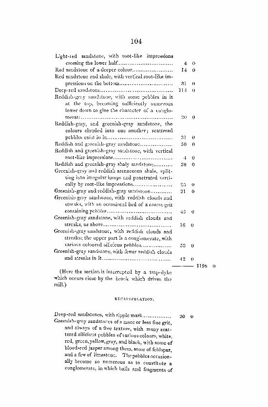
104
Light-red sandstone, with root-like impressions crossing the lower half ............................. ..
Red sandstone of a deeper colcur ...................... . Red sandstone and shale, with vertical root-like im-
pressions on the bottom ............................. . Deep-red sandstone ....................................... . Reddish-gray sandstone, with some pebbles in it
at the top, becoming sufficiently numerous lower down to give the character of a conglo-meratc .................................................. .
Reddish-gray, and greenish-gray sandstone, the colours clouded in to one another; scattered pc bbles exist iu in ................................... .
Reddish and greenish-gray sandstone ................. . Reddish and greenish-gray sandstone, with vertical
root-like impressions ................................ . Reddish and greenish-gray shaly sandstone .......... . Greenish-gray and reddish arenaceous shale, split
ting into irregular lumps and penetrated verti-cally by root-like impressions ..................... .
Greenish-gray and reddish-gray sandstone ........... . Greenish-gray sandstone, with reddish clouds and
streaks, with an occasional bed of a coarse grit containing pebbles ................................... .
Greenish-gray sandstone, with reddish clouds and streaks, as above ..................................... .
Greenish-gray sandstone, with reddish clouds and streaks; the upper part is a conglomerate, with various coloured silicious pebbles ................ .
Greenish-gray sandstone, with fewer rf'ddish clouds and streaks in it. ..................................... .
4 0 14 0
31 0 ll-Jo 0
20 0
;11 0
SO 0
4 0
38 0
~.j 0
21 0
1 -"±0 0
16 0
S3 0
42 0
---- 1198 0 (Here the section is interrupted by a trap-dyke
which occurs close by the brook whic~ drives the mill.)
RECAPITULATION.
Deep-red sandstones, with ripple mark................ 20 0 Greenish-gray sandstones of a more or less fine grit,
and always of a free texture, with many scat-tered silicious pebbles of various colours, white, red, green, yellow, gray, and black, with some of blood-red jasper among them, some of feldspar, and a few of limestone. The pebbles occasion-ally become so numerous as to constitute a conglomerate, in which balls and fragments of

10.)
clay or shale, sometimes with vegetable impres-sions on them, are often present. The shale fragments occasionally make a breccia. Ripple-mark and casts or shrillkage cracks arc met with, and beds containing vcrtical root-like illlpressions occur; or these there arc t\)'o ... "'''' .51 ~ 0
Red sandstonee; amI shales without pebbles, b~illg
at the top or a lig!]t colour, "'itll streaks of grecn, and of a deep rell at the bottom; rootlike impressions occur, and or these there arc four beels.... ........ .................................... :ll'; ()
Clouded reddish-gray and greenish-gray sandstones, witb scattered pebbles and occasional conglomerate beds. Root-like impressions occur in two beds.. .............................................. 1-1:; (I
Clouded greenish-gray and reudish-gray sallllstones, with scattered pebbles and occassional conglo-merate beus,.... ...... ... .... .................... ..... :!O:! 0
---- l[!)S II
Section on the luzcer side of tlte trap (~ljl/l', brlzc('eli the ,<"(1/1' Jfill and tlte sandy beach, tltc general (h]) (!f' (iI!' rJ/cusures beill!! {),j') < 56°,
Deep-red sandstone ................................... · Greenish-gray sandstone of a coarse grit.. ........ . Greenish-gray sandstone, with some few scattered
pebbles ................................................. . Greenish-gray sandstone, "ith more pebbles ....... . Greenish-gray sandstone, witb many pebbles ........ . Greenish-gray sandstone, with pebbles enough to
constitute a conglomerate .......................... . Greenish-gray sandstone of a coarsc grit, with peb·
bles ........................ ·························· ... . Greenish-gray sandstonc, with spots and clouds of
reddish, witb scattered pebbles and carbonised remains of plants (grasses?) in one or two places .................................................. .
(;reenish-gray sandstone, with a few scattered pcb-
blcs ......................... ·.······················ .... . Greenish-gray and reduish sandstone of a strong
quality .... , .................................. , .... ·,,····
"
.'in 0
4!1 II
1-1 0
I:! 0 f) 0
5 0
1-1 0
1-1 0
!J 0
I:! 0

106
Greenish-gray sandstone of a consistent quality, clouded and streaked with red...... ......... ...... 12 0
Greenish-gray sandstone, with more red streaks and clouds... ... ......... ............ ....... ..... ... ......... 14 0
Greenish-gray sandstone, with fewer red streaks and clouds............... ... ................................. 9 0
Greenish ·gray sandstone, with spots and clouds of reddish................................ . ................. 14 0
Greenish-gray arenaceous beds of a splintery character, not consistent enough for building, and it perhlps should be called an arenaceous shale. There are vertical root-like impressions in the top, some of them carboniseel, and there are reddish spots in the beel......... .................... 22 0
Greenish-gray sandstone. The top is of a splintery crumbly character, with roC't-like vertical impressions. There is little or no mica in the bed......... ...... ....................................... 14 0
Greenish-gray sandstone............ ... .... ......... ...... 7 0 Greenish-gray sandstone, with some fragments of
green shale............................................. J 2 0
Greenish-gray sandstone................................... 21 0
Greenish-gray sandstone, with a considerable num-ber ot scattered silicious pebbles.... ............... 24 0
Greenish.gray sandstone, with pebbles near the top, 9 0 Grcenish-gmy sandstone, with a very slight reddish
cast. The grit is coarse and there are white, red, green, and black silicious pebbles seatterI'd through the mass....................... ............. 48 0
REC .' ... rITUI~ATION.
Red sandstone..... ......... ..... .... ..... ....... ........ ... ;)0 0
Clouded greenish-gray and reddish sandstones, with sca~trrcd pebbles and occasional conglomerates; vertical root-like impressions occur in two beds .. , ................ ".... ........ ........ ...... :344 0
394 o
-~-- 394 0

107
9.
Section on the lYoTfh-II't'st siile of CIISP" Harbour, from the neighbour/lOod of the BlI~tt; across the JIICf/SII/'es Southwest/card. The dip is COlistUlit in direction, !Jllt ('({ries zn inclination, beillg 50°<::;6° to 900
•
Deep red sandstones with green patches........ ...... 29 0 Red tough crumbly arenaceous beus, with vertical
root-like impressions, and limestone nouules at the bottom. On the face of the bed ,d'e some small oval marks, with a small dot in the cen-tre. They appear to be the tcrmiuations of calcareous replacements of the vertical hbres,.. 17 0
Red arenaceous shale, with vertical root like fibres; some of the roots are rEplaced by carbonate of lime. I counted two hundred of these in a square of six inches ... '" ........................... .
Greenish-gray sandstones of a pebbly character .... . Greenish-gray sandstone, with pebbles; some of
them are fortification agate, with blood-red jas-per,and syenite with red felspar and black horn-blende, ................................................. ..
Greenish-gray sandstone; a pebbly bed at the bottom; red, white, greenish and yellow quartz, black hornstone, blood-rpd jasper, red syenite and gray limestone are among the pebbles ..... .
Greenish-gray sandstone of a conglomerate charac-ter; with the silicious pebbles are associated some of red gray and green shale ................. .
Greenish-gray and red sandstone of a crumbly yet tough quality; a bed with vertical root-like impressions exists at the top ...................... .
Green and red soft splintery sandstone, or perhaps it should be called arenaceous shale, with a band of red shale at the bottom ................. .
Greenish and red shale ................................... . Reddish and greenish, tough, splintery sandstone,
with a thin band of red shale at the bottom, having calcareous nodules and exhibiting casts of shrinkage cracks on the under-side, .......... .
Greenish and reddish tough splintery sandstone with a bed of red shale at the bottom ........... .
Greenish and reddish tough splintery sandstone, of a more shaly character than the preceding ..... .
Greenish and reddish tough splintery sandstone, with three bands of shale .......................... .
::, 0
24 0
18 0
26 0
39 0
8 0
~o 0
3 0
25 0
10 0
12 0
2 0
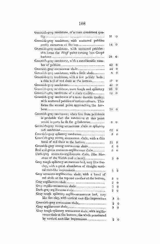
108
Greenish-gray sandstone, of a more consistent qua-lity ..................................................... .
Greenish-gray sandstone, with scattered pebbles pretty numerous at the top ....................... .
Greenish-gray sandstone, with scattered pebbles: tbis forms the Blllff point turning into Gaspe barbour ................................................ .
Greenish-gray sandstone, with a considerable nUill-ber of pebbles ........................................ .
Greenish-gray arenaceous shale ..... _ .................. . Greenish-gray sandstone, with a little shale ......... . Greenish-gray sandstone, with a few pebbly beds;
a thin bed of red shale at the bottom .......... .. Greenish-gray sandstone ................................ .. Greenish-gray sandstone, more tough and splintery Greenish-gray sandstone of a shaly quality ......... .. Greenish-gray sandstone of a more durable quality,
with scattered pebbles ofvarions colours. This forms the second point approaching the har-bour. ................................................... ..
Greenish-gray sandstone; when free from pebbles it is probable that the sandstone at this point would in parts be fit for grinds tones ............ .
Greenish-gray strong arcnaceOllS shale or splintery soft sandstone ....................................... ..
Greenish-gray splintery sandstone .................... .. Greenish-gray strong arenaceous shale, with a thin
band of red shale at the bottom ................. . Greenish-gray strong arenaceous shale ............... . Red anel green arenaceo-argillaceous shale .......... .. Dark-gray arcnaceo-argillaceous shale, (the blue-
stone of the ·Welsh coal miners) ................. .. Gray tough splintery arenaceous bcd, very like fire
clay, with a great abundance of straight verti-cal root-like impressions ............................ .
Gray arenaceo-argillaceous shale, with a band of red shale at the top and another at the bottom,
Gray argillaceous shale .................................. : Gray argillo-arenaceolls shale ......................... .. Dark-gray argillaceous shale ............................. . Gray tough splintery argillo-arenaceous bed, very
like fire-clay, with vertical root-like impressions
Greenish-gray arenaceous shale, ....................... .. Gray argillaceous shale, ................................. .. Gray tough splintery arenaceous shale, with argilla-
ceous shale at the bottom; the whole penetrated by vertical root-like impressions ................. .
31 0
14 0
28 0
43 0 14 0 8 0
47 0 45 0
26 0 13 0
70 0
8 0
r;2 0
3 0
51 0 5 0 5 0
3 0
5 0
5 0 3 0 2 0 2 0
3 0
2 0 3 0
2 0

109
Greenish-gray arenaceous shale, ........................ . Grct y argillaceous shale, ................................. .. Greenish-gray arenaceous shale ....................... .. Greenish-gray sandstone, with oblique root-like im-
pressions penetro.tinp; the bottom part , .......... . Gray tough arenaceous bed, with vertical root-like
impressions, .......................................... .. Greenish-gray arenaceous shale, with nodular sandy
concretions, ........................................... . Greenish-gray splintery sandstone, ................... .. Greenish-gray ,andstone, of a more eYen, consistent
and durable quality, ................................ . Greenish-gray splintery sandstone, .................... . C;reenish -gray sandstone, with a parting of clay be-
low, ..................................................... . Greenish-gray strong arenaceous shale, .............. . Greenish-gray sandstone, of good, useful quality,
with some few scattered pebbles, ................. .
Greenish-gray splintery sandstone, .................... . Greenish-gray hard slaty sandstone, .................. .. Greenish-gray splintery sandstone, ..................... . Greenish-gray arenaceous and argillaceous shale, .. . Greenish-gray sandstone, pebbly towards the bottom, Greenish-gray strong arenaceous shale, .............. .. Greenish-gray sandstone, .............................. .. Greenish-gray strong arenaceous shale, ............... . Greenish-gray sandstone, with some scattered
pebbles, ................................................ .
Measures not well seen, been covered by debacle, .. . Greenish-gray sandstone, with some pebbly beds .. . Measures not well seen, being cOl'ered with soil, .. .. Measures not perfectly seen, but sUPHosed to be shaly Greenish-gray sandstone, with some pebbly beds ... Measures not seen, being covered np by the herbage
and soil of a valley, ................................ .. .Measures not seen, the faee of the bank being covered
by sand, ............................................... . Measures not perfectly seen, the upper part suppo-
sed to be sandstone, ................................ .. Measures not seen, being covered up by trees and
soil in the bank and mud on the shore, ......... . Greenish-gray sandstone', ............................... .. Measures not seen, being covered up by mud and soil, Greenish-gray sandstone, ................................ . Dark-green argillo-arenaeeous shale, ................. .. Measures not seen perfectly, but supposed to be shale Greenish-gray sandstone, .............................. "
. U .J
.J 0
:l 0
.J 0
;) 0
;\ 0
~.~ 0
:3 0
2S 0
.5 0
il ()
50 0
·17 0 ~ 0
4~ 0 ,) 0
7(; 0
8 0
8 0 [j 0
l-1~ 0
46 0 sO 0
31 ()
20 ()
~Oo 0
;;4 U
~70 0
54 0
R26 0
18 0 80 0
.~o 0
13 0
53 0
10 0

110
Measures not seen, being covered up by trees and soil, 189 0
Greenish-gray sandstone, ................................ . 3 0
MeasUl es not seen, covered by soil and herbage ... . 300 0 Greenish-gray sandstone, ................................ . 27 0
lHeasLlfcs not seen, covered by soil and herbage, ... . 44 0
Greenish-gray sandstone, ................................ . 5 0
lYleasnres not seen, ........................................ . 5 0
Greenish-gray sandstone, ................................ . 22 0
Greenish-gray arenaceous shale, with vertical root-like impressions, ....................... ............... . 6 0
Greenish-gray sandstone, .... , . ... ....................... . 20-1 0
Measures not seen, being covered by soil and herbage 189 0
Greenish-gray sandstone, ................................ . 8 0
McasLlfcs not seen, being covered by soil and herbage 69 0
Greenish-gray sandstone, ................................ . 193 0
4333 0
