· 2011-09-02 · table of contents introduction ... biological assessment (ba) entitled...
TRANSCRIPT


i
TABLE OF CONTENTS Introduction................................................................................................................................... 1 CONSULTATION HISTORY ....................................................................................................... 1 BIOLOGICAL OPINION............................................................................................................ 3 DESCRIPTION OF THE PROPOSED ACTION ..................................................................... 3 Common Control Measures for Invasive Plant Species ............................................................ 5 Treatment Methods ...................................................................................................................... 6
Manual and Mechanical Invasive Plant Removal and Restoration Treatments ...................... 6 Herbicide Application Methods............................................................................................... 8
Herbicide Formulations ............................................................................................................... 9 Project Design Criteria and Herbicide Application Buffers................................................... 11 Project Monitoring ..................................................................................................................... 20 STATUS OF THE SPECIES – Bull Trout ............................................................................... 22 ENVIRONMENTAL BASELINE ............................................................................................. 31 EFFECTS OF THE PROPOSED ACTION............................................................................. 37 Effects of Non-herbicide Treatment Methods.......................................................................... 42 General Effects of Herbicide Use for Invasive Plant Treatments .......................................... 44
Herbicide Risk Assessments.................................................................................................. 45 Chronic and Acute Herbicide Exposures ................................................................................. 48
Low Risk Herbicides: Clopyralid, Imazapic, and Metsulfuron methyl................................. 50 Moderate Risk Herbicides: Chlorsulfuron, Imazapyr, and Sulfometuron methyl................. 51 Higher Risk Herbicides: Glyphosate, triclopyr, picloram, and sethoxydim.......................... 51
Effects of the Proposed Action to Bull Trout ........................................................................... 60 Proximity of Bull Trout Habitat to Treatment Areas............................................................. 60 Effects of Riparian Applications ........................................................................................... 62 Effects of Emergent Vegetation Treatments.......................................................................... 63 Effects of Treatment of Dry Intermittent Channels and Ditches........................................... 66 Unknown Future Invasive Plant Treatments ......................................................................... 68 Summary of Proposed Treatments in Bull Trout Spawning Watersheds .............................. 69 Effects to Individuals ............................................................................................................. 71 Effects to Local Populations and Core Areas ........................................................................ 73
CUMULATIVE EFFECTS........................................................................................................ 75 CONCLUSION ........................................................................................................................... 76 INCIDENTAL TAKE STATEMENT ...................................................................................... 77
Amount or Extent of Take ..................................................................................................... 77 Effect of the Take ......................................................................................................................... 79
Reasonable and Prudent Measures ........................................................................................ 79 Terms and Conditions............................................................................................................ 79 Conservation Recommendations ........................................................................................... 81 Reinitiation Notice................................................................................................................. 82
LITERATURE CITED .............................................................................................................. 83 APPENDIX A – Common Control Measures for Invasive Plants Species ............................ 91

1
Introduction This document presents the U.S. Fish and Wildlife Service’s (FWS) Biological Opinion (BO), based on our review of the U.S. Forest Service (FS) proposed invasive plant treatment program and its effects on threatened bull trout (Salvelinus confluentus) within the Gifford Pinchot National Forest (GPNF) and the Columbia River Gorge National Scenic Area (CRGNSA) in Washington. This document has been prepared in accordance with section 7 of the Endangered Species Act of 1973, as amended (16 U.S.C. 1531 et. seq.) (Act). This document is based on information provided in the January 19, 2007, Biological Assessment (BA) entitled Biological Assessment for the USDA Forest Service Gifford Pinchot National Forest (GPNF) and Columbia River Gorge National Scenic Area Invasive Plant Treatment Project (U.S. Forest Service 2007) and in numerous meetings and other communications between our respective staffs. Copies of all correspondence regarding this consultation are on file in the FWS’s Western Washington Fish and Wildlife Office in Lacey, Washington. The invasive plant treatment BA was developed by an interagency consultation team (referred to as the Level 1 Team) including staff from the FS, National Oceanic and Atmospheric Administration National Marine Fisheries Service (NMFS), and the Western Washington Fish and Wildlife Office. The Level 1 Team worked together periodically over the past 2 years to review and develop project design criteria that incorporate the best management practices to minimize adverse effects to aquatic resources. The BA describes and evaluates the effects of manual, mechanical and chemical invasive plant treatment methods. CONSULTATION HISTORY Pacific Northwest Region Invasive Plants Program Invasive species were identified by the Chief of the FS as one of the four threats to forest health. Invasive plants are displacing native plants, reducing the quality of fish and wildlife habitat, and degrading natural areas throughout the Pacific Northwest. In 2005, the FS completed the Final Environmental Impact Statement (FEIS) and Record of Decision (ROD) for the Pacific Northwest Region Invasive Plant Program (U.S. Forest Service 2005). The Invasive Plant Program FEIS/ROD amended individual forest management plans in Oregon and Washington and provides direction for the prevention and treatment of invasive plants, and associated restoration activities. Several broad Federal policies require the control of invasive plants. Executive Order 13112 (1999) directs Federal agencies to reduce the spread of invasive plants. The FS Pesticide Use Handbook (FSH 2109.14) provides agency guidance on planning, implementation, and reporting of projects that include herbicide use. The Invasive Plants Program FEIS/ROD allows the use of 10 herbicides for invasive plant management and control. The FEIS and formal consultation on the Invasive Plant Program covers the plan-level requirements, but did not address site-specific information. The FS agreed to complete National Environmental Policy Act (NEPA) and section 7 compliance at a more site-specific level prior to the implementation of any projects that may affect listed species. The FWS issued a BO for the Pacific Northwest Region Invasive Plant Program on September 7,

2
2005. The ROD implementing the FEIS was released on November 9, 2005 (R6 2005 ROD). Much of the information contained in the FEIS, Biological Assessment, and BOs for the Pacific Northwest Region Invasive Plant Program has been incorporated into the site specific analysis completed for the GPNF/CRGNSA Invasive Plant Treatment Program. GPNF/CRGNSA Invasive Plant Treatment Program Informal consultation between the FS and the FWS for the GPNF/CRGNSA invasive plant program was initiated in August 2005. In August, 2006, the FS released a Draft Environmental Impact Statement (DEIS) for Gifford Pinchot National Forest and Columbia River Gorge National Scenic Area (Washington portion) Site Specific Invasive Plant Treatments (U.S. Forest Service 2006). Over the course of 2006 and into early 2007, there have been a series of meetings and negotiations between the FS, FWS, and NMFS staff to develop the project description and finalize the Biological Assessment. In a letter dated January 17, 2007, the FS submitted their final BA requesting both formal and informal consultation. The BA addresses effects to the following federally listed species: Threatened Species: Bull trout (Salvelinus confluentus) Bald eagle (Haliaeetus leucocephalus) Marbled murrelet (Brachyramphus marmoratus) Northern spotted owl (Strix occidentalis caurina) In the BA, the FS determined the proposed action “may affect, and is likely to adversely affect” bull trout. The BA also concluded that the proposed action “may affect, but is not likely to adversely affect” the bald eagle, northern spotted owl, and marbled murrelet. The BA also addresses federally listed Pacific salmon species under the jurisdiction of NMFS. Effects to these species are addressed in a separate consultation document to be completed by NMFS. In a letter dated October 9, 2007, the FWS concurred with the FS effect determinations for northern spotted owl and marbled murrelet (FWS reference number 13410-2007-I-0647). Those species will not be addressed in this document. Copies of all correspondence between the FS, FWS, and NMFS are located in the project record.

3
BIOLOGICAL OPINION DESCRIPTION OF THE PROPOSED ACTION The following is a summary of the description of the action in the BA for the GPNF/CRGNSA Invasive Plant Program. The complete BA is included in this document by reference (U.S. Forest Service 2007). Invasive plants are defined as alien plant species whose introduction does, or is likely to, cause economic or environmental harm or harm to human health. It does not include native species. The purpose of this project is to control invasive plants in a cost-effective manner that complies with environmental standards. Proposed treatment methods include herbicide application mainly along roadsides and other previously disturbed areas in combination with manual and mechanical treatments. With this project, the FS is responding to the need for timely containment, control, and/or eradication of invasive plants, including those that are currently known and those discovered in the future. Approximately 30,000 acres of National Forest system lands were aggregated into treatment areas. The treatment areas incorporate known and suspected vectors for invasive plant spread. About 2,710 acres within the treatment areas are proposed for treatment. This estimate incorporates predicted rates of spread of known invasive plants within treatment areas. The following description of the proposed action focuses on elements of the proposal important to the analysis in this BO. A detailed description including additional elements of the action (that are not relevant to the analysis in this BO) is in the DEIS (U.S. Forest Service 2006). The proposed action (Alternative B in the DEIS) was developed to respond to the need for action by approving herbicide and non-herbicide treatments to eradicate, contain, and/or control the spread of invasive plants. The proposed action would approve treatments based on common control measures. Treatment areas are geographic assemblages of inventoried and anecdotal invasive plant sites based on current infestations and predicted vectors or spread. About 111 treatment areas are mapped on the GPNF/CRGNSA, covering about 30,000 gross acres. The majority of the infestations are along roadsides and other disturbed areas. Tables 1 and 2 below summarize infested acres by treatment area description. Appendix A of the DEIS provides data tables corresponding to maps depicting the treatment areas.

4
Table 1. Infested acres by treatment area description, CRGNSA, Washington side.
Treatment Area Description Total Acres All Treatment Options Available, Including Herbicide
Proportion of Estimated Herbicide Acres that May be Broadcast Sprayed
Clearings, Fields and Grasslands 180 25% or approx. 45 acres (Mount
Pleasant area)
Recreation Areas 162 31% or approx. 50 acres
(Balfour Day Use Site)
Forested Areas 13 0% - no broadcasting is proposed for the Collins Slide forested site
Wetlands 5 0% - no broadcasting would be proposed in wetlands
Total Acres 360 26% or approx. 95 acres
Table 2. Infested acres by treatment area description, GPNF.
Treatment Area Description Total Acres All Treatment Options Available, Including Herbicide
Proportion of Estimated Herbicide Acres that May be Broadcast
Roadside 2,000 37% or approx. 740 acres
Quarries 29 34% or approx. 10 acres
Meadow 104 0% - no broadcasting would be proposed in meadows
Administrative Sites 12 33% or approx. 4 acres of developed areas
Campgrounds and Camping Areas 102 39% or approx. 40 acres
Viewpoints and Parking Areas 52 No broadcasting is currently proposed in these areas.
Roads and Landings in Managed Timber Stand 51 39% or approx. 20 acres
Total Acres 2,350 35% or approx. 814 acres

5
The proposed action also comprises a programmatic approach for treatment of future infestations, referred to as “early detection, rapid response” (EDRR). The GPNF/CRGNSA proposes to allow for treatment “within the scope of the EIS” to occur on new, unknown, and unpredicted infestations found over the next five years. This element of the proposed action is programmatic in nature. Under the EDRR approach, new or previously undiscovered infestations would be treated using the range of methods described below. The EDRR approach is needed because 1) the precise location of individual target plants, including those mapped in the current inventory (2004 Data Base), is subject to rapid and/or unpredictable change, and 2) as the typical Environmental Impact Statement process would not allow for rapid response, infestations may grow and spread into new areas during the time it usually takes to prepare required documentation. The intent of the EDRR approach is to treat new infestations when they are small so that the likelihood of adverse treatment effects is minimized. The approach is based on the premise that the impacts of similar treatments are predictable, even though the precise location or timing of the treatment may be unpredictable. The proposed action provides spatial limitations for the implementation of EDRR on an annual basis. Project Design Criteria (PDCs) in Table 4 below identifies those limitations (H14). For invasive plant sites above the bankfull channel width, within the aquatic influence zone, treatments would not exceed 10 acres along any 1.5 mile of stream reach within a 6th field subwatershed in any given year. In addition, for invasive plant sites below bankfull, treatments would not exceed a total of 7 acres within a 6th field sub-watershed in any given year. The implementation planning process detailed below is intended to ensure that treatment approaches are within the scope of those analyzed in this BO. New situations that may have different treatment needs would be subject to further section 7 consultation. Initially, a tiered, two-step process was developed by the Level 1 Team to facilitate section 7 compliance for projects implemented under the EDRR “programmatic” element of the proposed action. However, since this BO is authorizing incidental take, the tiered process is not necessary, and will not be employed. Common Control Measures for Invasive Plant Species The GPNF/CRGNSA has identified numerous invasive species within the treatment areas. Common names, scientific names, and common control measures for invasive species are summarized in Appendix A. The common control measures are the starting point for site-specific prescriptions, which would be refined for specific sites according to PDCs. Some control measures listed in Appendix A may not be available in some locations due to the PDCs (for instance, broadcast treatment of any herbicide within 100 ft of a live stream). The common control measures would be applied to site-specific conditions as part of the implementation planning process. Many of the target species may grow in riparian areas. A few, such as knotweed, reed canarygrass, purple loosestrife, and the thistles tend to be associated with meadows, wetlands, and streams.

6
Treatment Methods The proposed action employs a variety of invasive plant treatment methods (manual, mechanical, and herbicide treatments, and restoration methods). The following is a brief description of the different treatment methods proposed. Cultural Methods
Grazing with Goats Grazing animals are limited to goats in this proposal. Goat grazing would not in itself eradicate invasive plants. However, when grazing treatments are combined with other control techniques, such as herbicides, large infestations would be reduced in size and small infestations could be eliminated. Grazing animals may be particularly useful in areas where herbicides cannot be applied (e.g., near water) or are prohibitively expensive (e.g., large infestations). Goats would be used as part of a restoration program by breaking up the soil and incorporating in seeds of desirable native plants. They prefer broadleaf herbs and have been used to control leafy spurge (Euphorbia esula), Russian knapweed (Acroptilon repens), and toadflax (Linaria spp.). These animals appear to be able to neutralize the phytochemicals toxic to other animals that are present in these and other forbs (Walker 1994, as cited in U.S. Forest Service 2006). Goats can control woody species because they can climb and stand on their hind legs, and will browse on vegetation other animals cannot reach. Grazing is proposed for managing weeds only at the St. Cloud/Sam Walker site in the CRGNSA. Manual and Mechanical Invasive Plant Removal and Restoration Treatments Manual techniques in the proposed action include hand pulling, clipping, or digging out invasive plants with non-motorized hand tools. Mechanical methods involve chain saws, mowers, or other mechanized equipment, such as brush cutters, or other machinery with various types of blades to remove plants. Manual methods include the use of hand-operated tools (e.g., axes, brush hooks, hoes, shovels, hand clippers) to dig up and remove noxious species. These techniques tend to minimize damage to desirable plants and animals, but they are generally labor and time intensive. Treatments must typically be administered several times a year over several years to prevent the weed from re-establishing. Manual and mechanical techniques are generally favored to treat small infestations and/or in situations where a large pool of volunteer labor is available. They are often used in combination with other techniques.
Weed Pulling Pulling or uprooting plants can be effective against some shrubs, tree saplings, and herbaceous weeds. Annuals and tap-rooted plants are particularly susceptible to control by hand-pulling. Weed wrenches and other tools are surprisingly powerful and can enable a person to control large saplings and shrubs that are too big to be pulled by hand. Weed pulling is not as effective against many perennial weeds with deep underground stems and roots that are often left behind to re-sprout. Weed pulling may be a good alternative in sites where herbicides or other methods cannot be used.

7
Clip and Pull Methods “Clip” means to cut or remove seed heads and/or fruiting bodies to prevent germination. “Clip and pull” means cutting a portion of the invasive plant stem and pulling it from its substrate, generally the bole of a tree. This method is labor intensive, but can be effective for larger infestations.
Mowing, Cutting, Brush Hog, Raking, Trimming Mowing and cutting can reduce seed production and restrict weed growth, especially in annuals cut before they flower and set seed. Some species however, re-sprout vigorously when cut, replacing one or a few stems with many that can quickly flower and set seed. These treatments are used as primary treatments to remove aboveground biomass in combination with herbicide treatments to prevent resprouting, or as follow up treatments to treat target plants missed by initial herbicide use.
Stabbing Some plants can be killed by severing or injuring (stabbing) the carbohydrate storage structure at the base of the plant. Depending on the species, this structure may be a root corm, storage rhizome (tuber), or taproot. These organs are generally located at the base of the stem and under the soil. Cutting off access to these storage structures can help “starve” or greatly weaken some species.
Girdling Girdling is often used to control trees or shrubs that have a single trunk. It involves cutting away a strip of bark several cm wide all the way around the trunk. The removed strip must be cut deep enough into the trunk to remove the vascular cambium, or inner bark, the thin layer of living tissue that moves sugars and other carbohydrates between areas of production (leaves), storage (roots), and growing points. This inner cambium layer also produces all new wood and bark.
Site Restoration Treatment site restoration may include hand or machine mulching (machines limited to areas that are on roads), seeding, and/or planting with hand tools, or may be passive in situations where desirable vegetation can naturally replace target invasive species removed. Restoration prescriptions will be developed by appropriate GPNF/CRGNSA staff during implementation planning and will be influenced by site-scale conditions and broader land management objectives (for more information on restoration prescription process, see Appendix F of the GPNF/CRGNSA DEIS). The GPNF/CRGNSA predicts that passive restoration will be successful on about 35 percent of the treatment sites, with 65 percent needing some kind of mulching, seeding, and/or infrequent planting. This proportion is based on the range of situations surrounding the inventoried invasive plant populations known across the GPNF/CRGNSA. For instance, meadows and forested areas are most likely to respond favorably to passive restoration, while roadsides and other highly disturbed areas may require mulching and/or seeding/planting with desirable vegetation. The intent is to re-establish competitive local, native vegetation post-treatment in areas of bare ground. In some cases, preferred non-natives may be utilized as temporary ground cover for erosion control and as noxious weed competitors, until native species can become

8
established at the site. Preferred non-natives would not aggressively compete with natives, persist long-term, or exchange genetic material with local native plant species. Evaluation for site restoration may occur before, during and after herbicide, manual and mechanical treatments. Passive site restoration would be favored in areas having a stable, diverse, native plant community and sufficient organics in the soil to sustain natural revegetation. If the soils lack sufficient organics, mulch and/or mycorrhizae would be added. Herbicide Application Methods There are three types of herbicide application methods considered under the proposed action:
Broadcast Spraying Broadcast spray methods distribute herbicide over broad areas covering both target plants and non-target plants. Broadcast treatments would typically be used to treat denser patches of target vegetation (where target vegetation covers approximately 70 percent of the area or more). Broadcast methods include booms; boom-less nozzles, and backpack sprayers if not directed at individual plants. A boom, a long horizontal tube with multiple spray heads, may be mounted or attached to a tractor, ATV or other vehicle. The boom is then carried above the weeds while spraying herbicide, allowing large areas to be treated rapidly with each sweep of the boom. Offsite movement of herbicide due to vaporization or drift and possible treatment of non-target plants can be of concern when using this method.
Spot Spray Herbicide is sprayed directly onto small patches or individual target plants. Non-target plants are avoided. These applicators range from motorized rigs with spray hoses to backpack sprayers, to hand-pumped spray or squirt bottles, all of which can target very small plants or parts of plants. Applications are typically hand-directed. Drift is far less of a concern because the applicator ensures that spray is directed immediately toward the target plant given the technical advancement in machinery and equipment.
Hand/Selective Applications Hand/selective herbicide application methods treat individual target plants, reducing the potential for herbicide to impact soil or non-target organisms. Hand/selective methods include wicking and wiping; basal bark treatment; frill, hack and squirt, stem injection, and/or cut-stump methods.
Wicking/Wiping Wicking or wiping methods involve using a sponge, spray bottle, paint brush, cloth and/or a wick on a long handle to wipe or apply herbicide onto individual foliage and/or stems. Use of a wick or other tools mentioned above eliminates the possibility of spray drift and minimizes potential for droplets falling on non-target plants.

9
Basal Bark Treatment This method applies a 6 to 12 inch band of herbicide around the circumference of the trunk of the target plant, approximately one foot above ground. The width of the sprayed band depends on the size of the plant and the species’ susceptibility to the herbicide.
Frill, Hack and Squirt The frill and the “hack and squirt” methods are often used to treat woody species with large, thick trunks. The tree is cut using a sharp knife, saw, or ax, or drilled with a power drill or other device. Herbicide is then immediately applied to the cut with a backpack sprayer, squirt bottle, syringe, or similar equipment.
Stem Injection Herbicides can be injected into herbaceous stems using a needle and syringe. Herbicide pellets can also be injected into the trunk of a tree using a specialized tool. In some instances, maximum label application rates are needed for effective stem injection treatments.
Cut-stump Application This method is often used on woody species that normally re-sprout after being cut. The tree or shrub is cut down, and herbicide is immediately sprayed or squirted on the exposed cambium (living inner bark) of the stump. The herbicide must be applied to the entire inner bark (cambium) within minutes after the trunk is cut. The cut stump treatment allows for a great deal of control over the site of herbicide application, and therefore, has a low probability of affecting non-target species or contaminating the environment. It also requires only a small amount of herbicide to be effective. The following treatment methods are not included in the proposed action:
• Aerial herbicide applications.
• Herbicides other than the ten analyzed in this document.
• Prescribed burning.
• Plowing/tilling/disking/digging with heavy equipment.
• Flooding/drowning.
• Foaming and steaming.
Herbicide Formulations Herbicides are sold as one or more commercial products, called formulations (e.g., Roundup; Garlon 3A). An herbicide formulation includes one or more compounds (e.g., glyphosate) that are the active ingredients, as well as other ingredients such as surfactants and additives. The product label for an herbicide formulation provides legally binding direction on its use, including safe handling practices, application rates, and practices to protect human health and the environment. Under the proposed action, the GPNF/CRGNSA is limited to applications within the limits of product label directions.

10
The proposed action includes the use of ten herbicides. The highest application rate in riparian areas on National Forest lands would only be allowed when hand/select application methods are used (Table 3). In no case would actual applications exceed rates listed on herbicide labels. Herbicide applications would primarily occur on terrestrial invasive weeds growing along banks of streams, in ditches and upland. However, treatment of invasive weeds growing above the water’s surface in small lakes, ponds, streams and/or wet areas (emergent target vegetation) is also proposed. Such treatments are limited in extent (no more than 6 acres per year per 6th field watershed). Table 3. List of herbicides and application rates considered under the proposed action.
Herbicide (active ingredient)
Typical Application Rate
lb ai/ac*
Highest Application Rate lb ai/ac
Chlorsulfuron 0.056 0.25 Clopyralid 0.35 0.5 Glyphosate 2 7 Imazapic 0.13 0.19 Imazapyr 0.45 1.25 Metsulfuron Methyl 0.03 0.15 Picloram 0.35 1.0 Sethoxydim 0.3 0.38 Sulfometuron Methyl 0.045 0.38 Triclopyr 1.0 10 NPE 1.67 6.68 Hexachlorobenzene# 0.000004 0.000012 * pounds of active ingredient (ai) per acre #These application rates reflect the incidental rates of application of the impurity hexachlorobenzene, found primarily in picloram, and to a lesser extent in clopyralid. The proposed action allows for the use of mixtures of herbicide formulations containing no more than 3 of the active ingredients. Because adjuvants and inert ingredients included in herbicide formulations may also cause effects to non-target species, the program limits their use to those reviewed in FS hazard and risk assessment documents such as Syracuse Environmental Research Associates Inc. (SERA) (2003). Surfactants and Additives Herbicide manufacturers add inert ingredients (or other ingredients) to enhance the action of the active ingredient. Inert ingredients may include carriers, surfactants, spray adjuvants, preservatives, dyes, and anti-foaming agents among other chemicals. Because many manufacturers consider inerts in their herbicide formulations to be proprietary, they do not list specific chemicals. Several types of surfactants or additives are proposed for use and have been reviewed in risk assessments or reviews and thus meet the GPNF/CRGNSA Land and Resource Management Plans, as amended by the R6 2005 ROD. These additives are used to help herbicides adhere to target plants and reduce drift. For the proposed action, only those additives
Comment [RD1]: Is this sentence necessary? I suggest omitting it since label rates are addressed in the same paragraph a few sentences later and something different is stated.

11
that are approved by the Washington State Department of Agriculture (WSDA) and Department of Ecology and comply with the amended GPNF/CRGNSA Land and Resource Management Plans will be permitted for use within riparian areas. Adjuvants are solution additives that are mixed with an herbicide solution to improve performance of the spray mixture. They can either enhance activity of an herbicide’s active ingredient or offset any problems associated with spray application. Adjuvants include surfactants, anti-foaming agents, crop oil or crop oil concentrates, drift retardants, compatibility agents, and pH buffers. Carriers are used to dilute or suspend herbicides during application and allow for proper placement of the herbicide, whether to soil or on foliage. Surfactants that are primarily oil-based have been gaining in popularity especially for the control of grassy weeds. Oil additives function to increase herbicide absorption through plant tissues and increase spray retention. They are especially useful in applications of herbicides to woody brush or tree stems to allow for penetration through the bark. Oil adjuvants are made up of either petroleum, vegetable, or methylated vegetable or seed oils plus an emulsifier for dispersion in water. For a list of approved products, refer to page 27 in the BA, and refer to Appendix C in the BA for a list of formulations considered in the FS risk assessments. Project Design Criteria and Herbicide Application Buffers The GPNF/CRGNSA will use the following project design criteria (PDCs) and buffers as conservation measures to minimize or eliminate the potential impacts of invasive plant treatment (as per R6 2005 ROD Standards 19 and 20 (and other Forest Plan management direction), and provide sideboards for treatment of existing inventories and EDRR sites. Implementation of the PDCs and buffers are mandatory to ensure that treatments would have effects within the scope of those disclosed in the BA. The PDCs were developed to address a range of site-specific resource conditions within treatment areas, including (but not limited to): the presence of species of local interest and their habitats, potential for herbicide delivery to water, and the social environment. The following PDCs are a subset of the proposed project. For a complete list please refer to Table 8 of the BA. The following list (Table 4) includes only those PDCs specific to avoiding or minimizing potential effects of the proposed action on federally listed and proposed fish and their habitat, and pertinent for the analysis in the BO. The PDCs add layers of caution to herbicide label requirements and Forest Plan standards by limiting the rate and method of herbicide application, by buffering streams from varying herbicide application methods and restricting certain higher-risk herbicides near streams. The GPNF/CRGNSA asserts that this conservative approach was taken to limit the potential amount of herbicides coming in contact with water at concentrations of concern, while allowing for a range of effective treatments for known and predicted situations. Under the Proposed Action, buffers along streams, lakes, ponds, and wetlands in Tables 5, 6, and 7 would be required.

12
Table 4. Project Design Criteria (PDCs) for the GPNF/CRGNSA invasive plant treatment program.
PDC Reference Design Criteria Purpose of PDC Source of PDC
A Pre-Project Planning
A1 Prior to treatment, confirm species/habitats of local interest, watershed and aquatic resources of concern (e.g. hydric soils, streams, lakes, roadside treatment areas with higher potential to deliver herbicide, municipal watersheds, domestic water sources), places where people gather, and range allotment conditions.
Ensure project is implemented appropriately.
This approach follows several previous NEPA documents. Pre-project planning also discussed in the previous section.
B Coordination with Other Landowners/Agencies
B1 Work with owners and managers of neighboring lands to respond to invasive plants that straddle multiple ownerships. Coordinate treatments within 150 ft of Forest boundaries, including lands over which the Forest has right-of-way easements, with adjacent landowners.
To ensure that neighbors are fully informed about nearby herbicide use and to increase the effectiveness of treatments on multiple ownerships.
The distance of 150 ft was selected because it approximates the Aquatic Influence Zone for fish bearing streams.
B2 Coordinate herbicide use within 1000 ft (slope distance) of known water intakes with the water user or manager.
To ensure that neighbors are fully informed about nearby herbicide use.
The distance of 1000 ft was selected to respond to public concern. Herbicide use as proposed for this project would not contaminate drinking water supplies.
B3 Coordinate herbicide use with Municipal Water boards. Herbicide use or application method may be excluded or limited in some areas.
To ensure that neighbors are fully informed about nearby herbicide use and standards for municipal watersheds are met.
1990 Gifford Pinchot National Forest and existing municipal agreements.
C To Prevent the Spread of Invasive Plants During Treatment Activities
C1 Ensure vehicles and equipment (including personal protective clothing) do not transport invasive plant materials.
To prevent the spread of invasive plants during treatment activities
Common measure.
D Wilderness Areas 1
D1 No cultural, mechanical or motorized treatments would occur in Wilderness areas.
To maintain Wilderness character and meet environmental standards.
Wilderness Act, 1990 Gifford Pinchot National Forest Plan
D2 Choose minimum impact treatment methods. To maintain Wilderness values (e.g. solitude, unimpeded natural processes) and comply with environmental laws and policies.
Wilderness Act, 1990 Gifford Pinchot National Forest Plan
E There are no Design Features under “E”.
F Herbicide Applications
1 Invasive plant eradication within Wilderness areas meets the “no impact” intent of the Wilderness Act and associated land use policies.

13
PDC Reference Design Criteria Purpose of PDC Source of PDC
F1 Herbicides would be used in accordance with label instructions, except where more restrictive measures are required as described below. Herbicide applications would only treat the minimum area necessary to meet site objectives. Herbicide formulations would be limited to those containing one or more of the following 10 active ingredients: chlorsulfuron, clopyralid, glyphosate, imazapic, imazapyr, metsulfuron methyl, picloram, sethoxydim, sulfometuron methyl, and triclopyr. Herbicide application methods include wicking, wiping, injection, spot, and broadcast, as permitted by the product label and these Project Design Criteria. The use of triclopyr is limited to spot and hand/selective methods. Herbicide carriers (solvents) are limited to water and/or specifically labeled vegetable oil.
To limit potential adverse effects on people and the environment.
Standard 16, 2005 R6 ROD; Pesticide Use Handbook 2109.14
F2 Herbicide use would comply with standards in the Pacific Northwest Regional Invasive Plant Program – Preventing and Managing Invasive Plants FEIS (2005), including standards on herbicide selection, restrictions on broadcast use of some herbicides, tank mixing, licensed applicators, and use of adjuvants, surfactants and other additives. See Appendix B for tank mixture analysis.
To limit potential adverse effects on people and the environment.
2005 R6 ROD Treatment Standards (see Chapter 1).
F3 POEA surfactants, urea ammonium nitrate or ammonium sulfate would not be used in applications within 150 ft of surface water, wetlands or on roadside treatment areas having high potential to deliver herbicide.
To protect aquatic organisms.
The distance of 150 ft was selected because it is wider than the largest buffer and approximates the Aquatic Influence Zone for fish bearing streams.
F4 Lowest effective label rates would be used for each given situation. In no case would broadcast applications of herbicide or surfactant exceed typical label rates. NPE would never be broadcast at a rate exceeding 0.5 active ingredient per acre, and other classes of surfactants besides NPE would be favored wherever they are expected to be effective. In no case would imazapyr exceed 0.70 lbs.
To eliminate possible herbicide or surfactant exposures of concern to human health, wildlife, and/or fish.
SERA Risks Assessments, Appendix Q of the R6 2005 FEIS
F5 Herbicide applications would occur when wind velocity is between two and eight miles per hour. During application, weather conditions would be monitored periodically by trained personnel.
To ensure proper application of herbicide and reduce drift.
These restrictions are typical so that herbicide use is avoided during inversions or windy conditions.
F6 To minimize herbicide application drift during broadcast operations, use low nozzle pressure; apply as a coarse spray, and use nozzles designed for herbicide application that do not produce a fine droplet spray, e.g., nozzle diameter to produce a median droplet diameter of 500-800 microns.
To ensure proper application of herbicide and reduce drift.
These are typical measures to reduce drift. The minimum droplet size of 500 microns was selected because this size is modeled to eliminate adverse effects to non-target vegetation 100 ft or further from broadcast sites (see Chapter 3.2 of GPNF/CRGNSA DEIS for details).

14
PDC Reference Design Criteria Purpose of PDC Source of PDC
G Herbicide Transportation and Handling Safety/Spill Prevention and Containment An Herbicide Transportation and Handling Safety/Spill Response Plan would be the responsibility of the herbicide applicator. At a minimum the plan would:
Address spill prevention and containment. Estimate and limit the daily quantity of herbicides to be
transported to treatment sites. Require that impervious material be placed beneath
mixing areas in such a manner as to contain small spills associated with mixing/refilling.
Require a spill cleanup kit be readily available for herbicide transportation, storage and application (minimum FOSS Spill Tote Universal or equivalent).
Outline reporting procedures, including reporting spills to the appropriate regulatory agency.
Ensure applicators are trained in safe handling and transportation procedures and spill cleanup.
Require that equipment used in herbicide storage, transportation and handling are maintained in a leak proof condition.
Address transportation routes so that traffic, domestic water sources, and blind curves are avoided to the extent possible.
Specify conditions under which guide vehicles would be required.
Specify mixing and loading locations away from water bodies so that accidental spills do not contaminate surface waters.
Require that spray tanks be mixed or washed further than 150 ft of surface water.
Ensure safe disposal of herbicide containers. Identify sites that may only be reached by water travel
and limit the amount of herbicide that may be transported by watercraft.
To reduce likelihood of spills and contain any spills.
FSH 2109.14, Bonneville Power Administration Biological Assessment, Buckhead Knotweed Project, Willamette NF Biological Assessment
H Soils, Water and Aquatic Ecosystems H1 Herbicide use buffers have been established
for perennial and wet intermittent steams; dry streams; and lakes and wetlands. These buffers are depicted in the tables below. Buffers vary by herbicide ingredient and application method. Tank mixtures would apply the largest buffer as indicated for any of the herbicides in the mixture.
To reduce likelihood that herbicides would enter surface waters in concentrations of concern. Comply with R6 2005 ROD Standards 19 and 20.
Buffers are based on label advisories, and SERA risk assessments. Buffer distances are based on the Berg’s 2004 study of broadcast drift and run off to streams, along with Washington State Dept. of Agriculture’s 2003-2005 monitoring results.

15
PDC Reference Design Criteria Purpose of PDC Source of PDC
H2 The following treatment methods are shown in order of preference (if effective and practical), within roadside treatment areas having high risk of herbicide delivery and aquatic influence areas, especially adjacent to fish bearing streams: (1) Manual methods (e.g., hand pulling). (2) Application of clopyralid, imazapic, and metsulfuron methyl, aquatic glyphosate, aquatic triclopyr, aquatic imazapyr. (3) Application of chlorsulfuron, imazapyr, sulfometuron methyl. (4) Application of glyphosate, triclopyr, picloram, and sethoxydim (see H3, picloram on non-aquatic triclopyr would not be used on roadside treatment areas that have a high risk of herbicide delivery).
To protect aquatic organisms by favoring lower risk methods where effective.
Herbicides were classed into low, moderate and higher risk to aquatic organisms based on SERA Risk Assessments. Lower risk herbicides are preferred where effective. Non-herbicide, manual methods have the least potential for impact, therefore they would be preferred.
H3 No use of picloram or triclopyr BEE and no broadcast of any herbicide on roadside treatment areas that have a high risk of herbicide delivery to surface waters (see Appendix A for map and list of these roads).
To ensure herbicide is not delivered to streams in concentrations that exceed levels of concern.
SERA Risk Assessments, R6 2005 FEIS Fisheries Biological Assessment Extra caution is warranted on the Gifford Pinchot National Forest and Columbia River Gorge National Scenic Area (Washington side) because of the many aquatic Species of Local Interest in Forest streams.
H4 Aquatic labeled herbicides or herbicides associated with lower risk to aquatic organisms would be applied using spot or hand/selective methods within 15 ft of the edge of a wet roadside ditch. For treatments of target vegetation emerging out of the wet roadside ditch only aquatic labeled herbicides would be used.
To ensure herbicide is not delivered to streams in concentrations that exceed levels of concern.
SERA Risk Assessments R6 2005 FEIS and Fisheries Biological Assessment BPA Columbia River BO. Extra caution is warranted on the Gifford Pinchot National Forest and Columbia River Gorge National Scenic Area (Washington side) because of the many aquatic species of local interest in Forest streams.
H5 Vehicles (including all terrain vehicles) used to access or implement invasive plant projects, would remain on roadways, trails, parking areas or other previously disturbed areas to prevent damage to riparian vegetation and soil, and potential degradation of water quality and aquatic habitat.
To protect riparian and aquatic habitats.
BPA Columbia River BO.
H6 Avoid use of clopyralid on high-porosity soils (coarser than loamy sand).
To avoid leaching/ground water contamination.
Label advisory.
H7 Avoid use of chlorsulfuron on soils with high clay content (finer than loam).
To avoid excessive herbicide runoff.
Label advisory.

16
PDC Reference Design Criteria Purpose of PDC Source of PDC
H8 Avoid use of picloram on shallow or coarse soils (coarser than loam.) No more than one application of picloram would be made within a two-year period, except to treat areas missed during initial application.
To reduce the potential for picloram to enter surface and/or ground water and/or accumulate in the soil. Picloram has the highest potential to impact organisms in soil and water, and tends to be more persistent than the other herbicides.
SERA Risk Assessment. Based on quantitative estimate of risk from worst-case scenario and uncertainty
H9 Avoid use of sulfometuron methyl on shallow or coarse soils (coarser than loam.) No more than one application of sulfometuron methyl would be made within a one-year period, except to treat areas missed during initial application.
To reduce the potential for sulfometuron methyl accumulation in the soil. Sulfometuron methyl has some potential to impact soil and water organisms and is second most persistent.
SERA Risk Assessments. Based on quantitative estimate of risk from worst-case scenario and uncertainty.
H10 Lakes and Ponds – No more than half the perimeter or 50 percent of the vegetative cover or 10 contiguous acres around a lake or pond would be treated with herbicides in any 30-day period.
To reduce exposure to herbicides by providing some untreated areas for some organisms to use.
SERA Risk Assessments. Based on quantitative estimate of risk from worst-case scenario and uncertainty regarding effects to reptiles and amphibians.
H11 Wetland vegetation would be treated when soils are driest. If herbicide treatment is necessary for emergent target plants when soils are wet, use aquatic labeled herbicides. Favor hand/selective treatment methods where effective and practical.
To reduce exposure to herbicides by providing some untreated areas for some organisms to use.
SERA Risk Assessments. Reduces exposure to herbicides by providing untreated areas for organisms to use. Abates risks associated with worst-case models for treatment of emergent vegetation.
H12 Broadcast spraying would not occur within 50 ft of wells. Follow label guidance relative to water contamination.
Safe drinking water. Label advisories and state drinking water regulations.
H13 With the exception of hand/select methods, herbicides would be applied at typical (or lower) rates within Aquatic Influence Zones.
To ensure herbicide exposures are below thresholds of concern for aquatic ecosystems.
SERA Risk Assessments, Biological Assessment
H14 Treatments above bankfull, within the aquatic influence zone, would not exceed 10 acres along any 1.5 mile of stream reach within a 6th field subwatershed in any given year. In addition, treatments below bankfull would not exceed 7 acres total within a 6th field sub-watershed in any given year.
Limits the extent of treatment within the Aquatic Influence Zone so that adverse effects are within the scope of analysis.
Based on SERA risk assessment worksheets and emergent vegetation analysis.
H16 Plan and schedule project activities to avoid disturbance of spawning fish or damage to redds.
Minimize adverse impacts within waterbodies.
Memorandum of Understanding between WDFW and USDA Forest Service, January 2005
H17 Limit the numbers of people on any one site at any one time while treating areas within 150 ft of creeks.
To minimize trampling and protect riparian and aquatic habitats.
The distance of 150 ft was selected because it approximates the Aquatic Influence Zone for fish bearing streams.

17
PDC Reference Design Criteria Purpose of PDC Source of PDC
H18 Fueling of gas-powered equipment with gas tanks larger than 5 gal. would not occur within 150 ft of surface waters. Fueling of gas-powered equipment with gas tanks smaller than 5 gal. would not occur within 25 ft of any surface waters.
To protect riparian and aquatic habitats.
The distance of 150 ft was selected because it approximates the Aquatic Influence Zone for fish bearing streams. Filling of smaller tanks has inherently less risk.
J Wildlife Species of Local Interest
J1 Bald Eagle
J1a Treatment of areas within 0.25 mile, or 0.50 mile line-of-sight, of bald eagle nests would be timed to occur outside the nesting season of January 1 to August 31, unless treatment activity is within ambient levels of noise and human presence (as determined by a local specialist). Occupancy of nest sites (i.e. whether it is active or not) would be determined each year prior to treatments.
To minimize disturbance to nesting bald eagles and protect eggs and nestlings
Bald Eagle Management Guidelines for OR-WA (Anonymous); U.S. Fish and Wildlife Service 2003, p. 9
J1b Noise-producing activity above ambient levels would not occur between October 31 and March 31 near known winter roosts and concentrated foraging areas. Disturbance to daytime winter foraging areas would be avoided.
To minimize disturbance and reduce energy demands during stressful winter season
Bald Eagle Management Guidelines for OR-WA (Anonymous); Gifford Pinchot National Forest Programmatic BA (USDA Forest Service 2001, )
J2 Spotted Owl
Chainsaw use within 65 yd, and mower or heavy equipment use within 35 yd, of any nest site, activity center, or un-surveyed suitable habitat will be timed to occur outside the early nesting season of March 1 to June 30, unless treatment activity is within ambient levels of noise and human presence (as determined by a local specialist). There is no seasonal restriction on the use of roadside broadcast sprayers.
To minimize disturbance to nesting spotted owls and protect eggs and nestlings
Gifford Pinchot National Forest Programmatic BA (USDA Forest Service 2001)
J3 Marbled Murrelet
J3a
Chainsaw or motorized tool use within 45 yd, and mower or heavy equipment use within 35 yd of any known occupied site or un-surveyed suitable habitat will be timed to occur outside April 1 to August 5, unless treatment activity is within ambient levels of noise and human presence (as determined by a local specialist). There is no seasonal restriction on the use of roadside broadcast sprayers.
To minimize disturbance to nesting marbled murrelets and protect eggs and nestlings
Gifford Pinchot National Forest Programmatic BA (USDA Forest Service 2001)
J3b
After August 5 and before April 1, activities generating noise above 92 dB may occur within the disturbance distances listed above, but must still be conducted between 2 hours after sunrise and 2 hours before sunset.
To minimize disturbance to marbled murrelets returning to nest tree during the late breeding season.
Gifford Pinchot National Forest Programmatic BA (USDA Forest Service 2001)

18
Herbicide Buffers The proposed buffers result from the worst-case scenarios analyzed in the Syracuse Environmental Research Associates (SERA) risk assessments, risk levels associated with aquatic organisms as identified in the R6 2005 FEIS Fish BA, differences in application methods, whether water is present at the treatment site or not, buffers from previous section 7 consultations on herbicide treatments, FS monitoring results (cited in U.S. Forest Service 2007), WSDA 2003-2005 monitoring results and inherent herbicide properties. “High risk projects” that may be monitored as per the R6 2005 Monitoring Framework are shown in bold italics. Buffer distances shown in Tables 5, 6, and 7 are measured in ft for perennial and wet intermittent streams, streams that are dry at the time of treatment, and wetlands, high water table areas, lakes and ponds. Buffers are measured as horizontal distance from bankfull or the ordinary high water mark. Table 5. Perennial and wet intermittent stream buffers.
Perennial and Wet Intermittent Stream Buffers
Herbicide Broadcast (ft) Spot (ft)
Hand/ Select (ft)
Chlorsulfuron 100 50 Bankfull Clopyralid 100 15 Bankfull Glyphosate 100 50 50 Glyphosate (Aquatic Formula) 50 No buffer** No buffer Imazapic 100 15 Bankfull Imazapyr 100 50 Bankfull Imazapyr (Aquatic Formula) 50 No buffer No buffer Metsulfuron Methyl 100 15 Bankfull Picloram 100 50 50 Sethoxydim 100 50 50 Sulfometuron Methyl 100 50 Bankfull Triclopyr-BEE None Allowed 150 150 Triclopyr-TEA (Aquatic Formula) None Allowed 15 No buffer
**No buffer means that treatment may occur anywhere across the stream channel where target vegetation exists including backwater channels, braided streams, floodplains, etc even when water is present.

19
Table 6. Buffers for streams that are dry at the time of treatment. Buffers For Streams That Are
Dry At The Time Of Treatment
Herbicide Broadcast (ft) Spot (ft) Hand/
Select (ft)
Chlorsulfuron 50 15 Bankfull Clopyralid 50 Bankfull No buffer Glyphosate 100 50 50 Glyphosate (Aquatic Formulation) 50 No buffer No buffer Imazapic 50 Bankfull No buffer Imazapyr 50 15 Bankfull Imazapyr (Aquatic Formulation) 50 No buffer No buffer Metsulfuron Methyl 50 Bankfull No buffer Picloram 100 50 50 Sethoxydim 100 50 50 Sulfometuron Methyl 50 15 Bankfull Triclopyr-BEE None Allowed 150 150 Triclopyr-TEA (Aquatic Formula) None Allowed 15 No buffer
**No buffer means that treatment may occur anywhere across the stream channel where target vegetation exists including backwater channels, braided streams, floodplains, etc even when water is present.
Table 7. Buffers for wetlands, high water table areas, lakes and ponds. Wetlands, High Water Table Areas,
Lakes and Ponds
Herbicide Broadcast (ft) Spot (ft) Hand/
Select (ft)
Chlorsulfuron 100 50 Water’s Edge Clopyralid 100 15 Water’s Edge Glyphosate 100 50 50 Glyphosate (Aquatic Formula) 50** No buffer No buffer Imazapic 100 15 Water’s Edge Imazapyr (Aquatic Formula) 50** No buffer No buffer Imazapyr 100 50 Water’s Edge Metsulfuron Methyl 100 15 Water’s Edge Picloram 100 50 50 Sethoxydim 100 50 50 Sulfometuron Methyl 100 50 Water’s Edge Triclopyr-BEE None Allowed 150 150 Triclopyr-TEA (Aquatic Formula) None Allowed 15 No buffer
** If wetland, pond or lake is dry, there is no buffer. No buffer means that treatment may occur anywhere across the stream channel where target vegetation exists including backwater channels, braided streams, and floodplains.

20
Roadside Ditch Buffers The majority of existing treatment acres on the GPNF/CRGNSA is along roadways. The 2002 GPNF Roads Analysis was used to identify roads having a potential for herbicide delivery to streams including roads with a high rate of surface erosion, roads in Riparian Reserves, and a high number of road crossings for a segment of road. A list and map of these road segments is in Appendix A of the GPNF/CRGNSA DEIS. Infestations are scattered within roadside treatment areas; treatments are unlikely to be continuous along any road segment. For this consultation, the likelihood of delivering herbicide into fish bearing waters is considered synonymous with the likelihood of delivering sediment via runoff. These roads are defined as having a high potential for herbicide delivery. PDCs H2, H3 and H4 apply to roadside treatments and provide additional restrictions to roads having a high potential for herbicide delivery with the intent to reduce the effects of herbicides entering fish bearing waters via runoff. Road segments identified as a high potential for herbicide delivery may extend beyond stream buffers. Roadside ditches can also act as extensions of the stream network when there is enough flow and depth in a ditch to deliver sediment. To reduce the potential for herbicides to come in contact with water via runoff at or near concentrations of concern, the following restrictions would apply to roadside treatments:
• No broadcasting of any herbicide on roads identified as a high potential for herbicide delivery (PDC H3)
• No use of picloram or Triclopyr BEE on roads identified as a high potential for herbicide delivery (PDC H3)
• Where there is standing water in a roadside ditch located outside the established buffers of a stream, apply a 15 ft buffer around the standing water and use only low risk herbicides within 15 ft of the edge of a wet roadside ditch. For treatments of target vegetation emerging out of the wet roadside ditch only aquatic labeled herbicides would be used (PDC H4).
• Apply appropriate buffer widths to road sections that cross streams (Tables 5 and 6).
The purpose of PDC H4 is to limit herbicide use to lower risk herbicides (clopyralid, imazapic, and metsulfuron methyl) to within 15 ft of roadside ditch standing water. Where herbicide is likely to get in the standing water, the GPNF/CRGNSA must follow label requirements and is therefore required to use the aquatic labeled herbicides (imazapyr, triclopyr and glyphosate) when applying to emergent vegetation within any wet ditch. Project Monitoring The GPNF/CRGNSA invasive plants coordinator is maintaining an up-to-date invasive plant inventory using NRIS/Terra (a FS accepted protocol at the national level). The inventory will be used as the main vehicle for tracking treatment effectiveness at site-specific, Forest wide and Regional scales. The GPNF/CRGNSA Plan includes a Monitoring Plan to assess treatment

21
effectiveness. Annually, monitoring results are reported by the Forest. In addition, the R6 2005 ROD established a framework for project and program monitoring (U.S. Forest Service 2005). Results from implementation/compliance and effectiveness monitoring (both the effectiveness of treatments in meeting project objectives and, for a representative sample of “high risk” actions, the effectiveness of protection measures) will be used to identify and respond to changing conditions and new information and assess the need to make changes to treatment and restoration prescriptions within the scope of this consultation. If there is a need to make changes to treatment and restoration strategies outside the scope of this analysis, then the GPNF/CRGNSA will need to do additional NEPA and section 7 analyses, and potentially reinitiate consultation. Implementation/Compliance Monitoring Implementation/compliance monitoring answers the question, “Did we do what we said we would do?” This question needs to be answered on a Regional scale, because adaptive management strategies require determination that actions are taking place as described in the R6 2005 FEIS. The GPNF/CRGNSA will contribute to compliance monitoring under the R6 2005 ROD as a part of Forest Plan Implementation monitoring. Regional Office staff will periodically aggregate this information as a part of program oversight. An implementation/compliance monitoring database would track invasive plant treatment projects that are the subject of section 7 consultations under the Act, generate annual reporting of compliance for use by the Services (NMFS and FWS), and the FS, and allow for common reporting of data on individual projects. At a minimum, on each project requiring consultation, reporting will be required on compliance with Standards 16, 18, 19, and 20 in the R6 2005 ROD. Additional standards could be included, as appropriate. For example, Northwest Forest Plan (NWFP) riparian standards relevant to herbicide use. Effectiveness Monitoring The Effectiveness Monitoring component in the R6 2005 FEIS (U.S. Forest Service 2005) is intended to answer the following questions:
• Have the number of new invasive plant infestations increased or decreased in the Region or at the project level?
• What changes in distribution, amount and proportion of invasive plant infestations have resulted due to treatment activities in the region or at the project level?
• Has the infestation size for a targeted invasive plant species been reduced regionally or at the project level?
• Which treatment methods, separate or in combination, are most successful for specific invasive species?
• Which treatment methods have not been successful for specific invasive species?
The nation-wide NRIS/Terra and the FACTS databases, provide common reporting formats to input information and provide a mechanism for addressing the above questions. In addition, current long-term ecological monitoring networks will assist the FS in determining trends of invasive plant infestations at the Regional level.

22
Monitoring that addresses the effectiveness of various measures designed to reduce potential adverse effects to listed species, from the project, including standards in the R6 2005 FEIS, “project design criteria”, “design features”, and “protection measures” would only be required for a representative sample of invasive plant treatment projects that pose a “high risk” to federally listed species. “High risk” projects are defined as projects with the potential to affect listed species, in the following situations:
• Any project involving aerial application of herbicide.
• Projects involving the use of heavy equipment or broadcast application of herbicide (e.g. boom spray or backpack spraying that is not limited to spot sprays) that occur in 1) riparian areas (as defined in NWFP, Pacfish, or Infish, as applicable), ditches or water corridors connected to habitat for listed fish; or, 2) proximity to federally listed plants or butterfly habitat.
No broadcast treatments would occur within 50 ft of any wet or dry stream, lake, or within any wetland with water present. Broadcast treatments would also not occur along roads that pose a high risk of herbicide delivery to surface waters, regardless of whether the road ditches are connected to habitat for listed fish or not. In addition, aerial application of herbicides is not part of this consultation. However, broadcast of aquatic glyphosate and/or aquatic imazapyr may occur within a riparian area as defined in the NWFP. These treatments, along with herbicide treatment of wetland or stream emergent vegetation using spot or hand/selective methods, would be submitted as candidates for monitoring via the R6 2005 Monitoring framework to ensure the design features for such treatments are effective. STATUS OF THE SPECIES – Bull Trout Listing Status The coterminous United States population of the bull trout (Salvelinus confluentus) was listed as threatened on November 1, 1999 (64 FR 58910). The threatened bull trout generally occurs in the Klamath River Basin of south-central Oregon; the Jarbidge River in Nevada; the Willamette River Basin in Oregon; Pacific Coast drainages of Washington, including Puget Sound; major rivers in Idaho, Oregon, Washington, and Montana, within the Columbia River Basin; and the St. Mary-Belly River, east of the Continental Divide in northwestern Montana (Cavender 1978; Bond 1992; Brewin and Brewin 1997; Leary and Allendorf 1997). Throughout its range, the bull trout is threatened by the combined effects of habitat degradation, fragmentation, and alterations associated with dewatering, road construction and maintenance, mining, grazing, the blockage of migratory corridors by dams or other diversion structures, poor water quality, entrainment (a process by which aquatic organisms are pulled through a diversion or other device) into diversion channels, and introduced non-native species (64 FR 58910). Poaching and incidental mortality of bull trout during other targeted fisheries are additional threats.

23
The bull trout was initially listed as three separate Distinct Population Segments (DPSs) (63 FR 31647; 64 FR 17110). The preamble to the final listing rule for the United States coterminous population of the bull trout discusses the consolidation of these DPSs with the Columbia and Klamath population segments into one listed taxon and the application of the jeopardy standard under section 7 of the Act relative to this species (64 FR 58910):
Although this rule consolidates the five bull trout DPSs into one listed taxon, based on conformance with the DPS policy for purposes of consultation under section 7 of the Act, we intend to retain recognition of each DPS in light of available scientific information relating to their uniqueness and significance. Under this approach, these DPSs will be treated as interim recovery units with respect to application of the jeopardy standard until an approved recovery plan is developed. Formal establishment of bull trout recovery units will occur during the recovery planning process.
Current Status and Conservation Needs In recognition of available scientific information relating to their uniqueness and significance, five segments of the coterminous United States population of the bull trout are considered essential to the survival and recovery of this species and are identified as interim recovery units: 1) Jarbidge River, 2) Klamath River, 3) Columbia River, 4) Coastal-Puget Sound, and 5) St. Mary-Belly River (U.S. Fish and Wildlife Service 2002; 2004a,b). Each of these interim recovery units is necessary to maintain the bull trout’s distribution, as well as its genetic and phenotypic diversity, all of which are important to ensure the species’ resilience to changing environmental conditions. A summary of the current status and conservation needs of the bull trout within these interim recovery units is provided below and a comprehensive discussion is found in the FWS’s draft recovery plans for the bull trout (U.S. Fish and Wildlife Service 2002; 2004a,b). The conservation needs of bull trout are often generally expressed as the four “Cs”: cold, clean, complex, and connected habitat. Cold stream temperatures, clean water quality that is relatively free of sediment and contaminants, complex channel characteristics (including abundant large wood and undercut banks), and large patches of such habitat that are well connected by unobstructed migratory pathways are all needed to promote conservation of bull trout at multiple scales ranging from the coterminous to local populations (a local population is a group of bull trout that spawn within a particular stream or portion of a stream system). The recovery planning process for bull trout (U.S. Fish and Wildlife Service 2002; 2004a,b) has also identified the following conservation needs: 1) maintenance and restoration of multiple, interconnected populations in diverse habitats across the range of each interim recovery unit, 2) preservation of the diversity of life-history strategies, 3) maintenance of genetic and phenotypic diversity across the range of each interim recovery unit, and 4) establishment of a positive population trend. Recently, it has also been recognized that bull trout populations need to be protected from catastrophic fires across the range of each interim recovery unit (Rieman et al. 2003). Central to the survival and recovery of bull trout is the maintenance of viable core areas (U.S. Fish and Wildlife Service 2002; 2004a,b). A core area is defined as a geographic area occupied

24
by one or more local bull trout populations that overlap in their use of rearing, foraging, migratory, and overwintering (FMO) habitat. Each of the interim recovery units listed above consists of one or more core areas. There are 121 core areas recognized across the coterminous range of the bull trout (U.S. Fish and Wildlife Service 2002; 2004a,b). Jarbidge River Interim Recovery Unit This interim recovery unit currently contains a single core area with six local populations. Less than 500 resident and migratory adult bull trout, representing about 50 to 125 spawning adults, are estimated to occur in the core area. The current condition of the bull trout in this interim recovery unit is attributed to the effects of livestock grazing, roads, incidental mortalities of released bull trout from recreational angling, historic angler harvest, timber harvest, and the introduction of non-native fishes (U.S. Fish and Wildlife Service 2004a). The draft bull trout recovery plan (U.S. Fish and Wildlife Service 2004a) identifies the following conservation needs for this interim recovery unit: 1) maintain the current distribution of the bull trout within the core area, 2) maintain stable or increasing trends in abundance of both resident and migratory bull trout in the core area, 3) restore and maintain suitable habitat conditions for all life history stages and forms, and 4) conserve genetic diversity and increase natural opportunities for genetic exchange between resident and migratory forms of the bull trout. An estimated 270 to 1,000 spawning bull trout per year are needed to provide for the persistence and viability of the core area and to support both resident and migratory adult bull trout (U.S. Fish and Wildlife Service 2004a). Klamath River Interim Recovery Unit This interim recovery unit currently contains 3 core areas and 7 local populations. The current abundance, distribution, and range of the bull trout in the Klamath River Basin are greatly reduced from historical levels due to habitat loss and degradation caused by reduced water quality, timber harvest, livestock grazing, water diversions, roads, and the introduction of non-native fishes (U.S. Fish and Wildlife Service 2002). Bull trout populations in this interim recovery unit face a high risk of extirpation (U.S. Fish and Wildlife Service 2002). The draft Klamath River bull trout recovery plan (U.S. Fish and Wildlife Service 2002) identifies the following conservation needs for this interim recovery unit: 1) maintain the current distribution of bull trout and restore distribution in previously occupied areas, 2) maintain stable or increasing trends in bull trout abundance, 3) restore and maintain suitable habitat conditions for all life history stages and strategies, 4) conserve genetic diversity and provide the opportunity for genetic exchange among appropriate core area populations. Eight to 15 new local populations and an increase in population size from about 2,400 adults currently to 8,250 adults are needed to provide for the persistence and viability of the 3 core areas (U.S. Fish and Wildlife Service 2002). Columbia River Interim Recovery Unit The Columbia River interim recovery unit includes bull trout residing in portions of Oregon, Washington, Idaho, and Montana. Bull trout are estimated to have occupied about 60 percent of the Columbia River Basin, and presently occur in 45 percent of the estimated historical range

25
(Quigley and Arbelbide 1997). This interim recovery unit currently contains 97 core areas and 527 local populations. About 65 percent of these core areas and local populations occur in central Idaho and northwestern Montana. The Columbia River interim recovery unit has declined in overall range and numbers of fish (63 FR 31647). Although some strongholds still exist with migratory fish present, bull trout generally occur as isolated local populations in headwater lakes or tributaries where the migratory life history form has been lost. Though still widespread, there have been numerous local extirpations reported throughout the Columbia River basin. In Idaho, for example, bull trout have been extirpated from 119 reaches in 28 streams (Idaho Department of Fish and Game in litt. 1995). The draft Columbia River bull trout recovery plan (U.S. Fish and Wildlife Service 2002) identifies the following conservation needs for this interim recovery unit: 1) maintain or expand the current distribution of the bull trout within core areas, 2) maintain stable or increasing trends in bull trout abundance, 3) restore and maintain suitable habitat conditions for all bull trout life history stages and strategies, and 4) conserve genetic diversity and provide opportunities for genetic exchange. This interim recovery unit currently contains 97 core areas and 527 local populations. About 65 percent of these core areas and local populations occur in Idaho and northwestern Montana. The condition of the bull trout within these core areas varies from poor to good. All core areas have been subject to the combined effects of habitat degradation and fragmentation caused by the following activities: dewatering; road construction and maintenance; mining; grazing; the blockage of migratory corridors by dams or other diversion structures; poor water quality; incidental angler harvest; entrainment into diversion channels; and introduced non-native species. The FWS completed a core area conservation assessment for the 5-year status review and determined that, of the 97 core areas in this interim recovery unit, 38 are at high risk of extirpation, 35 are at risk, 20 are at potential risk, two are at low risk, and two are at unknown risk (U.S. Fish and Wildlife Service 2005). Coastal-Puget Sound Interim Recovery Unit Bull trout in the Coastal-Puget Sound interim recovery unit exhibit anadromous, adfluvial, fluvial and resident life history patterns. The anadromous life history form is unique to this interim recovery unit. This interim recovery unit currently contains 14 core areas and 67 local populations (U.S. Fish and Wildlife Service 2004b). Bull trout are distributed throughout most of the large rivers and associated tributary systems within this interim recovery unit. Bull trout continue to be present in nearly all major watersheds where they likely occurred historically, although local extirpations have occurred throughout this interim recovery unit. Many remaining populations are isolated or fragmented and abundance has declined, especially in the southeastern portion of the interim recovery unit. The current condition of the bull trout in this interim recovery unit is attributed to the adverse effects of dams, forest management practices (e.g., timber harvest and associated road building activities), agricultural practices (e.g., diking, water control structures, draining of wetlands, channelization, and the removal of riparian vegetation), livestock grazing, roads, mining, urbanization, poaching, incidental mortality from other targeted fisheries, and the introduction of non-native species. The draft Coastal-Puget Sound bull trout recovery plan (U.S. Fish and Wildlife Service 2004b) identifies the following conservation needs for this interim recovery unit: 1) maintain or expand the current distribution

26
of bull trout within existing core areas, 2) increase bull trout abundance to about 16,500 adults across all core areas, and 3) maintain or increase connectivity between local populations within each core area. St. Mary-Belly River Interim Recovery Unit This interim recovery unit currently contains six core areas and nine local populations (U.S. Fish and Wildlife Service 2002). Currently, bull trout are widely distributed in the St. Mary River drainage and occur in nearly all of the waters that it inhabited historically. Bull trout are found only in a 1.2-mile reach of the North Fork Belly River within the United States. Redd count surveys of the North Fork Belly River documented an increase from 27 redds in 1995 to 119 redds in 1999. This increase was attributed primarily to protection from angler harvest (U.S. Fish and Wildlife Service 2002). The current condition of the bull trout in this interim recovery unit is primarily attributed to the effects of dams, water diversions, roads, mining, and the introduction of non-native fishes (U.S. Fish and Wildlife Service 2002). The draft St Mary Belly bull trout recovery plan (U.S. Fish and Wildlife Service 2002) identifies the following conservation needs for this interim recovery unit: 1) maintain the current distribution of the bull trout and restore distribution in previously occupied areas, 2) maintain stable or increasing trends in bull trout abundance, 3) restore and maintain suitable habitat conditions for all life history stages and forms, 4) conserve genetic diversity and provide the opportunity for genetic exchange, and 5) establish good working relations with Canadian interests because local bull trout populations in this interim recovery unit are comprised mostly of migratory fish, whose habitat is mostly in Canada. Life History Bull trout exhibit both resident and migratory life history strategies. Both resident and migratory forms may be found together, and either form may produce offspring exhibiting either resident or migratory behavior (Rieman and McIntyre 1993). Resident bull trout complete their entire life cycle in the tributary (or nearby) streams in which they spawn and rear. The resident form tends to be smaller than the migratory form at maturity and also produces fewer eggs (Fraley and Shepard 1989; Goetz 1989). Migratory bull trout spawn in tributary streams where juvenile fish rear 1 to 4 years before migrating to either a lake (adfluvial form), river (fluvial form) (Fraley and Shepard 1989; Goetz 1989), or saltwater (anadromous form) to rear as subadults and to live as adults (Cavender 1978; McPhail and Baxter 1996; Washington State Department of Fish and Wildlife (WDFW) et al. 1997). Bull trout normally reach sexual maturity in 4 to 7 years and may live longer than 12 years. They are iteroparous (they spawn more than once in a lifetime). Repeat- and alternate-year spawning has been reported, although repeat-spawning frequency and post-spawning mortality are not well documented (Leathe and Graham 1982; Fraley and Shepard 1989; Pratt 1992; Rieman and McIntyre 1996). The iteroparous reproductive strategy of bull trout has important repercussions for the management of this species. Bull trout require passage both upstream and downstream, not only for repeat spawning but also for foraging. Most fish ladders, however, were designed specifically for anadromous semelparous salmonids (fishes that spawn once and then die, and require only one-way passage upstream). Therefore, even dams or other barriers with fish

27
passage facilities may be a factor in isolating bull trout populations if they do not provide a downstream passage route. Additionally, in some core areas, bull trout that migrate to marine waters must pass both upstream and downstream through areas with net fisheries at river mouths. This can increase the likelihood of mortality to bull trout during these spawning and foraging migrations. Growth varies depending upon life-history strategy. Resident adults range from 6 to 12 inches total length, and migratory adults commonly reach 24 inches or more (Pratt 1985; Goetz 1989). The largest verified bull trout is a 32-pound specimen caught in Lake Pend Oreille, Idaho, in 1949 (Simpson and Wallace 1982). Habitat Characteristics Bull trout have more specific habitat requirements than most other salmonids (Rieman and McIntyre 1993). Habitat components that influence bull trout distribution and abundance include water temperature, cover, channel form and stability, valley form, spawning and rearing substrate, and migratory corridors (Fraley and Shepard 1989; Goetz 1989; Hoelscher and Bjornn 1989; Sedell and Everest 1991; Howell and Buchanan 1992; Pratt 1992; Rieman and McIntyre 1993, 1995; Rich 1996; Watson and Hillman 1997). Watson and Hillman (1997) concluded that watersheds must have specific physical characteristics to provide the habitat requirements necessary for bull trout to successfully spawn and rear and that these specific characteristics are not necessarily present throughout these watersheds. Because bull trout exhibit a patchy distribution, even in pristine habitats (Rieman and McIntyre 1993), bull trout should not be expected to simultaneously occupy all available habitats (Rieman et al. 1997). Migratory corridors link seasonal habitats for all bull trout life histories. The ability to migrate is important to the persistence of bull trout (Rieman and McIntyre 1993; Gilpin, in litt. 1997; Rieman et al. 1997). Migrations facilitate gene flow among local populations when individuals from different local populations interbreed or stray to nonnatal streams. Local populations that are extirpated by catastrophic events may also become reestablished by bull trout migrants. However, it is important to note that the genetic structuring of bull trout indicates there is limited gene flow among bull trout populations, which may encourage local adaptation within individual populations, and that reestablishment of extirpated populations may take a long time (Spruell et al. 1999; Rieman and McIntyre 1993). Migration also allows bull trout to access more abundant or larger prey, which facilitates growth and reproduction. Additional benefits of migration and its relationship to foraging are discussed below under “Diet.” Cold water temperatures play an important role in determining bull trout habitat, as these fish are primarily found in colder streams (below 15 °C or 59 °F), and spawning habitats are generally characterized by temperatures that drop below 9 °C (48 °F) in the fall (Fraley and Shepard 1989; Pratt 1992; Rieman and McIntyre 1993). Thermal requirements for bull trout appear to differ at different life stages. Spawning areas are often associated with cold-water springs, groundwater infiltration, and the coldest streams in a given watershed (Pratt 1992; Rieman and McIntyre 1993; Baxter et al. 1997; Rieman et al. 1997). Optimum incubation temperatures for bull trout eggs range from 2 °C to 6 °C (35 °F to

28
39 °F) whereas optimum water temperatures for rearing range from about 6 °C to 10 °C (46 °F to 50 °F) (McPhail and Murray 1979; Goetz 1989; Buchanan and Gregory 1997). In Granite Creek, Idaho, Bonneau and Scarnecchia (1996) observed that juvenile bull trout selected the coldest water available in a plunge pool, 8 °C to 9 °C (46 °F to 48 °F), within a temperature gradient of 8 °C to 15 °C (4 °F to 60 °F). In a landscape study relating bull trout distribution to maximum water temperatures, (Dunham et al. 2003) found that the probability of juvenile bull trout occurrence does not become high (i.e., greater than 0.75) until maximum temperatures decline to 11 °C to 12 °C (52 °F to 54 °F). Although bull trout are found primarily in cold streams, occasionally these fish are found in larger, warmer river systems throughout the Columbia River basin (Fraley and Shepard 1989; Rieman and McIntyre 1993, 1995; Buchanan and Gregory 1997; Rieman et al. 1997). Availability and proximity of cold water patches and food productivity can influence bull trout ability to survive in warmer rivers (Myrick et al. 2002). For example, in a study in the Little Lost River of Idaho where bull trout were found at temperatures ranging from 8 °C to 20 °C (46 °F to 68 °F), most sites that had high densities of bull trout were in areas where primary productivity in streams had increased following a fire (Bart Gamett, Forest Service, pers. comm. 2002). All life history stages of bull trout are associated with complex forms of cover, including large woody debris, undercut banks, boulders, and pools (Fraley and Shepard 1989; Goetz 1989; Hoelscher and Bjornn 1989; Sedell and Everest 1991; Pratt 1992; Thomas 1992; Rich 1996; Sexauer and James 1997; Watson and Hillman 1997). Maintaining bull trout habitat requires stability of stream channels and maintenance of natural flow patterns (Rieman and McIntyre 1993). Juvenile and adult bull trout frequently inhabit side channels, stream margins, and pools with suitable cover (Sexauer and James 1997). These areas are sensitive to activities that directly or indirectly affect stream channel stability and alter natural flow patterns. For example, altered stream flow in the fall may disrupt bull trout during the spawning period, and channel instability may decrease survival of eggs and young juveniles in the gravel from winter through spring (Fraley and Shepard 1989; Pratt 1992; Pratt and Huston 1993). Pratt (1992) indicated that increases in fine sediment reduce egg survival and emergence. Bull trout typically spawn from August through November during periods of increasing flows and decreasing water temperatures. Preferred spawning habitat consists of low-gradient stream reaches with loose, clean gravel (Fraley and Shepard 1989). Redds are often constructed in stream reaches fed by springs or near other sources of cold groundwater (Goetz 1989; Pratt 1992; Rieman and McIntyre 1996). Depending on water temperature, incubation is normally 100 to 145 days (Pratt 1992). After hatching, fry remain in the substrate, and time from egg deposition to emergence may surpass 200 days. Fry normally emerge from early April through May, depending on water temperatures and increasing stream flows (Pratt 1992; Ratliff and Howell 1992). Migratory forms of bull trout may develop when habitat conditions allow movement between spawning and rearing streams and larger rivers, lakes or nearshore marine habitat where foraging opportunities may be enhanced (Frissell 1993; Goetz et al. 2004; Brenkman and Corbett 2005). For example, multiple life history forms (e.g., resident and fluvial) and multiple migration

29
patterns have been noted in the Grande Ronde River (Baxter 2002). Parts of this river system have retained habitat conditions that allow free movement between spawning and rearing areas and the mainstem Snake River. Such multiple life history strategies help to maintain the stability and persistence of bull trout populations to environmental changes. Benefits to migratory bull trout include greater growth in the more productive waters of larger streams, lakes, and marine waters; greater fecundity resulting in increased reproductive potential; and dispersing the population across space and time so that spawning streams may be recolonized should local populations suffer a catastrophic loss (Rieman and McIntyre 1993; MBTSG 1998; Frissell 1999). In the absence of the migratory bull trout life form, isolated populations cannot be replenished when disturbances make local habitats temporarily unsuitable. Therefore, the range of the species is diminished, and the potential for a greater reproductive contribution from larger size fish with higher fecundity is lost (Rieman and McIntyre 1993). Diet Bull trout are opportunistic feeders, with food habits primarily a function of size and life-history strategy. A single optimal foraging strategy is not necessarily a consistent feature in the life of a fish, because this strategy can change as the fish progresses from one life stage to another (i.e., juvenile to subadult). Fish growth depends on the quantity and quality of food that is eaten (Gerking 1994), and as fish grow, their foraging strategy changes as their food changes, in quantity, size, or other characteristics. Resident and juvenile migratory bull trout prey on terrestrial and aquatic insects, macrozooplankton, and small fish (Boag 1987; Goetz 1989; Donald and Alger 1993). Subadult and adult migratory bull trout feed on various fish species (Leathe and Graham 1982; Fraley and Shepard 1989; Brown 1994; Donald and Alger 1993). Bull trout of all sizes other than fry have been found to eat fish half their length (Beauchamp and Van Tassell 2001). In nearshore marine areas of western Washington, bull trout feed on Pacific herring (Clupea pallasi), Pacific sand lance (Ammodytes hexapterus), and surf smelt (Hypomesus pretiosus) (WDFW et al. 1997; Goetz et al. 2004). Bull trout migration and life history strategies are closely related to their feeding and foraging strategies. Migration allows bull trout to access optimal foraging areas and exploit a wider variety of prey resources. Optimal foraging theory can be used to describe strategies fish use to choose between alternative sources of food by weighing the benefits and costs of capturing one source of food over another. For example, prey often occur in concentrated patches of abundance (“patch model;” Gerking 1994). As the predator feeds in one patch, the prey population is reduced, and it becomes more profitable for the predator to seek a new patch rather than continue feeding on the original one. This can be explained in terms of balancing energy acquired versus energy expended. For example, in the Skagit River system, anadromous bull trout make migrations as long as 121 miles between marine foraging areas in Puget Sound and headwater spawning grounds, foraging on salmon eggs and juvenile salmon along their migration route (WDFW et al. 1997). Anadromous bull trout also use marine waters as migration corridors to reach seasonal habitats in non-natal watersheds to forage and possibly overwinter (Brenkman and Corbett 2005; Goetz et al. 2004).

30
Changes in Status of the Coastal-Puget Sound Interim Recovery Unit Although the status of bull trout in Coastal-Puget Sound interim recovery unit has been improved by certain actions, it continues to be degraded by other actions, and it is likely that the overall status of the bull trout in this population segment has not improved since its listing on November 1, 1999. Improvement has occurred largely through changes in fishing regulations and habitat-restoration projects. Fishing regulations enacted in 1994 either eliminated harvest of bull trout or restricted the amount of harvest allowed, and this likely has had a positive influence on the abundance of bull trout. Improvement in habitat has occurred following restoration projects intended to benefit either bull trout or salmon, although monitoring the effectiveness of these projects seldom occurs. On the other hand, the status of this population segment has been adversely affected by a number of Federal and non-Federal actions, some of which were addressed under section 7 of the Act. Most of these actions degraded the environmental baseline; all of those addressed through formal consultation under section 7 of the Act permitted the incidental take of bull trout. Section 10(a)(1)(B) permits have been issued for Habitat Conservation Plans (HCPs) completed in the Coastal-Puget Sound population segment. These include: 1) the City of Seattle’s Cedar River Watershed HCP, 2) Simpson Timber HCP, 3) Tacoma Public Utilities Green River HCP, 4) Plum Creek Cascades HCP, 5) Washington State Department of Natural Resources HCP, 6) West Fork Timber HCP (Nisqually River), and 7) Forest Practices HCP. These HCPs provide landscape-scale conservation for fish, including bull trout. Many of the covered activities associated with these HCPs will contribute to conserving bull trout over the long-term; however, some covered activities will result in short-term degradation of the baseline. All HCPs permit the incidental take of bull trout. Changes in Status of the Columbia River Interim Recovery Unit The overall status of the Columbia River interim recovery unit has not changed appreciably since its listing on June 10, 1998. Populations of bull trout and their habitat in this area have been affected by a number of actions addressed under section 7 of the Act. Most of these actions resulted in degradation of the environmental baseline of bull trout habitat, and all permitted or analyzed the potential for incidental take of bull trout. The Plum Creek Cascades HCP, Plum Creek Native Fish HCP, and Forest Practices HCP addressed portions of the Columbia River population segment of bull trout. Changes in Status of the Klamath River Interim Recovery Unit Improvements in the Threemile, Sun, and Long Creek local populations have occurred through efforts to remove or reduce competition and hybridization with non-native salmonids, changes in fishing regulations, and habitat-restoration projects. Population status in the remaining local populations (Boulder-dixon, Deming, Brownsworth, and Leonard Creeks) remains relatively unchanged. Grazing within bull trout watersheds throughout the recovery unit has been curtailed. Efforts at removal of non-native species of salmonids appear to have stabilized the Threemile and positively influenced the Sun Creek local populations. The results of similar

31
efforts in Long Creek are inconclusive. Mark and recapture studies of bull trout in Long Creek indicate a larger migratory component than previously expected. Although the status of specific local populations has been slightly improved by recovery actions, the overall status of Klamath River bull trout continues to be depressed. Factors considered threats to bull trout in the Klamath Basin at the time of listing – habitat loss and degradation caused by reduced water quality, past and present land use management practices, water diversions, roads, and non-native fishes – continue to be threats today. Changes in Status of the Saint Mary-Belly River Interim Recovery Unit The overall status of bull trout in the Saint Mary-Belly River interim recovery unit has not changed appreciably since its listing on November 1, 1999. Extensive research efforts have been conducted since listing, to better quantify populations of bull trout and their movement patterns. Limited efforts in the way of active recovery actions have occurred. Habitat occurs mostly on Federal and Tribal lands (Glacier National Park and the Blackfeet Nation). Known problems due to instream flow depletion, entrainment, and fish passage barriers resulting from operations of the U.S. Bureau of Reclamation's Milk River Irrigation Project (which transfers Saint Mary River water to the Missouri River Basin) and similar projects downstream in Canada constitute the primary threats to bull trout and to date they have not been adequately addressed under section 7 of the Act. Plans to upgrade the aging irrigation delivery system are being pursued, which has potential to mitigate some of these concerns but also the potential to intensify dewatering. A major fire in August, 2006 severely burned the forested habitat in Red Eagle and Divide Creeks, potentially affecting three of nine local populations and degrading the baseline. ENVIRONMENTAL BASELINE The environmental baseline is an account of the effects of past and ongoing human and natural factors leading to the current status of the species, its habitat, and ecosystem with an emphasis on the action area. “Action area” means all areas to be affected directly or indirectly by the Federal action and not merely the immediate area involved in the action (50 CFR 402.02). In delineating the action area, we evaluated the farthest reaching physical, chemical, and biotic effects of the action on the environment. The project action area includes all of the lands managed by the FS located within the administrative boundary of the GPNF/CRGNSA. Bull trout are present in only a portion of the watersheds that occur on the GPNF/CRGNSA. Therefore, for the purposes of this consultation, we have further refined the action area to National Forest lands located within 5th-field watersheds that provide core area spawning, rearing, and FMO habitat for bull trout. These watersheds include:
• Upper Lewis Reservoir • Lower White Salmon River • Muddy River • Lower Klickitat River • Swift Reservoir • Columbia River Gorge Tributaries • Yale Reservoir • Middle Columbia River Tributaries • Upper Puyallup River

32
Puyallup River The Puyallup River watershed contains the southern most population of bull trout in the Puget Sound basin (U.S. Fish and Wildlife Service 2004b). The extreme northern tip of the GPNF west of Mt. Rainier National Park encompasses approximately 4,690 acres in the 117,791-acre Upper Puyallup River watershed (4 percent), including the headwaters of Deer Creek and an unnamed tributary of the South Puyallup River that drains the Glacier View Wilderness. The South Puyallup River is currently known to be occupied by fluvial/resident bull trout, but the overall abundance of bull trout in this system is currently unknown (U.S. Fish and Wildlife Service 2004b). This local population is isolated from other local populations in the Puyallup core area by Puget Sound Energy’s Electron Diversion Dam. The upstream impasse created by the dam has effectively isolated these fish from the rest of the basin for nearly 100 years. A recently constructed fishway has been in operation since October, 2000, and is expected to significantly improve connectivity and genetic interaction with other local populations in the Puyallup River core area. However, there are still concerns regarding the potential for downstream interception of bull trout at the diversion facility (U.S. Fish and Wildlife Service 2004b). Bull trout critical habitat has been designated in the Upper Puyallup River watershed along the South Puyallup River from the confluence with Mowich River upstream to the headwaters; and its tributary St. Andrews Creek to its headwaters (70 FR 56212). Bull trout have been documented in all of these streams (69 FR 35768). The critical habitat designation does not extend into the GPNF. Fish snorkel surveys conducted in Deer Creek by the Puyallup Tribe in 1993 from river mile (RM) 3.9 to 5.9 located both cutthroat trout and rainbow trout above the barrier falls at RM 2.8 (Hiss et al. 2000). No bull trout were located during this survey. It is unknown if this survey effort was comprehensive enough to detect bull trout (Hiss et al. 2000). For the purposes of this consultation, the Fish and Wildlife Service considers all fish-bearing streams in the Upper Puyallup River to be potential bull trout habitat.
Lewis River The Lewis River is a major tributary to the lower Columbia River that drains approximately 1,050 square miles over a distance of 93 miles. Major tributaries of the Lewis River basin include the North Fork Lewis (mainstem), East Fork Lewis, Upper Lewis (Lewis River above Swift Reservoir) and the Muddy River. The GPNF encompasses approximately 607,832 acres of the Lewis River basin (52 percent), primarily in the upper basin (U.S. Forest Service 2003). There are approximately 1,009 miles of National Forest roads located in the upper Lewis River basin (i.e. Swift Reservoir drainages). Road density on the GPNF portion of the upper basin is approximately 2.46 road miles per square mile, but is as high as 3.25 miles per square mile in some subwatersheds (e.g. Tillicum Creek) (U.S. Forest Service 2003). Watershed analysis indicates the subbasins within the GPNF are “functioning at risk” due to a history of riparian timber harvest, extensive road construction, and the effects of the 1980 eruption of Mt. St. Helens which have resulted in degraded aquatic habitats and elevated water temperatures in several subwatersheds (U.S. Forest Service 2003). There are three major dams and reservoirs on

33
the North Fork Lewis including Merwin Dam, Yale Dam, and Swift Dam. Upstream passage for all migratory fish to the Lewis River from the Columbia River is blocked by Merwin Dam located at RM 20 (U.S. Forest Service 2003). Within the Lewis River system, three local bull trout populations exist, as described in the draft Lower Columbia River bull trout recovery plan (U.S. Fish and Wildlife Service 2002a). All three local populations are considered adfluvial; that is, they spawn in streams but migrate downstream into lakes before returning to their natal streams to spawn. Merwin, Yale, and Swift dams segment the North Fork Lewis River and do not allow upstream fish passage. The occurrence of limited downstream passage by bull trout over these dams or through the turbines is assumed based on observed adult bull trout in Merwin Reservoir and in the Lewis River below Merwin Dam. No known spawning streams are accessible to bull trout in tributaries to Merwin Reservoir. Therefore, isolated bull trout in Lake Merwin are not considered a local population. Bull trout have not been documented in the East Fork Lewis River, and the East Fork has not been identified by the recovery planning team as a research needs area (U.S. Fish and Wildlife Service 2002a). In addition to the three reservoirs, bull trout are currently known to occupy approximately 34 miles of rivers and streams in the North Fork Lewis River. Bull trout spawning habitat is limited to approximately 14.7 miles of tributary streams in Pine, Rush and Cougar Creeks. Other streams in the area, including the Lewis River below Swift Reservoir, two Swift Reservoir tributary streams, and the upper Lewis River from Swift Reservoir upstream 12.8 miles to a natural barrier at Lower Falls, provide FMO habitat for bull trout. The upper Lewis River above Lower Falls has been identified by the recovery planning team as a research needs area (U.S. Fish and Wildlife Service 2002a). The primary limiting factor for Lewis River bull trout production seems to be the availability of adequate spawning and rearing habitat. The only known bull trout spawning area of the Yale local population occurs in Cougar Creek. The fact that only 1.75 miles of spawning and rearing habitat in Cougar Creek exists for the Yale local population may explain the chronically low numbers of spawning adults observed each fall since records have been kept. With the exception of possible rearing habitat in Ole and Rain Creeks, there are limited opportunities for expanding or improving habitat for the Yale bull trout population. Bull trout spawning surveys conducted since 1988 in Cougar Creek are so variable it is impossible to establish a trend (range 0 to 40 spawners per year) (PacifiCorp 2003). Recently implemented trap and haul efforts at the upper end of Lake Merwin (below Yale Dam) resulted in the transfer of 68 adult bull trout to the mouth of Cougar Creek in Yale Lake from 1995 to 2003, significantly increasing the Cougar Creek spawning population in some years (PacifiCorp 2003). Due to low spawner numbers, the Yale local population is consider at risk of inbreeding depression with an unknown trend (U.S. Fish and Wildlife Service 2005). Swift Reservoir supports 2 bull trout local populations which spawn in Pine Creek and Rush Creek (U.S. Fish and Wildlife Service 2005). Bull trout distribution is limited to the lower 1.7 miles of Rush Creek due to an impassable falls, and the expansion of bull trout range within other tributaries in the upper Lewis River watershed may be limited by unsuitable temperature regimes (Hiss et al. 2004). The annual spawner population estimates from Rush and Pine creeks

34
(Swift Creek Reservoir) between 1994 and 2001, range from 101 to 542 fish. The majority of spawning occurs in Rush Creek and the 8-year average for both creeks is 309 fish. Bull trout in this population are not at risk of inbreeding depression. Additional escapement estimates, based on “mark and recapture” counts are also available for Swift Creek Reservoir (Pine and Rush Creeks) since the time of listing. Estimated escapement was variable during the 1990’s (ranging between 101 and 437 adults), but has increased since 1999, with a 2004 population estimate of 1,287 adults (U.S. Fish and Wildlife Service 2005). Overall the population is probably below 1,000 spawning adults and, therefore, is considered to be at risk of genetic drift. Unlike the Yale Lake local population, bull trout in Swift Reservoir have a larger spawning area and connectivity between spawning grounds (Pine and Rush Creeks), which may buffer these local populations against stochastic events. For example, after the 1980 eruption of Mt. St. Helens when habitat throughout the Pine Creek drainage was severely altered (Hiss et al. 2004), migratory bull trout from Swift Reservoir subsequently recolonized Pine Creek. Due to the combined effects of the 1980 Mt. St. Helens eruption and a history of extensive timber harvest, there is essentially no mature riparian forest in the Pine Creek subwatershed. Road densities on private lands in the lower Pine Creek subwatershed average over 6 miles per square mile, some of the highest in the basin (U.S. Fish and Wildlife Service 2002a). Many streams in this watershed are potentially accessible to bull trout but the species has not been documented in them, either due to the absence of bull trout or to the scarcity of fish surveys targeted on that species. In the summer of 2003, WDFW personnel sighted three adult bull trout in the Muddy River, approximately 1.5 miles upstream from the Lewis River confluence. It is unknown if these fish spawned in the Muddy River watershed, or to what extent bull trout may occur within the Muddy River watershed (Hiss et al. 2004). For the purposes of this consultation, the Service assumes that all fish-bearing waters that are potentially accessible to migratory bull trout above Swift Reservoir to be potential bull trout habitat. A settlement agreement for the relicensing of the Yale, Merwin, Swift No. 1 and Swift No. 2 hydroelectric projects was signed in 2004 (PacifiCorp et al. 2004). Conservation measures are incorporated in the project description to minimize or compensate for the effects of the projects on listed species, including bull trout. Conservation measures for bull trout include: perpetual conservation easements on PacifiCorp’s lands in the Cougar/Panamaker Creek area and PacifiCorp’s and Cowlitz Public Utility District’s lands along the Swift Creek arm of Swift Creek Reservoir; upstream and downstream fish passage improvements at all reservoirs; limiting factors analysis for bull trout to determine additional enhancement measures; public-information program to protect bull trout; and monitoring and evaluation efforts for bull trout conservation measures. This agreement will also restore anadromous salmon to the upper Lewis River system, restoring a substantial part of the historic forage base for bull trout. Critical habitat for bull trout has been designated within the Lewis River basin, but only along the lower river, downstream of Merwin Reservoir (70 FR 56212). Lower Columbia River and its Minor Tributaries A number of minor Columbia River tributaries are located within the CRGNSA or GPNF. Fish-bearing tributaries within or adjacent to National Forest lands below Bonneville Dam include

35
Duncan, Woodward, and Hamilton Creeks. Minor tributaries above Bonneville Dam include Rock, Dog, Catherine, and Major Creeks. Although the lower reaches of these streams are accessible to anadromous fish (e.g. coho (Oncoryhchus kisutch)), there are no documented occurrences of bull trout in these streams with the exception of a single bull trout caught at the mouth of Rock Creek within the area inundated by the Bonneville Pool (WSCC 1999; U.S. Forest Service 2000; WDFW 2000; WSCC 2001). Based on the limited or marginal habitat area available in these streams, it appears that there is a low likelihood that bull trout are present in these streams above their confluences with the Columbia River. The lower Columbia River provides FMO habitat for tributary populations of bull trout. Fluvial bull trout in tributaries (e.g. Hood River) are known to migrate downstream to the Columbia River as part of their normal life history (U.S. Fish and Wildlife Service 2002a). The primary limiting factor affecting bull trout in the Columbia River are the migratory barriers created by dams. Lack of adequate fish passage facilities has fragmented bull trout populations and limited migration in the lower Columbia River. The operation of Bonneville Dam and the potential impacts to bull trout in the Lower Columbia River is considered a research need (U.S. Fish and Wildlife Service 2002a). The Columbia River was not included in the final critical habitat designation for bull trout (70 FR 56212).
Wind River The Wind River is a major tributary to the Bonneville Reservoir on the lower Columbia River. The GPNF encompasses approximately 127,573 acres of the Wind River basin (89 percent). Watershed analysis indicates the Wind River watershed is “functioning at risk” due to the presence of Hemlock Dam, an extensive road network and past riparian timber harvest, and high water temperatures in the watershed (U.S. Forest Service 2003). There are no known populations of bull trout in the Wind River basin. Despite many fish surveys in the Wind River basin (including several years of smolt trapping and extensive bull trout surveys in 2000), no bull trout have ever been documented in the Wind River above Shipherd Falls located at RM 2.0 (WDFW 2000; Hiss et al. 2000; U.S. Forest Service 2001a). Individual bull trout have been observed in the lower river below Shipherd Falls. These fish are most likely adfluvial migrants that originated from Hood River and migrated into the Bonneville Reservoir to access FMO habitat. Based on this information there appears to be a very low likelihood of bull trout presence in the Wind River basin above Shipherd Falls. Critical habitat has not been designated for bull trout in the Wind River.
Little White Salmon River The Little White Salmon River is a tributary to the Bonneville Dam Reservoir on the lower Columbia River. The GPNF encompasses approximately 67,955 acres of the 86,809-acre Little White Salmon River watershed (78 percent). Upstream migration of all migratory fish is blocked by a barrier dam located near the mouth of the river at the Little White Salmon National Fish Hatchery (U.S. Forest Service 2003). Extensive fish surveys conducted throughout the watershed by WDFW, U.S. Geological Service (USGS), and GPNF have not detected bull trout in the Little White Salmon River above Drano Lake, located at the mouth of the river (Hiss et al. 2000; WDFW 2000; U.S. Forest Service 2003). Based on this information, it appears that there

36
is a very low likelihood of bull trout presence in the Little White Salmon watershed above Drano Lake. Bull trout present in Drano Lake are most likely adfluvial migrants that originated from Hood River and migrated into the Bonneville Reservoir to access FMO habitat (U.S. Fish and Wildlife Service 2002a).
White Salmon River The GPNF encompasses approximately 118,543 acres located primarily in the headwaters of the 250,998-acre White Salmon River watershed (47 percent). This area encompasses several major tributaries including the upper White Salmon River and Trout Lake Creek watersheds. There are no anadromous fish in the upper White Salmon River basin. Condit Dam, located at river mile (RM) 3.3, has blocked all upstream fish passage since 1913. Prior to construction of Condit Dam, anadromous fish distribution was limited to areas below an impassable barrier falls located at RM 16. Watershed analysis indicates the upper White Salmon River watershed is “functioning at risk” due to the presence of an extensive road network, past riparian timber harvest, and high water temperatures in the watershed (U.S. Forest Service 2003). Currently there are no known populations of bull trout in the upper White Salmon River watershed (above the impassable barrier falls located at RM 16), nor were any known historically. In the lower White Salmon River, two sightings of bull trout have been reported above Condit Dam at Northwestern Lake, both by WDFW biologists in the 1980s (WDFW 1998). Historic records (1943) indicate bull trout were present above Condit Dam in Rattlesnake Creek (Hiss et al. 2000), however, present habitat conditions in Rattlesnake Creek are believed to be unsuitable for bull trout (WDFW 2000). These occurrences suggest that a remnant population of bull trout may have existed above Condit Dam. Despite many fish surveys in the tributaries of the upper White Salmon basin (including extensive bull trout surveys in 2000), no bull trout have ever been documented in the upper White Salmon River basin (Hiss et al. 2000; WDFW 2000; U.S. Forest Service 2001b). Based on this information, it appears that there is a very low likelihood of a bull trout presence in the upper White Salmon River above the barrier falls at RM 16. At least two adult bull trout have been documented in the lower White Salmon River below Condit Dam in recent years (WDFW 1998). These fish are believed to be migratory bull trout originating from Hood River that are utilizing the lower White Salmon River as FMO habitat (WDFW 1998). Although there is only a limited amount of National Forest along the lower White Salmon River, the 7.7 mile section from Northwestern Lake upstream to BZ Corner is designated as a Wild and Scenic River, managed under the jurisdiction of the CRGNSA. The lower White Salmon River from the confluence with the Columbia River upstream to the barrier falls at RM 16 has been designated as critical habitat for bull trout (70 FR 56212). Despite recent snorkel surveys on the lower White Salmon River and other fish sampling efforts in Northwestern Lake, there is no recent evidence (sightings within the past 20 years) to indicate that a bull trout population currently exists in this area. This area is considered core habitat for bull trout recovery (U.S. Fish and Wildlife Service 2002a). Condit Dam is scheduled to be breached in 2008-2010, with the ultimate goal of restoring fish passage and natural fluvial processes to the White Salmon River (67 FR 71236).

37
Klickitat River The Klickitat River is the second longest free-flowing river in Washington. The mainstem is nearly 96 miles long, from the Goat Rocks Wilderness Area to the Columbia River. The river has a drainage area of over 1,300 square miles, primarily within the boundaries of the Yakama Indian Reservation. Although there is only a limited amount of National Forest (500 acres) along the Klickitat, the lower 10 miles of the Klickitat River from the confluence with the Columbia River upstream to the confluence of Wheeler Creek is designated as a Wild and Scenic River, managed under the jurisdiction of the CRGNSA. Little is known about the status of bull trout in the Klickitat River. Based on recent surveys, bull trout are known to occur in the West Fork Klickitat River (WDFW 2000). Tributaries within the West Fork which currently support bull trout include Trappers Creek, Clearwater Creek, Two Lakes Stream, Little Muddy Creek, and an unnamed tributary to Fish Lake (WDFW 2000). Bull trout in the West Fork Klickitat may be restricted to a resident life history form due to a natural barrier falls near the mouth of the West Fork at RM 0.3. Smolt trapping efforts on this stream have failed to catch any outmigrating bull trout, and the population located above the West Fork falls is apparently isolated from other migratory bull trout (U.S. Fish and Wildlife Service 2002a). Individual bull trout have also been reported in fisheries catches along the lower mainstem and at the mouth of the Klickitat River (WDFW 2000). Much of the lower Klickitat River from the confluence with the Columbia River upstream to a natural barrier (Castile Falls) at RM 64 has been designated as critical habitat for bull trout (70 FR 56212). This area is considered to be essential FMO habitat for bull trout (67 FR 71236). The critical habitat designation also includes the West Fork and it principle tributaries that are currently occupied by bull trout. The entire Klickitat River area identified in the critical habitat designation is considered a core area for bull trout recovery (U.S. Fish and Wildlife Service 2002a). Conservation Role of the GPNF/CRGNSA for Bull Trout Bull trout core areas and FMO areas all play a critical role in the recovery of bull trout (U.S. Fish and Wildlife Service 2004b). Rivers, lakes, and tributary stream habitat within the GPNF/CRGNSA boundary provide essential spawning, rearing, foraging, migration, and overwintering habitat for bull trout. Along the lower Columbia River, bull trout habitat within areas managed by the CRGNSA is limited to foraging and migration habitat in the lower portions of these basins. On the GPNF, the Lewis River core area has the most bull trout habitat within the Forest boundary, with over 40 percent of the available habitat occurring within the GPNF, including most of the known bull trout spawning and rearing streams. EFFECTS OF THE PROPOSED ACTION Summary of the Proposed Action Under the proposed action, the FS would respond to existing and new infestations of invasive plants with a variety of treatment methods including the use of 10 herbicides. Based on surveys,

38
anecdotal information, and predicted rates of spread during the analysis period, invasive plants were estimated to cover about 2,710 acres, approximately 9 percent of the gross estimated treatment area acreage (about 30,000 acres of National Forest system lands). The most ambitious conceivable treatment scenario would eradicate, control, or contain the estimated 2,710 acres of invasive plants on the Forest within five years, with a small amount of residual site maintenance likely to be needed thereafter. Of the 2,710 acres of known infestations, only 456 acres occur within 6th-field subwatersheds with bull trout habitat (Tables 8, 9).

39
Table 8. Summary of invasive plant treatment acres on the GPNF in watersheds with bull trout habitat.
5th-Field Watershed
6th- Field subwatershed Name
6th-Field HUC#
Total watershed acres (all
ownerships)
National Forest acres
Potential treatment
acres mapped in watershed
Total known infested
acres proposed for
treatment
Percent of potential treatment acres with
known infestations
Known treatment acres in Riparian Reserves
Percent of known infested acres in Riparian Reserves
Cussed Hollow Creek 170800020109 15,281 15,281 289.5 5.8 2.0% 2.4 41.4%
Big Creek 170800020110 10,136 10,136 189.3 14.6 7.7% 2.4 16.4%
Rush Creek 170800020111 16,874 16,874 224.4 3.5 1.6% 0.8 22.9%
Upper Lewis River
Little Creek 170800020113 12,857 12,650 226.1 7 3.1% 3.5 50.0%
Smith Creek 170800020201 20,309 15,209 42.7 1.6 3.7% 0.6 37.5%
Clearwater Creek 170800020202 25,357 25,357 278.6 9.8 3.5% 3.1 31.6%
Clear Creek 170800020204 12,369 12,369 83.0 6.4 7.7% 1.9 29.7% Muddy River
Muddy River 170800020205 10,516 14,373 219.5 5.9 2.7% 2.7 45.8%
Pine Creek 170800020301 15,169 7,543 19.0 3.2 16.9% 0.5 15.6%
Upper Swift Reservoir 170800020303 10,899 1,596 32.4 39.1 120.6% 4.4 11.3% Swift Reservoir
Drift Creek 170800020304 12,140 9,386 4.5 0 0.0% 0 0.0% Yale Reservoir Cougar Creek 170800020404 10,614 7,174 5.7 0.4 7.0% 0.3 75.0% Upper Puyallup
River South Puyallup River 171100140401 30,675 4,690 2.1 0.2 9.4% 0.2 100.0%
GPNF Totals 203,198 152,638 1,616.8 97.5 6.0% 22.8 23.4%

40
Table 9. Summary of invasive plant treatment acres on the CRGNSA in watersheds with bull trout habitat.
5th-Field Watershed 6th- Field subwatershed
Name 6th-Field HUC#
Total watershed acres (all
ownerships)
National Forest acres
Potential treatment
acres mapped in watershed
Total known infested
acres proposed
for treatment
Percent of potential treatment acres with
known infestations
Known treatment acres in Riparian Reserves
Percent of known infested acres in Riparian Reserves
Upper Middle Columbia/Hood River
Middle Columbia/ Hells Gate 170701050103 19,672 831 340 97 28.6% 16.85 17.4%
Middle Columbia/ MillCreek
Middle Columbia/ Threemile Creek/
Murdock 170701050404 170701050406 38,258 868 29 22 76.9% 11.46 52.1%
White Salmon River
Lower White Salmon Middle White Salmon
170701050911 170701050911 41,866 273 18.3 2 10.9% 0 0.0%
Little White Salmon River
Lower Little White Salmon River 170701051005 14,261 198 0 0 0.0% 0 0.0%
Wind River Lower Wind River 170701051108 17,398 6,118 0 0 0.0% 0 0.0%
Middle Columbia/ Grays Creek
Major Creek Rowena Creek Grays Creek
170701051201 170701051202 170701051203 55,680 13,061 395 45 11.4% 13.9 30.9%
Middle Columbia/ Eagle Creek
Rock Creek Carson Creek
170701051302 170701051304 40,119 327 0 0 0.0% 0 0.0%
Lower Klickitat River Mouth of Klickitat River 170701060408 32,028 358 157 83 52.9% 9.24 11.1%
Columbia Gorge Tributaries
Tanner Creek Hamilton Creek
Viento Creek Latourell Creek
170800010701 170800010702 170800010703 170800010704 55,525 11,554 178 110 61.8% 32.44 29.5%
CRGNSA Totals 315,073 33,589 1,116.3 359 32.1% 83.89 23.5%
GPNF/CRGNSA Totals 518,271 186,227 2,733.1 456.5 16.7% 106.69 23.4%
Notes: Watershed acres and treatment area acres are estimates that may include inholdings within the GPNF/CRGNSA administrative boundary. This table was created using FS GIS data. Due to inherent inconsistencies in GIS analyses, the figures reported here may differ slightly from values reported elsewhere. Known infested acres are summarized from Tables 25 and 26 (p. 153) in the BA (U.S. Forest Service 2007).

41
Analytical Approach to the Effects Analysis The objective of this effects analysis is to evaluate the extent that bull trout and bull trout habitat may be affected by invasive plants management. The FWS used the information provided in the BA which summarized the risks associated with each herbicide to provide general context for the effects analysis. The information was coupled from the herbicide risk assessments and the proposed minimization measures with the spatial information developed by the GPNF/CRGNSA. Geographic information system (GIS) was used to estimate the extent that proposed invasive plant treatment areas interface with aquatic habitats. For example, the number of roads/stream crossings and the miles of streams located within mapped potential invasive plant treatment areas were estimated from GIS. Under the proposed action, the “Aquatic Influence Zone” is defined by the innermost half of the Riparian Reserve, as defined by the NWFP. For instance, a 300 ft Riparian Reserve would have an aquatic influence zone of 150 ft. Under the proposed action, the aquatic influence zone is used to restrict application methods and herbicides to only those approved for use in aquatic areas. The various buffers widths proposed for herbicide treatments within the aquatic influence zone reduce the potential for herbicides to come in contact with water via drift, leaching, and runoff at or near concentrations of concern. The FWS assumes that treatment areas located within the aquatic influence zone have a much higher potential to affect aquatic habitats than upland treatments. The FWS acknowledges that adverse effects associated with treatments located farther than 150 ft from streams can potentially occur, but for the purposes of this analysis, we assume the 150-ft distance provides a conservative estimate of the areas where bull trout have the highest risk of herbicide exposure from the invasive plant program. It is important to note that GIS databases can provide a sense of extreme accuracy, when in fact they provide only representative estimates of the actual stream miles or road miles on the landscape. For the purposes of this analysis, the GIS data compiled by the GPNF/CRGNSA represents the best available information for the action area. Areas Excluded from Further Analysis As discussed in the environmental baseline section, the Columbia River within the CRGNSA and its tributaries in Washington outside of the Klickitat River core area contain only foraging and migratory bull trout. Areas within the CRGNSA in these watersheds are considered to be low risk areas for bull trout exposure due to the large size of the Columbia River channel and high base flows. Bull trout present in these areas are most likely to be associated with habitat that provides sufficient depth, flow, and cover that significant water quality contamination is unlikely to occur. Present information indicates bull trout occurrences are infrequent in these waters and occur entirely within the areas inundated by the Columbia River. Due to the large volumes of water present, exposure to individual bull trout is unlikely to occur. The CRGNSA has identified a total of 359 acres of known invasive plant infestations in these watersheds, and mapped a total of 1,116 acres of potential treatment areas in these watersheds (Table 9). Invasive plant treatments will be infrequent, generally occurring once per season per site, during the summer

42
months. Any water quality contamination associated with riparian treatments will be short-term, (lasting minutes to hours), and limited to the immediate location of a treatment site. Water level and flow in the Columbia River is expected to immediately dilute any contaminants to undetectable levels. Effects of Non-herbicide Treatment Methods Manual and mechanical treatments related to the proposed action are described as methods that may include brush cutters, or other machinery with various types of blades to remove plants. Manual methods include the use of hand-operated tools (e.g., axes, brush hooks, hoes, shovels, hand clippers) to dig up and remove noxious species. The presence of people or crews with hand-held tools along streambanks could lead to localized sedimentation and turbidity to fish habitat because of trampling and soil sloughing due to stepping on banks and removal of invasive plant roots. However, amounts of localized sediments and turbidity would be negligible because the invasive plant populations on the GPNF/CRGNSA are not extensive enough to result in significant sedimentation or turbidity. Effective invasive plant treatment and restoration of treated sites would improve the function of riparian areas and lead to improved fish habitat conditions. The cultural treatment included in the proposed action is the use of goats for grazing invasive weeds on the 55 acre Saint Cloud/Sam Walker site (treatment 22-03) on the CRGNSA. Two streams (referred to as Goodbear and Archer Creeks) flow through the St. Cloud site. However, these streams do not support bull trout, and therefore, no effects to bull trout or bull trout habitat are anticipated from the proposed grazing at this site. Turbidity and Sediment Manual, mechanical, and restoration treatments include activities such as hand pulling, mowing, brushing, seeding, and planting. Most of the known treatment sites are located along roads, trails, in campgrounds, and administrative sites. The amount of sediment created by non-herbicide treatments is expected to be insignificant because the methods of treatments do not include ground disturbing activities by heavy equipment. Ground disturbing activities by hand pulling and planting will cover relatively small areas and any sediment created would be limited to immediate treatment sites. The GPNF/CRGNSA have proposed manual and mechanical treatments for Scotch broom on up to 781 acres on the GPNF and approximately 55 acres on the CRGNSA. Weed wrenching of scotch broom may loosen soil and cause negligible amounts of erosion for approximately one season until vegetation is reestablished. The proposed action requires active and passive restoration to reestablish native vegetation. The intent is to re-establish competitive local, native vegetation post-treatment in areas of bare ground. Using mowing equipment on existing roads is not expected to impact soils. Mowing off roads has the potential to compact soil. Soil compaction eliminates soil pores and so reduces water infiltration, aeration, and the ability of plants to root effectively. However, the limited amount of mechanical treatment proposed eliminates risk of extensive soil impacts.

43
While the relative amounts of manual and mechanical treatments may vary, little substantive differences in terms of the context or intensity of effects are predicted. Other mechanical treatments, such as the use of motorized hand tools, are expected to have effects similar to manual treatments. The 22-10 Balfour and 22-16 Klickitat Rails to Trails treatment areas are adjacent to the Klickitat River. The 22-16 site begins near the confluence of the mainstem of Columbia River and Klickitat River, and follows a trail along the Klickitat River. The mouth of the Klickitat River has steep banks and is canyon-like on either side of the river. There is a steep drop from the trail to the Klickitat River with the trail meandering in and out of a 100 ft buffer of the Klickitat River. The lower Klickitat River provides FMO habitat for bull trout. Impacts from manual, mechanical, restoration treatments along the 22-16 site and in the 22-10 site are minor compared to the size of the Klickitat River. Soil from disturbed ground is not expected to reach the Klickitat River. Bull trout would not be exposed to the effects of increased turbidity and sediment from treatments at 22-10 Balfour and 22-16 Klickitat Rails to Trails. Treatment area 22-13 Miller Island is located in the middle of the mainstem of Columbia River, which is accessed by all migrating Pacific salmon and bull trout. Migrating Pacific salmon and Columbia River bull trout in the mainstem of the Columbia River are “migratory” and non-herbicide treatments on the CRGNSA will not create enough sediment to preclude migration and foraging in portions of the mainstem of the Columbia River. Temperature Aquatic species have specific needs in terms of water temperature. Increasing water temperature may decrease the dissolved oxygen in water which may affect metabolism and food requirements. Many factors influence water temperature including shade, discharge, channel morphology, air temperature, topography, stream aspect, and interactions with ground water. Shade is the factor that has the potential to be affected by non-herbicide treatments. Manual, mechanical, and restoration treatments of some invasive plant species (such as knotweed) may decrease riparian vegetative shading in some areas, and thereby increasing the amount of solar radiation striking the water. This may result in a warming effect but many other factors in addition to shade affect water temperature. A significant amount of vegetation would need to be removed to change water temperature in the stream and shade would have to be provided only by the invasive plant removed. The amount of vegetation that will be removed at treatment sites is not expected to measurably affect stream temperature and therefore bull trout would not be exposed to the effects of increased stream temperature from treatments at these sites. Direct Mortality due to Trampling People working in water have the potential to impact listed fish by stepping on redds and disturbing spawning fish. The likelihood and extent of these impacts depends on the species present, life stage, number of people in the water, and the amount of time spent in the water. Impacts to redds or spawning fish are unlikely to occur given that fish do not spawn under emergent vegetation and activities would be planned and scheduled to avoid disturbance of

44
spawning fish or damage to redds. Fry, juveniles, and adults are avoided due to their general avoidance of predators and are likely to swim away when people are in the water. Invasive plant treatments, including activities that would need to take place below the ordinary high water mark (i.e., manual/physical application of herbicide) for purposes of treating emergent invasive vegetation, would avoid impacts to redds or spawning fish because activities would be planned and scheduled to avoid disturbance of spawning fish or damage to redds. The risk of disturbing or displacing spawning bull trout or damaging bull trout redds is considered discountable due to the PDCs that prohibit emergent vegetation treatments during the bull trout spawning and incubation period. General Effects of Herbicide Use for Invasive Plant Treatments Norris et al. (1991) summarizes the potential risks of herbicide exposure to streams and salmonid habitat: “The chemicals used may have direct or indirect effects or no effect on salmonids. Direct effects require that the organism and the chemical come in physical contact. Once in contact, the chemical must be taken up by the organism and moved to the site of biochemical action where the chemical must be present in an active form at a concentration high enough to cause a biological effect…The two factors that determine the degree of risk are the toxicity of the chemical and the likelihood that nontarget organisms will be exposed to toxic doses. Toxicity alone does not make a chemical hazardous; exposure to a toxic dose must also occur.” Aquatic organisms may come in contact with an herbicide in water, sediment, or food. The application rate and method, along with the behavior of the herbicide in the environment, influence the amount and length of time an herbicide persists in water, sediment, or food sources. Herbicides vary in their environmental activity and physical form. Some may be oil- or water-soluble molecules dissolved in liquids, or attached to granules for dry application to soil surface. In soil and water, herbicides may persist or decompose by sunlight, microorganisms, or other environmental factors. Soil properties, rainfall patterns, slope, and vegetative cover greatly influence the likelihood that an herbicide will move off-site, once applied. Herbicides may enter water by one or more of the following routes: direct application, drift, mobilization in ephemeral stream channels, overland flow, and leaching (Norris et al 1991). Fish and other aquatic organisms have the potential to be adversely affected by contact with concentrations of herbicide that exceed levels of concern in water. For example, herbicides applied near a stream could inadvertently affect aquatic invertebrates that rely on terrestrial plants to fulfill their life cycle and thus reduce the availability of food for fish. Herbicides can alter the structure and biological processes of both terrestrial and aquatic ecosystems; these effects of herbicides may have more profound influences on communities of fish and other aquatic organisms than direct lethal or sub-lethal toxic effects (Norris et al. 1991). Sub-lethal effects can include changes in behaviors or body functions that are not directly lethal to the aquatic species, but could have consequences to reproduction, juvenile to adult survival, or other important components to health and fitness of the species. Or, sub-lethal effects could result from effects to habitat or food supply (Norris et al. 1991).

45
The effects from the use of any herbicide depends on the toxic properties (hazards) of that herbicide, the level of exposure to that herbicide at any given time, and the duration of that exposure. Risk to aquatic organisms can be reduced by choosing herbicides with lower potential for toxic effects when exposure may occur. Exposure of federally listed fish to herbicides can be greatly reduced or increased depending on site-specific implementation techniques and timing used in herbicide application projects. Exposure can be reduced by such methods as streamside buffer zones, timing applications to avoid sensitive seasons, varying application methods used, and combining herbicide treatments with non-herbicide treatments to reduce overall use. The PDCs included in the proposed action are expected to minimize potential exposures to federally listed fish. Herbicide Risk Assessments FS/SERA Risk Assessments for the proposed action were used for each herbicide considered under the Pacific Northwest Region Invasive Plant Program (U.S. Forest Service 2005). These risk assessments model the amount of chemical that can reach water under several different scenarios, then compares results to existing monitoring data to check the accuracy of the model. A stream or water body contaminated by runoff and percolation immediately after application of an herbicide is the scenario used to predict acute exposure to aquatic species. Herbicide concentration levels in water are estimated from monitoring and modeling data. Dissipation, degradation and other environmental processes are considered to predict chronic exposure for aquatic species. The toxicology and risk assessment fields contain terms commonly used, and necessary to describe the technical information, which are not typically found in other fields. The following list of terms is included to assist the reader. Terminology a.i. - active ingredient. Acute exposure - A single exposure of multiple brief exposures occurring within a short time (e.g., 24 hours or less in humans). Acute toxicity - Any harmful effect produced in an organism through an acute exposure to one or more chemicals. a.e. - acid equivalent Chronic exposure - Exposures that occur over the average lifetime or for a significant fraction of the lifetime of a species (for a rat, chronic exposure is typically two years). Chronic exposure studies evaluate the carcinogenic potential of chemicals and other long-term health effects. EEC - Estimated/expected environmental concentration: The estimated or expected pesticide concentration in an environmental media based on a particular set of assumptions and/or models.

46
HQ - Hazard Quotient: The ratio of the estimated level of exposure to a substance from a specific pesticide application to the reference dose for that substance, or to some other index of acceptable exposure or toxicity (e.g. toxicity index). A HQ less than or equal to one is presumed to indicate an acceptably low level of risk for that specific application. LC50/EC50 - lethal concentration50 / environmental concentration50- A calculated concentration of a chemical in air or water to which exposure for a specific length of time is expected to cause death in 50 percent of a defined experimental animal or plant population. LOC - Level of Concern: The concentration in media or some other estimate of exposure above which there may be effects. NOEL or NOEC - No-observed-effect-level/concentration: exposure level at which there are no statistically or biological significant differences in the frequency or severity of adverse effects between the exposed population and its appropriate control. Toxicity index: The benchmark dose used in this analysis to determine a potential adverse effect when it is exceeded. Usually a NOEL, but when data are lacking other values may be used. For example a value equal to 1/20th of the known LC50 may be used as a toxicity index. In the risk assessments, two types of estimates were used for the concentration of each herbicide in water: acute and chronic exposures. The acute exposure scenario is associated with peak concentrations in a pond or lake that might be expected immediately after the application of an herbicide to a 10 acre block that is adjacent to and drains into a small stream or pond. The chronic (long-term) exposure scenario is based on average concentrations that might be expected after a similar application (i.e., a 10-acre block that is adjacent to and drains into a small stream or pond), over a period of weeks. The FS/SERA Risk Assessments used a variety of models, including GLEAMS (Groundwater Loading Effects of Agricultural Management Systems) to estimate environmental concentrations (EECs) of herbicide after application. The FS/SERA Risk Assessments provide a matrix of EECs for each herbicide, with rainfall and soil type as the varied input parameters. The results of the GLEAMS analysis demonstrate that application rates, soil types, and precipitation levels are important variables that influence the potential EEC value for each herbicide. Toxicity of Active Ingredients in Proposed Herbicides to Aquatic Organisms The most sensitive effect from the most sensitive species tested was used to determine the toxicity indices for each herbicide. Quantitative estimates of dose from each exposure scenario were compared to the corresponding toxicity index to determine the potential for adverse effect. Doses below the toxicity indices are predicted to result in insignificant effects. Table 10 lists the toxicity indices for fish used for the R6 2005 FEIS BA (U.S. Forest Service 2005a) except the values for glyphosate, which were updated based on the findings of Tierney et al. (2006). Physiological responses from exposure to herbicides proposed for use are probably similar

47
between bull trout and rainbow trout, a common test species used in laboratory analysis. A recent study by Fairchild et al. (2006) indicates that bull trout and rainbow trout show similar responses for both acute and chronic exposures. Values in bold are the values used to assess risk to fish from acute exposures. Table 10. Toxicity indices for salmonids (U.S. Forest Service 2005a).
Indices represent the most sensitive endpoint from the most sensitive species for which adequate data are available. Numbers in red indicate the toxicity index used in calculating the hazard quotient for exposures to listed fish. Generally, the lowest toxicity index available for the species most sensitive to effects was used. Measured chronic data (NOEC) was used when they were lower than 1/20th of an acute LC50 because they account for at least some sub-lethal effects, and doses that are protective in chronic exposures are more certain to be protective in acute exposures.
Herbicide Duration Endpoint Dose Species Effect noted at LOAEL
Chlorsulfuron Acute NOEC 2 mg/l (1/20th of LC50)
Brown trout LC50 at 40 mg/l
Chronic NOEC1 3.2 mg/l Brown trout
rainbow trout length affected at 66mg/l
Clopyralid Acute NOEC 5 mg/l (1/20th of LC50)
Rainbow trout LC50 at 103 mg/l
Chronic none available Glyphosate (no
surfactant) Acute NOEC 0.1 mg/l (LOAEL)
Rainbow trout
Olfaction impaired at 1.0 mg/l
Chronic NOEC 2.57 mg/l Rainbow trout
Life-cycle study in minnows; LOAEL not given
Glyphosate with POEA surfactant Acute NOEC
0.065 mg/l (1/20th of
LC50)
Rainbow trout
LC50 at 1.3 mg/l for fingerlings (surfactant
formulation)
Chronic NOEC 0.36 mg/l salmonids estimated from full life-cycle study of minnows (surfactant formulation)
Imazapic Acute NOEC 100 mg/l all fish at 100 mg/l, no statistically sig. mortality
Chronic NOEC 100 mg/l fathead minnow
No treatment related effects to hatch or growth
Imazapyr Acute NOEC 5 mg/l (1/20th LC50)
trout, catfish, bluegill
LC50 at 110-180 mg/l for North American species
Chronic NOEC 43.1 mg/l Rainbow “nearly significant” effects on early life stages at 92.4
mg/l Metsulfuron
methyl Acute NOEC 10 mg/l Rainbow lethargy, erratic swimming at 100 mg/l
Chronic NOEC 4.5 mg/l Rainbow standard length effects at 8 mg/l
Picloram Acute NOEC 0.04 mg/l (1/20th LC50)
Cutthroat trout LC50 at 0.80 mg/l
Chronic NOEC 0.55 mg/l Rainbow trout
body weigh and length of fry reduced at 0.88 mg/l
Sethoxydim Acute NOEC 0.06 mg/l (1/20th LC50)
Rainbow trout LC50 of Poast at 1.2 mg/l
Chronic NOEC none available

48
Indices represent the most sensitive endpoint from the most sensitive species for which adequate data are available. Numbers in red indicate the toxicity index used in calculating the hazard quotient for exposures to listed fish. Generally, the lowest toxicity index available for the species most sensitive to effects was used. Measured chronic data (NOEC) was used when they were lower than 1/20th of an acute LC50 because they account for at least some sub-lethal effects, and doses that are protective in chronic exposures are more certain to be protective in acute exposures.
Herbicide Duration Endpoint Dose Species Effect noted at LOAEL Sulfometuron
methyl Acute NOEC 7.3 mg/l Fathead minnow
No signs of toxicity at highest doses tested
Chronic NOEC 1.17 mg/l Fathead minnow
No effects on hatch,
survival or growth at highest doses tested
Triclopyr acid Acute NOEC 0.26 mg/l (1/20th LC50)
Chum salmon LC50 at 5.3 mg/l
Chronic NOEC 104 mg/l Fathead minnow
Reduced survival of embryo/larval stages at 140
mg/l
Triclopyr BEE Acute 0.012 mg/l Bluegill sunfish LC50 at 0.25 mg/l
Chronic NOEC 104 mg/l Fathead minnow
Reduced survival of embryo/larval stages at 140
mg/l
NPE Surfactants Acute NOEC 0.2 mg/l (1/20th LC50)
fathead minnow, rainbow
trout
LC50 at 4.0 mg/l
Chronic NOEC 1.0 mg/l trout no LOEL given LOAEL = lowest observed adverse effect level
Chronic and Acute Herbicide Exposures The toxicity values (estimated or measured NOEC values) used in the R6 2005 FEIS BA analysis were selected as the most likely to protect against acute sub-lethal effects. For assessing potential risk to listed fish, while accounting for uncertainty regarding sub-lethal effects, the 1/20th of the acute LC50 (U.S. Environmental Protection Agency 2004) or a lower chronic NOEC value was used for the acute toxicity index. Therefore, a LOC exceedence listed in Table 11 represents at least a greater than discountable risk of acute sub-lethal effects. This effects analysis tiers to the results of the R6 2005 FEIS for both chronic and acute exposures, and analyzes the potential for more than a discountable risk of acute sub-lethal effects as well as indirect effects to the aquatic food web. Results of the exposure scenarios as applied to listed fish on the GPNF/CRGNSA are displayed below in Table 11. Hazard quotients (HQ) values are displayed in order to exemplify the magnitude of difference between typical and high application rates, and aquatic and non-aquatic formulations. The LOC exceedances occur when the HQ value exceeds 1. Exceedances in LOC indicate occasions where the expected exposure concentration (EEC) is greater than the no observable effect concentration (NOEC) value used for that aquatic species group, which may

49
lead to an indirect effect to listed aquatic species if conditions were similar to what was modeled in the SERA risk assessments. To calculate an HQ, simply take the ratio of EEC/NOEC values. Toxicity indices used in the R6 2005 FEIS BA (U.S. Forest Service 2005a) for aquatic organisms are NOEC values (Table 10). Table 11. Hazard quotient values for acute exposure estimates for aquatic organisms for broadcast spray scenarios (e.g. broadcast spray of 10 acres adjacent to a small stream or pond).
Aquatic species group
Application Rate
Chl
orsu
lfuro
n
Clo
pyra
lid
Gly
phos
ate
w/o
su
rfac
tant
* G
lyph
osat
e w
ith
surf
acta
nt
Imaz
apic
Imaz
apyr
*
Met
sulfu
ron
Met
hyl
Picl
oram
Seth
oxyd
im
Sulfo
met
uron
M
ethy
l
Tric
lopy
r TEA
*
Tric
lopy
r BEE
NPE
surf
acta
nt
Fish High -- -- 6 43 -- -- -- 5 3 -- 15 125 -- Typical -- -- 2 12 -- -- -- 2 2.5 -- 1.5 13 --
Aquatic invertebrates
High -- -- -- 2.5 -- -- -- -- -- -- -- 1.8 --
Typical -- -- -- -- -- -- -- -- -- -- -- -- -- Algae High 5 -- -- 3.1 -- 5 -- -- -- 3 9.5 214 --
Typical -- -- -- -- -- 2 -- -- -- -- -- 21 -- Aquatic macrophytes
High 1064 -- -- -- 1.4 8 9 2 -- 36 9.5 214 --
Typical 234 -- -- -- -- 3 2 -- 4 21 ‘--’ Predicted concentrations less than or equal to the estimated or measured ‘no observable effect concentration’ at both typical and high application rates. ‘*’ Aquatic formulations analyzed in the R6 2005 FEIS. The exposure scenarios do not account for factors such as timing of application, species behavior and feeding strategies, species presence within a treatment area, or other relevant factors such as site-specific conditions. However, the SERA risk assessments do represent a worst-case scenario for assessing true concerns with actual applications. The results of triclopyr exposures in Table 11 do not take into account the strict limitations on use identified in the forest plan standards, which makes the exposure scenarios implausible or impossible. Table 11 summarizes the results of exposure if all “worst-case” conditions reflected in the scenario occur, which is highly unlikely for treatments on the GPNF/CRGNSA. Chronic exposures The R6 2005 FEIS identified three herbicides that mathematically exceeded a chronic LOC for aquatic plants: imazapyr, metsulfuron, and chlorsulfuron. The R6 2005 FEIS concluded that exposure of aquatic plants to chronic toxicity concentrations of imazapyr may be mathematically possible, but not plausible. We concur that it is not plausible for the proposed action to result in chronic toxicity of imazapyr for aquatic plants. For metsulfuron, the peak modeled stream concentration reported in the SERA risk assessment is 0.006 mg/l, which is approximately equal to the 0.005 mg/l that was calculated as the mathematically highest possible average stream

50
concentration (with direct input). This indicates that the true 21 day concentration for non-fish species is likely much lower. Based on this, it is unlikely that exposure to chronic toxicity of metsulfuron to plants will occur for the proposed action, even if there were no riparian spray buffers. The risk assessment for chlorsulfuron lists the highest average modeled stream concentration as 0.0022 mg/l, approximately 46 times higher than the estimated acute NOEC of 0.000047 mg/l. However, chronic toxicity to plants is unlikely to occur for the proposed action because of PDCs that limit broadcast spraying of chlorsulfuron. Results of the R6 2005 FEIS analysis indicates that chronic exposures to fish are not plausible, in other words not mathematically possible. Therefore, chronic exposures to fish for the proposed action are unlikely to occur. Based on these modeling results it is highly unlikely that proposed herbicide treatments would reach a LOC for chronic exposures on the GPNF/CRGNSA. Acute Exposures The risk categories for herbicides identified in the R6 2005 FEIS are risks to aquatic organisms (fish, invertebrates, algae, aquatic macrophytes). The herbicides analyzed in the R6 2005 FEIS were compared to each other and placed in a risk level category according to results from worst-case acute exposure scenario used in the SERA risk assessments. Herbicides analyzed in the R6 2005 FEIS were displayed in the following categories of risk:
• Lowest risk: results from SERA risk assessments indicated no risk or a plausible risk to aquatic macrophytes only.
• Moderate risk: results from SERA risk assessments indicated a plausible risk to algae or invertebrates, in addition to plants.
• Highest risk: results from SERA risk assessments indicated a plausible risk to fish (may or may not be a risk to algae, invertebrates, or macrophytes).
The lowest risk group contains those herbicides for which LOCs were either not exceeded, or were only exceeded for aquatic macrophytes. The moderate risk group contains those herbicides for which LOCs were exceeded for two aquatic species groups other than fish. The higher risk group contains those herbicides for which LOCs for fish were exceeded (Table 11). Low Risk Herbicides: Clopyralid, Imazapic, and Metsulfuron methyl The low risk group contains clopyralid, imazapic, and metsulfuron methyl. This group was considered the lowest risk because LOC exceedences (i.e. HQ greater than 1) were for aquatic plants only, and were of a low magnitude (most HQ less than 2). Minor effects to aquatic plants have a plausible, but low likelihood, of resulting in greater than discountable effects to listed aquatic species. There were no exceedences for clopyralid for any of the aquatic groups. Imazapic and metsulfuron methyl both exceeded the LOC for aquatic plants, with imazapic exceeding the LOC at the highest application rate only (Table 11). The LOC exceedences for imazapic and metsulfuron methyl indicate that there are plausible effects to habitat for fish under the scenario that was analyzed. Nonyphenol polyethoxylate (NPE) based surfactants were also classified as low risk.

51
Moderate Risk Herbicides: Chlorsulfuron, Imazapyr, and Sulfometuron methyl Chlorsulfuron, imazapyr, and sulfometuron methyl were considered as moderate risk herbicides due to LOC exceedences for both algae and aquatic macrophytes. Minor adverse effects to multiple components of the food chain are plausible in this group. For all three herbicides in this group, the LOC exceedences indicate that effects to habitat for fish species are plausible. The degree of LOC exceedence for aquatic plants was markedly higher for chlorsulfuron, and it appears to present the highest risk of acute adverse effects to aquatic plants for any of the proposed herbicides. Higher Risk Herbicides: Glyphosate, triclopyr, picloram, and sethoxydim The highest risk group contains herbicides that could plausibly cause acute adverse effects to listed fish species. Higher risk herbicides are glyphosate (with and without surfactant), triclopyr (TEA and BEE), picloram, and sethoxydim.
Sethoxydim Sethoxydim was associated with some levels of concern in the R6 2005 FEIS, however risk assessments incorporated the toxicity of the naptha solvent in the Poast formulation of this herbicide. The toxicity of the sethoxydim alone is about 100 times less for fish than that of the Poast formulation. Since the naptha solvent tends to volatilize or adsorb to sediments, using Poast formulation data to predict effects from runoff may overestimate potential effects (SERA 2001). Adverse affects to fish and other aquatic organisms are not likely because the amount of sethoxydim used for this project would be lower than toxic levels, even if the Poast formulation were used. There is no probability of exceeding levels of concern for invertebrates, algae, or aquatic macrophytes under the proposed action because expected exposure concentrations (EEC) in the SERA risk assessments did not exceed NOEC values (Table 11). However, at both high and typical application rates the modeled stream concentrations of 0.19 mg/l and 0.15 mg/l, respectively, did exceed the NOEC value of 0.06 mg/l for fish. PDCs restrict broadcast spraying of Sethoxydim within 100 ft of streams, and limits spot and hand/select applications to greater than 50 ft from streams, greatly reducing the potential for sethoxydim of coming into contact with water.
Picloram There is no probability of exceeding levels of concern for invertebrates or aquatic macrophytes under the proposed action because expected exposure concentrations (EEC) in the SERA risk assessments did not exceed NOEC values. However, at high and typical application rates the peak modeled stream concentrations of 0.20 mg/l and 0.07 mg/l, respectively, did exceed the NOEC value of 0.04 mg/l (1/20th LC50) for fish. The HQ at typical application rate is 2 compared to 5 at the high application rate for fish, suggesting that exceedences are within the same low range of difference.

52
Acute exposures can affect fish development, growth, swimming response, and liver histopathology, all referred to as sub-lethal effects (SERA 2003a). To account for the potential of sub-lethal effects, the 1/20th of the LC50 was used in the SERA risk assessment. Acute toxicity of picloram varies considerably with formulation and with fish species. Formulations like Tordon 22K (potassium salt) is known to be considerably less toxic to several fish species compared to ester formulations. Although leached picloram may be transported to aquatic ecosystems as a result of rainfall, studies have shown that less than 5 percent of the picloram applied to a watershed is transported in surface runoff (Norris et al. 1991). Where soil compaction has occurred or where intermittent streams have been treated, residues of picloram could be mobilized following heavy rainfalls. Adverse affects to fish from the use of picloram under the proposed action are not likely to occur because the probability of picloram to contact water at levels of concern is low. Project design criteria restrict broadcast spraying of picloram within 100 ft of streams, and limits spot and hand/select applications to greater than 50 ft from streams, greatly reducing the potential for picloram to be transported to streams. The PDCs and buffers established for picloram greatly reduce the potential for drift, leaching, and runoff. Any amount of picloram in water as a result of drift from spot spray or hand/select applications would be negligible and more than likely not detected because of vegetation interception and distance from the ordinary high water line or bankfull. Potential exposures that lead to sub-lethal effects require an amount of picloram much greater than what would be applied at treatment sites on the National Forest. For aquatic macrophytes, only the high application rate exceeded the NOEC value of 0.10 (LOEC), resulting in a HQ of 2. Given the low magnitude of difference in EEC and NOEC, as well as the low range of HQs for picloram, it is unlikely that NOEC values for fish and aquatic macrophytes would be exceeded under the proposed action because of the PDCs and buffers established for streams and roads with high potential for herbicide delivery.
Glyphosate Glyphosate has been extensively studied and is commonly used by State and Federal agencies within riparian areas. This section includes more information than for previous herbicides because of its proposed use within aquatic influence zones with spot and hand/select applications of aquatic formulations. Glyphosate is highly soluble in water but much less so in organic solvents. In general, it is very immobile in soil, being rapidly adsorbed by soil particles, and subject to some degree of microbial degradation. The SERA (2003) risk assessment provides results for two formulations of glyphosate; glyphosate with surfactant (terrestrial, most toxic formulation) and glyphosate without surfactant (aquatic, less toxic formulation). In aquatic species, the acute lethal potency of glyphosate and glyphosate formulations has been relatively well-defined. The formulation of glyphosate with surfactants, especially the polyethoxylated tallow amine (POEA) surfactant commonly used in glyphosate formulations, has a pronounced effect on the acute lethal potency of glyphosate.

53
The primary hazards to fish appear to be from acute exposures to the more toxic formulations. At high and typical application rates, the hazard quotients for the more toxic formulation at the upper ranges of plausible exposure indicate that the 1/20th LC50 values for listed fish will be exceeded under worst-case conditions. The more toxic formulation did exceed the toxicity endpoints for invertebrates and aquatic plants at the high application rate of 7 lbs a.i./acre. In the worst-case scenarios, the exposure estimates are based on a severe rainfall (about 7 inches over a 24 hour period) in an area where runoff is favored – a slope toward a stream immediately adjacent to the application site. This is a standard worst-case scenario used in FS risk assessments to guide the FS in the use of herbicides. The SERA (2003) risk assessment strongly suggests that the use of the more toxic formulations near surface water is not prudent. Therefore, the proposed action has included a 100 ft buffer for broadcast applications and a 50 ft buffer for spot and hand/select applications for the more toxic (non-aquatic) formulations of glyphosate. In addition, no broadcasting is permitted on roads with high potential for herbicide delivery. This greatly lowers the probability of toxic formulations of glyphosate coming in contact with water at levels of concern. The less toxic formulation did slightly exceed the toxicity endpoint used for fish at high and typical application rates, 6 and 2 respectively (Table 11, above). However, there are no exceedences for invertebrates or aquatic plants. The exceedence is based on the 1/20th LC50 value rather than the 0.1 mg/l NOEC level reported by Tierney et al. (2006). Thus, the use of less toxic formulations of glyphosate near bodies of water where salmonids may be found is limited to spot spray up to the edge of water and hand/select application methods for emergent weeds. Effects of Surfactants. Appendix 3c of the SERA (2003) risk assessment summarizes the available ecological information from all of the Material Safety Data Sheets for the formulations that are labeled for forestry applications. It is apparent that these formulations fall into relatively clear groups. The most toxic formulations appear to be Credit Systemic, Credit, Glyfos, Glyphosate Original, Prosecutor Plus Tracker, Razor SPI, Razor, Roundup Original, Roundup Pro Concentrate, and Roundup UltraMax. It may be presumed that these formulations contain the most toxic surfactants. Other formulations such as Aqua Neat, Aquamaster, Debit TMF, Eagre, Foresters’ Non-Selective Herbicide, Glyphosate VMF, and Roundup Custom are much less acutely toxic. For the SERA (2003) risk assessment, the uncertainties involving the presence or absence of a surfactant and the possibly differing effects of using various surfactants cannot be resolved with certainty. Toxicity of glyphosate is characterized based on the use of a surfactant, either in the formulation or added as an adjuvant in a tank mixture. Therefore, only surfactants that have been reviewed through a risk or hazard assessment document are proposed for use (R6 2005 FEIS Standard #18). The POEA surfactant used in some glyphosate formulations is substantially more toxic to aquatic species than glyphosate and substantially more toxic than other surfactants that may be used with glyphosate. Aquatic toxicity studies cited in SERA (2003) have been conducted on glyphosate, the POEA surfactant, and a Roundup formulation which permit a quantitative assessment of the relative toxicities of glyphosate and POEA as well as an assessment of potential for toxicological

54
interactions (i.e., synergism or antagonism) in combined exposures to these agents. These studies indicate that POEA is substantially more toxic than glyphosate and that POEA surfactant is the primary toxic agent of concern. Therefore, the proposed action PDC F3 does not allow the use of POEA within 150 ft of surface water, wetlands, or on roads with high potential for herbicide delivery. Toxicity of Roundup to aquatic organisms because of the POEA surfactant was known when Roundup was originally labeled in 1978. The Roundup formulation is not registered for aquatic use; nor are glyphosate-containing products with POEA now registered for aquatic use. Most glyphosate-containing products that are registered for aquatic use are manufactured without surfactant. Standard #18 of the R6 2005 FEIS states that only those surfactants reviewed in FS hazard and risk assessment documents would be approved for use. Nonyphenol polyethoxylate (NPE) based surfactants were also analyzed under the R6 2005 FEIS and did not exceed any LOC for fish, invertebrates, algae, or aquatic macrophytes. Sub-lethal Effects. In the SERA (2003) risk assessment, the term “sub-lethal” is intended to designate effects that may impact reproduction, behavior, or the ability to respond to other stressors. For chronic exposures to glyphosate, the most relevant study remains the life cycle toxicity studies done in fathead minnow. As summarized in SERA (2003), no effect on mortality or reproduction was observed at a concentration of 25.7 mg/l using 87.3 percent pure technical grade glyphosate. It is important to note that the NOEC from this full life-cycle toxicity study not only indicates a lack of mortality but also indicates that the fish were able to reproduce normally. The life cycle NOEC of 25.7 mg/l was used as the most appropriate basis for risk characterization in the SERA (2003) risk assessment. The value of glyphosate acute NOEC (0.5mg/l) represents a fraction of the known LC50. This method is often used when measured NOECs are unavailable. Recently, Tierney et al. (2006) researched the ability of glyphosate to impair salmonid parr olfactory function. This endpoint was used as numerous studies have determined that olfaction can be affected by pesticide exposure, and it is behaviorally indispensable, enabling behaviors such as imprinting and, thus, return migration. The investigators found that at a glyphosate concentration (glyphosate acid of 99 percent purity) of 0.1 mg/l the changes in the salmon electro-olfactogram during a 30 minute exposure and 60 minute recovery period did not differ from the control. However, other glyphosate concentrations, ranging from 1 mg/l to 100 mg/l, showed significant neurophysiological effects through the impairment of olfaction. As Tierney and researchers state: “because olfaction is tantamount to survival for anadromous salmonids, this sub-lethal toxicity endpoint would need to be considered in determining the no-observed-adverse-effect concentration (NOAEC). An olfactory NOAEC may be of regulatory use and serve to help preserve salmonid stocks, especially those at risk” (Tierney et al. 2006). This study represents the best available science reporting on the adverse effects of glyphosate, primarily as it provides empirical data versus estimation. Thus, this BO will replace the glyphosate effects threshold of 0.5 mg/l (1/20th of LC50) with 0.1 mg/l (Table 10). Field Monitoring Results. The WSDA has been conducting water quality monitoring to record any residual concentrations of the aquatic herbicides that are used to treat various freshwater emergent noxious weed species in or near the waters of Washington (WSDA 2003, 2005, 2006).

55
Eleven sites between 2003 and 2005 were monitored for glyphosate, which was applied from boat mounted power equipment, backpack sprayer, and hand held injection gun. Seven resulted in some level of detection below State standards and toxicity indices used in the R6 2005 FEIS, and the remainder had no detection. No detection indicates that herbicide residue was not detected above the listed practical quantitation limit. The practical quantitation limit is the lowest level that can be achieved within specified limits of precision and accuracy during routine laboratory conditions. Results from these monitoring data are relevant to this analysis because sites monitored are more representative of treatment methods that would take place within the aquatic influence zone under the proposed action and ground conditions on GPNF/CRGNSA. The highest amount detected was 0.343 mg/l 1 hour after treatment in 2003 in a pond near Yakima River with less than 1/3 acre treated with 6 oz of glyphosate per gallon of water. This may be due to the relatively small size of the pond and very little water movement as opposed to a river or creek where any residual herbicide is more quickly diluted and washed downstream. These results indicate that very little, if any, glyphosate remains in the water near treatment sites (WSDA 2003) under spot and hand/select applications. However, the Yakima River site results do exceed the minimum NOEC index of 0.1 mg/l for salmonids indicated by Tierney et al. (2006). Under the proposed action, aquatic formulations of glyphosate are proposed for treatment of emergent invasive weeds, and treatment of knotweeds growing within the bankfull channel width. Most such treatments are likely to result in undetectable levels of glyphosate entering the water. Off-site drift. Estimates of drift for ground applications are included in the SERA risk assessments. In ground broadcast applications, glyphosate will typically be applied by low boom ground spray and thus these estimates are used in the SERA risk assessment. Drift associated with backpack (directed foliar applications) are likely to be much less than from broadcast. In typical backpack ground sprays, droplet sizes are greater than 100 µ, and the distance from the spray nozzle to the ground is 3 ft or less. In mechanical sprays, raindrop nozzles might be used. These nozzles generate droplets that are usually greater than 400 µ, and the maximum distance above the ground is about 6 ft. In both cases, the sprays are directed downward. For most applications, the wind velocity will be no more than 5 miles/hour, which is equivalent to approximately 7.5 ft/sec (1 mile/hour = 1.467 ft/sec). Assuming a wind direction perpendicular to the line of application, 100 µ particles falling from 3 ft above the surface could drift as far as 23 ft (3 sec @ 7.5 ft/sec). A raindrop or 400 µ particle applied at 6 ft above the surface could drift about 3 ft (0.4 sec @ 7.5 ft/sec). This suggests that there is a reasonable probability of some off-site drift from spot applications that occur up to the water’s edge. (For more information on the drift analysis, refer to U.S. Forest Service 2007). Label requirements as well as PDCs F5-F7 and buffer distances account for significant off-site drift that could occur from broadcasting under the proposed action. For spot applications, the amount of drift is likely to be significantly less than from broadcast applications; therefore, the magnitude of effects on fish, invertebrates, and aquatic plants as a result of drift is very low. When spot treatments of

56
herbicide using hand-held equipment are made, the applicator has direct control of where the spray solution is applied and little, if any, herbicide comes in contact with standing water. Runoff. Glyphosate or any other herbicide may be transported to off-site soil by runoff or percolation. Both runoff and percolation are considered in estimating contamination of ambient water. For assessing off-site soil contamination, however, only runoff is considered. The approach is reasonable because off-site runoff will contaminate the off-site soil surface and could impact non-target plants. Percolation, on the other hand, represents the amount of the herbicide that is transported below the root zone and thus may impact water quality but should not affect off-site vegetation. Based on the results of the GLEAMS modeling for the Coastal Mountain Ecotype, the proportion of the applied glyphosate lost by runoff was estimated for clay, loam, and sand at rainfall rates ranging from 5 inches to 250 inches per year. Results indicate that there is the potential for glyphosate to reach streams at or above the toxicity value for fish, invertebrates, and aquatic plants under the worst-case scenario model (Table 11). However, it is highly unlikely that estimates from the GLEAMS model scenarios would be reached under the proposed action because proposed treatments do not match the scenario used in the model (i.e., 10 acres of broadcast spraying adjacent to a stream). Interception of herbicide by vegetation, prohibited use of broadcast spraying in riparian areas, and the presence of organic matter in the soil will limit the amount of glyphosate that is transported away from target areas. The presence of organic matter in soil significantly reduces delivery of glyphosate to streams (SERA 2003). Dose Response Assessment. The U.S. Environmental Protection Agency classified technical grade glyphosate as non-toxic to practically non-toxic to freshwater fish and LC50 values for glyphosate are in the range of 70 to 170 mg/l (U.S. Environmental Protection Agency 1994). In addition, the U.S. Environmental Protection Agency used the NOEC of 25.7 mg/l from life cycle toxicity study on technical grade glyphosate using fathead minnow and concluded that: “…technical glyphosate should not cause acute or chronic adverse effects to aquatic environments…minimal risk is expected to aquatic organisms from technical glyphosate” (U.S. Environmental Protection Agency 1994). The selection of the 1/20th of the LC50 as the toxicity values by U.S. Environmental Protection Agency (2004) addresses the higher sensitivity of some species of fish to technical grade glyphosate. Trout and other salmonids have much lower LC50 than those cited by U.S. Environmental Protection Agency in 1994, with the lowest LC50 value for salmonids of 10 mg glyphosate/L, for trout in soft-water. The use of 0.5 mg/l for the less toxic formulation was used as the toxicity value for listed fish in the R6 2005 FEIS and accounts for potential sub-lethal effects. For the more toxic formulations a toxicity value of 0.065 mg/l was used. There is a magnitude of difference in toxicity between glyphosate without surfactant and glyphosate with surfactant. Using the toxicity values, glyphosate with surfactant is more toxic than glyphosate without surfactant by a factor of about 8 (HQ 43 ÷ HQ 6). It is unlikely that the proposed action would result in HQ of 6 for the less toxic formulation because of the limitations on application methods. In addition, field studies done by WSDA support the expectation that amounts would not exceed any level of concern.
57
Eyed eggs of fish seem to be a resistant life stage, with sensitivity increasing as the fish enters the sac-fry and swim-up stages. For invertebrates and algae, there is a very low probability of adverse affects at the highest application rates for glyphosate with surfactant. Results for the worst-case scenario using the 1/10th of the LC50 for invertebrates (1.1 mg/l) and 0.89 NOEC for aquatic plants are not likely to be reached because there will be no broadcasting within riparian areas.
Triclopyr Five commercial formulations of triclopyr, either as the triethylamine (TEA) salt or the butoxyethyl ester (BEE) are currently registered for forestry applications and are covered in the SERA (2003b) risk assessment. An additional formulation of the TEA salt of triclopyr has been labeled for aquatic weed control and is also considered in the SERA (2003b) risk assessment. For aquatic formulations, there is a 15 ft buffer on waterbodies for spot applications and no buffer for hand/select methods. Triclopyr BEE is much more toxic to aquatic organisms than triclopyr TEA. A breakdown product, TCP (3,5,6-trichloro-2-pyridinol), is more toxic than either form of triclopyr. In forestry applications, the primary concern is the formation of TCP as a soil metabolite. TCP is more persistent than triclopyr in soil and is relatively mobile in soil, thus able to come in contact with water near the site of application. TCP is of concern to the SERA (2003b) risk assessment both because it is a metabolite of triclopyr and because the aggregate risks of exposure to TCP from the breakdown of both triclopyr and chlorpyrifos (insecticide) must be considered. Data indicate that Garlon 3A (the triethylamine salt of triclopyr) is only slightly toxic or practically non-toxic to organisms tested. Garlon IV (butoxyethyl ester of triclopyr), however, is highly toxic to fish, whereas unformulated triclopyr is only slightly toxic. Project design criteria do not allow the use of Garlon IV within 50 ft of surface waters, thereby reducing the probability of fish coming in contact with Garlon IV. The long-term persistence of triclopyr does not seem to be a significant problem in forest settings because of its rapid disappearance. Photo-degradation is a major reason for the disappearance of triclopyr from water (Norris et al. 1991). Exposure scenarios modeled in the SERA risk assessments are likely to significantly overestimate the risk of acute adverse affects from the application of triclopyr because triclopyr would only be applied by spot or hand methods (as per R6 2005 ROD standard 16), and not broadcast sprayed over 10 acres as depicted in the model scenario. The likelihood of toxic levels of non-aquatic formulations of triclopyr coming in contact with water is very low. Fish. There is a substantial difference between the toxicity of triclopyr acid and the toxicity of triclopyr BEE formulations, and the difference is reflected in the toxicities of the Garlon formulations (SERA 2003b). Garlon 4 is more toxic than Garlon 3A by a factor of about 200 (150-230). This difference in toxicity is substantially greater than the difference in toxicity between triclopyr BEE and triclopyr acid. The increased difference appears to be attributable to the toxicity of Garlon 3A, based on the level of triclopyr acid in this formulation. The level of triclopyr BEE in Garlon 4 appears to account for practically all of the toxicity of Garlon 4 (i.e., the ratios of observed to predicted LC50 values do not vary remarkably from unity for Garlon 4). Although Garlon 4 contains kerosene (SERA 2003b), the toxicity of kerosene to aquatic species

58
is approximately 100-1,000 fold less than triclopyr BEE [LC50 values of approximately 200-3,000 mg/l (SERA 2003b)], supporting the observation that the toxicity of Garlon 4 can be completely accounted for by the toxicity of triclopyr BEE. Sub-lethal Effects. The sub-lethal effects of Garlon 4 to salmonids (rainbow trout) has been examined using flow-through systems. Fish were found to be lethargic at concentrations of 0.32-0.43 mg/l. At levels less than or equal to 0.1 mg/l, fish were hypersensitive over 4-day periods of exposure. This is reasonably consistent with the threshold for behavioral changes in rainbow trout for Garlon 4 of 0.6 mg/l (SERA 2003b). The corresponding threshold for behavioral changes to Garlon 3A was 200 mg/l is consistent with the relative acute lethal potencies of these two agents (SERA 2003b). Subchronic toxicity data are available only on the triethylamine salt of triclopyr and only in fathead minnows (SERA 2003b). In this study, fathead minnow eggs were exposed to concentrations of 26, 43, 65, 104, 162, and 253 mg/l for 28 days covering the development from egg to fry. The survival of fathead minnows (embryo-larval stages) was significantly reduced at 253 mg/l compared with control animals. At 162 mg/l, there was a slight decrease in body length. No effects were noted at any of the lower concentrations (SERA 2003b). To account for uncertainty regarding sub-lethal effects from triclopyr acid and triclopyr BEE, the toxicity values of 0.26 mg/l and 0.012 mg/l, respectively, were for the R6 2005 FEIS (Table 10). Both amounts are the 1/20th of the acute LC50 for triclopyr, compared to the chronic NOEC of 104 mg/l. Aquatic Invertebrates - The available LC50 values cited in SERA (2003b) suggest that most invertebrates are about equally or somewhat less sensitive than fish to the various forms of triclopyr. Some families of invertebrates (Ephemeroptera, Plecoptera, Trichoptera, Odonata) are much more resistant than fish to Garlon 4 (SERA 2003b). The 1/10th of the LC50 (0.855 mg/l) was used for the R6 2005 FEIS and was barely exceeded by 0.645 for triclopyr BEE at the high application rate. Aquatic Plants - Triclopyr and triclopyr formulations have been subject to a standard set of bioassays for aquatic plants, both algae and macrophytes that are required for the registration of herbicides. Based on EC50 values, triclopyr TEA is about equally toxic to both algae (lowest EC50 of 5.9 ppm a.i.) and macrophytes (lowest EC50 of 8.8 ppm a.i.). As with toxicity to fish and invertebrates, triclopyr BEE is more toxic with EC50 values as low as 0.88 ppm a.i. for macrophytes and 0.1 ppm for algae (SERA 2003b). The R6 2005 FEIS used a toxicity value of 0.007 mg/l (1/10th of EC50) for triclopyr BEE and 0.42 mg/l (1/10th of EC50) for aquatic plants. There is a magnitude of difference between the exposures of triclopyr BEE and triclopyr acid at high application rates. Field Monitoring Results. The WSDA has been conducting water quality monitoring to record any residual concentrations of the aquatic herbicides that are used to treat various freshwater emergent noxious weed species in or near the waters of Washington State (WSDA 2004, 2005). A laboratory accredited by the Washington State Department of Ecology was used for the analysis of all samples.

59
In 2005, 0.25 acre of garden loosestrife plants on Foster Island in King County was treated with a 1.5 percent solution of triclopyr with a canoe-mounted sprayer. Results showed a level of detection of 0.0036 mg/l 1 hour after treatment and 0.0026 mg/l 24 hours after treatment. Both concentrations are significantly below State drinking water standards (0.700 mg/l) and toxicity index of 0.26 mg/l for listed fish. Results from these monitoring data are relevant to this analysis because sites monitored are more representative of treatment methods that would take place within the aquatic influence zone under the proposed action and ground conditions on GPNF/CRGNSA. Off-site Drift. Under the proposed action, spot applications have a 15 ft buffer from the ordinary high water mark or bankfull width. Therefore, the risk of off-site drift is low (see discussion for glyphosate). Run-off. There are also substantial differences in the environmental fate of triclopyr TEA and triclopyr BEE. Both of these factors were considered in the SERA risk assessment. Triclopyr TEA will dissociate almost instantaneously to triclopyr acid in water. Thus, the toxicity of triclopyr TEA and triclopyr acid are essentially the same when expressed as acid equivalents. Triclopyr BEE, on the other hand, will degrade quickly but not instantaneously to triclopyr acid. Both forms of triclopyr will rapidly leach in very sandy soils after heavy rainfall. Since the maximum concentrations from the GLEAMS modeling is based on a rainfall event that occurs one day after application, relatively little triclopyr BEE is transformed to triclopyr acid and the peak concentrations are essentially equivalent. For both clay and loam soils, the maximum concentrations of triclopyr BEE (66 ppb in clay and 92 ppb in loam) are less than that of triclopyr acid (428 ppb for clay and 308 ppb for loam) because of the somewhat higher binding to organic matter in soil and consequent lesser runoff of triclopyr BEE relative to triclopyr acid in these soils. Triclopyr BEE will rapidly hydrolyze to triclopyr acid in water and “chronic” exposure to triclopyr BEE is not possible. Dose Response Assessment. The acute risks associated with the use of triclopyr TEA are extremely low but the risks associated with the use of triclopyr BEE are obvious. TCP is about as acutely toxic to fish as triclopyr BEE. Although triclopyr BEE is much more toxic to aquatic species than triclopyr TEA or triclopyr acid, the potential for exposure under the proposed action is much less because of the rapid hydrolysis of triclopyr BEE to triclopyr acid as well as the lesser runoff of triclopyr BEE because of its lower water solubility and higher affinity for soils. Buffers and PDCs will reduce the likelihood of triclopyr BEE coming in contact with water, and only aquatic-labeled formulations of triclopyr TEA are proposed for use in or adjacent to streams.

60
Effects of the Proposed Action to Bull Trout Proximity of Bull Trout Habitat to Treatment Areas For the purpose of analyzing the proximity of treatment areas to bull trout habitat, we used GIS to map a 50 meter (m) buffer along bull trout streams to approximate the 150-ft aquatic influence zone identified by the GPNF/CRGNSA. We then overlaid the map of invasive plant treatment sites created by the GPNF/CRGNSA with the stream buffers to identify the locations where treatment areas overlap the aquatic influence zones. The treatment areas mapped by the GPNF/CRGNSA encompass all of the known existing invasive plant infestations proposed for treatment, as well as additional areas along connected road systems and adjacent areas where invasive plants are likely to spread. The size of known treatment areas throughout the GPNF/CRGNSA overestimates the size of the actual infestations, or the size of the sites that will be treated. Known infestations are patchy and scattered within each of the large treatment area polygons. In addition, treatment priorities will determine when specific plants within specific sites may be treated. Thus, it is likely that only portions of treatment sites and specific plants within those sites will be targeted during any particular treatment season. This will render the exposure potential much lower than estimated if using the sizes of the entire treatment areas. We identified a total of 4 treatment areas where a portion of the treatment unit occurs within the aquatic influence zone adjacent to bull trout habitat. These treatment areas total approximately 72 acres of riparian habitat and 0.18 mile of stream habitat on the GPNF/CRGNSA. Most of these treatments acres are associated recreation sites along the lower Klickitat River. Treatment areas in the Lewis River basin are primarily road related including approximately 0.48 mile of treatment area roads. There are 4 stream crossings over bull trout streams located in aquatic influence zones. Table 12 below summarizes the aquatic influence zone treatment areas within each bull trout core area.

61
Table 12. Potential invasive plant treatment acres located within the aquatic influence zones adjacent to bull trout habitat on the GPNF/CRGNSA.
Bull trout Core Area
Stream Name
Treatment ID
Riparian treatments
located within 50m of
bull trout habitat (acres)
Bull trout streams/
shorelines within
treatment areas (mi)
Roads in treatment
areas located within 50m of
bull trout habitat
(mi)
Number of road
crossings over bull
trout streams
in treatment
areas
Total road-
stream crossings located within 50m of
bull trout habitat
Bull trout habitat
type
Bull trout local
population Klickitat
River 22-10 11.2 0 0. 0 0 FMO Not
Applicable Klickitat Klickitat River 22-16 49.6 0.02 0.02 1 1 FMO
Not Applicable
Core Area Total 60.8 0.02 0.02 1 1 - -
Lewis Lewis River 33-12a 5.6 0.04 0.28 1 1 FMO
Not Applicable
Muddy River
33-12a 33-12r2 1.8 0.07 0.07 1 1 FMO
Not Applicable
Rush Creek 33-12a 2.1 0.05 0.08 1 1 SR Rush Creek
Swift
Reservoir 33-12a 1.8 0 0.03 0 0 FMO Not
Applicable
Core Area Total 11.3 0.16 0.46 3 3 - -
GPNF/CRGNSA Totals 72.1 0.18 0.48 4 4 - - Note: FMO = foraging, migration, and overwintering habitat. SR = spawning and rearing. The analysis summarized in Table 12 above indicates that invasive plant treatments are expected to occur adjacent to bull trout streams in the Lewis and Klickitat bull trout core areas on the GPNF/CRGNSA. The Lewis core area is the only location where spawning and rearing habitat for bull trout occurs within potential treatment areas. All life stages of bull trout may be present in these spawning and rearing areas, and therefore, there is a high probability that bull trout would be present and in close proximity during project implementation in these watersheds. FMO habitat areas in the Lewis core area watersheds, such as the lower mainstem river channels, are considered to be low risk areas for bull trout exposure due to the large size of the river channels and relatively high base flows. Proposed treatment areas in the lower Klickitat River occur adjacent to FMO habitat only. Bull trout spawning streams in the Klickitat core area occur outside the CRGNSA boundary within the Yakama Reservation. We have little information regarding the bull trout life stages that use the FMO habitat areas in the lower Klickitat (U.S. Fish and Wildlife Service 2002a). Current information indicates that the life stages most likely to be present in these areas are adult or subadult fish that may be seasonally present.

62
Effects of Riparian Applications Broadcast applications of all of the “higher risk” herbicides (glyphosate, picloram, sethoxydim) except triclopyr, are proposed within the 150-ft aquatic influence zone, however all of these herbicides have streamside buffer restrictions which prohibit broadcast spray applications within 100 ft of flowing streams (except aquatic glyphosate, which has a 50 ft buffer restriction). The US Forest Service/SERA Risk Assessments (see Herbicide Risk Assessment above), indicated that for a 10 acre herbicide application adjacent to a small stream (base flow of 1.8 cfs), it is theoretically possible to exceed the toxicity indices for fish for each of these compounds (Table 11, above). Exposure resulting from riparian applications can occur if rainfall mobilizes the herbicides and associated compounds through dissolution and transport into surface runoff, or into subsurface runoff through percolation through soils, and ultimately into stream channels. Soil erosion can also deliver herbicides from riparian applications. For an acute exposure to occur, the SERA risk assessment model assumes a large rainfall event occurs immediately following the herbicide application. Under the proposed action, the GPNF/CRGNSA has currently identified 2 treatment areas where the riparian treatment exceeds 10 acres adjacent to bull trout streams (Table 13). Table 13. Riparian area treatment acres adjacent to bull trout habitat greater than 10 acres in size.
Bull Trout Core Area
6th field Subwatershed Treatment ID Site Description
Potential treatment
acres located within 50 m of bull trout
habitat
Miles of bull trout shoreline adjacent
to treatment
area
Known infested
acres within
Riparian Reserve
Klickitat Mouth 22-10 Forested/open
day use site 11.2 0.5 - Klickitat Klickitat
Mouth 22-16 Rails to Trails 49.6 6.0 -
Totals 60.8 6.5 9.24
Known infested acres in riparian areas are summarized from Table 26 (p. 156) in the BA, and include all known riparian acres in the 6th field, potentially including areas that are not immediately adjacent to bull trout habitat. Treatment unit’s 22-10 and 22-16 are large treatment areas adjacent to the lower Klickitat River. Toxicity indices for fish are not likely to be exceeded in these areas due to the effectiveness of riparian buffers to intercept herbicides and the large volume of water in the lower Klickitat to provide dilution. Foraging and migratory adult and subadult bull trout are the life-stages most likely to be present along this section of the Klickitat. Adult fish are likely to be associated with deep pools and areas with sufficient depth and flow to quickly dilute herbicide concentrations to non-toxic levels.

63
Exposure to bull trout from riparian applications is most likely to occur in situations where extensive spot spray application occurs along the streambank (above the bankfull channel width), followed immediately by a rainfall event. The GPNF/CRGNSA has not currently identified any sites that would require extensive herbicide treatments adjacent to bull trout spawning and rearing habitat. Future treatments under the EDRR program may require the use of both broadcast and spot spray applications within riparian areas. Stream-side buffers and application method restrictions (i.e., 10 acres along riparian areas) minimize the potential risks associated with herbicide treatments in these areas. However, the potential for bull trout exposure to herbicide is not entirely discountable. Any toxicological effects of riparian applications to bull trout are likely to be from sub-lethal exposures to aquatic formulations of glyphosate or triclopyr. Herbicides proposed for use by the GPNF/CRGNSA are not expected to reach streams in concentrations that would kill bull trout, or in sufficient quantity to degrade water quality beyond treatment site locations. Fry and juveniles are the bull trout life stages most likely to be exposed. The number of individuals potentially exposed is expected to be low, and limited to the scale of individual project sites. Potential exposures to herbicides would be brief (minutes to hours), and water quality is expected to return to background levels within minutes to hours. Effects of Emergent Vegetation Treatments Spot-spray and hand select applications of aquatic formulations of glyphosate, imazapyr, and triclopyr would be permitted below bankfull width of flowing streams or within wetlands for purposes of treating emergent vegetation such as reed canarygrass and purple loosestrife. Spot-spray applications on emergent vegetation within small streams have the greatest potential to result in bull trout exposure to herbicide. Exposure from application within stream channels can occur from overspray, foliar rinse by rainfall, erosion, leaching, and site inundation. Juvenile and fry life stages are likely to be at the highest risk of exposure, and the highest risk sites for exposure are stream margins and areas immediately surrounding treated emergent plants. Exposure of juveniles in stream margins can result from overspray, upstream storms resulting in inundation of treatment sites, rainfall at the treatment sites delivering herbicide to stream margins via percolation or surface runoff, or a combination of these factors. Juveniles utilizing stream margin habitat are likely to be present in the low flow refuge near the water’s edge as the stream level rises. As inundation of recently treated areas occurs, glyphosate overspray or wash-off present on the substrate surrounding treated plants, or on the treated plants, may enter solution. The Level 1 team developed an emergent vegetation analysis for two known treatment sites on the GPNF/CRGNSA, the Cave Creek Meadow and Hot Springs site (Table 14), which have the greatest likelihood of herbicides coming in contact with water as a result of treatment of emergent vegetation under the proposed action. The analysis estimates the potential concentrations of the three herbicides most likely to be used in close proximity to waterbodies (aquatic formulations of glyphosate, imazapyr, and triclopyr). The details of this analysis are provided in the BA and are included by reference, and the results are summarized here.

64
The emergent vegetation analysis considers the amount of herbicide that would be applied to one acre introduced into two different flows as a point source; 0.25 m3/sec (8.8 cfs) and 1.0 m3/sec (35.3 cfs). In reality, the application is spread out (1 acre of unspecified shape) and in a patchy distribution. Using a water depth of 1 ft, the estimated peak concentrations for the emergent vegetation analysis estimates the potential maximum concentrations within 1 ft3 of water (1 ft2 of the 1 acre, 1 ft deep) (Table 15). Together, the "emergent vegetation" analysis and "estimated peak concentrations" analyses provide some insight into potential herbicide concentrations following direct application to water.
Table 14. Estimated maximum concentrations for the Cave Creek Meadow and Hot Springs sites at two different flows.
Acute toxicity indices Aquatic
formulations and two different
flows
Estimated maximum
concentration
Fish
Invertebrates
Algae
Macrophytes Glyphosate
0.25 m3/sec
0.50 mg/l
1.0 m3/sec 0.13 mg/l 0.1 mg/l (NOEC)
78 mg/l (1/10th of LC50)
3 mg/l (NOEC) 3 mg/l (NOEC)
Imazapyr 0.25 m3/sec
0.11 mg/l
1.0 m3/sec 0.03 mg/l 5 mg/l (1/20th
of LC50) 100 mg/l (NOEC)
0.02 mg/l (1/10th of
EC50) 0.013 mg/l
(EC25) Triclopyr
0.25 m3/sec
0.25 mg/l
1.0 m3/sec 0.06 mg/l
0.26 mg/l (1/20th of
LC50) 13.3 mg/l (1/10th
of LC50) 4.2 mg/l (NOEC)
0.42 mg/l (1/10th of EC50)
Table 15. Comparison of estimated peak concentrations within 1ft3 of water to acute toxicity indices.
Acute toxicity indices Aquatic
formulations at typical
application rate
Estimated Peak concentration on
1 ft3 of water
Fish
Invertebrates
Algae
Macrophytes
Glyphosate
0.735 mg/l 0.1 mg/l (NOEC)
78 mg/l (1/10th of LC50)
3 mg/l (NOEC) 3 mg/l (NOEC)
Imazapyr
0.552 mg/l 5 mg/l (1/20th of
LC50) 100 mg/l (NOEC)
0.02 mg/l (1/10th of
EC50) 0.013 mg/l
(EC25)
Triclopyr
0.368 mg/l 0.26 mg/l
(1/20th of LC50) 13.3 mg/l (1/10th
of LC50) 4.2 mg/l (NOEC)
0.42 mg/l (1/10th of EC50)
The calculated levels for glyphosate exceeded the NOEC levels for fish in each scenario; however the levels calculated are low enough that if a fish were exposed to these concentrations, the effects would be sub-lethal and temporary only, such as short-term impairment of olfaction (Tierney et al. 2006). The results for imazapyr did exceed levels of concern for algae and aquatic macrophytes. The calculated levels for triclopyr did not exceed the toxicity values for

65
fish except in the direct application to 1ft3 of water. However the concentration for triclopyr in Table 14 (0.25 mg/l) was very close to toxicity index for fish. None of the calculated levels exceeded the toxicity indices for invertebrates. The calculated values in these tables are sensitive to application rates and flow. If the flow levels are decreased, the expected concentrations for herbicides would increase at the same application rate. These calculations demonstrate that it is theoretically possible to exceed the toxicity indices for fish and aquatic plants from intensive streamside treatments using the proposed herbicides. However these scenarios assumed that the herbicide application would occur directly to the water. Site-specific conditions that would reduce the actual herbicide concentrations relative to those estimated here are:
• absorption by vegetation (vegetation interception)
• precise application methods reducing drift or droplets
• degradation over time before inundation and/or immediate rainfall
• the scenarios assume solid/continuous application, whereas weeds are more patchy in distribution
Site-specific conditions that could reduce dilution or increase the concentration are: 1) obstructions to flows that create backwater areas or eddies which may have slower mixing potential, therefore slower dilution of contaminants than in most areas of the stream; and 2) a combination of treatments above bankfull and below bankfull. Conditions that may increase herbicide concentration are expected to be fully offset by the conditions that reduce herbicide concentrations. All herbicide applied does not go directly into the water as assumed by the above calculations. The GPNF/CRGNSA identified 5 treatment sites with potential emergent vegetation treatments. These sites include 33-05m1 (Cave Creek Meadows) in the Upper White Salmon watershed on GPNF, 22-03 St. Cloud/Sam Walker (CRGNSA), 22-04 Hot Springs (CRGNSA), 22-06 Collin’s Slide (CRGNSA), and 22-13 Miller Island (CRGNSA). These sites may include invasive plant treatments below bankfull as well as above bankfull. None of these sites are located adjacent to bull trout spawning or rearing habitat. Sites within CRGNSA (Miller Island and St.Cloud/Sam Walker) include areas adjacent to the Columbia River, which provides FMO habitat. Present information indicates bull trout occurrences are uncommon in the lower Columbia River. Due to the low numbers of individuals likely to be present in these areas and the large volumes of water present, exposure to individual bull trout is unlikely to occur. Although it is possible for streamside herbicide applications to exceed the toxicity indices for fish, algae, and aquatic plants, we expect that actual applications will rarely result in herbicide concentrations that exceed a level of concern for bull trout due to the aforementioned factors. Treatment of emergent vegetation is the most likely treatment scenario to result in bull trout exposure to herbicide. Based on the information presented above, it is reasonable to assume that individual bull trout may suffer short-term impairment of essential behaviors associated with herbicide exposure from emergent vegetation treatments completed under the EDRR program

66
(discussed below). Bull trout may be exposed to aquatic formulations of glyphosate where there is emergent vegetation treatment in smaller streams where they are present. Bull trout in the mainstem of rivers and streams may not be exposed because of the river’s large flow. Smaller streams however, do not have as much flow and may not dilute herbicides as quickly. Bull trout in smaller streams tend to be juveniles and fry, and are also higher in density, thus increasing the potential for exposure. Although there will be no herbicide applied directly to the water column for purposes of treating submerged vegetation, there may be some exposure from spot applications coming in contact with water as a result of treating emergent vegetation. Effects of Treatment of Dry Intermittent Channels and Ditches Roadside ditches can act as extensions of the stream network where there is enough depth and flow in the ditch to deliver water and sediments. Herbicides applied within roadside ditches and intermittent stream channels can be delivered to fish-bearing streams if the herbicide application is followed by a rainfall event. Rainfall can mobilize the herbicide primarily by leaching, dissolving directly into ditch or stream channel flow, and soil erosion. The most significant exposure locations for fish are at or near confluences with perennial streams. Monitoring of storm runoff along roadsides has documented that the highest concentrations of pollutants occur during the first storm following treatment (Caltrans 2005, U.S. Geological Survey 2001). The U.S. Geological Survey (2001) monitoring report provides data for concentrations of sulfometuron and glyphosate in runoff from treated roadside plots into ditches in western Oregon. Sulfometuron was applied at a rate of 0.23 lbs/acre, and resulted in runoff concentrations of 0.119 to 0.253 mg/l (corresponding to about 3 to 7 percent of amount applied) from simulated rainfall 24 hours following application. Glyphosate was applied at a rate of about 2 lbs/acre, and resulted in runoff concentrations of 0.323 – 0.736 mg/l (corresponding to about 1 to 2 percent of amount applied) from simulated rainfall 24 hours following application. The samples consisted of the initial 15 L of runoff from simulated rainfall at a rate of 0.3 inches per hour, and lasting 0.5 to 1.4 hours. Given this sampling scenario, these concentrations are the best estimates available for what is likely to occur in the 24-hour post application runoff from ditch/intermittent stream applications from “first flush” events for these herbicides. Considering the NOEC level for glyphosate is 0.1 mg/l, the concentrations measured in this study would exceed the level of concern for listed fish if contaminated water with these concentrations of herbicide were to reach a fish bearing stream. It is important to note that the USGS (2001) study also examined herbicide concentrations in water following natural rainfall events. Glyphosate was not detected in the roadside runoff following natural rainfall. However, the authors did not collect any samples during the first two rainfall events following the herbicide application, so the results are most relevant as an indicator of the long-term persistence of glyphosate in the environment, and do not represent a worst-case scenario of extensive roadside applications followed immediately by a rainfall event. Based on the results of the simulated rainfall experiments, the authors did calculate the potential herbicide concentrations within the adjacent stream channel under a worst-case scenario. These calculations resulted in a concentration of 0.0008 – 0.0018 mg/l of glyphosate within the stream (USGS 2001). These low concentrations are not unexpected due to the dilution of roadside

67
runoff within the stream. However, the concentration at a stream confluence may be significantly higher, and sufficient dilution may not occur for several meters below a stream confluence. Under the proposed action, spot-spray applications of aquatic glyphosate can occur directly within ditches and dry stream channels. Hand/select applications of clopyralid, imazapic, imazapyr (aquatic formulation), metsulfuron methyl, and triclopyr (aquatic formulation) is also proposed within ditches and dry intermittent channels. Based on the information presented above, it is reasonable to assume that bull trout or other aquatic organisms may be briefly exposed to toxic levels of glyphosate or other herbicide compounds if a rainfall event occurs shortly after an application. To be exposed, individual bull trout would need to be in close proximity to the confluence where a ditch or intermittent stream channel is located when the “first flush” event occurs. To assess the potential exposure risks associated with roadside treatments, we used GIS to calculate the miles of treatment area roads within aquatic influence zones adjacent to bull trout spawning and rearing streams (Table 16). For this analysis we examined roads and road-stream crossings located within 50 m of bull trout spawning streams as an estimate for potential exposure from roadside treatments. We assume that stream crossings along these road segments can serve as potential exposure locations for bull trout due to the location of the roadside treatment area within the aquatic influence zone. When the GPNF/CRGNSA mapped potential treatment areas along roads, they used a buffer to map an area about 110 ft wide to represent the road surface and road right-of-way. Therefore, at each stream crossing, there is approximately 110 ft of stream (0.02 mi) within the treatment unit boundary. The analysis summarized in Table 16 indicates that 3 proposed treatment units include roadside areas in close proximity to bull trout habitat, including 4 crossings over bull trout streams. The Upper Lewis River subwatersheds have most of the higher-risk roadside treatments with approximately 0.43 mile of roadside treatments along bull trout streams. Treatment unit 33-12a includes roadside treatments that cross the Upper Lewis River, Muddy River, and Rush Creek. Of these, only Rush Creek provides bull trout spawning and rearing habitat. These road segments were identified by the GPNF as having a high-potential for sediment delivery, so the minimization measures associated with high delivery roads would be applied in this area. Under the right conditions (extensive spot spray applications, immediately followed by a rain event) roadside treatments in this area could result in bull trout exposure to herbicide, therefore it is reasonable to expect that individual bull trout may suffer short-term impairments associated with herbicide applications in ditches and intermittent streams under these conditions. Actual exposure concentrations and durations at or near confluences with perennial streams will depend on a variety of factors, including the extent of the herbicide application within the ditch/intermittent stream, application rate, extent of riparian applications, and rainfall timing, intensity, and amount. Although it is possible for roadside and intermittent stream herbicide applications to exceed the toxicity indices for fish, algae, and aquatic plants, it is unlikely that actual applications will result in herbicide concentrations that exceed a level of concern for bull trout. We expect that the protective riparian buffers, minimization measures, and restricted application methods proposed by the GPNF/CRGNSA will prevent herbicides from reaching

68
streams in toxic concentrations under most treatment scenarios. The concentration of herbicides would decrease rapidly downstream because of dilution and interactions with physical and biological properties of the stream system (Norris et al. 1991). Table 16. Summary of roadside treatment areas in bull trout aquatic influence zones.
Bull trout Core Area
6th-Field watershed
Treatment area ID
Treatment area roads
located within 50 m of bull
trout streams
(mi)
Bull trout stream
crossings in treatment
area
Total stream
crossings (all stream
types) located
within 50 m of bull
trout streams
High potential delivery
road (Y/N) Stream name
Cussed Hollow 33-12a 0.28 1 1 Y
Upper Lewis River
Muddy River 33-12a 33-12r2 0.07 1 1 Y
Muddy River
Lewis River
Rush Creek 33-12a 0.08 1 1 Y Rush Creek
Klickitat Mouth of Klickitat 22-16 0.02 1 1 -
Klickitat River
Totals 0.45 4 4 - -
Unknown Future Invasive Plant Treatments The proposed action includes a component of programmatic treatment of future infestations, known as “early detection, rapid response” (EDRR). The GPNF/CRGNSA proposes treatments to occur on new, unknown, and unpredicted infestations found over the next five years. Under the EDRR approach, new or previously undiscovered infestations would be treated using the range of methods described in the description of the action section. EDRR is limited by PDC H14:
1. Treatments above bankfull, within the aquatic influence zone, would not exceed 10 acres along any 1.5 mile of stream reach within a 6th field subwatershed in any given year, and
2. Treatments below bankfull would not exceed 7 acres total within a 6th field subwatershed in any given year.
Treatments above bankfull The 10-acre treatment limitation for above bankfull treatments is based on the results from the SERA risk assessment and the assumptions of the worst-case scenario (10 contiguous acres of broadcast spray, adjacent to a 1.8 cfs stream, sparsely vegetated). In these scenarios it is possible to exceed the HQs for fish and aquatic plants, but the probability of such an occurrence is very low due to the effectiveness of riparian buffers and restricted application methods within aquatic influence zones. To provide a limit to the extent of treatments and potential herbicide exposure for projects implemented under EDRR, no more than 10 acres per year within the riparian area of

69
any 1.5 mile stream reach within a 6th field watershed would be treated at a single time. This represents about 18.5 percent of the aquatic influence zone along each 1.5 miles of stream. Treatments below bankfull The 7-acre limitation for below bankfull treatments is based on the results of the risk assessment worksheets for the Cave Creek and Hot Springs sites. In these scenarios it is possible to exceed the HQs for fish and aquatic plants due to direct herbicide applications within streams. The 7 acres was taken from the existing treatment area for the Cave Creek Meadow and applied as a limitation for EDRR because this was the largest known infestation of emergent weeds known on the GPNF/CRGNSA, and fish HQs were not exceeded except for glyphosate, which indicated only short-term sub-lethal effects under a worst-case scenario. Infestations within stream channels are expected to be small, discontinuous patches, rarely exceeding 1 acre in size. Summary of Proposed Treatments in Bull Trout Spawning Watersheds The GPNF/CRGNSA initially identified 2,710 acres of invasive plants for treatment. For mapping purposes, the GPNF/CRGNSA created a GIS database with mapped polygons identifying roads systems and other large areas that could be treated for invasive plants over the next 5 years. The database includes approximately 30,000 acres of mapped treatment areas located within the administrative boundary of the GPNF/CRGNSA. We used the mapped potential treatment areas to evaluate the EDRR program because the proposed treatment areas include most of the road system as well as forest plantations, recreations sites, botanical areas, and other sites that the GPNF/CRGNSA has identified as having a high potential for invasive plant infestations and management. The known infestation proposed for treatment cover about 6 percent of the area the mapped potential treatment units. Of the 2,710 acres of known infestations, 7.3 acres are located in subwatersheds with bull trout spawning and rearing habitat, including 1.8 acres of infestations in Riparian Reserves (Table 17). The GPNF mapped a total of 251.2 acres of potential treatment areas in these watersheds, primarily along the existing road systems. We evaluated the entire 251.2 acres for potential exposure risk to bull trout, and found one treatment site at a road crossing over Rush Creek with 2.1 acres of potential treatment areas located in bull trout aquatic influence zones, and 0.05 mile of bull trout streams are located within treatment area boundaries (Table 17). These areas represent the existing known infestations, as well as the areas that are most likely to be treated under EDRR treatments over the next 5 years. Because most of these treatment area acres are located along roads, we expect that our estimates of potential treatment acres within the aquatic influence zones encompass all roadside and intermittent stream channel treatments with a potential for bull trout exposure.

70
Table 17. Summary of known and potential invasive plant treatments in bull trout spawning and rearing subwatersheds.
Bull trout core area
6th-field watershed
Total potential
treatments in 6th-field watershed
(acres)
Total known infested
areas proposed
for treatment
(acres)
Percent of potential treatment acres with
known infestations
Known infested areas in Riparian Reserves proposed
for treatment
(acres)
Mapped potential
treatments located
within 50 m of bull
trout habitat (acres)
Bull trout streams located in mapped treatment areas (mi)
Total bull trout
streams in
watershed (mi)
Rush Creek 224.4 3.5 1.6% 0.8 2.1 0.05 1.70
Pine Creek 19 3.2 16.8% 0.5 0 0 11.56 Lewis
Cougar Creek 5.7 0.4 7.0% 0.3 0 0 1.93
Puyallup S. Puyallup River 2.1 0.2 9.5% 0.2 0 0 2.15
GPNF Totals 251.2 7.3 2.9% 1.8 2.1 0.05 17.34
Notes: Watershed acres and treatment area acres are estimates that may include inholdings within the GPNF administrative boundary. This table was created using FS GIS data. Due to inherent inconsistencies in GIS analyses, the figures reported here may differ slightly from values reported elsewhere. Known infested acres are summarized from Tables 25 and 26 (p. 153) in the BA (U.S. Forest Service 2007). Over the course of the next 5 years, the GPNF may locate other infestations that are not located in the mapped potential treatment areas. In this case, the limitations of PDC H14 will apply, and below bankfull treatments will be limited to 7 acres per 6th field watershed. The length of stream channel associated with 7 acres varies depending upon channel width. For example, 7 acres along a channel that is 100 ft wide equals about 0.6 mile of channel length. Conversely, 7 acres along a channel that is 10 ft wide equals nearly 5.8 miles of channel length. For the purposes of this analysis, we will assume an average channel width of 20 ft. This width equates to approximately 2.89 stream miles of below bankfull treatments per 6th field watershed. We looked at the total miles of streams in the bull trout spawning and rearing subwatersheds and applied this assumption. Assuming 7 acres of below-bankfull treatments equates to 2.89 stream miles, this represents 2.2 – 5.8 percent of the stream miles in these watersheds (Table 18). By applying the subwatershed percentage to the known bull trout streams, we estimated the average bull trout stream miles likely to be treated under EDRR (Table 18).

71
Table 18. Estimated stream miles treated annually under EDRR.
Bull Trout Core Area
6th-Field subwatershed
Total GPNF streams (all
stream types) (miles)
Estimated stream miles
treated annually
under EDRR
Percent of total stream
miles in watershed
treated under EDRR
Total GPNF bull trout streams in watershed
(miles)
Miles of bull trout streams treated based
on subwatershed percentages
Rush Creek 76.91 2.89 3.7% 1.70 0.06
Pine Creek 133.28 2.89 2.2% 10.41 0.23 Lewis
Cougar Creek 67.66 2.89 4.3% 0.43 0.02
Puyallup S. Puyallup River 50.12 2.89 5.8% 2.15 0.12
GPNF Totals 327.97 11.26 3.4% 14.69 0.43
To obtain the estimated miles of bull trout streams in treatments we multiplied the subwatershed percentage to the total bull trout streams miles. E.g., Rush Creek watershed, 2.89 miles = 3.7% of total watershed stream miles. 3.7% x 1.70 = 0.06 miles of bull trout streams treated. This assumes an even distribution of EDRR treatments across all stream types, including non-bull trout streams. Bull trout streams/shorelines comprise about 4.5 percent of the total stream miles in these subwatersheds. With an annual limitation of 7 acres of below bankfull treatments per watershed, we estimated a total of 0.43 mile of bull trout streams could be treated under the EDRR program annually. However, this is almost certainly not going to occur because most future infestations are likely to occur within the existing mapped treatment areas, and below bankfull treatments will likely be an uncommon occurrence. Of the 101 treatment sites currently identified on the GPNF, only 2 sites are proposed for below bankfull treatments.
Water contamination from an accidental spill The probability of an accidental spill for this project is very low. If a spill were to occur, the magnitude is limited by PDCs, where only daily use quantities of herbicides will be transported to the project site. Transport via watercraft will require extra precautions, impervious material will be placed over mixing areas in such a manner as to contain any spills associated with mixing/refilling, and a spill kit is required to be on site during all herbicide applications. An herbicide transportation and handling plan is a project requirement. This plan would address spill prevention and containment. Extensive monitoring of herbicide application using similar treatment methods has occurred over the last few years in northwestern Oregon and western Washington. No accidental spills have been reported. The risk of an accidental spill under the proposed action is considered to be extremely low. Effects to Individuals Individual bull trout may be exposed to aquatic formulations of glyphosate and imazapyr, and possibly aquatic formulations of triclopyr. No adverse effects are expected from exposure to aquatic imazapyr. The most likely scenario for herbicide exposure is from emergent vegetation treatments using aquatic formulations of glyphosate in small streams. Bull trout in the lower

72
mainstem of rivers (FMO habitat) are not likely to be exposed because the river’s large flow will quickly dilute any herbicides to non-detectable concentrations. Smaller streams do not have as much flow and may not dilute herbicides as quickly. Fry and juveniles are the bull trout life stages most likely to be present in small spawning and rearing streams during summer months when treatments are proposed. Fry and juveniles inhabit small streams, stream margins, and side channels that provide cover and prey (McPhail and Baxter 1996, Sexauer and James 1997). Adult and subadult fish can also occur in spawning streams year-round; however, adult fish are likely to be associated with deep pools and areas with sufficient depth and flow to quickly dilute herbicide concentrations to non-toxic levels. The number of individuals potentially exposed is expected to be low, and limited to the scale of individual project sites. Potential exposures to herbicides would be brief (minutes to hours), and water quality is expected to return to background levels within minutes to hours. Herbicides proposed for use by the GPNF/CRGNSA are not expected to reach streams in concentrations that would kill bull trout, or in sufficient quantity to degrade water quality beyond treatment site locations. Any toxicological effects of the proposed action on bull trout are likely to be from sub-lethal exposures to aquatic formulations of glyphosate, and possibly aquatic formulations of triclopyr. The term “sub-lethal” is intended to designate effects that may affect reproduction, behavior, or the ability to respond to other stressors (SERA 2003). Tierney et al. (2006) found that short-term (30 minute) exposures to glyphosate concentrations ranging from 1 mg/l to 100 mg/l, showed significant neurophysiological affects through the impairment of olfaction in juvenile coho salmon. Olfaction is an essential physiological function in salmonids, and is important for imprinting, migration, and predator avoidance (Groot and Margolis, pp 432-434). Many experiments have shown the sensitivity and importance of olfaction to fish for feeding, orientation, imprinting, and migration (Lagler et al. 1977, pp 364-367). In the environment, impaired olfaction may alter survivorship, because essential behaviors such as alarm and avoidance reactions are linked to olfaction in salmonids (Tierney et al. 2006, Rehnberg et al 1985). It is important to note here that none of the risk assessments completed for this analysis indicated an EEC of 1mg/l for glyphosate. However, the minimum NOEC of 0.1 mg/l was exceeded, indicating a potential for short-term sub-lethal effects. The protective riparian buffers, minimization measures, and restricted application methods proposed by the GPNF/CRGNSA will prevent herbicide exposure to bull trout under almost all treatment scenarios. However, there is a likelihood that some treatment actions may result in short-term exposures to a few juvenile bull trout. Adverse effects to juvenile bull trout such as increased respiration, reduced feeding success, and subtle behavioral changes that can increase predation risk to individuals may occur. Specifically, adverse effects from glyphosate such as diminished olfactory capacity may occur. However, the duration of these effects is expected to be short-term (minutes to hours), and the likelihood that these effects would actually increase mortality rates due to predation is low due to the short duration of the effects. Any treatment method could introduce minor amounts of sediment and/or herbicide into adjoining waters as result of spot/hand applications, manual/mechanical plant removal, streambank trampling, and planting. The potential for adverse effects as a result of

73
sedimentation of gravels containing eggs or used for spawning is low and unlikely to occur due to the limited amount of soil disturbance associated with invasive plant treatments. The risk of disturbing or displacing spawning bull trout or damaging bull trout redds is considered discountable due to the PDCs that prohibit emergent vegetation treatments during the bull trout spawning and incubation period. Indirect effects to bull trout via the food web are expected to be insignificant, due to limited exposure of invertebrates, plants and algae to toxic levels of herbicides. The risk assessments indicated use of aquatic imazapyr may result in localized loss of aquatic plants and algae at the scale of an individual treatment site. Algae and macrophytes provide food for aquatic invertebrates. These invertebrates in turn provide food for rearing juvenile bull trout. Consequently, adverse effects on algae and aquatic macrophtye production may cause intermittent reductions in availability of forage for juvenile bull trout. However, due to the limited use of herbicides in aquatic habitats, we do not expect localized losses of aquatic or riparian plants to significantly (i.e., measurably) affect bull trout prey populations. In summary, we expect that the probability of exposure of individual bull trout to toxic levels of herbicide is very low, but may occur under certain situations. The duration of exposure is expected to be brief (hours), and the effects of the exposure would be short-term impairment of normal behaviors such as olfaction, respiration, and predator avoidance. Effects to Local Populations and Core Areas The FWS expects that the protective riparian buffers, minimization measures, and restricted application methods proposed by the GPNF/CRGNSA will prevent herbicide exposure to bull trout under almost all treatment scenarios. However, some treatment actions may result in short-term exposure to sub-lethal concentrations of herbicides. We are not able to quantify the specific number of individual fish that may be adversely affected by the proposed action, but we expect that the number of individual fish exposed to sub-lethal concentrations of herbicides will be low, will be limited to juveniles, and only associated with treatments within and immediately adjacent to bull trout spawning and rearing habitat in the Lewis and Puyallup River core areas. In the absence of sufficient data to quantify the number of individuals affected by the proposed action, the FWS relies on estimates of habitat affected as a reasonable surrogate for describing the extent of effects (Table 19).
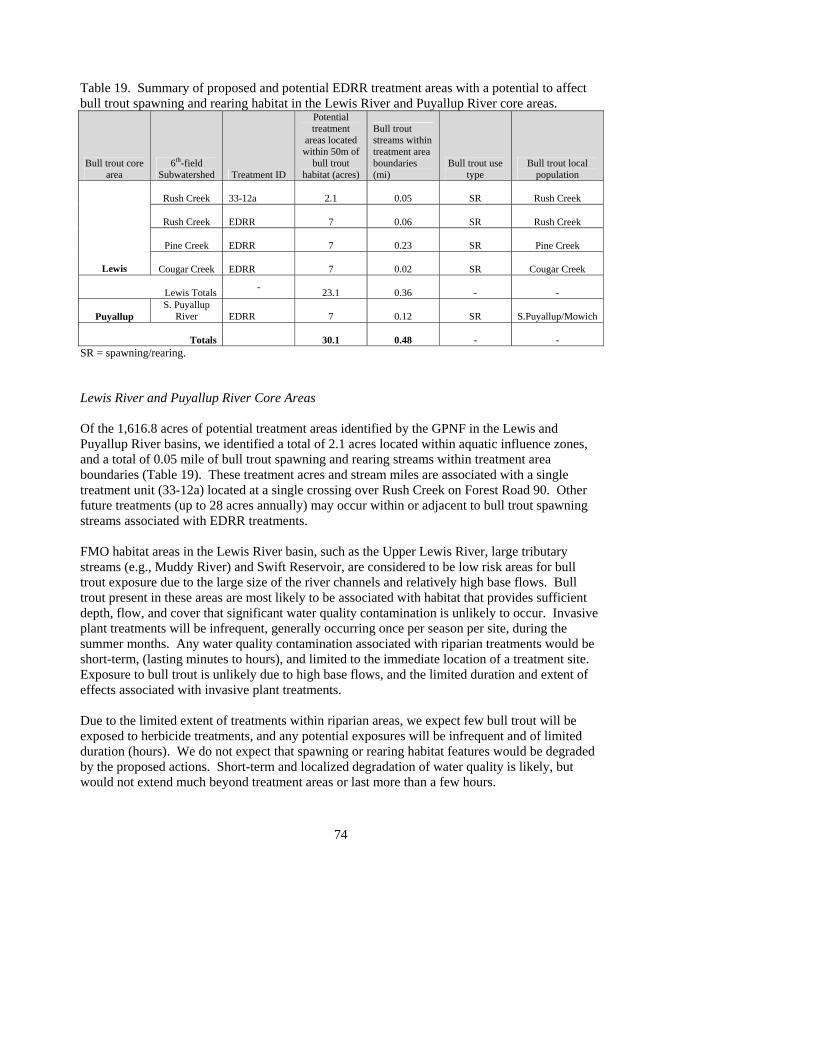
74
Table 19. Summary of proposed and potential EDRR treatment areas with a potential to affect bull trout spawning and rearing habitat in the Lewis River and Puyallup River core areas.
Bull trout core area
6th-field Subwatershed Treatment ID
Potential treatment
areas located within 50m of
bull trout habitat (acres)
Bull trout streams within treatment area boundaries (mi)
Bull trout use type
Bull trout local population
Rush Creek 33-12a 2.1 0.05 SR Rush Creek
Rush Creek EDRR 7 0.06 SR Rush Creek
Pine Creek EDRR 7 0.23 SR Pine Creek
Lewis
Cougar Creek EDRR 7 0.02 SR Cougar Creek
Lewis Totals - 23.1 0.36 - -
Puyallup S. Puyallup
River EDRR 7 0.12 SR S.Puyallup/Mowich
Totals 30.1 0.48 - - SR = spawning/rearing. Lewis River and Puyallup River Core Areas Of the 1,616.8 acres of potential treatment areas identified by the GPNF in the Lewis and Puyallup River basins, we identified a total of 2.1 acres located within aquatic influence zones, and a total of 0.05 mile of bull trout spawning and rearing streams within treatment area boundaries (Table 19). These treatment acres and stream miles are associated with a single treatment unit (33-12a) located at a single crossing over Rush Creek on Forest Road 90. Other future treatments (up to 28 acres annually) may occur within or adjacent to bull trout spawning streams associated with EDRR treatments. FMO habitat areas in the Lewis River basin, such as the Upper Lewis River, large tributary streams (e.g., Muddy River) and Swift Reservoir, are considered to be low risk areas for bull trout exposure due to the large size of the river channels and relatively high base flows. Bull trout present in these areas are most likely to be associated with habitat that provides sufficient depth, flow, and cover that significant water quality contamination is unlikely to occur. Invasive plant treatments will be infrequent, generally occurring once per season per site, during the summer months. Any water quality contamination associated with riparian treatments would be short-term, (lasting minutes to hours), and limited to the immediate location of a treatment site. Exposure to bull trout is unlikely due to high base flows, and the limited duration and extent of effects associated with invasive plant treatments. Due to the limited extent of treatments within riparian areas, we expect few bull trout will be exposed to herbicide treatments, and any potential exposures will be infrequent and of limited duration (hours). We do not expect that spawning or rearing habitat features would be degraded by the proposed actions. Short-term and localized degradation of water quality is likely, but would not extend much beyond treatment areas or last more than a few hours.

75
A few individual juvenile bull trout are likely to be exposed to herbicides, but we do not expect that these exposures will affect bull trout local populations because the effects of the exposure would be short-term (hours), and sub-lethal, such as increased respiration, reduced feeding success, and subtle behavioral changes that can increase predation risk to individuals may occur. The number of reproducing adults is the most important variable influencing bull trout local populations (Whitesel et al. 2004). Spawning adult bull trout would not be adversely affected by the project, because seasonal restrictions that limit the timing for instream projects precludes affects to spawning bull trout or incubating bull trout eggs and alevins. None of the potential adverse effects associated with this action are expected to alter local populations trends through reduced juvenile to adult survival, reduced reproductive capability, or alter the distribution of bull trout within the Lewis and Puyallup core areas. Klickitat River Core Area and Lower Columbia River FMO All proposed treatment areas and potential future treatments under EDRR along the lower Klickitat River core area would occur adjacent to FMO habitat only. Bull trout spawning streams in this core area occur outside the CRGNSA boundary. FMO areas such as the lower mainstem river and the Bonneville Dam reservoir are considered to be low risk areas for bull trout exposure due to the large size of the river channels and relatively high base flows. Bull trout present in these areas are most likely to be associated with habitat that provides sufficient depth, flow, and cover that significant water quality contamination is unlikely to occur. Invasive plant treatments will be infrequent, occurring once per season per site, during the summer months. Any water quality contamination associated with riparian treatments would be short-term, (lasting minutes to hours), and limited to the immediate location of a treatments site. Potential adverse affects to bull trout associated with invasive plant treatments are not anticipated, therefore effects to bull trout associated with the proposed treatments in the Klickitat River core areas is considered to be insignificant. CUMULATIVE EFFECTS Cumulative effects include the effects of future state, tribal, or private actions, not involving Federal actions, that reasonably are certain to occur within the action area of a Federal action subject to consultation (50 CFR 402.2). Future Federal actions that are unrelated to the proposed action that are not considered in this section because they require separate consultation pursuant to section 7 of the Act. Within the administrative boundary of the GPNF/CRGNSA there are interspersed tracts of non-Federal land. Land uses include timber harvest, agriculture and development. We expect that these non-Federal lands are used primarily for timber production. Timber harvest and forest roads management on private lands in Washington have been analyzed and covered under existing HCPs such as the Washington Forest Practices HCP (WDNR 2005). The FWS anticipates non-Federal actions that could affect bull trout are reasonably certain to occur within the action area. These actions include residential development, road management, small-scale agriculture, and bank stabilization projects. We expect that the effects to bull trout

76
associated with these actions will be limited and widely dispersed. The majority of cumulative effects will likely occur within bull trout FMO habitat where the greatest concentration of non-Federal lands occur. Within the range of bull trout on the GPNF/CRGNSA, most of the known bull trout spawning and rearing habitat occurs on Federal lands within the boundaries of the GPNF. CONCLUSION Under Section 7(a)(2) of the Act, Federal agencies must ensure that activities are not likely to jeopardize the continued existence of any listed species. Regulations implementing this section of the Act define “jeopardize the continued existence of” as “to engage in an action that reasonably would be expected, directly or indirectly, to reduce appreciably the likelihood of both the survival and recovery of a listed species in the wild by reducing the reproduction, numbers, or distribution of that species” (50 CFR 402.02). After reviewing the status of the bull trout, the environmental baseline for the action area, the effects of the proposed action and cumulative effects, it is the FWS biological opinion that implementation of the proposed project is not likely to jeopardize the continued existence of bull trout. We reached this conclusion based on the following rationale:
Bull Trout Reproduction, Numbers, and Distribution
Due to the limited extent of treatments within riparian areas, we expect few bull trout will be exposed to herbicide treatments, and any potential exposures will be infrequent and of limited duration (hours). Any toxicological effects of the proposed action on bull trout are likely to be from sub-lethal exposures to aquatic formulations of glyphosate or triclopyr. Herbicides proposed for use by the GPNF/CRGNSA are not expected to reach streams in concentrations that would kill bull trout, or in sufficient quantity to degrade water quality beyond treatment site locations. Fry and juveniles are the bull trout life stages most likely to be exposed. Spawning adult bull trout would not be adversely affected by the project, because seasonal restrictions that limit inwater work to the summer months precludes affects to spawning bull trout or incubating bull trout eggs and alevins. The number of individuals potentially exposed is expected to be low, and limited to the scale of individual project sites. Potential exposures to herbicides would be brief (minutes to hours), and may result in sublethal effects that are not expected to reduce reproductive success. Water quality is expected to return to background levels within minutes to hours. We do not expect that these short-term exposures will appreciably reduce the likelihood of survival and recovery of bull trout within the Coastal-Puget Sound or Lower Columbia River interim recovery units or the coterminous range. Treatment of invasive plants will provide for long-term ecosystem maintenance and restoration of native vegetation that provides essential habitat features for bull trout. Invasive plants have the potential to completely alter and disrupt native ecosystems if not controlled in time, to the detriment of native species that depend upon those ecosystems. Effective invasive plant

77
treatment and restoration of treated sites is expected to provide long-term beneficial effects to bull trout through restoration of riparian communities which will ultimately lead to improved fish habitat conditions.
INCIDENTAL TAKE STATEMENT
Section 9 of the Act and Federal regulation pursuant to section 4(d) of the Act prohibit the take of endangered and threatened species, respectively, without special exemption. Take is defined as to harass, harm, pursue, hunt, shoot, wound, kill, trap, capture or collect, or to attempt to engage in any such conduct. Harm in the definition of “take” in the Act means an act which actually kills or injures wildlife. Such acts may include significant habitat modification or degradation where it actually kills or injures wildlife by significantly impairing essential behavior patterns, including breeding, feeding, or sheltering (50 CFR section17.3). Harass in the definition of “take” in the Act means an intentional or negligent act or omission which creates the likelihood of injury to wildlife by annoying it to such an extent as to significantly disrupt normal behavioral patterns which include, but are not limited to, breeding, feeding, or sheltering (50 CFR section 17.3). Incidental take is defined as take that is incidental to, and not the purpose of, the carrying out of an otherwise lawful activity. Under the terms of section 7(b)(4) and section 7(o)(2), taking that is incidental to and not intended as part of the agency action is not considered to be prohibited taking under the Act provided that such taking is in compliance with the terms and conditions of this Incidental Take Statement. The measures described below are non-discretionary, and must be undertaken by the FS for the exemption in section 7(o)(2) to apply. The FS has a continuing duty to regulate the activity covered by this Incidental Take Statement. If the FS fails to assume and implement the terms and conditions of the Incidental Take Statement through enforceable terms that are added to the permit or grant document, the protective coverage of section 7(o)(2) may lapse. In order to monitor the impact of incidental take, the FS must report the progress of the action and its impact on the species to the FWS as specified in the Incidental Take Statement. Amount or Extent of Take As described in the effects of action discussion, the FWS expects that the protective riparian buffers, minimization measures, and restricted application methods proposed by the GPNF/CRGNSA will prevent herbicides from causing incidental take of bull trout under most treatment scenarios. However, some treatment actions may cause incidental take of bull trout. The incidental take is expected to be in the form of non-lethal harm, caused by short-term exposures of bull trout to sub-lethal concentrations of herbicides and associated compounds. Sub-lethal effects include short-term impairments (hours) of normal functions and behaviors such as olfaction, respiration, and feeding. These effects may occur as a result of herbicide applications (e.g., emergent vegetation treatments, riparian applications, or applications in roadside ditches and intermittent streams which connect directly to bull trout rearing habitat). Herbicides proposed for use by the GPNF/CRGNSA are not expected to reach streams in concentrations that would kill bull trout.

78
Despite the use of best scientific and commercial data available, the FWS cannot quantify the specific number of individual fish that will be incidentally taken by this action. The Service anticipates that incidental take of individual bull trout would be difficult to detect or quantify because of the sublethal nature of the take and the low likelihood of finding the affected juveniles or adults. We expect that the number of individual fish exposed to sub-lethal concentrations of herbicides will be low, will be limited to juveniles, and would only be associated with treatments within and adjacent to bull trout spawning and rearing habitat. In the absence of sufficient data to quantify the number of individuals affected, the FWS relies on estimates of habitat affected as a reasonable surrogate for describing the extent of take. The GPNF has identified potential treatment areas along 0.05 mile of bull trout spawning streams within the Lewis River basin where the FWS considers take of a small number of juvenile bull trout is likely to occur:
Bull Trout Core Area
Potential treatment acres in Aquatic Influence Zones adjacent to bull trout spawning habitat
Miles of bull trout spawning streams located within or adjacent to potential treatment areas
Lewis River 2.1 0.05 Although we have identified approximately 2.1 acres of potential treatment areas adjacent to bull trout streams, project implementation in these areas is uncertain, and will fall under the same restrictions applied to future invasive plant management under the “early detection, rapid response” (EDRR) program:
1. Treatments above bankfull, within the aquatic influence zone, would not exceed 10 acres along any 1.5 mile of stream reach within a 6th field subwatershed in any given year, and
2. Treatments below bankfull would not exceed 7 acres total within a 6th field subwatershed
in any given year. The FWS considers the following 6th field watersheds with bull trout spawning and rearing habitat to be the only areas on the Forest where take of bull trout is likely to occur under EDRR treatments:
Bull Trout Core Area
6th-field subwatershed
with bull trout spawning and rearing
Maximum annual below- bankfull treatments
Estimated miles of bull trout habitat associated with EDRR treatments
Rush Creek 7 acres 0.06
Pine Creek 7 acres 0.23 Lewis River
Cougar Creek 7 acres 0.02
Puyallup River S. Puyallup River 7 acres 0.12
Gifford Pinchot National Forest Totals 28 acres 0.43

79
As stated above, the FWS expects that the protective riparian buffers, minimization measures, and restricted application methods proposed by the GPNF/CRGNSA will prevent herbicides from causing incidental take of bull trout under most treatment scenarios. However, the PDCs do not completely eliminate the potential for incidental take since herbicides may be used in sites where they are likely to reach water where bull trout are present. Effect of the Take In the accompanying BO, we determined that this level of anticipated incidental take is not likely to jeopardize the continued existence of bull trout. Reasonable and Prudent Measures The FWS believes that full application of conservation measures included as part of the proposed action, together with use of the Reasonable and Prudent Measures (RPMs) and terms and conditions described below, are necessary and appropriate to minimize the likelihood of incidental take of bull trout due to completion of the proposed action. The GPNF/CRGNSA shall minimize incidental take by:
1. Minimize the amount and extent of incidental take from use of herbicides by implementing precautionary measures that keep chemicals out of water.
2. Reporting annual invasive plant control proposals to the FWS via the Level 1 Team by
March 1, prior to the start of the spray season (2008 to 2012). The proposals will include the treatment methods, herbicide application methods and rates, objectives of treatments, locations, maps of treatment areas, acreages, proposed start and stop dates, and special mitigation measures that will be applied.
3. Annually reporting by January 31 to the FWS on activities implemented during the 2008
to 2012 seasons and the results of Regional monitoring efforts. If no activities occur, a report of no action is still required by January 31, following each spray season (2008 to 2012).
Terms and Conditions In order to be exempt from the prohibitions of section 9 of the Act, the (agency) must comply with the following terms and conditions, which implement the reasonable and prudent measures described above and outline required reporting/monitoring requirements. These terms and conditions are non-discretionary:

80
1. To implement RPM #1 and the GPNF/CRGNSA shall:
a. Herbicide applicators will obtain a weather forecast for the area prior to applying herbicides to ensure no imminent precipitation or wind events are likely to occur during or immediately after spraying.
b. To the extent practicable, limit the use of herbicides at maximum application rates to
hand/select methods, specifically glyphosate and triclopyr applications within aquatic influence zones.
2. To implement RPM #2 and the GPNF/CRGNSA shall:
a. Develop annual invasive plant treatment plans with the FWS including treatment
methods, herbicide application methods and rates, objectives of treatments, locations, maps of treatment areas, acreage, proposed start and completion dates, sensitive areas, and special mitigation for activities involving herbicides by March 1, prior to the spray season. We recognize that not all treatments under the EDRR program may be identified prior to March 1. These actions will be included in the annual year-end report. The pre-project reporting requirement will commence on March 1, 2008; will follow for each subsequent spraying season on March 1; and will end for this consultation on December 31, 2012. The annual invasive plant treatment plans should contain the following information for projects planned in bull trout core area watersheds:
i. Location: 6th field HUC, 12 digit code, and name
ii. Timing: Anticipated project start and dates iii. Treatment/Restoration Type: Identify all proposed activity types that apply. iv. Project Description: Brief narrative of the project and objectives v. Extent: Number of stream miles or acres of below-bankfull treatments, and
number of riparian acres to be treated. vi. Species Affected: Listed fish and or wildlife species or critical habitat
affected by the project.
3. To implement RPM #3, the GPNF/CRGNSA shall:
a. Using the format of the annual invasive plant treatment plan listed above, annually report to FWS by January 31, following the end of each spray season for the duration of this BO (2008 to 2012 spray seasons), the results of the project implementation and results of Regional monitoring efforts for projects implemented in bull trout core area watersheds:
i. Timing: Actual project start and end dates
ii. GPNF/CRGNSA contact information: Project lead name iii. Post-project assessment: Report the results of monitoring efforts completed
under the Regional Monitoring Framework.

81
The FWS is to be notified within three working days upon locating a dead, injured, or sick endangered or threatened species specimen. Initial notification must be made to the nearest U.S. FWS Law Enforcement Office at (425) 883-8122, or the Western Washington Fish and Wildlife Office at (360) 753-9440. Notification must include the date, time, precise location of the injured animal or carcass, and any other pertinent information. Care should be taken in handling sick or injured specimens to preserve biological materials in the best possible state for later analysis. In conjunction with the care of sick or injured endangered or threatened species or preservation of biological materials from a dead animal, the finder has the responsibility to ensure that evidence associated with the specimen is not unnecessarily disturbed. The FWS believes that take of bull trout could occur as a result of the proposed action. The RPMs, with its implementing terms and conditions, are designed to minimize the impact of incidental take that might otherwise result from the proposed action. If, during the course of the action, this level of incidental take is exceeded, such incidental take represents new information requiring reinitiation of consultation and review of the RPMs provided. The FS must immediately provide an explanation of the causes of the taking and review with the FWS the need for possible modification of the RPMs. Conservation Recommendations Section 7(a)(1) of the Act directs Federal agencies to utilize their authorities to further the purposes of the Act by carrying out conservation programs for the benefit of endangered and threatened species. Conservation recommendations are discretionary agency activities that can be implemented to further the purposes of the Act, such as preservation of endangered species habitat, implementation of recovery actions, or development of information and data bases. The FWS has the following recommendations:
1. Use herbicide formulations with the least toxicity to fish and other aquatic organisms whenever possible.
2. Continue to investigate the utility of alternate forms of weed control that do not involve
the use of chemicals toxic to aquatic organisms.
3. Monitor invasive plant treatment sites to determine if expected beneficial habitat changes take place.
4. For the purposes of bull trout recovery and conservation, assess and inventory suitable
bull trout streams on the National Forest to further refine the known distribution of bull trout within the GPNF/CRGNSA.
In order for the FWS to be kept informed of actions minimizing or avoiding adverse effects or benefiting listed species or their habitats, the FWS requests notification of the implementation of any conservation recommendations.

82
Reinitiation Notice This concludes formal consultation on the proposed action. This consultation is valid through December 31, 2012. To avoid a lapse in coverage, consultation must be reinitiated with sufficient time to complete consultation prior to that date. As provided in 50 CFR section 402.16, reinitiation of formal consultation is required where discretionary federal agency involvement or control over the action has been maintained (or is authorized by law) and if: (1) the amount or extent of incidental take is exceeded; (2) new information reveals effects of the agency action that may affect listed species or critical habitat in a manner or to an extent not considered in this BO; (3) the agency action is subsequently modified in a manner that causes an effect to the listed species or critical habitat that was not considered in this BO; or (4) a new species is listed or critical habitat designated that may be affected by the action. In instances where the amount or extent of incidental take is exceeded, any operations causing such take must cease pending reinitiation.

83
LITERATURE CITED Baxter, C.V. 2002. Fish movement and assemblage dynamics in a Pacific Northwest riverscape.
Ph.D. Thesis, Oregon State University, Corvallis, Oregon.
Baxter, J.S., E.B. Taylor, R.H. Devlin, J. Hagen and J.D. McPhail. 1997. Evidence for natural hybridization between Dolly Varden (Salvelinus malma) and bull trout (S. confluentus) in a northcentral British Columbia watershed. Canadian Journal of Fisheries and Aquatic Sciences 54:421-429.
Beauchamp, D.A., and J.J. VanTassell. 2001. Modeling seasonal trophic interactions of adfluvial bull trout in Lake Billy Chinook, Oregon. Transactions of the American Fisheries Society 130:204-216.
Boag, T.D. 1987. Food habits of bull char (Salvelinus confluentus), and rainbow trout (Salmo gairdneri), coexisting in the foothills stream in northern Alberta. Canadian Field-Naturalist 101(1):56-62.
Bond, C.E. 1992. Notes on the nomenclature and distribution of the bull trout and the effects of human activity on the species. Pages 1-4 in: Howell, P.J., and D.V. Buchanan (eds.). Proceedings of the Gearhart Mountain bull trout workshop. Oregon Chapter of the American Fisheries Society, Corvallis, Oregon.
Bonneau, J.L., and D.L. Scarnecchia 1996. Distribution of juvenile bull trout in a thermal gradient of a plunge pool in Granite Creek, Idaho. Transactions of the American Fisheries Society 125(4):628-630.
Brenkman, S.J., and S.C. Corbett. 2005. Extent of anadromy in bull trout and implications for conservation of a threatened species. North American Journal of Fisheries Management 25:1073-1081.
Brewin, P.A., and M.K. Brewin. 1997. Distribution maps for bull trout in Alberta. Pages 209-216 in: MacKay, W.C., M.K. Brewin, and M.Monia (eds.). Friends of the Bull Trout Conference Proceedings. Bull Trout Task Force (Alberta), c/o Trout Unlimited, Calgary.
Brown, L.G. 1994. The zoogeography and life history of WA native charr. Report #94-04 November 1992. Washington Department of Fish and Wildlife, Fisheries Management Division, Olympia, Washington.
Buchanan, D.M., and S.V. Gregory. 1997. Development of water temperature standards to protect and restore habitat for bull trout and other cold water species in Oregon. Pages 1-8 in: Mackay, W.C., M.K. Brewin and M. Monita (eds.). Friends of the Bull Trout Conference Proceedings. Bull Trout Task Force (Alberta), c/o Trout Unlimited Calgary, Alberta, Canada.

84
Caltrans. 2005. First flush phenomenon characterization. California Department of Transportation, report #CTSW-RT-05-73-02.6. http://www.dot.ca.gov/hq/env/stormwater/pdf/CTSW-RT-05-073-02-6_First_Flush_Final_9-30-05.pdf
Cavender, T.M. 1978. Taxonomy and distribution of the bull trout, (Salvelinus confluentus) (Suckley), from the American Northwest. California Fish and Game 64(3):139-174.
Donald, D.B., and D.J. Alger. 1993. Geographic distribution, species displacement, and niche overlap for lake trout and bull trout in mountain lakes. Canadian Journal of Zoology 71:238-247.
Dunham, J.B., B.E. Rieman, and G. Chandler. 2003. Influence of temperature and environmental variables on the distribution of bull trout within streams at the southern margin of its range. North American Journal of Fisheries Management 23:894-904.
Fairchild, J.F., A.L. Allert, K.P. Feltz, K.J. Nelson, and J.A. Valle. 2006. A comparative aquatic risk assessment of rainbow trout (Onchorynchus mykiss) and the threatened bull trout (Salvelinus confluentus) exposed to common forest-use herbicides. U.S. Geological Survey. Unpublished agency report on file at the Western Washington Fish and Wildlife Office, Lacey, WA.
Fraley, J.J., and B.B. Shepard. 1989. Life history, ecology, and subpopulation status of migratory bull trout (Salvelinus confluentus) in the Flathead Lake and River system, Montana. Northwest Science 63:133-143.
Frissell, C.A. 1993. Topology of extinction and endangerment of native fishes in the Pacific Northwest and California. Conservation Biology 7(2):342-354.
Frissell, C.A. 1999. An ecosystem approach to habitat conservation for bull trout: groundwater and surface water protection. Open File report Number 156-99. Flathead Lake Biological Station, University of Montana. Polson, Montana.
Gerking, S.D. 1994. Feeding Ecology of Fish. Academic Press, San Diego, California.
Goetz, F. 1989. Biology of the bull trout, Salvelinus confluentus, literature review. Willamette National Forest, Eugene, Oregon.
Goetz, F.A., E. Jeanes, and E. Beamer. 2004. Bull trout in the nearshore. Preliminary draft. U.S. Army Corps of Engineers, Seattle, Washington.
Groot, C., and L. Margolis. 1991. Pacific salmon life histories. UBC Press, University of British Columbia, Vancouver, BC. 564 pp.
Hiss, J., T. Lawson, and K. Meyer. 2000. Gifford Pinchot National Forest bull trout consultation baseline. Version 6.2. Unpublished agency report. U.S. Fish and Wildlife Service, Western Washington Fish and Wildlife Office, Lacey, Washington, and U.S. Forest Service, Gifford Pinchot National Forest, Vancouver, Washington.

85
Hiss, J., J. Byrne, and K. Thompson. 2004. An assessment of potential summer habitat for bull trout (Salvelinus confluentus) in the Lewis River watershed upstream of the Swift Creek Reservoir, Skamania County, Washington. Draft report. U.S. Fish and Wildlife Service, Western Washington Fish and Wildlife Office, Lacey, Washington.
Hoelscher, B., and T.C. Bjornn. 1989. Habitat, density, and potential production of trout and char in Pend Oreille Lake tributaries. Project F-710R-10, Subproject III, Job No. 8. Idaho Department of Fish and Game, Boise, Idaho.
Howell, P.J., and D.V. Buchanan. 1992. Proceedings of the Gearhart Mountain Bull Trout Workshop. Oregon Chapter of the American Fisheries Society, Corvallis, Oregon.
Lagler, K.F., J.E. Bardach, R.R. Miller, and D.R. M. Passino. 1977. Ichthyology. John Wiley & Sons, Inc., New York. 506 pp.
Leary, R.F., and F.W. Allendorf. 1997. Genetic confirmation of sympatric bull trout and Dolly Varden in western Washington. Transactions of the American Fisheries Society 126:715-720.
Leathe, S.A., and P. Graham. 1982. Flathead Lake fish food habits study. Environmental Protection Agency, through Steering Committee for the Flathead River Basin Environmental Impact Study. Contract R008224-01-4 to Montana Department of Fish, Wildlife, and Parks.
The Montana Bull Trout Scientific Group. (MBTSG) 1998. The relationship between land management activities and habitat requirements of bull trout. Prepared for the Montana Bull Trout Restoration Team, Montana Fish, Wildlife, and Parks, Helena, Montana. 85 pp.
McPhail, J.D., and J.S. Baxter. 1996. A review of bull trout (Salvelinus confluentus) life-history and habitat use in relation to compensation and improvement opportunities. Fisheries Management Report No. 104. Department of Zoology, University of British Columbia, Vancouver, British Columbia.
McPhail, J.D., and C. Murray. 1979. The early life history of Dolly Varden (Salvelinus malma) in the upper Arrow Lakes. Report to the British Columbia Hydro and Power Authority and Kootenai Department of Fish and Wildlife. University of British Columbia, Department of Zoology and Institute of Animal Resources, Vancouver, British Columbia.
Myrick, C.A., F.T. Barrow, J.B. Dunham, B.L. Gamett, G. Haas, J.T. Peterson, B. Rieman, L.A. Weber, and A.V. Zale. 2002. Bull trout temperature thresholds. Peer review summary prepared for U.S. Fish and Wildlife Service.
Norris, L.A., H.W. Lorz, and S.V. Gregory. 1991. Forest chemicals. Pages 207 – 296 in: Influences of forest and rangeland management on salmonid fishes and their habitats. W.R. Meehan, editor. American Fisheries Society special publication 19. Bethesda, MD.

86
PacifiCorp. 2003. Results of bull trout monitoring activities in the North Fork Lewis River. 2003 annual report. PacifiCorp, Hydro Compliance, Portland, Oregon.
PacifiCorp, Cowlitz PUD, NOAA Fisheries, National Park Service, US Bureau of Land Management, US Fish and Wildlife Service, USDA Forest Service, Confederated Tribes and Bands of the Yakama Nation, Cowlitz Indian Tribe, Washington Department of Fish and Wildlife, Washington Department of Natural Resources, Interagency Committee for Outdoor Recreation, Clark County, Cowlitz County, Skamania County, Cowlitz-Skamania Fire District No. 7, North Country Emergency Medical Service, City of Woodland, Woodland Chamber of Commerce, Lewis River Community Council, Lewis River Citizens-at-Large, Lower Columbia Fish Recovery Board, American Rivers, Fish First and Rocky Mountain Elk Foundation, Inc. 2004. Final Settlement Agreement Concerning the Relicensing of the Lewis River Hydroelectric Projects. November 30, 2004.
Pratt, K.L. 1985. Habitat use and species interactions of juvenile cutthroat, Salmo clarki, and bull trout, Salvelinus confluentus, in the upper Flathead River basin. Masters Thesis, University of Idaho, Moscow.
Pratt, K.L. 1992. A review of bull trout life history. Pages 5-9 in: Howell, P.J., and D.V. Buchanan (eds.). Proceedings of the Gearhart Mountain bull trout workshop. Oregon Chapter of the American Fisheries Society, Corvallis, Oregon.
Pratt, K.L., and J.E. Huston. 1993. Status of bull trout (Salvelinus confluentus) in lake Pend Oreille and the lower Clark Fork River. Draft report. Prepared for the Washington Water Power Company, Spokane, Washington.
Quigley, Thomas M., and Sylvia J. Arbelbide (tech. eds.). 1997. An assessment of ecosystem components in the Interior Columbia Basin and portions of the Klamath and Great Basins. Portland, Oregon. U.S. Department of Agriculture, Forest Service, Pacific Northwest Research Station 3:1174-1185.
Ratliff, D.E., and P.J. Howell. 1992. The status of bull trout populations in Oregon. Pages 10 -17 in: Howell, P.J. and D.V. Buchanan (eds.). Proceedings of the Gearhart Mountain Bull Trout Workshop. Oregon Chapter of the American Fisheries Society, Corvallis, Oregon.
Rehnberg, B.G., B. Jonasson, and C. B. Schreck. 1985. Olfactory sensitivity during parr and smolt developmental stages in coho salmon. Transactions of the American Fisheries Society 114:732-736.
Rich, C.F., Jr. 1996. Influence of abiotic and biotic factors on occurrence of resident bull trout in fragmented habitats, western Montana. Masters Thesis, Montana State University, Bozeman.
Rieman, B.E., and J.D. McIntyre. 1993. Demographic and habitat requirements for conservation of bull trout. U.S. Department of Agriculture, Forest Service, Intermountain Research Station, General Technical Report INT-302, Ogden, Utah. 38 pp.

87
Rieman, B.E., and J.D. McIntyre. 1995. Occurrence of bull trout in naturally fragmented habitat patches of varied size. Transactions of the American Fisheries Society 124 (3):285-296.
Rieman, B.E., and J.D. McIntyre. 1996. Spatial and temporal variability in bull trout redd counts. North American Journal of Fisheries Management 16:132-141.
Rieman, B.E., D.C. Lee, and R.F. Thurow. 1997. Distribution, status and likely future trends of bull trout within the Columbia River and Klamath River basins. North American Journal of Fisheries Management 17:1111-1125.
Rieman, B.E., D. Lee, D. Burns, R. Gresswell, M. Young, R. Stowell, P. Howell. 2003. Status of native fishes in western United States and issues for fire and fuels management. Forest Ecology and Management 178(1-2):197-211.
Sedell, J.R., and F.H. Everest. 1991. Historic changes in pool habitat for Columbia River Basin salmon under study for TES listing. Draft U.S. Department of Agriculture Report, Pacific Northwest Research Station, Corvallis, Oregon.
Syracuse Environmental Research Associates, Inc. (SERA) 2001. Sethoxydim [Poast] - Human Health and Ecological Risk Assessment Final Report. SERA TR 01-43-01-01c. October 31, 2001.
Syracuse Environmental Research Associates, Inc. (SERA) 2003. Glyphosate- Human Health and Ecological Risk Assessment Final Report. SERA TR 02-43-09-04a. March 1, 2003.
Syracuse Environmental Research Associates, Inc. (SERA) 2003a. Picloram - Revised Human Health and Ecological Risk Assessment Final Report. SERA TR 03-43-26-01b. June 30, 2003.
Syracuse Environmental Research Associates, Inc. (SERA) 2003b. Triclopyr - Revised Human Health and Ecological Risk Assessments Final Report. SERA TR 02-43-13-03b. March 15, 2003.
Sexauer, H.M., and P.W. James. 1997. Microhabitat use by juvenile trout in four streams located in the eastern Cascades, Washington. Pages 361-170 in: MacKay, W.C., M.K. Brewin, and M. Monita (eds.). Friends of the Bull Trout Conference Proceedings. Bull Trout Task Force (Alberta), c/o Trout Unlimited Calgary, Alberta, Canada.
Simpson, J.C., and R.L. Wallace. 1982. Fishes of Idaho. University of Idaho Press, Moscow, Idaho.
Spruell, P., B.E. Rieman, K.L. Knudsen, F.M. Utter, and F.W. Allendorf. 1999. Genetic population structure within streams: microsatellite analysis of bull trout populations. Ecology of Freshwater Fish 8:114-121.

88
Tierney, K.B., P.S. Ross, H.E. Jarrard, K.R. Delaney, and C.J. Kennedy. 2006. Changes is juvenile coho salmon electro-olfactogram during and after short-term exposure to current use pesticides. Environmental Toxicology and Chemistry, Vol. 25, No. 10, pp 2809-2817.
Thomas, G. 1992. Status of bull trout in Montana. Report prepared for Montana Department of Fish, Wildlife and Parks, Helena, Montana.
U.S. Environmental Protection Agency. 1994. EPA Reregistration decision for glyphosate. EPA 738-R-93-014. U.S. Environmental Protection Agency; Office of Prevention, Pesticides, and Toxic Substances; Office of Pesticide Programs, Washington, D.C. 259 pp.
U.S. Environmental Protection Agency. 2004. Overview of the Ecological Risk Assessment process in the Office of Pesticide Programs, U.S. Environmental Protection Agency; Endangered and Threatened Species Effects Determinations. Office of Prevention, Pesticides, and Toxic Substances; Office of Pesticide Programs, Washington, D.C. 92 pp.
U.S. Fish and Wildlife Service. 2002. Bull trout (Salvelinus confluentus) draft recovery plan. Chapter One. Fish and Wildlife Service, Portland, Oregon. 137 pp.
U.S. Fish and Wildlife Service. 2002a. Bull trout (Salvelinus confluentus) draft recovery plan. Chapter 20, Lower Columbia River recovery unit. U.S. Fish and Wildlife Service, Portland, Oregon. 88 pp.
U.S. Fish and Wildlife Service. 2004a. Draft recovery plan for the Jarbridge River distinct population segment of bull trout (Salvelinus confluentus). Fish and Wildlife Service, Portland, Oregon. May 2004.132 pp +xiii.
U.S. Fish and Wildlife Service. 2004b. Draft Recovery Plan for the Coastal-Puget Sound Distinct Population Segment of Bull Trout (Salvelinus confluentus). Volume I: Puget Sound Management Unit, 389+xvii pp and Volume II: Olympic Peninsula Management Unit, Portland, Oregon. 277+xvi pp.
U.S. Fish and Wildlife Service. 2005. Bull trout core area template-complete core area by core area analysis. Fredenberg, W. and J. Chan (eds.). U.S. Fish and Wildlife Service, Portland, Oregon.
U.S. Forest Service. 2000. Rock Creek watershed analysis. Gifford Pinchot National Forest, Mt. Adams Ranger District. Trout Lake, Washington.
U.S. Forest Service. 2001a. Wind River watershed analysis, 2nd iteration. Gifford Pinchot National Forest, Mt. Adams Ranger District. Trout Lake, Washington.
U.S. Forest Service. 2001b. Bull trout survey report submitted to U.S. Fish and Wildlife Service, Western Washington Fish and Wildlife Office, Lacey, Washington. February 2001. U.S. Forest Service, Gifford Pinchot National Forest, Vancouver, Washington.

89
U.S. Forest Service. 2003. Biological Assessment. USDA Forest Service programmatic activities affecting Columbia River and Coastal-Puget Sound Bull Trout, Lower Columbia River Steelhead, Middle Columbia River Steelhead, Puget Sound Chinook Salmon, Lower Columbia River Chinook Salmon, Lower Columbia Southwest Washington Coho, Columbia River Chum, Proposed Critical Habitat for Bull Trout, and Essential Fish Habitat – Gifford Pinchot National Forest - Columbia River Gorge National Scenic Area, Washington. Gifford Pinchot National Forest, Vancouver, WA. October, 2003.
U.S. Forest Service. 2005. Final Environmental Impact Statement and Record of Decision for the Pacific Northwest Invasive Plant Program – preventing and managing invasive plants. R6-NR FHP-PR-02-05. April 2005. Record of Decision document signed October 2005. Pacific Northwest Region, Portland, OR.
U.S. Forest Service. 2005a. Biological Assessment for the USDA Forest Service Pacific Northwest Region Invasive Plant Program. Pacific Northwest Region, US Forest Service. 453 pp. plus appendices.
U.S. Forest Service. 2006. Draft Environmental Impact Statement for Gifford Pinchot National Forest and Columbia River Gorge National Scenic Area (Washington portion) site specific invasive plant treatments. August 2006. U.S. Forest Service, Pacific Northwest Region, Vancouver, WA.
U.S. Forest Service. 2007. Biological assessment for the USDA Forest Service Gifford Pinchot National Forest and Columbia River Gorge National Scenic Area invasive plant treatment project. January 19, 2007. Gifford Pinchot National Forest, Vancouver, WA. 264 pp. plus appendices.
U.S. Geological Service (USGS) 2001. Herbicide use in the management of roadside vegetation, western Oregon, 1999-2000: Effects on the water quality of nearby streams. U.S. Geological Survey, Portland, Oregon. Water resources report 01-0465, 27p.
Watson, G., and T.W. Hillman. 1997. Factors affecting the distribution and abundance of bull trout: an investigation at hierarchical scales. North American Journal of Fisheries Management 17:237-252.
Washington Department of Fish and Wildlife (WDFW). 1998. Washington State salmonid stock draft inventory: bull trout/Dolly Varden. Washington Department of Fish and Wildlife, Olympia, WA.
Washington Department of Fish and Wildlife (WDFW). 2000. Bull trout population assessment in the Columbia River Gorge. FY-2000 annual report. Vancouver, Washington.
Washington Department of Fish and Wildlife (WDFW), FishPro Inc., and Beak Consultants. 1997. Grandy Creek trout hatchery biological assessment. March 1997. Olympia, Washington.

90
Washington Department of Natural Resources (WDNR). 2005. Forest Practices Habitat Conservation Plan – Final. Washington Dept. of Natural Resources, Olympia, WA. http://www.dnr.wa.gov/htdocs/agency/federalassurances/final_fphcp/index.html
Washington State Department of Agriculture (WSDA). 2003. 2003 freshwater emergent noxious and quarantine weed water quality group monitoring plan results.
Washington State Department of Agriculture (WSDA). 2005. 2004 freshwater emergent noxious and quarantine weed water quality group monitoring plan results. Prepared by G. Haubrich and B. Archbold. January, 2005.
Washington State Department of Agriculture (WSDA). 2006. 2005 freshwater emergent noxious and quarantine weed water quality group monitoring plan results. Prepared by G. Haubrich. January, 2006.
Whitesel, T.A., and 7 coauthors. 2004. Bull trout recovery planning: a review of the science associated with population structure and size. Science Team Report #2004-01, U.S. Fish and Wildlife Service, Regional Office, Portland, Oregon, USA. Available online at http://www.fws.gov/columbiariver/scienceteam.htm.
WSCC (Washington State Conservation Commission). 1999. Salmon and steelhead habitat limiting factors, Water Resource Inventory Area 29 (Wind-White Salmon River). Olympia, Washington.
WSCC (Washington State Conservation Commission). 2001. Salmon and steelhead habitat limiting factors, Water Resource Inventory Area 28 (Washougal River). Olympia, Washington.
In Litt REFERENCES
Gilpin, M., University of California, San Diego. 1997. Bull trout connectivity on the Clark Fork River. Letter to Shelley Spalding, Montana Department of Fish, Wildlife and Parks, Helena, Montana.
Idaho Department of Fish and Game, in litt. 1995. List of streams compiled by IDEG where bull trout have been extirpated, fax from Bill Horton, IDFG, to Trish Klahr, U.S. Fish and Wildlife Service, Boise, Idaho. 3 pp.
PERSONAL COMMUNICATIONS
Gamett, B. 2002. U.S. Forest Service. Telephone conversation 06/20/02 with Shelley Spalding,
U.S. Fish and Wildlife Service. (Subject: relationship between water temperature and bull trout distribution and abundance in the Little Lost River, Idaho.).

91
APPENDIX A – Common Control Measures for Invasive Plants Species Source: Table 12, pages 39 – 48 in DEIS (U.S. Forest Service 2006). Target Species – Common and
Scientific Names and
Growth Habit
Estimated Treatment
Acres Documented
Effective Herbicides When/How to treat with
Herbicides Integrated
Control Measures Spotted knapweed (Centaurea biebersteinii) Diffuse knapweed (Centaurea diffusa) Meadow knapweed (Centaurea debeauxii) Brownray knapweed (Centaurea jacea) Biennial or perennial
696 (Gifford Pinchot) 133 (Columbia River Gorge)
Upland: A - Clopyralid, B - Picloram Areas having risk of herbicide delivery to surface waters /High Water Table/Porous Soils: Aquatic labeled Glyphosate
Roadsides: Broadcast spray in dense cover or where dominant plant community is non-native. Otherwise, spot spray on smaller, less dense, patchy roadside infestations. Follow PDC: they may require a less impacting treatment choice. Non-roadside sites: Spot or hand treat. Treat in spring before bud stage. Yearly revisits would be necessary; the number of which is dependent on the chemical used and the seed bank.
- Hand pull or dig small populations or when volunteer labor is available. Multiple entries per year are required. - Manual Disposal: Remove entire root system from the site, as re-growth can occur. -Mowing is possible, but timing is critical. - Manual treatments may take up to ten years due to long term seed viability. - Revegetate with desirable species in accordance with the Restoration Plan.

92
Target Species – Common and
Scientific Names and
Growth Habit
Estimated Treatment
Acres Documented
Effective Herbicides When/How to treat with
Herbicides Integrated
Control Measures Yellow star thistle (Centaurea solstitialis) Annual
286 (Columbia River Gorge)
Upland: A - Clopyralid, B - Picloram Areas having risk of herbicide delivery to surface waters /High Water Table/Porous Soils: Aquatic labeled Glyphosate
Roadsides: Broadcast spray in dense or continuous target vegetation or where dominant plant community is non-native. Otherwise, spot spray on smaller, less dense, patchy roadside infestations. Follow PDC: they may require a less impacting treatment choice. Non-roadside sites: Spot or hand treat. Treat in spring before bud stage. Yearly revisits would be necessary; the number of which is dependent on the chemical used and the seedbank.
- Manual removal is most effective with small patches or where plants are sporadically located. Best time for manual removal is after the plants have bolted and before they produce viable seed. It is important to detach all above ground stem material. Leaving even a two inch piece of stem can result in re-growth if leaves and buds are still attached at the base of the plant. - For large populations, remove plants at the outward edge, working in towards the interior. - Manual Disposal: Remove all flower heads (at any stage of maturity) from site. - Mowing is possible, but timing is critical. Plants must be developed to where the stem branches are above the mowing height, otherwise flowers might still develop. -Manual treatments may take up to ten years due to long term seed viability. - Revegetate with desirable species in accordance with the Restoration Plan.
Japanese knotweed (Polygonum cuspidatum) Perennial
12 (Gifford Pinchot) 2 (Columbia River Gorge)
Upland: A - Glyphosate, B - Triclopyr Areas having risk of herbicide delivery to surface waters: A - Aquatic labeled Glyphosate, B - Aquatic labeled Triclopyr, C- Aquatic labeled Imazapyr
Stems > 3/4": Stem injection; Stems< 3/4": Stem injection or Foliar spray Treat June through September Stem injection may require one or more revisits, and foliar spray may require at least one, depending on the seed bank.
- Herbicide treatment most effective. Use stem injection or foliar spray. Dead canes can be left. - Some manual removal possible for small infestation (1-5 plants). - Manual Disposal: Remove all plant parts from site, as stems and rhizomes can bud into new individuals. - Revegetate with desirable species if surrounding cover is primarily non-native, in accordance with the Restoration Plan.

93
Target Species – Common and
Scientific Names and
Growth Habit
Estimated Treatment
Acres Documented
Effective Herbicides When/How to treat with
Herbicides Integrated
Control Measures Hawkweed (Hieracium pratense) Perennial
38 (Gifford Pinchot)
Upland: A - Clopyralid, B - Picloram Areas having risk of herbicide delivery to surface waters/High Water Table/Porous Soils: Aquatic labeled Glyphosate
Spot spray whenever possible. Broadcast spray in areas of dense cover or where dominant plant community is non-native. Follow PDC: they may require a less impacting treatment choice. Treat in spring after most basal leaves emerge but before buds form. Fall treatment may also be effective, but research is limited. Yearly revisits would be necessary; the number of which is dependent on the chemical used and the seedbank.
- Herbicide treatment is most effective. - Some manual removal possible for small infestations. - Manual Disposal: All plant parts should be removed, as new plants can bud from root, stolon, and rhizome fragments. -Covering with a plastic tarp may also work for small infestations. - Nitrogen fertilization after treatment would encourage native plant growth if done in the spring. - Revegetate with desirable species in accordance with the Restoration Plan (see Section 2.5.4).
Butter 'n' eggs (Linaria vulgaris) Toadflax (Linaria sp.) Perennial
4 (Gifford Pinchot)
Upland Forested: Metsulfuron methyl In native grasses: Imazapic (in fall only) Areas having risk of herbicide delivery to surface waters/High Water Table/Porous Soils: Aquatic labeled Glyphosate
Broadcast spray would generally not be necessary: this species tends to be scattered. Apply during active growth in spring before bloom or in late summer or fall during re-growth. Revisits would be necessary; the number of which is dependent on the chemical used and the seedbank. This control could vary by site. Even after three years of consecutive treatments, control may range widely.
- Hand pull or dig small populations or volunteer labor is available. -Manual Disposal: Plants can be left on site, but may reduce germination of desirable species due to mulching effect. If plants have flower heads with seeds (immature as well), bag and remove them from site. -Cutting stems in spring or early summer would eliminate plant reproduction, but not the infestation. - These treatments may take up to ten years due to long term seed viability. - Revegetate with desirable species in accordance with the Restoration Plan. Plant communities in good condition may recover without replanting.

94
Target Species – Common and
Scientific Names and
Growth Habit
Estimated Treatment
Acres Documented
Effective Herbicides When/How to treat with
Herbicides Integrated
Control Measures Houndstongue (Cynoglossum officinale) Perennial
45 (Gifford Pinchot)
Forested: Metsulfuron methyl In native grasses: Imazapic Areas having risk of herbicide delivery to surface waters/High Water Table/Porous Soils: Aquatic labeled Glyphosate
Roadsides: Broadcast spray in dense cover or where dominant plant community is non-native. Otherwise, spot spray on smaller, less dense, patchy roadside infestations. Large non-sensitive sites: ATV Broadcast spray Follow PDC: they may require a less impacting treatment choice. Apply during active growth, preferably basal rosette stage. Revisits would be necessary; the number of which is dependent on the chemical used and the seedbank.
- Hand pull or dig small populations. - Manual Disposal: Entire root system must be removed. Plants could be left on site if no seed pods are present (seed can remain viable for more than one year). - Manual treatments may take up to five years. - Revegetate with desirable species in accordance with the Restoration Plan.
Scotch broom (Cytisus scoparius) False Indigo (Amorpha fruticosa) Perennial
780 (Gifford Pinchot) 58 (Columbia River Gorge)
Upland: A – Triclopyr B – Clopyralid C - Picloram Areas having risk of herbicide delivery to surface waters/High Water Table/Porous Soils: Aquatic labeled Glyphosate
Larger plants: Cut and paint. Smaller plants: Spot spray where hand-pulling or weed wrenching is not feasible. Apply during active growth preferably in the spring to young plants. Yearly revisits would be necessary; the number of which is dependent on the chemical used and the seedbank.
- Hand pulling, cutting, weed wrenching or digging of small populations or when volunteer labor is available. Hand-pulling or weed wrenching is most effective in moist soils. Cutting would require multiple visits in one year. -Manual Disposal: Plants can be left on site if no seed pods are present (seed can remain viable for several years). - Manual treatments may take up to ten years due to long term seed viability. - Revegetate with desirable species in accordance with the Restoration Plan.

95
Target Species – Common and
Scientific Names and
Growth Habit
Estimated Treatment
Acres Documented
Effective Herbicides When/How to treat with
Herbicides Integrated
Control Measures Puncturevine (Tribulus terrestris) Annual
1 (Columbia River Gorge)
Upland: A – Metsulfuron methyl B – Imazapic (if native grasses are present) C – Chlorsulfuron Areas having risk of herbicide delivery to surface waters/High Water Table/Porous Soils: Aquatic labeled Glyphosate
Spot spray whenever possible. Broadcast spray in areas of dense cover or where dominant plant community is non-native.) Follow PDC: they may require a less impacting treatment choice. Apply herbicide in early spring during active growth. Yearly revisits would be necessary; the number of which is dependent on the chemical used and the seedbank.
- Handpulling is as effective as chemical control. - Manual Disposal: If flowering, remove plants from site. - Manual treatments may take up to ten years due to long term seed viability. - Mowing is ineffective due to the prostrate growth habit. - Revegetate with desirable species in accordance with the Restoration Plan.
Mat Sandbur (Cenchrus longispinus) Annual
1 (Columbia River Gorge)
Upland: A - Glyphosate Areas having risk of herbicide delivery to surface waters/High Water Table/Porous Soils: Aquatic labeled Glyphosate
Spot spray whenever possible. Broadcast spray in areas of dense cover or where dominant plant community is non-native. Follow PDC: they may require a less impacting treatment choice. Apply herbicide in early spring during active growth. Yearly revisits would be necessary; the number of which is dependent on the chemical used and the seedbank.
- Digging or pulling before flowering is effective, and may take up to ten years due to long term seed viability. - Manual Disposal: If flowering, remove plants from site. - Mowing is ineffective as plant (grass) would re-grow and produce seed. -If chemical treatment is not an option, repeated mowing (every three weeks) is necessary and may still not be effective. Bag and remove cut material. - Revegetate with desirable species in accordance with the Restoration Plan.

96
Target Species – Common and
Scientific Names and
Growth Habit
Estimated Treatment
Acres Documented
Effective Herbicides When/How to treat with
Herbicides Integrated
Control Measures Reed canarygrass (Phalaris arundinaceae) Perennial
10 (Gifford Pinchot) 3 (Columbia River Gorge)
Upland: Sulfometuron methyl (highly unlikely the site would be upland) Areas having risk of herbicide delivery to surface waters/High Water Table/Porous Soils: Aquatic labeled Glyphosate
Hand wipe or spot spray whenever possible. Broadcast spray in dense cover or where dominant plant community is non-native. Follow PDC: they may require a less impacting treatment choice. Apply in early spring when just sprouting before other wetland species have emerged. Yearly revisits would be necessary; the number of which is dependent on the chemical used and the seedbank.
- Use a combination of herbicides and manual, mechanical, or cultural treatments. Manual treatments or mowing are only practical for small stands when multiple entries per year can be made. The entire population must be removed 2 to 3 times per year for at least five years. -Manual Disposal: As reed canary grass can regenerate from short pieces of rhizome, remove all plant parts from site. - Covering populations with black plastic may be effective if shoots are not allowed to grow beyond tarps. This technique could take over two years to be effective.
Canada thistle (Cirsium arvense) Perennial sowthistle (Sonchus arvensis) Perennial
426 (Gifford Pinchot) 135 (Columbia River Gorge)
Upland: A - Clopyralid B – Picloram C – Chlorsulfuron Areas having risk of herbicide delivery to surface waters/High Water Table/Porous Soils: Aquatic labeled Glyphosate (best in fall)
Broadcast spray in dense cover or where dominant plant community is non-native. Spot spray whenever possible. Follow PDC: they may require a less impacting treatment choice. Apply in spring to rosettes and prior to flowering. Or apply in fall to rosettes; season is dependent upon herbicide used. Yearly revisits would be necessary; the number of which is dependent on the chemical used and the seedbank.
- Herbicide treatment is most effective. - The only manual technique would be hand cutting of flower heads, which only suppresses seed production. -Manual Disposal: bag and remove flower heads form site. -Mowing may be effective in rare cases if done monthly (this intensity would damage native species). -Covering with a plastic tarp may also work for small infestations. - Revegetate with desirable species in accordance with the Restoration Plan.

97
Target Species – Common and
Scientific Names and
Growth Habit
Estimated Treatment
Acres Documented
Effective Herbicides When/How to treat with
Herbicides Integrated
Control Measures Herb robert (Geranium robertianum) Annual, Biennial or Perennial
31 (Gifford Pinchot)
Glyphosate On large, dense infestations: broadcast spray; on small, scattered infestations: spot spray. Herbicide application most effective in the early spring. Yearly revisits would be necessary; the number of which is dependent on the chemical used and the seedbank.
- Hand-pulling is most effective if the entire plant is pulled. -Manual Disposal: Plant can be left on site, if not in flower. If in flower, bag and remove. - Care must be taken not to pull desirable vegetation which is usually intermingled.
Purple loosestrife (Lythrum salicaria) Perennial
2 (Gifford Pinchot)
Aquatic labeled Glyphosate Larger stems: Cut and paint high up stem under inflorescence. A glove technique for hand wiping could be used. Wick up the top 1/3 of plant after flower heads are removed. Yearly revisits would be necessary; the number of which is dependent on the chemical used and the seedbank.
- Herbicide treatment is most effective. - Hand removal of small populations or isolated stems is possible, but only if entire rootstock is removed. -Manual Disposal: All plant parts must be removed from site, as broken off pieces can re-root. - The only other technique would be hand cutting of flower heads, which only suppresses seed production. - Revegetate with desirable species in accordance with the Restoration Plan.
Himalayan blackberry (Rubus discolor) Perennial (canes die off annually)
35 (Gifford Pinchot) 162 (Columbia River Gorge)
Uplands: Triclopyr Areas having risk of herbicide delivery to surface waters/High Water Table/Porous Soils: Aquatic labeled Glyphosate
Cut and paint larger canes. Broadcast spray is possible after canes are cut if non-targets are not an issue. Spot spray whenever possible. Yearly revisits would be necessary; the number of which is dependent on the chemical used and the seedbank.
- Use a combination of herbicides and manual and/or mechanical treatments. Usually mechanical removal of large biomass in the summer (using a mower, or brush hog), followed by manual removal of resprouting canes and roots, then herbicide treatment of new growth in the fall/winter is most effective. The massive root crown must be fully dug out at some point if using only manual/mechanical techniques. The cultural technique of grazing with goats is also a technique proving successful if goats can be cGPNF/CRGNSAined to the blackberry area. - Revegetate with desirable species in accordance with the Restoration Plan.

98
Target Species – Common and
Scientific Names and
Growth Habit
Estimated Treatment
Acres Documented
Effective Herbicides When/How to treat with
Herbicides Integrated
Control Measures Butterfly bush (Buddleja sp.) Perennial
2 (Gifford Pinchot)
Uplands: Glyphosate Areas having risk of herbicide delivery to surface waters/High Water Table/Porous Soils: Aquatic labeled Glyphosate
Cut and paint stumps. Use foliar spray on smaller stems that can’t be handpulled. Yearly revisits would be necessary; the number of which is dependent on the chemical used and the seedbank.
-Use manual and manual treatments combined with herbicides. Smaller plants can be hand pulled or dug. - Manual Disposal: All portions of the plant should be removed. - For large plants, cutting and painting with herbicide is most effective. - Revegetate with desirable species in accordance with the Restoration Plan.
Bull thistle (Cirsium vulgare) Spiny plumeless thistle (Carduus acanthoides) Biennial
233 (Gifford Pinchot)
Upland: A - Clopyralid, B - Picloram Areas having risk of herbicide delivery to surface waters/High Water Table/Porous Soils: Aquatic labeled Glyphosate
Spot spray whenever possible. Apply to rosettes in either the spring or fall. Yearly revisits would be necessary; the number of which is dependent on the chemical used and the seedbank.
- Use manual, mechanical or chemical control or a combination. - Any manual method that severs the root below the soil surface would kill these plants. Effective control requires cutting at the onset of blooming. Treatment before plants are fully bolted results in re-growth. Repeated visits at weekly intervals over the 4 to 7 week blooming period provide most effective control. -Manual Disposal: Bag and remove from site if plant has a flower head. - Timing of mowing is critical (within 2 days of full flowering for musk thistle). - Biological controls may be helpful to suppress populations in combination with other methods. - Revegetate with desirable species in accordance with the Restoration Plan.
Lesser burdock (Arctium minus) Biennial
17 (Gifford Pinchot)
Upland: A- Metsulfuron methyl B – Triclopyr + Clopyralid Areas having risk of herbicide delivery to surface waters/High Water Table/Porous Soils: Aquatic labeled Glyphosate (not found as effective in the literature)
Spot spray whenever possible. Treat as a biennial. Treat in spring after rosettes are formed when non-targets are dormant or treat fall rosettes. * Very little was found on this species.*
- Use a combination of manual and herbicide. - Hand pull or dig small populations or when volunteer labor is available. - If chemicals are used, manual treatments could be used for follow-up. Relative amounts of herbicide to manual treatments would decline over time. - Revegetate with desirable species in accordance with the Restoration Plan.

99
Target Species – Common and
Scientific Names and
Growth Habit
Estimated Treatment
Acres Documented
Effective Herbicides When/How to treat with
Herbicides Integrated
Control Measures Yellow nutsedge (Cyperus esculentus) Perennial
9 (Gifford Pinchot)
Aquatic labeled Glyphosate
Spot spray whenever possible. Apply during active growth in midseason but before tubers begin to form. Yearly revisits would be necessary; the number of which is dependent on the chemical used and the seedbank. Most information from the turf grass industry.
- Hand digging is effective if done before root tubers form. -Manual Disposal: All parts of the root system should be removed. - Out-competing through revegetation is the most effective means.
Everlasting Peavine (Lathyrus latifolius) Birdfoot Deervetch (Lotus corniculatus) Aaron’s Rod (Thermopsis villosa) Perennial
6 (Gifford Pinchot)
Upland: A-Clopyralid or Picloram (sites without grass cover) , B-Triclopyr or Imazapyr (sites without grass cover) Areas having risk of herbicide delivery to surface waters/High Water Table/Porous Soils: Aquatic labeled Glyphosate
Roadsides: Broadcast spray in dense cover or where dominant plant community is non-native. Otherwise, spot spray on patchy, diffuse roadside infestations. Follow PDC: they may require a less impacting treatment choice. Apply in the spring or early summer before bud stage or in the fall before the leaves start drying. Yearly revisits would be necessary; the number of which is dependent on the chemical used and the seedbank.
-Herbicide treatment most effective. -Hand control possible with repeated effort or combined herbicide/hand treatment. - Hand removal must be repeated for several years. -Manual Disposal: Entire root system must be removed. - Revegetate with desirable species Revegetate with desirable species in accordance with the Restoration Plan.
Approximate total acreage to be treated (Gifford Pinchot) = 2,350 Approximate total acreage to be treated (Columbia River Gorge) = 360 Acres are estimated from field inventories documented in the 2004 Inventory Data Base. Acreages have been adjusted to account for spread since 2004, anecdotal information, and extrapolation into uninventoried areas. Columbia Gorge acres by targets species may overlap and therefore add up to more than 360 total acres.