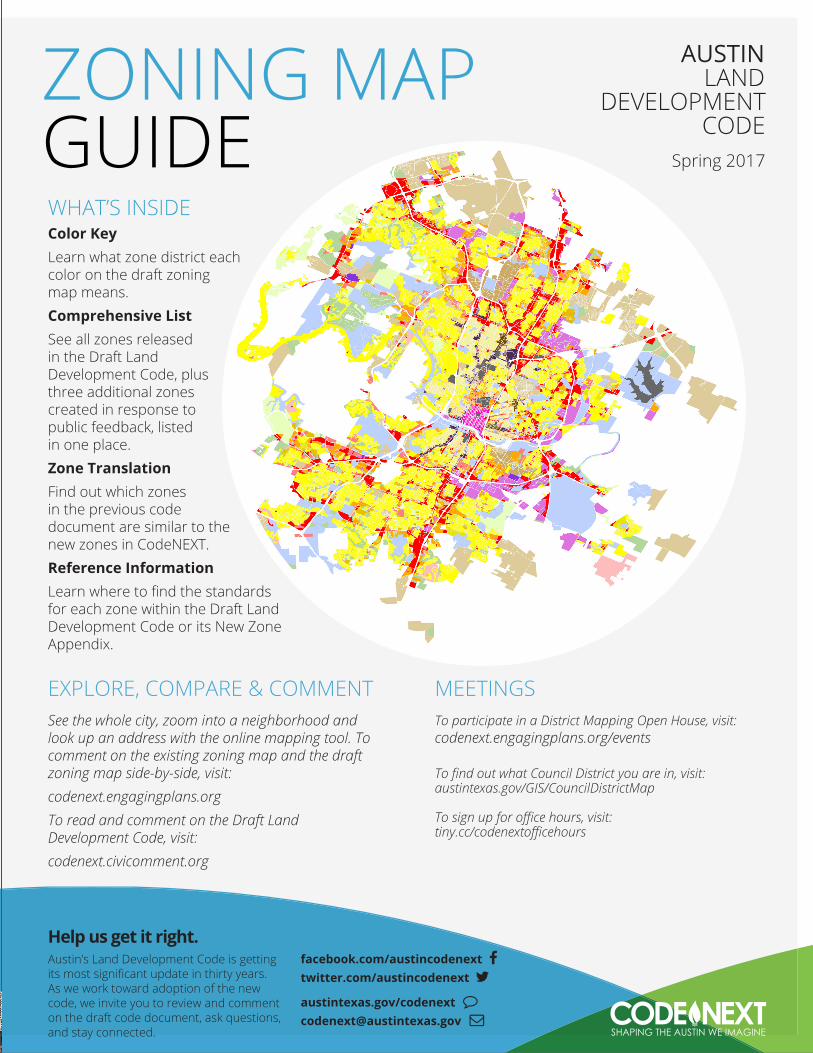
zoning map austin guide code...development code or its new zone appendix. zoning map ... to chapter...
TRANSCRIPT
MEETINGS To participate in a District Mapping Open House, visit:codenext.engagingplans.org/events
To find out what Council District you are in, visit: austintexas.gov/GIS/CouncilDistrictMap
To sign up for office hours, visit:tiny.cc/codenextofficehours
WHAT’S INSIDEColor KeyLearn what zone district each color on the draft zoning map means.Comprehensive ListSee all zones released in the Draft Land Development Code, plus three additional zones created in response to public feedback, listed in one place.Zone Translation Find out which zones in the previous code document are similar to the new zones in CodeNEXT. Reference InformationLearn where to find the standards for each zone within the Draft Land Development Code or its New Zone Appendix.
ZONING MAPGUIDE
Help us get it right.Austin’s Land Development Code is getting its most significant update in thirty years. As we work toward adoption of the new code, we invite you to review and comment on the draft code document, ask questions, and stay connected.
facebook.com/austincodenext twitter.com/austincodenext
austintexas.gov/codenext [email protected]
EXPLORE, COMPARE & COMMENTSee the whole city, zoom into a neighborhood and look up an address with the online mapping tool. To comment on the existing zoning map and the draft zoning map side-by-side, visit:codenext.engagingplans.orgTo read and comment on the Draft Land Development Code, visit:codenext.civicomment.org
AUSTIN LAND
DEVELOPMENT CODE
Spring 2017
2 | Z O N I N G M A P G U I D E
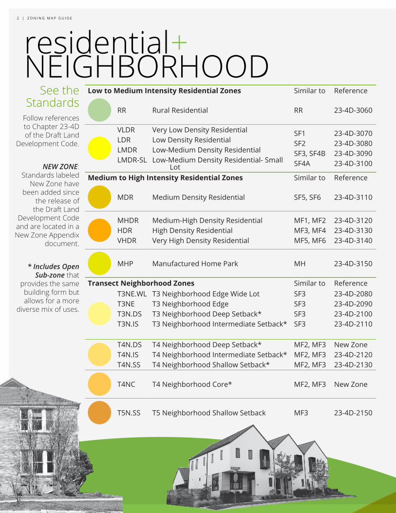
residential+NEIGHBORHOOD
Low to Medium Intensity Residential Zones Similar to Reference
RR Rural Residential RR 23-4D-3060
VLDRLDRLMDRLMDR-SL
Very Low Density ResidentialLow Density ResidentialLow-Medium Density ResidentialLow-Medium Density Residential- Small
Lot
SF1SF2SF3, SF4BSF4A
23-4D-307023-4D-308023-4D-309023-4D-3100
Medium to High Intensity Residential Zones Similar to Reference
MDR Medium Density Residential SF5, SF6 23-4D-3110
MHDRHDRVHDR
Medium-High Density ResidentialHigh Density ResidentialVery High Density Residential
MF1, MF2MF3, MF4MF5, MF6
23-4D-312023-4D-313023-4D-3140
MHP Manufactured Home Park MH 23-4D-3150
Transect Neighborhood Zones Similar to ReferenceT3NE.WLT3NET3N.DST3N.IS
T3 Neighborhood Edge Wide LotT3 Neighborhood EdgeT3 Neighborhood Deep Setback*T3 Neighborhood Intermediate Setback*
SF3SF3SF3SF3
23-4D-208023-4D-209023-4D-210023-4D-2110
T4N.DST4N.IST4N.SS
T4 Neighborhood Deep Setback*T4 Neighborhood Intermediate Setback*T4 Neighborhood Shallow Setback*
MF2, MF3MF2, MF3MF2, MF3
New Zone23-4D-212023-4D-2130
T4NC T4 Neighborhood Core* MF2, MF3 New Zone
T5N.SS T5 Neighborhood Shallow Setback MF3 23-4D-2150
Follow references to Chapter 23-4D of the Draft Land
Development Code.
NEW ZONE: Standards labeled
New Zone have been added since
the release of the Draft Land
Development Code and are located in a New Zone Appendix
document.
* Includes Open Sub-zone that
provides the same building form but allows for a more
diverse mix of uses.
See the Standards
See how the new
Land Development Codeis helping to shape the Austin we imagine.
austintexas.gov/codenext
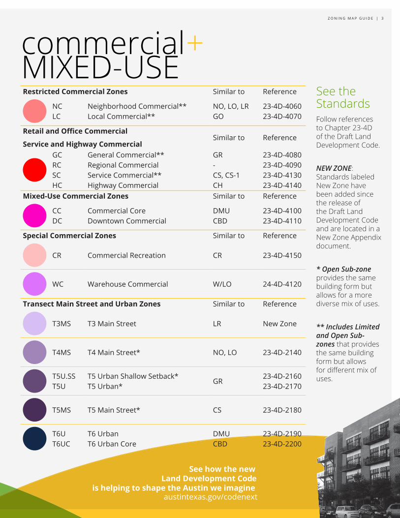
Z O N I N G M A P G U I D E | 3
commercialMIXED-USE
+Restricted Commercial Zones Similar to Reference
NCLC
Neighborhood Commercial**Local Commercial**
NO, LO, LRGO
23-4D-406023-4D-4070
Retail and Office Commercial
Service and Highway CommercialSimilar to Reference
GCRCSCHC
General Commercial**Regional CommercialService Commercial**Highway Commercial
GR-CS, CS-1CH
23-4D-408023-4D-409023-4D-413023-4D-4140
Mixed-Use Commercial Zones Similar to Reference
CCDC
Commercial CoreDowntown Commercial
DMUCBD
23-4D-410023-4D-4110
Special Commercial Zones Similar to Reference
CR Commercial Recreation CR 23-4D-4150
WC Warehouse Commercial W/LO 24-4D-4120
Transect Main Street and Urban Zones Similar to Reference
T3MS T3 Main Street LR New Zone
T4MS T4 Main Street* NO, LO 23-4D-2140
T5U.SST5U
T5 Urban Shallow Setback*T5 Urban*
GR23-4D-216023-4D-2170
T5MS T5 Main Street* CS 23-4D-2180
T6UT6UC
T6 UrbanT6 Urban Core
DMUCBD
23-4D-219023-4D-2200
Follow references to Chapter 23-4D of the Draft Land Development Code.
NEW ZONE: Standards labeled New Zone have been added since the release of the Draft Land Development Code and are located in a New Zone Appendix document.
* Open Sub-zone provides the same building form but allows for a more diverse mix of uses.
** Includes Limited and Open Sub-zones that provides the same building form but allows for different mix of uses.
See the Standards
Follow references to Chapter 23-4D of the Draft Land
Development Code.
See the Standards
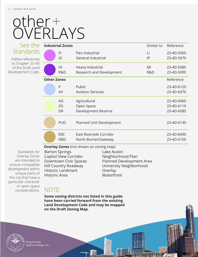
r4 | Z O N I N G M A P G U I D E
Prepared by Opticos Design, Inc.
NOTE:Some zoning districts not listed in this guide have been carried forward from the existing Land Development Code and may be mapped on the Draft Zoning Map.
Industrial Zones Similar to Reference
FIGI
Flex IndustrialGeneral Industrial
LIIP
23-4D-506023-4D-5070
HIR&D
Heavy IndustrialResearch and Development
MIR&D
23-4D-508023-4D-5090
Other Zones Reference
PAV
PublicAviation Services
23-4D-612023-4D-6070
AGOSDR
AgriculturalOpen SpaceDevelopment Reserve
23-4D-606023-4D-611023-4D-6080
PUD Planned Unit Development 23-4D-6130
ERCNBG
East Riverside CorridorNorth Burnet/Gateway
23-4D-609023-4D-6100
Overlay Zones (not shown on zoning map)
othe +OVERLAYS
Standards for Overlay Zones
are intended to ensure compatible
development within unique parts of
the city that have a particular character
or open space considerations.
Barton SpringsCapitol View CorridorDowntown Civic SpacesHill Country RoadwayHistoric LandmarkHistoric Area
Lake AustinNeighborhood PlanPlanned Development AreaUniversity Neighborhood OverlayWaterfront