younger dryas ice-marginal deposits in norway
TRANSCRIPT

Pergamon
1040--6182(95)00037-2
Quaternary International, Vol. 28, pp. 147-169, 1995 Copyright © 1995 INQUAJElsevier Science Ltd
Printed in Great Britain. All rights reserved 1040-6182/95 $29.00
Y O U N G E R D R Y A S I C E - M A R G I N A L D E P O S I T S IN N O R W A Y
BjCrn G. Andersen ,* Jan Mangerud, ' t Rolf SOrensen,:~ Arne Reite,§ Harald Sveian,§ Mor ten Thoresen§ and BjOrn Bergstr6m§
*Department of Geology, University of Oslo, P.O. Box 1047 Blindern, N-0316 Oslo, Norway tDepartment of Geology, University of Bergen, AllOgt. 41, N-5007 Bergen, Norway
~Department of Soil and Water Sciences, Agricultural University of Norway, P.O. Box 5028, N-1432 As, Norway §Norwegian Geological Survey, P.O. Box 3006 Lade, N-7002 Trondheim, Norway
INTRODUCTION
Distinctive Younger Dryas (Y.D.) marginal moraines fie within a narrow morainal belt, which has been traced and mapped from the Russian border in the north through the fjord districts of northern, western and southern Norway to the Swedish border in the south, a distance of approximately 2500 km (Fig. 1 in Andersen et al., this volume). One ridge or two semi-parallel main ridges together with scattered ice-front deltas are most common, but in some areas there are many smaller ridges within the belt. In most areas the main Y.D. moraines represent the largest and most distinctive ice-marginal deposits.
The Y.D. ice fronts pushed into marine environment in the fjord districts, and marine sediments were deposited at, and beyond, the ice fronts. This kind of sediments frequently contain marine molluscs that have been radiocarbon dated, and used to date the Y.D. sediments, as indicated by Andersen et al. (in this volume). In the order of 200 radiocarbon dates of molluscs related to Y.D. have been obtained. They were corrected for a marine reservoir age as indicated by Andersen et al. (in this volume), who also described the procedure by which the dates are presented in the following.
The Y.D. glaciers reached a maximum extent in early Y.D. time in most areas, except in districts near Bergen in western Norway (Fig. 1) where a late Y.D. advance was most extensive. Marginal moraines and ice-front deltas deposited during late Y.D. advances have been recorded in several areas. They frequently lie from 10 to 40 km behind the main early Y.D. ice-marginal deposits.
Glacially tectonized, or glacially overridden AllerCd deposits have been found in several areas on the proximal side of the Y.D. moraines. They show that the Y.D. glaciers advanced from a few to more than 40 km in various areas. The ice fronts retreated rapidly both before and after the main Y.D. phase.
A considerable lowering of the equilibrium line took place in Y.D. time, and numerous Y.D. local moraines were deposited by cirque glaciers or small local ice caps
in coastal areas beyond the main Y.D. morainal belt. The corresponding glaciation limits and equilibrium lines lay between 350 and 600 m below those of present day in various parts along the coast.
Both the lowering of the equilibrium lines and the changes in marine fauna and in pollen flora show that the Y.D. climate was drastically different from the climates before and after this phase. Even the distinctive Y.D. shoreline, which is called the Main shoreline in north Norway, is probably an indication of cold climate, since the line consists of well-developed terraces eroded in bedrock in many areas.
The following regional descriptions start with regions in northern Norway and continue through western and southern Norway. Some key names are shown in Fig. 1, and other names are presented on local maps.
NORTH NORWAY (BY B.G. ANDERSEN) NORDLAND, TROMS AND FINNMARK (FIG. 1)
General Description Conspicuous marginal moraines of Younger Dryas
(Y.D.) age have been mapped in the fjord and coastal districts of North Norway, from TrCndelag through Nordland (Andersen, 1975; Rasmussen, 1981; and Andersen et al., 1982), Troms (Andersen, 1968) 1973). The main moraines lie within a morainal belt, which can be traced almost continuously from Tr~ndelag to the Russian border, a distance of approximately 1200 km, and the moraines continue across the border into Russia. (See Rainio et al., in this volume.) The Y.D. moraines are usually the largest and best developed marginal moraines in every fjord district. In Troms and Finnmark, they represent the Troms¢-Lyngen event, and in Nordland, the Tj6tta event. Several parallel ridges frequently lie within the morainal belt, most commonly two, but in some areas more, and in other areas only one. Where the Y.D. moraines cross the fjords there are usually large, marked submarine ridges (Fig. 2), and morainal points
147

148 B.G. Andersen et al.
rROMSA¢ - ,:-- "), / f~CTromso ) "'
TRSNDELAG,,O ' ,
"Q _ ~ _ _ ron ; l l~ f jo rd 640 J ~Trondheim
WE~.r~o~/~.Nordfjord . . . . . ~.ognef jord '",
NO~Wer2~Y ~ " H ard an, er ',; TCrgo d - , , ,, 600
RYFYLKE ~t~Lvse- . ~ " ~ ,
S~RLANDET
FIG. 1. Names of some districts described in the text.
on both sides (Fig. 3). Laternal moraine ridges lie along the fjord sides (Fig. 4), except where it is too steep, and they are used to reconstruct the longitudinal profiles of the glaciers (Fig. 5). Most profiles show that the frontal parts of the fjord glaciers were steep, and that, together with the sharp, steep-sided moraine ridges, which are most likely push moraines, indicate that the glaciers
SW NE
1 M
2OO
- S O ;
, + + + ÷ + 4 ÷ + + + + + + + + * ÷ 4 4 ÷ ÷ ÷ + + 4 4 + ÷ + 4 ÷ + ÷ 4 ÷ 4 ÷ ÷ ÷ ÷ ÷ + 4 ÷ 4 ÷ 4 4 4 + 4 ÷ ~ ÷ ÷ 4 ÷ 4 ÷ 4 4 ÷ ~ ÷ ÷ ÷ 4 4 4 4 ÷ 4 + + + 4 ÷ ÷ ÷ 4 + + + ÷ 4 ÷ 4 + ÷ ÷ + + + ÷ ÷ + ÷ 4 ÷ ÷ + + 4 ÷ 4 + ÷ ÷ + 4 4 ~ + 4 ÷ ÷ 4 4 + + + 4 4 . ÷ 4 . ÷ ÷ + ÷ ÷ ÷ ÷ ÷ ÷ ÷ ÷ ÷ 0 ÷ ÷ ÷ ÷ 4 4 4 ÷ ÷ o ÷ ~ ÷ 4 + ÷ o ÷ ÷ 0 ÷ 4 ÷ 4 4 ~ 4 ÷ 4 4 4 4 4 4 ÷ ÷ o * ÷ 4 4 * ÷ ÷ ÷ * . 4 ÷ 4 ÷ ÷ ÷ ÷ ÷ ÷ + ÷ 4 + ÷ ÷ ÷ 4 ÷ ÷ ~ ÷ ÷ 4 ÷ ÷ ~ 0 ÷ 4 4 4 ~ ÷ 4 ~ * * o . 4 ÷ ~ 4 ÷ + 1 ÷ 4 4 + + 4 4 4 4 + + + + 4 ÷ + 4 ~ ÷ ÷ + + + + + ÷ + ÷ 4 ÷ ~ 4 4 4 4 + ~ + ÷ 4 ÷ + ÷ 4 + 4 ÷ ÷ 4 + + ~ + 4 ÷ + + ÷ + + ÷ + ÷ ÷ 4 ÷ ÷ 4 4 + ÷ ÷ 4 4 4 4 ÷ ÷ 4 4 ÷ ÷ ÷ 4 + ÷ ÷ 4 ÷ ÷ * ÷ . 4 + 4 ÷ 4 ~ * ÷ ÷ +
[ ] c** 1:2:] ~" [ ] s.~ PTl ~. . , [ ] r., ( i ] ~ .
FIG. 2. Cross-section of the submarine Younger Dryas (Y.D.) end-moraine ridge which crosses the mouth of Ranafjord (see Fig. 7). The lines represent reflectors recorded on a sparker
profile. From Andersen et al. (1982).
were very active. Where the ascending lateral moraines reach the level of the adjacent mountain plateau, the morainal belt continues across the plateau to the next fjord. On the extensive plateaus of eastern Finnmark, there are commonly many ridges within a wide belt.
The distinctive Main shoreline corresponds with the Y.D. morainal belt (Figs 3 and 6), and this, in combination with radiocarbon dates of the moraines, has been used to verify the Y.D. age of the observed morainal belts in the different fjord districts.
Within the fjords of Nordland, there are Y.D. moraines representing the so-called Nordli event approxi- mately 30 km east of the well-defined main Y.D.
FIG. 3. The Troms0-Lyngen (Y.D.) end moraine crosses the mouth of S÷rfjord, a branch of Ullsfjord (Fig. 4) looking north. Note the steep lateral moraine (L) in the right foreground, and the distinctive Main shoreline in the background, marked with an arrow. Photo
by Royal Norwegian Airforce.

Ice-marginal Deposits in Norway 149
T j q J
'. ' ' % ./ f ' "
• '..? ; j. .. ,n....!
j 'lj,.ane~ V . ~ @ '~ ¢
IISm A ,i ~qB
- - e 4~ e'" ~e,e
J ~
I f t
.~..F.. "11
o . ' ° " ~
e l Qw
p ~ °
%',°. °~ i " ....
69
10 km ! J I
FIG. 4. Marginal moraines within the Troms~ area of Troms. Heavy black lines: Younger Dryas (Y.D.) moraines, xxxx-lines: older and younger moraines. Short curved lines: Y.D. local moraines.
m
800
700
600
500
400
300
200
100
SerrjoTd ,- U l l s l i
.o°- . . .
Ba is f j
2'0 3() km
FIG. 5. Longitudinal profiles of Younger Dryas glaciers in Balsfjord and Scrfjord (UIIsfjord). Modified from Andersen (1968).

150 B.G. Andersen et ul.
FIG. 6. The Younger Dryas (Y.D.) shoreline in an area near the Y.D. marginal moraine in southern Nordland is frequently represented by terraces eroded in bedrock. Photo by A. Rasmussen.
moraines (Fig. 7). They have been dated at approxi- mately 10.1 ka BP (Fig. 8)
Radiocarbon Dates of the Moraines In the order of 40 radiocarbon dates have been
presented of deposits related to the end moraines in North Norway, most of them by Andersen (1968, 1975), Rasmussen (1981), Andersen et al. (1982), Marthinussen (1962) and Corner (unpublished data). All dates, except three, are of marine shells. The shells were usually collected from sediments within, or adjacent to the end moraines, or corresponding ice- front outwash deltas. All dates presented by Andersen (1968, 1975) represent some of the first dates of marginal moraines in Norway, and some of them have relatively high values for the standard deviation, which suggests that they are not very accurate. For this reason, and because of problems with exact correlation of some of the dated deposits with early or late phases of the end-moraine formation, the presented time limits for the glacial phases (Fig. 9) must be considered tentative. However, the many good dates of the Tj6tta Substage moraines in Nordland, and of the TromsO-Lyngen Substage moraines in Troms and Finnmark, clearly show that they are of Y.D. age.
Stratigraphic observations together with the fact that there are frequently two parallel main moraine ridges within the Y.D. morainal belt suggest that this belt may represent two separate glacial phases: in Nordland an early phase 10.9(11.2)-10.8 ka BP, and a late phase 10.6-10.5 (10.4) ka BP; in Troms an early phase 11.3(?)-11 ka BP, and a late phase 10.5-10.3 ka BP (see Figs 8 and 9).
The Advance before and the Retreat after the Main Younger Dryas Phase
Since most of the dates are of sediments connected with the moraines, and very few are of deposits in areas between the moraines, the exact patterns for the retreat and advance phases are not known. We know that the retreat following an approximate 12.2 ka old Skarpnes event (Fig. 7) was rapid, at least 12 km in approximately 300 years, and by approximately 11.9 ka the ice front was located proximally to the location of the Y.D. end moraine in Balsfjord. We also know that the Aller0d period was relatively warm, with a Boreo-Arctic marine fauna. Therefore, there is good reason to believe that the ice front had retreated a considerable distance behind the Y.D. end moraine before it started the Y.D. advance. An approximate 11.5 ka date of shells from a glacially overridden deposit about 800 m proximally to the Y.D. moraine in Ullsfjord supports this conclusion (Corner, pers. comm.). Dates from Nordland, too, suggest that the ice front had retreated to a position near, or proximally to the position of the Y.D. main moraines at the beginning of the Aller0d period (Figs 8 and 9).
The dates of younger end moraines, which lie a considerable distance behind the Y.D. moraines, show that the retreat following the Y.D. main phase was rapid (see Figs 7 and 8).
The Younger Dryas Shoreline The most distinctive shoreline in north Norway is
the Main shoreline, which is frequently carved into bedrock and forms bedrock terraces (Figs 3-6 and 10). This shoreline is of Y.D. age, and it is usually best

Ice-marginal Deposits in Norway 151
~o*o
,66*30 '
-66"15'
46*
¢ .
I |
i
** ° . °°
°°
°," °°*
• ::~.....
****°
*.
10 km k
FIG. 7. Marginal moraines (heavy lines) recorded in southern part of Nordland. The Tj6tta moraines represent the main Younger Dryas moraines. Modified from Andersen et al. (1982).
~4C atte 0m~) IF
10
NORDLAND
"C dmte of delmslt: o~ • older tkan Use mor-;ne X corrapondin| with tire morMme r . ~ m t ~ t o l c ~ 9 ~ h o younger than the morelue _ _ m.?
oJ~-"~. I Naniknl 9.6± O.2 .
. . - _ _ _*f~'~'~ywo~'DL7 " ~ ' r i c n , . 2 - 1 o . , , .
m . - - - - ~ - * m - - - - - "- -~ i ' 0 . 4 Im "110..5 u
~ , ~ [ ~ ~ TJI~TTA SUIISTAGE
• . vq,, 12.2 Jut (?! i i I I J
FIG. 8. Time-distance diagram for ice-front fluctuations in Nordland.

152 13. G. Andersen et al.
14C age
( h i t )
9"
1(
11
12
20 I J0
TROMS and waternmmt FINNMARK
t4C date of depmlt:
• older than the moraine
x corre~ponding wlta the moroine q~..--"~M~en~. ' 9.Sko
o younger than the moraine ~,
_ ~ . B ~ r e , ~ , 9.9 ka
~ .3 kn
¢~7~~ ~.l k.
6 70 20 30 ~0 ~e ' t~ ' h kal
FIG. 9. Time-distance diagram for ice-front fluctuations in Troms and westernmost Finnmark.
developed immediately in front of the Y.D. moraines. In addition, the outwash deltas which correspond with Y.D. moraines were graded to the Main shore level. The late glacial shorelines within the fjord districts proximally from the Y.D. moraines are generally indistinct, and lie at lower shore levels.
The Younger Dryas Marine Fauna A high-Arctic Portandia arctica fauna dominated by
P. a., Macoma calcarea and Hiatella arctica frequently occurs in clays deposited near the Y.D. ice front. The same fauna was also found in some older clays, but a Bathyarca glacialis fauna dominates in Y.D. glaciomarine clays deposited after the main Y.D. moraines, such as in clays deposited at the approximately 10.1 ka old Nordli moraines. A Boreo- Arctic fauna with thick-shelled specimens of Mya truncata, Chlamys islandica, Astarte elliptica, and so on dominates in most Aller~d sediments which were deposited at some distance from the muddy water near the ice fronts, and the same kind of fauna is found frequently in Preboreal sediments.
The Younger Dryas Local Glaciers and Glaciation Limits Numerous small, distinctive moraines deposited by
local glaciers lie in the mountains beyond the Y.D. morainal belt, and no corresponding moraines exist in areas on the proximal side of this belt (Figs 4 and 10). Therefore the moraines are of Y.D. age or older. Since many of the local moraines lie in areas immediately outside the Y.D. belt, which are areas that were covered by the approximately 12.2 ka old Skarpnes fjord glaciers, they must be younger than 12.2 ka BP. Some of the local glaciers deposited end moraines in the shore zone, and particularly one
of the moraines has a well-defined outwash delta at Main shore level (Fig. 10). At another locality, an approximately 10.5 ka old marine bed in front of a local moraine, was correlated with the moraine. Therefore, all considered, most of the local moraines must be of Y.D. age. Based on the location of the numerous Y.D. local moraines and the altitudes of the glaciated mountains, Andersen (1968, 1975) calculated a Y.D. glaciation limit and equilibrium line at approximately 475 + 50 and 550 + 50 m below present day glaciation limit/equilibrium line in Troms and Nordland, respectively.
T R O N D E L A G (BY A. REITE, H. SVEIAN, M. T H O R S S E N AND B.G. ANDERSEN)
The districts adjacent to the extensive Trondheimsfjord have been studied by many Quaternary scientists, and the following presentation is based on numerous publications and reports, such as Reite (1994), Reite et al. (1982), Sveian (in preparation), and Sollid et al. (1976, 1979), in addition to unpublished information from several scientists at the Norwegian Geological Survey (NGU).
General Descriptions The Trondheimsfjord is a wide fjord consisting of
several overdeepened rock basins partly filled with thick units of glaciomarine sediments. It is surrounded by low-lying districts which are frequently covered with glaciomarine deposits. The sea level was in the order of 150-200 m higher than today when the ice front was located within the fjord area. Wide valleys lead from the fjord eastward through a low mountain range at the Swedish-Norwegian border. Ice from the

Ice-marginal Deposits in Norway 153
O
~z
.=. =
~=.=
~,z-
~.<
~5 r,

154 B . G . Andersen et a/.
f " . . o . .
........-, .... ( ..¢
~ o.
°o
VUKU I
I.ON-. ~.llOq
|
?
". . . -
N
T 30 km
FIG. 11. Marginal moraines in the Trondheimsfjord area of Central Norway. The Tautra moraines represent the main Younger Dryas (Y.D,) phase and the Hoklingen moraines represent a late Y.D.
phase, Modified from Reite (1994).
central parts of the Scandinavian ice sheet could easily cross this mountain range, and it pushed into the Trondheimsfjord area with a long fairly straight-lined ice front. It crossed this fjord during the first half of the Younger Dryas (Y.D.) period, with an extensive calving front at Tautra, and it deposited a marked end moraine on the Fosen Peninsula (Fig. 11). Only on the south side of the Trondheimsfjord do deeper valleys lead into higher mountains and mountain plateaus from which valley glaciers entered the fjord district.
The coastal areas to the west of the fjord were deglaciated between 13,000 and 12,000 years ago, and four more or less parallel main morainal belts have been mapped in areas from the coastline to the districts near the Swedish border (Fig. 11). However, detailed mapping carried out by Sveian (in preparation) in the northern part of Tr0ndelag indicate that there are many ice-marginal deposits located between the main moraines. Their location is generally controlled by topographic features rather than climatic events, and the ice recession was usually rapid between the main morainal belts.
The belt, which represents the Tautra Substage, is by far the most dominant, and can be traced as an almost continuous belt over considerable distances, except within the southern mountain districts. The Tautra moraines are of early Y.D. age, and there is another almost continuous morainal belt representing a late Y.D. event, the Hoklingen Substage, approximately 10-30 km behind the Tautra moraines. Parts of the end moraines were deposited in marine environment, and they are frequently composed of both till beds, glaciomarine and glaciofluvial beds. Narrow end- moraine ridges, often 8-10 m high, are commonly found on higher terrain.
The Age of the Younger Dryas Moraines Fossiliferous glaciomarine beds lie both below, within
and on top of some of the observed end moraines. In addition thick fossiliferous glaciomarine beds, in general clay beds, lie on the distal side of the moraines. Most of the dates related to the moraines are radiocarbon dates of marine shells from this kind of deposits. However, some few dates are of organic lacustrine deposits and of whale bones. The Tautra moraines are, in fact, most accurately dated by means of whalebones, and gyttja from below and on top of a laminated lacustrine unit deposited in a lake which was dammed by the Tautra Substage glaciers.
Figure 12 is a time-distance diagram for ice-front fluctuations based on dates from the southern parts of Tr0ndelag. The diagram is modified from Reite et al. (1982) and Reite (1994). Based on the dates, they suggested an age between 10.8 and 10.5 ka BP for the Tautra morainal belt. This time bracket again relies very much on the mentioned two dates of gyttja above and below the laminated Y.D. unit. However, if only dates of fossils from the marine deposits are considered, the oldest age limit for the Tautra moraines could as well be approximately 11 ka BP. Keep in mind that all dates of marine fossils are corrected for a reservoir age of 410 or 440 years, and with a somewhat higher reservoir age for the fossils (see Andersen et al. in this volume) the correct radiocarbon age for the lower limit of the Tautra event could very well be approximately 10.8 ka, even based on dates of marine fossils.
Numerous dates of marine shells from till beds and end moraines in the northern part of Tr0ndelag were presented by Bergstrfm, Olsen and Sveian (Bargel et al., 1994). However, no time--distance diagram was presented, and the exact correlation with the moraines is problematic in some cases. Therefore, only the plotted dates and the location of the moraines are shown in Fig. 13. The authors concluded that the dates support an age of 10.8-10.5 ka BP for the Tautra morainal belt, and they dated an older belt of coastal moraines at approximately 12.4--12.3 ka BP. This coastal belt, which we tentatively call the 'Outer Coastal Moraines', approaches the Tautra moraines in the northernmost part, and many dates of marine beds below Tautra age sediments range between 11 and 12.5 ka BP in that area. This indicates that the

Ice-marginal Deposits in Norway 155
J4c at, i n u.) ~ G
10 ¸
a O - - - - - ~- '? (10.4-10.3kltl
~ A U T R A SUBSTAG, II0.S-10Jktl
O
M, JdOItAINIIS (!1.4-12.3k8)
" I ! I L , , • , ~o b 4o x n le ~i. t~J x, ~ ~o ~o 6, .~,--
FIG. 12. Time-distance diagram for ice-front fluctuations in the Trondheimsfjord area. Modified from Reite et ai. (1982) and Reite (1994). (a) Dates of lacustrine gyttja, (b) dates of whale bone. Legend: see Fig. 9.
ice front there was located at or behind the position of the Tautra moraines as early as in Btlling time.
The Hoklingen morainal belt is located from 10 to 30 km behind the Tautra belt. The available radiocarbon dates of marine fossils suggest that the Hoklingen moraines are of late Y.D. age, about 10.3-10.4 ka old, and marine sediments proximally to the moraines are dated at 10.2-10.3 kaand 10 ka BP (Sveian, 1989).
The Vuku morainal belt lies approximately 20 km east of the Hoklingen moraines. The moraines are
.65 e
I . - - o_ I
I I
I .... I
FIG. 13. Radiocarbon dates of molluscs, mostly from tills and ice-marginal moraines or glaciofluvial deltas, and a few from glaciomarine clays in northern Tr~ndelag. (Compiled by Bergstr6m,
Olsen and Sveian, in Bargel et al. , 1994.)
relatively small, and they are dated at about 10-9.8 ka BP. A few more prominent moraines, representing a Grong- Sn~sa event, lie 30--40 km behind the Vuku moraines at Sn&sa, and the suggested age is 9.8-9.5 ka BP.
The Younger Dryas Advance Marine AllerCd deposits below basal till that was
correlated with the Tautra end moraines have been observed a considerable distance behind the Tautra morainal belt, approximately 15 km at one locality and possibly 35 km at another. As mentioned before, the ice front had retreated to the position of the Tautra moraines as early as in mid-Btlling time within the northern parts of TrCndelag. Therefore the retreat behind the position of the Tautra moraines was most likely a combined Btlling-Allertad retreat, and the advance to the Tautra moraines was a late Aller~d(?) early Y.D. advance.
WESTERN NORWAY (BY J, MANGERUD)
A synthesis of the palaeoenvironmental and palaeo- climatic changes in western Norway during the AllerCd- Younger Dryas (Y.D.)-Early Holocene is presented recently by Birks et al. (1994). A short review of glacier fluctuations is also given by Nesje and Dahl (1993). The present paper is focused on the identification and age of the Y.D. end moraines.
The Area between Hardangerfjord and Sognefjord
Identification of the Younger Dryas Moraines In this area, the Y.D. moraines were not properly
identified and mapped until the 1970s (Mangerud, 1970; Aarseth and Mangerud, 1974). The reason is simply that most of the end moraines on land are very small, 1-5 m high, and discontinuous.
Two new techniques were crucial for solving the problem:
(1) Mapping the sub-marine moraines with penetrating echo-sounder, which enabled Aarseth and Mangernd (1974) to connect the terrestrial moraines with moraines

156 B . G . Andersen et al.
84"-
6"
:" [
8"
o
i ( , i
11070~180,~ 10940±180[~
"Z.
Z 0
~>
10230~180 i 1 2 2 2 0 ± 1 5 0 i
N
0 5 10km k J -.,,..J
,~Se °
0@@@@@@
End moraines !
Ice-front deposits without constructional HERDLA morphology MORAINES
Assumed position of ice-front
Radiocarbon dates from till and sub-tilt sediments. Locality marked by cross
10260¢120 Dates from sediments not disturbed by ice
==
10260i120 / 10940±180 / 11265±100 /
FIG. 14. Map of the coastal area between Hardangerf jorden and Sognefjorden. The Younger Dryas (Y.D.) Herdla moraines are indicated. Radiocarbon dates in boxes are from shells in till or in sub-till sediments, which give a min imum measure of how far east the ice front withdrew during the AUerod, and also prove a glacial re-advance subsequent to the given ages. Dates that are not in boxes (Blomcy, Agotnes , Vinnes) show sites with an undisturbed AllerCd-Y.D. sequence, which demonstra te that the Y.D. re-advance did not overrun these sites. On the inset map is shown the Y.D. moraines around southern Norway; from Aarseth and Mangerud (1974), with some additional dates. In order to give identical numbers to Fig. 2, all dates on marine fossils are corrected for a marine reservoir age of
440 years (whereas in the original they were corrected for 410 years).

Ice-marginal Deposits in Norway 157
=!
~ 3 N N I A . . . . -: ~ . , ~ , = . ~ _ ~ . , ~ . ~ _ = . ~ . . . .
k'~ ~t'~'~Tv~ - - -- '(~'- '- j~'~N'~'TT I , ~ 9 "1 ~;~9 -1 C ~ 9 - 1 09t~0t'£ 6 081~0t'6 0I 061~0Z0 It ~z9-1 08t;OZO ~t
+, +, +p ÷, ÷= +~ +, 0 0 O 0
4 E - o 9® = m
I I i I I I I I I I I I ~ I I I I
g 0
0 0 0
o ~
, , , , i I , 1 , 1 , , , 0 0 0
I I I l I
0 0
i;
0 0
=.~
E ~

158 B.O. Andersen et al.
across the numerous fjords and sounds. In fact, the moraines are often larger on the fjord bottoms, which were the valley floors, compared to the land areas. In this way a nearly continuous end moraine zone, named the Herdla Moraine, was mapped.
(2) Radiocarbon dating. In the Bergen area tills with shells or shell fragments had been known from the turn of the century. However, the ages of the shells were unknown until the first radiocarbon dates yielded AllerOd and Y.D. ages (UndAs, 1963; Holtedahl, 1964), demonstrating that the Y.D. glacier re-advanced across that area. Sub.sequenfly similar dates were obtained from many different sites (Fig. 15) (Mangerud, 1970; Aarseth and Mangerud, 1974; Mangerud et al., 1979; Mangerud, unpublished data). The crucial observation is that all sites yielding ages in the range 10-12 ka BP of shelly tills or sub-till sediments are situated east of (proximal to) the Herdla moraine. Shortly west of the Herdia moraine undisturbed stratigraphic sequences were discovered (particularly Blomcy, Agotnes, Vinnes, Figs 14 and 15), covering the entire period from 12,000-9000 (Mangerud, 1970, 1977; Ovstedal and Aarseth, 1975), proving that the Y.D. re-advance did not extend beyond the Herdla moraine. In this area only one end moraine zone of Y.D. age is found, and it was formed very late in Y.D. (Fig. 15).
The correlation of the Herdla moraine across Hardangerfjord was established by Follestad (1972) and Holtedahl (1975). Along the southern side of Hardangertjord Follestad (1972) mapped lateral moraines which demonstrated that the Y.D. glacier indeed was very thick (Fig. 16).
Age and amplitude of the Younger Dryas re-advance All radiocarbon dates from Y.D. till or sub-till
sediments are of marine shells. They are corrected for a reservoir age of 440 years, whereas the Y.D. reservoir age probably is 700-800 years (Andersen et al., this volume). The dates demonstrate that the ice withdrew far inland during the AllerCd (Figs 14 and 15). The time for the start of the Y.D. re-advance is not precisely known, except that it post-dates the age 11,23-11,53 ka BP of the site (Trengereid) which lies farthest inland (Fig. 14). The re-advance ended shortly before 10 ka BP when the ice front reached the Herdia moraine. How fast the ice front advanced between these two end points cannot be determined in detail. The simplest assumption is that the glacier advanced more or less continuously during the entire Y.D., especially when considering the ampfitude of the re-advance in the deep fjords (see below). This conclusion is also supported by the interpretation of
nULLI. W E m.u.I.
:1 m.a.Ll, m.uJ. lr~O- NE -1500
1000
GO0-
-5OO-
SW Q
~tve 11 .2~180
-1000
-5OO
-5OO
FIG. 16. Longitudinal profiles along fjords where the glacier re-advanced during the Younger Dryas (Y.D.) The upper profile is Herdlefjorden-Scrfjorden (the short fjord connecting the two fjords is omitted), see Fig. 2. The easternmost site (Trengereid) with Aller#d dates is marked. The glacier profile is from Hamborg and Mangerud (1981). Note that the fjord along most of the distance of the Y.D. re:advance is 300-500 m deep. The lower profile is Hardangerfjorden, simplified from Follestad (1972). The glacier surface is mapped by means of lateral moraines. The innermost proven AllerOd site (~lve) in this fjord is also marked, but the ice probably withdrew considerably farther inland. The fjord is around 10 km wide along this profile, and as shown, more than 500 m deep along
long stretches.

Ice-marginal Deposits in Norway 159
the marine sequence at Vinnes, just outside the Herdla moraine (Aarseth 1994 pers. commun.). However, the envelope of dates also allows for a fast first re- advance to the vicinity of the Herdla moraine around 10.8 ka BP, followed by a minor withdrawal, and a second re-advance near the end of Y.D. (Fig. 15), as proposed by Anundsen (1985).
The minimum extent t~f the re-advance is some 40-50 km, measured from Trengereid to the Herdla moraine. However, a diverse AllerOd mollusc fauna with nine species, including Clamys islandica and even Modiolus modiolus found at Trengereid, indicates that the ice front was much farther inland when that fauna lived there.
Even more important in judging the amplitude of the Y.D. re-advance is the location of the lateral moraines, which demonstrates that the glacier front was steep and the glacier was thick (Follestad, 1972, Aarseth and Mangerud, 1974). In addition, the re-advance occurred in several hundred meter deep fjords (Fig. 16). Thus along most of the profiles shown in Fig. 16, the ice was more than 800-1000 m thick in areas that were ice free before the re-advance. Mangerud (1980) interpreted the large re-advance in this area, compared to, for example, more easterly areas of Scandinavia, as partly a result of accumulation of snow on extensive mountain plateaux dose to the coast, which could feed ice flow down narrow valleys and fjords.
The Area North of Sognefjord South of Sognefjorden the main ice sheet nearly
reached the outer coast during the Y.D. glacial maximum, and no local glaciers existed beyond the ice sheet. This pattern changes completely north of Sognefjorden where the marginal moraines deposited by the main ice sheet continue inland; in Nordfjord they occur in the middle part of the fjord, and in Storfjord and Romsdalsfjord close to the head of the main fjords. North of Sognefjord numerous cirque glaciers, and even an ice-cap (/ldfotbreen), existed in the mountains west of the main ice sheet during the Y.D.
Moraines deposited by the Scandinavian ice sheet Fareth (1987) mapped the Y.D. moraines, the Nor
moraines, in Nordfjord, where large frontal deposits occur across the main fjords and valleys, and long segments of laternal moraines lie along the valley slopes. This allowed him to reconstruct in detail an extensive system of long and thick outlet glaciers from the ice sheet. Fareth dated the Nor moraines to approximately 10,440 + 170 BP (T-645), using molluscs in glaeiomarine clay in the distal part of an ice-front delta (Fig. 17). Mangerud et al. (1979) obtained a slightly older age (10,750 + 170, T-2304) on shells in till distal to the Nor moraines, and stratigraphically below the mentioned glaciomarine clay. This demonstrated that in this area there had indeed been a re-advance that culminated early during the Y.D., and that the glacier during this early re- advance had reached beyond the main (Nor) moraines
(Fig. 17). Klakegg and Nordahl-Olsen (1985) obtained more dates (plotted on Fig. 17) confirming these conclusions. As important was their discovery of shells in till some 30 km proximal of the Y.D. moraines from which were dated at 11,360 + 70 BP (T-6091) (Fig. 17). Thus the Y.D. re-advance (e.g. across the 514 m deep lake Hornindalsvatnet) had been of the same order of magnitude as in the Bergen area, but in the Nordfjord area it culminated early during the Y.D. Rye et al. (1987) obtained dates that showed that the glacial retreat after the Y.D. was fast.
North of Nordfjord Sollid and SCrbel (1977, 1979) mapped the marginal moraines deposited by the Y.D. ice sheet close to the head of Storfjorden and Romsdalsfjorden. They also reported lateral moraines as high as 1450 m a.s.l. In that area no radiocarbon dates related to the moraines are reported.
Local glaciers Cirque glacier moraines were first described in the
coastal mountains of this area by Kaldhol (1930). Reite (1968) obtained a radiocarbon date, which demonstrated that the ice sheet withdrew from the area near the cirque moraines during the AllerCd, and he argued that the large depression of the equilibrium line shown by the cirque moraines indicated that they were of Y.D. age. This age was finally confirmed for a cirque moraine at Kr~kenes (Fig. 14) by means of coring and dating sediments in a lake downstream of the moraine (Mangerud et al., 1979; Larsen et al., 1984). In the lake they found organic sediments which demonstrated that this particular cirque glacier did not exist during the AllerCd (between 12,320 + 120, T-2534 and 11,100 + 80, T-2532), but overlying laminated clay showed that it was formed at the onset of the Y.D. and disappeared near the transition to the Holocene. The Vedde Ash was found in the middle of the laminated unit (Mangerud et al., 1984). This ash was originally dated to 10.6 ka BP, but AMS dates of terrestrial macro plant remains gave an age around 10.3-10.4 ka BP (Bard et al., 1994; Mangerud et al., unpublished data from Kr~kenes). This type of investigations has been continued by S~nstegaard and co-workers who have cored many lakes downstream from local glaciers. They have not found any other site where they could prove that the cirque glacier disappeared completely during the Aller~d, and their preliminary conclusion was that most local glaciers survived during the AllerCd, although they were smaller than during the Y.D. (S¢nstegaard, 1994, pers. commun.) The glacier at Kr~kenes was situated at lower altitude than most of the other Y.D. cirque glaciers (Larsen et al., 1984). Therefore this glacier was more sensitive to climatic fluctuations, and it disappeared during the climatic amelioration of Aller~d, which glaciers at higher altitudes survived.
A large number of Y.D. moraines deposited by cirque glaciers have been mapped between Sognefjorden and Romsdalsfjorden (e.g. Fareth, 1987; Sollid and SCrbel, 1979; Larsen et al., 1984). They are generally

160 B ( , . A n d e r s e n et al.
o ~
t~UlOJOUJ ~I) uoloP.L3 e
0
l
~.~ 0
~UIDJOW
SaU!OJOW ~I~A JSU!A 0
8,,=,
sauioJow~ JO N b~V~l ~
i ~ 5no4ap~oA o" sau!oJOW
I \ \
sauioJOUJ )I!AO(~ ~-~
o¢ au,oJow polsaa-I
: 0
o
8 o
8 o
8 0
• • •
~5
o o 0
~o
0
~o
e,
Z ~
r~ 6

Ice-marginal Deposits in Norway 161
well defined, 2-10 m high ridges, curving across the mouth of cirques or across valleys. Also some larger individual glaciers existed during the Y.D. The largest was an ice cap on the plateau where present day Alfotbreen (glacier) is located (Fareth, 1987; Klagegg et al., 1989). This glacier reached its Y.D. maximum before the 10.3-10.4 ka old Vedde Ash was deposited (S4anstegaard, 1994, pers. commun. ).
Equilibrium line depressions The problems related to the calculation of palaeo-
equilibrium line altitudes and comparing them with the present day situation were recently discussed by Dahl and Nesje (1992). Here we will mainly list some results. The largest depression of the Y.D. equilibrium line altitude (ELA) was along the outermost coast, where Larsen et ai. (1984), for 14 cirque glaciers, calculated a mean lowering of 600 m compared with the present day (extrapolated) steady-state ELA given by Ostrem and Liest~l (1964). (Note that Larsen et al. added 100 m and cited 700 m depression compared with the climatic ELA for 1931-1960.) Fareth (1987) found a depression of ELA of approximately 450 m for Y.D. valley glaciers in the middle and inner parts of the Nordfjord, and slightly less for some local glaciers, when comparing with Ostrem and Liestals map. Dahl and Nesje (1992), and Nesje and Dahl (1992) found similar values, using the same method as Fareth. However, Dahl and Nesje (1992) found that the ELA depression for one particular Y.D. cirque glacier was only about 170 m if they compared with ELA on adjacent present day cirque glaciers with similar location where winter accumulation is strongly increased by wind-blown snow.
SORLANDET AND RYFYLKE (BY B.G. ANDERSEN AND B. BERGSTROM)
Description o f the Moraines The description in this chapter is based mainly
on information presented by Andersen (1954, 1960), Anundsen (1972), and Bergstr6m (in preparation).
The Younger Dryas (Y.D.) morainal belt continues from the Hardangerfjord area through the Ryfylke fjord district and eastwards across the plateaus and valleys of the inland part of S¢~rlandet to reach the low east coast of S•rlandet near Grimstad, and to continue along the coast to the Oslofjord district.
Long outlet fjord glaciers with steep fronts occupied several narrow fjords in Ryfylke, and distinctive moraine ridges were deposited along the glacier margins. Best known are the moraines in Lysefjord where Esmark (1824) observed the famous Esmark Moraine (Figs 18, 19 and 20). Several moraine ridges, more or less parallel, lie within the morainal belt which crosses the mountain plateaus between the valleys on S¢rlandet. Bare bedrock is usually exposed on the plateaus on the proximal and distal sides of the belt. Lakes are dammed by the moraines in most of the valleys, and long outwash valley trains were deposited downvalley from the moraines. The outwash plains were graded to sea levels 30--60 m above the present, but postglacial river erosion has removed much of the original outwash sediments.
Two sizeable lakes are dammed by considerable ice- front outwash deltas and end-moraine ridges where the morainal belt approaches the coastline near Grimstad. From here on, the belt continues northeastwards across several islands which are partly or totally covered
FIG. 18. The Lysefjord glacier 11 to 10 ka BP. Heavy lines: observed marginal moraines. Es: the Vassryggen (Esmark) end moraine. From Andersen (1954).

162 B.G. Andersen et al.
IOOO, m
500, m
Y.D. sea level t ~ e " ~
r n . , ,
io k,
.5001 lU
FIG. 19. Longitudinal profile of the Lysefjord glacier. Thin line: observed lateral moraines. Shaded bumps: end moraines. From Andersen (1954).
by Y.D. glacial and glaciomarine deposits, such as Jomfruland Island (Fig. 22).
The Age of the Marginal Moraines, and the Size of the Glacier Fluctuations
Very few dates exist of deposits related to the described moraines in S~rlandet and Ryfylke. Some dates have been obtained from the easternmost and westernmost parts where the Y.D. glacier pushed into marine environment. Two radiocarbon dates at about 10.8 and 10.6 ka BP, in deposits from the moraine on Jomfruland Island confirm the Y.D. age of this moraine (Bergst r rm, in preparation). Another approx. 11.4 ka BP date of marine deposits exposed below a
till bed, about 10 km inland from Jomfruland, shows that the glacier retreated a considerable distance behind the position of the Y.D. moraine in AllerOd time, before the advance to the moraines (Bergst r rm, in preparation). Some dates from the fjords in Ryfylke show that the front of the fjord glacier had retreated to about the position of the Y.D. moraines as early as in late BOiling time (Fig. 21). A Boreo-Arctic fauna with Mytilus edulis has been observed in late Boiling marine clays below Y.D. outwash about 200 m from the Lysefjord end moraine (Andersen, unpublished data). This shows that the marine water temperature was favourable at that time, and the ice front must have been located in Lysefjord well behind the position of
FIG. 20. The Vassryggen (Esmark) end moraine which dams Lake Haukelivann. The outwash plain in the foreground was graded to a sea level about 40 m above present sea level.

Ice-marginal Deposits in Norway 163
14C age (ka}
1o.
12
RYFYLKE
i Y.D. moraine
~ - - Late Boiling moraine
14e ~ date of aenost*: • older than the moraine x corresponding with
the moraine
?
10-
11"
12
1Okra
FIG. 21. Time-distance diagram for ice-front fluctuations in Ryfylke. Dots: dates of marine molluscs from sediments which are older than the moraine, x: date of molluscs which are of the same age as the moraine. Modified from Blystad et al. (1982).
the Y . D . e n d - m o r a i n e bo th in la te BOiling and A l l e r 0 d t imes . T h e r e f o r e the size of the Y . D . advance in Ryfy lke was mos t l ike ly of the same o r d e r of m a g n i t u d e as the advance in H a r d a n g e r f j o r d (see M a n g e r u d in this vo lume) .
La te A l l e r 0 d da tes of shells f rom mar ine depos i t s b e l o w till beds a shor t d i s tance on the dis ta l side of
some Y . D . m o r a i n e s suggest a la te A l l e r 0 d or ear ly Y . D . g lac ier advance b e y o n d the dis t inct ive Y . D . m o r a i n e s ( A n u n d s e n , 1977; Blys tad et al . , 1984), and it was ind ica t ed that this advance was a surge , s ince no c o r r e s p o n d i n g end m o r a i n e s were obse rved . A n approx . 10.8 ka BP da te was o b t a i n e d of a g l ac iomar ine silt with a h igh-Arc t i c Por t land ia arctica fauna , which
FIG. 22. Jomfruland Island on the SE coast of Norway is a Younger Dryas end moraine. Bare bedrock is exposed on the many small islands on the proximal side of Jumfruland.

164 B.G. Andersen et al.
FIG. 23. Revised deglaciation of the Late Glacial and Early Preboreal in the Oslofjord region (modified from Klakegg & S0rensen, 1991). Line 1: the Hvaler-Tj6me Ice-marginal Zone (IMZ). (Trollh~ittan). Line 2: the Onsoy-Slagen IMZ (Levene). Line 3: the Ra IMZ. (Sk6ve-Billingen). A: the Eidet locality (Rygg, 1991). Line 4a: the ,~s IMZ. B: the Fokser6d locality (SOrensen, 1992). Line 4b: the Ski IMZ. Line 5: the Aker IMZ. B: the Bommestad locality (S0rensen, 1992b). Sh Slagen; On: Onsoy; Go: Goverud; M: Mona. Projection line I: Eastern side of Oslofjord,
Fig. 25a. Projection line II: Western side of Oslofjord, Fig. 25b.
overlies a till bed a short distance beyond a marked Y.D. moraine. Blystad et al. (1984), correlated this silt with the moraine, and the high-Arctic fauna in the glaciomarine silt suggests that the ocean temperature had changed drastically from late Bolling/Allerod time to Y.D. time.
The time-distance diagram (Fig. 21) is a composite diagram based on radiocarbon dated marine deposits from three fjord branches in Ryfylke (Blystad et al., 1984; Anundsen 1987; Andersen, unpublished data).
The Younger Dryas Equilibrium Line Based on the assumption that distinctive marginal
moraines must have been deposited below the altitude of the equilibrium line, a minimum altitude for the Y.D. equilibrium line was calculated at 800-1000 m above present sea level, which is about 730--930 m above the Y.D. sea level. The present-day equilibrium line was calculated to lie about 1300-1400 m above sea level. Therefore, Andersen (1954) and Anundsen (1972) estimated a Y.D. equilibrium-line depression of maximum 400-550 m and 350--400 m for southern and northern parts of Ryfylke, respectively.
THE OSLOFJORD REGION, SOUTHEASTERN NORWAY (BY R. S~RENSEN)
Deglaciation chronology for the Oslofjord region has been revised several times during the last two decades (Sorensen, 1979, 1983, 1992a; Klakegg and S~rensen, 1991). A considerable amount of new information about ice-marginal deposits in the Oslofjord region has been presented through the modern Quaternary mapping programme of the Norwegian Geological Survey. This information has been taken into considera- tion in this paper. The term chronozone is substituted with chron, since the unit is based on 14C geochronology.
The different zones of ice-marginal deposits are abbreviated IMZ. Most of the presented dates are radiocarbon dates of shells.
Older Dryas and AllerOd (12-11 ka BP)
The Hvaler/TjCme-Trollhiittan Ice-marginal Zone (Line 1, Fig. 23)
Mollusk fragments just above diamict sediments at Tj~me have been radiocarbon dated to 11,975 + 155 BP. This gives a minimum age of the Hvaler/Tj~me-
~- Lithology "o • Environ- ¢3 ,- ¢n ment
rR
- ~ Foreshore III Coarsening
" 4 " upwards
- : : ~ : - - ' . _
20
- " " Glacio- ..... p, . . . .
. . . . marine ". ....... fan =,v, . . , A, ....
15 - ' . . . . . . . . . . I I Lower-slope . . . . bottomsets
" ' 7 " ' ~ "
• • ! Glacio- 5 • N marine
1 fan
• • Ice-contact • fades
o 0
0
/ 10630+160 - - 10 350 + 120
1 0 5 7 0 ± 1 1 0 ~ 1 0 6 8 0 ± 1 0 0
10 680 ± 170
FIG. 24. Section from the Eidet gravel pit (Locality A, Fig. 23), with main sediment units, environmental interpretation, and radiocarbon dates. The upper and the lower levels are accelerator datings, on Foraminifera tests. The other datings are conventional (modified
from Rygg, 1991).

Ice-marginal Deposits in Norway 165
Trollhiittan IMZ (Bergstrem et al., 1992), cf. Older Dryas, Lundqvist (this paper). This is a slightly older age than suggested by Serensen (1979). An Older Dryas age of this ice-margin is indirectly supported by radiocarbon dates (at the Marine Limit) ranging from 11.9 to 11.4 ka BP, midway between the Hvaler-Trollh,~ittan and Onsey-Levene ice-marginal zones south of Halden (Serensen, 1992a, Fig. 23a and b).
The Onsey/Slagen-Levene Ice-marginal Zone (Line 2, Fig. 23).
This ice-marginal zone consists of two sub-parallel ridges occurring on both sides of the Oslofjord. The age is discussed by SCrensen (1992a), and is set to Late Aller~d (11.2-11.4 ka BP). The short stop in the glacier-front recession may reflect the start of the climatic deterioration culminating during Younger Dryas (Y.D.). New mapping (Olsen and L~awe, 1984; Klakegg and Scrensen, 1991) shows that these ice- marginal lines end at the Ra ridges just north of locality B on Fig. 23. Therefore, during the Y.D. main glacier advance, when the Ra ridges were deposited, the glacier advanced further than the Levene glacier in areas southwest of locality B. Radiocarbon dates of shells from marine sediments, about 2 km behind the Ra ridges, indicate a substantial Y.D. re-advance (Fig. 25b), and the size of this advance increases westwards towards the Krager~ region (BergstrCm, in press).
The Early Younger Dryas
The Ostfold and Vestfold Ra ridges (the Ra IMZ) (Line 3, Fig. 23)
The Ra ridge complex consists of two or more prominent ice-marginal ridges, both above and below the marine limit (Olsen and Lcwe, 1984; Kj~ernes, Robertsen and Bargel, 1991; SCrensen, 1992a). Of several 'key localities' with well-dated sections, only the Eidet site (Figs 24 and 25) on the east side of the Oslofjord (Rygg, 1991) will be described in detail as an example. Some supplementary sites on both sides of the Oslofiord are also mentioned (Fig. 23). A number of unpublished radiocarbon dates are presented in the recession diagrams (Fig. 25a and b).
The Eidet site The site (Locality A, Fig. 23) is located on the
distal slope of the Ra ridge complex, sheltered to the north and east by rocky hills. The locality lies 120 m a.s.l. (65 m below the local ML). A sequence of glaciomarine mud overlying diamiet sediments (flow- tills) is described in detail, Fig. 24 (Rygg 1991). In the lower part of the mud sediments ('near proximal environment', Boulton 1990), three of five radiocarbon dates give ages between 10.6--10.7 ka BP (Figs 24 and 25a). The diamict sequence represents the last re-advance to the Ra. The mud unit II (Fig. 24) has
been deposited near the glacier front and dates the final retreat from the Ra ridge in this area (Rygg, 1991).
A section at Foksered (Locality B, Fig. 23) has been described by Serensen (1992a, b). The Ra complex at this site consists of two distinct ridges, composed of mainly diamict sediments. The average of three dates of shells from the diamictons is 10,663 ka BP. Both at Fokser~d and two other sites on the western side of the Oslofjord (Bommestad and Salstsene, B and S Fig. 23), the last early Y.D. re-advance appears to have been more extensive than the first, el. descriptions by Brandal and Heder (1991) from the eastern side of the Oslofjord.
The Late Younger Dryas
The As ice-marginal zone (Line 4a, Fig. 23) The As IMZ represent a complex of ice-marginal
ridges (Nordahl-Olsen, 1990). They are mainly deposited below ML. The correlation of this IMZ with the Swedish deglaciation pattern is still unclear (Lundqvist, 1988), but a connection with the drainage of the Baltic Ice Lake has been suggested (Lundqvist, this volume). This may be true for the southernmost part of the As IMZ (cf. Lundqvist, 1988; Fig. 8), but not for the main ridge system. The westward continuation of the As IMZ is still uncertain. It may coalesce with the Ski IMZ on the western side of the Oslofjord, cf. Klakegg (1991), and Bergstrem (1988). The large ice-contact delta at Mona has been correlated with the As IMZ. Marine mollusc shells found in mud facies on the upper delta slopes has been dated to 10,430 + 160 and 10,670 + 270 BP (Holtedahl, 1974; Andersen, 1975), and marine shell fragments in mud below diamicton in the main ridge of the As IMZ has recently been dated to 10,215 + 95 BP. The available dates are conflicting, and the last date is considered most reliable. Bjerlykke (1900) recognized evidence of an ice-front oscillation at the main As IMZ ridge. Later investigations have confirmed this, but the size of the fluctuation is unknown.
The Ski ice-marginal zone (Line 4b, Fig. 23) The Ski IMZ is a complex of mainly submarine
ice-marginal ridges (Kj~ernes, 1986; Bergstr~m, 1988; Nordahl-Olsen, 1990). The correlation with Sweden is discussed in detail by Lundqvist (1988, and also in this volume). An oseiUation at the main ridge is documented in two sections in the Oslofjord region as well as in the valley of L~gen River (Fig. 23). Marine shell-fragments in mud below diamictons in the main Ski IMZ ridge has been dated to 10,170 ___ 190 BP (S~arensen, 1983; Serensen et al., 1990). this is the only date available, but indirectly a few other radiocarbon dates support a late Y.D. age of this ice-marginal complex.
166 B . G . Andersen et al.
ka
$ a ,.. - . . . . . . . . . . . . . . . . . . . . . . . . . . . . ~ 1 0
•
0 . . . . . . . . . . . . . . . . . . . . . . . . . . . . . . . . . . . . . . . . . . . . . . . . . . . . . . . . . . . . . . . . . . . . . . . . . . . . . . . . . . . . . . . . 11
1 2
.6 tl. =_.
¢-
o
a 0
I I r I - I i I r I
0 50 km
b ____]"
i I I I [ [
0 50 krn I I
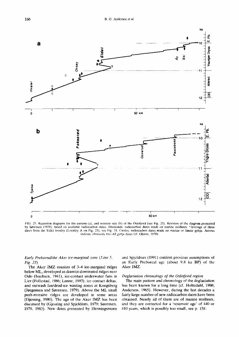
FIG. 25. Recession diagrams for the eastern (a), and western side (b) of the Oslofjord (see Fig. 23). Revision of the diagram.presented by S~rensen (1979), based on available radiocarbon dates. Diamonds: radiocarbon dates made on marine molluscs. *Average of three dates from the Eidet locality (Locality A on Fig, 23), see Fig. 24, Circles: radiocarbon dates made on marine or limnic gyttja. Arrows
indicate obviously too old gyttja dates (cf. Olsson, 1979).
Early Preboreal/the Aker ice-marginal zone (Line 5, Fig. 23)
The Aker IMZ consists of 3-4 ice-marginal ridges below ML, developed as diamict-dominated ridges near Oslo (Isachsen, 1941), ice-contact underwater fans in Lier (Follestad, 1986; L0nne, 1993), ice-contact deltas, and outwash fan/dead-ice wasting zones at Kongsberg (JCrgensen and Sorensen, 1979). Above the ML small push-moraine ridges are developed in some areas (Gjessing, 1980). The age of the Aker IMZ has been discussed by (Gjessing and Spjeldn~es, 1979; S0rensen, 1979, 1983). New dates presented by Henningsmoen
and Spjeldn~es (1991) confirm previous assumptions of an Early Preboreal age (about 9.8 ka BP) of the Aker IMZ.
Deglaciation chronology of the Oslofjord region The main pattern and chronology of the deglaciation
has been known for a long time (cf. Holtedahl, 1960; Andersen, 1965). However, during the last decades a fairly large number of new radiocarbon dates have been obtained. Nearly all of them are of marine molluscs, and they are corrected for a 'reservoir age' of 440 or 410 years, which is possibly too small, see p. 158.

Ice-marginal Deposits in Norway 167
A few gyttja datings (of limnic sediments) are available, and they correspond fairly well to the established chronology based on marine mollusc dates (within two standard deviations of the dates).
Glacial Recession and Oscillations (Fig. 25) The position of the projection lines (I and II, Fig. 23),
has been chosen on the basis of the dominant glacier movements during the time-span discussed. However, a marked change in glacier movement occurred between Late Allered and Early Y.D. on the west side of the Oslofjord (S~arensen, 1992a), and this will introduce some errors in the calculation of recession rates during the AllerOd chron. This presentation shows just an average trend for the Oslofjord region, and is the first revision of the diagram presented by Serensen (1979). It is based on all available radiocarbon dates published later than 1964 and on recent unpublished dates. Average recession rates are given in Table 1. From Older Dryas (O.D.) to Y.D. the recession pattern is similar on both sides of the Oslofjord, mainly due to a similar glacier regime (Serensen, 1990, 1992a). The major re-advance to the Ra IMZ is estimated to 6--7 and 10 km on the eastern and western side of the Oslofjord, respectively. However, the estimates are rather speculative as yet. The final retreat from the Ra ridges to the As/Ski ice-marginal deposits was very rapid on both side of the fjord during the interval from ca. 10.6 to ca. 10.4 ka BP, with decreasing recession rates at the end of the time-interval. At the end of Y.D. the recession rates were very low and details cannot be shown in the diagrams. Particularly on the eastern side of the Oslofjord a pattern of small moraines demonstrates the slow, stepwise glacier-retreat at the end of Y.D (Rosenfeld, 1978; in S¢rensen, 1983). At the transition from Y.D. to Preboreal the recession rates increased rapidly, with a brief interval of glacier- front oscillations along the Aker IMZ.
TABLE 1. Average recession rates (in m yr -t) on both sides of the Oslofjord. Hvaler-Onsey-The Ra Re-advance *As Ski-Tjeme
Slagen Goverud
Projection line I: 35 15 60 90 6 Projection line II: 35 20 30 95 - t
*Assumed values tThe As IMZ is not identified
Recession diagram L for the eastern side of the Oslofjord
'The J~imtland ice lobe' controlled the glacier regime on the eastern side of the Oslofjord as well as southern V~irmland and Dalsland in Sweden, during the Late Glacial. Early Y.D. ice-front oscillations in southwest Sweden are discussed by Bj6rck and Digerfeldt (1984, 1986), Johansson (1982), and Lind (1983).
No direct evidence on the magnitude of the Y.D. glacier-front oscillations is found on the eastern side of the Oslofjord, and the information from Sweden is applied in the diagram.
Recession diagram H for the western side of the Oslofjord
During Y.D. the glacier regime on the western side of the Oslofjord changed considerably. This is explained by the activation of 'The Hardangervidda-Jotunheimen ice lobe' originating from 'The Hardangervidda- Jotunheimen glacier culmination zone' in central Norway (Vorren, 1977; SOrensen, 1983). Evidence for a strong re-advance to the Ra IMZ is the crushed marine shells in clayey diamictons which are common in the Ra from Horten to Krager¢, and the radiocarbon dated sites 'behind' the Ra (Serensen, 1992a) and sub-till AllerOd deposits (Bergstrem, 1994 manuscript).
REFERENCES
Aarseth, I. and Mangerud, J. (1974). Younger Dryas endmoraines between Hardangerfjorden and Sognefjorden, Western Norway. Boreas, 3, 3-22.
Andersen, B.G. (1954). Randmorener i sCrvest Norge. Norsk Geografisk Tidsskrift, 14, 279-342.
Andersen, B.G. (1960). SCrlandet i Sen- og Postglacial Tid. Norges Geologiske Undersckelse, 210, 1-142.
Andersen, B.G. (1965). The Quaternary of Norway. In: Rankama, K. (ed.), The Quaternary 1, pp. 91-138. John Wiley, London.
Andersen, B.G. (1968). Glacial Geology of Western Troms, North Norway. Norges Geologiske Undersckelse, 256, 1-160.
Andersen, B.G, (1975). Glacial Geology of Northern Nordland, North Norway. Norges Geologiske Undersckelse, 320, 1-74.
Andersen, B.G., B6en, F. and Rasmussen, A. (1982). The Tj6tta glacial event in southern Nordland, North Norway. Norsk Geologisk Tidsskrift, 62, 39-49.
Anundsen, K. (1972). Glacial chronology in parts of southwestern Norway. Norges Geologiske Undersckelse, 280, 1-24.
Anundsen, K. (1977). Radiocarbon datings and glacial striae from the inner part of Boknfjord area, South Norway. Norsk Geografisk Tidsskrift, 31, 41-54.
Anundsen, K. (1985). Changes in shore-level and ice-front position in Late Weichsel and Holocene, Southern Norway. Norsk Geografisk Tidsskrift, 39, 205-225.
Bargel, T.H. (ed.), Bergstr6m, B., Hilmo, B.O., Olsen, L., Storr¢, G. and Sveian, H. (1994). Guide til Midtnordenek- skursjonen 1994. Kvart~ergeologl og milj¢geologi i Midt-Norge. Norwegian Geological Survey Report, 94.071, 1--60.
Bergstr¢m, B. (1988). Siljan, Quaternary geological map. 1713-I, scale 1:50 000 with description (in Norwegian). Norges Geologiske Undersekelse, Skrifter, 86, 1-44.
Bergstrem, B. (1993). Isfrontvariasjoner i Nedre Telemark under Aller~ad og Yngre Dryas. Geonytt 20, 15.
Bergstrem, B. (1994). Vikna-Kolvereid, in Bargel et al. 1994. Bergstrem, B. (in preparation). Stratigraphical evidence of a
considerable Younger Dryas glacier advance in southeastern Norway.
BergstrOm, B,, Olsen, K.S. and Serensen, R. (1992). Tjeme, Quaternary geological map. 1813 II, scale 1:50 000 with description on the map (in Norwegian). Norges Geologiske Undersokelse.
Birks, H.H., Pans, Aa., Svendsen, J.I., Aim, T., Mangerud, J. and Landvik, J. (1994). Late Weichselian environmental change in Norway, including Svalbard. Journal of Quaternary Science, 9, 133-145.
Bj6rck, S. and Digerfeldt, G. (1984). Climatic changes at Pleistoeene/Holocene boundary in the Middle Swedish end moraine zone, mainly inferred from stratigraphic indications. In: M6rner, N.-A. and Karl~n, W. (eds), Climatic Changes on a Yearly to Millennial basis, pp. 37-56. Reidel Publishing Company, Dordrecht.
Bj6rck, S. and Digerfeldt, G. (1986). Late Weichselian-Early Holocene shore displacement west of Mt. Billingen, within the Middle Swedish end moraine zone. Boreas, lg, 1-18.
Bjerlykke, K.O. (1990). Lidt om Aas-Mor~enen. Tidsskrfit for Det norske landbrug 7. Christiania.
Blystad, R. and Anundsen, K. (1983). Late Weichselian Stratigraphy at Hielmeland, Southwest Norway. Norsk Geologisk Tidsskrift, 63, 277-287.

168 B.G. Andersen et al.
Boulton, G.S. (1990). Sedimentary and sea level changes during glacial cycles and their control on giacimarine facies architecture. In: J.A. Dowdeswell and J.D. Scourse (eds), Glacimarine Environments: Peocesses and Sediments, pp. 15-52. Geological Society Special Publication 53, London.
Brandai, M.K. and Heder, E. (1991). Stratigraphy and sedhnentation of a terminal moraine deposited in a marine environment - - two examples from the Ra-ridge in Ostfold, southeast Norway. Norsk Geologisk Tidsskrift, 71, 3-14.
Dahl, S.O. and Nesje, A. (1992). Paleodimatic implications based on equilibrium-line altitude depressions of reconstructed Younger Dryas and Holocene cirque giaciers in inner Nordfjord, Western Norway. Palaeogeography, Palaeoclimatology, Palaeoecology, 94, 87-97.
Dahl, A., Olsen, K.S. and Serensen, R. (in press). Holmestrand, Quarternary geological map. 1813 IV, scale 1:50 000 with description on the map (in Norwegian). Norges Geologiske Undersekelse.
Fareth, O.W. (1987). Glacial geology of Middle and Inner Nordfjord, western Norway. Norges Geologiske Undersekelse, 408, 1-55.
Follestad, B.A. (1972). the delgaciation of the south-western parth of the Folgefonn Peninsula, Hordaland. Norges Geologiske Undersekelse, 280, 31--64.
Gjessing, J. (1980). The Aker moraines in southeast Norway. Norsk Geografisk Tidsskrift 34, 9-34.
Gjessing, J. and Spjeldnaes, N. (1979). Dating of the Grefsen moraine and remarks on the deglaciation of southeast Norway. Norsk Geografuk Tidsskrift, 33, 77--81.
Henningsmoen, K.E. and Spjedn~es, N. (1991). Kvart~erdateringer fra SkAdalen ved Oslo. Abstract in Geonytt 18, 26.
Holtedahl, O. (1960). Geology of Norway. Norges geologiske undersekelse, 208, 1-540.
Hoitedahl, H. (1964) An Allered Fauna at Os, near Bergen, Norway. Norsk Geologisk Tidsskrift, 44, 315-322.
Holtedahl, O. (1974). Noen giasifluviale isrand-avsetninger i den sydlige delav Glomma-vassdragets (n~tv~erende) dreneringsomr~ide. Norges Geologiske Undersokelse, 306.
Holtedahl, H. (1975). The Geology of the Hardangerfjord, West Norway. Norges Geologiske Undersekelse, 323, 1-87.
Isachsen, F. (1941"). Grefsenmorenens opbygning og fossilinnhold. Norsk Geologisk Tidsskrfit, 20, 253-262.
Johansson, B.T. (1982). Degiaciationen av Norra Bohnsl/in och S6dra Dalsland. University Gothenburg, Department Geological Publication A 38, 180 pp.
Jergensen, P. and Serensen, R. (1979). Late Glacial and Holocene deglaciation and sedimentation in L~tgendalen, southeastern Norway. Norsk Geologisk Tidsskrfit, 59, 337-343.
Kaldhol, H. (1930). Sunnmores kvart~ergeologi. Norsk Geologisk Tidsskrift, 11, 1-194.
Kj~ernes, P.A. (1986). Askim, Quaternary geological map. 1814-11, scale 1:500 00. Norges Geologiske Undersokelse.
Kj~rnes, P.A. (1984) Sarpsborg, Quaternary geological map. 1913- I, scale 1:50 000. Norges Geologiske Undersekelse.
Klakegg, O. (1991). Drammen, Quaternary geological map. 1814- III, scale 1:50 000, with description on the map (in Norwegian). Norges Geologiske Undersekelse.
Klakegg, O. and Nordahl-Olsen, T. (1985). Nordfjordeid. Beskrivelse til kvartaergeologisk kart 1218 I-M 1:50 000. Norges Geologiske Undersokelse, 71, 1-29.
Klakegg, 0. , Nordahl-Olsen, T., Senstegaard, E. and Aa, A.R. (1989), Sogn og Fjordane, kvart~ergeologisk kart, M 1:250 000. Norges Geologiske Undersekelse.
Klakegg, O. and Serensen, R. (1991). Horten, Quaternary geological map. 1814-Ill, scale 1:50 000, with description on the map (in Norwegian). Norges Geologiske Undersekelse.
Larsen, E., Eide, F., Longva, O. and Mangerud, J. (1984). Allered-Younger Dryas climatic inferences from cirque glaciers and vegetational development in the Nordfjord area, Western Norway. Arctic and Alpine Research, 16, 137-160.
Lind, B. (1983). Deglaciation och h6gsta kustlinjen i Norra Dalsland. University Gothenburg, Department Geological Publication A 43, 175 pp.
Lundqvist, J. (1988). Younger Dryas-Preboreal moraines and deglaciation in southwestern V/irmland, Sweden. Boreas, 17, 301-316.
Lenne, I. (1993). Sedimentology of an Early Holocene ice-contact submarine fan influenced by syndepositional glaciotectonic deformation: Egge-LyngAs, Southern Norway. In: Lenne, I.
(ed.), Sedimentology of Marine Ice-contact Systems in Fjords. Dr. Scient. Thesis, University of Troms¢.
Mangerud, J. (1970). Late Weichselian vegetation and icefront oscillations, in the Bergen district, Western Norway. Norsk Geograf~k Tidsskrift, 24, 121-148.
Mangerud, J. (1977). Late Weichselian marine sediments containing shells, Foraminifera and pollen, at Agotnes, western Norway. Norsk Geologisk Tidsskrift, 57, 23-54.
Mangerud, J. (1980). Ice-front variations of different parts of the Scandinavian Ice Sheet, 13,000--10,000 Years BP. In: Lowe, Gray and Robinson (eds), The Late Glacial of North-West Europe. pp. 23-30. Pergamon Press.
Mangerud, J., Larsen, E., Longva, O. and Senstegaard, E. (1979). Glacial history of western Norway 15,000-10,000 B.P. Boreas, 8, 179-187.
Mangerud, J., Lie, S.E., Fumes, H. Kristiansen, I.L. and I.~mo, L. (1984). A Younger Dryas ash bed in western Norway, with possible correlations to Norwegian Sea and the north Atlantic. Quaternary Research, 21, 85-104.
Marthinussen, M. (1961). Brerandstadier og avsmeltningsforhold i Rappart]ord-Stabbursdal-omrAdet, Finnmark. Norges Geologiske Undersekelse, 213, 118-169.
Marthinussen, M. (1962). 14C-datings referring to shore line, transgressions, and glacial substages in Northern Norway. Norges Geologiske Undersckelse, 215, 37-67.
Marthinussen, M. (1974). Contributions to the Quaternary Geology of North-easternmost Norway and closely adjoining foreign Territories. Norges Geologiske Undersekelse, 315, 1-157.
Nesje, A. and Dahl, S.O. (1992). Equilibrium-line altitude depressions of reconstructed Younger Dryas and Holocene glaciers in Fosdalen, inner Nordfjord, Western Norway. Norsk Geologisk Tidsskrift, 72,209-216.
Nesje, A. and Dahl, S.O. (1993). Lategiacial and Holocene glacier fluctuations and climate variations in Western Norway: a review. Quaternary Science Reviews, 12, 255-261.
Nilsen, D.E. (1978). En kvart~ergeologisk undersekelse i Sandefjordistdktet. University of Oslo, Unpublished Thesis, 136 pp.
Nordahl Olsen, T. (1990). Ski, Quaternary geological map. 1914- III, scale 1:50 000, with description (in Norwegian). Norges Geologiske Undersekelse, Skrifter, 95, 1-33.
Olsen, K.S. and Lewe, A. (1984). Sandefjord, Quaternary geological map. 1813-III, scale 1:50 000. Norges Geologiske Undersekelse.
Oisson, I.U. (1979). A warning against radiocarbon dating of samples containing little carbon. Boreas, 8, 203-207.
Rasmussen, A. (1981). The deglaciation of the coastal area NW of svartisen, Northern Norway. Norges Geologiske Undersekelse, 369, 1-31.
Reite, A.J. (1968). Lokalglaciasjon pA Sunnmere. (On the mountain glaciation of Sunnmere, West Norway.) Norges Geologiske Undersekelse, 247, 262-287.
Reite, A.J. (1994). Weichselian and Holocene geology of S~r Trendelag and adjacent parts of Nord Trondelag county, central Norway. Norges Geologiske Undersekelse, 426, 1-29.
Reite, A.J., Seines, H. and Sveian, H. (1982). A proposed deglaciation chronology for the Trodheimsfjord area, central Norway. Norges Geologiske Undersokelse, 373, 75-84.
Rosenfeld, H.J. (1978). Israndavsetninger i omrAdet Vestby-Ski. Department of Geology, Report 6, 1-21. Agricultural University of Norway.
Rye, N., Nesje, A., Lien, R. and Anda, E. (1987). The Late Weichselian ice sheet in the Nordfjord-Sunnmere area and deglaciation chronology for Nordfjord, Western Norway. Norsk Geografisk Tidsskrift, 41, 23-43.
Rygg, A. (1991). Litostratigrafi og biostratigrafi i et snitt i Raet ved Eidet i Ostfold. 147 pp. Unpublished Thesis, University of Oslo.
Sollid, J.L., Andersen, S., Hamre, N., Kjeldsen, O., Salvigsen, O., Stur6d, S., TveiterA, T. and Wiheimsen. A. (1973). Deglaciation of Finnmark, North Norway. Norsk Geologisk Tidsskrift, 27, 233-325.
Sollid, J.L. and SOrbel, L. (1975). Younger Dryas ice-marginal deposits in Trendelag, Central Norway. Norsk Geografisk Tidsskrift, 29, 1-9.
Sollid, J.L. and Serbel, L. (1979). Deglaciation of Western Central Norway. Boreas, g, 233-239.
Sollid, J.L. and S~rbel, L. (1982). Kort beskrivelse til glacialgeologisk kart over Midt-Norge 1:500 000. Norsk Geografisk Tiddskrift 36, 225-232.

Ice-marginal Deposits in Norway 169
Sveian, H. (1989). Stildestad. KvarUergeologisk kart 1722-IV M:1:50 000. Norges C-eologiske Unders~keise, Skrifter, 89, 1-54.
Sveian, H. (1994). KvartJergeologi i Midt-Norge, in Bargel et al., 1994.
Sveian, H. (/n preparation). Beskrivelse til kvartsergeologisk fylkeskart Nord-Tr~ndelag M: 1:250 000. Norges Geolo$iske Unders~kels.
S~rensen, R. (1979). Late Weichsellan degiaciation in the Oslot]ord area, south Norway. Boreas, 8, 241-246.
S~remen, R. (1983). Glacial deposits in the Oslofjord area. In: Ehlers, J. (ed.), Glacial Deposits in North-west Europe, pp. 19-27. Balkema, Rotterdam.
SCrensen, R. (1990). The Aller~l-Younger Dryas biological and glacial environment in the Oslofjord area, southeastern Norway. Abstract In: Lundqvist, R. and Saarnisto, M. (eds), Termination of the Pleistocenc IGCP-253 Field Conference.ExCursion and Abstracts, pp. 143--144.
Sorensen, R. (1992a). The physical environment of Late Weichselian degiaciation of the Oslofjord region, southeastern Norway. Sveriges Geologiska UndersOkning. Set. Ca 81,339-346.
SCrensen, (1992b). NORDQUA-IGCP 253 excursion on the western side of the Oslofjord, 29 September 1992. Field guide, 20 pp.
S~rensen, R., Lie, K.T. and Nybakken, S.E. (1990). DrCbak, Quaternary geological map. 1814-II, scale 1:50 000 with description on the map (in Norwegian). Norges Geologiske Undersokelse.
Undls, I. (1963). Ra-morenen i Vest-Norge. J.W. Eides Boktrykkeri A.S. Bergen.
Vorren, T. (1977). Weichselian ice movements in south Norway and adjacent areas. Boreas, 6, 247-257.
Ovstedal, D.O. and Aarseth, I. (1975). Bryophytes from Late Weichselian sediments at Vinnes, Western Norway. Lindbergia, 3, 61--68.