world heritage 39 comwhc.unesco.org/archive/2015/whc15-39com-8b-en.pdfworld heritage 39 com...
TRANSCRIPT

World Heritage 39 COM WHC-15/39.COM/8B
Paris, 15 May 2015 Original: English / French
UNITED NATIONS EDUCATIONAL, SCIENTIFIC AND CULTURAL ORGANIZATION
CONVENTION CONCERNING THE PROTECTION OF THE WORLD CULTURAL AND NATURAL HERITAGE
WORLD HERITAGE COMMITTEE
Thirty-ninth session
Bonn, Germany 28 June - 8 July 2015
Item 8 of the Provisional Agenda: Establishment of the World Heritage List and of the List of World Heritage in Danger 8B. Nominations to the World Heritage List
SUMMARY
This document presents the nominations to be examined by the Committee at its 39th session (Bonn, 2015). It is divided into three sections:
Part I Changes to names of properties inscribed on the World Heritage List Part II Examination of nominations of natural, mixed and cultural properties to the World Heritage List Part III Record of the physical attributes of each site being discussed at the 39th session
The document presents for each nomination the proposed Draft Decision based on the recommendations of the appropriate Advisory Body(ies) as included in WHC-15/39.COM/INF.8B1 and WHC-15/39.COM/INF.8B2 and it provides a record of the physical attributes of each property being discussed at the 39th session. The information is presented in two parts:
• a table of the total surface area of each site and any buffer zone proposed, together with the geographic coordinates of each site's approximate centre point; and
• a set of separate tables presenting the component parts of each of the 16 proposed serial properties. Decisions required: The Committee is requested to examine the recommendations and Draft Decisions presented in this Document, and, in accordance with paragraph 153 of the Operational Guidelines, take its Decisions concerning inscription on the World Heritage List in the following four categories: (a) properties which it inscribes on the World Heritage List; (b) properties which it decides not to inscribe on the World Heritage List; (c) properties whose consideration is referred; (d) properties whose consideration is deferred.

I. CHANGES TO NAMES OF PROPERTIES INSCRIBED ON THE WORLD HERITAGE LIST
1. At the request of the Czech authorities, the Committee is asked to approve a change to the English and French names of Holašovice Historical Village Reservation, inscribed on the World Heritage List in 1998.
Draft Decision: 39 COM 8B.1
The World Heritage Committee,
1. Having examined Document WHC-15/39.COM/8B,
2. Approves the name change to Holašovice Historical Village Reservation as proposed by the Czech authorities. The name of the property becomes Holašovice Historic Village in English and Village historique d’Holašovice in French.
II. EXAMINATION OF NOMINATIONS OF NATURAL, MIXED AND CULTURAL PROPERTIES TO THE WORLD HERITAGE LIST
Summary
At its 39th session, the Committee will be examining a total of 38 nominations.
Out of the total of 38 nominations, 30 are new nominations, having not been presented previously, 3 are significant boundary modifications, 1 is a renomination under new criteria and significant boundary modification and 4 nominations were deferred or referred by previous sessions of the Committee.
Of these nominations, ICOMOS and IUCN are recommending 18* nominations for inscription on the World Heritage List and are recommending 3 extensions for approval.
* Please note that the draft decision of 1 nomination referred back by a previous session of the World Heritage Committee is not included in this document [See Addendum: WHC-15/39.COM/8B.Add].
Nominations withdrawn at the request of the State Party
Prior to the preparation of this document, the nomination of Delhi’s Imperial Capital Cities, India, has been withdrawn.
Presentation of Nominations
Within the natural, mixed and cultural groups, nominations are being presented by IUCN and ICOMOS in English alphabetical and regional order: Africa, Arab States, Asia and the Pacific, Europe and North America, Latin America and the Caribbean. The printed Advisory Bodies’ evaluation documents and this working document are presented in this order. As in the past, for ease of reference, an alphabetical summary table and index of recommendations is presented at the beginning of this document (p. 2-3).
Nominations to the World Heritage List WHC-15/39.COM/8B, p. 1

Alphabetical Summary Table and Index of Recommendations by IUCN and ICOMOS to the 39th session of the World Heritage Committee (28 June - 8 July 2015)
State Party World Heritage nomination ID No. Recommendation Criteria proposed by
the State Party Pp
NATURAL SITES
Mongolia / Russian Federation
Landscapes of Dauria 1448 D (ix)(x) 7
South Africa Cape Floral Region Protected Areas [extension of the property “Cape Floral Region Protected Areas”]
1007 Bis OK (ix)(x) 5
Sudan Sanganeb Marine National Park and Dungonab Bay - Mukkawar Island Marine National Park
262 Rev D (vii)(viii)(ix)(x) 6
Thailand Kaeng Krachan Forest Complex 1461 R (x) 8 Viet Nam Phong Nha – Ke Bang National Park [renomination under
criteria (ix) and (x) and extension of “Phong Nha-Ke Bang National Park”]
951 Bis OK (viii) + (ix)(x) 8
MIXED NATURAL AND CULTURAL SITES
Jamaica Blue and John Crow Mountains 1356 Rev I / I (iii)(vi)(ix)(x) 10
CULTURAL SITES
Austria Hall in Tirol – The Mint 1489 N (i)(ii)(iv) 24 China Tusi Sites 1474 I (ii)(iii)(vi) 15 Denmark Christiansfeld a Moravian Settlement 1468 I (iii)(iv) 24 Denmark The par force hunting landscape in North Zealand 1469 I (ii) 25 Denmark / Germany / Iceland / Latvia / Norway
Viking Age Sites in Northern Europe 1476 D (iii)(iv) 27
France Climats, terroirs of Burgundy 1425 R (iii)(v) 28 France Champagne Hillsides, Houses and Cellars 1465 I (iii)(iv)(vi) 28 Georgia Gelati Monastery [Significant boundary modification of
“Bagrati Cathedral and Gelati Monastery”] 710 Bis R (iv) 39
Germany Speicherstadt and Kontorhaus District with Chilehaus
1467 I (i)(ii)(iii)(iv) 30
Germany The Naumburg Cathedral and the landscape of the rivers Saale and Unstrut - territories of power in the High Middle Ages
1470 N (iv)(v) 32
Iran (Islamic Republic of)
Susa 1455 I (i)(ii)(iii)(iv) 16
Iran (Islamic Republic of)
Cultural Landscape of Maymand 1423 Rev (see 8B.Add) (iii)(iv)(v) 23
Israel Bet She’arim Necropolis – A landmark of Jewish Renewal
1471 I (ii)(iii)(vi) 32
Italy Arab-Norman Palermo and the Cathedral Churches of Cefalú and Monreale
1487 I (ii)(iv) 33
Japan Sites of Japan’s Meiji Industrial Revolution: Kyushu-Yamaguchi and Related Areas
1484 I (ii)(iii)(iv) 18
Jordan Baptism Site “Bethany Beyond the Jordan” (Al-Maghtas)
1446 R (iii)(iv)(vi) 14
Kenya Thimlich Ohinga Cultural Landscape 1450 D (iii)(iv) 13 Mexico Aqueduct of Padre Tembleque, Renaissance
Hydraulic Complex in America 1463 I (i)(ii)(iv)(v)(vi) 42
Mongolia Great Burkhan Khaldun Mountain and its surrounding sacred landscape
1440 R (iii)(iv)(v)(vi) 21
Norway Rjukan – Notodden Industrial Heritage Site 1486 I (ii)(iv) 34 Republic of Korea Baekje Historic Areas 1477 I (ii)(iii)(iv) 21 Romania Monumental Ensemble of Târgu Jiu 1473 N (i)(ii) 35 Saudi Arabia Rock Art in the Hail Region of Saudi Arabia 1472 R (i)(ii)(iii)(v) 15 Singapore Singapore Botanic Gardens 1483 I (ii)(iv) 22 Spain La Rioja and Rioja Alavesa Wine and Vineyard
Cultural Landscape 1482 D (ii)(iii)(v)(vi) 35
Nominations to the World Heritage List WHC-15/39.COM/8B, p. 2

State Party World Heritage nomination ID No. Recommendation Criteria proposed by the State Party
Pp
Spain Routes of Santiago in Northern Spain [Extension of “Routes of Santiago de Compostela”]
669 Bis OK (ii)(iv)(vi) 39
Turkey Ephesus 1018 Rev I (i)(ii)(iii)(iv)(vi) 41 Turkey Diyarbakır Fortress and Hevsel Gardens Cultural
Landscape 1488 R (i)(ii)(iii)(iv)(v) 36
Uganda Nyero and other hunter-gatherer geometric rock art sites in eastern Uganda
1491 D (iii)(vi) 14
United Kingdom The Forth Bridge 1485 I (i)(ii)(iv) 36 United States of America
San Antonio Missions 1466 I (ii)(iii)(iv) 37
Uruguay Fray Bentos Cultural-Industrial Landscape 1464 I (ii)(iv)(vi) 44 KEY
I Recommended for inscription R Recommended for referral D Recommended for deferral OK Approval Recommended of an extension or a modification N Not recommended for inscription NA Not approved extension (i) (ii) etc Cultural and/or Natural criteria proposed by the State Party Nominations highlighted in bold are considered "new", having not been presented to the Committee previously.
Nominations to the World Heritage List WHC-15/39.COM/8B p. 3

Order of presentation of nominations to be examined at the 39th session of the World Heritage Committee
Order State Party World Heritage nomination Recomm. Draft Decision
NATURAL SITES
1 South Africa Cape Floral Region Protected Areas [extension of the property “Cape Floral Region Protected Areas”]
OK 39 COM 8B.2
2 Sudan Sanganeb Marine National Park and Dungonab Bay - Mukkawar Island Marine National Park
D 39 COM 8B.3
3 Mongolia / Russian Federation
Landscapes of Dauria D 39 COM 8B.4
4 Thailand Kaeng Krachan Forest Complex (KKFC) R 39 COM 8B.5 5 Viet Nam Phong Nha – Ke Bang National Park [renomination under criteria (ix) and
(x) and extension of “Phong Nha-Ke Bang National Park”] OK 39 COM 8B.6
MIXED NATURAL AND CULTURAL SITES 6 Jamaica Blue and John Crow Mountains I / I 39 COM 8B.7
CULTURAL SITES
7 Kenya Thimlich Ohinga Cultural Landscape D 39 COM 8B.8 8 Uganda Nyero and other hunter-gatherer geometric rock art sites in eastern Uganda D 39 COM 8B.9 9 Jordan Baptism Site “Bethany Beyond the Jordan” (Al-Maghtas) R 39 COM 8B.10 10 Saudi Arabia Rock Art in the Hail Region of Saudi Arabia R 39 COM 8B.11 11 China Tusi Sites I 39 COM 8B.12 12 Iran (Islamic Republic of) Susa I 39 COM 8B.13 13 Japan Sites of Japan’s Meiji Industrial Revolution: Kyushu-Yamaguchi and Related
Areas I 39 COM 8B.14
14 Mongolia Great Burkhan Khaldun Mountain and its surrounding sacred landscape R 39 COM 8B.15 15 Republic of Korea Baekje Historic Areas I 39 COM 8B.16 16 Singapore Singapore Botanic Gardens I 39 COM 8B.17 17 Iran (Islamic Republic of) Cultural Landscape of Maymand (see
8B.Add) 39 COM 8B.18
18 Austria Hall in Tirol – The Mint N 39 COM 8B.19 19 Denmark Christiansfeld a Moravian Settlement I 39 COM 8B.20 20 Denmark The par force hunting landscape in North Zealand I 39 COM 8B.21 21 Denmark / Germany /
Iceland / Latvia / Norway Viking Age Sites in Northern Europe D 39 COM 8B.22
22 France Climats, terroirs of Burgundy R 39 COM 8B.23 23 France Champagne Hillsides, Houses and Cellars I 39 COM 8B.24 24 Germany Speicherstadt and Kontorhaus District with Chilehaus I 39 COM 8B.25 25 Germany The Naumburg Cathedral and the landscape of the rivers Saale and Unstrut
- territories of power in the High Middle Ages N 39 COM 8B.26
26 Israel Bet She’arim Necropolis – A landmark of Jewish Renewal I 39 COM 8B.27 27 Italy Arab-Norman Palermo and the Cathedral Churches of Cefalú and Monreale I 39 COM 8B.28 28 Norway Rjukan – Notodden Industrial Heritage Site I 39 COM 8B.29 29 Romania Monumental Ensemble of Târgu Jiu N 39 COM 8B.30 30 Spain La Rioja and Rioja Alavesa Wine and Vineyard Cultural Landscape D 39 COM 8B.31 31 Turkey Diyarbakır Fortress and Hevsel Gardens Cultural Landscape R 39 COM 8B.32 32 United Kingdom The Forth Bridge I 39 COM 8B.33 33 United States of America San Antonio Missions I 39 COM 8B.34 34 Georgia Gelati Monastery [Significant boundary modification of “Bagrati Cathedral
and Gelati Monastery” inscribed in 1994 under criterion (iv)] R 39 COM 8B.35
35 Spain Routes of Santiago in Northern Spain [Extension of “Routes of Santiago de Compostela”]
OK 39 COM 8B.36
36 Turkey Ephesus I 39 COM 8B.37 37 Mexico Aqueduct of Padre Tembleque, Renaissance Hydraulic Complex in
America I 39 COM 8B.38
38 Uruguay Fray Bentos Cultural-Industrial Landscape I 39 COM 8B.39
Nominations to the World Heritage List WHC-15/39.COM/8B, p. 4

In the presentation below, IUCN Recommendations and ICOMOS Recommendations are both presented in the form of draft Decisions and are abstracted from WHC-15/39.COM/INF.8B1 (ICOMOS) and WHC-15/39.COM/INF.8B2 (IUCN).
Though draft Decisions were taken from IUCN and ICOMOS evaluations books, in some cases, a few modifications were required to adapt them to this document.
A. NATURAL SITES
A.1. AFRICA
A.1.1. Extensions of properties Extensions of properties already inscribed on the World Heritage List
Property Cape Floral Region Protected Areas [extension of the property “Cape Floral Region Protected Areas”]
Id. N° 1007 Bis State Party South Africa Criteria proposed by State Party
(ix)(x)
See IUCN Evaluation Book, May 2015, page 3.
Draft Decision: 39 COM 8B.2
The World Heritage Committee,
1. Having examined Documents WHC-15/39.COM/8B and WHC-15/39.COM/INF.8B2,
2. Approves the extension of Cape Floral Region Protected Areas, South Africa, on the World Heritage List on the basis of criteria (ix) and (x);
3. Adopts the following Statement of Outstanding Universal Value:
Brief synthesis The Cape Floral Region has been recognised as one of the most special places for plants in the world in terms of diversity, density and number of endemic species. The property is a highly distinctive phytogeographic unit which is regarded as one of the six Floral Kingdoms of the world and is by far the smallest and relatively the most diverse. It is recognised as one of the world’s ʻhottest hotspotsʼ for its diversity of endemic and threatened plants, and contains outstanding examples of significant ongoing ecological, biological and evolutionary processes. This extraordinary assemblage of plant life and its associated fauna is represented by a series of 13 protected area clusters covering an area of more than 1 million ha. These protected areas also conserve the outstanding ecological, biological and evolutionary processes associated with the
beautiful and distinctive Fynbos vegetation, unique to the Cape Floral Region. Criterion (ix): The property is considered of outstanding universal value for representing ongoing ecological and biological processes associated with the evolution of the unique Fynbos biome. These processes are represented generally within the Cape Floral Region and captured in the component areas that make up the 13 protected area clusters. Of particular scientific interest are the adaptations of the plants to fire and other natural disturbances; seed dispersal by ants and termites; the very high level of plant pollination by insects, mainly beetles and flies, birds and mammals; and high levels of adaptive radiation and speciation. The pollination biology and nutrient cycling are other distinctive ecological processes found in the site. The Cape Floral Region forms a centre of active speciation where interesting patterns of endemism and adaptive radiation are found in the flora. Criterion (x): The Cape Floral Region is one of the richest areas for plants when compared to any similar sized area in the world. It represents less than 0.5% of the area of Africa but is home to nearly 20% of the continent’s flora. The outstanding diversity, density and endemism of the flora are among the highest worldwide. Some 69% of the estimated 9,000 plant species in the region are endemic, with 1,736 plant species identified as threatened and with 3,087 species of conservation concern. The Cape Floral Region has been identified as one of the world’s 35 biodiversity hotspots. Integrity The originally inscribed Cape Floral Region Protected Areas serial property comprised eight protected areas covering a total area of 557,584 ha, and included a buffer zone of 1,315,000 ha. The extended Cape Floral Region Protected Areas property comprises 1,094,742 ha of protected areas and is surrounded by a buffer zone of 798,514 ha. The buffer zone is made up of privately owned, declared Mountain Catchment Areas and other protected areas, further supported by other buffering mechanisms that are together designed to facilitate functional connectivity and mitigate for the effects of global climate change and other anthropogenic influences. The collection of protected areas adds up in a synergistic manner to present the biological richness and evolutionary story of the Cape Floral Region. All the protected areas included in the property, except for some of the privately owned, declared Mountain Catchment Areas, have existing dedicated management plans, which have been revised, or are in the process of revision in terms of the National Environmental Management: Protected Areas Act. Mountain Catchment Areas are managed in terms of the Mountain Catchment Areas Act.
Nominations to the World Heritage List WHC-15/39.COM/8B, p. 5

Progress with increased protection through public awareness and social programmes to combat poverty, improved management of mountain catchment areas and stewardship programmes is being made. Protection and management requirements The serial World Heritage property and its component parts, all legally designated protected areas, are protected under the National Environmental Management: Protected Areas Act (57 of 2003). The property is surrounded by extensive buffer zones (made up of privately owned, declared Mountain Catchment Areas and other protected areas) and supported by various buffering mechanisms in the region. Together, these provide good connectivity and landscape integration for most of the protected area clusters, especially in the mountain areas. The protected areas that make up the property are managed by three authorities South African National Parks (SANParks), Western Cape Nature Conservation Board (CapeNature) and Eastern Cape Parks and Tourism Agency. These authorities, together with the national Department of Environmental Affairs, make up the Joint Management Committee of the property. All of the sites are managed in accordance with agreed management plans, however, there is a recognised need for a property-wide management strategy in the form of an Environmental Management Framework. Knowledge management systems are being expanded to advise improved planning and management decision-making, thus facilitating the efficient use of limited, but increasing, resources relating in particular to the management of fire and invasive alien species. The provision of long-term, adequate funding to all of the agencies responsible for managing the property is essential to ensure effective management of the multiple components across this complex serial site. Invasive alien species and fire are the greatest management challenges facing the property at present. Longer-term threats include climate change and development pressures caused by a growing population, particularly in the Cape Peninsula and along some coastal areas. These threats are well understood and addressed in the planning and management of the protected areas and their buffer zones. Invasive species are being dealt with through manual control programmes that have been used as a reference for other parts of the world.
4. Commends the State Party for its review of the nomination boundaries to bring forward an extension of the property which, on the basis of fine scale scientific analysis, significantly increases the number of Fynbos vegetation types protected within the property and strengthens the property’s integrity;
5. Encourages the State Party to address longstanding shortfalls in financial resources which are impeding management of the property and which will be increasingly important in light of the substantially increased area and complexity of the extended property;
6. Requests the State Party to complete the Environmental Management Framework and submit a copy to the World Heritage Centre by 1 February 2017 and to strengthen the role and resources of the Joint Management Committee so that it can more effectively act as a single coordinating authority that guides management across all inscribed component parts of the property;
7. Also requests the State Party to submit to the World Heritage Centre, by 1 December 2017, a report on the state of conservation of the property, including progress on the finalization of a property-wide integrated management plan; strengthened governance arrangements to improve coordination; and the implementation of actions to ensure adequate financial resources for the property’s management, for examination by the World Heritage Committee at its 42nd session in 2018.
A.1.2. Properties deferred or referred back by previous sessions of the World Heritage Committee
Property Sanganeb Marine National Park and Dungonab Bay - Mukkawar Island Marine National Park
Id. N° 262 Rev State Party Sudan Criteria proposed by State Party
(vii)(viii)(ix)(x)
See IUCN Evaluation Book, May 2015, page 15.
Draft Decision: 39 COM 8B.3
The World Heritage Committee,
1. Having examined Documents WHC-15/39.COM/8B and WHC-15/39.COM/INF.8B2,
2. Defers the examination of the nomination of the Sanganeb Marine National Park and Dungonab Bay – Mukkawar Island Marine National Park, Sudan, to the World Heritage List, taking note of its potential to meet natural criteria (vii), (ix) and (x), in order to allow the State Party to prepare a revised nomination taking into account the need to:
a) Review, with the support of IUCN, the boundaries of the property to better define the nominated area and buffer zones to ensure that all the natural attributes which contribute to the globally significant values are appropriately included and that integrity
Nominations to the World Heritage List WHC-15/39.COM/8B p. 6

is enhanced. Specifically, consideration should be given to including the designated marine buffer zone area of Sanganeb Marine National Park and other reefs (included in the buffer zone) within the nominated area; to expanding the nominated area to include more of the terrestrial component of Dungonab Marine National Park designated buffer zone; and to incorporating other attributes contributing to Outstanding Universal Value which lie within the linking buffer zone;
b) Update the management plans for Sanganeb Marine National Park and Dungonab Marine National Park and develop an integrated management framework for the whole property that guides coordinated inter-agency policy and management and promotes the effective involvement of different stakeholders including local communities;
c) Demonstrate significantly increased financial resources and staffing capacity to ensure an adequate level of effective management of the nominated property and provide assurances to the World Heritage Committee on commitments to maintain ongoing sustainable financing.
3. Commends the State Party for its efforts to legally protect Sanganeb Marine National Park and Dungonab Marine National Park, improve interagency cooperation and for collaborative initiatives to engage local communities in the management of the area.
A.2. ASIA / PACIFIC
A.2.1. New Nominations
Property Landscapes of Dauria Id. N° 1448 State Party Mongolia / Russian
Federation Criteria proposed by State Party
(ix)(x)
See IUCN Evaluation Book, May 2015, page 29.
Draft Decision: 39 COM 8B.4
The World Heritage Committee,
1. Having examined Documents WHC-15/39.COM/8B and WHC-15/39.COM/INF.8B2,
2. Defers the examination of the nomination of Landscapes of Dauria, Mongolia and Russian Federation, to the World Heritage List, noting the potential for a nomination in the wider Daurian Steppes Ecoregion to meet natural criteria (ix) and (x), in order to allow the States Parties to prepare a significantly revised nomination taking into account the need to:
a) Review, with the support of IUCN, the boundaries of the nominated area and buffer zones to include areas important for the protection of forest steppe ecosystems which are an essential component to demonstrate Outstanding Universal Value, and are currently poorly represented within the nominated property and to ensure the property is designed with boundaries that better support the critical habitat of migratory birds and habitat associated with the migration of Mongolian Gazelle;
b) Prepare a joint management plan for the property to ensure a strengthened approach to sustainable regional development, tourism planning, threatened species conservation actions, research, monitoring and environmental education. This plan should be developed consistent with the transboundary framework provided by the Joint Commission between the States Parties of the Russian Federation, Mongolia and China supporting the Dauria International Protected Area (DIPA) initiative.
3. Requests the States Parties to strengthen transnational collaboration to mitigate threats and ensure consistent capacity and effectiveness in both the Russian Federation and Mongolian components of the property, and specifically to:
a) develop strengthened, better coordinated policies, practices and action plans to combat the threat of fire;
b) develop strengthened, better coordinated management of buffer zones including with regard to grazing and cutting, in order to prevent overexploitation;
c) establish enhanced legal and other measures to reduce hunting and poaching pressures on the property;
d) provide the necessary long term resourcing and capacity to address imbalances and ensure effective management across the transnational property as a whole.
4. Also requests the State Party of Mongolia, in line with the position of the World Heritage Committee on the incompatibility of mining with World Heritage site status, to confirm unequivocally that mining exploration and exploitation activities will not be permitted within the nominated property;
5. Commends the State Parties of the Russian Federation and Mongolia for their commitment to the protection of important Central Asian steppe ecosystems which remain poorly represented on the World Heritage List;
6. Further requests IUCN in consultation with the relevant States Parties, to update the 2005 Central Asia Regional Thematic Study on natural World Heritage to identify at a regional scale the most outstanding steppe areas with
Nominations to the World Heritage List WHC-15/39.COM/8B p. 7

potential for future nomination to the World Heritage List.
Property Kaeng Krachan Forest Complex (KKFC)
Id. N° 1461 State Party Thailand Criteria proposed by State Party
(x)
See IUCN Evaluation Book, May 2015, page 41.
Draft Decision: 39 COM 8B.5
The World Heritage Committee,
1. Having examined Documents WHC-15/39.COM/8B and WHC-15/39.COM/INF.8B2,
2. Refers the nomination of the Kaeng Krachan Forest Complex, Thailand, back to the State Party, in relation to natural criteria, taking note of the strong potential for this property to meet criterion (x), in order to allow it to:
a) Address in full the concerns that have been raised by the Office of the United Nations High Commissioner for Human Rights concerning Karen communities within the Kaeng Krachan National Park including the implementation of a participatory process to resolve rights and livelihoods concerns and to achieve a consensus of support for the nomination that is fully consistent with the principle of free, prior and informed consent;
b) Provide updated data on the conservation status of key populations of threatened species, based on the most recent information available, to confirm their viability and contribution to the distinctive global values of the nominated property.
3. Encourages the State Party to consider nominating the property also under criterion (ix);
4. Also encourages the State Party to continue the commendable initiatives on future biological connectivity opportunities including those between the nominated property and Thungyai - Huai Kha Khaeng Wildlife Sanctuaries in Thailand and, working in partnership with the State Party of Myanmar, between the nominated property and neighbouring transnational protected areas within the Taninthaya Forest Corridor in Myanmar;
5. Commends the State Party and partner NGOs for their efforts to address improved conservation management within the property including improved anti-poaching patrol systems, community engagement in Kui Buri National Park dealing with human/elephant conflict, and enhanced ecological research and monitoring, and encourages the State Party to continue with these efforts.
A.2.2. Extensions of properties inscribed on the World Heritage List
Property Phong Nha – Ke Bang National Park [renomination under criteria (ix) and (x) and extension of “Phong Nha-Ke Bang National Park”]
Id. N° 951 Bis State Party Viet Nam Criteria proposed by State Party
(viii) + (ix)(x)
See IUCN Evaluation Book, May 2015, page 53.
Draft Decision: 39 COM 8B.6
The World Heritage Committee,
1. Having examined Documents WHC-15/39.COM/8B and WHC-15/39.COM/INF.8B2,
2. Approves the extension and renomination of Phong Nha-Ke Bang National Park, Viet Nam, on the World Heritage List on the basis of criteria (viii), (ix) and (x);
3. Adopts the following Statement of Outstanding Universal Value:
Brief synthesis Phong Nha - Ke Bang National Park is located in the middle of the Annamite Mountain Range in Quang Binh province, Viet Nam, and shares its boundary with the Hin Namno Nature Reserve in the Lao PDR to the west. The property comprises an area of 123,326 ha and contains terrestrial and aquatic habitats, primary and secondary forest, sites of natural regeneration, tropical dense forests and savanna and is rich in large, often spectacular and scientifically significant caves. The property contains and protects over 104 km of caves and underground rivers making it one of the most outstanding limestone karst ecosystems in the world. The karst formation has evolved since the Palaeozoic period (some 400 million years ago) and as such is the oldest major karst area in Asia. Subject to massive tectonic changes, the karst landscape is extremely complex, comprising a series of rock types that are interbedded in complex ways and with many geomorphic features. The karst landscape is not only complex but also ancient, with high geodiversity and geomorphic features of considerable significance. The karst formation process has led to the creation of not only underground rivers but also a variety of cave types including: dry caves, terraced caves, suspended caves, dendritic caves and intersecting caves. With a length of over 44.5 km the Phong Nha cave is the most famous of the system with tour boats able to penetrate inside to a distance of 1,500 m. The Son Doong Cave, first explored in 2009, is believed to contain the world’s largest cave passage in terms of diameter and continuity.
Nominations to the World Heritage List WHC-15/39.COM/8B p. 8

A large number of faunal and floral species occur within the property with over 800 vertebrate species recorded comprising 154 mammals, 117 reptiles, 58 amphibians, 314 birds and 170 fish. The property clearly has impressive levels of biodiversity within its intact forest cover, however, up-to-date data on large mammal species is needed to confirm the population status of reported large mammals including tiger, Asiatic black bear, Asian elephant, giant muntjac, Asian wild dog, gaus and the recently discovered saola. Criterion (viii): Phong Nha-Ke Bang National Park is part of a larger dissected plateau, which encompasses the Phong Nha, Ke Bang and Hin Namno karsts. The limestone is not continuous and demonstrates complex interbedding with shales and sandstones. This has led to a particularly distinctive topography. The caves demonstrate a discrete sequence of events, leaving behind different levels of ancient abandoned passages; evidence of major changes in the routes of underground rivers; changes in the solutional regime; deposition and later re-solution of giant speleothems and unusual features such as sub-aerial stromatolites. On the surface, there is a striking series of natural landscapes, ranging from deeply dissected ranges and plateaux to an immense polje. There is evidence of at least one period of hydrothermal activity in the evolution of this ancient mature karst system. The Son Doong Cave, first explored in 2009, could contain the world’s largest cave passage in terms of diameter and continuity. The plateau is one of the finest and most distinctive examples of a complex karst landform in Southeast Asia and the property is of great importance for enhancing our understanding of the geologic, geomorphic and geo-chronological history of the region. Criterion (ix): Phong Nha-Ke Bang National Park consists of a complex limestone landscape, which includes very large caves and underground rivers. The property includes karst formations which are some of the oldest and largest in Asia, and it has geological, climatic, hydrographic and ecological conditions which are distinct from other limestone karst landscapes. Its cave ecosystems and habitats are unique with high levels of endemism and adaptations displayed by cave-dependent species. The property constitutes one of the largest remaining areas of relatively intact moist forest on karst in Indochina, with a forest cover estimated to reach 94%, of which 84% is thought to be primary forest. Furthermore, the property protects globally significant ecosystems within the Northern Annamites Rainforests and Annamite Range Moist Forests priority ecoregions. Criterion (x): A high level of biodiversity is found within the property, with over 2,700 species of vascular plants and over 800
vertebrate species. Several globally threatened species are also present: 133 plant species and 104 vertebrate species have been reported, including several large mammals such as the endangered Large-antlered Muntjac, Clouded Leopard, and the critically endangered Saola. The level of endemism is high, especially in the cave systems. Furthermore, it is estimated that over 400 plant species endemic to Viet Nam are found within the property, as well as 38 animal species endemic to the Annamite range. Several new species to science have recently been found, including cave scorpions, fish, lizards, snakes and turtles, and more species are likely to be discovered. Importantly, four threatened primate taxa endemic to the Annamites are found within the property: the Hatinh Langur (specialised in karst forest and endemic to Viet Nam and the People’s Democratic Republic of Lao), the black form of the Hatinh Langur, sometimes considered as a separate species, the Red-shanked Douc Langur, and the largest remaining population of White-cheeked Gibbon. Integrity The property constitutes one of the largest protected karst landscapes in South East Asia. Covering an area of 123,326 ha and bounded to the west by the Lao People’s Democratic Republic, all elements necessary to manifest the outstanding geological values of the property of Phong Nha - Ke Bang National Park are contained within the boundaries of the property. The inscribed property is completely surrounded and protected by a buffer zone of 220,055 ha and is designated into three management zones: a strictly protected, an ecological restoration and an administrative/service zone. The watershed protection forests in the buffer zone also protect the integrity of the property. Furthermore, the extension of the property enhances its integrity and connectivity with the karst landscape in Lao PDR. There are, however, a number of issues that affect the integrity of the property. Wildlife poaching and illegal harvesting of forest products is a direct threat to biodiversity values. The property has also suffered from past developments and its integrity could be threatened by further uncontrolled tourism developments, notably by the proposed construction of a cable car and access roads. There is a need for the implementation of Environmental Impact Assessments for any projects which could negatively affect the site. This would ensure that the natural landscape, geologic and geomorphic values, and key features such as primitive forest, caves, rivers and streams within the inscribed area remain intact. The property is situated within an area of high population density and as such a number of activities, such as cultivation, tourism, transport and freshwater fisheries could also impact on its integrity.
Nominations to the World Heritage List WHC-15/39.COM/8B p. 9

Protection and management requirements Originally designated as a Nature Reserve in 1986, Phong Nha - Ke Bang National Park was established in 2001 under the Decision 189/QD-TTg by the Prime Minister and is managed by a Management Board. The Management Board is responsible for protection of forest resources and biodiversity and was established in 1994. Cave conservation and the provision of a tourism service are the responsibility of the Cultural and Ecological Tourist Centre under the Management Board. The property is also included in the Special National Heritage List (2009), and the Special Use Forest system (1999). The National Park is effectively protected by a number of national laws and government decisions, which prohibit any action inside or outside the boundaries of the National Park or a World Heritage property that may have a significant impact on the heritage values. A Strategic Management Plan has been in place since 2012 and is based on existing plans, including the Sustainable Tourism Development Plan, the National Park Operation Management Plan and the Buffer Zone Development Plan. The Management Board oversees law enforcement programmes including ranger patrols and joint law enforcement operations on the border with Lao PDR. Nevertheless, the rugged nature of the country and community dependence on natural resources coupled with relatively limited resources for enforcement means that wildlife poaching and illegal timber gathering are difficult to eradicate and remain a challenging issue. The Ho Chi Minh highway, constructed outside and to the north of the property is appropriately located and provides important and valuable benefit to the National Park in terms of opening up views of and access to the Ke Bang forest area. However, other road construction and tourism development will require rigorous and comprehensive assessment of environmental impact before decisions are made on whether they should be permitted or not. It is paramount that such developments do not impact on the karst and biological values for which the property has been inscribed. Impacts of increased development pressure and tourism numbers will also require continual consideration, planning and management to ensure that these pressures do not damage the Outstanding Universal Value of the property.
4. Commends the efforts made by the State Party to address the recommendations of the World Heritage Committee regarding the integrity, protection and management of the property;
5. Notes with concern proposals to construct a cable car to provide access to the Son Doong cave within the strictly protected zone of the property and the potential impacts this may
have on the property’s Outstanding Universal Value and urges the State Party to complete Environmental Impact Assessments, in line with IUCN’s Advice Note on Environmental Assessment, prior to a decision on the implementation of any tourism development projects and to ensure that development proposals are not permitted if they would negatively impact the Outstanding Universal Value of the property;
6. Requests the State Party to revise the property’s Sustainable Tourism Development Plan to include the property extension and ensure an integrated and environmentally sensitive approach to tourism that ensures visitor use remains compatible with the Outstanding Universal Value of the property;
7. Also requests the State Party to submit to the World Heritage Centre, by 1 February 2016, a report on the state of conservation of the property, including updated data on the population status of key large mammal species; advice on the status of proposals to construct a cable car to access Son Doong Cave; and advice on sustainable financing for the extended property, for examination by the World Heritage Committee at its 40th session in 2016.
B. MIXED SITES
B.1. LATIN AMERICA / CARIBBEAN
B.1.1. Properties deferred or referred back by previous sessions of the World Heritage Committee
Property Blue and John Crow Mountains
Id. N° 1356 Rev State Party Jamaica Criteria proposed by State Party
(iii)(vi)(ix)(x)
See IUCN Evaluation Book, May 2015, page 69. See ICOMOS Evaluation Book, May 2015, page 21.
Draft Decision: 39 COM 8B.7
The World Heritage Committee,
1. Having examined Documents WHC-15/39.COM/8B, WHC-15/39.COM/INF.8B1 and WHC-15/39.COM/INF.8B2,
2. Inscribes the Blue and John Crow Mountains, Jamaica, on the World Heritage List on the basis of criteria (iii), (vi) and (x);
3. Adopts the following Statement of Outstanding Universal Value:
Nominations to the World Heritage List WHC-15/39.COM/8B p. 10

Brief synthesis The cultural and natural heritage of the Blue and John Crow Mountains comprises 26,252 ha of tropical, montane rainforest within the larger Blue Mountain and John Crow Mountain ranges, located in the eastern part of Jamaica in the Caribbean. These two ranges cover approximately 20% of the island’s total landmass and are recognised for their biodiversity significance within the Caribbean Region. The property spans elevations from 850m to 2,256m asl and is surrounded by a buffer zone of some 28,494 ha. The high elevation, rugged landscape and the north and south-facing slopes of the mountains of the property have resulted in a wide variety of habitat types with nine ecological communities within the upper montane forest of the Blue Mountains (over 1,000m) and John Crow Mountains (over 600m). These include a unique Mor Ridge Forest characterised by a deep layer of acidic humus with bromeliads and endangered tree species. Above 1,800m, the vegetation of the Blue Mountains is more stunted with some species restricted to these altitudes. Above 2,000m the forest is known as Elfin Forest due to the stunted and gnarled appearance of the trees which are heavily coated with epiphytes including hanging mosses, ferns and tiny orchids. The Blue and John Crow Mountains property lies within the Jamaican Moist Forests Global 200 priority eco-region, and is part of one of the 78 most irreplaceable protected areas for the conservation of the world’s amphibian, bird and mammal species. Furthermore it coincides with a Centre of Plant Diversity; an Endemic Bird Area and contains two of Jamaica’s five Alliance for Zero Extinction sites. There is an exceptionally high proportion of endemic plant and animal species found in the property, Jamaica having evolved separately from other landmasses. In addition, the property hosts a number of globally endangered species, including several frog and bird species. The Blue and John Crow Mountains property offered refuge to Maroons (escaped indigenous slaves) and therefore preserves the tangible cultural heritage associated with the Maroon story. This includes settlements, trails, viewpoints, hiding places, etc. that form the Nanny Town Heritage Route. The forests and their rich natural resources provided everything the Maroons needed to survive, to fight for their freedom, and to nurture their culture. Maroon communities still hold strong spiritual associations with these mountains, expressed through exceptional intangible manifestations. Criterion (iii): The Blue and John Crow Mountains in combination with its cultural heritage, materialised by the Nanny Town Heritage Route and associated remains, i.e. secret trails, settlements, archaeological remains, look-outs, hiding places etc., bear
exceptional witness to Windward Maroon culture which, in the search for freedom from colonial enslavement, developed a profound knowledge of, and attachment to, their environment, that sustained and helped them to achieve autonomy and recognition. Criterion (vi): Blue and John Crow Mountains is directly associated with events that led to the liberation, and continuing freedom and survival, of groups of fugitive enslaved Africans that found their refuge in the Blue and John Crow Mountains. The property conveys outstandingly its association with living traditions, ideas and beliefs that have ensured that survival, and the specificity and uniqueness of which was recognised by UNESCO in 2008 through its inscription in the Representative List of Intangible Heritage. Criterion (x): The Blue and John Crow Mountains belongs to the Caribbean Islands biodiversity hotspot and is an important centre for plant endemism in the Caribbean displaying 50% endemicity in the flowering plants at elevations above 900-1000 m asl with between 30-40 % of these species found only within the property’s boundaries. One of two Centres of Plant Diversity in Jamaica, the property includes a reported 1,357 species of flowering plant of which approximately 294 are Jamaican endemics and 87 of these species are found only within the property. 61 species of liverwort and moss occur in the property as well as 11 species of lichen, all of which are endemic. Genera which are well represented in the endemic flora of the property include Pilea (12 spp); Lepanthes (12 spp); Psychotria (12 spp) and Eugenia (11 spp). The Blue and John Crow Mountains overlaps with one of the world’s most irreplaceable protected areas, based on its importance for amphibian, bird and mammal species. The property hosts globally significant populations of bird species and represents a key part of the Jamaican Endemic Bird Area. It is important for a number of restricted-range species as well as a large number of migratory birds such as the Petchary (Tyrannus domenciensis) Bicknell’s Thrush (Catharus bicknellii) and Swainson’s Warbler (Limnothlypis swainsonii). The property contains two of Jamaica’s five Alliance for Zero Extinction sites, hosting a significant number of globally endangered species, including the critically endangered plant species Podocarpus urbanii, Eugenia kellyana and Psychotria danceri. The property is also home to several endangered frog and bird species including the critically endangered Arntully Robber Frog, Eleutherodactylus orcutti and the Jamaican Peak Frog, E. alticola. Threatened bird species include Bicknell's Thrush C. bicknellii, the Jamaican Blackbird, Nesopsar nigerrimus, as well as the Yellow-billed Parrot, Amazona collaria and Black-billed Parrot, Amazona agilis. The only terrestrial non-flying mammal species
Nominations to the World Heritage List WHC-15/39.COM/8B p. 11

found in the nominated property is the threatened rodent Hutia, Geocapromys brownii with a population restricted to John Crow Mountains. Integrity The Blue and John Crow Mountains protects the most intact forests within the upper elevations of the Blue and John Crow Mountains. The more disturbed lower elevation areas are contained within the surrounding buffer zone. The property is legally well protected as it falls within the boundaries of the larger Blue and John Crow Mountains National Park and is aligned with the park’s Preservation Zone, providing the strictest levels of protection within the zoning system. The area is rugged, remote with limited access thereby providing additional security against some threats. The boundaries of the property are well designed to include the key attributes of its biodiversity values. Nevertheless there are a range of current and potential threats to the property, including from invasive alien species, encroachment, mining, fire and climate change. The majority of threats emanate from the interface between the higher elevation property and lowlands within the buffer zone. The Blue and John Crow Mountains encompass the core cultural properties, sites and vestiges that support their significance as the refuge of the Windward Maroons. Their physical fabric is in a fair condition. The relationships and dynamic functions present in the landscape and the living properties essential to its distinctive character are maintained but require strengthening. The effective protection of the buffer zone is essential in order to sustain the integrity of the property. Authenticity The cultural heritage of the Blue and John Crow Mountains related to the story of the Windward Maroons exhibits a high degree of authenticity in terms of location and setting. The rugged topography and the impenetrable vegetation convey the function as refuge played by the area. Continuity of names of specific places and stories associated with them contribute to sustaining their authenticity. However, the most important aspect of authenticity for this cultural heritage is the meaning and significance attributed by Maroons to their heritage, and the strength and depth of linkages established by them to it. The mountains are also home to Maroon ancestors' spirits and therefore provide a link for Maroons to their past and preceding generations. Protection and management requirements The property enjoys good levels of legal protection as it lies within the Blue and John Crow Mountains National Park. As such it is protected by a suite of legislation including the Natural Resources (National Park) Act (1993)
and its regulations; the Forestry Act (1996); the Natural Resources Conservation Authority Act (1991) and the Protected National Heritage under Jamaica National Heritage Trust Act (1985). The property is also covered by a well-structured 5 year management plan. The Blue and John Crow Mountains is subject to a complex governance regime that ensures broader engagement but should strive for continually improved inter-organisational coordination and cooperation. The management of the property recognises the complex interplay between its natural and cultural values and the Maroon local communities are positively engaged with the site and its management. The integration in protection and management activities of Maroon community members helps sustain their links with their heritage and supports the state agencies in achieving their mandates for the safeguarding of the property. Protection of the natural values of the property is also dependent to large extent on the sympathetic management of the lower elevation buffer zone which has been subject to a history of deforestation, agricultural landuse and encroachment. Active and sustained management of the edge effects from surrounding lands will be critical to ensure issues such as buffer zone planning, development and land use do not impact on the property. It will be important to manage the potential impacts of invasive alien species, fire and encroachment from both small scale shifting agriculture and commercial coffee growing. Vigilance will be needed to ensure that mining exploration and/or operations are not permitted to overlap with the property, and legislation and policy should be tightened to protect the World Heritage site in perpetuity from mining, in line with the established position of the World Heritage Committee and leading industry bodies. Monitoring of climate change impact on the elevation sensitive ecology of the property will be important to ensure proactive planning and management of this threat. Adequate and increased capacity of staff and funding will be needed to manage the property in the face of the threats outlined above. Sustainable funding will be necessary in particular to strengthen management of the buffer zone and effectively address issues such as planning for sustainable development, support for livelihoods and enhanced community engagement. Stringent monitoring of activities carried out within the nominated property and its buffer zone is also fundamental.
4. Commends the efforts made by the State Party to reconfigure the nomination in response to the recommendations of the World Heritage Committee; to recognize the role of civil society and local communities in the management of the property and to address issues of protection and management of the property;
Nominations to the World Heritage List WHC-15/39.COM/8B p. 12

5. Requests the State Party to integrate into the interpretation and presentation programme of the property the “satellite sites” related to Maroon tangible and intangible heritage and located outside the property and its buffer zone as well as the heritage of the wider Jamaican Maroonage phenomenon;
6. Takes note of the long history of the deforestation in the buffer zone of the property and requests the State Party to strengthen measures to combat the threat of small-scale and commercial agricultural encroachments impacting on the property by improving monitoring and public education, increasing technical capacity and engaging the support of relevant international institutions such as IUCN and FAO;
7. Encourages the State Party to allocate increased financial resources to ensure the effective long term management of the property, noting that current estimates suggest up to a doubling of the budget and resources for the protection of the property and buffer zone will be needed to ensure effective protection and management;
8. Notes with appreciation the assurances of the State Party that the property will be protected from mining, and requests the State Party, in line with the position of the World Heritage Committee on the incompatibility of mining with World Heritage site status, to strengthen legal protection of the property to ensure that no mining prospecting licenses and/or operations will be permitted within the nominated area, and that any mining activity in the buffer zone will be subject to rigorous Environmental Impact Assessment, including a Heritage Impact Assessment, in line with the advice of IUCN and ICOMOS, in order to ensure no adverse impacts on the Outstanding Universal Value of the property. Any proposal for mining activities in the buffer zone should be notified to the World Heritage Centre, for review by the Advisory Bodies, prior to any decision to grant permission;
9. Also requests the State Party to submit an updated report, including a 1-page executive summary, on the state of conservation of the property, including advice on actions to address fully the threats from mining and encroachment and updated data on the provision of adequate and sustainable financial resources to support the conservation of the property, along with a final report on the state of implementation of the 3-year Joint Work-Plan proposed in February 2015 and the revised management plan 2016-2021, to the World Heritage Centre, by 1 December 2016, for examination by the World Heritage Committee at its 41st session in 2017.
C. CULTURAL SITES
C.1. AFRICA
C.1.1. New Nominations
Property Thimlich Ohinga Cultural Landscape
Id. N° 1450 State Party Kenya Criteria proposed by State Party
(iii)(iv)
See ICOMOS Evaluation Book, May 2015, page 34.
Draft Decision: 39 COM 8B.8
The World Heritage Committee,
1. Having examined Documents WHC-15/39.COM/8B and WHC-15/39.COM/INF.8B1,
2. Defers the examination of the nomination of Thimlich Ohinga Cultural Landscape, Kenya, to the World Heritage List in order to allow the State Party, with the advice of ICOMOS and the World Heritage Centre, if requested, to:
a) Reconsider the focus of the nomination of this property, including the possibility of nominating it as a site and an outstanding example of a traditional human settlement.
3. Considers that such a new nomination would need to include an augmented comparative analysis;
4. Also considers that a new nomination would need to be considered by an expert mission to the site;
5. Recommends that the State Party give consideration to the following:
a) Increasing the boundary of the property to include the plot to the south-east as well as the buffer zone;
b) Conducting archaeological research in and around the nominated property to substantiate some of the site interpretations as well as to determine the extent of archaeological evidence of the wider settlement;
c) Defining and putting in place formal agreements with land owners and also provide legal protection that includes clear management and permitted uses in the buffer zone;
d) Providing maintenance and other conservation practices to ensure the continued stability of the walls.
6. Also recommends that the State Party consider inviting ICOMOS to advise on the above recommendations in the framework of the Upstream Process.
Nominations to the World Heritage List WHC-15/39.COM/8B p. 13

Property Nyero and other hunter-gatherer geometric rock art sites in Eastern Uganda
Id. N° 1491 State Party Uganda Criteria proposed by State Party
(iii)(vi)
See ICOMOS Evaluation Book, May 2015, page 41.
Draft Decision: 39 COM 8B.9
The World Heritage Committee,
1. Having examined Documents WHC-15/39.COM/8B and WHC-15/39.COM/INF.8B1,
2. Defers the examination of the nomination of Nyero and other hunter gatherer geometric rock art sites in Eastern Uganda, Uganda, to the World Heritage List in order to allow the State Party, with the advice of ICOMOS and the World Heritage Centre, if requested, to:
a) Further investigate geometric rock art sites in the region in order to establish whether the nominated sites can be considered unique or exceptional testimony to a cultural tradition or to a civilisation which is living or which has disappeared, and thereby justify criterion (iii);
b) Complete formal gazettal of all property components as national monuments;
c) Provide legal protection of the buffer zones and reinforce the Memoranda of Understanding with land owners/users by further consultation with the communities;
d) Define boundaries clearly on the ground by visible permanent markers at corners and other appropriate locations;
e) Prepare a conservation strategy which will include a detailed inventory comprising a systematic photographic record and data base of the paintings, rocky outcrops with “cupules”, rock gongs, ritual practices and their related features as a basis for conservation assessment and monitoring, together with a site audit procedure and schedule;
f) Prioritise specialist conservation works to remove graffiti at Dolwe and Kapir;
g) Formally prohibit quarrying from encroaching on the buffer zones;
h) Strengthen and extend management system and plan at all of the individual properties so that local communities are practically empowered to undertake protection and guiding roles;
i) Extend management plan to include analysis of potential tourism opportunities and community involvement in these; as well as practical duty descriptions and visitor management guidelines.
3. Recommends that the name of the property be changed for “Nyero and Other Geometric Rock Art Sites in Eastern Uganda”;
4. Considers that any revised nomination would need to be considered by an expert mission to the site;
5. Also recommends that the State Party undertake further research as a basis for interpretation and presentation including archaeological investigation of buffer zones;
6. Invites the international community to consider support for the management and conservation of the property.
C.2. ARAB STATES
C.2.1. New Nominations
Property Baptism Site “Bethany Beyond the Jordan” (Al-Maghtas)
Id. N° 1446 State Party Jordan Criteria proposed by State Party
(iii)(iv)(vi)
See ICOMOS Evaluation Book, May 2015, page 49.
Draft Decision: 39 COM 8B.10
The World Heritage Committee,
1. Having examined Documents WHC-15/39.COM/8B and WHC-15/39.COM/INF.8B1,
2. Refers the nomination of the Baptism Site “Bethany Beyond the Jordan” (Al-Maghtas), Jordan, back to the State Party in order to allow it to:
a) Issue a construction moratorium for the property, which prevents any construction except for architectural structures created solely to protect archaeological remains;
b) Integrate the management procedures on maintenance, visitor management and disaster response in the management system;
c) Develop design and construction guidelines for the Churches which are to be constructed in the buffer zone.
3. Encourages all concerned State Parties to ensure the protection of the western banks of the Jordan River to preserve important vistas and sightlines of the property.
Nominations to the World Heritage List WHC-15/39.COM/8B p. 14
Property Rock Art in the Hail Region of Saudi Arabia
Id. N° 1472 State Party Saudi Arabia Criteria proposed by State Party
(i)(ii)(iii)(v)
See ICOMOS Evaluation Book, May 2015, page 57.
Draft Decision: 39 COM 8B.11
The World Heritage Committee,
1. Having examined Documents WHC-15/39.COM/8B and WHC-15/39.COM/INF.8B1,
2. Refers the nomination of Rock Art in the Hail Region of Saudi Arabia, Saudi Arabia, back to the State Party in order to allow it to:
a) Extend the buffer zone of the Jabal Umm Sinman component of 1.0 to 1.5 km towards the west and the south, in order to preserve the long-term visual integrity of the property;
b) Frame and mask the rain water diversionary dam or water barrier near Jubbah with typical low desert vegetation in view of the necessity of the structure and the substantial investment already made in its construction;
c) Consider ways of reducing the visual impact of the water tower that is constructed on the eastern side of Jabal Umm Sinman, near the existing fresh water reservoir;
d) Set up visitor infrastructures that will include marked routes, raised walkways and viewing platforms, that will prevent visitors from making contact with the rock art panels, and carry out this work in accordance with the ICOMOS Guidance on Heritage Impact Assessments for Cultural World Heritage Properties;
e) Develop a tourism management strategy including an interpretation strategy that will address the increase in visitation numbers as part of the management plan.
3. Recommends that the State Party develop monitoring indicators for impacts of development and tourism on the attributes of the nominated serial property.
C.3. ASIA / PACIFIC
C.3.1. New Nominations
Property Tusi Sites Id. N° 1474 State Party China Criteria proposed by State Party
(ii)(iii)(vi)
See ICOMOS Evaluation Book, May 2015, page 65.
Draft Decision: 39 COM 8B.12
The World Heritage Committee,
1. Having examined Documents WHC-15/39.COM/8B and WHC-15/39.COM/INF.8B1,
2. Inscribes Tusi Sites, China, on the World Heritage List on the basis of criteria (ii) and (iii);
3. Adopts the following Statement of Outstanding Universal Value:
Brief synthesis Distributed around the mountainous areas of south-west China are the remains of tribal domains whose leaders were appointed by the central government as ‘Tusi’, hereditary rulers of their regions from the 13th to the early 20th century. This system of administrative government was aimed at unifying national administration while simultaneously allowing ethnic minorities to retain their customs and way of life. The three sites of Laosicheng, Tangya and the Hailongtun Fortress combine as a serial property to represent this system of governance. The archaeological sites and standing remains of Laosicheng Tusi Domain and Hailongtun Fortress represent domains of highest ranking Tusi; the Memorial Archway and remains of the Administration Area, boundary walls, drainage ditches and tombs at Tangya Tusi Domain represent the domain of a lower ranked Tusi. Their combinations of local ethnic and central Chinese features exhibit an interchange of values and testify to imperial Chinese administrative methods, while retaining their association with the living cultural traditions of the ethnic minority groups represented by the cultural traditions and practices of the Tujia communities at Laosicheng. Criterion (ii): Tusi sites of Laosicheng, Tangya and the Hailongtun Fortress clearly exhibit the interchange of human values between local ethnic cultures of Southwest China, and national identity expressed through the structures of the central government. Criterion (iii): The sites of Laosicheng, Tangya and the Hailongtun Fortress are evidence of the Tusi system of governance in the South-western region of China and thus bear exceptional testimony to this form of
Nominations to the World Heritage List WHC-15/39.COM/8B p. 15

governance which derived from earlier systems of ethnic minority administration in China, and to the Chinese civilisation in the Yuan and Ming periods. Integrity The property contains all elements necessary to express its Outstanding Universal Value and is of adequate size to ensure the complete representation of the features and processes which convey the property’s significance. Later layers of occupation overlay parts of the Tusi period remains at Laosicheng and Hailongtun but there is sufficient evidence to demonstrate Outstanding Universal Value. Parts of the property at Hailongtun and Tangya are vulnerable to vegetation growth. The property is vulnerable to erosion impacts of heavy rainfall, and could become vulnerable to pressure due to visitor numbers and the development of tourism infrastructure. Authenticity The authenticity of material remains at the three nominated sites in terms of function, form and layout, materials and style of construction, location and setting is retained. ICOMOS considers that authenticity of spirit and traditions is high in Laosicheng due to the presence of Tujia ethnic minority groups in the property area. Protection and management requirements The property components are designated as State Priority Protected Cultural Heritage Sites under the Law on the Protection for Cultural Relics 1982, amended 2007. They are also protected under relevant provincial legislation. Laosicheng and Tangya Tusi sites are within designated National/Provincial Scenic Areas and protected by the Regulations on Scenic Areas 2006. The buffer zones are protected in accordance with regulations relating to the Protected Area and Construction Control Zone of State Priority Protected Cultural Heritage Sites. Management of the three sites is co-ordinated at the provincial level under the State Administration of Cultural Heritage (SACH) by a steering group created by the Joint Agreement Concerning Protection and Management of Tusi Sites. This comprises representatives of Hunan, Hubei and Guizhou Provinces in which the component properties are located. Management offices at each of the sites relate through their relevant county administration and People’s Government and Autonomous Prefectures to the People’s Government of their relevant provincial administrations. The Steering Group is led by the Cultural Heritage Bureau of Hunan Province to establish common standards for management of the sites including joint research projects, meetings and training courses for staff.
Conservation and Management Plans have been prepared for each of the sites for the period 2013-2030 including visitor management and presentation and monitoring of factors relating to natural disasters. The management system and plans will be strengthened to ensure overall control of tourism projects directed at retention of Outstanding Universal Value.
4. Recommends that the State Party give consideration to the following:
a) Strengthening the management system and plans so as to ensure overall control of tourism projects directed at retention of Outstanding Universal Value;
b) Fully implementing the monitoring system.
Property Susa Id. N° 1455 State Party Iran (Islamic Republic of) Criteria proposed by State Party
(i)(ii)(iii)(iv)
See ICOMOS Evaluation Book, May 2015, page 75.
Draft Decision: 39 COM 8B.13
The World Heritage Committee,
1. Having examined Documents WHC-15/39.COM/8B and WHC-15/39.COM/INF.8B1,
2. Inscribes Susa, Islamic Republic of Iran, on the World Heritage List on the basis of criteria (i), (ii), (iii) and (iv);
3. Adopts the following Statement of Outstanding Universal Value:
Brief synthesis Located in the lower Zagros Mountains, in the Susiana plains between the Karkheh and Dez Rivers, Susa comprises a group of artificial archaeological mounds rising on the eastern side of the Shavur River, encompassing large excavated areas, as well as the remains of Artaxerxes' palace on the other side of the Shavur River. Susa developed as early as the late 5th millennium BCE as an important centre, presumably with religious importance, to soon become a commercial, administrative and political hub that enjoyed different cultural influences thanks to its strategic position along ancient trade routes. Archaeological research can trace in Susa the most complete series of data on the passage of the region from prehistory to history. Susa appears as the converging point of two great civilisations which reciprocally influenced each other: the Mesopotamian and the Iranian plateau civilisations. Susa’s long-lasting and prominent role in the region, either as the capital of the Elamites, or of the Achaemenid Empire, or as a strategic centre sought by neighbouring powers (e.g., Assyrian, Macedonian, Parthian,
Nominations to the World Heritage List WHC-15/39.COM/8B p. 16
Sassanid) is witnessed by the abundant finds, of disparate provenance and of exceptional artistic or scientific interest, and by the administrative, religious, residential and palatial, as well as functional structures and traces of urban layout (e.g., the remains of the Haute Terrasse in the Acropolis, the Palace of Darius in the Apadana, the residential or production quarters, the Ardeshir Palace) that more than 150 years of archaeological investigations have revealed. Criterion (i): Susa stands as one of the few ancient sites in the Middle East where two major social and cultural developments took place: the development of the early state, and urbanization. Susa is among the few sites in the Middle East where the dynamics and processes that led to these monumental human achievements has been documented, and still holds a huge body of important tangible evidence to understand better the early and mature stages of social, cultural and economic complexity. In its long history, Susa contributed to the development of urban planning and architectural design. The royal ensemble of the Palace of Darius and Apadana, with its tall hypostyle hall and porticos, lofty stone columns and gigantic capitals and column bases, and the orthostatic and ceramic wall decorations, together represent an innovative contribution to the creation of a new expression, characteristic of the Achaemenid Empire. Criterion (ii): The proto-urban and urban site of Susa bears testimony, from the late 5th millennium BCE to the first millennium CE, to important interchanges of influences, resulting from ancient trade connections and cultural exchanges between different civilizations, namely the Mesopotamian and Elamite. Susa has been identified as the focal point of interaction and intersection between the nomadic and sedentary cultures. It played a key role in creating and expanding technological knowledge, and artistic, architectural and town planning concepts in the region. Through its sustained interaction with nearby regions, archaeological and architectural materials discovered at Susa exhibit a variety of styles and forms, shedding light on an international ancient city that both influenced and was imitated by its neighbours. Criterion (iii): The remains of the ancient city of Susa bear exceptional testimony to successive ancient civilizations during more than six millennia, as well as having been the capital city of the Elamite and Achaemenid Empires. It contains 27 layers of superimposed urban settlements in a continuous succession from the late 5th millennium BCE until the 13th century CE. Susa is on the most ancient of the sites, where the processes of urbanization crystallized in the late 5th millennium BC. A decade of scientific excavations from 1968 to 1978, and philological works at Susa, also
documented the development and changing character of this early urban centre throughout the millennia. Criterion (iv): Susa is an outstanding and rare example of a type of urban settlement representing the beginnings of urban development in the proto-Elamite and Elamite periods, from the late fifth millennium BCE. Furthermore, from the sixth century BCE, as the administrative capital city of the Achaemenid Empire, Susa contributed to the creation of a new prototype of ceremonial architecture, which became a characteristic feature of the Iranian Plateau and its neighbouring lands. Integrity The excavated site of the ancient urban and architectural remains of Susa is included within the boundaries of the property. Even though many of the finds are today exhibited in museums, Susa still includes the essential elements to express its Outstanding Universal Value. The nominated property covers the known part of the ancient city, which is now protected against adverse development. Due to the high archaeological potential of the area that surrounds Susa, continuing archaeological research and documentation sustains the integrity of the nominated property. The recent haphazard urban development of modern Shush threatens the edges and immediate setting of the nominated property; however, strict regulations have been elaborated, integrated into the planning system and enforced. Their stringent implementation is crucial to maintaining the integrity of the property. Authenticity More than 150 years of archaeological research and historical sources confirm that the nominated property encompasses the site of the ancient city of Susa. The material and form of the architectural remains are historically authentic, although many of the decorative elements are now deposited in museums for protection. As a protected archaeological property, Susa is being conserved using scientific and philological methods and approaches. Therefore, the excavated remains have been stabilized and conserved respecting their architectural and planning design as well as their building materials. From its initial formation and in the course of its development until its final decline, Susa has always remained on its present site; its environmental setting has, however, changed, with the hydraulic works carried out upstream of the Karkheh and the Shavur Rivers; however, these changes do not prevent the understanding of the role played by the environmental setting in the long-lasting prominence of Susa.
Nominations to the World Heritage List WHC-15/39.COM/8B p. 17

Protection and management requirements Susa is protected as a National monument and falls under the responsibility of the ICHHTO which protects and manages the property through its Susa Base. Regulations for the property and its buffer and landscape zones have been incorporated into the planning instruments as prevailing norms. Their stringent implementation is crucial to guaranteeing the adequate protection and preservation of Susa’s buried and unburied archaeological remains. Inter-institutional cooperation and coordination among existing instruments in the management of the property, and particularly of its immediate and wider setting, is fundamental to ensuring that urban growth respects the archaeological potential of the area and makes it an asset for a compatible and equitable development of Shush within its wider region.
4. Recommends that the State Party give consideration to the following:
a) Ensuring stringent implementation of the protection measures established for archaeological remains in the buffer and landscape zones;
b) Including representatives of the technical staff of the municipality in the technical committee;
c) Ensuring effective coordination among the territorial and urban planning instruments in force in the buffer and landscape zones;
d) Developing ad hoc indicators to monitor the effectiveness of the inter-institutional agreement recently signed;
e) Strengthening the protection measures for archaeological remains and mounds within the buffer zone on the grounds of the specific measures for archaeological mounds envisaged in the landscape zone regulations;
f) Including risk preparedness considerations in the Susa Development Plan and in the management framework of the property.
5. Requests the State Party to provide a preliminary report concerning an updated implementation calendar for the action plan, by including the necessary financial resources and institutional/administrative steps as well as a progress report on the implementation of the above-mentioned recommendations, particularly those related to the protection of the archaeological remains, to be submitted to the World Heritage Centre by 1 December 2015;
6. Also requests the State Party to provide a final report concerning an updated implementation calendar for the action plan and on the implementation of the above-mentioned recommendations to the World Heritage Centre by 1 December 2016 for examination by the World Heritage Committee at its 41st session in 2017.
Property Sites of Japan’s Meiji Industrial Revolution: Kyushu-Yamaguchi and Related Areas
Id. N° 1484 State Party Japan Criteria proposed by State Party
(ii)(iii)(iv)
See ICOMOS Evaluation Book, May 2015, page 88.
Draft Decision: 39 COM 8B.14
The World Heritage Committee,
1. Having examined Documents WHC-15/39.COM/8B and WHC-15/39.COM/INF.8B1,
2. Inscribes the Sites of Japan’s Meiji Industrial Revolution: Iron and Steel, Shipbuilding and Coal Mining, Japan, on the World Heritage List on the basis of criteria (ii) and (iv);
3. Adopts the following Statement of Outstanding Universal Value:
Brief synthesis A series of industrial heritage sites, focused mainly on the Kyushu-Yamaguchi region of south-west of Japan, represent the first successful transfer of industrialization from the West to a non-Western nation. The rapid industrialization that Japan achieved from the middle of the 19th century to the early 20th century was founded on iron and steel, shipbuilding and coal mining, particularly to meet defence needs. The sites in the series reflect the three phases of this rapid industrialisation achieved over a short space of just over fifty years between 1853 and 1910. The first phase in the pre-Meiji Bakumatsu period, at the end of Shogun era in the 1850s and early 1860s, was a period of experimentation in iron making and shipbuilding. Prompted by the need to improve the defences of the nation and particularly its sea-going defences in response to foreign threats, industrialisation was developed by local clans through second hand knowledge, based mostly on Western textbooks, and copying Western examples, combined with traditional craft skills. Ultimately most were unsuccessful. Nevertheless this approach marked a substantial move from the isolationism of the Edo period, and in part prompted the Meiji Restoration. The second phase in the early 1870s brought in with the new Meiji Era, involved the importation of Western technology and the expertise to operate it; while the third and final phase in the late Meiji period (between 1890 to 1910), was full-blown local industrialization achieved with newly-acquired Japanese expertise and through the active adaptation of Western technology to best suit Japanese needs and social traditions, on Japan’s own terms. Western technology was adapted to local
Nominations to the World Heritage List WHC-15/39.COM/8B p. 18

needs and local materials and organised by local engineers and supervisors. The 23 nominated components are in 11 sites within 8 discrete areas. Six of the eight areas are in the south-west of the country, with one in the central part and one in the northern part of the south island. Collectively the sites are an outstanding reflection of the way Japan moved from a clan based society to a major industrial society with innovative approaches to adapting western technology in response to local needs and profoundly influenced the wider development of East Asia. After 1910, many sites later became fully fledged industrial complexes, some of which are still in operation or are part of operational sites. Criterion (ii): The Sites of Japan’s Meiji Industrial Revolution illustrate the process by which feudal Japan sought technology transfer from Western Europe and America from the middle of the 19th century and how this technology was adopted and progressively adapted to satisfy specific domestic needs and social traditions, thus enabling Japan to become a world-ranking industrial nation by the early 20th century. The sites collectively represents an exceptional interchange of industrial ideas, know-how and equipment, that resulted, within a short space of time, in an unprecedented emergence of autonomous industrial development in the field of heavy industry which had profound impact on East Asia. Criterion (iv): The technological ensemble of key industrial sites of iron and steel, shipbuilding and coal mining is testimony to Japan’s unique achievement in world history as the first non-Western country to successfully industrialize. Viewed as an Asian cultural response to Western industrial values, the ensemble is an outstanding technological ensemble of industrial sites that reflected the rapid and distinctive industrialisation of Japan based on local innovation and adaptation of Western technology. Integrity The component sites of the series adequately encompass all the necessary attributes of Outstanding Universal Value. In terms of the integrity of individual sites, though the level of intactness of the components is variable, they demonstrate the necessary attributes to convey OUV. The archaeological evidence appears to be extensive and merits detail recording research and vigilant protection. It contributes significantly to the integrity of the nominated property. A few of the attributes are vulnerable or highly vulnerable in terms of their state of conservation. The Hashima Coal Mine is in a state of deterioration and presents substantial conservation challenges. At the Miike Coal
Mine and Miike Port some of the physical fabric is in poor condition. The physical fabric of the Repair shop at the Imperial Steel Works is in poor condition although temporary measures have been put in place. In a few sites there are vulnerabilities in terms of the impact of development, particularly in visual terms. At the Shokasonjuku Academy, the visual integrity of the setting is impacted by the subsequent development of the place as a public historic site and experience. However, this development does not adversely compromise its overall integrity. The visual integrity of the Takashima Coal Mine is compromised by small scale domestic and commercial development, while at Shuseikan, the Foreign Engineer’s Residence has been relocated twice and is now located in the proximity of its original location. The residence is surrounded by small scale urban development that adversely impacts on its setting. The setting can only be enhanced if and when the surrounding buildings are demolished and any further development is controlled through the legislative process and the implementation of the conservation management plan. Authenticity In terms of the authenticity of individual sites, though some of the components’ attributes are fragmentary or are archaeological remains, they are recognisably authentic evidence of the industrial facilities. They possess a high level of authenticity as a primary source of information, supported by detailed and documented archaeological reports and surveys and a large repository of historical sources held in both public and private archives. Overall the series adequately conveys the way in which feudal Japan sought technology transfer from Western Europe and America from the middle of the 19th century. And adapted it to satisfy specific domestic needs and social traditions. Protection and management requirements A number of existing legislative protection instruments, both national and regional, provide a high level of protection for the nominated sites and associated buffer zones. The relationship between the different types of legislation is provided in the conservation management plans for each area. The most important of these instruments are the Law for the Protection of Cultural Properties that is applied to the non-operational sites, and the Landscape Act that applies to the privately owned and still operational sites that are protected as Structures of Landscape Importance. This applies to the four components owned and operated by Mitsubishi Heavy Industries at Nagasaki Shipyard, and the two components owned and operated by Nippon at Imperial Steel Works. The Law for the Protection of Cultural Properties is the primary mechanism for regulating any development and change of the existing state of a designated place and under this law
Nominations to the World Heritage List WHC-15/39.COM/8B p. 19

permission must be granted by the national government. Similarly, under the Landscape Act permission must be sought to change any Structure of Landscape Importance and owners of such structures must conserve and manage them appropriately. The control of development and actions within the buffer zones is largely controlled by city landscape ordinances that limit the height and density of any proposed development. Conservation management plans for each of the components have been developed that detail how each component contributes to the Outstanding Universal Value of the series. “Basic Policies” in the plans provide an overarching consistent conservation approach though there are variations in the level of detail provided for the implementation of work in each component. The Japanese Government has established a new partnership-based framework for the conservation and management of the nominated property and its components including the operational sites. This is known as the General Principles and Strategic Framework for the Conservation and Management of the Sites of Japan’s Meiji Industrial Revolution: Kyushu-Yamagachi and Related Areas. Japan’s Cabinet Secretariat has the overall responsibility for the implementation of the framework. Under this strategic framework a wide range of stakeholders, including relevant national and local government agencies and private companies, will develop a close partnership to protect and manage the nominated property. In addition to these mechanisms, the private companies Mitsubishi, Nippon and Miike Port Logistics Corporation have entered into agreements with the Cabinet Secretariat to protect, conserve and manage their relevant components. Attention should be given to monitoring the effectiveness of the new partnership-based framework, and to putting in place an on-going capacity building programme for staff. There is also a need to ensure that appropriate heritage advice is routinely available for privately owned sites. What is urgently needed is an interpretation strategy to show how each site or component relates to the overall series, particularly in terms of the way they reflect the one or more phases of Japan’s industrialisation and convey their contribution to Outstanding Universal Value.
4. Recommends that the State Party give consideration to the following:
a) Developing as a priority a detailed conservation work programme for Hashima Island;
b) Developing a prioritised conservation work programme for the nominated property and its component sites and an implementation programme;
c) Defining acceptable visitor threshold levels at each component site to mitigate any
potential adverse impacts, commencing with those most likely to be at risk;
d) Monitoring the effectiveness of the new partnership-based framework for the conservation and management of the nominated property and its components on an annual basis;
e) Monitoring the implementation of the conservation management plans, the issues discussed and the decisions made by the Local Conservation Councils on an annual basis;
f) Establishing and implementing an on ongoing training programme for all staff and stakeholders responsible for the day-to-day management of each component to build capacity and ensure a consistent approach to the nominated property’s ongoing conservation, management and presentation;
g) Preparing an interpretive strategy for the presentation of the nominated property, which gives particular emphasis to the way each of the sites contributes to Outstanding Universal Value and reflects one or more of the phases of industrialisation; and also allows an understanding of the full history of each site;
h) Submitting all development projects for road construction projects at Shuseikan and Mietsu Naval Dock and for new anchorage facility at Miike Port and proposals for the upgrade or development of visitor facilities to the World Heritage Committee for examination, in accordance with paragraph 172 of the Operational Guidelines.
5. Requests the State Party to submit a report outlining progress with the above to the World Heritage Centre, by 1 December 2017, for examination by the World Heritage Committee at its 42nd session in 2018;
6. Also recommends that the State Party consider inviting ICOMOS to offer advice on the implementation of the above recommendations.
Nominations to the World Heritage List WHC-15/39.COM/8B p. 20

Property Great Burkhan Khaldun Mountain and its surrounding sacred landscape
Id. N° 1440 State Party Mongolia Criteria proposed by State Party
(iii)(iv)(v)(vi)
See ICOMOS Evaluation Book, May 2015, page 104.
Draft Decision: 39 COM 8B.15
The World Heritage Committee,
1. Having examined Documents WHC-15/39.COM/8B and WHC-15/39.COM/INF.8B1,
2. Refers the nomination of the Great Burkhan Khaldun Mountain and its surrounding sacred landscape, Mongolia, back to the State Party in order to allow it to:
a) Put in place legal protection for the nominated area that covers cultural as well as natural attributes;
b) Clearly define the protection offered by the buffer zone;
c) Re-define the boundaries of the property and the buffer zone to relate them to physical attributes;
d) Confirm that no mining or extractive industry will be permitted within the nominated property;
e) Put in place an overall management structure with resources to implement an augmented and approved management plan;
f) Draw up and implement a conservation programme, covering preventative and active measures, based on a wide assessment of need and priorities.
3. Recommends that the State Party consider inviting ICOMOS to offer advice on the above recommendations in the framework of the Upstream Process.
Property Baekje Historic Areas Id. N° 1477 State Party Republic of Korea Criteria proposed by State Party
(ii)(iii)(iv)
See ICOMOS Evaluation Book, May 2015, page 113.
Draft Decision: 39 COM 8B.16
The World Heritage Committee,
1. Having examined Documents WHC-15/39.COM/8B and WHC-15/39.COM/INF.8B1,
2. Inscribes Baekje Historic Areas, Republic of Korea , on the World Heritage List on the basis of criteria (ii) and (iii);
3. Adopts the following Statement of Outstanding Universal Value:
Brief synthesis Located in the mountainous mid-western region of the Republic of Korea, the remains of three capital cities collectively represent the later period of the Baekje Kingdom as it reached its peak in terms of cultural development involving frequent communication with neighbouring regions. The Baekje lasted 700 years from 18 BCE to 660 CE and was one of the three earliest kingdoms on the Korean peninsula. The Baekje Historic Areas serial property comprises eight archaeological sites dating from 475-660 CE including the Gongsanseong fortress and royal tombs at Songsan-ri related to the Ungjin capital Gongju; the Busosanseong Fortress and Gwanbuk-ri administrative buildings, Jeongnimsa Temple, royal tombs in Neungsan-ri and Naseong city wall related to the Sabi capital Buyeo; the royal palace at Wanggung-ri and the Mireuksa Temple in Iksan related to the secondary Sabi capital. Together these sites testify to the adoption by the Baekje of Chinese principles of city planning, construction technology, arts and religion; their refinement by the Baekje and subsequent distribution to Japan and East Asia. Criterion (ii): The archaeological sites and architecture of the Baekje Historic Areas exhibit the interchange between the ancient East Asian kingdoms in Korea, China and Japan in the development of construction techniques and the spread of Buddhism. Criterion (iii): The setting of the capital cities, Buddhist temples and tombs, architectural features and stone pagodas of the Baekje Historic Areas contribute in forming exceptional testimony to the unique culture, religion and artistry of the kingdom of Baekje. Integrity The nominated property components together contain all the elements necessary to embody the values of the property as a whole. The component parts are of sufficient scale to present the historic function of the capital cities and their relationship to their settings. Apart from the pumping station in the vicinity of the northern gate of Busosanseong Fortress and the remaining residential accommodation within the Archaeological Site of Gwanbuk-ri, the sites have not been impacted adversely by development or neglect. Authenticity Most elements of the eight component parts of the nominated serial property have suffered human intervention including reparation and restoration to different degrees. Materials and techniques used have largely been traditional. The forms of tombs and temples have been retained. The temple sites are now to some extent islands amongst low scale urban development but the settings of the fortresses
Nominations to the World Heritage List WHC-15/39.COM/8B p. 21

and tombs largely retain their forested setting in a mountain landscape. Protection and management requirements The nominated property components are all designated as Historic Sites under the Cultural Heritage Protection Act 1962 amended 2012; the Special Act on the Preservation and Promotion of Ancient Cities 2004, amended 2013 and under local government Cultural Heritage Protection Ordinances: Chungcheongnam-do 2002 and Jeollabuk-do 1999. The buffer zones are protected under the Cultural Heritage Protection Act up to 500m from the boundaries of the property components and under the Urban Construction Controls of the Historic Cities legislation which limits the height of new buildings to 8 metres. The property is managed by the Baekje Historic Areas Conservation and Management Foundation with input from central, provincial and local authorities as well as community associations through the Community Council, which in turn co-ordinates three Local Community Councils. The Community Councils set up under the three municipalities of Gongju, Buyeo and Iksan are responsible for conservation and management, utilization and publicity, and coordinating community participation. An overall Conservation and Management Plan for 2015-2019 was developed to integrate all the agencies responsible for the three components with the aim of ensuring maintenance of Outstanding Universal Value. This is currently being extended to include an overall tourism management strategy for the property as well as a visitor management plan for each component part.
4. Recommends that the State Party give consideration to the following:
a) Completing the management system and plans as proposed to include an overall tourism management strategy for the nominated property as well as visitor management plans for each component part directed at retention of Outstanding Universal Value;
b) Adjusting as proposed the periodicity of monitoring of the conservation status of the murals and internal environmental changes in the tombs.
Property Singapore Botanic Gardens Id. N° 1483 State Party Singapore Criteria proposed by State Party
(ii)(iv)
See ICOMOS Evaluation Book, May 2015, page 122.
Draft Decision: 39 COM 8B.17
The World Heritage Committee,
1. Having examined Documents WHC-15/39.COM/8B and WHC-15/39.COM/INF.8B1,
2. Inscribes the Singapore Botanical Gardens, Singapore, on the World Heritage List as a cultural landscape on the basis of criteria (ii) and (iv);
3. Adopts the following Statement of Outstanding Universal Value:
Brief Synthesis The Singapore Botanic Gardens is situated at the heart of the city of Singapore and demonstrates the evolution of a British tropical colonial botanic garden from a ‘Pleasure Garden’ in the English Landscape Style, to a colonial Economic Garden with facilities for horticultural and botanical research, to a modern and world-class botanic garden, scientific institution and place of conservation, recreation and education. The Singapore Botanic Gardens is a well-defined cultural landscape which includes a rich variety of historic landscape features, plantings and buildings that clearly demonstrate the evolution of the Botanic Gardens since its establishment in 1859. Through its well-preserved landscape design and continuity of purpose, the Singapore Botanic Gardens is an outstanding example of a British tropical botanic garden which has also played a key role in advances in scientific knowledge, particularly in the fields of tropical botany and horticulture, including the development of plantation rubber. Criterion (ii): The Singapore Botanic Gardens has been a centre for plant research in Southeast Asia since the 19th century, contributing significantly to the expansion of plantation rubber in the 20th century, and continues to play a leading role in the exchange of ideas, knowledge and expertise in tropical botany and horticultural sciences. While the Kew Botanic Gardens (United Kingdom) provided the initial seedlings, the Singapore Botanic Gardens provided the conditions for their planting, development and distribution throughout much of Southeast Asia and elsewhere. Criterion (iv): The Singapore Botanic Gardens is an outstanding example of a British tropical colonial botanic garden, and is notable for its preserved landscape design and continuity of purpose since its inception.
Nominations to the World Heritage List WHC-15/39.COM/8B p. 22

Integrity The Singapore Botanic Gardens contains all the attributes necessary to express its Outstanding Universal Value and fully contains the original lay-out of the Botanic Gardens. A number of specific attributes including historic trees and plantings, garden design, and historic buildings/structures combine to illustrate the significant purposes of the Singapore Botanic Gardens over its history. The integrity of the property could be further strengthened by developing additional policies directed at the replacement and retention of significant plants. Authenticity The authenticity of the Singapore Botanic Gardens is demonstrated by the continued use as a botanic garden and as a place of scientific research. The authenticity of material remains in the property is illustrated by the well-researched historic trees and other plantings (including historic plant specimens), historic elements of the designed spatial lay-out, and the historic buildings/structures which are being used for their original purposes or adapted to new uses that are compatible with their values. Management and Protection Requirements Most of the Singapore Botanic Gardens is in a National Park, and the other designations include: Conservation Area, Tree Conservation Area and Nature Area (applied to the rainforest area). There are 44 heritage trees within the nominated property, and a number of protected buildings/structures such as houses 1 to 5 of the former Raffles College, Raffles Hall, E.J.H. Corner House, Burkill Hall, Holttum Hall, Ridley Hall, House 6, Garage, Bandstand and Swan Lake Gazebo. The Singapore Botanic Gardens is protected primarily through the Planning Act of Singapore, which regulates conservation and development and requires permits to be obtained for new development or works. The Singapore Concept Plan guides strategic planning over a 40-50 year period and land use planning in Singapore is carried out by URA, the national land use planning and conservation authority. Land use, zoning and development policies for Singapore are established by a statutory Master Plan (2014) prepared under the Planning Act. The Master Plan is regularly reviewed and there are provisions for specific development control plans that provide guidance on the height and location of new developments as well as conservation principles for conserved buildings and their setting. Land within the buffer zone is designated as ‘Landed Housing Areas’ (including ‘Good Class Bungalow Areas’) with guidelines on the height and building form of residential developments. Under these guidelines, developments within the proposed buffer zone should generally maintain low-rise and low density, although this
could be strengthened by ensuring that the ‘Landed Housing Zone’ is applied to the entire buffer zone. A Management Plan has been prepared for Singapore Botanic Gardens with the primary aim of ensuring effective protection, conservation, presentation and transmission of the attributes of the site’s Outstanding Universal Value. The Plan provides the over-arching framework for management of the nominated property.
4. Recommends that the State Party give consideration to the following:
a) Strengthening the protection of the buffer zone by applying the ‘Landed Housing Zone’ to its entirety, or by providing some other appropriate measure that can restrict the height of new constructions;
b) Strengthening the conservation measures through improvements to the frequency of inspections of the historical buildings;
c) Developing monitoring indicators for development and tourism in light of the growing impacts from these potential threats;
d) Ensuring that all new proposals for development are submitted to the World Heritage Centre for examination in accordance with paragraph 172 of the Operational Guidelines;
e) Formulating a Living Plant Collections Policy and Plant Acquisition and Replacement Policy.
C.3.2. Properties deferred or referred back by previous sessions of the World Heritage Committee
Property Cultural Landscape of Maymand
Id. N° 1423 Rev State Party Iran (Islamic Republic of) Criteria proposed by State Party
(iii)(iv)(v)
See document WHC-15/39.COM/INF.8B1.Add.
Draft Decision: 39 COM 8B.18
[See Addendum: WHC-15/39.COM/8B.Add]
Nominations to the World Heritage List WHC-15/39.COM/8B p. 23

C.4. EUROPE / NORTH AMERICA
C.4.1. New Nominations
Property Hall in Tirol – The Mint Id. N° 1489 State Party Austria Criteria proposed by State Party
(i)(ii)(iv)
See ICOMOS Evaluation Book, May 2015, page 132.
Draft Decision: 39 COM 8B.19
The World Heritage Committee,
1. Having examined Documents WHC-15/39.COM/8B and WHC-15/39.COM/INF.8B1,
2. Decides not to inscribe Hall in Tirol – The Mint, Austria, on the World Heritage List.
Property Christiansfeld a Moravian Settlement
Id. N° 1468 State Party Denmark Criteria proposed by State Party
(iii)(iv)
See ICOMOS Evaluation Book, May 2015, page 139.
Draft Decision: 39 COM 8B.20
The World Heritage Committee,
1. Having examined Documents WHC-15/39.COM/8B and WHC-15/39.COM/INF.8B1,
2. Inscribes Christiansfeld, a Moravian Settlement, Denmark, on the World Heritage List on the basis of criteria (iii) and (iv);
3. Adopts the following Statement of Outstanding Universal Value:
Brief synthesis The 18th century settlement of Christiansfeld is an exceptional example of a Moravian Church planned colony settlement in Southern Jutland, which reflects the Moravian Church’s societal and ethical ideals. Founded in 1773, it was built as a colony of the Moravian Church, a Lutheran free congregation centred in Herrnhut, Saxony. Christiansfeld is one of many exceptional settlements, which presents the best-preserved example of a northern European colony settlement constructed around a central Church Square. The town presents an intact and well-preserved collection of buildings, oriented along two tangential east-west streets surrounding a central square and integrates a cemetery placed outside of the town. The town reflects the Moravian Church’s societal structure, characterised by large communal houses for the congregation’s widows and unmarried men and women. The architecture is homogenous
and unornamented, with one- and two-storey buildings in yellow brick and with red tile roofs. The proportions, materials, and craftsmanship contribute to the town’s special atmosphere of peace and harmony. Criterion (iii): The Moravian Church settlement of Christiansfeld bears an exceptional testimony to the Brethren’s principles, which are expressed in the town’s layout, architecture and craftsmanship as well as the fact that numerous buildings are still used for their original functions and the Moravian Church activities and traditions are continued. Its exceptional state of preservation allows Christiansfeld to be recognized as the best preserved and most complete example of a European Moravian Church colony illustrating urban planning principles aimed at reflecting the social and ethical values of this community. Criterion (iv): Christiansfeld is an outstanding example of a planned idealized Protestant colony, as is illustrated in its town plan, unity and functional distribution, in which the Moravian Church’s vision of an urban society could be realized. Like other Moravian settlements, it reflects new ideas introduced in the Age of Enlightenment which anticipated ideas of equality and social community that became a reality for many Europeans only much later. The democratic organisation of the Moravian Church is expressed in its humanistic town planning, illustrated by its open plan, established on agricultural land and representing all important buildings for the common welfare. Christiansfeld possesses all necessary town functions and illustrates its unity through homogenous groups of buildings with shared styles, materials, proportions and a high quality of craftsmanship. Integrity The boundaries of the property include the complete original town plan of Christiansfeld and with it all elements that were planned as part of the Moravian Church settlement. A large percentage of the original buildings have been preserved and the town plan remains widely legible. The religious rituals and beliefs of the community, which are the reason for the design of physical spaces, are to a large extent continuously practiced. The visual relations between different parts of the town, including the cemetery and the landscape surrounding it, are still extant. Christiansfeld, due to its excellent state of preservation, illustrates the highest number of characteristic elements found in any European Moravian Church colony settlement and therefore demonstrates integrity. In terms of the overall network of Moravian settlements, further elements could contribute to Christiansfeld’s integrity by means of a future serial transnational nomination of Moravian Church Settlements into which Christiansfeld could be integrated.
Nominations to the World Heritage List WHC-15/39.COM/8B p. 24
Authenticity The structure and characteristics of the original town plan remain largely unaltered. All buildings, especially those of the early Moravian period of 1820, retain their authenticity in material, design, substance, workmanship, and some of them as well in function and use. The continuity of the Moravian Church community contributes to safeguarding authenticity in spirit and feeling as well as atmosphere of the property. Most of the residential units have been modernized in their interiors to be in line with contemporary living standards whilst aiming to retain their authenticity wherever possible. In some cases architectural renovations could have been implemented with more respect for authenticity. At times architects have aimed for modern interiors of a high aesthetic standard and refinery which have unfortunately reduced traces of historic construction materials and techniques. It is recommended that future modernizations, including of interiors, should pay special attention to the preservation of historic surfaces. Protection and management requirements The key historic buildings in Christiansfeld are protected according to the Buildings and Urban Environment Act (Act No. 685 of 9 June 2011). The entire property is protected by Local Planning Act 1311-41 which lays down the rules for the area’s use, land development, roads, trails and parking, wiring systems, the development’s size and location, the development’s outward appearance, etc. World Heritage Sites, according to Danish legislation, are by definition sites of national interest and any approvals granted by the municipality need to be reviewed by the Minister of the Environment. While the protection by planning act seems sufficient and effective at present, planning acts are agreed upon for limited timeframes and may change in the future. Since a national interest has been added with the World Heritage designation, ideally the entire property should be designated as a historic monument at the highest possible level in the national designation system. The Moravian Church has for the past 200 years provided traditional protection to its buildings through their requirements for use. The management and administration is shared by several partners in a so-called UNESCO Management Group and a Group of Interested Parties. The municipality has allocated funds earmarked for the preservation of Christiansfeld and the Moravian Church has recently established a Board of Elders for conservation, renovation and maintenance decisions, with a senior craftsman in charge of follow-up and implementation. The State Party has indicated that a risk preparedness and disaster response plan will be developed for the property by 2016.
The management plan predominantly aims at the preservation and protection of Christiansfeld with regards to its town plan, historic architecture and landscape setting. The plan combines a list of specific measures divided into three areas; urban, architectural and cultural, to be undertaken in the forthcoming four years.. The current priorities and actions are intended to be implemented up until 2017, when a comprehensive evaluation and revision of the management plan is envisaged. Quality assessment indicators for the evaluation of its implementation are yet to be finalized. The management plan is yet to be officially adopted but the different actions contained in it have been endorsed by either the Kolding Municipality or the Management Group. The Moravian Church community remains very active in upholding its religious and social services. These also form opportunities for involvement in the social and ethical principles that underline the significance of the settlement.
4. Recommends that the State Party give consideration to the following:
a) Preserving historic surfaces in restoration and modernization measures and involving the National Agency for Culture in all cases where difficulties arise;
b) Strengthening the level of legal protection of the complete property as an historic urban district or cultural heritage site;
c) Augmenting the management plan to provide further details on the planned activities, in particular indicators that will facilitate quality assessment;
d) Finalizing the proposed risk preparedness and disaster response plan;
e) Completing the monitoring including specified indicator schemes, a manual and database by November 2016, as indicated by the State Party.
5. Also recommends that the name of the property be changed to “Christiansfeld, a Moravian Church Settlement”;
6. Further recommends that the State Party, in cooperation with other States Parties which envisage participation in a larger serial nomination and with the assistance of ICOMOS in the context of the Upstream Process, develops a concept for a transnational serial nomination and prepares an overall composition of the future potential serial property and its nomination phases and integrate Christiansfeld into such a potential transnational serial property during its initial nomination phase.
Nominations to the World Heritage List WHC-15/39.COM/8B p. 25

Property The par force hunting landscape in North Zealand
Id. N° 1469 State Party Denmark Criteria proposed by State Party
(ii)
See ICOMOS Evaluation Book, May 2015, page 149.
Draft Decision: 39 COM 8B.21
The World Heritage Committee,
1. Having examined Documents WHC-15/39.COM/8B and WHC-15/39.COM/INF.8B1,
2. Inscribes the par force hunting landscape of North Zealand, Denmark, on the World Heritage List as a cultural landscape on the basis of criteria (ii) and (iv);
3. Adopts the following Statement of Outstanding Universal Value:
Brief synthesis The par force hunting landscape in North Zealand series covers the former royal hunting forests of Store Dyrehave and Gribskov, traces of connecting roads between them, and the former royal hunting park of Jægersborg Dyrehave/Jægersborg Hegn. The entire former royal forest landscape covered a much larger area with a number of royal castles. The components have been selected as they encompass a completeness of attributes illustrating the development of the Baroque par force hunting landscape as an emblematic and functional spatial entity. Designed and created intentionally by Man, the par force hunting landscape exemplifies a 17th-18th-century landscape created to perform courtly hunts. Its layout results from the combination of French and German design models based on a central-star grid system, combined with an orthogonal grid subdivision, which optimised its function during the hunt, and makes it emblematic of an absolute European monarch, his role in society, and his reason and power to control nature. The Outstanding Universal Value of the landscape lies in the spatial organisation of the hunting forests, hunting roads, buildings, emblematic markers, numbered stone posts, stone fences, and numerical road names conveying an understanding of the practical application of the design as a means of orientation. Criterion (ii): The par force hunting landscape in North Zealand exceptionally exemplifies how the interchange of Baroque values in Europe influenced developments in landscape design in the 17th-18th centuries, and particularly bears witness to the influence exerted by French and German designed hunting landscapes. These models were adapted to the specific situation of the Danish terrain and to the Danish kings’ aspirations. The series illustrates a development in design that evolved
alongside the landscape function during par force hunts also in terms of its increasing symbolic significance. Criterion (iv): As a landscape of power created by an absolute monarch in the late 17th century, the par force hunting landscape in North Zealand exemplifies a significant stage in European landscape design applied to hunting grounds when the rise of scientific thought took place within the context of absolutist ambitions. The orthogonal geometry conceived for its design improved the octagon or circle-based star network used in French or German examples. In its infinite expandability, the orthogonal grid could give equal access to all parts of the forest; differently from radial examples, its diagonals created more than one star point suitable for the rendez-vous. Integrity The series comprising the two hunting forests Store Dyrehave and Gribskov, the six partially preserved road traces between them, and the hunting park of Jægersborg Dyrehave and Jægersborg Hegn exhibits all attributes necessary to express the Outstanding Universal Value of the par force hunting landscape in North Zealand. The preserved forest cover, despite interventions of reforestation, the hunting roads and their mutual situation, the numbered stones, the fences and the emblematic markers altogether give a clear understanding of a spatial plan that focused on nature and developed in line with changes in the practical and emblematic demands of the absolute monarch. Visual and functional integrity of some components has suffered from the effects of development; however the property currently does not suffer from development or neglect and urban pressure in the wider setting is under control. The character of the wider setting facilitates the understanding of the nominated property. Authenticity The history of North Zealand as a royal estate, later to become state-owned, is thoroughly documented in sources of high credibility. Historical maps confirm that the forest cover and the road systems realised according to the original spatial plan have survived to a large extent. In Store Dyrehave most secondary rides have disappeared, as has the forest cover, which has been changed due to later reforestation, and parts of the roads connecting Gribskov and Store Dyrehave. All original road dams and the stone fence around Store Dyrehave are authentic, while wooden bridges and fences have been replaced several times. Stone posts in Store Dyrehave reflect their original positions. The king's monogram, crown and initials document the authenticity of Kongestenen, but the mound it was placed on has been disturbed. The series gives a clear sense of the spatial development of the par force hunting landscape. The character of the
Nominations to the World Heritage List WHC-15/39.COM/8B p. 26

wider setting contributes to the understanding of the nominated series as the best-preserved elements of a wider historic designed hunting landscape. Protection and management requirements The nominated property is almost entirely state- or municipality-owned and is protected by national acts and enactments, regional plans and agreements, and municipal and local plans. Almost all activities are determined by the budget. Responsibility for the forest management rests with the Nature Agency. Fifteen-year management plans also stipulate how this protected cultural heritage should be managed. The Agency for Palaces and Cultural Properties manages Eremitageslottet and operates 10-year plans. The municipalities have 4-year municipal plans providing frameworks for local plans and guidelines to protect cultural heritage, including road traces in private ownership. The cooperation and coordination among all institutions and bodies with responsibilities in the nominated property and buffer zones ensures the long-term effectiveness of protection and management and is granted by a Steering Committee representing state agencies, municipalities, and museums. As the public's awareness of the cultural heritage of the area, and their desire to return to it time and again, are vital to the successful long-term protection of the par force hunting landscape of North Zealand, the nominated property is well equipped with public facilities, and the dissemination of knowledge should be based on a comprehensive strategy and focussed on the Outstanding Universal Value.
4. Recommends that the State Party give consideration to the following:
a) Carrying out a survey and recording of the ride system, both those parts remaining and those rediscovered, and other elements and arrangements which bear witness to the hunting landscape formation;
b) Extending the monitoring system to all management tasks and identifying appropriate indicators;
c) Developing an overall interpretation and presentation programme specifically for the par force hunting landscape;
d) Considering for the future the removal from the southern part of the Store Dyrehave of the infrastructure that currently cuts through the forest, and restoration of the vegetation cover.
Property Viking Age Sites in Northern Europe
Id. N° 1476 State Party Denmark / Germany / Iceland /
Latvia / Norway Criteria proposed by State Party
(iii)(iv)
See ICOMOS Evaluation Book, May 2015, page 215.
Draft Decision: 39 COM 8B.22
The World Heritage Committee,
1. Having examined Documents WHC-15/39.COM/8B and WHC-15/39.COM/INF.8B1,
2. Defers the examination of the nomination of the Viking Age Sites in Northern Europe, Denmark, Germany, Iceland, Latvia and Norway, to the World Heritage List in order to allow the States Parties to:
a) Explore further the full scope, scale and nature of Viking Age sea and river migration and trade routes, and the settlements that these routes engendered through:
i) Definition of the main parameters of time, space and cultural terms related to the migrations;
ii) Mapping of the major migration and trade routes and of the surviving evidence for Viking trade settlements along these routes;
iii) Selection of the routes where significant remains survive which illuminate migration and trade and the key facets of influence and cultural exchange.
b) Define a nomination strategy, that might include one or more series, which could allow key aspects of the Viking Age migrations to be reflected on the World Heritage List, and allow future nominations to be accommodated;
c) On the basis of this further work, submit a new serial nomination.
3. Considers that any revised nomination would need to be considered by an expert mission to the sites;
4. Recommends that the States Parties consider inviting ICOMOS to offer advice and guidance in the framework of the Upstream Process.
Nominations to the World Heritage List WHC-15/39.COM/8B p. 27

Property Climats, terroirs of Burgundy Id. N° 1425 State Party France Criteria proposed by State Party
(iii)(v)
See ICOMOS Evaluation Book, May 2015, page 161.
Draft Decision: 39 COM 8B.23
The World Heritage Committee,
1. Having examined Documents WHC-15/39.COM/8B and WHC-15/39.COM/INF.8B1,
2. Refers the nomination of the Climats, terroirs of Burgundy, France, back to the State Party in order to allow it to:
a) Extend the protection through regulatory instruments (e.g., sites classés, site inscrits, AVAPs, etc.) to the entire nominated property, particularly to those areas south of Beaune, between the RD 974 and the railway, which do not appear to be included in any existing or planned site classé nor covered by the Landscape Plan of the central zone of the nominated property, so that all attributes that materialise the historical development of the Climats be protected;
b) Finalise the landscape plan and related cahiers des charges for the quarry district within the nominated property and prepare a Heritage Impact Assessment for the plan in accordance with ICOMOS Guidance on Heritage Impact Assessments for Cultural World Heritage Properties.
3. Recommends that the State Party give consideration to the following:
a) Developing traffic and tourism-specific management strategies to be integrated into the enforced planning framework;
b) Continuing the process of coordination and harmonisation of goals with the Department of Saône-et-Loire for planning previsions and projects to avoid negative impacts on the attributes of the nominated property;
c) Ensuring the prompt adaptation of local plans to SCOT objectives and rationale, and sensitizing municipalities to upgrade progressively their planning instruments to the PLU level;
d) Including the notion of bio-cultural diversity according to the CBD – UNESCO declaration within management;
e) Operationalising the management system so as to manage the property as one entity and as a cultural landscape, paying special attention to the landscape’s man-made elements;
f) Extending the monitoring system to the elements of the landscape mosaic and map these elements at an adequate scale of representation for conservation planning and monitoring;
g) Considering not renewing expiring quarrying concessions, particularly for quarries impacting, visually or geo-hydrologically, on the nominated property.
Property Champagne Hillsides, Houses and Cellars
Id. N° 1465 State Party France Criteria proposed by State Party
(iii)(iv)(vi)
See ICOMOS Evaluation Book, May 2015, page 174.
Draft Decision: 39 COM 8B.24
The World Heritage Committee,
1. Having examined Documents WHC-15/39.COM/8B and WHC-15/39.COM/INF.8B1,
2. Inscribes the Champagne Hillsides, Houses and Cellars, France, on the World Heritage List as a cultural landscape on the basis of criteria (iii), (iv) and (vi);
3. Adopts the following Statement of Outstanding Universal Value:
Brief synthesis In north-east France, on cool, chalky land, the Champagne Hillsides, Houses and Cellars form a very specific agro-industrial landscape, with the vineyards as the supply basin and villages and urban districts concentrating the production and trading functions. The imperatives of Champagne wine production have resulted in an original, three-pronged organisation, based on functional town planning, prestigious architecture and an underground heritage. This agro-industrial system, which has structured not only the landscape but also the local economy and daily life, is the outcome of a long process of development, technical and social innovations, and industrial and commercial transformations, which speeded up the transition from an artisanal crop to mass production of a product sold around the world. Women and the Franco-German heirs of the old Champagne fairs played a special role in this evolution, which has its roots in Hautvillers, among the hills of Aÿ, the heart of the wine-growing sector. In the 18th and 19th centuries, it then spread to the two nearest towns, to Saint-Nicaise Hill in Reims and to Avenue de Champagne in Épernay, which were entirely built on the wine-growing activity of Champagne. The three ensembles that make up the property embody the Champagne terroir and serve as a living and a working environment and a showcase for traditional
Nominations to the World Heritage List WHC-15/39.COM/8B p. 28

know-how. Patronage has also been a source of social innovation, the greatest emblem of which is the Chemin Vert garden city in Reims. This is the place where the benchmark method of producing sparkling wine was born, a method that would spread and be copied across the world from the 19th century up to the present day. Champagne is a product of excellence, renowned as the universal symbol of festiveness, celebration and reconciliation. Criterion (iii): The Champagne Hillsides, Houses and Cellars are the outcome of expertise perfected over the generations, of exemplary inter-professional organisation and of the protection of the appellation, as well as the development of inter-cultural relations and social innovations over a long period of time, which women also took part in. Through the development of traditional know-how, the people of Champagne have overcome a number of obstacles, both in the vineyards (a harsh climate and rather infertile chalky soils), and in the wine-making process, through their mastery of sparkling wine production techniques, and in assembly and bottling. Champagne enterprise was able to gain from the technological and entrepreneurial contributions of the British and Germans. The equilibrium between wine-growers and the Champagne Houses led to the development of a pioneering inter-professional structure that is still active today. Criterion (iv): As the legacy of wine-growing and wine-making practices perfected over the centuries, production in Champagne is founded on its supply basin (the vineyards), its processing sites (the vendangeoirs, where grapes are pressed, and the cellars) and its sales and distribution centres (the headquarters of the Houses). They are functionally intertwined and intrinsically linked to the chalky substratum where the vines grow, which is easy to hollow out and which is also found in the architecture. The production process specific to Champagne, based on secondary fermentation in the bottle, required a vast network of cellars. In Reims, the use of the former Gallo-Roman and medieval chalk quarries, and the digging of suitable cellars in Épernay or on the hillsides, led to the formation of an exceptional underground landscape – the hidden side of Champagne. As Champagne has been exported around the world since the 18th century, trade development resulted in a special kind of town planning, which integrated functional and showcasing goals: new districts were built around production and sale centres, linked to the vineyards and to transport routes. Criterion (vi): The Champagne, Hillsides, Houses and Cellars, and particularly the Saint-Nicaise Hill, with its monumental quarry-cellars and its early Champagne Houses, and the Avenue of Champagne, with the showcasing spaces of the commerce houses, convey in an
outstanding manner the unique and world-renowned image of Champagne as a symbol of the French art of living, of festiveness and celebration, of reconciliation and victory (particularly in sport). Literature, painting, caricatures, posters, music, cinema, photography and even comics all testify to the influence and the constancy of this unique wine's image. Integrity The Property includes the most representative and best preserved elements, testifying to the birth, production and spread of Champagne, through symbiotic functional and territorial organisation. The entire Property has recovered from wars, the phylloxera crisis and the wine-growers’ revolts. The hillside villages, limited by the topography and high value of the vineyards, remain well preserved within their original limits. Landscape and plots have changed very little and the built heritage is still in good condition. Although it was bombarded during the First World War, Saint-Nicaise Hill was restored and has maintained its function. The chalk quarries are still used in Champagne production and the network of cellars is well preserved and still perfectly operational. Long-term safeguarding of the visual integrity of the property requires monitoring of large energy installations; whilst functional integrity may benefit from a program to restore bio-diversity, which may also contribute to Champagne specificity. Authenticity Extensive archival, written and iconographic documentation attests to the history and development of the Champagne story in the area, and to the minor changes to the visual qualities of the landscape. As was the case across the whole of Europe, phylloxera decimated the vines: the replanting of grafted, trellised vines, to replace ungrafted, bulk vines, did not lead to much visible change, although it does bear witness to this major crisis in wine-growing history. The hillsides of Hautvillers, Aÿ and Mareuil sur-Aÿ have exported their wine continuously for at least four centuries and testify to the vine-growing monoculture based on the oldest form of external trade in Champagne. The Champagne Houses have ensured the safeguarding of their architectural heritage, including the original decor and furniture, to a large extent, and they are still used for activities related to the Champagne enterprise. Protection and management requirements The property benefits from a comprehensive protection scheme, applying the tools provided by regulations, contracts, land management and heritage-listing, and backed by French and European legislation. Other tools strengthen this scheme ; for example, designated Aires de mise en Valeur de l’Architecture et du Patrimoine (AVAP)
Nominations to the World Heritage List WHC-15/39.COM/8B p. 29

areas, or zones protected as secteur sauvegardé. The boundaries of the official Champagne appellation, comprising over 300 towns and villages, has been defined as a “commitment zone” within the management system. Here, the local communities, the wine growing profession and other stakeholders undertake, on a voluntary basis, to conserve and enhance their landscape and heritage. This commitment zone constitutes the setting and surroundings of the property, and is also a coherent historical and geographical ensemble, embodied by the property and without which its value cannot be understood. It allows for the implementation of extended management and ensures actions taken to enhance the landscape, heritage and the environmental are consistent with one another. To ensure effective conservation of the Outstanding Universal Value, a management structure has been set up, bringing together public and private stakeholders, project managers and representative bodies. The management plan for the Champagne Hillsides, Houses and Cellars is a tool for regional development as well as for protection. It incorporates the overall framework associated with the history of the Property and its territory as it is both conceived and experienced.
4. Recommends that the State Party give consideration to the following:
a) Providing an updated calendar for the finalisation of the protection designations currently being established;
b) Developing an Heritage Impact Assessment for the wind farm projects of Pocancy-Champigneul;
c) Undertaking a comprehensive study on the structural behaviour of the quarries in the Saint-Nicaise Hill with a view to defining specific protection/ preservation measures, including an appropriate buffer zone related to their specificity, an adequate and effective structural conservation strategy, and appropriate interventions;
d) Selecting the most relevant indicators for the assessment of the state of conservation in relation to the state of conservation of the property and of its value, and define an appropriate periodicity of measurement for each of them;
e) Establishing and implementing measures to protect or to restore the biodiversity of the landscape;
f) Submitting all new projects located within the Mercier House estate at the south of the Place de la République to the World Heritage Committee for examination, in accordance with paragraph 172 of the Operational Guidelines.
5. Requests the State Party to submit to the World Heritage Centre by 1 December 2016 a
progress report on the implementation of the above-mentioned recommendations;
6. Also requests the State Party to submit to the World Heritage Centre by 1 December 2017 a final report on the implementation of the above-mentioned recommendations for examination by the World Heritage Committee at its 42nd session in 2018.
Property Speicherstadt and Kontorhaus District with Chilehaus
Id. N° 1467 State Party Germany Criteria proposed by State Party
(i)(ii)(iii)(iv)
See ICOMOS Evaluation Book, May 2015, page 189.
Draft Decision: 39 COM 8B.25
The World Heritage Committee,
1. Having examined Documents WHC-15/39.COM/8B and WHC-15/39.COM/INF.8B1,
2. Inscribes Speicherstadt and Kontorhaus District with Chilehaus, Germany, on the World Heritage List on the basis of criterion (iv);
3. Adopts the following Statement of Outstanding Universal Value:
Brief synthesis Speicherstadt and the adjacent Kontorhaus district are two densely built central urban areas in the German port city of Hamburg. Speicherstadt, originally developed on a 1.1-km-long group of narrow islands in the Elbe River between 1885 and 1927 (and partly rebuilt from 1949 to 1967), is one of the largest unified historic port warehouse complexes in the world. The adjacent Kontorhaus district is a cohesive, densely built area featuring six very large office complexes that were built from the 1920s to the 1940s to house businesses engaged in port-related activities. Together, these neighbouring districts represent an outstanding example of a combined warehouse-office district associated with a port city. Speicherstadt, the “city of warehouses,” includes 15 very large warehouse blocks that are inventively historicist in appearance but advanced in their technical installations and equipment, as well as six ancillary buildings and a connecting network of canals and bridges. Anchored by the iconic Chilehaus, the Kontorhaus district’s massive office buildings stand out for their early Modernist brick-clad architecture and their unity of function. The Chilehaus, Messberghof, Sprinkenhof, Mohlenhof, Montanhof, and Miramar-Haus attest to architectural and city-planning concepts that were emerging in the early 20th century. The effects engendered by the rapid growth of international trade at the end of the 19th century and the first decades of the 20th
Nominations to the World Heritage List WHC-15/39.COM/8B p. 30

century are illustrated by the outstanding examples of buildings and ensembles that are found in these two functionally complementary districts. Criterion (iv): Speicherstadt and Kontorhaus District with Chilehaus contains outstanding examples of the types of buildings and ensembles that epitomize the consequences of the rapid growth in international trade in the late 19th and early 20th centuries. Their high-quality designs and functional construction, in the guise of historicism and Modernism, respectively, make this an exceptional ensemble of maritime warehouses and Modernist office buildings. Integrity Speicherstadt and the Kontorhaus district contain all the elements necessary to express the Outstanding Universal Value of the property, including the buildings, spaces, structures, and waterways that epitomize the consequences of the rapid growth in international trade in the late 19th and early 20th centuries and that illustrate the property’s high-quality designs and functional construction. The 26.08-ha property is of adequate size to ensure the complete representation of the features and processes that convey the property’s significance, and it does not suffer from adverse effects of development or neglect. Authenticity Speicherstadt and Kontorhaus district is substantially authentic in its location and setting, its forms and designs, and its materials and substances. The maritime location is unchanged, though considerable changes have been made to the adjacent urban setting. Speicherstadt was significantly damaged during the Second World War, but this has not reduced the ability to understand the value of the property. The forms and designs of the property as a whole, as well as its materials and substances, have largely been maintained. The function of the Kontorhaus district has also been maintained. The links between the Outstanding Universal Value of the property and its attributes are therefore truthfully expressed, and the attributes fully convey the value of the property. Protection and management requirements The property, which is owned by a combination of public and private interests, is within an area listed in the Hamburg Conservation Registry. Speicherstadt was listed under the Hamburg Heritage Protection Act in 1991 and the Kontorhaus district was listed under the Act in 1983 and 2003. The Act, by means of a 2012 amendment, includes a duty to comply with the World Heritage Convention. The competent authority for compliance with the Act is the Department for Heritage Preservation at the Regional Ministry of Culture in Hamburg, which
is advised by a Heritage Council of experts, citizens, and institutions. A Management Plan aimed at safeguarding the Outstanding Universal Value, authenticity, and integrity of the property, and protecting its buffer zone, entered into force in 2013. The long-term and sustainable safeguarding of Speicherstadt and the Kontorhaus district will require preserving the historic buildings, the characteristic overall impact of the Speicherstadt and Kontorhaus ensembles, and their typical appearance within the townscape; maintaining or improving the quality of life of the residents of Hamburg by safeguarding a unique testimony to Hamburg’s cultural and historical development, which played a key role in establishing its identity; and raising awareness and disseminating information.
4. Recommends that the State Party give consideration to the following:
a) Extending in the future the boundaries of the buffer zone in the Cremon-Insel area to become an integral component of the State Party’s commitment to ensure the protection, conservation, and management of the property, and to be officially included in the property’s overall management system;
b) Expanding the management system to include risk preparedness and visitor/tourism plans that ensure the attributes that support the Outstanding Universal Value, authenticity, and integrity are sustained;
c) Revising the key indicators of the state of conservation to better relate to the attributes that convey Outstanding Universal Value, and developing and implementing a monitoring system to determine whether the goals set are being achieved;
d) Carrying out heritage impact assessments in Speicherstadt before any alterations are approved and implemented, in accordance with the ICOMOS Guidance on Heritage Impact Assessments for Cultural World Heritage Properties;
5. Also recommends that the name of the property be simplified as “Speicherstadt and Kontorhaus District”.
Nominations to the World Heritage List WHC-15/39.COM/8B p. 31

Property The Naumburg Cathedral and the landscape of the rivers Saale and Unstrut - territories of power in the High Middle Ages
Id. N° 1470 State Party Germany Criteria proposed by State Party
(iv)(v)
See ICOMOS Evaluation Book, May 2015, page 200.
Draft Decision: 39 COM 8B.26
The World Heritage Committee,
1. Having examined Documents WHC-15/39.COM/8B and WHC-15/39.COM/INF.8B1,
2. Decides not to inscribe The Naumburg Cathedral and the Landscape of the Rivers Saale and Unstrut – Territories of Power in the High Middle Ages, Germany, on the World Heritage List.
Property Bet She’arim Necropolis – A landmark of Jewish Renewal
Id. N° 1471 State Party Israel Criteria proposed by State Party
(ii)(iii)(vi)
See ICOMOS Evaluation Book, May 2015, page 227.
Draft Decision: 39 COM 8B.27
The World Heritage Committee,
1. Having examined Documents WHC-15/39.COM/8B and WHC-15/39.COM/INF.8B1,
2. Inscribes the Necropolis of Bet She’arim: A Landmark of Jewish Renewal, Israel, on the World Heritage List on the basis of criteria (ii) and (iii);
3. Adopts the following Statement of Outstanding Universal Value:
Brief synthesis Hewed into the limestone slopes of hills bordering the Vale of Jezre’el, a series of man-made catacombs was developed from the 2nd century AD as the necropolis of Bet She’arim. It became the primary Jewish burial place outside Jerusalem following the failure of the second Jewish revolt against Roman rule and the catacombs are a treasury of eclectic art works and inscriptions in Greek, Aramaic and Hebrew. Bet She’arim is associated with Rabbi Judah the Patriarch, the spiritual and political leader of the Jewish people who composed the Mishna and is credited with Jewish renewal after 135 AD. Criterion (ii): The catacombs of Bet She’arim show the influence of classical Roman art including human images, inscriptions and
decorative details and include iconographic motifs and multi-language inscriptions testifying to cross-cultural interaction with Edomites, Phoenicians, Greeks, Egyptians and Judeans. The assimilation of burial types and artistic expression together with inscriptions indicating the origins of those buried in the cemetery testify to the wide dispersal of the Jewish people at that time and the incorporation into Jewish religious culture of influences from the surrounding populations. Criterion (iii): The necropolis of Bet She’arim constitutes exceptional testimony to ancient Judaism in its period of revival and survival under the leadership of Rabbi Judah the Patriarch. The extensive catacombs containing artwork showing classical and oriental influences illustrate the resilient Jewish culture that flourished here in the 2nd to 4th centuries AD. Integrity The property includes all elements necessary to convey the outstanding universal value and is of adequate size to ensure the complete representation of the features and processes which convey its significance. The nominated property does not suffer from adverse effects of development or neglect. Authenticity The catacombs themselves, preserved in-situ, retain authenticity in terms of location, setting, form and materials. In terms of use and function, the catacombs had ceased to be used for burial purposes by the 6th century, were abandoned and subsequently neglected. Today they are preserved as part of a national park with some open to the public. Protection and management requirements The nominated property is protected as an Antiquities Site under the Antiquities Law 1978. No changes can be made without the approval of the Israel Antiquity Authority (IAA). The property and buffer zone will also be protected under the National Parks, Nature Reserves, Heritage and National Sites Law, 1998. The northern part of the property and the buffer zone within the jurisdiction of Qiryat Tiv’on Local Council will shortly be declared officially as a National Park. The southern part within the jurisdiction of Emek Yizreal Regional Council is currently designated as “approved national park at detailed planning” and will be officially declared as a National Park as soon as possible. Meanwhile the buffer zone is protected by Land Use planning and the property and buffer zone are protected and managed as Bet She’arim National Park in accordance with this legislation by the Israel Nature and Parks Authority (INPA). A World Heritage Forum within INPA headed by INPA director general and the director of the Archaeology and Heritage department includes
Nominations to the World Heritage List WHC-15/39.COM/8B p. 32

directors of the various divisions of INPA, directors of district offices of INPA and of nature reserves and national parks containing World Heritage sites. This Forum convenes every six months to discuss issues pertaining to these sites.
4. Recommends that the State Party give consideration to the following:
a) Completing the legislative protection of the property and buffer zone by declaring them officially as a National Park as soon as possible;
b) Undertaking geophysical investigations of the site and buffer zone;
c) Improving mapping to show underground features in relation to the property boundary;
d) Assessing seismic risk;
e) Extending the management plan to include a risk preparedness strategy and implementation of treatment for insect infestation.
5. Requests the State Party to submit by 1 December 2016, a report to the World Heritage Centre on progress made in the implementation of the above-mentioned recommendations for examination by the World Heritage Centre and ICOMOS.
Property Arab-Norman Palermo and the Cathedral Churches of Cefalú and Monreale
Id. N° 1487 State Party Italy Criteria proposed by State Party
(ii)(iv)
See ICOMOS Evaluation Book, May 2015, page 235.
Draft Decision: 39 COM 8B.28
The World Heritage Committee,
1. Having examined Documents WHC-15/39.COM/8B and WHC-15/39.COM/INF.8B1,
2. Inscribes Arab-Norman Palermo and the Cathedral Churches of Cefalú and Monreale, Italy, on the World Heritage List on the basis of criteria (ii) and (iv);
3. Adopts the following Statement of Outstanding Universal Value:
Brief synthesis Located on the northern coast of the Italian island of Sicily, Arab-Norman Palermo and the Cathedral Churches of Cefalú and Monreale is a series of nine religious and civic structures dating from the era of the Norman kingdom of Sicily (1130-1194). Two palaces, three churches, a cathedral, and a bridge are in Palermo, the capital of the kingdom, and two
cathedrals are in the municipalities of Monreale and Cefalù. Collectively, they are an outstanding example of a socio-cultural syncretism between Western, Islamic, and Byzantine cultures. This interchange gave rise to an architectural and artistic expression based on novel concepts of space, structure, and decoration that spread widely throughout the Mediterranean region. The monuments that comprise this 6.235-ha serial property include the Royal Palace and Palatine Chapel; Zisa Palace; Palermo Cathedral; Monreale Cathedral; Cefalù Cathedral; Church of San Giovanni degli Eremiti; Church of Santa Maria dell’Ammiraglio; Church of San Cataldo; and Admiral’s Bridge. Each illustrates important aspects of the multicultural Western-Islamic-Byzantine syncretism that characterized the Norman kingdom of Sicily during the 12th century. The innovative re-elaboration of architectural forms, structures, and materials and their artistic, decorative, and iconographic treatments – most conspicuously the rich and extensive tesserae mosaics, pavements in opus sectile, marquetry, sculptural elements, paintings, and fittings – celebrate the fruitful coexistence of people of different origins. Criterion (ii): Arab-Norman Palermo and the Cathedral Churches of Cefalù and Monreale bears witness to a particular political and cultural condition characterized by the fruitful coexistence of people of different origins (Muslim, Byzantine, Latin, Jewish, Lombard, and French). This interchange generated a conscious and unique combination of elements derived from the architectural and artistic techniques of Byzantine, Islamic, and Western traditions. This new style contributed to the developments in the architecture of the Tyrrhenian side of southern Italy and spread widely throughout the medieval Mediterranean region. Criterion (iv): Arab-Norman Palermo and the Cathedral Churches of Cefalù and Monreale is an outstanding example of stylistic synthesis that created new spatial, constructive, and decorative concepts through the innovative and coherent re-elaboration of elements from different cultures. Integrity The serial property includes all the elements necessary to express its proposed Outstanding Universal Value, including religious, civic, and engineering works, and is therefore of adequate size to ensure the complete representation of the features and processes that convey the property’s significance. The property does not suffer unduly from adverse effects of development or neglect.
Nominations to the World Heritage List WHC-15/39.COM/8B p. 33

Authenticity The cultural value of the property and of its individual components is truthfully and credibly expressed through attributes such as their locations and settings, forms and designs, materials and substances, and uses and functions. The authenticity of the mosaics in particular has been confirmed by experts in the field of Byzantine mosaics. Protection and management requirements The nine components of the serial property are under the ownership of various governmental and religious bodies. They have been given the highest level of protection established by national legislation under the 2004 Italian Code of the Cultural and Landscape Heritage. In addition, the Church of San Giovanni degli Eremiti, Church of Santa Maria dell’Ammiraglio (Church of the Martorana), and Monreale Cathedral have been designated individually as National Monuments. The Level I and Level II buffer zones are protected by virtue of the regulations and planning directions in the territory’s current planning tools. A management system and Management Plan for the serial property as a whole have been laid out in a Memorandum of Understanding. The Memorandum establishes a Steering Committee comprised of representatives of the owners, managers, and institutions that are responsible for the nine components. This Committee will specify the activities to be carried out annually, and the Sicilian UNESCO Heritage Foundation will implement the Committee’s decisions. The Management Plan includes a description of the serial property and its components; the system of protection, planning, and control for the nominated property, buffer zones, and setting; existing planning at the civic and regional levels; the management system; the territorial context; and action plans. Long-term challenges for the protection and management of the property include eliminating or mitigating the consequences of human actions (vandalism, theft, fire); degenerative phenomena provoked by the pressures of mass tourism, including cruise ships; environmental disasters (earthquakes, landslides, floods, pollution), particularly for monuments subject to seismic risk; and socio-economic decay of the historic urban centres. These potential vulnerabilities and threats to the property’s Outstanding Universal Value, authenticity, and integrity must be fully addressed by the Management Plan and management structure.
4. Recommends that the State Party give consideration to the following:
a) Implementing the proposed monitoring system at the earliest opportunity;
b) Proceeding to a new translation of the nomination dossier to be kept in the
archives as a reference for new nominations or comparative studies.
Property Rjukan – Notodden Industrial Heritage Site
Id. N° 1486 State Party Norway Criteria proposed by State Party
(ii)(iv)
See ICOMOS Evaluation Book, May 2015, page 245.
Draft Decision: 39 COM 8B.29
The World Heritage Committee,
1. Having examined Documents WHC-15/39.COM/8B and WHC-15/39.COM/INF.8B1,
2. Inscribes Rjukan-Notodden Industrial Heritage Site, Norway, on the World Heritage List on the basis of criteria (ii) and (iv);
3. Adopts the following Statement of Outstanding Universal Value:
Brief synthesis Located in a dramatic landscape of mountains, waterfalls and river valleys, the Rjukan-Notodden Industrial Heritage Site comprises a cluster of pioneering hydro-electric power plants, transmission lines, factories, transport systems and towns. The complex was established by the Norsk-Hydro company which brought together results of science and research from Europe and North America to produce hydroelectricity and manufacture artificial fertilizer from nitrogen in the air in response to the Western world’s demand for increased agricultural production in the early 20th century. Rjukan and Notodden company towns incorporated social innovations in workforce provision influenced by international planning ideas which together with innovative transport solutions enabled supply of a new, globally significant product for the world-wide market. Criterion (ii): Rjukan-Notodden Industrial Heritage Site manifests an exceptional combination of industrial themes and assets tied to the landscape, which exhibit an important exchange on technological development in the early 20th century. Criterion (iv): The technological ensemble of Rjukan-Notodden comprising dams, tunnels, pipes, power plants, power lines, factory areas and equipment, the company towns, railway lines and ferry service, located in a landscape where the natural topography enabled hydroelectricity to be generated in the necessary large amounts stands out as an example of new global industry in the early 20th century.
Nominations to the World Heritage List WHC-15/39.COM/8B p. 34

Integrity In general all important remaining physical structures and objects that are testimony to the industrial pioneering period of the production of artificial fertilizer for agriculture in Norway in the early 20th century are within the boundaries of the nominated area which is of adequate size to ensure the complete representation of the features and processes which convey the property's significance. The physical fabric of the property and its significant features are generally in a good condition. The property is not suffering from adverse effects and neglect. Authenticity The property incorporates buildings, structures and remains which convey credibly and truthfully its Outstanding Universal Value as a pioneering industrial enterprise for the production of artificial fertilizer in the early 20th century. Protection and management requirements The property is protected under the Cultural Heritage Act 1978, amended 2009 and the Planning & Building Act 2009, amended 2012. All specified items will be protected by the Cultural Heritage Act or specific heritage provisions of the Planning & Building Act by June 2015. The buffer zone is protected under the Cultural Heritage Act and zoning controls pursuant to the Planning & Building Act. A ‘Declaration of Intent’ has been signed by the State Party and relevant county council and municipalities undertaking to protect the Outstanding Universal Value and the buffer zone. A provisional World Heritage Council comprising representatives from the Directorate for Cultural Heritage, the county authority, municipalities and the Norwegian Industrial Workers Museum has been set up to deliver a management structure for the property. A World Heritage Coordinator with responsibility for the whole area will be appointed. The Management Plan 2014-2019 includes an Action Plan with goals and actions for conservation, strengthening of Outstanding Universal Value, competence building and research, information & presentation, and visitor management and will include a risk preparedness strategy.
4. Recommends that the State Party give consideration to the following:
a) Extending the Management Plan to include a risk preparedness strategy as proposed;
b) Refining the Monitoring System to relate to the inventory/database.
Property Monumental Ensemble of Târgu Jiu
Id. N° 1473 State Party Romania Criteria proposed by State Party
(i)(ii)
See ICOMOS Evaluation Book, May 2015, page 254.
Draft Decision: 39 COM 8B.30
The World Heritage Committee,
1. Having examined Documents WHC-15/39.COM/8B and WHC-15/39.COM/INF.8B1,
2. Decides not to inscribe The Monumental Ensemble of Târgu Jiu, Romania, on the World Heritage List.
Property La Rioja and Rioja Alavesa Wine and Vineyard Cultural Landscape
Id. N° 1482 State Party Spain Criteria proposed by State Party
(ii)(iii)(v)(vi)
See ICOMOS Evaluation Book, May 2015, page 261.
Draft Decision: 39 COM 8B.31
The World Heritage Committee,
1. Having examined Documents WHC-15/39.COM/8B and WHC-15/39.COM/INF.8B1,
2. Defers the examination of the nomination of the La Rioja and Rioja Alavesa Wine and Vineyard Cultural Landscape, Spain, to the World Heritage List in order to allow the State Party, with the advice of ICOMOS and the World Heritage Centre, if requested, to:
a) deepen the study of the nominated property to bring into focus the areas of potential significance of the property in relation to its attributes and, if such a study suggests that a robust case could be made to justify the Outstanding Universal Value of the property, then reconsider the scope of the nomination in relation to the specificities of other vineyard cultural landscapes inscribed, or not, on the World Heritage List.
3. Considers that any revised nomination would need to be considered by an expert mission to the site.
Nominations to the World Heritage List WHC-15/39.COM/8B p. 35

Property Diyarbakır Fortress and Hevsel Gardens Cultural Landscape
Id. N° 1488 State Party Turkey Criteria proposed by State Party
(i)(ii)(iii)(iv)(v)
See ICOMOS Evaluation Book, May 2015, page 273.
Draft Decision: 39 COM 8B.32
The World Heritage Committee,
1. Having examined Documents WHC-15/39.COM/8B and WHC-15/39.COM/INF.8B1,
2. Refers the nomination of Diyarbakır Fortress and Hevsel Gardens Cultural Landscape, Turkey, back to the State Party in order to allow it to:
a) Strengthen the legal protection of the buffer zone, through reinforcement of the provisions of the Conservation Plan in Suriçi District to protect the urban fabric and strengthening mechanisms for consideration of heritage impacts in development approvals processes;
b) Reinforce the coordination of the legal protection for the nominated property and the two buffer zones;
c) Fully implement the proposed management system, including the management structures and advisory mechanisms and provisions for community involvement.
3. Recommends that the State Party give consideration to the following:
a) Improving the presentation of the property;
b) Improving the scientific basis and procedures for planning the restoration and maintenance of the City Walls, including documentation of the walls and the work undertaken;
c) Improving the management of vegetation and water drainage near the walls, taking care to record archaeological evidence in these areas when new works occur;
d) Further improving the study and documentation of the Hevsel Gardens, and the agricultural and water management systems that support the continuing use and significance of the nominated property;
e) Improving the monitoring indicators;
f) Conducting a detailed Heritage Impact Assessment in accordance with the ICOMOS Guidance on Heritage Impact Assessments for Cultural World Heritage Properties for future development projects to allow the potential impacts on the Outstanding Universal Value of the property to be recognised at an early stage; and submitting all proposals for
development projects to the World Heritage Committee for examination, in accordance with paragraph 172 of the Operational Guidelines.
Property The Forth Bridge Id. N° 1485 State Party United Kingdom Criteria proposed by State Party
(i)(ii)(iv)
See ICOMOS Evaluation Book, May 2015, page 283.
Draft Decision: 39 COM 8B.33
The World Heritage Committee,
1. Having examined Documents WHC-15/39.COM/8B and WHC-15/39.COM/INF.8B1,
2. Inscribes The Forth Bridge, United Kingdom, on the World Heritage List on the basis of criteria (i) and (iv);
3. Adopts the following Statement of Outstanding Universal Value:
Brief synthesis The Forth Bridge, which spans the estuary (Firth) of the River Forth in eastern Scotland to link Fife to Edinburgh by railway, is at 2,529 m long the world’s longest multi-span cantilever bridge. It opened in 1890 and continues to operate as an important passenger and freight rail bridge. This enormous structure, with its distinctive industrial aesthetic and striking red colour, was conceived and built using advanced civil engineering design principles and construction methods. Innovative in design, materials, and scale, the Forth Bridge is an extraordinary and impressive milestone in bridge design and construction during the period when railways came to dominate long-distance land travel. This large-scale engineering work’s appearance is the result of a forthright, unadorned display of its structural elements. It is comprised of about 54,000 tons of mild steel plate rolled and riveted into 4-m diameter tubes used in compression, and lighter steel spans used in tension. The use of mild steel, a relatively new material in the 1880s, on such a large-scale project was innovative, and helped to bolster its reputation. The superstructure of the bridge takes the form of three double-cantilever towers rising 110 m above their granite pier foundations, with cantilever arms to each side. The cantilever arms each project 207 m from the towers and are linked together by two suspended spans, each 107 m long. The resulting 521-m spans formed by the three towers were individually the longest in the world for 28 years, and remain collectively the longest in a multi-span cantilever bridge. The Forth Bridge is the culmination of its typology,
Nominations to the World Heritage List WHC-15/39.COM/8B p. 36

scarcely repeated but widely admired as an engineering wonder of the world. Criterion (i): The Forth Bridge is a masterpiece of creative genius because of its distinctive industrial aesthetic, which is the result of a forthright, unadorned display of its massive, functional structural elements. Criterion (iv): The Forth Bridge is an extraordinary and impressive milestone in the evolution of bridge design and construction during the period when railways came to dominate long-distance land travel, innovative in its concept, its use of mild steel, and its enormous scale. Integrity The property contains all the elements necessary to express the Outstanding Universal Value of The Forth Bridge, including granite piers and steel superstructure. The 7.5-ha property is of adequate size to ensure the complete representation of the features and processes that convey the property’s significance, and it does not suffer from adverse effects of development or neglect. Authenticity The Forth Bridge is fully authentic in form and design, which are virtually unaltered; materials and substance, which have undergone only minimal changes; and use and function, which have continued as originally intended. The links between the Outstanding Universal Value of the bridge and its attributes are therefore truthfully expressed, and the attributes fully convey the value of the property. Protection and management requirements The Forth Bridge is listed at Category ‘A’ as a building of special architectural or historic interest, giving the property the highest level of statutory protection. Its immediate surroundings are also protected by means of a suite of cultural and natural heritage designations. Owned by Network Rail Limited, the property will be managed in accordance with a Property Management Plan by the bodies that have a statutory planning function. The Forth Bridges Forum partnership has been established to ensure that local stakeholders’ interests remain at the core of the management of the Forth bridges. Specific long-term expectations related to key issues include maintenance of strong community support, broadening understanding in the context of world bridges, attention to developments within key views, risk management, and inspiring others.
4. Recommends that the State Party give consideration to the following:
a) Creating key indicators that are more specific and relate more directly to the
attributes that convey potential Outstanding Universal Value;
b) Extending the Property Management Plan to include an interpretation and tourism plan;
c) Submitting plans for any proposed visitor centre at the earliest possibility to the World Heritage Centre for review, in accordance with paragraph 172 of the Operational Guidelines.
5. Requests the State Party to submit to the World Heritage Centre, by 1 December 2016, a report on the selection of key viewsheds and views of the bridge for inclusion in the appropriate planning instruments and management plan, along with an analysis of their effectiveness in ensuring the protection of these key viewsheds and views, for examination by the World Heritage Committee at its 41st session in 2017.
Property San Antonio Missions Id. N° 1466 State Party United States of America Criteria proposed by State Party
(ii)(iii)(iv)
See ICOMOS Evaluation Book, May 2015, page 290.
Draft Decision: 39 COM 8B.34
The World Heritage Committee,
1. Having examined Documents WHC-15/39.COM/8B and WHC-15/39.COM/INF.8B1,
2. Inscribes the San Antonio Missions, United States of America, on the World Heritage List on the basis of criterion (ii);
3. Adopts the following Statement of Outstanding Universal Value:
Brief synthesis The San Antonio Missions are a group of five frontier mission complexes situated along a 12.4-kilometer (7.7-mile) stretch of the San Antonio River basin in southern Texas. The complexes were built in the early eighteenth century and as a group they illustrate the Spanish Crown’s efforts to colonize, evangelize and defend the northern frontier of New Spain. In addition to evangelizing the area’s indigenous population into converts loyal to the Catholic Church, the missions also included all the components required to establish self-sustaining, socio-economic communities loyal to the Spanish Crown. The missions’ physical remains comprise a range of architectural and archaeological structures including farmlands (labores), cattle grounds (ranchos), residences, churches, granaries, workshops, kilns, wells, perimeter walls and water distribution systems. These can be seen as a demonstration of the exceptionally
Nominations to the World Heritage List WHC-15/39.COM/8B p. 37

inventive interchange that occurred between indigenous peoples, missionaries, and colonizers that contributed to a fundamental and permanent change in the cultures and values of all involved, but most dramatically in those of the Coahuiltecans and other indigenous hunter-gatherers who, in a matter of one generation, became successful settled agriculturists. The enclosed layout of each mission complex and their proximity to each other, the widespread sharing of knowledge and skills among their inhabitants, and the early adoption of a common language and religion resulted in a people and culture with an identity neither wholly indigenous nor wholly Spanish that has proven exceptionally persistent and pervasive. Criterion (ii): The San Antonio Missions are an example of the interweaving of Spanish and Coahuiltecan culture, illustrated in a variety of elements, including the integration of the indigenous settlements towards the central plaza, the decorative elements of the churches which combine Catholic symbols with indigenous natural designs, and the post-secularization evidence which remains in several of the missions and illustrates the loyalty to the shared values beyond missionary rule. The substantial remains of the water distribution systems are yet another expression of this interchange between indigenous peoples, missionaries, and colonizers that contributed to a fundamental and permanent change in the cultures and values of those involved. Integrity The five missions were selected based on their geographical and functional relationship in the San Antonio River Basin. Although founded independently, the missions are located at a distance of less than five kilometres from each other and shared a common approach to defence against attacks. The missions as a group, and not individually, combine all functional elements needed to understand their purpose and role in colonization, evangelization and eventual secularization. The property is of sufficient size to adequately ensure the representation of the Outstanding Universal Value. Several serial components are affected by development pressures and past changes to their setting have had negative impacts on integrity. Especially in Mission Valero (the Alamo) massive urban development happened decades ago and has destroyed the visual connection to the river setting. However, it appears that development threats are reduced by urban planning restrictions and the property can be considered free of immediate threats at present. Authenticity The missions have evolved over time and not all remains which characterize the missions today date back to the time before
secularization. Especially in the 19th century, structures were added to the complexes and these were even extended or modernized in the 20th century. However, the stratigraphy of the different consecutive additions is well legible in most sites and early physical remains can be easily identified. The churches with the exception of Mission San José retain authenticity of material, design and workmanship in relation to their original construction. Four of the serial components have retained some authenticity in use and function as their church complexes are still used for church services. Missions Espada, San Juan and the Rancho de las Cabras illustrate a very high degree of authenticity in setting. Mission Valero is the only serial component in which authenticity is limited in a number of aspects. However, as it contributes an important element to the series as the foundation of the San Antonio Missions, the first one to be created by the Franciscan Order and the first enclave that acted as a pole of attraction to the rest, these shortcomings are acceptable within the overall series. Protection and management requirements The Missions of San Antonio are protected by federal laws and designations, Texas State laws and designations, City of San Antonio ordinances, and cooperative agreements, easements, and deed restrictions. Mission Valero (the Alamo), Mission Espada and Mission Concepción have been designated as National Historic Landmarks. Mission San José is a National Historic Site and the other four missions are on the National Register of Historic Places. At the federal level, Mission San José is also designated as a Texas State Historical Site and all five missions are Texas State Antiquities Landmarks as well as on a local level City of San Antonio Local Landmarks. The Texas Historical Commission must review in advance any modifications proposed for the structural elements located in the nominated property. The United States National Park Service manages all the property within the boundaries of the San Antonio Missions National Historical Park, which was established under Public Law 95-629 (1978) and Public Law 101-628 (1990). The four mission churches within the National Historical Park are owned and operated by the Archdiocese of San Antonio. The State of Texas owns the property of Mission Valero/The Alamo. Management of the nominated series is complex and based on an ownership structure which includes nine different owners. These remain responsible for the day-to-day management of their respective properties. For overarching issues which concern all serial components of the property, an advisory committee was established in 2012 to advise on preservation, interpretation and outreach activities and to make recommendations on frameworks for continued cooperation.
Nominations to the World Heritage List WHC-15/39.COM/8B p. 38

A document of management objectives describes all institutions that partner in the management of the property and broadly defines their contributions and fields of responsibility. This document has been adopted by all nine property owners and provides a general basis for the coordinated management. There is continual monitoring for potential threats to the property to ensure none jeopardize the attributes that sustain the property’s Outstanding Universal Value. Perhaps the most significant potential threat is the rapid growth and development of the City of San Antonio. The San Antonio River is an important connecting element of the properties and the buffer zone regulations ensure that this special role is retained.
4. Recommends that the State Party give consideration to the following:
a) Defining and formalizing a buffer zone for Rancho de las Cabras;
b) Preparing on the basis of the management document submitted a strategic management plan, integrating also disaster response mechanisms, which provides all property owners guidance on management strategies and actions on the basis of the goals, principles and actions they have agreed upon.
C.4.2. Extensions of properties inscribed on the World Heritage List
Property Gelati Monastery [Significant boundary modification of “Bagrati Cathedral and Gelati Monastery” inscribed in 1994 under criterion (iv)]
Id. N° 710 Bis State Party Georgia Criteria proposed by State Party
(iv)
See ICOMOS Evaluation Book, May 2015, page 301.
Draft Decision: 39 COM 8B.35
The World Heritage Committee,
1. Having examined Documents WHC-15/39.COM/8B and WHC-15/39.COM/INF.8B1,
2. Recalling Decision 37 COM 7A.32 adopted at its 37th session (Phnom Penh, 2013);
3. Refers the major boundary modification of Bagrati Cathedral and Gelati Monastery, Georgia, back to the State Party in order to allow it to:
a) Clarify management procedures and responsibilities of the various agencies and organisations involved;
b) Provide details as to how a higher level of commitment might be put in place by the major stakeholders to ensure adequate
protection and management of the property;
c) Submit the revised draft Management Plan for review;
d) Provide a timetable for when physical and visual protection for the buffer zone will be formalised and when clear guidelines and guidance for management and any development within the buffer zone will be put in place.
4. Recommends that the State Party give consideration to the following:
a) Giving urgent attention to providing adequate resources for long-term programmes of restoration for the fabric of the monastery and its mural paintings;
b) Avoiding further reconstruction work particularly on the excavated ruins north of the Academy building;
c) Developing a clear system of documentation for any conservation and restoration work;
d) Putting in place tri-dimensional measuring and monitoring to help gain a better understanding of the overall stability of the various buildings in the monastery;
e) Submitting any future proposals for a visitor centre, or new visitor arrangements, or for new accommodation for monks, to the World Heritage Committee for examination, at the earliest opportunity and before any commitments are made, in accordance with paragraph 172 of the Operational Guidelines.
Property Routes of Santiago in Northern Spain [Extension of “Routes of Santiago de Compostela”]
Id. N° 669 Bis State Party Spain Criteria proposed by State Party
(ii)(iv)(vi)
See ICOMOS Evaluation Book, May 2015, page 310.
Draft Decision: 39 COM 8B.36
The World Heritage Committee,
1. Having examined Documents WHC-15/39.COM/8B and WHC-15/39.COM/INF.8B1,
2. Approves the extension of the Route of Santiago de Compostela to include the Routes of Santiago in Northern Spain, which becomes Route of Santiago de Compostela: French Route and Routes of Northern Spain, Spain, on the World Heritage List on the basis of criteria (ii), (iv) and (vi);
3. Adopts the following Statement of Outstanding Universal Value:
Nominations to the World Heritage List WHC-15/39.COM/8B p. 39
Brief synthesis The Route of Santiago de Compostela is an extensive interconnected network of pilgrimage routes in Spain whose ultimate destination is the tomb of the Apostle James the Greater in Santiago de Compostela, in Galicia. According to Saint Jerome, the apostles were to be interred in the province where each had preached the gospel. The tomb believed to be that of James the Greater was discovered in Galicia in the 9th century, a period when Spain was dominated by Muslims. Its discovery was of immense importance for the Christian world, and Compostela soon became a place of Christian pilgrimage comparable in importance to Jerusalem and Rome. The almost 1500-km-long network of four Northern Routes (Primitive, Coastal, Interior of the Basque Country-La Rioja, and Liébana) are at the origin of the Jacobean pilgrimage. They are directly linked to the discovery of the Apostle’s tomb, and to its promotion by the Kingdom of Asturias. It was not until the 11th century that the Northern Routes were surpassed by the 738-km-long French Route, which was less difficult to traverse and became the primary Way of Saint James across the Iberian peninsula to Compostela. The Route of Santiago has been a meeting place for its pilgrims ever since it emerged some eleven centuries ago. It has facilitated a constant cultural dialogue between the pilgrims and the communities through which they pass. It was also an important commercial axis and conduit for the dissemination of knowledge, supporting economic and social development along its itineraries. Constantly evolving, this serial property includes a magnificent ensemble of built heritage of historical importance created to fill the needs of pilgrims, including churches, hospitals, hostels, monasteries, calvaries, bridges, and other structures, many of which testify to the artistic and architectural evolution that occurred between the Romanesque and Baroque periods. Outstanding natural landscapes as well as a rich intangible cultural heritage also survive to the present day. Criterion (ii): The Route of Santiago de Compostela played a crucial role in the two-way exchange of cultural advances between the Iberian Peninsula and the rest of Europe, especially during the Middle Ages, but also in subsequent centuries. The wealth of cultural heritage that has emerged in association with the Camino is vast, marking the birth of Romanesque art and featuring extraordinary examples of Gothic, Renaissance, and Baroque art. Moreover, in contrast with the waning of urban life in the rest of the Iberian Peninsula during the Middle Ages, the reception and commercial activities emanating from the Camino de Santiago led to the growth of cities in the north of the Peninsula and gave rise to the founding of new ones.
Criterion (iv): The Route of Santiago de Compostela has preserved the most complete material registry of all Christian pilgrimage routes, featuring ecclesiastical and secular buildings, large and small enclaves, and civil engineering structures. Criterion (vi): The Route of Santiago de Compostela bears outstanding witness to the power and influence of faith among people of all social classes and origins in medieval Europe and later. Integrity The property contains all the key elements necessary to express the Outstanding Universal Value of Route of Santiago de Compostela: French Route and Routes of Northern Spain, including the routes themselves and the ecclesiastical and secular buildings, large and small enclaves, and civil engineering structures necessary to sustain the act of pilgrimage. The serial property is of adequate size to ensure the complete representation of the features and processes that convey the property’s significance, and it does not suffer unduly from adverse effects of development or neglect. An added layer of protection for this extensive serial property is provided by buffer zones. Authenticity Route of Santiago de Compostela: French Route and Routes of Northern Spain is substantially authentic in its forms and designs, materials and substances, and use and function. The majority of the routes themselves follow their historic trajectories, and many retain their historical characteristics; along the five itineraries, the various built components included in this serial property are characterized by a high level of conservation. The property’s function and use as a pilgrimage route has continued for more than a millennium. The links between the Outstanding Universal Value of the routes and their attributes are therefore truthfully expressed, and the attributes fully convey the value of the property. Protection and management requirements Pursuant to the First Additional Provision of the Spanish Historical Heritage Act, Law 16/1985 of 25 June 1985, the Camino de Santiago was registered in the category of Historical Complex as a Property of Cultural Interest (Bien de Interés Cultural), the highest level of cultural heritage protection in Spain. In exercise of their competences, the Autonomous Communities through which the routes pass have each defined the protection of this serial property in their respective territories. The routes are Crown property, and the built components are under a mixture of private, institutional, and public sector ownership, as are the buffer zones. The serial property is managed by the Jacobean Council (Consejo Jacobeo), which was created for the purpose of collaborating on
Nominations to the World Heritage List WHC-15/39.COM/8B p. 40

programmes and actions to protect and conserve it; to further its promotion and cultural dissemination; to conserve and restore its historical-artistic heritage; to regulate and promote tourism; and to assist pilgrims. Notwithstanding these arrangements, systematic actions will be needed to address the potential threats posed by industrial and urban growth and development, new transportation infrastructure such as motorways and railways, pressure from increased tourism and the number of pilgrims, and rural depopulation. Enforcement of regulatory measures and legislation will be crucial, as well as the development of environmental and heritage impact studies for new construction. In addition, urban development schemes of the municipalities along the routes will need to ensure protection of the attributes that sustain the Outstanding Universal Value of the property.
4. Recommends that the State Party give consideration to the following:
a) Fully documenting the management system for the proposed serial extension and for the already inscribed property, particularly concerning how it preserves the Outstanding Universal Value of the serial property and ensures its effective protection for present and future generations;
b) Revising and augmenting the key monitoring indicators to relate more directly to the proposed Statement of Outstanding Universal Value, and adding specific indicators, periodicity, and institutional responsibilities;
c) Carrying out heritage impact assessments in accordance with ICOMOS Guidance on Heritage Impact Assessments for Cultural World Heritage Properties before any developments such as renewals, demolitions, new infrastructure, land-use policy changes, or large-scale urban frameworks are approved and implemented.
C.4.3. Properties deferred or referred back by previous sessions of the World Heritage Committee
Property Ephesus Id. N° 1018 Rev State Party Turkey Criteria proposed by State Party
(i)(ii)(iii)(iv)(vi)
See ICOMOS Evaluation Book, May 2015, page 320.
Draft Decision: 39 COM 8B.37
The World Heritage Committee,
1. Having examined Documents WHC-15/39.COM/8B and WHC-15/39.COM/INF.8B1,
2. Inscribes Ephesus, Turkey, with the exclusion of component part 4, on the World Heritage List on the basis of criteria (iii) and (iv);
3. Adopts the following Statement of Outstanding Universal Value:
Brief synthesis Located within what was once the estuary of the river Kaystros, Ephesus comprises successive settlements formed on new sites as the coastline retreated west forming an extensive silt plain. The Neolithic settlement of Cukurici Hoyuk marks the southern edge of the former estuary, now well inland. The Hellenistic and Roman settlement followed the retreating shoreline to the west. Excavations and conservation over the past 150 years have revealed grand monuments of the Roman Imperial period lining the old processional way through the ancient city including the Library of Celsus and the Great Theatre. Little remains of the famous Temple of Artemis, one of the ‘seven wonders of the world’ which drew pilgrims from all around the Mediterranean until it was eclipsed by Christian pilgrimage to the Church of Mary and the Basilica of St. John in the 5th century AD. The Mosque of Isa Bey and the medieval settlement on Ayasuluk Hill mark the advent of the Selçuk and Ottoman Turks. Criterion (iii): The Ancient City of Ephesus is exceptional testimony to the cultural traditions of the Roman Imperial period as reflected in the monuments in the centre of the Ancient City and in Terrace House 2, with its wall paintings, mosaics and marble panelling showing the style of living of the upper levels of society at that time. Criterion (iv): Ephesus as a whole is an outstanding example of a settlement landscape determined by environmental factors over time. The ancient city is an outstanding example of a Roman harbour city, with sea channel and harbour basin along the Kaystros River. Earlier and subsequent harbours demonstrate the changing river landscape from the Classical Greek to Medieval periods.
Nominations to the World Heritage List WHC-15/39.COM/8B p. 41

Integrity The nominated serial components contain sites which demonstrate the long settlement history of the place, each making a significant contribution to the overall Outstanding Universal Value. Together the nominated components include all elements necessary to express Outstanding Universal Value and the property is of adequate size to ensure the complete representation of the features and processes which convey the property’s significance. Authenticity The component properties retain authenticity in terms of location and setting, form and design. The remains at Cukurici Mound retain authenticity in terms of materials and substance. The other two component properties have all been subject to stone robbing in the past and subsequently to varying degrees of anastylosis, reconstruction and stabilisation using modern materials. Recent interventions have rectified damage caused by earlier inappropriate materials where possible and now make use of reversible techniques. Protection and management requirements The nominated property is protected by Decisions of the Izmir Regional Conservation Council as empowered by the National Law for the Conservation of Cultural and Natural Property no. 2863, 23 July 1983, as amended. The Conservation Council has overall responsibility for the urban, archaeological and natural sites within the property and buffer zone that are declared First Degree Archaeological Sites. Some areas within the buffer zone are protected as a Third Degree Archaeological Site and others are protected as an Urban Conservation Area. The Supervision and Coordination Council oversees management of the serial property by the Izmir metropolitan municipality and Selçuk municipality with input from the Advisory Council. The Management Plan includes an Action Plan covering conservation, visitor management and risk and crisis preparedness among other activities.
4. Recommends that the State Party give consideration to the following:
a) Raising the legislative protection of the entire buffer zone to the highest level;
b) Completing the Management Plan as proposed to include the research programme and conservation programme for the overall property with provision for findings to be integrated into future management, education and interpretation and the extension of the monitoring system to relate to the inventory/database of the property;
c) Carrying out impact assessments of all new management planning proposals
including visitor management, infrastructure, landscaping, and transport/coach park proposals in line with Paragraph 110 of the Operational Guidelines and in accordance with ICOMOS Guidance on Heritage Impact Assessments for Cultural World Heritage Properties.
5. Requests the State Party to submit to the World Heritage Centre by 1 December 2016, a report on the implementation of the above-mentioned recommendations for examination by the World Heritage Committee at its 41st session in 2017.
C.5. LATIN AMERICA / CARIBBEAN
C.5.1. New Nominations
Property Aqueduct of Padre Tembleque, Renaissance Hydraulic Complex in America
Id. N° 1463 State Party Mexico Criteria proposed by State Party
(i)(ii)(iv)(v)(vi)
See ICOMOS Evaluation Book, May 2015, page 330.
Draft Decision: 39 COM 8B.38
The World Heritage Committee,
1. Having examined Documents WHC-15/39.COM/8B and WHC-15/39.COM/INF.8B1,
2. Inscribes the Aqueduct of Padre Tembleque, Renaissance Hydraulic Complex in America, Mexico, with exception of the following component parts: 02 Town, Convent, Aqueduct and Water Tank of Tepeapulco and 03 Archaeological Site of Xihuingo, on the World Heritage List on the basis of criteria (i), (ii) and (iv);
3. Adopts the following Statement of Outstanding Universal Value:
Brief synthesis The aqueduct of Padre Tembleque, named after the friar Francisco de Tembleque, was constructed between 1554 and 1571 and constitutes an hydraulic system located between the states of Mexico and Hidalgo in the Mexican Central Plateau. The heritage canal system encompasses its water catchment area, springs, main and secondary canals, distribution tanks, arcaded aqueduct bridges, reservoirs and other auxiliary elements, which extend over a maximum distance of 48.22 kilometres. The aqueduct structures were built with supporting structures of earthen adobes in the Mesoamerican construction tradition, but at the same time referencing European models of water conduction developed during the Roman era.
Nominations to the World Heritage List WHC-15/39.COM/8B p. 42

The hydraulic system is an outstanding example of water conduction in the Americas and integrates along its 48 kilometres’ extent impressive architectural structures, such as the main arcaded aqueduct at Tepeyahualco, which reaches a total height of 39.65m, with its central arch of 33.84m height. The system was built by Franciscan friars with support from the local communities and as a result is a unique representation of the ingenious fusion of Mesoamerican and European construction traditions, combining the mestizo tradition with the tradition of Roman hydraulics. As an ensemble of canals and auxiliary structures, the system is exceptionally well-preserved and one branch remains operational up until today. Since it is the complexity of the system and the human exchange which created it which contribute to the Outstanding Universal Value, all features of this hydraulic system, including springs, main and secondary canals, distribution tanks, several arcaded aqueduct bridges, reservoirs and other auxiliary elements, are attributes documenting this exceptional construction. The elaborate techniques and cultural exchanges become specifically visible in the mastery of the monumental arcade bridging the Tepeyahualco Ravine and the Papalote River, which is made up of 68 round arches. Criterion (i): The aqueduct bridge of Tepeyahualco is an architectural masterpiece integrating the highest single-level arcade ever built in aqueducts from Roman times until the middle of the 16th century, achieved as a result of the ingenious use of an adobe formwork as an alternative to scaffolding. Although the use of adobe brick instead of wood was applied elsewhere in Mexico, it wasn’t often and certainly not with the same dramatic effect as in the aqueduct, which bridges the Tepeyahualco Ravine and the Papalote River. Criterion (ii): The hydraulic system of Padre Tembleque exhibits an important interchange of European tradition in terms of the conjunction of the Roman heritage of masonry aqueducts, hydraulic management techniques inspired by Arab-Andalusian know-how, and pre-Hispanic indigenous tradition as well as Mesoamerican culture, represented by the use of the traditional social organization of collective working, the utilization and adaptation of local methods of adobe construction as well as the presence of glyphs illustrating symbols and cosmology in several arcade structures. It is a monument fusing the humanist ideals of the Franciscan order with the local collective traditions, aimed at promoting common wellbeing through an impressive construction achievement over 17 years. Criterion (iv): The aqueduct of Padre Tembleque represents an outstanding example of hydraulic water architecture, based on in-depth knowledge of Roman and Renaissance
hydraulic engineering which was integrated with local Mesoamerican construction knowledge. The specific techniques and regional materials used in the construction created a unique type of hydraulic system at the time of Mesoamerican-European encounters. Integrity The Aqueduct of Padre Templeque Hydraulic Complex retains the complete hydraulic system over a distance of approximately 48 kilometres. Its landscape setting is predominantly rural characterized by distinctive maguey plantations, with the canal system either historically buried or enclosed in stone, either open or covered. The six impressive aqueduct bridges with 137 visible arches represent less than five percent of the total hydraulic system and hence the presence of all auxiliary elements of the system is a key to its integrity. At present, few threats of development or land-use seem to affect the Aqueduct of Padre Templeque. The rural landscape setting provides a high level of integrity with only occasional interruption by roads or power lines. It is important that this landscape integrity is retained in the future. The historic urban centres of Zempoala and Otumba have been encroached upon by some unsympathetic new constructions but these have fortunately had little impact on the attributes of the hydraulic system. Any future construction in these historic centres should be reviewed in terms of any potential negative impact which may occur. Authenticity The physical manifestations of the hydraulic system are well preserved in its various elements, including ojos de agua (springs), apantles (water canals), aljibes (cisterns), arches, fountains, water tanks, and other water features. These retain authenticity in form and design, material and substance as well as location and setting. The hydraulic system also partially retains authenticity of use and function in the six-kilometre segment of Zempoala, which currently carries water supporting non-potable uses such as washing clothes, irrigation, etc. It is intended to regain completely authenticity of use and function by re-enabling the passage of water through the other branch of the system that connects to the town of Otumba, at a distance of 39 km. However, such reactivation should be carefully supervised by heritage professionals and evaluated in terms of its potential negative impact to the authenticity of the property. Authenticity in traditions, techniques and management system is illustrated by the continuing maintenance and management by the local communities, during which repairs are undertaken in traditional construction techniques and materials. To a certain extent, the site still evokes feelings which could be related to its original time of construction. This
Nominations to the World Heritage List WHC-15/39.COM/8B p. 43

applies in particular where arches of the system exist and where one can see the hundreds of visible glyphs that were incorporated in the aqueduct’s construction by the indigenous populations, underscoring that the spectacular engineering work was a collaborative effort between the indigenous population and the Spanish clergy. Protection and management requirements The property is protected under the Federal Law on Archaeological, Artistic and Historic Monuments and Areas promulgated in 1972 as an Historic Monument. This implies that in order to initiate any changes to the current condition of the property and its immediate setting, permission by the National Coordination of Historic Monuments of the INAH and from the Hidalgo and State of Mexico INAH Centres is required. The immediate setting has been defined as the buffer zone, which aims to preserve the integrity of the characteristic maguey landscape. The property falls into two states and five municipalities which share the administration of the hydraulic system. A Management Unit for inter-institutional coordination and follow-up of the management plan coordinates federal, state and municipal levels as well as agricultural and citizen associations. The management as well as maintenance of the property builds strongly on the cooperation with the local communities and citizen organizations. Any visitor infrastructure planned to be created for the property needs to be carefully selected, as well as be sensitive to the characteristics of the site and its setting.
4. Recommends that the State Party give consideration to the following:
a) Finalizing the establishment and attribution of mandate to the management unit by September 2015 to guide cooperation between the concerned federal and municipal administrations;
b) Augmenting the management plan to include operational management procedures and finalize its operational version, integrating the strategies for risk and visitor management;
c) Ensuring that any future visitor infrastructure be carefully selected, as well as sensitive to the characteristics of the site and its setting and be subject to a Heritage Impact Assessment before any approval is granted.
5. Also recommends that the name of the property be changed to “Aqueduct of Padre Tembleque Hydraulic System”.
Property Fray Bentos Cultural-Industrial Landscape
Id. N° 1464 State Party Uruguay Criteria proposed by State Party
(ii)(iv)(vi)
See ICOMOS Evaluation Book, May 2015, page 341.
Draft Decision: 39 COM 8B.39
The World Heritage Committee,
1. Having examined Documents WHC-15/39.COM/8B and WHC-15/39.COM/INF.8B1,
2. Inscribes the Fray Bentos Industrial Landscape, Uruguay, on the World Heritage List as a cultural landscape on the basis of criterion (ii) and (iv);
3. Adopts the following Statement of Outstanding Universal Value:
Brief synthesis Located on land projecting into the Uruguay River west of Fray Bentos town, the industrial complex is marked by the enormous cold storage building and tall brick, boiler chimney which punctuate a range of saw-toothed roofs. Illustrating the whole process of meat sourcing, processing, packing and dispatch, the site includes buildings and equipment of the Liebig Extract of Meat Company which exported meat extract and corned beef to the European market from 1865 and the Anglo Meat Packing Plant which exported frozen meat from 1924. Here German research and technology combined with English enterprise to provide food for a global market including to the armies of two World Wars in the 20th century. Workers’ housing and social institutions which accommodated and supported the cosmopolitan workers’ community continue in use today. Criterion (ii): Fray Bentos Industrial Landscape is evidence of the interchange of human values between European society and the South American population of the 19th and 20th century which effected social, cultural and economic changes in both places during that period. This was due the interchange on developments in technology which enabled the production and export of canned and frozen meat on a global scale and to the immigrant workers who arrived from more than 55 nations. Criterion (iv): The ensemble of cattle pasture and handling facilities, industrial buildings, mechanical facilities, port facilities, residential fabric and green areas linking the river and agricultural areas to the city of Fray Bentos Industrial Landscape stands out as an example of early 20th century industrial development.
Nominations to the World Heritage List WHC-15/39.COM/8B p. 44

Integrity The property includes all elements related to the history of the site and the period of its operation and is of adequate size to ensure the complete representation of the features and processes which convey the property’s significance. The landscape setting is appropriate in size and views form the river and town are maintained. Some buildings are in need of repair and conservation but the site does not suffer from neglect overall. Authenticity The property is authentic in terms of location and setting, materials and substance and use/function in terms of the buildings which form part of the Museum of Industrial Revolution. The archive contains historical documents with technical information providing a source for repairs and restoration. Other buildings have been adapted for new uses and workers’ housing has been upgraded to provide more modern accommodation for families now living there, many of whom have a connection with the property through family members who worked there. Authenticity is vulnerable to proposed new development within the property including new uses for buildings and sites as well as new construction. Protection and management requirements The property is protected as a National Historic Landmark under the Heritage Act No. 14.040, August 1971 as amended in 2008 and the Regulatory Decree 536/72. Objects owned by government agencies and non-state corporations are protected under Act No. 17.473, 9 May 2002. The Acts are administered by the National Cultural Heritage Commission.
The property has been managed at site level by the Anglo Management Committee since 2008 with input from representatives of the Ministry of Culture and Educational Affairs; Ministry of Housing, Land Use Planning and Environment and the Municipality of Rio Negro. This body is responsible for the implementation of the Property Management Plan 2012-2015, which was approved by the National Cultural Heritage commission in January 2014.
4. Recommends that the State Party give consideration to the following:
a) Raising the legislative protection of the entire buffer zone to the highest level;
b) Completing arrangements for representation of the volunteers, local industrial enterprises and social organisations on the Anglo Management Committee;
5. Also recommends the State Party to complete the Management Plan as proposed to include:
a) the inventory of the machinery;
b) the inventory/database as a basis for monitoring and conservation and maintenance;
c) the research plan for industrial and underwater archaeology with provision for findings to be integrated into future management, education and interpretation;
d) the comprehensive conservation plan related to the inventory/database to deal with repair and maintenance needs;
e) provision for impact assessments of all new management planning proposals including new uses for existing buildings and new buildings within the site in line with Paragraph 110 of the Operational Guidelines;
f) guidelines for interventions to industrial and residential buildings;
g) extension of the monitoring system to relate to the inventory/database of the property.
6. Requests the State Party to submit to the World Heritage Centre by 1 December 2016, a report on the implementation of the above-mentioned recommendations for examination by the World Heritage Committee at its 41st session in 2017.
Nominations to the World Heritage List WHC-15/39.COM/8B p. 45

III. RECORD OF THE PHYSICAL ATTRIBUTES OF EACH SITE BEING DISCUSSED AT THE 39TH SESSION OF THE WORLD HERITAGE COMMITTEE
Of the 38 sites being discussed, 16 are serial proposals containing a total of 162 new component parts. A total of 3.3 million hectares is proposed for inscription, of which the majority (84%) are for natural and mixed sites, although numerically natural and mixed sites represent only 16% of the 38 nominations being discussed. The following table displays the relevant figures for the last twelve years:
Session Number of sites proposed (including
extensions)
Ratio of Natural and Mixed to Cultural sites
Total hectares proposed for inscription
Ratio of Natural and Mixed to Cultural sites
Number of serial nominations (including
extensions) 27 COM (2003) 45 33% N/M - 66% C 7.8 mil. ha 94.6% N/M - 5.4% C 22 28 COM (2004) 48 25% N/M - 75% C 6.7 mil. ha 94.4% N/M - 5.6% C 18 29 COM (2005) 47 30% N/M - 70% C 4.5 mil. ha 97.9% N/M - 2.1% C 22 30 COM (2006) 37 27% N/M - 73% C 5.1 mil. ha 81.9% N/M - 18.1% C 16 31 COM (2007) 45 29% N/M - 71% C 2.1 mil. ha 88.5% N/M - 11.5% C 17 32 COM (2008) 47 28% N/M - 72% C 5.4 mil. ha 97% N/M - 3% C 21 33 COM (2009) 37 22% N/M - 78% C 1.3 mil. ha 62% N/M - 38% C 22 34 COM (2010) 42 24% N/M - 76% C 80 mil. ha 99.7% N/M - 0.3% C 18 35 COM (2011) 42 31% N/M - 69% C 3.4 mil. ha 83.5% N/M - 16.5% C 17 36 COM (2012) 38 24% N/M - 76% C 3.4 mil. ha 94.9% N/M - 5.1% C 19 37 COM (2013) 36 36% N/M - 64% C 10 mil. ha 99.5% N/M - 0.5% C 12 38 COM (2014) 41 29% N/M - 71% C 4.8 mil. ha 80% N/M – 20% C 16 39 COM (2015) 38 16% N/M - 84% C 3.3 mil. ha 84% N/M – 16% C 16
The tables below present the information in two parts:
A. a table of the total surface area of the site and any buffer zone proposed, together with the geographic coordinates of each site's approximate centre point; and
B. a set of separate tables presenting the component parts of each of the 16 proposed serial sites.
A. Physical attributes of sites proposed for inscription at the 39th session -- = site has no buffer zone ng = information not given
State Party
ID N Area (ha)
Buffer zone (ha)
Centre point coordinates
NATURAL SITES
Mongolia / Russian Federation
Landscapes of Dauria 1448 859102 310719 See transboundary nomination table
South Africa Cape Floral Region Protected Areas 1007 Bis 1094742 798514 See serial nomination table Sudan Sanganeb Marine National Park and Dungonab Bay -
Mukkawar Island Marine National Park 262 Rev 199523.908 401135.66 See serial nomination table
Thailand Kaeng Krachan Forest Complex (KKFC) 1461 482225 242778 N13 02 37 E99 16 49 Viet Nam Phong Nha – Ke Bang National Park 951 Rev 123326 220055 N17 32 14 E106 9 4.5
TOTAL
INCREASE to the World Heritage List proposed
2758918.908 ha 1973201.66 ha
MIXED SITES
Jamaica Blue and John Crow Mountains 1356 Rev 26251.60 28494.01 N18 04 39 W76 34 16
Nominations to the World Heritage List WHC-15/39.COM/8B, p. 46

State Party
ID N Area (ha)
Buffer zone (ha)
Centre point coordinates
TOTAL
INCREASE to the World Heritage List proposed
26251.60 ha 28494.01 ha
CULTURAL SITES
Austria Hall in Tirol – The Mint 1489 13.1888 43.3195 N47 16 48 E11 30 25 China Tusi Sites 1474 781.28 3125.33 See serial nomination table Denmark Christiansfeld a Moravian Settlement 1468 21.2 384.6 N55 21 20 E9 28 53 Denmark The par force hunting landscape in North Zealand 1469 4543 1612.7 See serial nomination table Denmark / Germany / Iceland / Latvia / Norway
Viking Age Sites in Northern Europe 1476 520.95 33379.1 See serial nomination table
France Climats, terroirs of Burgundy 1425 13219 50011 See serial nomination table France Champagne Hillsides, Houses and Cellars 1465 1101.74 4230.43 See serial nomination table Georgia Gelati Monastery 710 Bis 4.20 12.46 N42 17 41 E42 46 06 Germany Speicherstadt and Kontorhaus District with Chilehaus 1467 26.08 56.17 N53 32 44 E9 59 58 Germany The Naumburg Cathedral and the landscape of the
rivers Saale and Unstrut - territories of power in the High Middle Ages
1470 10.401 6.232 N51 9 9 E11 48 36
Iran (Islamic Republic of)
Susa 1455 350 600 See serial nomination table
Iran (Islamic Republic of)
Cultural Landscape of Maymand 1423 Rev 4953.85 7024.65 N30 10 05 E55 22 32
Israel Bet She’arim Necropolis – A landmark of Jewish Renewal
1471 12.2 64.3 N32 42 08 E35 07 37
Italy Arab-Norman Palermo and the Cathedral Churches of Cefalú and Monreale
1487 6.235 483.008 See serial nomination table
Japan Sites of Japan’s Meiji Industrial Revolution: Kyushu-Yamaguchi and Related Areas
1484 306.66 2408.33 See serial nomination table
Jordan Baptism Site “Bethany Beyond the Jordan” (Al-Maghtas)
1446 294.155 957.178 N31 50 14 E35 33 10
Kenya Thimlich Ohinga Cultural Landscape 1450 21 7,135 E34 19 33 S0 53 28 Mexico Aqueduct of Padre Tembleque, Renaissance
Hydraulic Complex in America 1463 6540 34820 N19 50 07 W98 39 45.24
Mongolia Great Burkhan Khaldun Mountain and its surrounding sacred landscape
1440 443739.20 271651.17 N48 45 43.12 E109 00 33.58
Norway Rjukan – Notodden Industrial Heritage Site 1486 4959.5 33967.6 N59 52 43 E8 35 37 Republic of Korea Baekje Historic Areas 1477 135.10 303.64 See serial nomination table Romania Monumental Ensemble of Târgu Jiu 1473 1 59.13 N45 02 15 E23 17 07 Saudi Arabia Rock Art in the Hail Region of Saudi Arabia 1472 2043.8 3609.5 See serial nomination table Singapore Singapore Botanic Gardens 1483 49 137 N1 18 55 E103 48 58 Spain La Rioja and Rioja Alavesa Wine and Vineyard
Cultural Landscape 1482 58927 124374 N42 31 35 W2 35 53
Spain Routes of Santiago in Northern Spain 669 Bis 1498.91 km 14.58
9281.57
See serial nomination table
Turkey Ephesus 1018 Rev 662.62 1248.96 See serial nomination table Turkey Diyarbakır Fortress and Hevsel Gardens Cultural
Landscape 1488 521.24 154.79 E40 14 21.51 N37 54 11.16
Uganda Nyero and other hunter-gatherer geometric rock art sites in eastern Uganda
1491 37.235 2768.127 See serial nomination table
United Kingdom The Forth Bridge 1485 7.5 -- N56 00 04 W3 23 20 United States of America
San Antonio Missions 1466 300.8 2068 See serial nomination table
Uruguay Fray Bentos Cultural-Industrial Landscape 1464 273.8 2127.7 S33 07 04 W58 19 54
TOTAL INCREASE to the World Heritage List proposed
544397.51 ha 598105 ha
Nominations to the World Heritage List WHC-15/39.COM/8B, p. 47

B. Serial sites to be examined by the 39th session of the World Heritage Committee Serial component names are listed in the language in which they have been submitted by the State Party. Natural sites
Sudan N 262 Rev Sanganeb Marine National Park and Dungonab Bay - Mukkawar Island Marine National Park Serial ID No. Name Property (ha) Buffer zone (ha) Centre point coordinates 262rev-001 Sanganeb Marine National Park (SMNP) 691.865
401135.66 N21 01 11 E37 11 16
262rev-002 Dungonab Bay-Mukkawar Island Marine National Park 198832.043 N20 48 20 E37 15 59
TOTAL 199 523. 908 401135.66 Natural sites – Extensions
South Africa N 1007 Bis Cape Floral Region Protected Areas Serial ID No. Name Area of property
(ha) including extension
Property (ha) Buffer zone (ha) Centre point coordinates
1007bis-001 Cederberg Complex 77945.50 12793.80 121039.75 S32 20 34 E19 09 15 1007bis-002 Groot Winterhoek Complex 27509.61 703.32 103541.99 S33 5 30 E19 7 60 1007bis-003 Table Mountain National Park 21630.59 4138.3 101400.78 S34 15 38 E18 25 42 1007bis-004 Boland Mountain Complex 124717.37 12070.39 79418.89 S33 55 20 E19 9 50 1007bis-005 Hexrivier Complex 22641.40 22641.40 88248.01 S33 28 53 E19 19 00 1007bis-006 Riviersonderend Nature Reserve 26630.52 26630.52 42626.23 S34 00 00 E19 30 00 1007bis-007 Agulhas Complex 24159.18 24159.18 -- S34 45 35 E19 43 03 1007bis-008 De Hoop Nature Reserve 32481.73 -- 31806.27 S34 25 30 E20 29 30 1007bis-009 Langeberg Complex 43660.15 29016.82 76420.35 S33 56 50 E20 50 00 1007bis-010 Garden Route Complex 176998.35 176998.35 60906.95 S33 56 50 E23 08 00 1007bis-011 Anysberg Nature Reserve 79629.40 79629.40 -- S33 36 22 E20 34 35 1007bis-012 Swartberg Complex 187337.76 75307.69 92295.67 S33 22 0 E22 21 15 1007bis-013 Baviaanskloof Complex 249399.94 73068.14 808.96 S33 37 30 E24 1 0 TOTAL 1094741.50 537157.31 798513.85
Natural sites – Transboundary
Mongolia / Russian Federation N 1448 Landscapes of Dauria Serial ID No. Name Property (ha) Buffer zone (ha) Centre point coordinates
1448-001 Landscapes of Dauria - Russian Federation 279022 124929 N49 57 56 E115 41 50 Landscapes of Dauria - Mongolia 580080 185790 N49 53 21 E115 16 28
TOTAL 859102 310719
Nominations to the World Heritage List WHC-15/39.COM/8B, p. 48

Cultural sites
China C 1474 Tusi Sites Serial ID No. Name Property (ha) Buffer zone (ha) Centre point coordinates 1474-001 Site of Laosicheng Tusi Domain 534.24 1023.93 N28 59 55 E109 58 11 1474-002 Site of Tangya Tusi Domain 86.62 973.61 N29 41 26 E 109 00 19 1474-003 Site of Hailongtun Tusi Fortress 160.42 1127.79 N27 48 42 E 106 49 01 TOTAL 781.28 3125.33
Denmark C 1469 The par force hunting landscape in North Zealand Serial ID No. Name Property (ha) Buffer zone (ha) Centre point coordinates 1469-001 Store Dyrehave 1073.4 498 N55 54 49 E12 21 28 1469-002 Gribskov 2195.7 860.6 N55 58 24 E12 19 26 1469-003 Jægersborg Dyrehave and Jægersborg Hegn 1490.7 555.7 N55 48 13 E12 34 03 1469-004 Path 0.06 -- N55 55 38 E12 20 24 1469-005 Tolvkarlevej and Højager 0.29 -- N55 56 10 E12 20 44 1469-006 Kulsviervej and Byskellet 0.81 -- N55 56 27 E12 21 19 1469-007 Grønholtvangen south of Grønholt Vang 0.38 -- N55 56 58 E12 22 03 1469-008 Ridestien in Grønholt Vang 0.23 -- N55 57 28 E12 22 16 1469-009 Grønholtvangen north of Grønholt Vang 0.07 -- N55 57 46 E12 22 21 TOTAL 4761.64 1914.3
Denmark / Germany / Iceland / Latvia / Norway C 1476 Viking Age Sites in Northern Europe Serial ID No. Name Property (ha) Buffer zone (ha) Centre point coordinates 1476-001 Pingvellir - Iceland 51.4 22734 N64 15 33 W21 07 13 1476-002 Jelling - Denmark 12.5 55.5 N55 45 23 E9 25 12 The Trelleborg fortresses – Denmark: 1476-003 Aggersborg 11 660 N5659 43 E915 17 1476-004 Fyrkat 13 346 N56 37 23 E9 46 13 1476-005 Trelleborg 8 247 N55 23 39 E11 15 55 Hedeby and Danevirke – Germany: 1476-006 Crooked Wall Area 4 1.4
2670
N54 27 26 E9 20 52 1476-007 Crooked Wall Areas 3 to 4 16.1 N54 27 59 E9 23 16 1476-008 Crooked Wall Areas 1 to 2
Main Wall Areas 4 to 5 25.2 N54 27 48 E9 27 19
1476-009 Main Wall Areas 2 to 3 14.4 N54 28 46 E9 29 25 1476-010 Main Wall Area 1 6.3 N54 29 19 E9 30 15 1476-011 Connection Wall Area 9
North Wall Area 4 Arched Wall
3.6 N54 29 42 E9 30 48
1476-012 North Wall Areas 1 to 2 3.6 N54 30 02 E9 31 28 1476-013 Arched Wall 0.8 N54 29 45 E9 31 12 1476-014 Connection Wall Area 8 2.5 N54 29 41 E9 31 08 1476-015 Connection Wall Areas 5 to 7 5.8 N54 29 36 E9 32 12 1476-016 Connection Wall Area 3 0.6 N54 29 32 E9 33 14 1476-017 Hedeby 95 N54 29 28 E9 33 59 1476-018 Kovirke Area 1 0.9 N54 27 52 E9 28 45 1476-019 Kovirke Area 2 0.3 N54 27 56 E9 29 10 1476-020 Kovirke Areas 3 to 5 7.9 N54 28 11 E9 31 04 1476-021 Kovirke Area 6 2.1 N54 28 30 E9 33 39 1476-022 Kovirke Area 7 0.05 N54 28 33 E9 34 02 1476-023 Kovirke Area 8 0.5 N54 28 36 E9 34 21 1476-024 Offshore Work 36.2 ng N54 31 00 E9 38 32
Nominations to the World Heritage List WHC-15/39.COM/8B, p. 49

1476-025 East Wall Area 1A to 1C 1.9 ng
N54 28 57 E9 44 53 1476-026 East Wall Area 2D 0.5 N54 28 40 E9 46 27 1476-027 East Wall Area 2E to 2F 1.9 N54 28 41 E9 47 02 The Grobina burials and settlements - Latvia 1476-028 Porāni (Pūrāni) burial mound site 2 11.2 N56 32 56 E21 10 32 1476-029 Smukumi flat-grave burial site 1.02
39.1 N56 31 40 E21 09 45
1476-030 Grobiņa medieval castle with bastions 1.4 N56 32 04 E21 09 46 1476-031 Priediens burial mound site 6.2 N56 31 59 E21 09 49 1476-032 Atkalni flatgrave burial site 0.4 47.4 N56 31 55 E21 11 57 1476-033 Grobiņa hillfort 15.7 N56 31 50 E21 11 24 The Vestfold ship burials - Norway 1476-034 Borre 52.4 323.6 N59 22 58 E10 28 20 1476-035 Oseberg 13.2 273.6 N59 18 27 E10 26 48 1476-036 Gokstad 27.9 43.2 N59 8 26 E10 15 11 The Hyllestad quernstone quarries - Norway 1476-037 Myklebust 15.2
5928.4 N61 10 00 E5 18 14
1476-038 Saesol 33.3 N61 10 35 E5 18 53 1476-039 Ronset 28.7 N61 11 47 E5 17 25 TOTAL 520.95 3379.1
France C 1425 Climats, terroirs of Burgundy Serial ID No. Name Property (ha) Buffer zone (ha) Centre point coordinates 1425-001 Les climats du vignoble de Bourgogne ng ng N47 03 29 E4 51 52 1425-002 Les climats du vignoble de Bourgogne - Dijon ng ng N47 19 17 E5 2 29 TOTAL 13219 50011
France C 1465 Champagne Hillsides, Houses and Cellars Serial ID No. Name Property (ha) Buffer zone (ha) Centre point coordinates 1465-001 Coteaux d’Hautvillers 220.67
3699.12
N49 04 39 E03 56 46 1465-002 Caves coopératives d’Hautvillers - Underground 4.11 N49 04 42 E03 57 04 1465-003 Cave Thomas - Underground 0.49 N49 04 36 E03 56 11 1465-004 Coteaux d’Aÿ 439.53 N49 03 34 E04 00 11 1465-005 Cave d’Aÿ - Underground 57.80 N49 03 21 E04 00 15 1465-006 Coteaux de Mareuil-sur- d’Aÿ 44.22 N49 02 46 E04 02 14 1465-007 Cave de Mareuil-sur- d’Aÿ - Underground 14.69 N49 02 43 E04 02 17 1465-008 Colline Saint-Nicaise 132.30
306.46
N49 14 34 E04 03 06 1465-009 Caves Pommery, Ruinart, Veuve-Cliquot, Charles
Heidsieck - Underground 62.75 N49 14 27 E04 03 04
1465-010 Caves Taittinger - Underground 1.44 N49 14 41 E04 02 46 1465-011 Caves Martel - Underground 1.18 N49 14 42 E04 02 34 1465-012 Avenue de Champagne 52.92
224.85 N49 02 31 E03 57 57
1465-013 Fort Chabrol 2.48 N49 03 05 E03 56 57 1465-014 Caves de l’avenue de Champagne - Underground 66.70 N49 02 27 E03 57 41 TOTAL 1101.74 4230.43
Iran (Islamic Republic of) C 1455 Susa Serial ID No. Name Property (ha) Buffer zone (ha) Centre point coordinates 1455-001 Susa archaeological complex 346.5 600 N32 11 22.05 E48 15 22.94 1455-002 Ardeshir Palace 3.5 N32 11 38 E48 14 35 TOTAL 350 600
Nominations to the World Heritage List WHC-15/39.COM/8B, p. 50
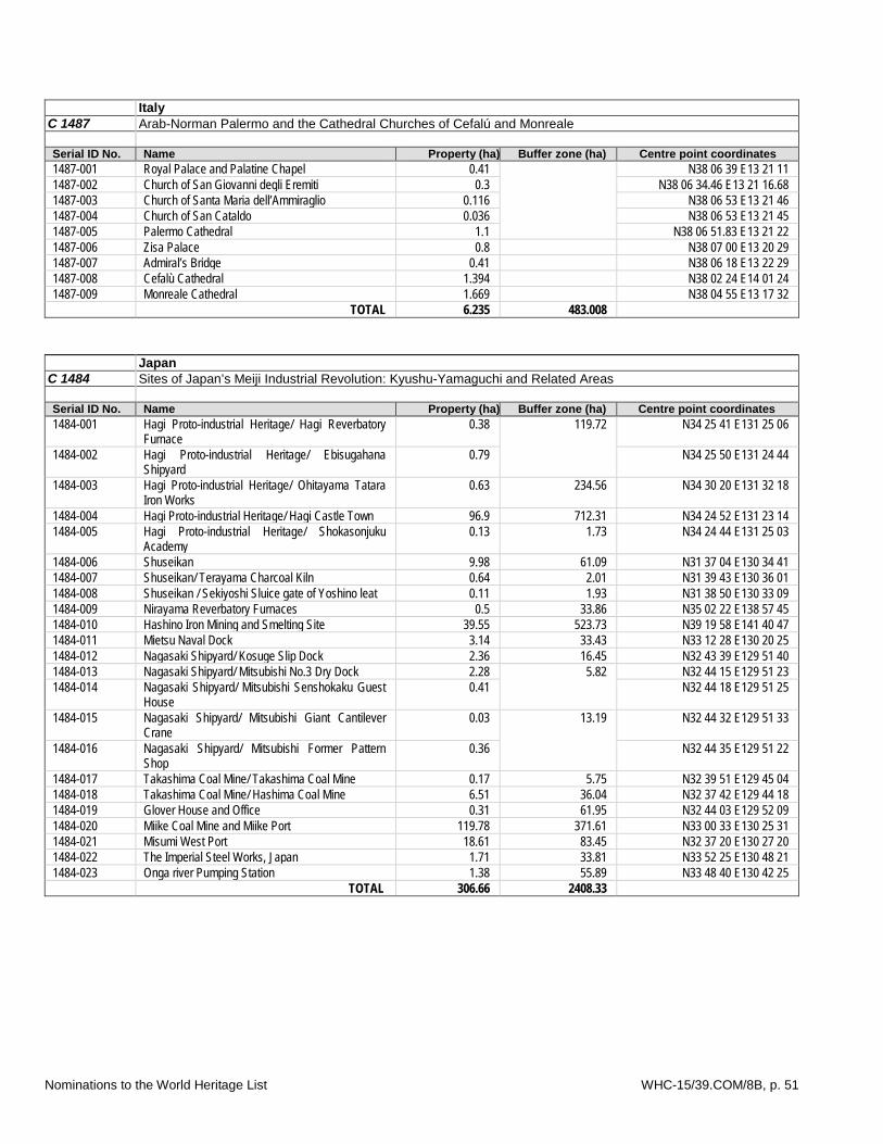
Italy C 1487 Arab-Norman Palermo and the Cathedral Churches of Cefalú and Monreale Serial ID No. Name Property (ha) Buffer zone (ha) Centre point coordinates 1487-001 Royal Palace and Palatine Chapel 0.41 N38 06 39 E13 21 11 1487-002 Church of San Giovanni degli Eremiti 0.3 N38 06 34.46 E13 21 16.68 1487-003 Church of Santa Maria dell’Ammiraglio 0.116 N38 06 53 E13 21 46 1487-004 Church of San Cataldo 0.036 N38 06 53 E13 21 45 1487-005 Palermo Cathedral 1.1 N38 06 51.83 E13 21 22 1487-006 Zisa Palace 0.8 N38 07 00 E13 20 29 1487-007 Admiral’s Bridge 0.41 N38 06 18 E13 22 29 1487-008 Cefalù Cathedral 1.394 N38 02 24 E14 01 24 1487-009 Monreale Cathedral 1.669 N38 04 55 E13 17 32 TOTAL 6.235 483.008
Japan C 1484 Sites of Japan’s Meiji Industrial Revolution: Kyushu-Yamaguchi and Related Areas Serial ID No. Name Property (ha) Buffer zone (ha) Centre point coordinates 1484-001 Hagi Proto-industrial Heritage/ Hagi Reverbatory
Furnace 0.38 119.72 N34 25 41 E131 25 06
1484-002 Hagi Proto-industrial Heritage/ Ebisugahana
Shipyard 0.79 N34 25 50 E131 24 44
1484-003 Hagi Proto-industrial Heritage/ Ohitayama Tatara Iron Works
0.63 234.56 N34 30 20 E131 32 18
1484-004 Hagi Proto-industrial Heritage/ Hagi Castle Town 96.9 712.31 N34 24 52 E131 23 14 1484-005 Hagi Proto-industrial Heritage/ Shokasonjuku
Academy 0.13 1.73 N34 24 44 E131 25 03
1484-006 Shuseikan 9.98 61.09 N31 37 04 E130 34 41 1484-007 Shuseikan/ Terayama Charcoal Kiln 0.64 2.01 N31 39 43 E130 36 01 1484-008 Shuseikan / Sekiyoshi Sluice gate of Yoshino leat 0.11 1.93 N31 38 50 E130 33 09 1484-009 Nirayama Reverbatory Furnaces 0.5 33.86 N35 02 22 E138 57 45 1484-010 Hashino Iron Mining and Smelting Site 39.55 523.73 N39 19 58 E141 40 47 1484-011 Mietsu Naval Dock 3.14 33.43 N33 12 28 E130 20 25 1484-012 Nagasaki Shipyard/ Kosuge Slip Dock 2.36 16.45 N32 43 39 E129 51 40 1484-013 Nagasaki Shipyard/ Mitsubishi No.3 Dry Dock 2.28 5.82 N32 44 15 E129 51 23 1484-014 Nagasaki Shipyard/ Mitsubishi Senshokaku Guest
House 0.41 N32 44 18 E129 51 25
1484-015 Nagasaki Shipyard/ Mitsubishi Giant Cantilever Crane
0.03 13.19 N32 44 32 E129 51 33
1484-016 Nagasaki Shipyard/ Mitsubishi Former Pattern Shop
0.36 N32 44 35 E129 51 22
1484-017 Takashima Coal Mine/ Takashima Coal Mine 0.17 5.75 N32 39 51 E129 45 04 1484-018 Takashima Coal Mine/ Hashima Coal Mine 6.51 36.04 N32 37 42 E129 44 18 1484-019 Glover House and Office 0.31 61.95 N32 44 03 E129 52 09 1484-020 Miike Coal Mine and Miike Port 119.78 371.61 N33 00 33 E130 25 31 1484-021 Misumi West Port 18.61 83.45 N32 37 20 E130 27 20 1484-022 The Imperial Steel Works, Japan 1.71 33.81 N33 52 25 E130 48 21 1484-023 Onga river Pumping Station 1.38 55.89 N33 48 40 E130 42 25 TOTAL 306.66 2408.33
Nominations to the World Heritage List WHC-15/39.COM/8B, p. 51

Republic of Korea C 1477 Baekje Historic Areas Serial ID No. Name Property (ha) Buffer zone (ha) Centre point coordinates 1477-001 Gongsanseong Fortress 20.31 21.02 N36 27 43 E127 07 38 1477-002 Royal Tombs in Songsan-ri 1.63 20.46 N36 27 47 E127 06 51
1477-003 Archeological Site in Gwanbuk-ri and Busosanseong Fortress 60.60 69.66 N36 17 23 E126 54 54
1477-004 Jeongnimsa Temple Site 1.52 6.57 N36 16 44 E126 54 48 1477-005 Royal Tombs in Neungsan-ri 2.10 26.50 N36 16 42 E126 56 39 1477-006 Naseong City Wall 24.52 93.17 N36 16 22 E126 56 25 1477-007 Archeological Site in Wanggung-ri 12.35 12.50 N35 58 30 E127 03 20 1477-008 Mireuksa Temple Site 12.07 53.76 N36 00 42 E127 01 51
TOTAL 135.10 303.64 Saudi Arabia C 1472 Rock Art in the Hail Region of Saudi Arabia Serial ID No. Name Property (ha) Buffer zone (ha) Centre point coordinates 1472-001 Jabal Umm Sinman 1783.9 1951 N28 0 38 E40 54 47 1472-002 Jabal al-Manjor and Jabal Raat 259.9 1658.5 N26 9 13 E39 53 30 TOTAL 2043.8 3609.5
Turkey C 1018 Rev Ephesus Serial ID No. Name Property (ha Buffer zone (ha) Centre point coordinates 1018rev-001 Cukurici Mound 1.50 1165.96 N37 55 45 E27 21 34 1018rev-002 Ancient city of Ephesus 546.28 N37 56 29 E27 20 26 1018rev-003 Ayasuluk Hill, Artemision and Medieval Settlement 36.33 N37 56 59 E27 21 50 1018rev-004 House of Virgin Mary 0.55 83 N37 54 42 E27 20 01 TOTAL 662.62 1248.96
Uganda C 1491 Nyero and other hunter-gatherer geometric rock art sites in eastern Uganda Serial ID No. Name Property (ha Buffer zone (ha) Centre point coordinates 1491-001 Nyero 13.673 67.142 N1 28 24 E33 50 40 1491-002 Dolwe Island 13.161 2624.707 S0 7 26 E33 40 14 1491-003 Mukongoro 8.444 23.732 N1 19 22 E33 52 59 1491-004 Komuge 1.511 3.724 N1 12 52 E34 05 26 1491-005 Kakoro 1.403 6.348 N1 10 42 E34 04 09 1491-006 Kapir 0.192 42.474 N1 39 33 E33 46 51 TOTAL 37.235 2768.127
United States of America C 1466 San Antonio Missions Serial ID No. Name Property (ha) Buffer zone (ha) Centre point coordinates 1466-001 Mission Espada 94.7 2068 N29 19 41 W98 27 36 1466-002 Mission San Juan 130.5 N29 19 56 W98 27 22 1466-003 Mission San José 20.6 N29 21 42 W98 28 48 1466-004 Mission Concepcion 13.3 N29 23 26 W98 29 32 1466-005 Mission Valero 1.7 N29 25 33 W98 29 09 1466-006 Rancho de las Cabras 40.0 -- N29 05 42 W98 10 00 TOTAL 300.8 2068
Nominations to the World Heritage List WHC-15/39.COM/8B, p. 52

Cultural sites - extensions
Spain C 669 Bis Routes of Santiago in Northern Spain Serial ID No. Name Property (km/ha) Buffer zone (ha) Centre point coordinates 669bis-001 Chemin Primitif 311.31 km 1903.55 N43 20 06 W6 24 53 669bis-002 Chemin de la Côte 936.28 km 5723.87 N43 20 18 W1 47 24 669bis-003 Chemin de l’Intérieur 196.00 km 1187.43 N43 18 34 W7 51 34 669bis-004 Chemin de la Liébana 55.32 km 330.44 N43 23 9 W4 23 53 669bis-005 Cathédrale San Salvador et Chambre Sainte 0.66 11.94 N43 21 45 W5 50 35 669bis-006 Eglise et Monastère de San Salvador 0.56 3.97 N43 24 32 W6 9 24 669bis-007 Cathédral de Lugo 0.50 2.60 N43 0 33 W7 33 29 669bis-008 Remparts Romains de Lugo 1.78 44.15 N43 0 36 W7 33 21 669bis-009 Collégiale de Ziortza 0.22 1.41 N43 14 52 W2 33 43 669bis-010 Cathédrale de Saint Jacques Apôtre 0.31 1.07 N43 15 25 W2 55 25 669bis-011 Eglise Santa Maria de la Asuncion 0.13 0.33 N43 23 4 W3 12 56 669bis-012 Collégiale de Santa Juliana et son Cloître 0.25 0.14 N43 23 32 W4 6 21 669bis-013 Eglise San Salvador 0.03 0.00 N43 29 6.9 W5 21 31.5 669bis-014 Eglise Santa Maria de Soto de Luina 0.06 3.46 N43 33 42 W6 13 49 669bis-015 Cathedrale de Mondonedo 0.29 3.10 N43 25 41 W7 21 45 669bis-016 Monaster de Sobrado Dos Monxes 6.71 37.16 N43 2 19 W8 1 20 669bis-017 Chaussée et Tunnel de San Adrian 2.53 23.05 N42 56 7 W2 19 0 669bis-018 Cathedrale de Vitoria-Gasteiz 0.25 2.69 N42 51 2 W2 40 20 669bis-019 Pont de Brinas sur le Fleuve Ebro 0.10 0.92 N42 35 21 W2 50 32 669bis-020 Monastère de Santo Toribio de Liébana 0.20 0.29 N43 9 W4 39 15 TOTAL 1498.91 km
14.58 ha
9281.57
Nominations to the World Heritage List WHC-15/39.COM/8B, p. 53