workshop on quantitative evaluation of downscaled c limate projections (august 12-16, 2013)
DESCRIPTION
The National Climate Predictions and Projections Platform. Workshop on Quantitative Evaluation of Downscaled C limate Projections (August 12-16, 2013). Motivation: Practitioner’s Dilemma. - PowerPoint PPT PresentationTRANSCRIPT
Workshop on Quantitative Evaluation of Downscaled
Climate Projections (August 12-16, 2013)
The National Climate Predictions and Projections Platform
Motivation: Practitioner’s Dilemma
• Practitioner’s dilemma - how to choose among many available sources of climate information for a given place and application?
Needs
• Objective evaluation of datasets prepared for use in planning for climate change.
• Provision of application-specific guidance to improve usability of climate-change projections in planning.
• Initiate a community based on standards to build and sustain practice of evaluation and informed use of climate-change projections.
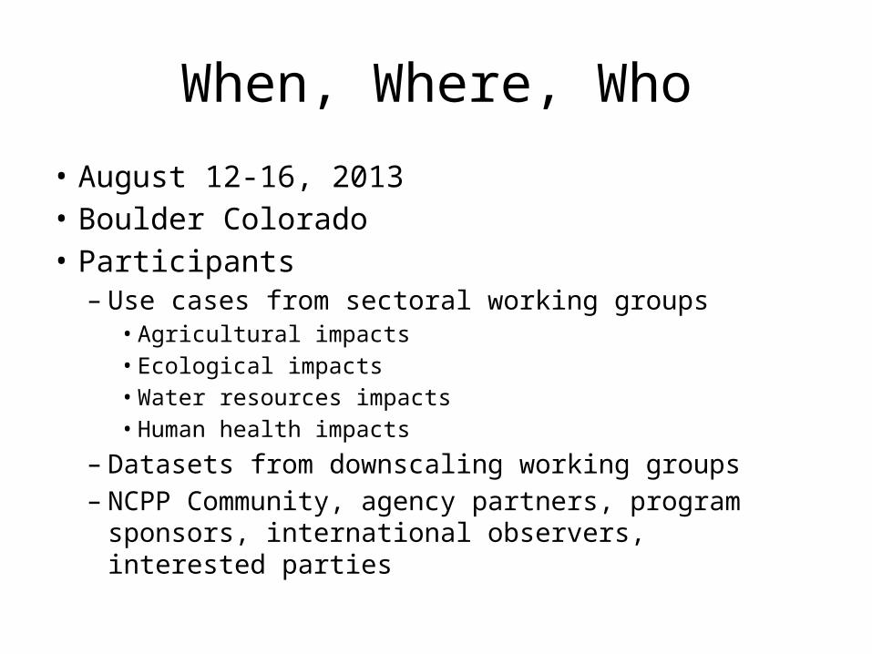
When, Where, Who
• August 12-16, 2013• Boulder Colorado• Participants
– Use cases from sectoral working groups• Agricultural impacts• Ecological impacts• Water resources impacts• Human health impacts
– Datasets from downscaling working groups– NCPP Community, agency partners, program
sponsors, international observers, interested parties
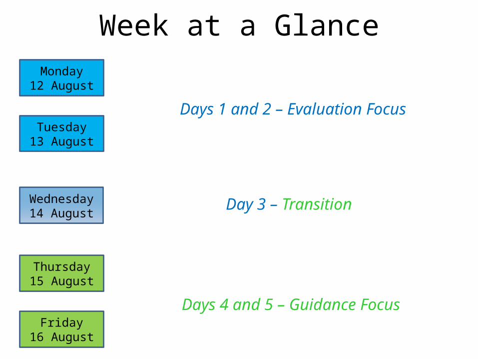
Week at a GlanceMonday
12 August
Tuesday13 August
Wednesday14 August
Thursday15 August
Friday16 August
Days 1 and 2 – Evaluation Focus
Day 3 – Transition
Days 4 and 5 – Guidance Focus
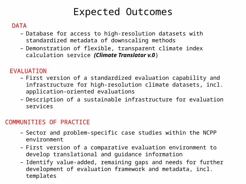
Expected Outcomes
– Database for access to high-resolution datasets with standardized metadata of downscaling methods
– Demonstration of flexible, transparent climate index calculation service (Climate Translator v.0)
– First version of a standardized evaluation capability and infrastructure for high-resolution climate datasets, incl. application-oriented evaluations
– Description of a sustainable infrastructure for evaluation services
– Sector and problem-specific case studies within the NCPP environment
– First version of a comparative evaluation environment to develop translational and guidance information
– Identify value-added, remaining gaps and needs for further development of evaluation framework and metadata, incl. templates
DATA
EVALUATION
COMMUNITIES OF PRACTICE
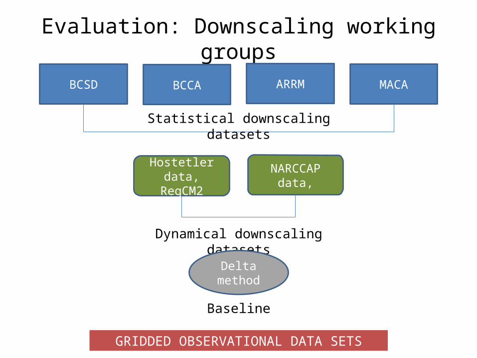
Evaluation: Downscaling working groups
BCSD BCCA ARRM MACA
Statistical downscaling datasets
Hostetler data, RegCM2
NARCCAP data,
Dynamical downscaling datasets
Delta method
Baseline
GRIDDED OBSERVATIONAL DATA SETS
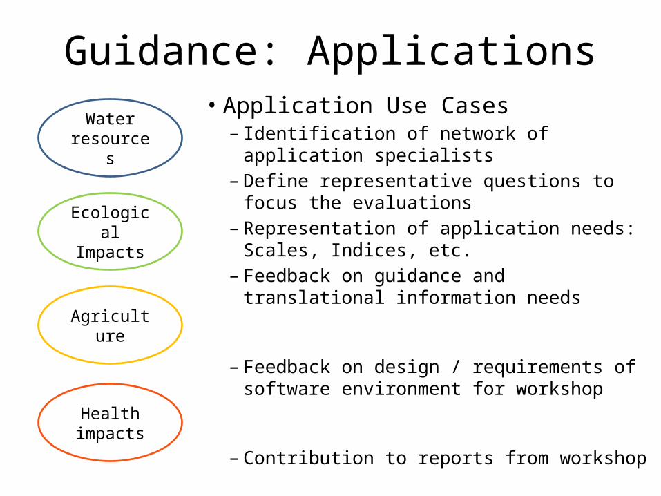
Guidance: Applications• Application Use Cases
– Identification of network of application specialists
– Define representative questions to focus the evaluations
– Representation of application needs: Scales, Indices, etc.
– Feedback on guidance and translational information needs
– Feedback on design / requirements of software environment for workshop
– Contribution to reports from workshop
Water resources
Ecological Impacts
Agriculture
Health impacts
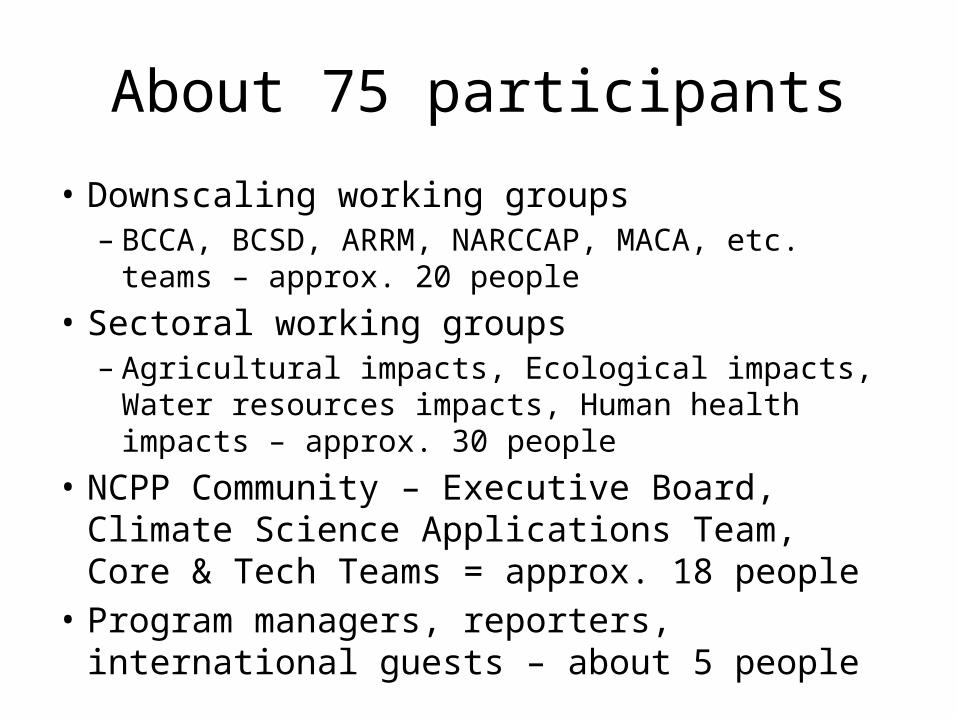
About 75 participants
• Downscaling working groups– BCCA, BCSD, ARRM, NARCCAP, MACA, etc. teams –
approx. 20 people
• Sectoral working groups– Agricultural impacts, Ecological impacts, Water
resources impacts, Human health impacts – approx. 30 people
• NCPP Community – Executive Board, Climate Science Applications Team, Core & Tech Teams = approx. 18 people
• Program managers, reporters, international guests – about 5 people
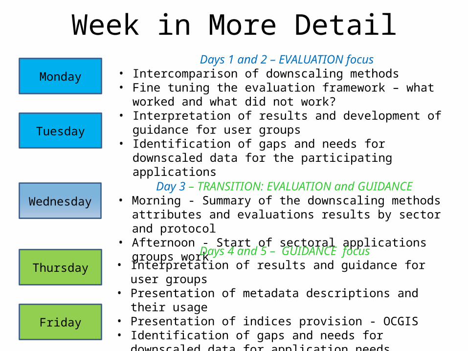
Week in More Detail
Monday
Tuesday
Wednesday
Thursday
Friday
Days 1 and 2 – EVALUATION focus• Intercomparison of downscaling methods• Fine tuning the evaluation framework – what worked and what did
not work?• Interpretation of results and development of guidance for user
groups• Identification of gaps and needs for downscaled data for the
participating applications
Day 3 – TRANSITION: EVALUATION and GUIDANCE• Morning - Summary of the downscaling methods attributes and
evaluations results by sector and protocol• Afternoon - Start of sectoral applications groups work
Days 4 and 5 – GUIDANCE focus• Interpretation of results and guidance for user groups• Presentation of metadata descriptions and their usage• Presentation of indices provision - OCGIS• Identification of gaps and needs for downscaled data for application
needs• Identification of future steps
Below are categories of supplemental information
Days in More Detail
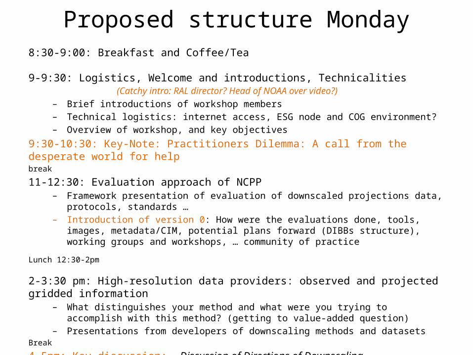
Proposed structure Monday8:30-9:00: Breakfast and Coffee/Tea
9-9:30: Logistics, Welcome and introductions, Technicalities (Catchy intro: RAL director? Head of NOAA over video?)
– Brief introductions of workshop members– Technical logistics: internet access, ESG node and COG environment? – Overview of workshop, and key objectives
9:30-10:30: Key-Note: Practitioners Dilemma: A call from the desperate world for helpbreak
11-12:30: Evaluation approach of NCPP– Framework presentation of evaluation of downscaled projections data, protocols, standards
… – Introduction of version 0: How were the evaluations done, tools, images, metadata/CIM,
potential plans forward (DIBBs structure), working groups and workshops, … community of practice
Lunch 12:30-2pm
2-3:30 pm: High-resolution data providers: observed and projected gridded information– What distinguishes your method and what were you trying to accomplish with this method?
(getting to value-added question)– Presentations from developers of downscaling methods and datasets
Break
4-5pm: Key discussion: Discussion of Directions of Downscaling
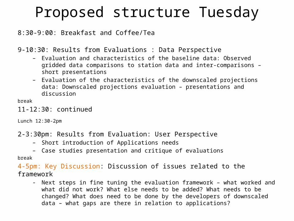
Proposed structure Tuesday8:30-9:00: Breakfast and Coffee/Tea
9-10:30: Results from Evaluations : Data Perspective– Evaluation and characteristics of the baseline data: Observed gridded data comparisons to
station data and inter-comparisons – short presentations – Evaluation of the characteristics of the downscaled projections data: Downscaled
projections evaluation – presentations and discussionbreak
11-12:30: continued
Lunch 12:30-2pm
2-3:30pm: Results from Evaluation: User Perspective– Short introduction of Applications needs– Case studies presentation and critique of evaluations
break
4-5pm: Key Discussion: Discussion of issues related to the framework- Next steps in fine tuning the evaluation framework – what worked and what did not work?
What else needs to be added? What needs to be changed? What does need to be done by the developers of downscaled data – what gaps are there in relation to applications?
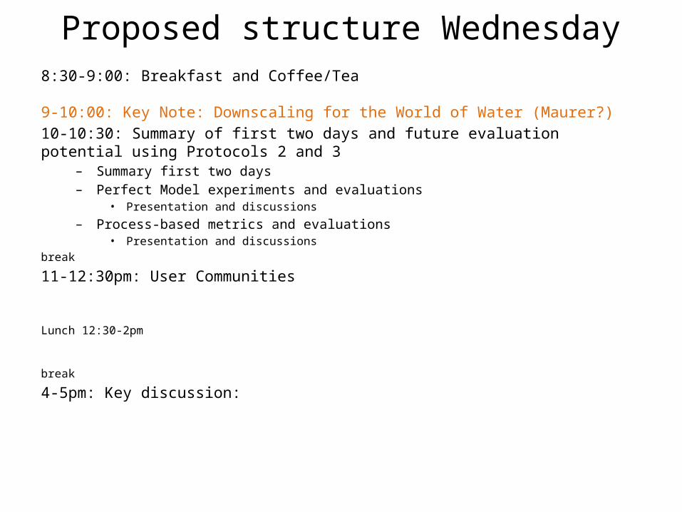
Proposed structure Wednesday8:30-9:00: Breakfast and Coffee/Tea
9-10:00: Key Note: Downscaling for the World of Water (Maurer?)
10-10:30: Summary of first two days and future evaluation potential using Protocols 2 and 3
– Summary first two days– Perfect Model experiments and evaluations
• Presentation and discussions
– Process-based metrics and evaluations• Presentation and discussions
break
11-12:30pm: User Communities
Lunch 12:30-2pm
break
4-5pm: Key discussion:
Day 4 and 5
More Detail on Participants and Partnerships
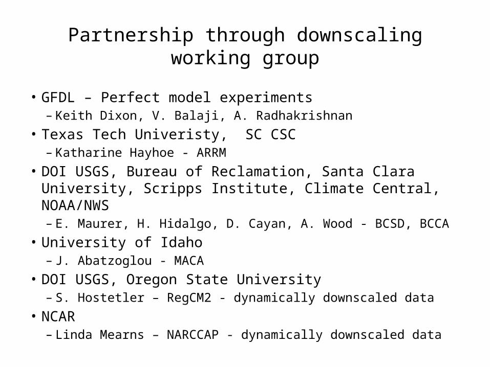
Partnership through downscaling working group
• GFDL – Perfect model experiments – Keith Dixon, V. Balaji, A. Radhakrishnan
• Texas Tech Univeristy, SC CSC– Katharine Hayhoe - ARRM
• DOI USGS, Bureau of Reclamation, Santa Clara University, Scripps Institute, Climate Central, NOAA/NWS– E. Maurer, H. Hidalgo, D. Cayan, A. Wood - BCSD, BCCA
• University of Idaho– J. Abatzoglou - MACA
• DOI USGS, Oregon State University– S. Hostetler – RegCM2 - dynamically downscaled data
• NCAR – Linda Mearns – NARCCAP - dynamically downscaled data
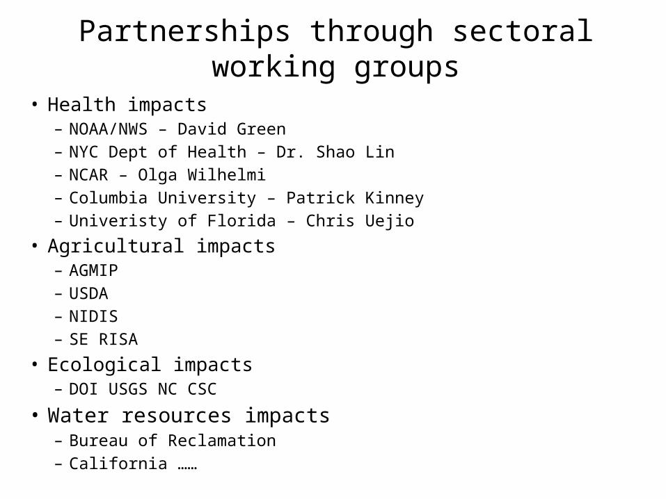
Partnerships through sectoral working groups
• Health impacts– NOAA/NWS – David Green– NYC Dept of Health – Dr. Shao Lin– NCAR – Olga Wilhelmi– Columbia University – Patrick Kinney– Univeristy of Florida – Chris Uejio
• Agricultural impacts– AGMIP – USDA– NIDIS – SE RISA
• Ecological impacts– DOI USGS NC CSC
• Water resources impacts– Bureau of Reclamation– California ……
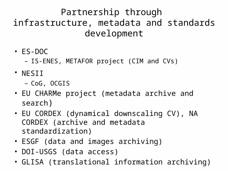
Partnership through infrastructure, metadata and standards development
• ES-DOC– IS-ENES, METAFOR project (CIM and CVs)
• NESII – CoG, OCGIS
• EU CHARMe project (metadata archive and search)• EU CORDEX (dynamical downscaling CV), NA
CORDEX (archive and metadata standardization)• ESGF (data and images archiving)• DOI-USGS (data access)• GLISA (translational information archiving)
More Details on Protocols and Metrics
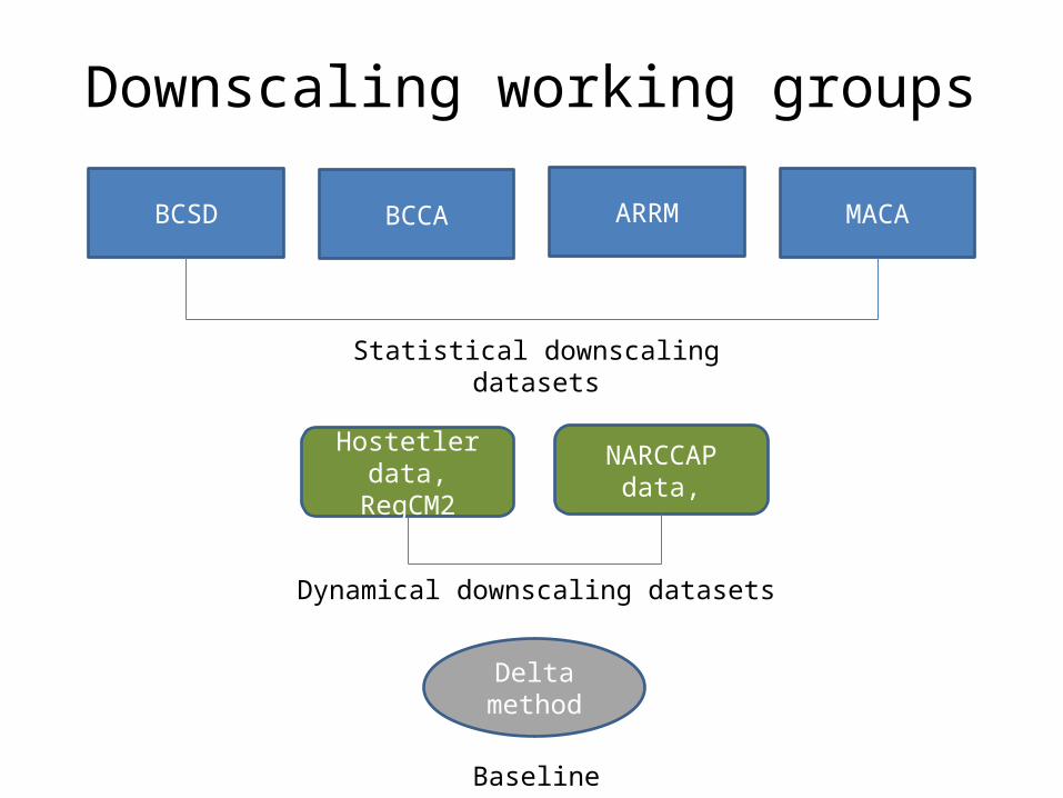
Downscaling working groups
BCSD BCCA ARRM MACA
Statistical downscaling datasets
Hostetler data, RegCM2
NARCCAP data,
Dynamical downscaling datasets
Delta method
Baseline
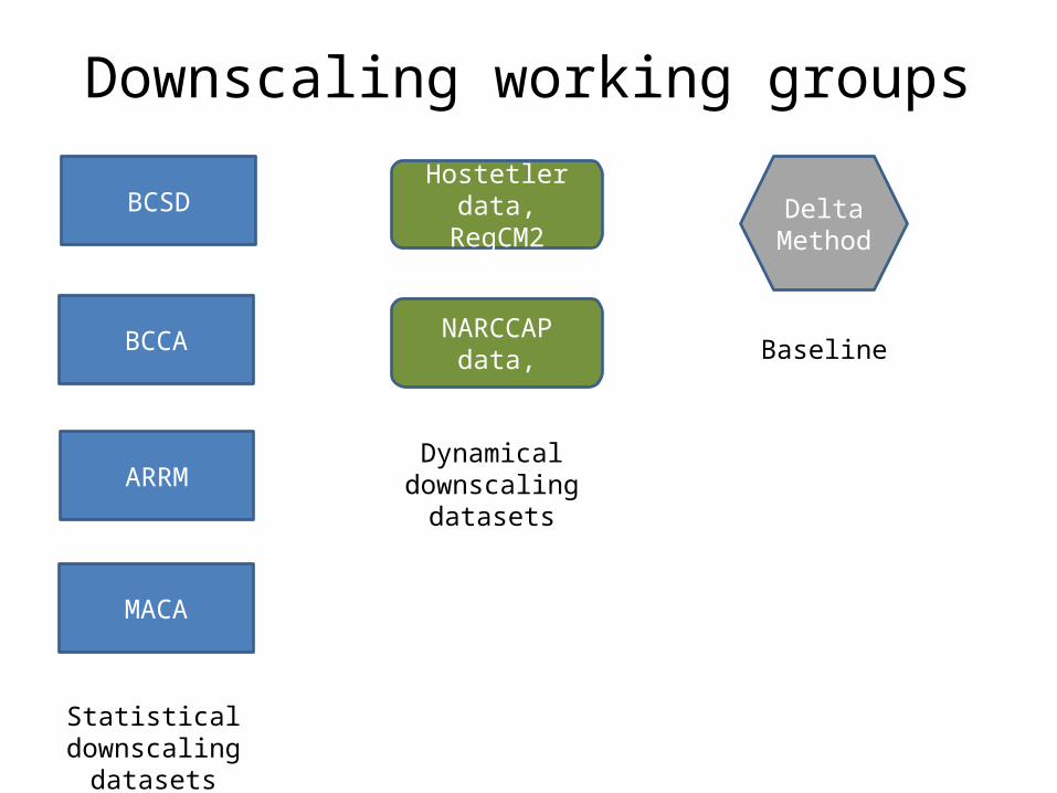
Downscaling working groups
BCSD
BCCA
ARRM
MACA
Statistical downscaling datasets
Hostetler data, RegCM2
NARCCAP data,
Dynamical downscaling
datasets
Baseline
Delta Method
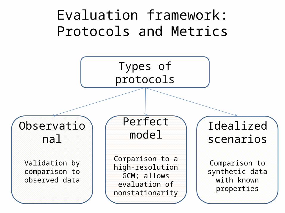
Types of protocols
Idealized scenarios
Comparison to synthetic data with known properties
Perfect model
Comparison to a high-resolution GCM; allows
evaluation of nonstationarity
Observational
Validation by comparison to observed data
Evaluation framework:Protocols and Metrics
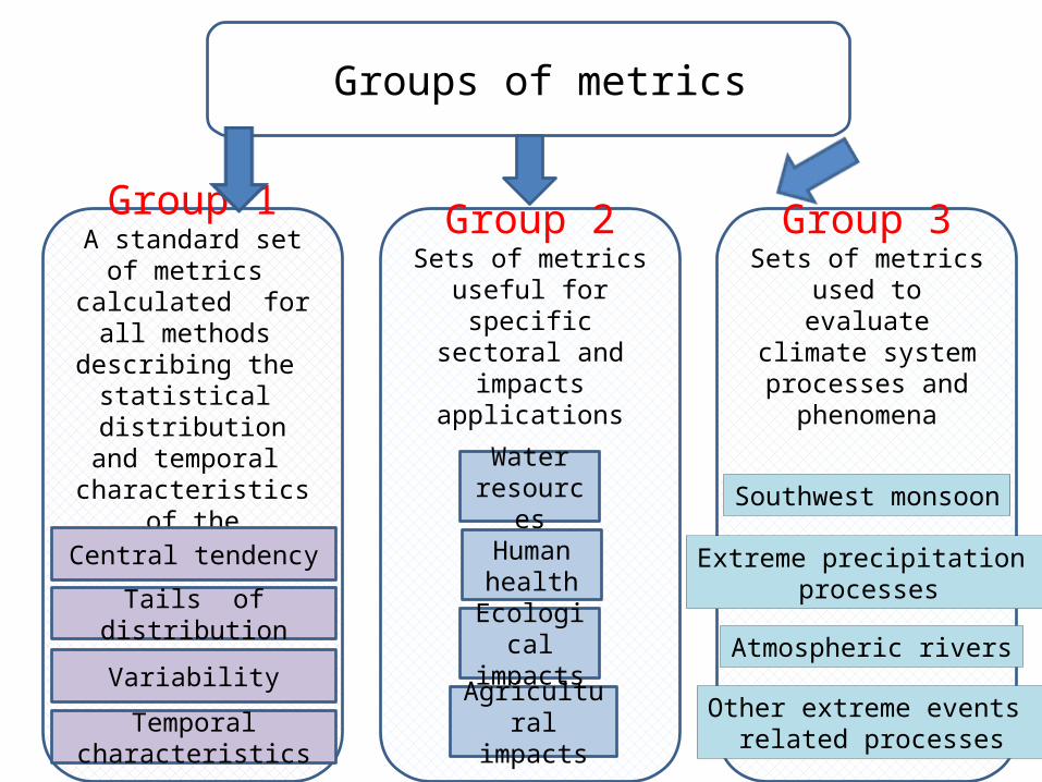
Groups of metrics
Group 2Sets of metrics useful for specific sectoral
and impacts applications
Water resources
Ecological impacts
Human health
Agricultural impacts
Group 1A standard set of
metrics calculated for all methods describing
the statistical distribution and
temporal characteristics of the
downscaled data
Central tendency
Tails of distribution
Variability
Temporal characteristics
Group 3Sets of metrics used to
evaluate climate system processes and
phenomena
Southwest monsoon
Extreme precipitation processes
Atmospheric rivers
Other extreme events related processes
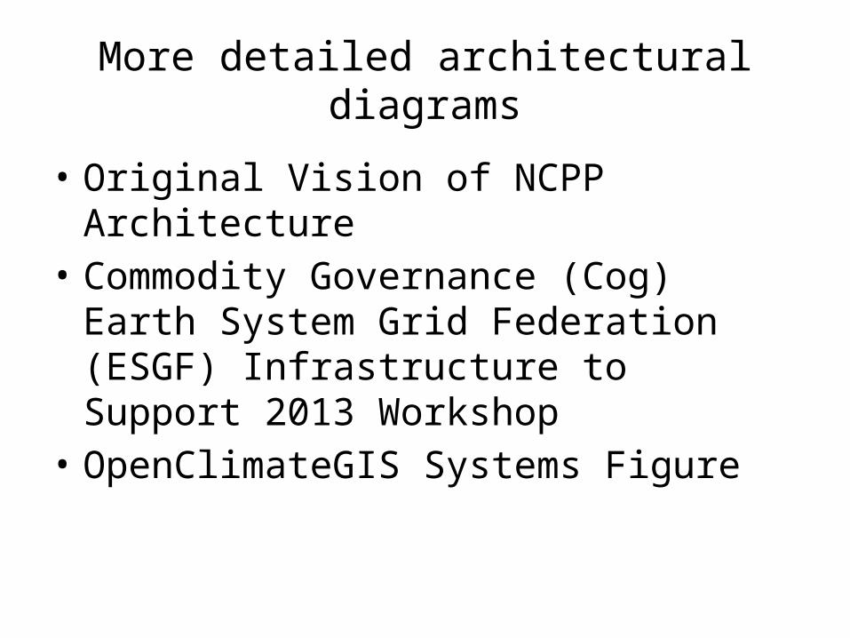
More detailed architectural diagrams
• Original Vision of NCPP Architecture• Commodity Governance (Cog) Earth
System Grid Federation (ESGF) Infrastructure to Support 2013 Workshop
• OpenClimateGIS Systems Figure
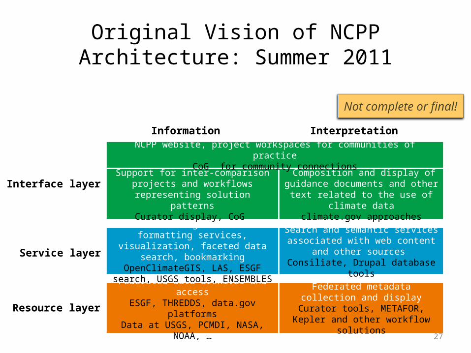
27
Federated data archival and accessESGF, THREDDS, data.gov platforms
Data at USGS, PCMDI, NASA, NOAA, …
Downscaling and data formatting services, visualization, faceted data search, bookmarkingOpenClimateGIS, LAS, ESGF search, USGS
tools, ENSEMBLES
Resource layer
Service layer
Support for inter-comparison projects and workflows representing solution patterns
Curator display, CoG
Interface layer Composition and display of guidance
documents and other text related to the use of climate data
climate.gov approaches
Search and semantic services associated with web content and other sources
Consiliate, Drupal database tools
Federated metadata collection and displayCurator tools, METAFOR, Kepler and other
workflow solutions
Information Interpretation
NCPP website, project workspaces for communities of practiceCoG for community connections
Not complete or final!
Original Vision of NCPP Architecture: Summer 2011
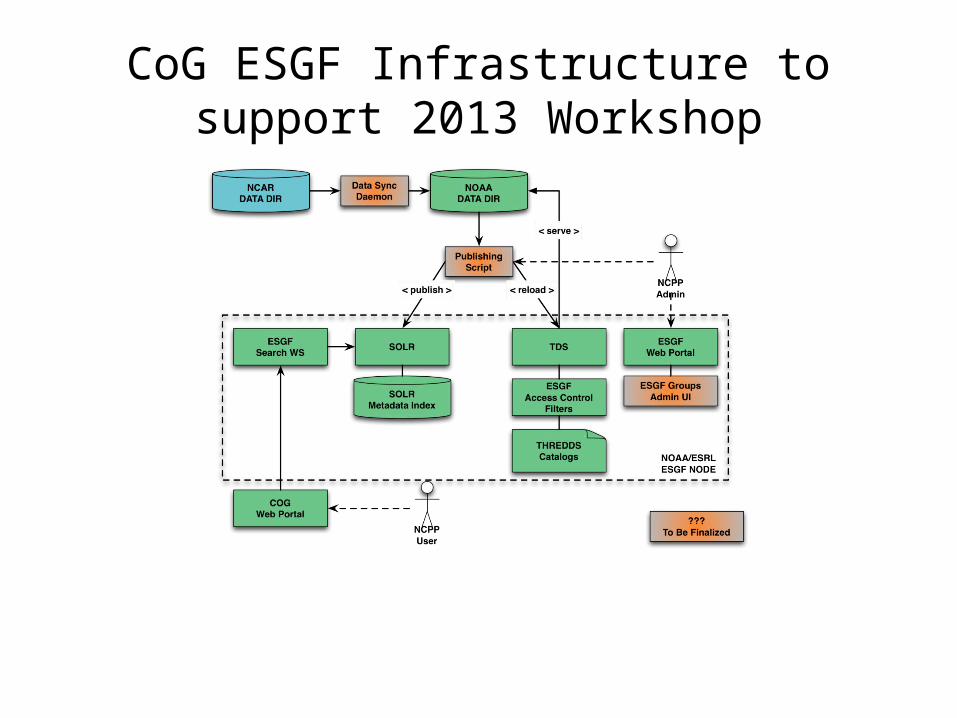
CoG ESGF Infrastructure to support 2013 Workshop
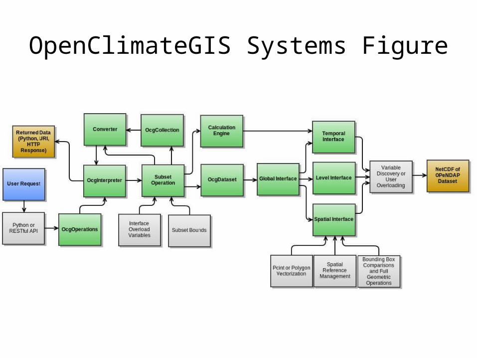
OpenClimateGIS Systems Figure
Design Considerations:Climate Translator V.0
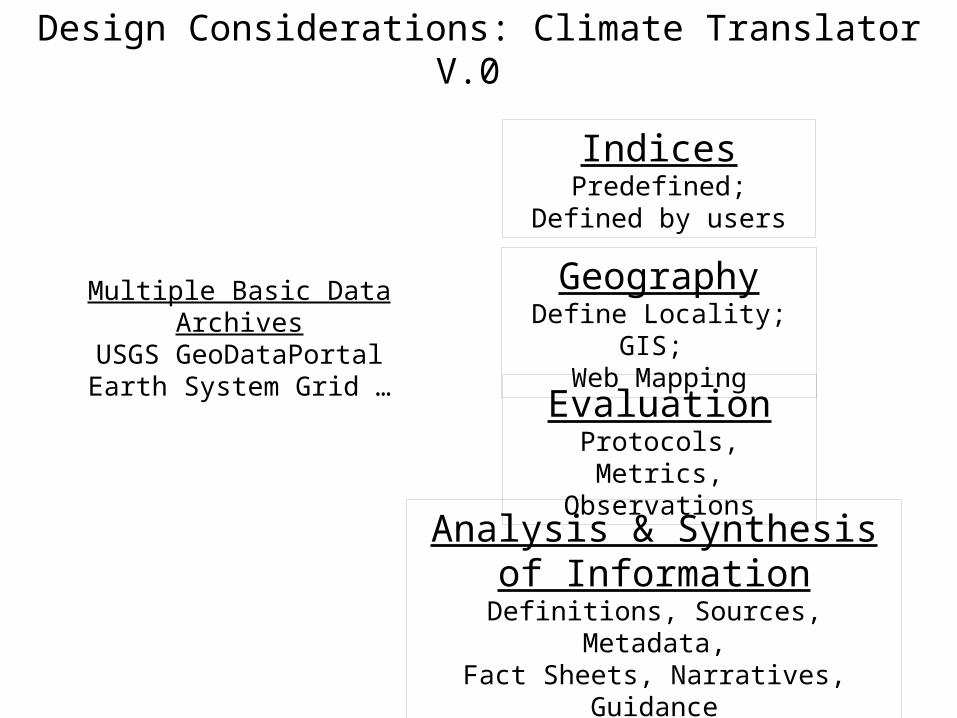
Design Considerations: Climate Translator V.0
IndicesPredefined; Defined by
users
GeographyDefine Locality; GIS;
Web Mapping
EvaluationProtocols, Metrics,
Observations
Analysis & Synthesis of Information
Definitions, Sources, Metadata,Fact Sheets, Narratives, Guidance
Multiple Basic Data ArchivesUSGS GeoDataPortalEarth System Grid …
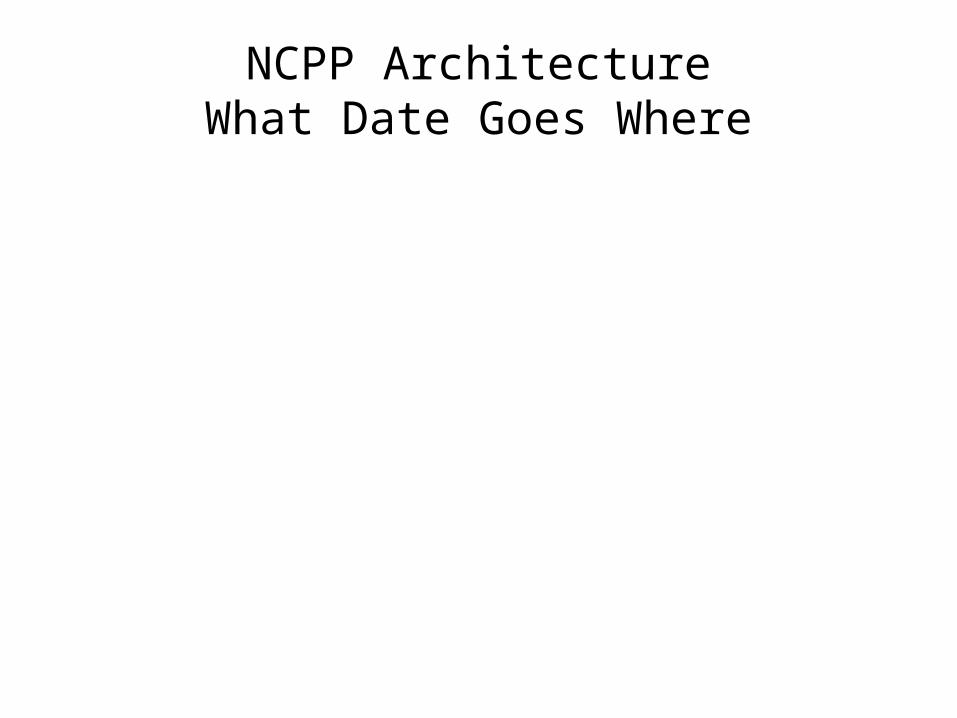
NCPP ArchitectureWhat Date Goes Where
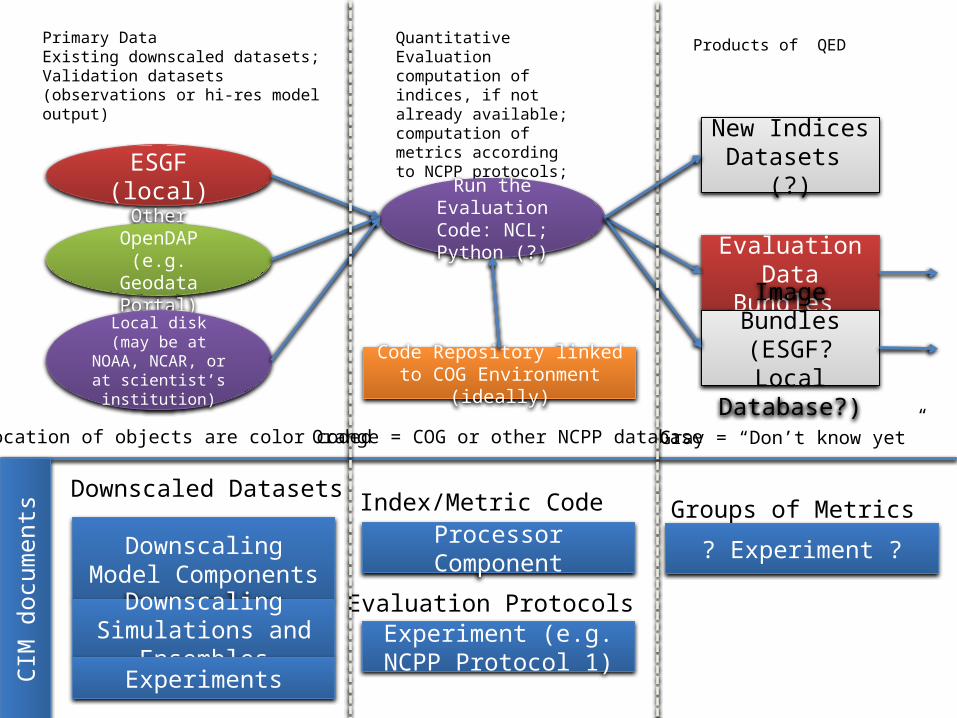
Primary DataExisting downscaled datasets; Validation datasets (observations or hi-res model output)
Quantitative Evaluation computation of indices, if not already available; computation of metrics according to NCPP protocols;
ESGF (local)
Other OpenDAP (e.g. Geodata
Portal)
Local disk (may be at NOAA, NCAR, or at
scientist’s institution)
Run the Evaluation Code: NCL; Python (?)
Evaluation Data Bundles
Image Bundles(ESGF? Local Database?)
Downscaling Model Components
Downscaling Simulations and Ensembles
Experiments
Processor Component
Index/Metric CodeDownscaled Datasets
Evaluation Protocols Experiment (e.g. NCPP
Protocol 1)
Groups of Metrics
? Experiment ?
Products of QED
Code Repository linked to COG Environment (ideally)
CIM
doc
umen
ts
New Indices Datasets (?)
Location of objects are color coded Orange = COG or other NCPP database Gray = “Don’t know yet”
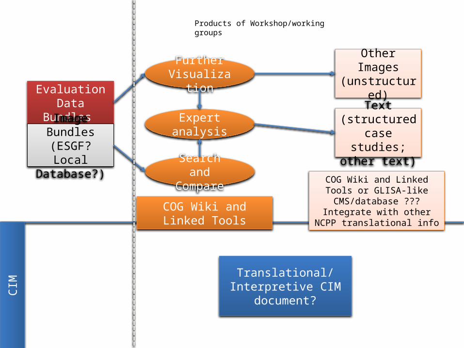
Expert analysis
Evaluation Data Bundles
Image Bundles(ESGF? Local Database?)
Text (structured case studies; other text)
Products of Workshop/working groups
Search and Compare
Further Visualization
Other Images (unstructured)
Translational/Interpretive CIM document?
COG Wiki and Linked Tools
CIM
COG Wiki and Linked Tools or GLISA-like CMS/database ???
Integrate with other NCPP translational info
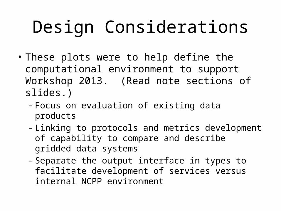
Design Considerations
• These plots were to help define the computational environment to support Workshop 2013. (Read note sections of slides.)– Focus on evaluation of existing data products– Linking to protocols and metrics development of
capability to compare and describe gridded data systems
– Separate the output interface in types to facilitate development of services versus internal NCPP environment
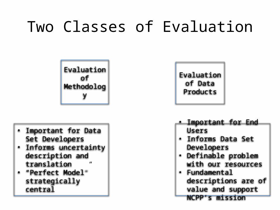
Two Classes of Evaluation
Evaluation of Methodology
Evaluation of Data Products
• Important for Data Set Developers
• Informs uncertainty description and translation
• “Perfect Model” strategically central
• Important for End Users• Informs Data Set
Developers• Definable problem with our
resources• Fundamental descriptions
are of value and support NCPP’s mission
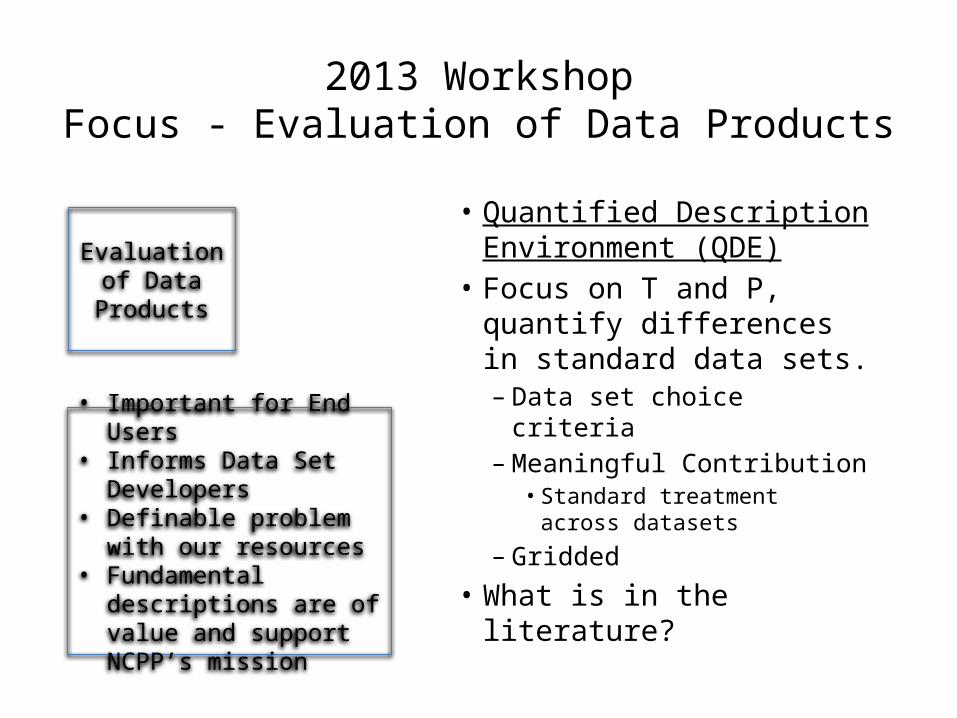
2013 WorkshopFocus - Evaluation of Data Products
• Quantified Description Environment (QDE)
• Focus on T and P, quantify differences in standard data sets.– Data set choice criteria– Meaningful Contribution
• Standard treatment across datasets
– Gridded
• What is in the literature?
Evaluation of Data Products
• Important for End Users• Informs Data Set
Developers• Definable problem with our
resources• Fundamental descriptions
are of value and support NCPP’s mission
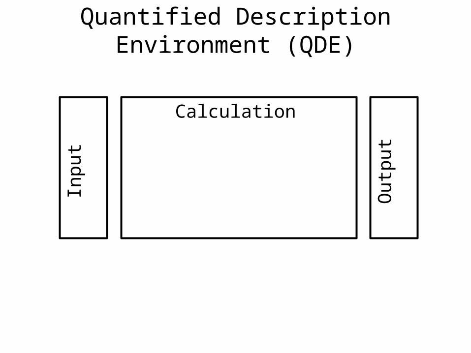
Quantified Description Environment (QDE)
Calculation
Inpu
t
Out
put
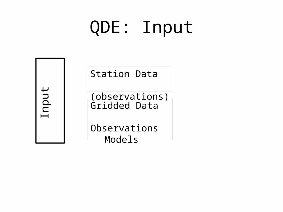
QDE: InputIn
put
Station Data (observations)
Gridded DataObservationsModels
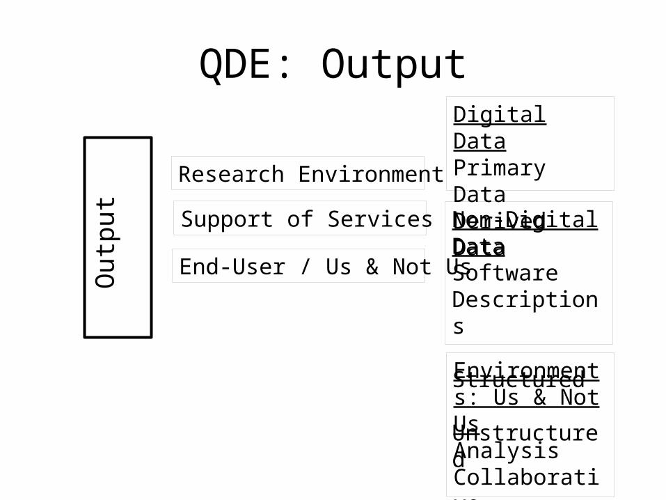
QDE: OutputO
utpu
t
Research Environment
Support of Services
End-User / Us & Not Us
Digital DataPrimary DataDerived Data
Non-Digital DataSoftwareDescriptions Structured Unstructured
Environments: Us & Not UsAnalysisCollaborativeEnd-user
2013 Workshop and NCPP
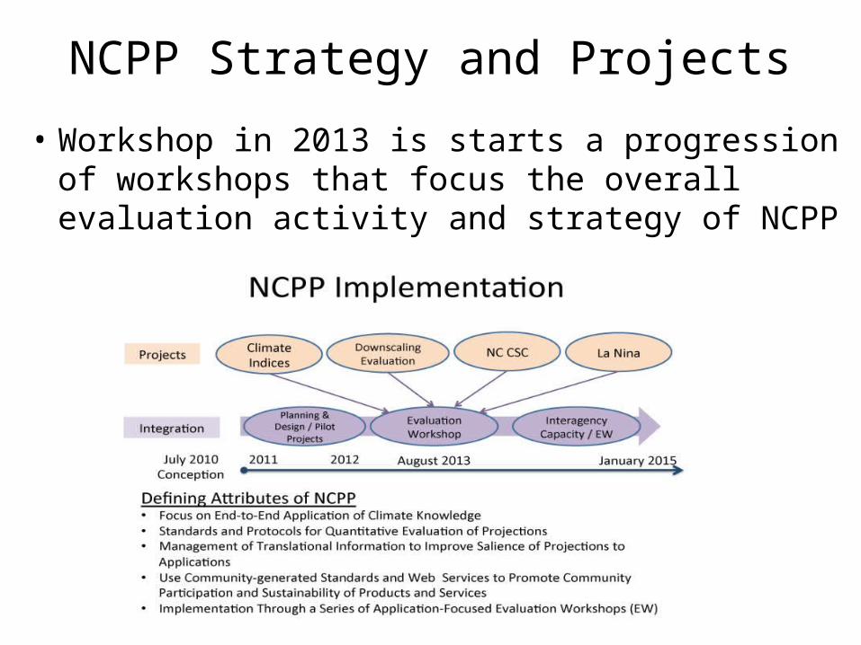
NCPP Strategy and Projects
• Workshop in 2013 is starts a progression of workshops that focus the overall evaluation activity and strategy of NCPP
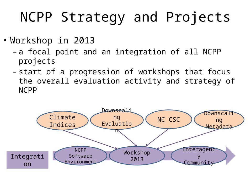
NCPP Strategy and Projects
• Workshop in 2013– a focal point and an integration of all NCPP projects– start of a progression of workshops that focus the
overall evaluation activity and strategy of NCPP
Climate Indices
Downscaling Evaluation
NC CSC Downscaling Metadata
IntegrationWorkshop
2013NCPP Software Environment
Interagency Community
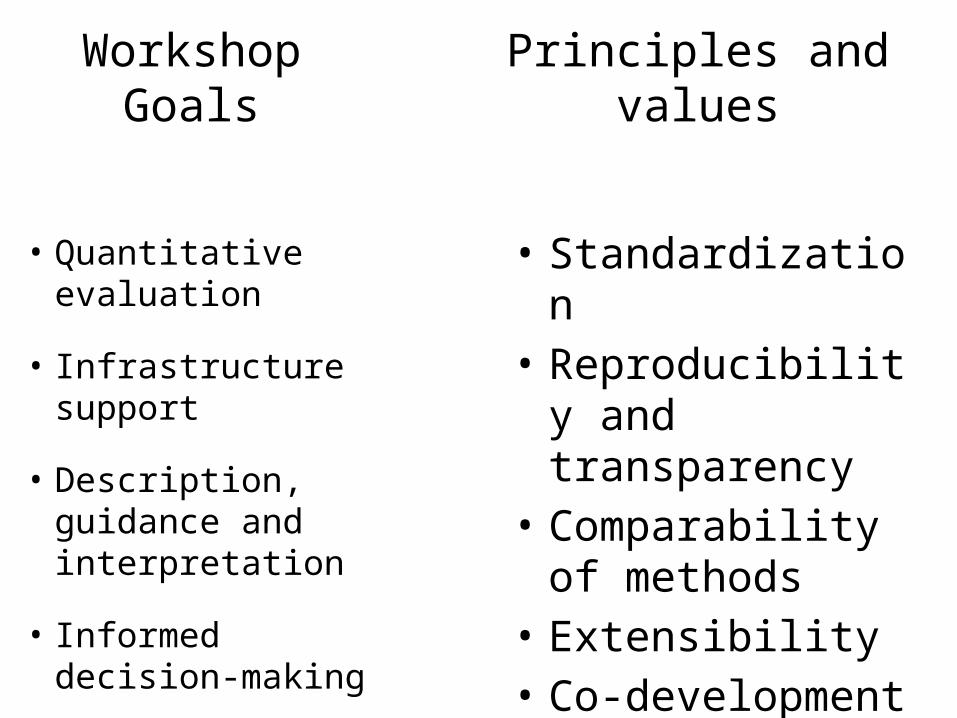
Workshop Goals
• Quantitative evaluation
• Infrastructure support
• Description, guidance and interpretation
• Informed decision-making
Principles and values
• Standardization • Reproducibility and
transparency • Comparability of
methods• Extensibility • Co-development
Contributions to NCPP development goals
I. Evaluation standards– Develop a suite of evaluation metrics for downscaled data– Design a common suite of tests to evaluate downscaling methods
II. Guidance documents– Produce guidance on the advantages and limitations of various downscaling
techniques for specific user applications based on the quantitative evaluations– Inform development of standard, vetted downscaled climate prediction and projection
products
III. Translation for users and development of metadata– Educate users in the evaluation and application of downscaled climate prediction and
projection products– Develop searchable structured metadata to describe downscaling methods as well as
their evaluations– Develop an initial platform for data discovery, exploration, and analysis that serves and
makes use of the translational information
IV. Cyber infrastructure – Develop information technology infrastructure to support community analysis and
provision of climate information.