woburn segment 5, alfred to school streets
TRANSCRIPT

Segment Five:
Alfred Street to School StreetWoburn, Massachusetts
ofThe Middlesex Canal Restoration Program Study
prepared by
T h e W a t e r f i e l d D e s i g n G r o u p , I n c .50 Cross Street Winchester Massachusetts 01890 USA
May 2008
prepared for
The Middlesex Canal Commission
Bicycle & Walking Paths Concept Study


Segment Five: Alfred Street to School Street
LinscottLinscottElementary Elementary SchoolElementary SchoolElementary
1790 House1790 House
Baldwin HouseBaldwin House


Project Goals
At the request of the Middlesex Canal Commission and the City of Woburn, Waterfi eld Design Group Inc. has studied the canal and the abandoned railroad as possible historic reclamation sites from Alfred Street to School Street in Woburn Massachusetts.
Based upon meetings with the Canal Commissionand the City of Woburn, the goal of developingthis segment has two elements. First will bedeveloping the canal’s towpath as a walking pathwhile fi nding unique ways to restore and preserve the Canal cross section. Second, the creation of a paved asphalt bike path will utilize the abandonedrailroad bed and preserve the historic competition and ultimate replacement of the canal by the railroad.
Situated adjacent to the Baldwin Mansion, 1790House, Woburn’s Kiwanis Park, and with a connection to Ferullo Field this project will providefor over 10 acres of outdoor recreation for the residents of Woburn and visitors to the site.
The restoration of the canal can be coupled with the opportunity to highlight the historical signifi cance of the surrounding community while providing public access and preserving an existing wildlife habitat.
Opportunities to incorporate interpretive features like the ruins of the stone abutments of Baldwin’s Bridge, the holding basin, and the placement of informative and interpretive signs will be investigated. The creation of an “English Garden” at the Kiwanis Park location could serve to bring back the image of the era when the Middlesex Canal was the major transportation route for material goods from Boston to New Hampshire and an engineering marvel of its day.
Segment Five: Alfred Street to School Street
Illustration of the English Garden with the Baldwin Mansion in the background
The Baldwin Mansion today
The Middlesex Canal RestorationBicycle & Walking Paths Concept Study
The Waterfi eld Design Group | 1

The Alfred Street to School Street segment consists of approximately 2,560 feet of wet canal. Flowing south to north, the canal operates as a drainage channel with fl ow from upstream segments of the canal as well as contribution from the immediate area.
The southern terminus of the segment begins at Alfred Street between the Woburn Kiwanis Park and the Baldwin Mansion. Beginning just north of the Baldwin Mansion, the towpath and the railroad right-of-way run parallel with the canal to School Street. The tow-path is in good condition with some minor vegetative overgrowth. The railroad right-of-way has much more vegetation and some large diameter trees which make it more diffi cult to traverse.
The west bank of the canal is heavily vegetated. Locat-ed just north of the Kiwanis Park and the 1790 House, the bank becomes extremely wet. This area served as a
holding pond during the years of the canal’s operation. It has since fi lled with sediment and is largely now a wetland. The remaining portions of the west bank have a consistent slope up from the canal’s edge leveling off approximately 20 from the water surface. This slope makes travel along the water’s edge diffi cult. A nar-row gravel path is located at the top of the slope. This path traverses along the canal route behind the Roman Catholic Church ending at the Ferullo Field baseball park.
Ownership of the canal varies. For the majority of the segment, ownership is split down the center of the ca-nal. Almost the entire east bank of the canal is owned by the City of Woburn with the exception being the site of the Baldwin Mansion (currently utilized as a Chinese food restaurant). At this location, the towpath and canal to the centerline, is owned by the restaurant pro-prietor. The west bank is divided into four parcels with
Existing Conditions Summary
Segment Five: Alfred Street to School Street
2 | The Waterfi eld Design Group
Kiwanis Park owned by the City of Woburn
Baldwin Mansion & Property owned by Xiao Yi Duan
1790 House owned by the Woburn Daily Times
Wetland AreaHolding Basin
Baldwin Bridge Ruins

three ownership groups. The City of Woburn owns the parcels at either end of the segment, Kiwanis Park to the south and Ferullo Field to the north. Between these two parcels is prop-erty owned by the Woburn Daily Times (site of the 1790 House) and the Roman Catholic Church (St. Anthony’s Church).
The Waterfi eld Design Group | 3
St Anthony’s Church & Property owned by Roman Catholic Archdiocese
Ferullo Field owned by the City of Woburn
Railroad Right-of-Way owned by the City of Woburn
Middlesex Canal
Proposed Subdivision Property Line
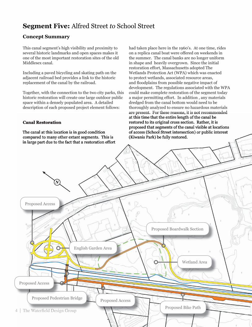
Concept Summary
Segment Five: Alfred Street to School Street
This canal segment’s high visibility and proximity to several historic landmarks and open spaces makes it one of the most important restoration sites of the old Middlesex canal.
Including a paved bicycling and skating path on the adjacent railroad bed provides a link to the historic replacement of the canal by the railroad.
Together, with the connection to the two city parks, this historic restoration will create one large outdoor public space within a densely populated area. A detailed description of each proposed project element follows:
Canal Restoration
The canal at this location is in good condition compared to many other extant segments. This is in large part due to the fact that a restoration effort
had taken place here in the 1960’s. At one time, rides on a replica canal boat were offered on weekends in the summer. The canal banks are no longer uniform in shape and heavily overgrown. Since the initial restoration effort, Massachusetts adopted The Wetlands Protection Act (WPA) which was enacted to protect wetlands, associated resource areas, and fl oodplains from possible negative impact of development. The regulations associated with the WPA could make complete restoration of the segment today a major permitting effort. In addition , any materials dredged from the canal bottom would need to be thoroughly analyzed to ensure no hazardous materials are present. For these reasons, it is not recommended are present. For these reasons, it is not recommended at this time that the entire length of the canal be restored to its original cross section. Rather, it is proposed that segments of the canal visible at locations of access (School Street intersection) or public interest (Kiwanis Park) be fully restored.
4 | The Waterfi eld Design Group
Proposed Boardwalk Section
Wetland Area
4 | The Waterfi eld Design Group
Proposed Pedestrian Bridge
Proposed Bike Path
Proposed Access
Proposed Access
Proposed Access
English Garden Area

The Waterfi eld Design Group | 5
Proposed Restored Towpath
Proposed Pedestrian Bridge
Proposed Access
Proposed Access

Restoration at these locations would involve accurately recreating the canal cross section. At areas visible from intersection streets, 100’ restoration sections are recommended to provide a visual element for the passerby. At locations such as the Kiwanis Park, the canal along its entire length would be proposed for restoration.
Towpath Restoration
The existing towpath is in relatively good condition. Periodic maintenance takes place to clear vegetation from the travel way and it appears that gravel and wood chips are spread to protect the surface. It is proposed that the entire surface would be replaced with a dense graded crushed stone or pea stone material. It is intended that this path would be used mainly by foot traffi c (no commuter bicycles, roller blades etc.).
In addition, the majority of all vegetation between thetowpath and the canal would be cleared to recreate as bestas possible, the original look of the canal.
Bike Path Creation
Utilizing the un-restored and overgrown abandoned railroad bed, a paved bicycle path will be created. Connecting Alfred Street and School Street this path will be ideal for local bicycle commuters wishing to avoid the traffi c of Main Street. It will also provide access for intermediate cyclists and families wanting to explore the historical landscape of Woburn.
Recreational Loop Creation
Enlarging and expanding portions of an existing path located on the west side of the canal it is proposed that a recreational loop be created. This loop, consisting of a stone dust path along the west side of the canal, would connect to the existing towpath and railroad bed bike path through the use of two pedestrian bridges, one at each end of the canal segment. It is recommended that the bridge at the southern end of the segment be constructed to replicate the rudimentary type design that is depicted on historic renderings of the area. This bridge would be a visual cornerstone to the park improvements recommended at the Kiwanis Park. The second pedestrian bridge would be located at the northern end of the project in the vicinity
of Ferullo Park. As this bridge would be less visible, a more economical design could be chosen. Portions of the proposed path on the west bank are located on private property and access/maintenance easements will need to be obtained in order to complete the construction.
It should be noted that even without the acquisition ofeasement over private land to complete the “looped”path, the inclusion of both pedestrian bridges is stillrecommended as it will provide connection to the Kiwanispark and the baseball fi eld. Both these element help tocomplete this project as a major open space public park.
Improvements to Ferullo Field
An important factor necessary for the success of the projectwill be access. Limited space is available for visitors ofthe canal to park and enjoy its amenities. Review of theexisting parking facilities at Ferullo Field indicated that thespace available to the City may be currently under utilized.In addition to the unconventional parking layout which exists along Main Street, a signifi cant amount of land is being encroached upon by an abutting automobile garage/junk yard. If this area were to be reclaimed by the City, ample space would be available to create a generous amount of parking for visitors to the canal and ballpark alike. In addition, improvements to the existing facility parking should be evaluated to determine if a more effi cient use of the current parking area presents itself.
English Garden
At the site of the Kiwanis Park, it is proposed that signifi cant landscape improvements be incorporated into the site including walkways, trees, a fountain, and other plantings. The desired result would be the creation of an “English Garden” that once existed near the current park’s location.
6 | The Waterfi eld Design Group

The Waterfi eld Design Group | 7
Kiwanis Park Rendering with English Garden
Existing Towpath
Existing Railroad BedExisting Railroad Bed

8 | The Waterfi eld Design Group

CHALLENGE #1: Parcel Ownership
The majority of the canal along this segment is owned by the City of Woburn and is to be the focus of the plans. In addition, the following properties will be incorporated into the plans with the specifi c agreement of the responsible City departments:
• Railroad Right of Way • Kiwanis Park
• Ferullo Field
Three lots abutting the westerly side of the canal and one abutting the southern side of the canal lot will need the written approval of the private owners,.specifi cally as follows:
• Defi ned easement • Right to construct paths and amenities • Right to public access and use of the area. • All rights need to be perpetual
Before the design of the pathways can proceed, these easements and appropriate rights must be fi nalized.
CHALLENGE #2: Access at Pedestrian Locations
Construction of the recreational loop with towpath reconstruction, bike path, and English Garden will require access for pedestrian visitors. Below is a list of the access points to the canal and paths from pedestrian locations, areas where access maybe a challenge are in bold:
• Ferullo Field • Sidewalk along School Street • Sidewalk along Main Street • Baldwin Mansion Parking Lot
It will need to be determined who is responsible for the access and maintenance of the sidewalk along Main Street as it is a sidewalk along State Highway 38. This will need to be determined and permission will need to be granted to the City in order for the English Garden pathways to access the sidewalk.
Permission would be needed from the owners of the
Baldwin Mansion for pedestrians to cross their parking lot to access the paths along the canal from Alfred Street.
Before the design of the pedestrian access ways were to go any further permission would need to grant from the appropriate responsible agencies.
CHALLENGE #3: Access for Automobile Parking
Construction of the recreational loop with towpath reconstruction, bike path, and English Garden will require access for automobiles to park. Below is a list of the access points to the canal and paths from parking locations, areas where access maybe a challenge, are in bold:
• Ferullo Field • Off of School Street • Baldwin Mansion Parking Lot
It will need to be determined what Xiao Yi Duan, the owner of the Baldwin Mansion, will allow for automobile access to the canal and associated paths. Questions that will need to be answered include:
• Will canal visitors be allowed to park in the restaurant parking lot?
• Will there be spaces marked off for canal visitors?
• If canal visitors are not allowed to park in the restaurant parking lot will restaurant patrons be allowed to park and visit the canal before or after their visit to the restaurant?
• Will there be fences and/or signs delineating the entrance and existence of the canal and pathways on the restaurant’s property?
It will also need to be determined to what extent the City of Woburn would allow the Ferullo Field parking lot to be reconstructed to accommodate visitors.
Before the design of the pathways were to go any further these questions would need to be answered to the satisfaction of the Commission and the City
Summary of Restoration Challenges
Segment Five: Alfred Street to School Street
The Waterfi eld Design Group | 9

10 | The Waterfi eld Design Group
CHALLENGE #4: English Garden
The English Garden, although it proposes signifi cantimprovements to the site, through recreating the historic characteristic of the landscape and enhancing the historic atmosphere of the district, it also proposes a challenge in the responsibility of its creation and maintenance. Before the design of the English Garden were to go any further these questions would need to be answered to the satisfaction of the Commission and the City.
Summary of Restoration Items
ITEM #1: Path Construction(towpath, bike and recreational path)
Construction of the easterly side of the canal willmostly be clearing and grubbing. The entire lengthof the towpath is clear of any major debris with someovergrown vegetation. Most of the railroad bed is clearwith the exception of some trees around the edges andone problem area that will need some excavation workand brush clearing.
Pedestrian crossings for the canal are needed. The fi rstcrossing will be at the Kiwanis Park and the other willbe at the northern end near the drainage swale.The westerly side of the canal has a couple of areas thatwill need some path clearing. The fi rst area to thenorth near the existing drainage swale will need a pathcut out to the baseball fi eld and the other area willbe for a path to go around existing wetlands towardsthe 1790 House. Excavation and tree removal will beneeded in these areas. In addition, construction of anelevated boardwalk may be necessary to reduce anypotential impacts to the wetlands at this area.
ITEM #2: Wetlands
Even though the Middlesex Canal is manmade, undercurrent regulations it maybe considered a wetland. Ifthat is the case, then a wetland permit is required bythe state.
ITEM #3: Canal Clearing
For aesthetic reasons, the canal waterway and the surrounding land should be cleared of any debris, such asfallen trees, trash, and overgrown vegetation.
ITEM #4: Interpretive Elements
The purpose of this project is to restore the MiddlesexCanal and remind people of what it used to be. Therefore,specifi c areas of the canal should be defi ned to beexact replicas of the original canal. Signature featuresfor this segment could be restoring a section of thecanal and towpath, recreating the railroad bed as abicycle path, and constructing one or both of the pedestrian crossings to look like the bridges from that time period. Other important restoration efforts includehighlighting the old bridge abutment and holding basin and recreating the old English Garden at Kiwanis Park.
ITEM #5: Hydrology
This segment of the canal as it exists today does not havemuch fl ow. The culvert from the rotary under AlfredStreet should be checked and cleared of any debris tomake sure it’s operating properly. If it is clear, sometype of aeration device should be considered to keep thewater fl owing properly. Maybe a fountain or two couldbe installed to keep the water from being stagnant whileadding to the aesthetics.

The Waterfi eld Design Group | 11
Segment Five: Alfred Street to School Street
Conceptual Cost Estimate*Item Unit Quantity Unit price Total
Site Preparation
Clearing and Grubbing A 0.75 $5,000.00 $3,750.00
Removal of Canal Debris (Wet Segment) LF 844 $50.00 $42,200.00
Tree Removed - Dia. Under 24 Inches EA 88 $750.00 $66,000.00
Tree Removed - Dia. 24 Inches and Over EA 4 $1,500.00 $6,000.00
Mobilization LS 1 $10,000.00 $10,000.00
Bales of Hay for Erosion Control EA 1,710 $13.00 $22,230.00
$150,180.00
Embankment & Path Construction
Earth Excavation CY 0 $26.00 $0.00
Earth Excavation Rehandled and Reused CY 0 $15.00 $0.00
Ordinary Borrow CY 1,890 $26.25 $49,612.50
Fine Grading , Compacting and Finishing SY 3,970 $5.00 $19,850.00
Gravel Borrow for Sub-base CY 635 $35.00 $22,225.00
Dense Graded Crushed Stone (Towpath) CY 780 $44.00 $34,320.00
Hot Mix Asphalt (Bike Path) TON 475 $130.00 $61,750.00
Wooden Boardwalk LF 325 $90.00 $29,250.00
$217,007.50
Drainage and Utilities
Cleaning Drainage Structures EA 2 $250.00 $500.00
$500.00
Interpretive Elements
100' Wet Canal Restoration EA 2 $20,000.00 $40,000.00
Pedestrian Bridges EA 2 $35,000.00 $70,000.00
Bridge Foundations EA 2 $40,000.00 $80,000.00
English Garden Landscaping LS 1 $20,000.00 $20,000.00
Illustrative Signage EA 4 $1,000.00 $4,000.00
$214,000.00
Construction Subtotal $581,687.50
10% Construction Contingency $58,168.75
Subtotal $639,856.25
Survey and Design $63,985.63
* This estimate for budgeting purposes only
Design and Construction Total $703,842
Subtotal
Subtotal
Subtotal
Subtotal
A = Acre, EA = Each, CY = Cubic Yard, LF = Linear Feet, LS = Lump Sum, SY = Square Yard, TON = Ton