wingate survey district wingate c. 1870-c 1950 · wingate survey district wingate c. 1870 ......
TRANSCRIPT

D-833 Wingate Survey District Wingate c. 1870- c 1950
Wingate, Maryland is a small watermens' community located in southwestern Dorchester County,
and a collection of approximately forty contributing historic resources define this village that
surfaced during the third quarter of the nineteenth century. The surviving historic structures range
in date from c. 1870 to c. 1950 and were built during the peak years of profits related to the oyster
harvests and vegetable canning industry that developed across the region.
When the Dorchester County coastline was surveyed by the U.S. engineers researching
Chesapeake Bay tributaries, the county road that passed through the area was bounded on either side
by small farmsteads, patches of woodland, and marsh that bordered the inlets and creeks feeding
into the Honga River. At the north end of Insley Cove, near the present-day Wingate boat ramp,
the engineers drew in the symbol for a wind mill, most likely similar to the timber framed smock
mills erected across southwestern Dorchester County during the eighteenth and early nineteenth
centuries.
With the mechanization of_ agriculture during the second half of the nineteenth century,
much of the remaining woodlands were cleared and agricultural production reached in peak for the
Strait and Lakesville elections districts. By the time the Lake, Griffing, and Stevenson atlas was
printed in 1877, a village, although unnamed, was clearly growing with clusters of houses along the
road to Bishops Head. Near the site of the windmill was a store operated by I. M. Insley &
Brother. Across the road from the store was a farm owned by William M. Wingate, who had
purchased 35 acres of ''Todd's Luck" in May 1875. Listed as an undertaker and a carpenter in the
1880 U.S. Census, William M. Wingate passed the farm onto his wife Elizabeth and then to their son
1

Charles M. M. Wingate. Indicated on the 1877 election district map and running through the
growing village was the proposed right-of-way for a branch line of the Dorchester & Delaware
Railroad that was planned to extend from Cambridge to Bishops Head point.
The predominance of Wingate family residents in this immediate locale surely inspired the
naming of the village during the late nineteenth century in an effort to differentiate it from nearby
Bishops Head, the site of another store and the location of the district post office. In 1890, when a
Methodist membership distinct from the St. Thomas congregation in Bishops Head decided to
establish its own congregation, the Wingate Chapel was erected along the main road at the south end
of the village. A replacement frame church was erected in the early twentieth century.
During the early twentieth century the village population continued to grow along with the
county's overall populace, and the period witnessed the formation of several vegetable packing
companies between 1900 and the 1920s. Concurrent with the growth of the vegetable canning
industry was the exploitation of the oyster beds in the nearby bays and river bottoms of the
tributaries of Chesapeake Bay. The Wingate community prospered enough to warrant the location
of a branch of the Eastern Shore Trust Company, known as the South Dorchester Bank, in Wingate
around 1914. The South Dorchester Bank lasted until the early 1940s.
The prosperity associated with the vegetable and seafood industries, however, started to
wane during the second quarter of the twentieth century, especially after the stock market failure in
1929. The boom in the seafood industry was on a decline throughout the bay during the same
period. Since the mid twentieth century farming has largely been discontinued in the Strait election
district with the former fields growing into woodlands.
2

Maryland Historical Trust Maryland Inventory of Historic Properties Form
1. Name of Property (indicate preferred name)
historic Wingate Survey District
other
2. Location street and number
city, town Wingate
county Dorchester
3. Owner of Property (give names and mailing addresses of all owners)
name Various Owners
street and number
city, town state MD
4. Location of Legal Description courthouse registry of deeds etc Dorchester County Clerk of Court
city. town Cambridge tax map
5. Primary Locatjon of Additional Data ___ Contributing Resource in National Register District ___ Contributing Resource in Local Historic District
tax parcel
___ Determined Eligible for the National Register/Maryland Register ___ Determined Ineligible for the National Register/Maryland Register ___ Recorded by HABS/HAER ___ Historic Structure Report or Research Report at MHT
Other:
6. Classification
Current Function __ agriculture __ landscape
ljber
Category _ x_district __ building(s) __ structure __ site
Ownership _ x_public _ x_private __ both
_ _ commerce/trade __ recreation/culture
__ object
__ defense __ religion __ domestic __ education __ funerary __ government __ health care __ industry
__ social __ transportation __ work in progress __ unknown __ vacanUnot in use __ other:
Inventory No. D-833
not for publication
vicinity
telephone
zip code
folio
tax ID number
Resource Count Contributing
40 Noncontributing
15 buildings ____ sites ____ structures ____ objects
-~1~5 ___ Total
Number of Contributing Resources previously listed in the Inventory

7. Description
Condition
excellent
~ good
fair
deteriorated
ruins altered
Inventory No. D-833
Prepare both a one paragraph summary and a comprehensive description of the resource and its various elements as it exists today.
DESCRIPTION SUMMARY
Wingate, Maryland is a small watermens' village located in southwestern Dorchester County, and approximately forty (40) contributing historic resources define the village that line the Wingate-Bishops Head Road between Wesley Church Road and Hearn's Cove harbor. There are two distinct clusters of contributing resources, one at the north end around the intersection of the Wingate-Bishops Head Road and Wesley Church Road. Defining the north end is Wingate Manor (D-834) and the former South Dorchester Bank Building (D-846). The southern end of the community includes the Wingate United Methodist Church, a remodeled early twentieth century frame structure partially covered by a brick veneer. Several lanes and the southern end of Farm Creek Road contain additional historic resources that were built on the high land bordering these roads.. To the north of Wingate village is the Great Marsh of Goose Creek, and to the south are Insley Cove, Wingate Cove and Hearns Cove.
GENERAL DESCRIPTION
The community of Wingate in southwestern Dorchester County is a watermens' community of approximately forty (40) contributing resources dating from the period between c. 1870 and c. 1950. The Wingate-Bishops Head Road serves as the route of principal land access, and the high ground on either side of the road are the locations of remaining historic resources. The resources are divided between a cluster of structures at the north end and a larger concentration of buildings at the south end. The two clusters of buildings are divided by the Great Marsh of Goose Creek.
At the north end of the c<?mmunity there are a few surviving buildings, most significantly the two-story, ell-shaped Victorian frame dwelling known as Wingate Manor (See D-834) which is joined on its lot by a Wingate family cemetery framed by sections of cast iron fence. Southeast of Wingate Manor is a single-story, rusticated concrete block building, formerly the South Dorchester Bank (See D-846), which was built around 1914 and converted into a private residence during the mid twentieth century.
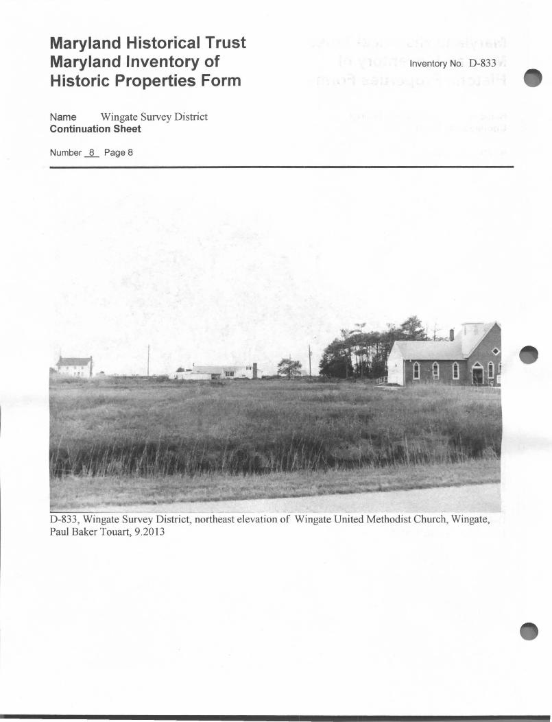
The south end of the community is located primarily along the Wingate-Bishops Head Road and Farm Creek Road. The Wingate United Methodist Church, located on the south side the Wingate-Bishops Head Road is a early twentieth century Gothic Revival frame structure defined by pointed arch colored glass windows and partially covered by a mid twentieth century brick veneer. A double-door entrance is flanked by three pointed arch windows, and the gable end is pierced by a diamond-shaped colored glass window. Rising atop the corner of the original church is a square bell tower pierced by pointed arch louvered vents. The top of the bell tower is accented by a simple railing. Attached to the southeast side of the main block is a mid twentieth century concrete block and brick veneered wing that reused pointed arch windows.
Similar to the other watermens' communities in southwester Dorchester County, the oldest surviving house types include the late nineteenth century, two-story, two- or three-bay single-pile, one-room or side hall/patlo plan dwellings supported on brick pier foundations and covered with plain weatherboards or asbestos shingles or

Maryland Historical Trust Maryland Inventory of Historic Properties Form
Name Wingate Survey District Continuation Sheet
Number _i_ Page 1
Inventory No. D-833
vinyl siding. The steeply pitched roofs have boxed cornices with extended eaves. Piercing the gable ends are interior brick stove chimneys. Attached to the back or gable ends of the main block are single-story or two-story rear wings. These houses are lighted by six-over-six, two-over-two or single-pane sash windows.
There are as well examples of asymmetrical T- or ell-shaped Victorian dwellings supported on pier foundations and covered with weatherboards. The early to mid twentieth century dwellings follow common bungalow and four-square house forms in frame construction. During the mid to late twentieth century, a scattering of Ranch style houses has been added to the landscape. Some of the property is occupied by resident owners, while other houses and acreages have been purchased by non-residents for second homes or hunting properties.

8. Significance Period
1600-1699 1700-1799
x _ 1800-1899 x 1900-1999
2000-
Specific dates
Areas of Significance
_ agriculture _ archeology x architecture
art ~ commerce
communications _ community planning
conservation
Construction dates
Evaluation for:
___ National Register
Inventory No. D-833
Check and justify below
economics education
_ engineering entertainmenU
recreation _ ethnic heritage _ exploration/
settlement
health/medicine _ performing arts _ industry _ philosophy
invention _ politics/government _ landscape architecture religion
law science literature _ social history
_ maritime history _ transportation _ military other:
Architect/Builder
____ ,Maryland Register -~x __ not evaluated
Prepare a one-paragraph summary statement of significance addressing applicable criteria, followed by a narrative discussion of the history of the resource and its context. (For compliance projects, complete evaluation on a DOE Form - see manual.)
SIGNIFICANCE SUMMARY
Wingate, Maryland is a small watermens' community located in southwestern Dorchester County, and a collection of approximately forty ( 40) contributing resources define this historic village that surfaced during the mid to late nineteenth century. The historic structures range in date from c. 1870 to c. 1950 and were built during the peaks in profits related to oyster packing and vegetable canning during the late nineteenth and early twentieth centuries. While there are distinctive examples of late nineteenth and twentieth century vernacular houses, the collection does not warrant listing on the National Register of Historic Places due to significant loss of integrity through alteration, abandonment, deterioration and demolition.
HISTORY AND SUPPORT
The village of Wingate in southwestern Dorchester County is a rural community that developed during the second half of the nineteenth and early twentieth centuries in a response to the growth in the seafood packing and vegetable canning industries that defined the entire region. When the coast lines of Dorchester County were surveyed by the U.S. engineers producing detailed maps of the Chesapeake Bay, the county road through the area featured small farms, patches of woodland, and marsh that bordered the inlets and creeks feeding into the Honga River. 1 At the north end of Insley Cove, near the present-day boat ramp, the engineers sited a wind mill, likely similar to the timber framed smock mills erected across southwestern Dorchester County during the eighteenth and early nineteenth centuries.
With the mechanization of agriculture during the second half of the nineteenth century, the much of the remaining woodlands were cleared and agricultural production reached its peak. By the time the 1877 Lake, Griffing and Stevenson atlas was printed, a village, although unnamed, was clearly growing with clusters of houses along the road to Bishops Head. 2 Near the site of the windmill was a store operated by I.M. Insley &
1 AD. Bache, principal engineer, U. S. Coast Survey-Mouth of Honga River and Hooper's Straits, 1848.
2 John L. Graham, ed . The 1877 Atlases and Other Early Maps of the Eastern Shore of Maryland, Salisbury, Wicomico
Bicentennial Committee, 1976, p. 80.

Maryland Historical Trust Maryland Inventory of Historic Properties Form
Name Wingate Survey District Continuation Sheet
Number_§_ Page 1
Inventory No. D-833
Brother. Across the road was a farm owned by William M. Wingate, who had acquired 35 acres of "Todd's Luck" in May 1875.3 Listed as an undertaker and a carpenter in the 1880 U.S. Census, the "Todd's Luck" farm passed to his wife Elizabeth and then to their son, Charles M. M. Wingate in 1904.4 Indicated on the map and running through the growing village was the proposed right-of-way of a branch line of the Dorchester & Delaware Railroad that was to extend from Cambridge to Bishops Head point.
The predominance of Wingate family residents in this immediate area surely inspired the naming of the village during the late nineteenth century in an effort to differentiate it from nearby Bishops Head, the site of another local store and the location of the district post office. In 1890, when a Methodist membership distinct from the St. Thomas congregation in Bishops Head decided to establish its own congregation, the Wingate Chapel was erected along the main road at the south end of the village. A replacement frame church was erected during the early twentieth century. 5
During the early twentieth century the village population continued to grow along with the county's general population, and the period witnessed the formation of several vegetable packing companies established between 1900 and the 1920s. Concurrent with the growth of the vegetable canning industry locally was the exploitation of oyster beds in nearby bays and river bottoms of tributaries of Chesapeake Bay. The community was prosperous enough to warrant the location of a branch of the Eastern Shore Trust Company, known as the South Dorchester Bank, in Wingate around 1914. (See D-846) The South Dorchester Bank lasted until the early 1940s.
The prosperity associated with the vegetable and seafood industries, however, started to wane during the second quarter of the twentieth century, especially after the stock market failure in 1929. The boom in the seafood industry was on a decline as well during the period. Since the mid twentieth century farming has largely been discontinued in the Strait election district with the former fields growing into woodlands. The housing stock erected during the late nineteenth and early twentieth centuries is reaching levels of deterioration that threaten their futures. Many houses are abandoned. Some efforts are being made to raise houses, old and new, on higher masonry foundations to combat future natural disasters and the threat of sea-level rise.
3 Dorchester County Land Record, FIB 10/150, 31 May 187 5, Dorchester County Courthouse, Cambridge. 4 Dorchester County Land Record, CL 29/613, 11 August 1904, Dorchester County Courthouse, Cambridge. 5 E. C. Hallman, The Garden of Methodism, Peninsula Annual Conference, 1948, p. 312.

Maryland Historical Trust Maryland Inventory of Historic Properties Form
Name Wingate Survey District Continuation Sheet
Number .JL Page 2
Duck
~
HearnJ Co!fe
Long Point
D-833, Wingate Survey District - Wingate, Md Quadrangle, 1982
\ Crab Point
O!f
Inventory No. D-833

Maryland Historical Trust Maryland Inventory of Historic Properties Form
Name Wingate Survey District Continuation Sheet
Number _JL Page 3
~ ·
. . . ... ' - ... -. ·· .... ____ ..
-_-;- - . ... --·-
Inventory No. D-833

Maryland Historical Trust Maryland Inventory of Historic Properties Form
Name Wingate Survey District Continuation Sheet
Number .JL Page 4
\
rl
-.. \J, -*'· ! ' .. ~··
·· ~y_, . I i .j
I
\ ----~- .. ·-··· -· --··· - ~·J. -r~ ·-- -:-·-i ..
D-833, Wingate Survey District U.S. Coas t Survey- Mouth of the Honga River and Hooper's Straights-1848
Inventory No. D-833

Maryland Historical Trust Maryland Inventory of Historic Properties Form
Name Wingate Survey District Continuation Sheet
Number__§__ Page 5
Inventory No. D-833
D-833, Wingate Survey District, southwest elevation of Wingate Manor (D-834), Wingate, Paul Baker Touart, 9.2013

Maryland Historical Trust Maryland Inventory of Historic Properties Form
Name Wingate Survey District Continuation Sheet
Number .JL Page 6
Inventory No. D-833
D-833, Wingate Survey District, Wingate Manor cemetery, Paul Baker Touart, 9.2013

Maryland Historical Trust Maryland Inventory of Historic Properties Form
Name Wingate Survey District Continuation Sheet
Number .JL Page 7
Inventory No. D-833
D-833 , Wingate Survey District, northwest elevation of former South Dorchester Bank (D-846), Paul Baker Touart, 9.2013
Maryland Historical Trust Maryland Inventory of Historic Properties Form
Name Wingate Survey District Continuation Sheet
Number -1!._ Page 8
Inventory No. D-833
D-833, Wingate Survey District, northeast elevation of Wingate United Methodist Church, Wingate, Paul Baker Touart, 9.2013

Maryland Historical Trust Maryland Inventory of Historic Properties Form
Name Wingate Survey District Continuation Sheet
Number .JL Page 9
Inventory No. D-833
D-833, Wingate Survey District, southwest elevation of houses along the Wingate-Bishops Head Road, Wingate, Paul Baker Touart, 9.2013.

Maryland Historical Trust Maryland Inventory of Historic Properties Form
Name Wingate Survey District Continuation Sheet
Number .JL Page 10
D-833 , Wingate Survey District, Wingate, Maryland, Paul Baker Touart, 9.2013
Inventory No. D-833

9. Major Bibliographical References t Inventory No. D-833
Dorchester County Land Records, various volumes, Dorchester County, Maryland.
10. Geographical Data
+/- 400 A Acreage of surveyed property Acreage of historical setting Quadrangle name Wingate.MD Quadrangle scale: ~l =:2~4~0~00~------
Verbal boundary description and justification
The metes and bounds of this property are coincidental with the current boundary of the lot.
11. Form Prepared by
name/title
organization
street & number
city or town
Paul B. Touart, Architectural Historian
Private Consultant date 9.4.2013
P. 0 . Box 5 telephone 410-651-1094
Westover state Maryland 21871
The Maryland Inventory of Historic Properties was officially created by an Act of the Maryland Legislature to be found in the Annotated Code of Maryland, Article 41 , Section 181 KA, 1974 supplement.
The survey and inventory are being prepared for information and record purposes only and do not constitute any infringement of individual property rights.
return to: Maryland Historical Trust DHCD/DHCP 100 Community Place Crownsville , MD 21032-2023 410-514-7600

Maryland Historical Trust Maryland Inventory of Historic Properties Form
Name Wingate Survey District Continuation Sheet
Number _JL Page 1
I ' Inventory No. D-833

Duck
Gr.eat
Hearns Cove
Light 0
Long Point
D-833, Wingate Survey District Wingate, Md Quadrangle, 1982
Crab Point
Cov~ I I
\
·/ ,,_1
( ' +
.i
-..i.---J-irn---=~~~:.·\~;ji;1~i!ri~t~,•tli;;:,.;;i;;:f;\-'"'~"":i?'i-----1 OfiO 000 FEET 'OS 5'
/
":\[ "06
HOG ISLA1'0 1.2 IW t "()7 /BLOOD
~CALE 1:24- O·


