wind conditions are an important consideration for … · wind conditions are an important...
TRANSCRIPT

Environment Canada – national marinE wEathEr guidE – Chapter 2 – wind 25
1. IntroductionWind conditions are an important consideration for anyone who travels by water. Vessels of all types and sizes – from canoes and sailboats to fishing boats and cruise ships – are affected by the wind to different degrees.
Strong, gusty winds can force boats off course or into hazards, such as rocks, shoals, or the shoreline. They can also cause high, choppy waves that can make boats difficult to handle or, in extreme cases, swamp or capsize them. Strong winds and rough water from winds accounted for over 40 percent of recreational boating deaths by drowning and hypothermia in Canada between 1991 and 2008.1
Weather maps can be used to help determine the prevailing wind direction on a large scale. On a local scale, however, differences in the stability of the atmosphere and the physical qualities of the earth’s surface have a major impact on the speed and direction of the wind.
A clear understanding of these effects can help a mariner better prepare for the day’s winds by taking into consideration both the prevailing wind direction and the local conditions. This chapter explains how different wind conditions form, the hazards associated with them, and tips for mariners on how to deal with them as safely as possible. For information on how to interpret wind information on a weather map, please see Chapter 1.
2. How Wind is FormedAir near the earth’s surface is heated or cooled by the land and water below it. Where the surface is warmer, it heats the overlying air, causing it to rise. Warm air rises because it is less dense – and therefore lighter – than cold air. The rising air creates a lack of air pressure in the area, called a “low”. Where the surface is cooler, it cools the overlying air, causing it to sink. This creates an excess of air pressure, called a “high”.
This differential heating of the earth’s surface and the resulting system of high and low pressures can form on a global scale as well as a local one.
Wind conditions are an important consideration for anyone who travels by water.
1 Transport Canada and the Canadian Red Cross Society. Boating Immersion and Trauma Deaths in Canada: 18 Years of Research (1991-2006), 2010.
Chapter 2: wind

26 Environment Canada – national marinE wEathEr guidE – Chapter 2 – wind
Wind is the term for moving air. It is created when air in a higher pressure area flows into an area of lower pressure to take the place of the air that is rising away. This restores balance to the system. An easy way to understand this is to imagine the atmosphere as a bucket of water: if a scoop of water is taken away (creating a low), the surrounding water (a high) rushes in to replace it.
The more difference there is in pressure between two areas, the more forcefully the air will flow between them – and the stronger the wind will blow.
If the earth did not turn, this pressure gradient force would cause air to flow directly from a high-pressure area to a low-pressure area. Since the earth does turn, another force – called the Coriolis force – causes the air to turn as well.
In the northern hemisphere, the wind around a high turns clockwise and the wind around a low turns counter-clockwise. The opposite is true in the southern hemisphere. When the effects of the pressure gradient force and the Coriolis force combine, the result is called the “geostrophic” wind.
Pressure Gradient Force
L
LH
H
1000 millibars
1004 millibars
980 mb
1016 mb
Pressure Gradient Force
Figure 2b – The geostrophic wind is the combined effect of the pressure gradient force and the Coriolis Force, which causes air flowing around areas of high and low pressure to turn in opposite directions.
Figure 2a – Under the effect of the pressure gradient force alone, wind would flow from an area of high pressure directly to an area of low pressure.
1000 millibars
1004 millibars
Pressure Gradient Force
L
LH
H
Coriolis Force
Geostrophic Wind
Geostrophic Wind

27Environment Canada – national marinE wEathEr guidE – Chapter 2 – wind
When the wind flowing around highs and lows comes in contact with the surface of the earth, friction causes it to slow down and shift slightly counter-clockwise. This allows the wind to blow slightly from areas of high pressure to areas of low pressure. It is important to remember that different surfaces have different levels of friction. Wind over water experiences less drag than it does over land, so it maintains more speed and shifts only 15 to 20 degrees. Wind over land, on the other hand, can change direction by as much as 30 to 40 degrees.
3. Effects of Atmospheric Stability on WindAs explained in Chapter 1, atmospheric stability is a measure of whether the atmospheric conditions in an area make it harder or easier for air to rise and fall. A stable atmosphere makes this upward and downward motion more difficult, while an unstable atmosphere encourages it. Atmospheric stability can be the same over a large area or isolated to a small, protected area. This is an important factor to take into account when determining wind speeds.
3.1 Stable AtmosphereWhen a parcel of air cools faster than the surrounding atmosphere, it is not able to rise because it is heavier than the air around it. The atmosphere is “stable” because it is experiencing little or no vertical movement.
1000 millibars
1004 millibars
Pressure Gradient Force
L
LH
H
Surface Wind
Figure 2c – The speed and direction of the surface wind depends on how the geostrophic wind is affected by friction from the earth’s surface.
waterwater
Stable Stable
light smooth wind
heavy andgusty wind
UnstableUnstable
waterwater
Atmospheric Stability and Wind
Figure 2d-1 – Whether the atmosphere makes it harder (stable) or easier (unstable) for air to rise and fall also has a significant effect on wind.

28 Environment Canada – national marinE wEathEr guidE – Chapter 2 – wind
How does a stable atmosphere affect wind?Stable conditions mean winds are generally lighter and less gusty. A stable atmosphere over water can create cool, calm conditions throughout the day, even if it is windy over the land nearby.
Mariners’ TipsThe presence of small, puffy clouds on a fair day is a good sign that the atmosphere is stable. The clouds cannot rise because they are blocked by a layer of warm air.
For the same reason, if smoke rising from a chimney or industrial smoke stack on a calm day has a sharp cut-off point where it spreads out horizontally instead of rising further, the atmosphere is stable.
If the atmosphere is stable and there are no other factors at play, winds should be about the same as or lower than they would appear on a weather map (see Chapter 1, section on How to Read a Weather Map).
3.2 Unstable AtmosphereWhen a parcel of air cools more slowly than the surrounding atmosphere, it will continue to rise because it is lighter than the air around it. The atmosphere is “unstable” because it is experiencing vertical movement.
How does an unstable atmosphere affect wind? When the atmosphere is unstable, warmer air at the surface rises and draws down some of the cold, windy air from higher in the atmosphere. This causes gusty
Downdraft
First gust
Faster winds
Cumulonimbus cloud Anvil
Storm movement
Thunderstorm Downdraft
Slower windsA moving downburst
Faster winds
Shelf cloud
A moving downburstA moving downburst
Gust front
Figure 2e-1 – Thunderstorm downdrafts create stronger winds well ahead of a storm front and slower ones in its wake.
X
Y
L
Air temperature = 0˚CWater temperature = 10˚C Unstable air
Air temperature = 20˚CWater temperature = 10˚CStable air
Effects of Atmospheric Stability in a Low Pressure System
Figure 2d-2 – Although the whole area on this map is under a low-pressure system, the air over X is much cooler than the water below it and the air over Y is much warmer. This creates unstable atmospheric conditions and stronger winds (illustrated by the line of pointed wind barbs) over X and a stable atmosphere and more predictable winds (illustrated by the line of rounded wind barbs) over Y.

29Environment Canada – national marinE wEathEr guidE – Chapter 2 – wind
winds that can vary suddenly in speed and direction. If the air rises rapidly, large towering clouds, showers, or even thunderstorms may develop.
When rain or hail from a thunderstorm cloud falls through dry air and evaporates, it cools the surrounding air. The cool air drops quickly to the surface of the earth and spreads out, an effect known as a “thunderstorm downdraft” or “gust front”. This can cause sudden shifts in wind speed and direction, a drop in temperature, and heavy precipitation—sometimes several kilometres ahead of an advancing storm.
Mariners’ TipsA sky heaped with towering dark clouds is a sign that the air is rising rapidly and the atmosphere is unstable. It can also mean that a powerful thunderstorm is approaching.
A gust front is often marked by the appearance of a low, horizontal, wedge-shaped cloud, called a “shelf cloud”, on the front of an approaching thundercloud.
Figure 2e-2 – A shelf cloud is an indication that a gust front is approaching.
4. Nearshore Effects on WindNear the coastline and on lakes, winds are greatly affected by local factors. These include differences in the way the sun heats the land and water and in the physical features of the land itself. When winds interact with these factors, they can change drastically from what mariners might expect based on weather maps alone.
4.1 Solar HeatingNot all parts of the earth’s surface heat up and cool down at the same rate. Heat from the sun is absorbed and released faster by some surfaces than others. For example, land warms more quickly than water, but water holds its heat longer.

30 Environment Canada – national marinE wEathEr guidE – Chapter 2 – wind
Solar heating also depends on the location of the site, its exposure to the sun, the season, and the time of day. In mountains and valleys, for example, some areas are cooler because they are in the shade for much of the day.
This differential heating creates a small-scale system of highs and lows that alters the direction of the prevailing wind.
4.1.1 Sea BreezeA sea breeze is a cool wind that blows onshore: that is, from the sea or any other large body of water toward the land. It usually starts in the morning and can intensify over the course of the day. Sea breezes are typically felt up to eight kilometres offshore but can reach as far as 30 kilometres. They are stronger off east- or south-facing shorelines, which receive more direct sunlight.
How is a sea breeze formed? Sea breezes form when the prevailing winds are relatively light (usually around 15 knots) and the cloud cover is less than 50 percent. They typically start in the morning as the heat from the sun causes the land to warm up at a faster rate than the water. This creates a “low” over the land and a “high” over the water, which causes cool air from the sea to flow inland to replace the warm air that is rising and flowing out to sea. This circulation pattern strengthens over the course of the day as the temperature difference between the land and water increases. As the day progresses, wind speed increases and wind direction shifts clockwise 50 to 60 degrees.
Winds are usually light beyond the outer edge of the sea breeze, where the warm air flowing out to sea cools and falls to the surface of the water. This area of calm – called the sea breeze anti-front – moves further offshore as the circulation strengthens. Sea breezes typically die out or weaken substantially an hour before sunset.
Circulation cell can extend 10 - 30 kilometres offshore
CALMSea breeze front CALM
Sea breeze anti-front
Sea Breeze Circulation Cell
Figure 2f-1 – A sea breeze circulation cell forms when warm air over the land rises and flows out over the water. As the air cools, it sinks and flows back onshore to take the place of the rising air.
AfternoonAfternoon
MorningMorning
Sea Breeze
Figure 2f-2 – As the day progresses, the sea breeze shifts direction clockwise.

31Environment Canada – national marinE wEathEr guidE – Chapter 2 – wind
How are sea breezes affected by irregular coastlines?Sea breezes that blow near an irregular coastline with a number of bays and islands behave differently than they do elsewhere and can pose a challenge to mariners.
In the morning, air flows from the water toward the land wherever the two touch. This can create strange breezes around islands and cause the winds in a bay to blow in several different directions.
As the day progresses, sea breezes start to blow as if the coastline is straight: that is, more directly inland. This creates calm conditions in areas hidden behind an island or protected by a spit of land. In the late afternoon, when the wind has sped up and shifted direction, areas that were calm will experience the same conditions as their neighbours.
What hazards are associated with sea breezes?Sea breezes can create winds of 10 to 15 knots near shore. Wind speeds can be even higher if the prevailing winds are blowing the same direction or the physical features of the shoreline have a funnelling effect (see Section 4.2.2). If a sea breeze blows a fog bank toward shore, navigation can be hazardous.
Late morning
A little later
calm
calm
Late afternoon
Sea Breezes and Irregular Coastlines
Figure 2f-3 – Sea breezes blow in different directions along an irregular coastline depending on the time of day.
Figure 2f-4 – Cloud formation over the Great Lakes during a well-established sea breeze.

32 Environment Canada – national marinE wEathEr guidE – Chapter 2 – wind
Mariners’ TipsSea breezes can often be detected as a line of clouds over the coastline or a line of low clouds, just offshore, that dissolves quickly. Other signs include sudden calm winds or irregular bursts of wind, a sudden drop in temperature, and a sky that clears faster than usual.
4.1.2 Land BreezeA land breeze is the reverse of a sea breeze, in that it blows offshore—from the land towards the sea or any other large body of water. Land breezes are generally weaker and less frequent than sea breezes but can still cause gusty wind conditions for boaters.
How is a land breeze formed?Land breezes form at night or during the day in colder seasons when the temperature of the air at the surface of the land drops lower than the temperature of the air at the surface of the water. They can also form when the shore has been in shadow most of the day and is colder than the water.
These temperature differences occur because land not only warms up faster than water but also cools down faster. Water, on the other hand, holds its heat longer.
The cooler air over the land creates a high-pressure area, while the warmer air over the water creates an area of low pressure. If the prevailing winds are not strong enough to oppose it, a circulation pattern will be set in motion in which the cool air from the land blows offshore to take the place of the warmer air rising over the water. Land breezes die out once the sun returns and the land warms up again.
How do similar conditions occur at ice edges?Sea ice and open water can create circulation patterns similar to a land breeze. In this case, the colder air over the sea ice rushes out toward the open water to take the place of the warmer air rising from the ocean. This creates strong, gusty winds over the open water.
Circulation cell can extend 10 - 30 kilometres offshore
Land breeze anti-frontCALM CALM
Land breeze front
Land Breeze Circulation Cell
Figure 2g-1 – A land breeze circulation cell is formed when warm air over the water rises and flows over the land. As the air cools, it sinks and flows out toward the sea to replace the rising air.

33Environment Canada – national marinE wEathEr guidE – Chapter 2 – wind
What hazards are associated with land breezes?Although land breezes are usually weaker than sea breezes, they are still very gusty – particularly when they are in full force. They can be even stronger if the prevailing winds are blowing in the same direction or the physical features of the shoreline have a funnelling effect (see Section 4.2.2). If there is enough moisture in the air and the atmosphere is unstable, land breezes can also cause showers or thunderstorms over the water.
4.2 Topography
Topography refers to the physical features of the earth’s surface. Deep valleys, tall peaks, and narrow channels are just some examples of the different types of topography that can alter the speed and direction of the wind. Added effects are caused by friction from trees, snow and ice, and other land cover, as well as from water.
4.2.1 Wind Blowing Between the Shore and the Water
Wind Blowing OffshoreWater creates less friction than land, so wind blowing offshore picks up speed and veers clockwise slightly. Wind speed stops increasing within about 16 kilometres of the shore but can become quite high if the atmosphere is unstable.
What hazards does this pose?Since wind gathers speed as it blows offshore, boaters should consider how much stronger it might be the further out they are.
At the same time, boaters sticking close to shore, where the offshore winds are usually lighter, should think about how the topography of the shoreline might affect wind speed and direction.
SeaWind
Land Wind
Wind Blowing Offshore
Ice Edge Fog
30 metres distance
Figure 2g-2 – In calm prevailing wind conditions, wind similar to a sea breeze can form near ice edges. Warm air over the open water rises and flows over the cool ice, where it eventually sinks and flows back toward the water to replace the rising air.
Figure 2h – Wind blowing offshore speeds up and shifts direction clockwise.

34 Environment Canada – national marinE wEathEr guidE – Chapter 2 – wind
Wind Blowing OnshoreWind blowing onshore slows down and veers or “backs” counter-clockwise slightly, due to the added frictional drag caused by the land.
What hazards does this pose? Because wind loses speed over land, the wind speed reported by a land-based station –even one very close to shore—could be much lower than the wind speed occurring further offshore.
Lee EffectLee effects are winds experienced on the downwind (lee) side of an obstacle. Near the shoreline, they often occur when winds blowing either toward the land or toward the water interact with the face of a cliff or other steep embankment.
What causes lee effects?When wind blowing onshore is blocked by a cliff face or other steep obstacle, some of it is deflected downward and reverses direction while the rest is forced up and over the cliff. This makes the wind turbulent and unpredictable near the shoreline.
When wind blowing offshore passes over a cliff edge, it flows down toward the surface of the water. Where it touches the water, it splits in two directions, creating an area of calm. Part of the wind flows back toward shore, where it interacts with the cliff face and creates turbulent conditions near shore. The rest flows out to sea, creating alternating zones of gusty and light winds as it touches down and bounces away from the surface in a wavelike motion.
Sea Wind
Land Wind
Wind Blowing Onshore
Figure 2i – Wind blowing onshore slows down and shifts direction counter-clockwise.
100% Geostrophic wind speed100% Geostrophic wind speed
ON WATER
80 - 70% Geostrophic wind speed
ON WATER
80 - 70% Geostrophic wind speed
ON LAND
60 - 50% Geostro
phic
wind speed
ON LAND
60 - 50% Geostro
phic
wind speed
15o to 20o
15o to 20o
Frictional Effects on Geostrophic Wind
Figure 2j – The speed and direction of the geostrophic wind is influenced by whether it blows over water or land. Over water, its speed decreases by 20-30 percent and it shifts direction clockwise by 15 to 20 degrees. Over land, its speed decreases by 40-50 percent and it shifts direction counter-clockwise by 30 to 40 degrees.

35Environment Canada – national marinE wEathEr guidE – Chapter 2 – wind
What hazards do lee effects pose?Wind blowing onshore becomes turbulent and gusty when it collides with a cliff near the shoreline. This can make activities near shore difficult and dangerous.
Wind blowing offshore also becomes turbulent and gusty as it passes over the edge of a cliff. With small cliffs, this may result in an area of calm near the shore. With larger ones, strong gusty winds can persist even near the shoreline.
Offshore wind also creates alternating zones of strong and light winds further out to sea – within a distance of about seven to ten times the height of the cliff. While the strong winds usually stay in the same place, the light ones sometimes change speed or reverse direction – in particular, when they are downwind of higher cliffs.
Mariners’ TipsOffshore wind blowing over the edge of a cliff causes a variety of calm and turbulent conditions between the shoreline and the open water further out to sea. Boaters should be aware that conditions could vary drastically as they move through this zone.
4.2.2 Wind Blowing Along the Shoreline
Coastal ConvergenceCoastal convergence causes a band of stronger wind to occur within a couple of kilometres of the shoreline. It happens when the shoreline is to the right of the direction the prevailing winds are blowing.
What causes coastal convergence?Coastal convergence is caused by differences in the frictional properties of water and land. When the shoreline is to the right of the prevailing wind direction, this difference causes the wind over the land to shift drastically toward the water. Where it collides with the wind over the water, the two pile up. Coastal convergence can be enhanced by an inversion.
Confused steep sea
Variable winds
Wind strength over the sea
Confused sea
Variable lee winds
7 to 10 times the height of the cliff
Lee Effects
Figure 2k – When wind is blowing offshore over a cliff, a pattern of alternating strong and calm winds can be put in motion over the water. When wind is blowing from the water directly toward a steep cliff, strong gusty winds can occur near the shoreline.

36 Environment Canada – national marinE wEathEr guidE – Chapter 2 – wind
What are the hazards of coastal convergence?Coastal convergence can cause winds around 25 percent stronger than those blowing over the nearby land or further out to sea. This could cause problems for some smaller boats.
Mariners’ TipsIn a situation where coastal convergence is well established, there are more clouds along the coastline. This happens because the piling up of the air forces some upward, where the moisture in the air is able to form clouds. These areas of enhanced cloud can produce precipitation and, under certain circumstances, cause heavy downpours and reduced visibility.
Coastal DivergenceCoastal divergence causes a band of weaker wind to form within a couple of kilometres of the shoreline. It happens when the shoreline is to the left of the direction the prevailing winds are blowing.
What causes coastal divergence?Coastal divergence is caused by differences in the frictional properties of water and land. When the shoreline is to the left of the prevailing wind direction, this difference causes the wind blowing over the two surfaces to separate at the coast.
What are the hazards of coastal divergence?When coastal divergence is occurring, winds can be up to 25 percent lighter within a couple of kilometres of the shore. This can give boaters a false sense of the prevailing wind direction and wind speed further out to sea.
Coastal Convergence
Figure 2l – When the shoreline is to the right of the prevailing wind direction, the wind over the land and the wind over the water will collide, creating a band of stronger winds just offshore.
Coastal Divergence
Figure 2m – When the shoreline is to the left of the prevailing wind direction, the wind over the land and the wind over the water separate, creating a band of weaker winds just offshore.

37Environment Canada – national marinE wEathEr guidE – Chapter 2 – wind
ChannellingChannelling occurs when the prevailing wind is forced to change direction because it comes into contact with a physical feature of the land—be it coastline, a mountain range, or the walls of a river valley. Channelling does not affect wind speed.
What causes channelling?When the wind encounters an obstacle, it shifts direction so it can continue flowing without being blocked or impeded. As it blows along the coastline, for example, the wind is constantly being redirected to follow the outline of the land.
What are the hazards of channelling?Channelling can make the wind direction on the water very different from the prevailing wind or even the forecasted wind direction.
FunnellingFunnelling occurs when the wind flows through a narrow opening between two adjacent pieces of land, such as a narrow channel between two islands or a narrow river valley. This causes the speed of the wind to increase but does not affect its direction.
What causes funnelling?In the same way water flowing out of a hose increases in pressure when part of the nozzle is blocked, wind picks up speed when it passes through a narrow opening in the land. Wind flowing along a shoreline, for example, often speeds up as it blows between two islands, between an island and the coastline, or into a narrow inlet or bay.
What are the hazards of funnelling?Even when the prevailing wind is light, boaters should be prepared for higher wind speeds in areas prone to funnelling. In particular, caution should be exercised near narrow openings, where winds can be very gusty and their speeds up to twice as high.
Channelling
Figure 2n – When wind encounters a physical obstacle, its direction is altered but not its speed.
Funnelling
Figure 2o – When wind flows through a narrow opening in the land, its speed is altered but not its direction.
38 Environment Canada – national marinE wEathEr guidE – Chapter 2 – wind
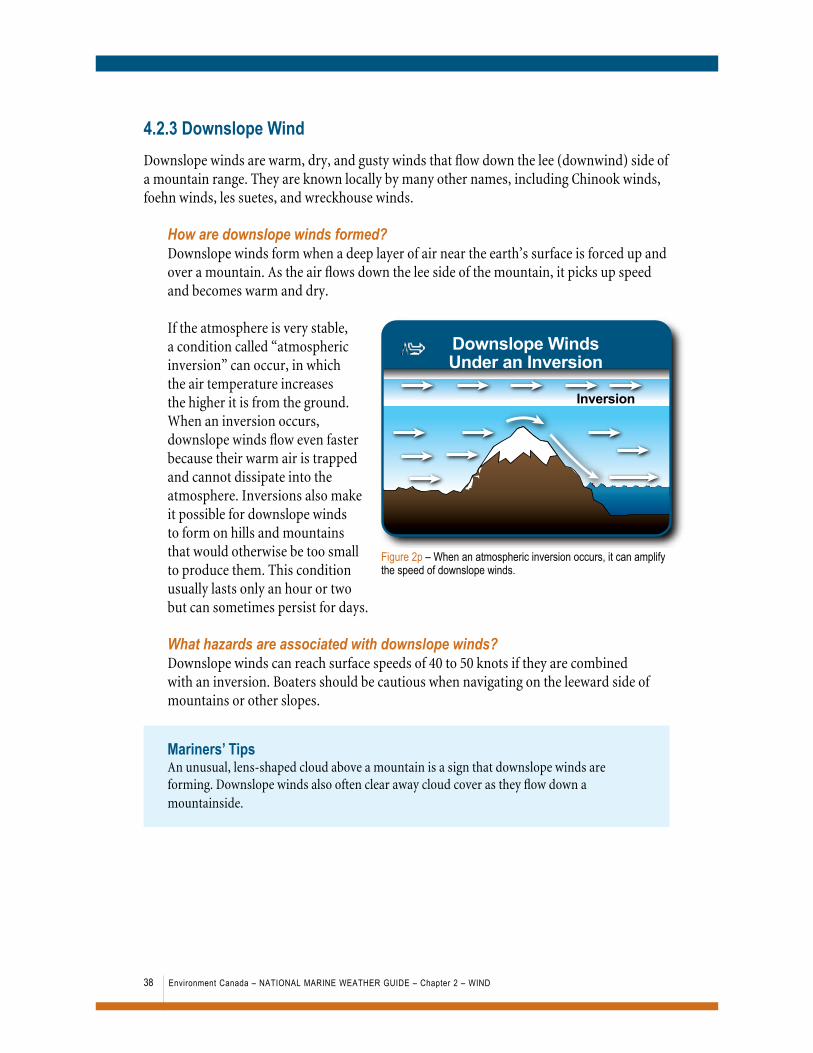
4.2.3 Downslope WindDownslope winds are warm, dry, and gusty winds that flow down the lee (downwind) side of a mountain range. They are known locally by many other names, including Chinook winds, foehn winds, les suetes, and wreckhouse winds.
How are downslope winds formed?Downslope winds form when a deep layer of air near the earth’s surface is forced up and over a mountain. As the air flows down the lee side of the mountain, it picks up speed and becomes warm and dry.
If the atmosphere is very stable, a condition called “atmospheric inversion” can occur, in which the air temperature increases the higher it is from the ground. When an inversion occurs, downslope winds flow even faster because their warm air is trapped and cannot dissipate into the atmosphere. Inversions also make it possible for downslope winds to form on hills and mountains that would otherwise be too small to produce them. This condition usually lasts only an hour or two but can sometimes persist for days.
What hazards are associated with downslope winds?Downslope winds can reach surface speeds of 40 to 50 knots if they are combined with an inversion. Boaters should be cautious when navigating on the leeward side of mountains or other slopes.
Mariners’ TipsAn unusual, lens-shaped cloud above a mountain is a sign that downslope winds are forming. Downslope winds also often clear away cloud cover as they flow down a mountainside.
Downslope WindsUnder an Inversion
Inversion
Figure 2p – When an atmospheric inversion occurs, it can amplify the speed of downslope winds.

39Environment Canada – national marinE wEathEr guidE – Chapter 2 – wind
Figure 2p-2 – The appearance of “lenticular” or lens-shaped clouds over a mountain is a sign of downslope wind conditions. Photo: Brewster Travel Canada
4.3 Combined EffectsWind on oceans, lakes, and rivers is usually a combination of many different factors happening at once. They include conditions in the atmosphere and conditions at the earth’s surface. While topographic features, temperature, and friction each have their own unique effects, they never act alone. The potential combined effects of these factors are endless, but some common ones are explained further in this section.
4.3.1 Combined Effects of Topography
Gap WindWinds that have been affected by both channelling and funnelling are called gap winds. This means that they have not only been forced to change direction by a physical feature of the land but also to increase in speed by being squeezed through a narrow gap.
Gap wind is often used to describe wind that occurs where the coastline narrows and changes direction at the same time. It is also used more generally to describe any wind affected by a narrow gap. Outflow winds and fiord winds are types of gap winds, in that they are created by the same processes but under different conditions.
Gap Wind
Figure 2q – Winds affected by both channelling and funnelling change direction and speed.

40 Environment Canada – national marinE wEathEr guidE – Chapter 2 – wind
Outflow WindOutflow winds are strong winds created when air is forced to flow between two mountains or a break in a mountain range. The uneven shape of the mountains also causes the wind to change directions as it passes through. In some parts of the country, these winds are better known as Arctic outflow winds.
Fiord WindFiord winds are winds funneled through the steep walls of a fiord. Depending on the direction of the prevailing wind, winds inside the fiord and at its downwind opening can be either stronger or much weaker.
If the prevailing wind is blowing the same direction as the fiord, wind speed will increase slightly due to the effect of funnelling. If it is blowing at a slight angle to the fiord, the combination of funnelling and channelling could cause the wind speed to almost double. If the prevailing wind direction is perpendicular to the orientation of the fiord, the wind speed within it will be much weaker.
What are the hazards of gap winds?Gap winds can create strong, gusty wind conditions between narrow coastlines, mountains, and fiords. Mariners should be very careful when navigating in gaps or crossing in front of them, as winds in these areas can be much stronger and the direction they are blowing can be unexpected. Near the exit to the gap, the wind speed can be 30 knots or more than that of the prevailing wind.
Mariners’ TipsWhen winds are blowing at a right angle to a narrow gap in the terrain, mariners may find shelter within the gap, where the winds will be significantly lighter.
Fiord Wind
FiordWind
Figure 2r – Wind blowing at a slight angle to a fiord can increase the speed of the prevailing wind by as much as double.

41Environment Canada – national marinE wEathEr guidE – Chapter 2 – wind
Barrier WindBarrier winds are strong and sometimes gusty and turbulent winds that occur along a steep shoreline when the winds are blowing from the water. They are a kind of “lee effect” caused by a combination of coastal convergence and funnelling.
How are barrier winds formed?When winds blowing from the water toward the coastline strike a cliff or steep embankment, they change direction. If they strike at an angle, they shift to follow the shoreline and their speed can as much as double. If, however, they blow directly at the shore, some will be deflected back and some will shift and run along the shoreline. This causes gusty and turbulent conditions near the coast.
What are the hazards of barrier winds?Barrier winds can create strong, turbulent wind conditions along the coast. This can make boating in the area near the shoreline unsafe.
Corner EffectsCorner effects are the effects of funnelling combined with either coastal convergence or coastal divergence. In certain conditions, they can cause strong winds and turbulent, gusty conditions around steep islands and peninsulas.
How are corner effects formed?When wind is blocked by a steep island or peninsula, it is forced to travel over and around it. In the case of an island, wind is forced around both sides. In the case of a peninsula, the wind shifts direction to flow around the corner.
When the shore of an island is to the right of the prevailing wind direction, coastal convergence and funnelling will combine to increase
High Land
Cliff
Confused seas
Barrier Wind
Figure 2s – Onshore winds blowing toward a steep coastline can create hazardous wind conditions near shore.
Steep Island
Lee effects
Cornering Coastaldivergence
Corner Effects Around a Steep Island
Figure 2t – When wind flows around a steep island, if the shoreline is to the right of the prevailing wind direction, it will experience stronger winds than the opposite shore. Gusty and turbulent conditions will occur on the downwind side of the island.

42 Environment Canada – national marinE wEathEr guidE – Chapter 2 – wind
wind speed. When the shore is to the left, funnelling will still occur, but it will be weakened by the effect of coastal divergence. Some wind also flows up and over the island, creating gusty and turbulent winds on its downwind or lee side.
When the shore of a peninsula is to the left of the prevailing wind direction, coastal divergence and funnelling combine to create weaker winds near the shore. When the shore is to the right, coastal convergence and funnelling create stronger winds.
What are the hazards of corner effects?Mariners navigating around a steep island with the prevailing wind at their back will have to deal with much stronger winds on its left shore and more gusty and turbulent winds directly in front of it. In the case of a peninsula, boaters will encounter stronger winds when the shoreline is to the right of the prevailing wind direction.
Mariners’ TipsWhen approaching a steep island with the wind at their back, mariners should navigate around the right-hand side of the island, as the winds will be lighter than on the left. Boaters should be mindful of stronger wind conditions when navigating around a peninsula that lies to the right of the prevailing wind direction.
4.3.2 Combined Effects of Heating and TopographyDifferences in the way the land and water heat up and cool down influence the speed and direction of the wind, as shown in Section 4.1 of this chapter. “Differential heating” also occurs because of the physical features of the land. Where steep, sloping terrain is involved, heating and topography often combine to influence wind conditions.
Katabatic WindKatabatic wind is a strong, gusty wind that blows down the sides of a mountain, cliff, fiord, valley, or other steep slope from about midnight until early morning. It is known locally by other names, such as mountain wind, drainage wind, glacier wind, and blow-me-down.
Marine Wind
Back to the wind
Land Wind
Corner Effects at a Peninsula
Figure 2u – When the shore of a peninsula is to the right of the prevailing wind direction, stronger wind conditions will occur.

43Environment Canada – national marinE wEathEr guidE – Chapter 2 – wind
How is a katabatic wind formed?On a clear evening, heat from the surface of the earth radiates out into space, causing air temperatures near the surface to cool down. In areas sheltered by steep terrain, the air near the base of the slope stays warm longer than the air above it. This causes the cooler, heavier air near the top of the slope to flow downward—creating a strong wind. The speed of katabatic wind increases until just after dawn, when it starts to die out. Where slopes are topped with icy glaciers, katabatic wind is a more or less permanent condition.
What hazards are associated with katabatic winds?Katabatic winds can create unexpectedly windy conditions overnight. If they combine with a land breeze, they can reach even higher speeds. Depending on their strength, katabatic winds can be felt as far as three kilometres off shore.
Mariners’ TipsMariners should be careful when anchoring for the night in a harbour with high terrain nearby. A cove next to a steep coastline that seemed calm and sheltered the evening before may suddenly experience strong, gusty winds the next morning.
Anabatic WindAn anabatic wind is a mild wind that blows up the sides of a mountain, cliff, or other steep slope during the day. It is also known as a valley wind.
How is an anabatic wind formed?During the day, when the sun shines on a mountain, valley, cliff, or other steep terrain, it warms the sides of their slopes faster than it does the sheltered area at their base. This causes the warmer air on the slopes to rise and blow gently upward. Valleys with gentle slopes and slopes that face south have the strongest anabatic winds.
Katabatic Wind
Figure 2v – Cool air flowing down the sides of a steep slope creates gusty, unpredictable offshore winds over the water.
Anabatic Wind
Figure 2w – Warm air flowing up the sides of a slope creates weak onshore winds over the water.

44 Environment Canada – national marinE wEathEr guidE – Chapter 2 – wind
What hazards are associated with anabatic winds?Although anabatic winds are usually light, they can speed up and cause gusty conditions in harbours if they mix with a sea breeze.katabatic winds can be felt as far as three kilometres off shore.
Mariners’ TipsPuffy clouds above the sides of the valley are a sign of anabatic wind.
Cross Valley FlowA cross valley flow is a wind that circulates up one side of a valley and down the other. It happens during the day when downslope and anabatic winds occur at the same time in an enclosed, steep-walled lake valley or in a coastal inlet surrounded by steep topography.
How is cross valley flow formed?A cross valley flow forms when the slope on one side of a valley is facing direct sunlight while the slope on the other side is in shadow for an extended period of time. This causes an anabatic wind to form on the warm slope and allows a weak downslope wind to persist or form on the slope that is in shadow. This effect is enhanced or reduced by the prevailing wind direction and speed.
This sets in motion a unique circulation pattern. The warmer air from the anabatic wind flows upward and crosses over the valley to the top of the shadowed slope. There, the air cools and starts flowing downward—forming or strengthening a down slope wind. At the base of the slope, the cool air rushes across the water to the opposite side to take the place of the warm air rising with the anabatic wind.
Over the course of the day, as the sun moves across the sky and the sun and shade shift from one slope to the other, a cross valley flow can reverse direction.
What hazards are associated with a cross valley flow?Cross valley flows create unexpectedly different wind directions on either side of a basin of water. Boaters may also be surprised by the presence of anabatic winds that are much stronger than usual and downslope winds happening during the day.
AM PM
Cross Valley Flow
Figure 2x – When wind flows up the sunny side of a valley and down the opposite, shady side, it sets in motion a circulation pattern that can be enhanced or diminished by the prevailing wind.