wildfires, fuel treatment and risk mitigation in australian eucalypt forests: insights from...
TRANSCRIPT
at SciVerse ScienceDirect
Journal of Environmental Management 105 (2012) 66e75
Contents lists available
Journal of Environmental Management
journal homepage: www.elsevier .com/locate/ jenvman
Wildfires, fuel treatment and risk mitigation in Australian eucalypt forests:Insights from landscape-scale simulation
R.A. Bradstock a,*, G.J. Cary b, I. Davies b, D.B. Lindenmayer b, O.F. Price a, R.J. Williams c
aCentre for Environmental Risk Management of Bushfires, University of Wollongong, NSW 2522, Australiab The Fenner School of Environment and Society, The Australian National University, ACT 0200, AustraliacCSIRO Ecosystem Sciences, Winnellie, NT 0820, Australia
a r t i c l e i n f o
Article history:Received 30 September 2011Received in revised form13 March 2012Accepted 26 March 2012Available online 22 April 2012
Keywords:Prescribed fireClimate changeCost-effectiveness
* Corresponding author. Tel.: þ61 2 42215531; fax:E-mail address: [email protected] (R.A. Bradstock
0301-4797/$ e see front matter � 2012 Elsevier Ltd.doi:10.1016/j.jenvman.2012.03.050
a b s t r a c t
Wildfires pose significant risks to people and human infrastructure worldwide. The treatment of fuel inlandscapes may alter these risks but the magnitude of this effect on risk is poorly understood. Evidencefrom Australian Eucalyptus forests suggests that mitigation of risk using prescribed burning as a fueltreatment is partial because weather and fuel dynamics are conducive to regular high intensity fires. Wefurther examine the response of risk to treatment in eucalypt forests using landscape simulationmodelling. We model how five key measures of wildfire activity that govern risk to people and propertymay respond to variations in rate and spatial pattern of prescribed fire. We then model effects of pre-dicted climate change (2050 scenarios) to determine how the response of risk to treatment is likely to bealtered in the future. The results indicate that a halving of risk to people and property in these forests islikely to require treatment rates of 7e10% of the area of the landscape per annum. Projections of 2050weather conditions under climate change further substantially diminished the effect of rate oftreatment. A large increase in rates of treatment (i.e. circa. 50% over current levels) would be requiredto counteract these effects of climate change. Such levels of prescribed burning are unlikely to befinancially feasible across eucalypt dominated vegetation in south eastern Australia. Despite policyimperatives to expand fuel treatment, a reduction rather than an elimination of risk will result. Multi-faceted strategies will therefore be required for the management of risk.
� 2012 Elsevier Ltd. All rights reserved.
1. Introduction
Human and economic losses from natural disasters, includingwildfires, are increasing (Stephens et al., 2009a; Vos et al., 2010).Recent elevated, global fire activity associated with climate change(Bowman et al., 2009; Westerling et al., 2006) and human pop-ulation growth in and around major cities (Lowell et al., 2009;Stephens et al., 2009a; Syphard et al., 2009) is contributing to anincrease in the risk of loss of life and property and associated costs(Mell et al., 2010; Stephens and Ruth, 2005; Stockmann et al., 2010).Robust management solutions to the global fire problem aretherefore required.
Can the chance that people and their property will be harmed byfire be minimized or eliminated? Such risk is the outcome ofa complex chain of influences, ranging from the type and structureof vegetation, the proximity of buildings to fire-prone vegetation,
þ61 2 4221539.).
All rights reserved.
the predisposition of property to burning and management inter-ventions (Bradstock and Gill, 2001; Gibbons et al., 2012; Keeleyet al., 2009a; Stockmann et al., 2010). Risk could be eliminated bypreventing fires from reaching people and property and/orreducing the intensity of fires burning near human infrastructure tonegligible levels. Thus, the problem has the potential to be solvedsolely by management interventions in fire-prone landscapes.
There is considerable debate in many nations about how fire-prone landscapes should be managed to reduce the risk of majorconflagrations (Keeley et al., 2009a,b; Reinhardt et al., 2008;Stephens et al., 2009a). A widely proposed solution is to undertakeextensive treatment of fuel to decrease overall fuel mass per unitarea (loading) and alter vegetation structure (e.g. vertical conti-nuity) to diminish the rate of spread and size of wildfires (Finney,2005; Finney et al., 2007; Stephens et al., 2009b).
The likelihood that fuel treatment can significantly alter wildfireintensity and size has been challenged on the basis of contrastingevidence about the relative influences on wildfire behaviour of fuelcompared to weather and terrain (Keeley and Zedler, 2009; Keeleyet al., 2009a,b; Reinhardt et al., 2008; vanWilgen et al., 2010). Given
R.A. Bradstock et al. / Journal of Environmental Management 105 (2012) 66e75 67
climate change, urban expansion and increasing ignitions it isimperative to quantify the degree to which fuel treatments willmitigate risk in contemporary and future environments.
Fires that result in major losses of life and infrastructure arecommon in southern Australia due to the location of major citiesclose to native vegetation characterized by rapid fuel accumulationand high fuel loads, and regular episodes of severe fire weather(Blanchi et al., 2010; Bradstock and Gill, 2001; Gibbons et al., 2012).Such disasters and their environmental correlates are comparableto those in other parts of the world (e.g. southern California andEurope) where urban development is juxtaposed with highlyflammable vegetation (Keeley et al., 2011). The forested regions ofsouthern Australia provide a globally significant case study forunderstanding the nature of risk to people and infrastructure incomparable environments.
It is commonly claimed thatmajor fires in the forested regions ofAustralia result from inadequate fuel treatment (Parliament ofVictoria, 2008; Teague et al., 2010), and that increased levels offuel reduction would have minimized or eliminated risk. Inresponse, recent Australian inquiries have recommended majorincreases in the rate of treatment using prescribed fire (Parliamentof Victoria, 2008; Teague et al., 2010) but these recommendationsare not clearly predicated on a quantified level of risk reduction orreturn on investment.
Empirical studies in temperate eucalypt forests using long-term(i.e. 30e50 years), large scale (>106 ha) fire records indicate thata treatment to mitigation ratio of between 3:1 and 4:1 haprevails (Boer et al., 2009; Price and Bradstock, 2011). That is, toeliminate one hectare of wildfire, three to four hectares ofprescribed burning must be carried out, on average. This isconsistent with evidence (Boer et al., 2009; Bradstock et al., 2010;Price and Bradstock, 2010; Raison et al., 1983) that under severeweather conditions, the effects of fuel age on wildfire behaviour(e.g. probability of stopping, suppression effectiveness, severity) arerelatively short-lived (<5 years time since last fire). Thus, relativelyhigh rates of treatment (e.g. >5% per annum) may be required tosubstantially diminish the area burned by unplanned fire in theseforests (e.g. Price and Bradstock, 2011). As a result it may be difficultto eliminate the risk posed to people and property situated withinor adjacent to these forests (i.e. risk reduction may be partial). Suchdifficulty may be exacerbated by increases in the severity ofweather conditions and the resultant size and intensity ofunplanned fires under climate change in these forests (Bradstock,2010; Hennessy et al., 2006).
Current prescribed burning practices in Australian eucalyptforests are predicated on strategic choices of key areas in thelandscape. Typically a zoning system is employed (Esplin et al.,2003) that identifies priorities for treatment based on proximityto built assets, access (e.g. roads, trails), key landscape featureswhere fuel reduction may enhance natural controls on fire spread(e.g. ridge-tops) and other factors such as propensity for unplannedignitions. Design of zoning systems is, however, heuristic, as formalcomparisons of alternatives are lacking.
The arrangement and sizes of treated areas are postulated tohave significant effects on the spread, size and impacts of wildfiresbased on insights from North American simulation models (Finney,2001, 2007; Finney et al., 2007). While such insights are important,their applicability to Australian or other ecosystems is open toquestion because key weather and fuel characteristics may differ.Representation of spatial and temporal variability in key processes(e.g. ignitions, weather and fuels) is limited to varying degrees inthese and other modelling approaches.
While insights into effects of fuel treatment on the incidence,size and intensity of wildfires are important in terms of under-standing risk to people and property, other diagnostics such as the
direct level of exposure of buildings to fire (e.g. flames and embers)and the intensity of fires at the wildlandeurban interface (WUI) arerequired, as these factors are known to have critical effects onprobability of destruction (Ager et al., 2010; Bradstock et al., 1998;Blanchi et al., 2010; Gibbons et al., 2012; Safford et al., 2009).
Here we explore the effects of fuel treatment on risk in anAustralian forest ecosystem using a simulation modelling approachthat explicitly incorporates empirically-derived representations offire behaviour, variations in wildfire ignition rates and their spatialand temporal patterns, fuel dynamics and weather conditions. Weexamine sensitivity of key diagnostics of risk to people and prop-erty in response to variations in the rate and spatial pattern ofprescribed burning. In particular, we test current approaches toburning against alternatives predicated on both theory and prag-matic constraints. We examinewhether risk to people and propertyis likely to be eliminated by any particular combination ofprescribed burning rate and spatial pattern, or if not, the likely levelof residual risk (Gill, 2005) that will ensue. We then compareresponses under contemporary weather to projected, future (2050)climate (Hennessy et al., 2006). We outline some cost-effectivenessimplications of the results in the light of policy imperatives toincrease fuel treatment following recent disastrous fires.
2. Methods
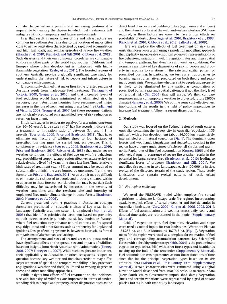
Our study was focused on the Sydney region of south easternAustralia, containing the largest city in Australia (population 4.35million), with urban development (about 36,000 km2) extensivelyintermingled with natural vegetation (Fig. 1). The dominant openforests and woodlands (Eucalyptus and Angophora species) in theregion have a dense understorey of sclerophyll shrubs and grami-noids. Rapid rates of fine fuel accumulation (Conroy, 1996) and therelatively frequent recurrence of severe fire weather results in thepotential for large, severe fires (Bradstock et al., 2010) leading tosignificant losses of property (Bradstock and Gill, 2001). Wemodelled fire regimes in two landscapes, each >100,000 ha in size,typical of the dissected terrain of the study region. These studylandscapes also contain typical patterns of local, urbandevelopment.
2.1. Fire regime modelling
We used the FIRESCAPE model which employs fire spreadalgorithms to simulate landscape-scale fire regimes incorporatingspatially-explicit effects of terrain, weather and fuel dynamics inAustralian landscapes (Cary, 2002; King et al., 2006, 2008, 2011).Effects of fuel accumulation and weather across daily, yearly anddecadal time scales are represented in the model (SupplementaryMaterial).
Grids of vegetation type, fuel dynamics, elevation and slopewere used as model inputs for two landscapes (Woronora Plateau154,287 ha, and Blue Mountains, 187,718 ha, (Fig. 1)). Vegetationmaps for the region were used as a template for estimation of fueltype and corresponding accumulation patterns. Dry SclerophyllForest with a shrubby understorey (Keith, 2004) is the predominantvegetation type (circa. 75%) with other forest types and heathlandsmaking up the bulk of the remainder (Supplementary Material).Fuel accumulation was represented as non-linear functions of timesince fire for the principal vegetation types based on in situempirical data (Raison et al., 1983; Conroy, 1996; SupplementaryMaterial). Terrain characteristics were estimated using a DigitalElevation Model developed from 1:50,000 scale, 10-m contour data(New South Wales Government unpublished data). Vegetation(fuel) and terrain variations were represented by a grid of squarepixels (100 m) in both case study landscapes.
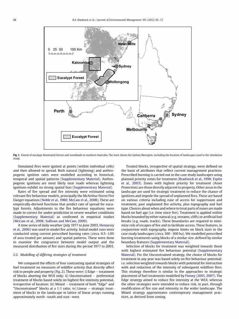
Fig. 1. Extent of eucalypt dominated forests and woodlands in southern Australia. The inset shows the Sydney Bioregion, including the location of landscapes used in the simulationstudy.
R.A. Bradstock et al. / Journal of Environmental Management 105 (2012) 66e7568
Simulated fires were ignited at points (within individual cells)and then allowed to spread. Both natural (lightning) and anthro-pogenic ignition rates were modelled according to historical,temporal and spatial patterns (Supplementary Material). Anthro-pogenic ignitions are most likely near roads whereas lightningignitions exhibit no strong spatial bias (Supplementary Material).
Rates of fire spread and fire intensity were estimated usingrelevant fire behaviourmodels, principally theMcArthur Forest FireDanger equations (Noble et al., 1980; McCaw et al., 2008). These areempirically-derived functions that predict rate of spread for euca-lypt forests. Adjustments to the fire behaviour equations weremade to correct for under-prediction in severe weather conditions(Supplementary Material) as confirmed in empirical studies(McCaw et al., 2008; Sullivan and McCaw, 2009).
A time series of daily weather (July 1977 to June 2003, Hennessyet al., 2006) was used to model fire activity. Initial model runs wereconducted using current prescribed burning rates (circa. 0.5e1.0%of area treated per annum) and spatial patterns. These were doneto examine the congruence between model output and themeasured distribution of fire sizes during the period 1977 to 2003.
2.2. Modelling of differing strategies of treatment
We compared the effects of four contrasting spatial strategies offuel treatment on measures of wildfire activity that directly affectrisk to people and property (Fig. 2). Thesewere: i) Edgee treatmentof blocks abutting the WUI only; ii) Unconstrained e preferentialtreatment of blocks based solely on highest fire intensity potential,irrespective of location; iii) Mixed e treatment of both “Edge” and“Unconstrained” blocks at a 1:1 ratio; iv) Linear e strategic treat-ment of blocks in the landscape in lattice of linear arrays runningapproximately northesouth and eastewest.
Treated blocks, irrespective of spatial strategy, were defined onthe basis of attributes that reflect current management practices.Prescribed burning is carried out in the case study landscapes usingplanned priority zones for treatment (Bradstock et al., 1998; Esplinet al., 2003). Zones with highest priority for treatment (AssetProtection) are those directlyadjacent to property. Other areas in thelandscape are used for strategic treatment to reduce the chance ofignitions and impede the spread of unplanned fires. These are basedon various criteria including ease of access for suppression andtreatment, past unplanned fire activity, plus topography and fueltype. Choices aboutwhenandwhere to treat parts of zones aremadebased on fuel age (i.e. time since fire). Treatment is applied withinblocks boundedbyeither natural (e.g. streams, cliffs) or artificial fuelbreaks (e.g. roads, tracks). These boundaries are required to mini-mize risk of escapes of fire and to facilitate access. These features, inconjunction with topography, impose limits on block sizes in thecase study landscapes (circa. 100e300 ha). Wemodelled prescribedburning treatments using blocks of a similar size, defined by similarboundary features (Supplementary Material).
Selection of blocks for treatment was weighted towards thosewith highest estimated fire behaviour potential (SupplementaryMaterial). For the Unconstrained strategy, the choice of blocks fortreatment in any year was based solely on fire behaviour potential:i.e. selectionweighted towards blocks with potential for interactionwith and reduction of the intensity of subsequent wildfires fires.This strategy therefore is similar to the approaches to strategicplacement of fuel treatments modelled by Finney (2001, 2007). TheEdge strategy aimed to reduce fire intensity at the WUI, whereasthe other strategies were intended to reduce risk, in part, throughmodification of fire size and intensity in the wider landscape. TheMixed strategy approximates contemporary management prac-tices, as derived from zoning.
Fig. 2. The layout of spatial strategies of simulated prescribed burning in two landscapes (Blue Mountains and Woronora Plateau) within the Sydney Bioregion of south easternAustralia. The shading indicates areas containing blocks used to define differing strategies. Edge blocks are located adjacent to urban areas (treated under Edge and Mixedstrategies), while non-edge blocks (treated under Unconstrained, Mixed and Linear strategies) are situated more remotely. For the Linear strategy, groups of blocks were selected toform continuous line segments.
R.A. Bradstock et al. / Journal of Environmental Management 105 (2012) 66e75 69
The Linear strategy was intended to represent the most prac-tically feasible and theoretically efficient way of optimizing fueltreatments in the case study landscapes. While theoretical studieshave explored the efficiency of various complex spatial designs oftreatments (e.g. Finney, 2001), such studies do not account for theconstraints of terrain and management access (i.e. roads andtracks) on the deployment of treatments. The case study land-scapes are highly dissected, with prominent ridge systemsbounded by cliffs of up to 100 m height, and steep valley slopes, asa function of the prevailing geomorphology (Doerr et al., 2006).Roads and tracks are mainly confined to broad, relatively flat ridgesystems, with restricted access to valleys. Intense wildfires in thestudy region have been shown to be most affected by fuel age (i.e.highest probability of mitigation of crown fires by fuel ages <5years) on ridges (Bradstock et al., 2010), especially where roads ortracks are present (Price and Bradstock, 2010). The Linear strategy,by focussing on preferential treatment of ridges, was designed tosuit these constraints of feasibility of implementation andefficacy.
The lattice design of the Linear strategy not only suited theimplicit nature of the landscape but also provided an opportunityto test theoretical predictions. Price (2012) showed that a griddedlattice design was highly effective in reducing wildfire size incomparison to other alternatives, such as random patterns. Bycontrast, Cary et al. (2009), using a multi-model approach, pre-dicted that targeted treatment of the edges of landscapes asopposed to the random patterns within the interior would providea more efficient reduction in risk to adjacent human assets. Thus,our study offered potential insights into the validity of these widelycontrasting alternative predictions.
Variations in treatment rate were achieved by varying thenumber of blocks selected (Supplementary Material). Effort wasvaried across five standard levels of available blocks (4, 8, 12, 16 and20%) for each spatial strategy. These percentages yielded differingnumbers of blocks treated for a given effort level among thestrategies resulting in differing overall proportions of the totallandscape treated (Supplementary Material). Thus, a large range ofoverall treatment rates (i.e. % of landscape treated per annum) wasexplored for the Unconstrained strategy whereas, only a relativelynarrow range of rates was explored for the Edge strategy, while theLinear and Mixed strategies dealt with an intermediate range oftreatment rates.
Fifty replicate simulations were completed for both landscapesusing the 26 year weather time series (i.e. an identical weather timeseries was used for all replicates). Daily timing and position ofunplanned ignitions was modelled stochastically in eachreplicate at fixed annual ignition rates and seasonal patterns(Supplementary Material).
2.3. Effects of climate change
We used two scenarios of 2050 fire weather for south easternAustralia, to model the effects of climate change on the performanceof the differing prescribed burning strategies. The scenarios assumedlow (Low) and high (High) rates of warming under climate change(Hennessy et al., 2006). These future scenarios involved adjustmentsof relevant variables (e.g. temperature, humidity, wind speed) for the1977e2003 daily time series of Sydney weather (Hennessy et al.,2006). Model runs were repeated for both climate change scenariosforall combinationsofprescribedburning rate and treatmentpattern.
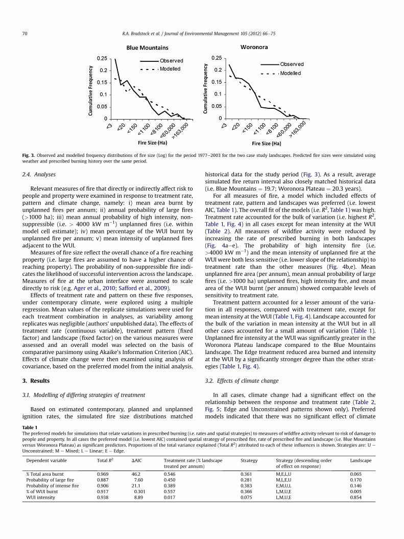
Fig. 3. Observed and modelled frequency distributions of fire size (Log) for the period 1977e2003 for the two case study landscapes. Predicted fire sizes were simulated usingweather and prescribed burning history over the same period.
R.A. Bradstock et al. / Journal of Environmental Management 105 (2012) 66e7570
2.4. Analyses
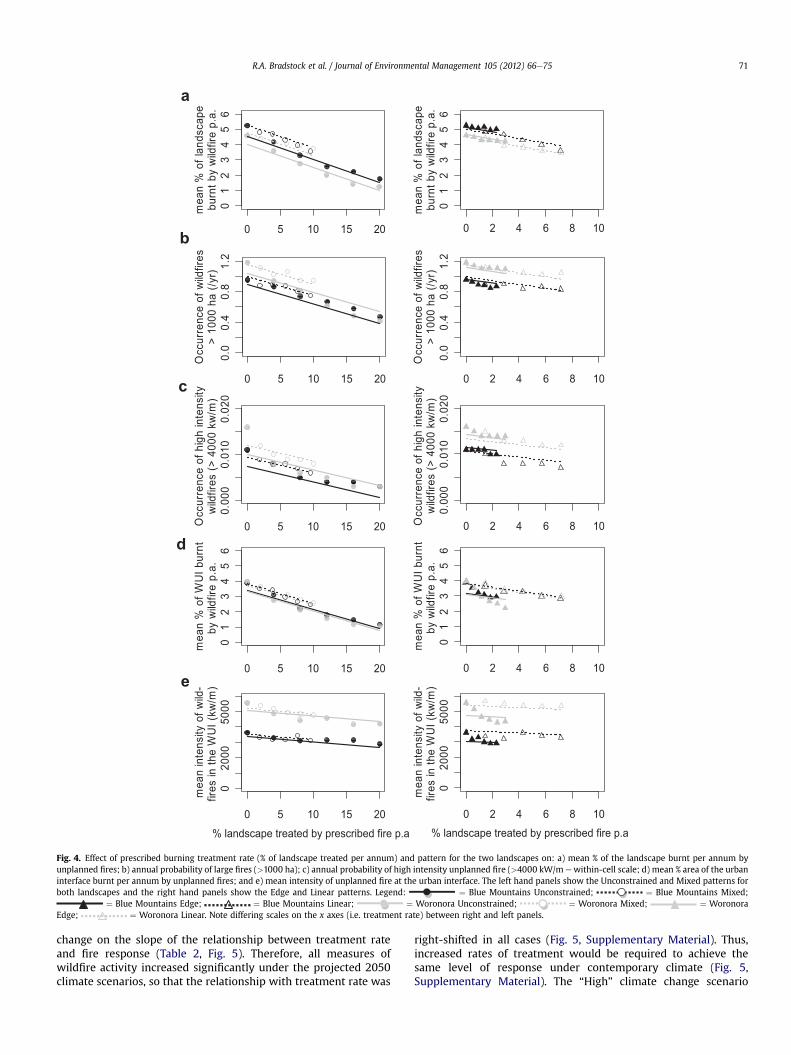
Relevant measures of fire that directly or indirectly affect risk topeople and property were examined in response to treatment rate,pattern and climate change, namely: i) mean area burnt byunplanned fires per annum; ii) annual probability of large fires(>1000 ha); iii) mean annual probability of high intensity, non-suppressible (i.e. > 4000 kW m�1) unplanned fires (i.e. withinmodel cell estimate); iv) mean percentage of the WUI burnt byunplanned fire per annum; v) mean intensity of unplanned firesadjacent to the WUI.
Measures of fire size reflect the overall chance of a fire reachingproperty (i.e. large fires are assumed to have a higher chance ofreaching property). The probability of non-suppressible fire indi-cates the likelihood of successful intervention across the landscape.Measures of fire at the urban interface were assumed to scaledirectly to risk (e.g. Ager et al., 2010; Safford et al., 2009).
Effects of treatment rate and pattern on these five responses,under contemporary climate, were explored using a multipleregression. Mean values of the replicate simulations were used foreach treatment combination in analyses, as variability amongreplicates was negligible (authors’ unpublished data). The effects oftreatment rate (continuous variable), treatment pattern (fixedfactor) and landscape (fixed factor) on the various measures wereassessed and an overall model was selected on the basis ofcomparative parsimony using Akaike’s Information Criterion (AIC).Effects of climate change were then examined using analysis ofcovariance, based on the preferred model from the initial analysis.
3. Results
3.1. Modelling of differing strategies of treatment
Based on estimated contemporary, planned and unplannedignition rates, the simulated fire size distributions matched
Table 1The preferred models for simulations that relate variations in prescribed burning (i.e. ratepeople and property. In all cases the preferred model (i.e. lowest AIC) contained spatial sversus Woronora Plateau) as significant predictors. Proportions of the total variance expUnconstrained; M e Mixed; L e Linear; E � Edge.
Dependent variable Total R2 DAIC Treatment rate (% ltreated per annum)
% Total area burnt 0.969 46.2 0.546Probability of large fire 0.887 7.60 0.450Probability of intense fire 0.906 21.1 0.389% of WUI burnt 0.917 0.301 0.557WUI intensity 0.938 8.89 0.017
historical data for the study period (Fig. 3). As a result, averagesimulated fire return interval also closely matched historical data(i.e. Blue Mountains ¼ 19.7; Woronora Plateau ¼ 20.3 years).
For all measures of fire, a model which included effects oftreatment rate, pattern and landscapes was preferred (i.e. lowestAIC, Table 1). The overall fit of the models (i.e. R2, Table 1) was high.Treatment rate accounted for the bulk of variation (i.e. highest R2,Table 1, Fig. 4) in all cases except for mean intensity at the WUI(Table 2). All measures of wildfire activity were reduced byincreasing the rate of prescribed burning in both landscapes(Fig. 4aee). The probability of high intensity fire (i.e.>4000 kW m�1) and the mean intensity of unplanned fire at theWUI were both less sensitive (i.e. lower slope of the relationship) totreatment rate than the other measures (Fig. 4b,e). Meanunplanned fire area (per annum), mean annual probability of largefires (i.e. >1000 ha) unplanned fires, high intensity fire, and meanarea of the WUI burnt (per annum) showed comparable levels ofsensitivity to treatment rate.
Treatment pattern accounted for a lesser amount of the varia-tion in all responses, compared with treatment rate, except formean intensity at theWUI (Table 1, Fig. 4). Landscape accounted forthe bulk of the variation in mean intensity at the WUI but in allother cases accounted for a small amount of variation (Table 1).Unplanned fire intensity at the WUI was significantly greater in theWoronora Plateau landscape compared to the Blue Mountainslandscape. The Edge treatment reduced area burned and intensityat the WUI by a significantly stronger degree than the other strat-egies (Table 1, Fig. 4).
3.2. Effects of climate change
In all cases, climate change had a significant effect on therelationship between the response and treatment rate (Table 2,Fig. 5; Edge and Unconstrained patterns shown only). Preferredmodels indicated that there was no significant effect of climate
s and spatial strategies) to measures of wildfire activity relevant to risk of damage totrategy of prescribed fire, rate of prescribed fire and landscape (i.e. Blue Mountainslained (Total R2) attributed to each of these influences is shown. Strategies are: U e
andscape Strategy Strategy (descending orderof effect on response)
Landscape
0.361 M,E,L,U 0.0650.281 M,L,E,U 0.1700.383 E,M,U,L 0.1460.366 L,M,U,E 0.0050.075 L,M,U,E 0.854
a
b
c
d
e
0 5 10 15 200
12
34
56
mea
n %
of l
ands
cape
burn
t by
wild
fire
p.a.
0 5 10 15 20
0.00
00.
010
0.02
0
Occ
urre
nce
of h
igh
inte
nsity
w
ildfir
es (>
400
0 kw
/m)
0 5 10 15 20
01
23
45
6
mea
n %
of W
UI b
urnt
by w
ildfir
e p.
a.
0 5 10 15 20
020
0050
00
% landscape treated by prescribed fire p.a
mea
n in
tens
ity o
f wild
-fir
es in
the
WU
I (kw
/m)
0 5 10 15 20
0.0
0.4
0.8
1.2
Occ
urre
nce
of w
ildfir
es>
1000
ha
(/yr)
0 2 4 6 8 10
0.0
0.4
0.8
1.2
Occ
urre
nce
of w
ildfir
es>
1000
ha
(/yr)
0 2 4 6 8 10
0.00
00.
010
0.02
0
Occ
urre
nce
of h
igh
inte
nsity
w
ildfir
es (>
400
0 kw
/m)
0 2 4 6 8 10
01
23
45
6
mea
n %
of W
UI b
urnt
by w
ildfir
e p.
a.
0 2 4 6 8 10
01
23
45
6
mea
n %
of l
ands
cape
burn
t by
wild
fire
p.a.
0 2 4 6 8 10
020
0050
00
% landscape treated by prescribed fire p.a
mea
n in
tens
ity o
f wild
-fir
es in
the
WU
I (kw
/m)
Fig. 4. Effect of prescribed burning treatment rate (% of landscape treated per annum) and pattern for the two landscapes on: a) mean % of the landscape burnt per annum byunplanned fires; b) annual probability of large fires (>1000 ha); c) annual probability of high intensity unplanned fire (>4000 kW/m ewithin-cell scale; d) mean % area of the urbaninterface burnt per annum by unplanned fires; and e) mean intensity of unplanned fire at the urban interface. The left hand panels show the Unconstrained and Mixed patterns forboth landscapes and the right hand panels show the Edge and Linear patterns. Legend: ¼ Blue Mountains Unconstrained; ¼ Blue Mountains Mixed;
¼ Blue Mountains Edge; ¼ Blue Mountains Linear; ¼ Woronora Unconstrained; ¼ Woronora Mixed; ¼ WoronoraEdge; ¼ Woronora Linear. Note differing scales on the x axes (i.e. treatment rate) between right and left panels.
R.A. Bradstock et al. / Journal of Environmental Management 105 (2012) 66e75 71
change on the slope of the relationship between treatment rateand fire response (Table 2, Fig. 5). Therefore, all measures ofwildfire activity increased significantly under the projected 2050climate scenarios, so that the relationship with treatment rate was
right-shifted in all cases (Fig. 5, Supplementary Material). Thus,increased rates of treatment would be required to achieve thesame level of response under contemporary climate (Fig. 5,Supplementary Material). The “High” climate change scenario
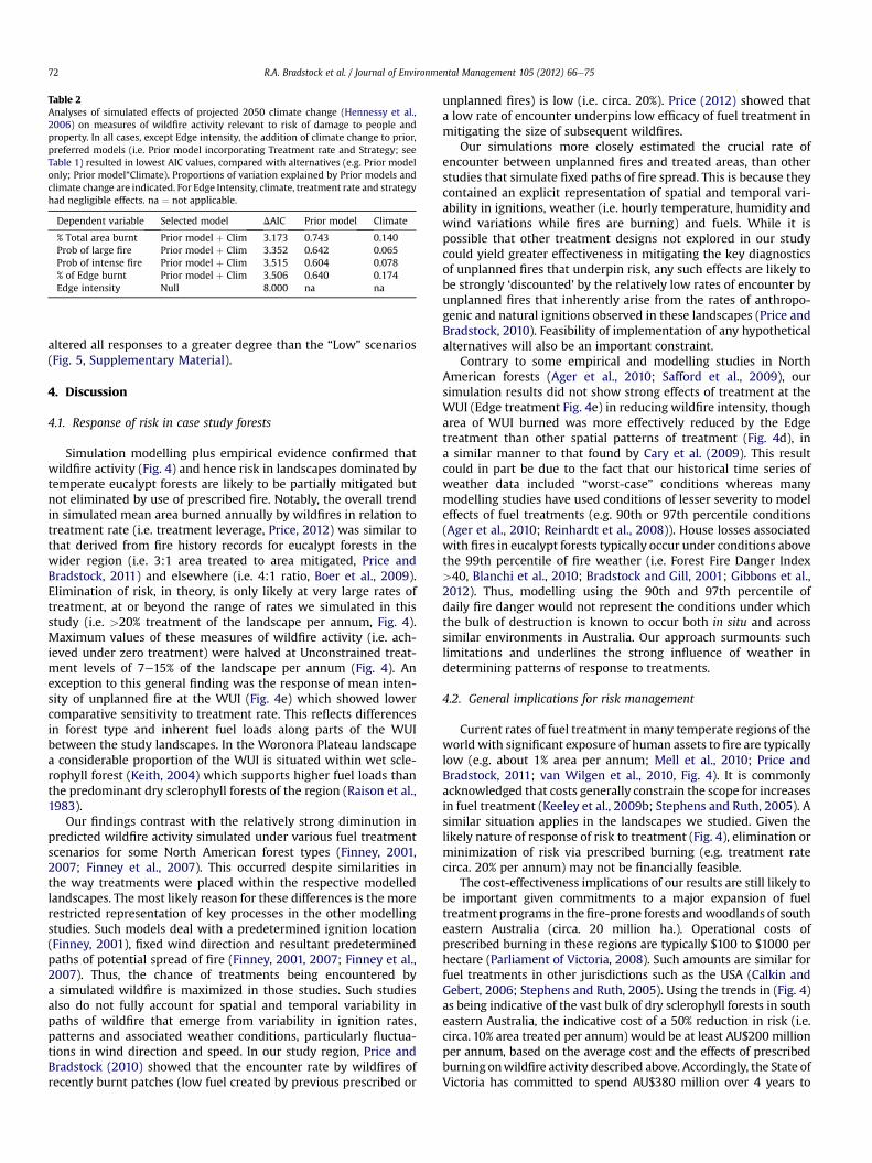
Table 2Analyses of simulated effects of projected 2050 climate change (Hennessy et al.,2006) on measures of wildfire activity relevant to risk of damage to people andproperty. In all cases, except Edge intensity, the addition of climate change to prior,preferred models (i.e. Prior model incorporating Treatment rate and Strategy; seeTable 1) resulted in lowest AIC values, compared with alternatives (e.g. Prior modelonly; Prior model*Climate). Proportions of variation explained by Prior models andclimate change are indicated. For Edge Intensity, climate, treatment rate and strategyhad negligible effects. na ¼ not applicable.
Dependent variable Selected model DAIC Prior model Climate
% Total area burnt Prior model þ Clim 3.173 0.743 0.140Prob of large fire Prior model þ Clim 3.352 0.642 0.065Prob of intense fire Prior model þ Clim 3.515 0.604 0.078% of Edge burnt Prior model þ Clim 3.506 0.640 0.174Edge intensity Null 8.000 na na
R.A. Bradstock et al. / Journal of Environmental Management 105 (2012) 66e7572
altered all responses to a greater degree than the “Low” scenarios(Fig. 5, Supplementary Material).
4. Discussion
4.1. Response of risk in case study forests
Simulation modelling plus empirical evidence confirmed thatwildfire activity (Fig. 4) and hence risk in landscapes dominated bytemperate eucalypt forests are likely to be partially mitigated butnot eliminated by use of prescribed fire. Notably, the overall trendin simulated mean area burned annually by wildfires in relation totreatment rate (i.e. treatment leverage, Price, 2012) was similar tothat derived from fire history records for eucalypt forests in thewider region (i.e. 3:1 area treated to area mitigated, Price andBradstock, 2011) and elsewhere (i.e. 4:1 ratio, Boer et al., 2009).Elimination of risk, in theory, is only likely at very large rates oftreatment, at or beyond the range of rates we simulated in thisstudy (i.e. >20% treatment of the landscape per annum, Fig. 4).Maximum values of these measures of wildfire activity (i.e. ach-ieved under zero treatment) were halved at Unconstrained treat-ment levels of 7e15% of the landscape per annum (Fig. 4). Anexception to this general finding was the response of mean inten-sity of unplanned fire at the WUI (Fig. 4e) which showed lowercomparative sensitivity to treatment rate. This reflects differencesin forest type and inherent fuel loads along parts of the WUIbetween the study landscapes. In the Woronora Plateau landscapea considerable proportion of the WUI is situated within wet scle-rophyll forest (Keith, 2004) which supports higher fuel loads thanthe predominant dry sclerophyll forests of the region (Raison et al.,1983).
Our findings contrast with the relatively strong diminution inpredicted wildfire activity simulated under various fuel treatmentscenarios for some North American forest types (Finney, 2001,2007; Finney et al., 2007). This occurred despite similarities inthe way treatments were placed within the respective modelledlandscapes. The most likely reason for these differences is the morerestricted representation of key processes in the other modellingstudies. Such models deal with a predetermined ignition location(Finney, 2001), fixed wind direction and resultant predeterminedpaths of potential spread of fire (Finney, 2001, 2007; Finney et al.,2007). Thus, the chance of treatments being encountered bya simulated wildfire is maximized in those studies. Such studiesalso do not fully account for spatial and temporal variability inpaths of wildfire that emerge from variability in ignition rates,patterns and associated weather conditions, particularly fluctua-tions in wind direction and speed. In our study region, Price andBradstock (2010) showed that the encounter rate by wildfires ofrecently burnt patches (low fuel created by previous prescribed or
unplanned fires) is low (i.e. circa. 20%). Price (2012) showed thata low rate of encounter underpins low efficacy of fuel treatment inmitigating the size of subsequent wildfires.
Our simulations more closely estimated the crucial rate ofencounter between unplanned fires and treated areas, than otherstudies that simulate fixed paths of fire spread. This is because theycontained an explicit representation of spatial and temporal vari-ability in ignitions, weather (i.e. hourly temperature, humidity andwind variations while fires are burning) and fuels. While it ispossible that other treatment designs not explored in our studycould yield greater effectiveness in mitigating the key diagnosticsof unplanned fires that underpin risk, any such effects are likely tobe strongly ‘discounted’ by the relatively low rates of encounter byunplanned fires that inherently arise from the rates of anthropo-genic and natural ignitions observed in these landscapes (Price andBradstock, 2010). Feasibility of implementation of any hypotheticalalternatives will also be an important constraint.
Contrary to some empirical and modelling studies in NorthAmerican forests (Ager et al., 2010; Safford et al., 2009), oursimulation results did not show strong effects of treatment at theWUI (Edge treatment Fig. 4e) in reducing wildfire intensity, thougharea of WUI burned was more effectively reduced by the Edgetreatment than other spatial patterns of treatment (Fig. 4d), ina similar manner to that found by Cary et al. (2009). This resultcould in part be due to the fact that our historical time series ofweather data included “worst-case” conditions whereas manymodelling studies have used conditions of lesser severity to modeleffects of fuel treatments (e.g. 90th or 97th percentile conditions(Ager et al., 2010; Reinhardt et al., 2008)). House losses associatedwith fires in eucalypt forests typically occur under conditions abovethe 99th percentile of fire weather (i.e. Forest Fire Danger Index>40, Blanchi et al., 2010; Bradstock and Gill, 2001; Gibbons et al.,2012). Thus, modelling using the 90th and 97th percentile ofdaily fire danger would not represent the conditions under whichthe bulk of destruction is known to occur both in situ and acrosssimilar environments in Australia. Our approach surmounts suchlimitations and underlines the strong influence of weather indetermining patterns of response to treatments.
4.2. General implications for risk management
Current rates of fuel treatment in many temperate regions of theworld with significant exposure of human assets to fire are typicallylow (e.g. about 1% area per annum; Mell et al., 2010; Price andBradstock, 2011; van Wilgen et al., 2010, Fig. 4). It is commonlyacknowledged that costs generally constrain the scope for increasesin fuel treatment (Keeley et al., 2009b; Stephens and Ruth, 2005). Asimilar situation applies in the landscapes we studied. Given thelikely nature of response of risk to treatment (Fig. 4), elimination orminimization of risk via prescribed burning (e.g. treatment ratecirca. 20% per annum) may not be financially feasible.
The cost-effectiveness implications of our results are still likely tobe important given commitments to a major expansion of fueltreatment programs in the fire-prone forests andwoodlands of southeastern Australia (circa. 20 million ha.). Operational costs ofprescribed burning in these regions are typically $100 to $1000 perhectare (Parliament of Victoria, 2008). Such amounts are similar forfuel treatments in other jurisdictions such as the USA (Calkin andGebert, 2006; Stephens and Ruth, 2005). Using the trends in (Fig. 4)as being indicative of the vast bulk of dry sclerophyll forests in southeastern Australia, the indicative cost of a 50% reduction in risk (i.e.circa. 10% area treated per annum) would be at least AU$200 millionper annum, based on the average cost and the effects of prescribedburning onwildfire activity described above. Accordingly, the State ofVictoria has committed to spend AU$380 million over 4 years to
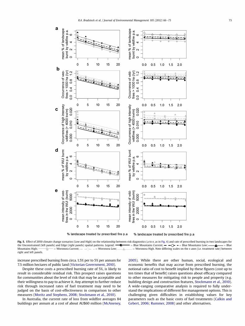
Fig. 5. Effect of 2050 climate change scenarios (Low and High) on the relationship between risk diagnostics (a to e, as in Fig. 4) and rate of prescribed burning in two landscapes forthe Unconstrained (left panels) and Edge (right panels) spatial patterns. Legend: ¼ Blue Mountains Current; ¼ Blue Mountains Low; ¼ BlueMountains High; ¼ Woronora Current; ¼ Woronora Low; ¼ Woronora High. Note differing scales on the x axes (i.e. treatment rate) betweenright and left panels.
R.A. Bradstock et al. / Journal of Environmental Management 105 (2012) 66e75 73
increase prescribed burning from circa. 1.5% per to 5% per annum for7.5 million hectares of public land (Victorian Government, 2010).
Despite these costs a prescribed burning rate of 5%, is likely toresult in considerable residual risk. This prospect raises questionsfor communities about the level of risk that may be acceptable andtheir willingness to pay to achieve it. Any attempt to further reducerisk through increased rates of fuel treatment may need to bejudged on the basis of cost-effectiveness in comparison to othermeasures (Moritz and Stephens, 2008; Stockmann et al., 2010).
In Australia, the current rate of loss from wildfire averages 84buildings per annum at a cost of about AU$60 million (McAneney,
2005). While there are other human, social, ecological andeconomic benefits that may accrue from prescribed burning, thenotional ratio of cost to benefit implied by these figures (cost up toten times that of benefit) raises questions about efficacy comparedto other measures for mitigating risk to people and property (e.g.building design and construction features, Stockmann et al., 2010).A wide-ranging comparative analysis is required to fully under-stand the implications of different fire management options. This ischallenging given difficulties in establishing values for keyparameters such as the basic costs of fuel treatments (Calkin andGebert, 2006; Rummer, 2008) and other alternatives.
R.A. Bradstock et al. / Journal of Environmental Management 105 (2012) 66e7574
It is commonly argued that the cost of fuel treatment can berecouped via a subsequent reduction in future suppression costs(Stephens and Ruth, 2005). The results indicate that in Australianforests, suppression costs per unit area would need to be higherthan those for prescribed burning by a factor of three or more toachieve an overall saving. Current information indicates, however,that prescribed burning and suppression costs per hectare aresimilar in Australian eucalypt forests (Parliament of Victoria, 2008).Therefore, expenditure on fuel reduction will only partially beoffset by savings on suppression. Expansion of fuel treatment willrequire significant additional costs to those currently incurred onfire management infrastructure and operations (e.g. Reinhardtet al., 2008).
4.3. Climate change implications
The simulated results for projected climatic conditions in 2050confirm the strong influence of weather on wildfire activity andensuing risk (Fig. 5). The effects of a more severe future climate didnot, however, strongly affect the slope of the relationship betweenrate of treatment and wildfire activity (Fig. 5). Rather, the level ofwildfire activity was elevated overall, irrespective of treatmentrate, under future climate as opposed to contemporary climate(Fig. 5).
The impending effect of climate change (e.g. Fig. 5) maycompound the difficulty of achieving substantial reductions in riskthrough fuel treatment. An increase of five-fold or more in the rateof fuel treatment (i.e. from circa. 1.0% of area currently treated perannum) would be required to counteract the effects of the mostsevere scenario of 2050 climate change on measures such as meanarea and intensity of unplanned fire (Fig. 5a,d). Recently recom-mended increases in treatment (e.g. expansion to a 5% treatmentrate; Teague et al., 2010) may therefore be insufficient to counteractthe impending effects of a warmer and drier climate in the mediumterm (Fig. 5). This increases the necessity to understand the cost-effectiveness of alternative methods of risk reduction, particularlythose focused within the built environment.
Fuel dynamics were held constant in our simulations. Therefore,our results underscore the impacts of direct changes in future fireweather, not the indirect effects via altered vegetation and fuelsresulting from a changing climate. A more detailed understandingof the response of risk to treatment will require a deeper explora-tion of the effects of interactions between weather and fueldynamics. Such insights are urgently needed to estimate thepotential for climate change-driven alterations to wildfire activityin differing ecosystems.
5. Conclusions
The sensitivity of risk to fuel treatment rates is pivotal to themanagement of fire in all of the world’s fire-prone regions. Riskmay be reduced but not eliminated by management interventionsin temperate eucalypt forests. Feasible fuel treatment strategies arelikely to leave considerable residual risk in many Australianforested ecosystems and this risk may be expected to increase inthe future. Explicit recognition of this fundamental conclusion andits attendant consequences, including costs, will be needed to builda more comprehensive approach to the management of risks topeople and their infrastructure.
Acknowledgements
Funding for modelling was provided by the New South WalesDepartment of Environment, Climate Change and Water as part ofClimate Change Impacts and Adaptation Research Project 050831.
Appendix A. Supplementary material
Supplementary material associated with this article can befound, in the online version, at doi:10.1016/j.jenvman.2012.03.050.
References
Ager, A.A., Vaillant, N.M., Finney, M.A., 2010. A comparison of landscape fueltreatment strategies to mitigate wildland fire risk in the urban interface andpreserve old forest structure. Forest Ecology & Management 259, 1556e1570.
Blanchi, R., Lucas, C., Leonard, J., Finkele, K., 2010. Meteorological conditions andwildfire-related house loss in Australia. International Journal of Wildland Fire19, 914e926.
Boer, M.M., Sadler, R.J., Wittkuhn, R.S., McCaw, L., Grierson, P.F., 2009. Long-termimpacts of prescribed burning on regional extent and incidence of wildfires eevidence from 50 years of active fire management in SW Australian forests.Forest Ecology & Management 259, 132e142.
Bowman, D.M.J.S., Balch, J.K., Artaxo, P., Bond, W.J., Carlson, J.M., Cochrane, M.A.,D’Antonio, C.M., DeFries, R.S., Doyle, J.C., Harrison, S.P., Johnston, F.H.,Keeley, J.E., Krawchuk, M.A., Kull, C.A., Marston, J.B., Moritz, M.A., Prentice, I.C.,Roos, C.I., Scott, A.C., Swetnam, T.W., van der Werf, G.R., Pyne, S.J., 2009. Fire inthe earth system. Science 324, 481e484.
Bradstock, R.A., 2010. A biogeographic model of fire regimes in Australia:contemporary and future implications. Global Ecology & Biogeography 19,145e158.
Bradstock, R.A., Gill, A.M., 2001. Living with fire and biodiversity at the urban edge:in search of a sustainable solution to the human protection problem in southernAustralia. Journal of Mediterranean Ecology 2, 179e195.
Bradstock, R.A., Gill, A.M., Kenny, B., Scott, J., 1998. Bushfire risk at the urbaninterface derived from historical weather records: consequences for use ofprescribed fire in the Sydney region of south-eastern Australia. Journal ofEnvironmental Management 52, 259e271.
Bradstock, R.A., Hammill, K., Collins, L., Price, O., 2010. Effects of weather, fuel andterrain on fire severity in topographically diverse landscapes of south-easternAustralia. Landscape Ecology 25, 607e619.
Calkin, D., Gebert, K., 2006. Modeling fuel treatment costs on forest service lands inthe western United States. Western Journal of Applied Forestry 21, 217e221.
Cary, G.J., Flannigan, M.D., Keane, R.E., Bradstock, R.A., Davies, I.D., Lenihan, J.M., Li, C.,Logan, K.A., Parson, R.A., 2009. Relative importance of fuel management, ignitionmanagement and weather for area burned: evidence from five landscape-fire-succession models. International Journal of Wildland Fire 18, 147e156.
Cary, G.J., 2002. Importance of a changing climate for fire regimes in Australia. In:Bradstock, R.A., Williams, J.E., Gill, A.M. (Eds.), Flammable Australia: The FireRegimes and Biodiversity of a Continent. Cambridge University Press, Cam-bridge, pp. 26e46.
Conroy, R.J., 1996. To burn or not burn? A description of the history, nature andmanagement of bushfires within Ku-Ring-Gai chase national park. Proceedingsof the Linnean Society of New South Wales 116, 80e96.
Doerr, S.H., Shakesby, R.A., Blake, W.H., Chafer, C.J., Humphreys, G.S., Wallbrink, P.J.,2006. Effects of differing wildfire severities on soil wettability and implicationsfor hydrological responses. Journal of Hydrology 319, 295e311.
Esplin, B., Gill, A.M., Enright, N.J., 2003. Report of the Inquiry into the 2002e2003Victorian Bushfires. Victorian Government Department of Premier and Cabinet,Melbourne.
Finney, M.A., 2001. Design of regular landscape fuel treatment patterns for modi-fying fire growth and behavior. Forest Science 47, 219e228.
Finney, M.A., 2005. The challenge of quantitative risk analysis for wildland fire.Forest Ecology & Management 211, 97e108.
Finney, M.A., 2007. A computational method for optimising fuel treatment loca-tions. International Journal of Wildland Fire 16, 702e711.
Finney, M.A., Selia, R.C., McHugh, C.W., Ager, A.A., Bahro, B., Agee, J.K., 2007.Simulation of long-term landscape-level fuel treatment effects on large wild-fires. International Journal of Wildland Fire 16, 712e727.
Gibbons, P., van Bommel, L., Gill, A.M., Cary, G., Driscoll, D.A., Bradstock, R.A.,Knight, E., Moritz, M., Stephens, S.L., Lindenmayer, D.B., 2012. Land manage-ment practices associated with house loss in wildfires. Plos ONE, e29212.doi:10.1371/journal.pone.0029212.
Gill, A.M., 2005. Landscape fires as social disasters: an overview of the bushfireproblem. Global Environmental Change B. Environmental Hazards 6, 65e80.
Hennessy, K.J., Lucas, C., Nicholls, N., Bathols, J.M., Suppiah, R., Ricketts, J.R., 2006.Climate Change Impacts on Fire-Weather in South-east Australia. Report C/1061, CSIRO, Melbourne.
Keeley, J.E., Zedler, P.H., 2009. Large, high intensity fire events in southern Californiashrublands: debunking the fine-grained age-patch model. Ecological Applica-tions 19, 69e94.
Keeley, J.E., Safford, H., Fotheringham, C.J., Franklin, J., Moritz, M., 2009a. The 2007southern California wildfires: lessons in complexity. Journal of Forestry 107,287e296.
Keeley, J.E., Aplet, G.H., Christensen, N.L., Conard, S.G., Johnson, E.A., Omi, P.N.,Peterson, D.L., Swetnam, T.W., 2009b. Ecological foundations for fire manage-ment in North American forest and shrubland ecosystems. U.S. Department ofAgriculture, Forest Service, Pacific Northwest Research Station, General. Tech-nical. Report PNW-GTR-779.
R.A. Bradstock et al. / Journal of Environmental Management 105 (2012) 66e75 75
Keeley, J.E., Bond, W.J., Bradstock, R.A., Pausas, J.G., Rundel, P.W., 2011. Fire Ecology,Evolution and Management in Mediterranean Climate Ecosystems. CambridgeUniversity Press.
Keith, D., 2004. Ocean Shores to Desert Dunes: The Native Vegetation of New SouthWales and the ACT. New South Wales Department of Environment andConservation, Sydney, New South Wales.
King, K., Cary, G., Bradstock, R.A., Chapman, J., Pyrke, A., Marsden-Smedley, J., 2006.Simulation of prescribed burning strategies in south west Tasmania, Australia:effects on unplanned fires, fire regimes and ecological management values.International Journal of Wildland Fire 15, 527e540.
King, K.J., Bradstock, R.A., Cary, G., Chapman, J., Marsden-Smedley, J., 2008. Aninvestigation into the relative importance of fine scale fuel mosaics on reducingfire risk in south west Tasmania, Australia. International Journal of WildlandFire 17, 421e430.
King, K.J., de Ligt, R.M., Cary, G.J., 2011. Fire and carbon dynamics under climatechange in south eastern Australia: insights from FullCAM and FIRESCAPEmodelling. International Journal of Wildland Fire 20, 563e577.
Lowell, K., Shamir, R., Siqueira, A., White, J., O’Connor, A., Butcher, G., Garvey, M.,Niven, M., 2009. Assessing the capabilities of geospatial data to map builtstructures and evaluate their bushfire threat. International Journal of WildlandFire 18, 1010e1020.
McAneney, J., 2005. Australian bushfire: quantifying and pricing the risk to resi-dential properties. In: Morrison, R.J., Quin, S., Bryant, E.A. (Eds.), Proceedings ofa Symposium of the Planning for Natural Hazards e How Can We Mitigate theImpacts? University of Wollongong, Wollongong, pp. 13e21.
McCaw, W.L., Gould, J.S., Cheney, N.P., 2008. Existing fire behaviour models under-predict the rate of spread of summer fires in open jarrah (Eucalyptus marginata)forest. Australian Forestry 71, 16e26.
Mell, W.E., Manzello, S.L., Maranghides, A., Butry, D., Rehm, R.G., 2010. Thewildland-urban interface fire problem e current approaches and researchneeds. International Journal of Wildland Fire 19, 238e251.
Moritz, M.A., Stephens, S.L., 2008. Fire and sustainability: considerations for Cal-ifornia’s altered future climate. Climate Change 87 (Suppl. 1), S265eS271.doi:10.1007/s10584-007-9361-1.
Noble, I.R., Bary, G.A.V., Gill, A.M., 1980. McArthur’s fire-danger meters expressed asequations. Australian Journal of Ecology 5, 201e203.
Parliament of Victoria, 2008. Inquiry into the Impact of Public Land Management onBushfires in Victoria. Report of Victorian Parliament, Environment and NaturalResources Committee, Melbourne.
Price, O.F., 2012. The drivers of effectiveness of prescribed fire treatment. ForestScience 58.
Price, O.F., Bradstock, R.A., 2010. The effect of fuel age on the spread of fire insclerophyll forest in the Sydney region of Australia. International Journal ofWildland Fire 19, 35e45.
Price, O.F., Bradstock, R.A., 2011. The influence of weather and fuel management onthe annual extent of unplanned fires in the Sydney region of Australia. Inter-national Journal of Wildland Fire 20, 142e151.
Raison, R.J., Woods, P.V., Khanna, P.K., 1983. Dynamics of fine fuels in recurrentlyburnt eucalypt forests. Australian Forestry 46, 294e302.
Reinhardt, E.D., Keane, R.E., Calkin, D.E., Cohen, J.D., 2008. Objectives and consid-erations for wildland fuel treatment in forested ecosystems of the interiorwestern United States. Forest Ecology & Management 256, 1997e2006.
Rummer, B., 2008. Assessing the cost of fuel reduction treatments: a critical review.Forest Policy & Economics 10, 355e362.
Safford, H.D., Schmidt, D.A., Carlson, C.H., 2009. Effects of fuel treatments on fireseverity in an area of wildland-urban interface, Angora Fire, Lake Tahoe Basin,California. Forest Ecology & Management 258, 773e787.
Stephens, S.L., Ruth, L.W., 2005. Federal forest-fire policy in the United States.Ecological Applications 15, 532e542.
Stephens, S.L., Adams, M.A., Handmer, J., Kearns, F.R., Leicester, B., Leonard, J.,Moritz, M.A., 2009a. Urban-wildland fires: how California and other regionsof the US can learn from Australia. Environmental Research Letters 4, 014010,5 pp.
Stephens, S.L., Moghaddas, J.J., Edminster, C., Fiedler, C.E., Haase, S.,Harrington, M., Keeley, J.E., Knapp, E.E., McIver, J.D., Metlen, K., Skinner, C.N.,Youngblood, A., 2009b. Fire treatment effects on vegetation structure, fuels,and potential fire severity in western U.S. forests. Ecological Applications 19,305e320.
Stockmann, K., Burchfield, J., Calkin, D., Venn, T., 2010. Guiding preventative wild-land fire mitigation policy and decisions with an economic modeling system.Forest Policy & Economics 12, 147e154.
Sullivan, A., McCaw, L., 2009. Fire Behaviour Investigation. Victorian 2009 BushfireResearch Response. Final Report, Bushfire Co-operative Research Centre,Melbourne.
Syphard, A.D., Radeloff, V.C., Hawbaker, T.J., Stewart, S.I., 2009. Conservation threatsdue to human-caused increases in fire frequency in Mediterranean-climateecosystems. Conservation Biology 23, 758e769.
Teague, B., McLeod, R., Pascoe, S., 2010. 2009 Victorian Bushfires Royal Commission.Final Report, Parliament of Victoria, Victoria.
van Wilgen, B.W., Forsyth, G.G., de Klerk, H., Das, S., Khuluse, S., Schmitz, P., 2010.Fire management in Mediterranean-climate shrublands: a case study from theCape fynbos, South Africa. Journal of Applied Ecology 47, 631e638.
Victorian Government, 2010. Making Victoria Fire-ready. State of Victoria.Vos, F., Rodriguez, J., Below, R., Guha-Sapir, D., 2010. Annual Disaster Statistical
Review 2009: The Numbers and Trends. CRED, Brussels.Westerling, A.L., Hidalgo, H.G., Cayan, D.R., Swetnam, T.W., 2006. Warming and
earlier spring increase western U.S. forest wildfire activity. Science 313,940e943.