what is an estuary - ccma.vic.gov.au · what do you get when you mix freshwater and saltwater?...
TRANSCRIPT

What do you get when you mix freshwater and saltwater?
An estuary! Answer
Question
“It is not a river”
“It is not the ocean”
“It is something in-between that is completely unique”
WHAT IS AN ESTUARY?
Get involved! We are all estuary managers! Keep abreast of anything happening in and around your estuary.
“It is not the ocean”
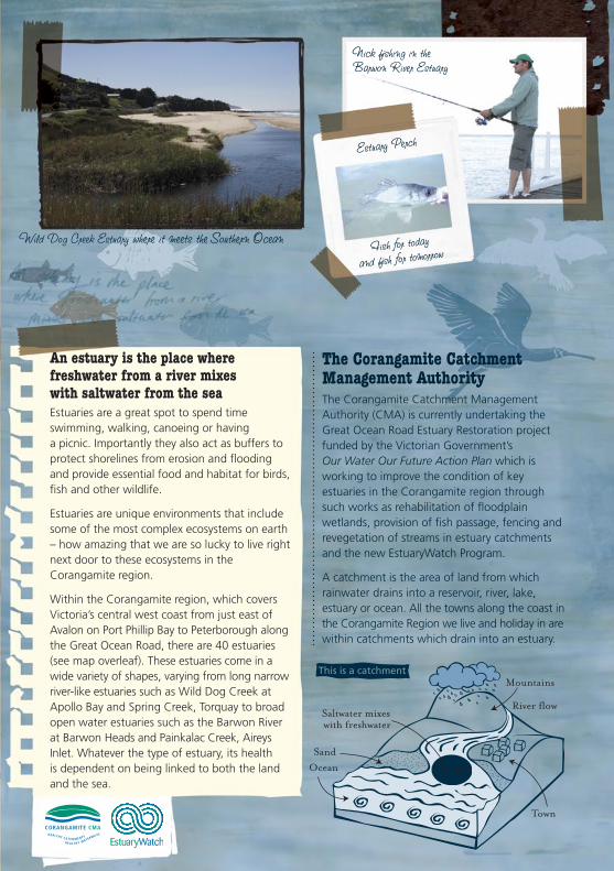
The Corangamite Catchment Management Authority (CMA) is currently undertaking the Great Ocean Road Estuary Restoration project funded by the Victorian Government’s Our Water Our Future Action Plan which is working to improve the condition of key estuaries in the Corangamite region through such works as rehabilitation of floodplain wetlands, provision of fish passage, fencing and revegetation of streams in estuary catchments and the new EstuaryWatch Program.
A catchment is the area of land from which rainwater drains into a reservoir, river, lake, estuary or ocean. All the towns along the coast in the Corangamite Region we live and holiday in are within catchments which drain into an estuary.
An estuary is the place where freshwater from a river mixes with saltwater from the seaEstuaries are a great spot to spend time swimming, walking, canoeing or having a picnic. Importantly they also act as buffers to protect shorelines from erosion and flooding and provide essential food and habitat for birds, fish and other wildlife.
Estuaries are unique environments that include some of the most complex ecosystems on earth – how amazing that we are so lucky to live right next door to these ecosystems in the Corangamite region.
Within the Corangamite region, which covers Victoria’s central west coast from just east of Avalon on Port Phillip Bay to Peterborough along the Great Ocean Road, there are 40 estuaries (see map overleaf). These estuaries come in a wide variety of shapes, varying from long narrow river-like estuaries such as Wild Dog Creek at Apollo Bay and Spring Creek, Torquay to broad open water estuaries such as the Barwon River at Barwon Heads and Painkalac Creek, Aireys Inlet. Whatever the type of estuary, its health is dependent on being linked to both the land and the sea.
The Corangamite Catchment Management Authority
Wild Dog Creek Estuary where it meets the Southern Ocean
Nick fishing in the Barwon River Estuary
Fish for today
and fish for tomorrow
Estuary Perch

Ros and Tim Monitoring the water quality in Painkalac Creek Estuary
Apollo Bay Landcare Grouprehabilitating Wild Dog Creek Estuary
School Kids learning about their local estuary
GET
INVOLVEDBecome involved in EstuaryWatch today. Contact the Corangamite CMA’s EstuaryWatch Coordinator at [email protected] or telephone (03) 5232-9100 or see the EstuaryWatch section of the Corangamite CMA website www.ccma.vic.gov.au/programs/EstuaryWatchOne.htm
What is EstuaryWatch?We know that estuaries here in the Corangamite Region are interesting and unique, but there is also a lot we don’t know about them. EstuaryWatch is an initiative of the Corangamite CMA and the Western Coastal Board aiming to help local communities learn more about their estuary - how it functions and how healthy it is and use this information to help conserve their estuaries into the future! EstuaryWatch will do this by:
Step One - EstuaryWatch Monitoring
Helping you and other locals gather information about your estuaries through an EstuaryWatch Monitoring Program. EstuaryWatch monitoring will be a means of scientifically measuring the condition or ‘health’ of your estuary and to understand changes that occur. Getting involved in EstuaryWatch monitoring can be as simple as taking a photo when you see something unusual in the estuary and sending it to the Corangamite CMA; or as fun as getting involved in monitoring bird life, the vegetation surrounding your estuary or the physical and chemical properties of the water within your estuary.
Step Two - EstuaryWatch Education
Providing fun opportunities to learn amazing information about your local estuary. EstuaryWatch Education activities will be run in estuaries right along the coast on all sorts of interesting topics such as the plants and animals you find living there, how you can help conserve your local estuary and how an estuary changes throughout the seasons of the year. Anyone and everyone is most welcome to join in and activities will be run for school groups, local community members and visitors to the region
Step Three - Decision Making
Using the information collected through the EstuaryWatch Monitoring Program and valuable community knowledge and skills developed through EstuaryWatch Education in decision making on estuary management.
Plant indigenous plants

Curdies Inlet Estuary
16kmApproximate
estuary length
1124km2
Catchment Area
Interesting Fact:
The saltmarsh and grasslands surrounding the estuary provide habitat for one of Australia’s rarest birds, the Orange-Bellied Parrot.
Gellibrand River Estuary
8kmApproximate
estuary length
1184km2
Catchment Area
Interesting Fact:
Flows directly into the Twelve Apostles Marine National Park.
Aire River Estuary
8kmApproximate
estuary length
280km2
Catchment Area
Interesting Fact:
The shallow salty wetlands of the estuary are very rare in Victoria.
Barham River Estuary
2kmApproximate
estuary length
79.5km2
Catchment Area
Interesting Fact:
A meandering tidal waterway of State significance due to its geology.
Royal Spoonbill
David sharing his knowledge of the cultural values of estuaries
Little Pied Cormorant
Jessie and his kids bird watching at Barham River Estuary
ESTUARIESof the CoRANGAMiTE
region
Swam
p H
arrier

Wild Dog Creek Estuary
1kmApproximate
estuary length
19.9km2
Catchment Area
Interesting Fact:
Breeding site for the small and shy Hooded Plover which is a vulnerable species in Victoria.
Kennet River Estuary
1kmApproximate
estuary length
20km2
Catchment Area
Interesting Fact:
Home to the Australian Grayling which is the fish species of the greatest conservation need in the Otway region.
Wye River Estuary
1kmApproximate
estuary length
24.6km2
Catchment Area
Interesting Fact:
The estuary is home to the vulnerable Tasmanian Mudfish which bury themselves beneath logs or stones during dry summers.
Apollo Bay Landcare Group

A beautiful day down at the Erskine River Estuary
St George River Estuary
2kmApproximate
estuary length
33.9km2
Catchment Area
Interesting Fact:
The only estuary in the Corangamite Region to be listed as being in a ‘near-pristine condition’.
Erskine River Estuary
1kmApproximate
estuary length
30.4km2
Catchment Area
Interesting Fact:
Around 80% of the estuary’s catchment area is in the Great Otway National Park.
Painkalac Creek Estuary
3kmApproximate
estuary length
61km2
Catchment Area
Interesting Fact:
A beautiful coastal lagoon system which attracts the spotted green frog and eastern banjo frog (Pobblebonk).
Anglesea River Estuary
4kmApproximate
estuary length
125km2
Catchment Area
Interesting Fact:
Extensive boardwalks, bridges and trails provide many opportunities to get up close to the estuary.
Taking time out to enjoy Painkalac Creek Estuary
Boating in the Anglesea River Estuary

Mia and Felix playing down at the Barwon River Estuary
Spring Creek Estuary
4kmApproximate
estuary length
57km2
Catchment Area
Interesting Fact:
The estuary is bordered by the Spring Creek Reserve which contains unique and rare Moonah Woodlands and Bellarine Yellowgums.
Thompsons Creek Estuary
6kmApproximate
estuary length
305km2
Catchment Area
Interesting Fact:
Part of the important Karaaf Wetlands which are rich in local cultural history.
Barwon River Estuary
19kmApproximate
estuary length
8590km2
Catchment Area
Interesting Fact:
From the internationally significant wetland at Lake Connewarre to the sea, the Barwon estuary supports the westernmost occurrence of the White Mangrove in Victoria.
For more information on any of the estuaries in the
Corangamite Region contact the EstuaryWatch Coordinator
at [email protected] or telephone
(03) 5232-9100 for an Estuary Information Sheet.
Scale of Map

Estuarywatch is funded by Further InformationThe more people that get involved in EstuaryWatch the better informed we will be and the better chance we have of keeping our estuaries looking and feeling healthy into the future. For further information contact the Corangamite CMA’s EstuaryWatch Coordinator at [email protected] or telephone (03) 5232-9100 or see the EstuaryWatch section of the Corangamite CMA website www.ccma.vic.gov.au/programs/EstuaryWatchOne.htm
Get involved! We are all estuary managers! Keep abreast of anything happening in and around your estuary.
Organisations involved in Estuarywatch