wethersfield & rocky hill, connecticutrockyhillct.gov/silas_deane_highway_final_report.pdf ·...
TRANSCRIPT

PREPARED BY:PREPARED BY: IN ASSOCIATION WITH:IN ASSOCIATION WITH:
IMPLEMENTATION MASTER PLAN & DESIGN GUIDELINES FOR THE
SILAS DEANE HIGHWAY
IMPLEMENTATION MASTER PLAN & DESIGN GUIDELINES FOR THE
SILAS DEANE HIGHWAY
WETHERSFIELD & ROCKY HILL, CONNECTICUTWETHERSFIELD & ROCKY HILL, CONNECTICUT

Footer goes here
TABLE OF CONTENTSTABLE OF CONTENTSINTRODUCTION…………………………………………………………………………………..I-
LAND USE……………………………………………………………………………………………..L-
LAND USE RECOMMENDATIONS……………………
TRANSPORTATION……………………………………………………………………………..T-
TRANSPORTATION………….
TRANSPORTATION…………….
TRANSPORTATION………….
TRANSPORTATION…………….
TRANSPORTATION………….
TRANSPORTATION…………….
BRAND IMAGE……………………………………………………………………………………B
STREETSCAPE……………………………………………………………………………………….S-
STREETSCAPE KEY MAP………………
TYPICAL SECTIONS BY AREA……….
TYPICAL SECTIONS BY AREA…..
PLANT PALLET…………..
WALKS………….
PARKING BUFFERS………
STREETSCAPE FURNITURE…………..
CROSSWALKS……………….
ARCHITECTURE………………………………………………………………………………………………..A-
ARCHITECTURE…………………
ARCHITECTURE…………………
ARCHITECTURE…………………
ZONING…………………………………………………………………………………………………………….Z-
ZONING…………
ZONING…………
REINVESTMENT SITES……………………………………………………………………………………..R-
REINVESTMENT SITES……………
TOWN CENTER- WETHERSFIELD…………
TOWN CENTER- ROCKY HILL……………………
2006- SILAS DEANE REVITALIZATION COMMITTEE2006- SILAS DEANE REVITALIZATION COMMITTEE
ROCKY HILLMayor Anthony LaRosaEx –Officio/Town Manager Barbara Gilbert
Staff –Jeanne Webb Chavez – Economic Development CoordinatorJames Sollmi, P.E. – Town EngineerChairman Larry deBearCouncilman Rocco SanzoCouncilwoman Barbara SurwiloDr. Ann Flandermeyer -Economic Development Commission John Harvey - Rocky Hill Chamber
Silas Deane BusinessesDavid Schweitzer P.E -HNTB
Melroy D’Costa -Hampton Inn Rob St. John - F.X. Messina
WETHERSFIELDMayor Russ MorinEx –Officio/Town Manager Bonnie Therrien
Staff –Peter Gillespie – Economic Development DirectorMike Turner, P.E. – Town Engineer
Betty Rosania – Economic Development and Improvement CommissionDave Edwards – Planning and Zoning CommissionCarmela Moore – Chamber of CommerceLeonardo Gugliotti – Silas Deane Highway Business John Lepper – Resident and Tree WardenSteve Foote – ResidentBernadine Franco - Resident
CONSULTING TEAMFuss & O’Neill, Inc. – Prime Consultant
Ferrero Hixon Associates
RKG Associates
James Vance and Associates
Planimetrics
Moser Pilon Nelson
In Association WithPrepared By
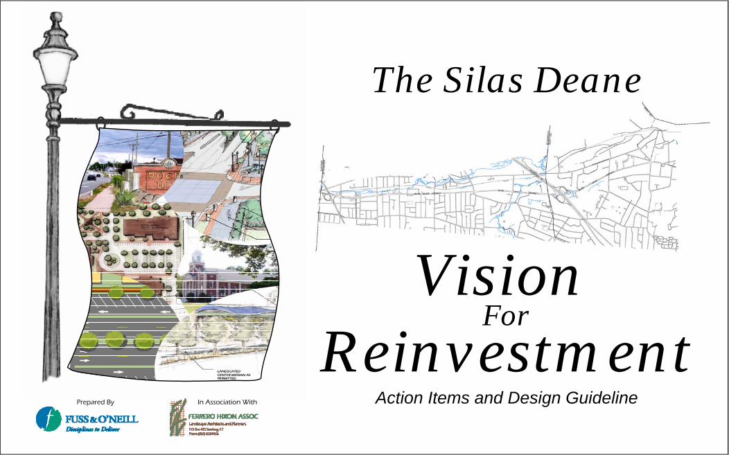
The Silas Deane
Vision For
ReinvestmentAction Items and Design Guideline

In Association With The Silas Deane Action Items and Design Guideline
Wethersfield & Rocky Hill, Connecticut Date : April, 2006
Prepared By
Scale : NTS
TABLE OF CONTENTS
Acknowledgements……………………………….Introduction……………………………………….Land Use……………………………………….
Opportunities and ConstraintsRecommendationsDesign Guideline
Transportation………………………………Opportunities and ConstraintsRecommendationsDesign Guideline
Streetscape…………………………………Opportunities and ConstraintsRecommendationsDesign Guideline
Architecture………………………………Opportunities and ConstraintsRecommendationsDesign Guideline
Reinvestment Sites………………………Town Centers……………………………Action Items…………………………..
P.1
In Association With The Silas Deane Action Items and Design Guideline
Wethersfield & Rocky Hill, Connecticut Date : April, 2006
Prepared By
Scale : NTS
Acknowledgements
SILAS DEANE ADVISORY COMMITTEE
Rocky HillChairman Larry deBearCouncilman Rocco SanzoCouncilwoman Barbara SurwiloDr. Ann Flandermeyer -Economic Development Commission John Harvey - Rocky Hill ChamberDavid Schweitzer P.E –HNTB (Silas Deane Business)Melroy D’Costa -Hampton Inn (Silas Deane Business)Rob St. John - F.X. Messina (Silas Deane Business)
Mayor Anthony LaRosaEx –Officio/Town Manager Barbara Gilbert Staff –Jeanne Webb Chavez – Economic Development CoordinatorJames Sollmi, P.E. – Town Engineer
CONSULTING TEAMFuss & O’Neill, Inc. – Prime ConsultantFerrero Hixon AssociatesRKG AssociatesJames Vance and AssociatesPlanimetricsMoser Pilon Nelson
WethersfieldBetty Rosania – Economic Development and Improvement CommissionDave Edwards – Planning and Zoning CommissionCarmela Moore – Chamber of CommerceLeonardo Gugliotti – Silas Deane Business John Lepper – Resident and Tree WardenSteve Foote – ResidentBernadine Franco – Resident
Mayor Russ MorinEx –Officio/Town Manager Bonnie Therrien Staff –Peter Gillespie – Economic Development DirectorMike Turner, P.E. – Town Engineer
Collaboration between the neighboring Towns of Wethersfield and Rocky Hill in the area of economic development has presented a unique opportunity to bring positive change in the Silas Deane corridor. The contributions of the Silas Deane Advisory Committee, Public Officials, and Town Staff through the public involvement process have yielded a compelling vision for reinvestment in each town.
P.2

In Association With The Silas Deane Action Items and Design Guideline
Wethersfield & Rocky Hill, Connecticut Date : April, 2006
Prepared By
Scale : NTS
INTRODUCTIONWethersfield and Rocky Hill public officials, staff, business owners, and volunteer residents have worked diligently in the past 24 months to define a vision for the Silas Deane Highway in order to promote economic revitalization, create a sense of place, improve aesthetics, and restore a connection to the history of the region. Today each community stands ready for this Implementation Phase.
The Fuss & O’Neill / Ferrero Hixon Associates team was selected by the Silas Deane Advisory Committee (SDAC) to build upon the significant work done in the past, add details to the plan, and begin implementing improvements to the Silas Deane Highway. This project presents a unique challenge of dual municipalities, state owned roadway and a diversity of required disciplines including transportation engineering, land use planning, streetscape, market analysis, and architecture.
Our team has conducted field work, visual analysis, data collection and preparation of base mapping. We have attended field walks with members of each community and held numerous public involvement and work shop meetings in each town, including an evaluation of opportunities and constraints and a full market study prepared and presented to the SDAC. The project has included the preliminary coordination of our transportation engineering, and access management ideas with the Connecticut Department of Transportation in order to gather early input into the process for potential modifications within the State right of way.
The information provided herein summarizes the vision for The Silas Deane and necessary action items to achieve the vision. Design Guidelines are provided to allow the Towns to manage the process of change in the corridor. The document is broken into the sections of Land Use, Transportation, Streetscape, Architecture, and Zoning. Each section includes a discussion of existing conditions opportunities and constraints, followed by recommendations and design guidelines. This document is intended to be used by both towns as a guideline to design and review of public and private development and infrastructure projects.
The Silas Deane Highway (Route 99) in the towns of Wethersfield and Rocky Hill is a 4 lane roadway, classified by the Connecticut Department of Transportation (ConnDOT) as an urban minor arterial. The project limits extend approximately 5 miles from the intersection at Route 160 (Elm Street) at the south end through the Interstate 91 (I-91) interchange and continuing north to the Routes 5/15 overpass. The land along the Silas Deane Highway is heavily developed with a mix of retail, office, and residential developments in both towns. Traffic congestion is typically not a major issue along the highway in either town, with a few exceptions. The 4 lane configuration typically provides excess capacity for the existing traffic volumes, and travel speeds are correspondingly high. In Wethersfield, the Silas Deane Highway provides a five lane cross-section, allowing for left turn lanes at major driveways and all signalized intersections.
The following table summarizes opportunities and constraints for the corridor. Opportunities and constraints are defined as follows:
Opportunities to enhance the corridor, and promote reinvestment by private property owners
Constraints which limit or prohibit physical improvement and economic revitalization
Summary of Opportunities and Constraints
Opportunities Constraints Transportation Wide Right of Way High vehicular speeds Available capacity to support traffic growth Expansive pavement width Interstate visibility State owned roadway, ConnDOT
coordination Access management Many curb cuts Transit potential: railroad corridor Bicycle limitations Transit service : Bus Pedestrian safety at intersections Sidewalk system breaks Streetscape Existing trees in some places Lack of hierarchy Potential gateway areas Mono-aesthetic Bridges (portals) Lack of nodes and landmarks Generous tree belts Inconsistent theme Front yard parking Town signage location/ aesthetics No tree belts or buffers to parking Land Use Available parcels Many underutilized properties / buildings Regional location Individual small parcels / ownership Mixed uses Many small property owners, small parcels Connections to historic Wethersfield Property depth (very shallow) Nodal development Regulatory constraints Established shopping centers and office uses Wetlands Strong residential component Overhead high voltage power corridor Solid government centers Architectural Brick treatments Many small, diverse style, older buildings Significant buildings Portals Brand / Image River commonality Silas Deane controversial as a person? “Portal Concept” Strip mall corridor perception
P.3
INTRODUCTION

In Association With The Silas Deane Action Items and Design Guideline
Wethersfield & Rocky Hill, Connecticut Date : April, 2006
Prepared By
Scale : NTS
LAND USEConstraints:
•Under utilized land and buildings: There are many properties and developments along the corridor, which are currently under utilized with respect to the maximization of appropriate land uses in the corridor as a whole. Possible reasons include individual property ownership and development patterns, there by substantially reducing overall property and land efficiency, market factors, and current regulatory and environmental limitations.
•Lack of property consolidation and cross parking connections, etc.: As much of the corridor is in individual property ownership, this may represent one of the greatest challenges to positive redevelopment, as much of this redevelopment may be contingent on property owner cooperation and agreement. This challenge will be most prevalent in attempts to consolidate smaller parcels and enhance access management. In general, the greatest challenge will be amongst the smaller parcels.
•Current regulatory guidelines: Current regulatory guidelines appear to inhibit the potential for new development patterns as outlined by the SDHAC. The components of corridor scale, development of recognizable nodes, streetscape hierarchies and development incentives may be attributed to zoning issues such as maximum allowable coverage and FAR, building height limitations, property line setbacks, and to some extent parking regulations. Modifications to these existing regulations may support a more positive climate for change along the corridor.
•Property depth: There are a number of small sized properties along the corridor in both towns. The depth of many of these properties is further restricted by adjacent environmental systems or single-family residential neighborhoods. This may prove to be a deterrent to consolidation of multiple properties for a single use, particularly with respect to property depth.
•Market constraints: Although the market study prepared as part of this plan indicates regional draw along the interchange areas, the remainder of the commercial uses are, and will be shaped by more local supply and demand. This may influence the market ability of property consolidation and larger mix-used developments in areas other than the highway interchanges.
Opportunities:
· Available parcels: There are a number of available and developable parcels along the corridor and identified by the town.
· Mixed Uses: In general existing corridor land uses exhibit an array of mixed uses from multi family housing to commercial, industrial and hospitality uses. There is an opportunity to continue to foster the development of mixed uses particularly in market-defined gaps.
· Connections to historic Wethersfield: As historic Wethersfield is an important element in the cultural aspects of Wethersfield its location and proximity to the Silas Deane Highway should be promoted and exploited.
•Nodal development: There exists an opportunity to develop a hierarchy of patterns along the corridor with the creation and enhancement of specific nodes. These development nodes would primarily be located at each of the major interchanges as well as each of the town centers of Wethersfield and Rocky Hill. The nodal development opportunity is enhanced in Wethersfield by the utilization expansion and connections of Beaver Brook Road with the Silas Deane Highway augmenting existing traditional town center land uses of government, business, education and religion. In Rocky Hill this nodal development may be enhanced through a more direct connection of the town hall complex to the Silas Dean Highway interchange in that area. Rocky Hill’s town center may also exploit some of these traditional town center uses.
•Established land uses: In certain portions of the corridor, particularly at the I 91 highway interchange there exists many well established land uses including hospitality, commercial, retail, office and service. This interchange area currently represents the most desirable and marketable portion of the highway. As such an opportunity exists to build and expand on existing and future complimentary uses in these areas and elsewhere on the corridor. The development of appropriate incentives, aesthetics and partial consolidation options will ,enhance this areas viability as a regional destination as well as provide a catalyst for enhancements to properties on the remainder of the corridor.
•Strong residential component: There are several stable residential neighborhoods and communities along or adjacent to the Silas Deane Highway in both Rocky Hill and Wethersfield. Wethersfield’s neighborhoods primarily exist single-family neighborhoods while Rocky Hill’s are primarily multi-family. The proximity of residential neighborhoods to the Silas Deane Highway lends to the true mixed nature of the corridor. Opportunities for creating transitional, higher density residential housing exist in both towns. These higher density-housing areas will help provide impetus for further neighborhood commercial expansion and provide an appropriate transition from lower density residential neighborhoods to the commercial corridor. The specific target market for potential residential communities in each of the towns will vary.
•Solid government centers: The governmental land uses in both towns represent strong opportunities for the development of solid identifiable nodes along the corridor. The proximity of these areas in relation to the Silas Deane should be strengthened and exploited. Complementary land uses, attractive mixed use out door activity areas and direct vehicular and pedestrian opportunities exist. The coincidental location of these areas begins to create the desired hierarchy of uses and nodes.
•Beaver Brook Open Space: This natural area provided limitless opportunities to create direct pedestrian and recreational connections to the corridor from the adjacent neighborhoods in Wethersfield. Additional studies may focus on the physical feasibility of developing these areas into a town wide recreational amenity consistent with the findings of the Beaver Brook Open Space study prepared in the 1960’s..
P.4
LAND USE

In Association With The Silas Deane Action Items and Design Guideline
Wethersfield & Rocky Hill, Connecticut Date : April, 2006
Prepared By
Scale : NTS
ROADWAY CONNECTORS CONNECT GOVERNMENT CENTER AREA WITH
HIGHWAY USES
GATEWAY GREEN
TOWN CENTER DEVELOPMENT INCLUDING ROUNDABOUT, NEW
CONNECTING ROADS, TOWN GREEN, ETC
FUTURE VILLAGE IMPROVEMENTS TO FERRY
ACCESS
FUTURE LOT / BUILDING RECONFIGURATION PERPENDICULAR
TO SILAS DEANE
CONTINUE BIKE / PEDESTRIAN CONNECTION TO FERRY AREA
IMPLEMENT BEAVER BROOK OPEN SPACE PLAN AND NEIGHBORHOOD CONNECTIONS- BIKE PATH
REALIGN HEWITT STFUTURE MULTI-FAMILY HOUSING TRANSITION ZONE
GATEWAY PARK-PRESERVE OPEN LAWN AND VIEWS TO STEEPLE
PRESERVE RESIDENTIAL CHARACTER
TOWN CENTER DEVELOPMENT INCLUDING “TOWN GREEN”, BEAVER BROOK ROAD EXTENSION, ETC
PROMOTE CONTINUOUS REAR ACCESS ROAD AND BIKE PATH ALONG RAILROAD RIGHT OF WAY. POTENTIAL COMMERCIAL FRONTAGE AND LOT ACCESSES. PROVIDE
MULTIPLE ACCESS POINTS TO SILAS DEANE.
“TOWN GREEN”
6 5
3
2
1
4
PROVIDE SIGNAGE / DIRECT CONNECTION TO “HERITAGE WAY BIKE PATH”
PROPOSED TOWN GREEN
P.5
LAND USE

In Association With The Silas Deane Action Items and Design Guideline
Wethersfield & Rocky Hill, Connecticut Date : April, 2006
Prepared By
Scale : NTS
TRANSPORTATIONConstraints
•Speed: Vehicle speeds are typically 10 to 15 mph higher than the posted speed limits. These speeds are encouraged during off peak periods when traffic is light and the freedom of many lanes of pavement and open road result in higher speeds. High vehicular speeds contribute to many other challenges to businesses along the Silas Deane. Access to/from unsignalized driveways can be very difficult, particularly making a left turn across multiple lanes of traffic traveling at 50 mph.
•Pavement width: The Silas Deane is four to five lanes wide in both towns with turning lanes at major intersections and traffic signals. Although the number of lanes allows traffic to move very well, it also encourages higher speeds during off peak periods. The pavement width also presents a constraint in that it’s difficult to have a “sense of community”, or pedestrian scale to such a wide roadway corridor.
•State owned road: The Silas Deane Highway is designated as State Route 99 and the right of way is owned by the Connecticut Department of Transportation. Any proposed improvements within the right of way lines will necessitate review and approval by ConnDOT through the encroachment permit process.
•Curb cuts: The land along the Silas Deane Highway has been heavily developed over the years, and the result is many driveways scattered along both sides of the roadway. There are numerous conflicts for vehicles turning in and out of the many drives. Accident data provided by ConnDOT indicate that approximately 50 percent of the accidents on the Silas Deane Highway take place at private driveways.
•Bicycle limitations: The roadway corridor provides a typical two foot wide shoulder for bicycles. This narrow shoulder is adjacent to multiple travel lanes with high speed traffic and is therefore very uncomfortable for bicyclist use. The Silas Deane is not a designated Bike Route by the Connecticut Department of Transportation.
•Pedestrian safety: High speeds, and expansive pavement width contribute to an unsafe condition for pedestrian crossings the sixty foot wide Silas Deane Highway. Sidewalk ramps are missing, or outdated at many locations resulting in a difficult maneuver for wheel chair users.
•Sidewalk system breaks: The sidewalk system has many gaps in each town making it difficult for pedestrians who live or work in the corridor to safely walk to and from local businesses, restaurants, and convenience stores.
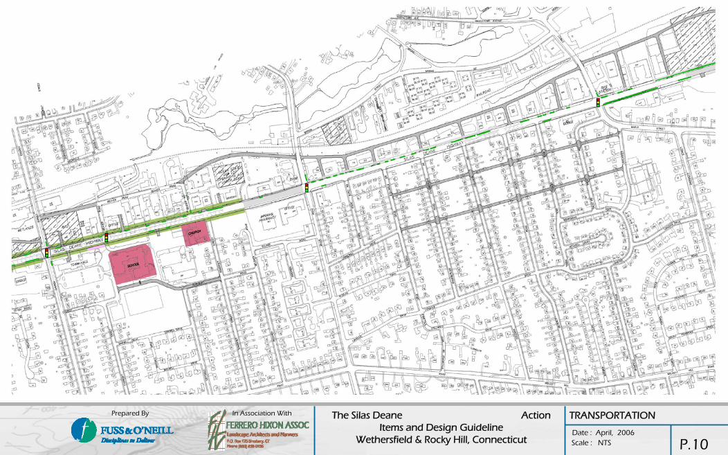
•Intersections: Several problematic intersections were noted during our field work. See Opportunities and constraints report prepared under separate cover for detailed analysis:
Opportunities
•Wide right of way: Typical right of way width ranges from 85 feet to 150 feet wide with the average section being approximately 100 feet wide. Pavement width varies from 55 to 80 feet wide within the right of way. The excess right of way outside the pavement supports the presence of sidewalk, guide rail, culvert bridges and other amenities.
•Capacity reducing modifications could potentially be made to the Silas Deane Highway without adversely affecting traffic operations. Possible modifications include angled on street parking, lane reductions, lane width reductions, landscaped medians, or two-way center left turn lanes. These modifications would help to reduce the average speed of vehicles traveling on the roadway, increasing the safety for all road users.
•“Road diet” is a buzz word and a relatively new idea in roadway enhancement. The concept is to reduce the number of lanes on roadways where excess capacity exists. The resulting benefits are many, including reduced speed, reduction in the number and severity of accidents, increased access for pedestrians and bicyclists, and increased property value.A road diet typically involves reducing the capacity of the roadway by way of narrowing or reducing lanes, along with installing new roadway features such as center turning lanes, landscaped medians, or bicycle lanes. Road diets are most often applied to roads with ADT of 12,000 to 18,000, but may be applicable on roads with volumes as high as 25,000 vehicles per day.
•Installation of a center two-way left turn lane in the place of the existing alternating exclusive left turn lanes on the roadway segments between signalized intersections would improve access to businesses that currently do not have left turn lanes. This option also improves the safety along the corridor.
•Designation of a landscaped median would beautify the Silas Deane Highway, while improving traffic safety. Restricting left turn movements from unsignalized driveways will reduce the number of accidents, but may negatively impact local businesses. Specific stake holder discussions would be required prior to the initiation of final plans.
•The installation of sidewalks and crosswalks where they are missing.
•ConnDOT Coordination: Any modifications proposed for the Silas Deane Highway must first be reviewed and approved by ConnDOT, in accordance with their regulations for state highways. Meetings were held with ConnDOT in order to determine issues with the various concepts developed by the design team.
A roundabout can be considered at the Five Corners intersection in Rocky Hill and for locations where ADT on the Silas Deane Highway is less than 20,000 vehicles.
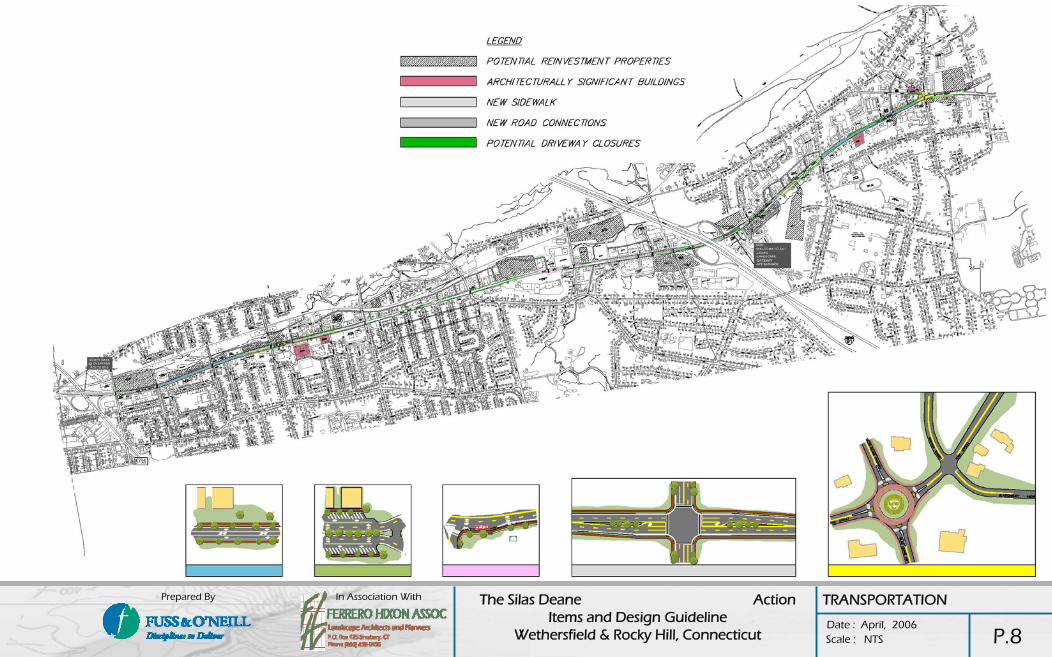
Available Capacity: The number of lanes provide an ability to support additional development and associated increases in traffic volumes. Most intersections can accommodate traffic increases, and right of way is available to support traffic improvements to several intersections where traffic congestion exists. Potential improvements at several intersections might be considered and are illustrated on the following pages..
Access Management: The goal of access management is to reduce the number of conflict points along a roadway and to manage the spacing of conflict points to ensure safe and efficient travel.. There are several measures that can be considered in order to provide better access management along a roadway. These recommendations include: parking lots with multiple entry and exit points, wide curb cuts can be narrowed, access to businesses located on an intersection can be limited to the minor street, where conflicting traffic volumes are lower, provide internal connector roads to the rear of adjacent sites. We have identified numerous opportunities for curb cut reduction and internal driveway connections.
Transit – Railroad: Active railroad tracks run parallel to the Silas Deane Highway within the project limits. This rail corridor is a consideration for potential long term transit connectors to Hartford. The railroad right of way may be considered for other uses such as a multi use path which could provide a connection to the Beaver Brook Linear park, historic Wethersfield, the Rocky Hill Ferry, etc. Alternatively, the railroad corridor could be used in some Wethersfield locations to provide rear internal connections between sites in order to reduce curb cuts and promote access management.
Transit – Bus Service: Opportunities exist to improve the bus service within the corridor through additional stop locations at key reinvestment properties and enhancement of existing bus stop amenities.
P.6
TRANSPORTATION

In Association With The Silas Deane Action Items and Design Guideline
Wethersfield & Rocky Hill, Connecticut Date : April, 2006
Prepared By
Scale : NTS
TRANSPORTATION GUIDELINES
The guiding principles for implementation of transportation improvements can be summarized in the following corridor goals:
Reduce speed without reducing capacity of the roads and intersections:
Reduce pavement width, introduce center planted islands, and reduce geometry (radii, etc) to send a message to the driver that 35mph is the right speed. One example is the removal of the high speed ramps to and from I-91.
Create a pedestrian friendly environment, a place where people want to live, work, and recreate: Upgrade sidewalk ramps, and push buttons to create a corridor that is friendly to the disabled and elderly communities.
Manage access to the Silas Deane:
Combine curb cuts and create rear connector drives, and internal parking lot connections between sites. Install two way center left turn lanes where recommended. Create on street parking opportunities to “bring the street to the building”, thus reducing setbacks. As site development projects are brought to the Town, Town staff should stress the incorporation of shared drives, and internal connections and should also preserve the land for a rear connector drive in an easement.
New traffic signals could be proposed at major shared driveways as an incentive for property owners to combine access. Other access management incentives could include density, shared parking (reduction of required parking), or signage increases.
Improve transit service:
Provide bus pull offs as recommended. Change the CT Transit route to follow the Silas Deane in Rocky Hill. Architectural bus shelters can be provided to fit with the streetscape of the corridor.
Long term action will be to work with the Capitol Region Council of Governments to initiate passenger service on the Valley Rail Line railroad corridor to create a commuter route to Hartford, connection to Adriaen’s Landing, and opportunities for the proposed Housing element in the Silas Deane corridor.
Transit oriented development would be a natural benefit of additional rail stations in Wethersfield and Silas Deane.
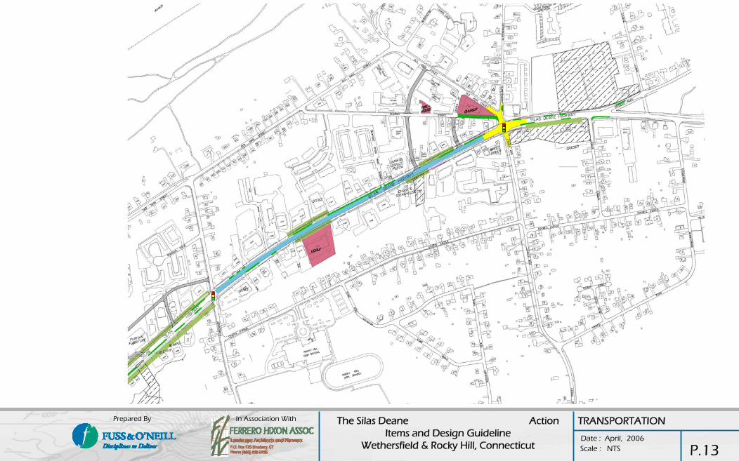
Roundabout:The intersection of Silas Deane at Route 160 has been depicted as a roundabout intersection as part of our recommendations. Although we feel confident that this is the best option to meet the Town’s objectives in the Town Center, we also understand that the proposal has evoked strong opinions from the public.
We suggest that the Town undertake an effort to conduct preliminary engineering and evaluation of alternatives specific to this intersection. Other options including traffic signal will work, but will not allow for the significant reduction of travel speeds, safety enhancement, and aesthetic benefits of the roundabout. We feel that the Town should take the time to fully understand the pros and cons of each option before making this important decision.
Funding:Preliminary conversations with ConnDOT have indicated that several projects would be eligible for State and Federal funding. The improvements concept for removal of the high speed I-91 ramps was viewed favorably by ConnDOT as an opportunity for a safety enhancement.
The Towns should continue to collaborate on packaging transportation projects for funding through the DECD STEAP Grants, and ConnDOT Enhancement, and Safety Improvement Programs.
P.7
TRANSPORTATION
In Association With The Silas Deane Action Items and Design Guideline
Wethersfield & Rocky Hill, Connecticut Date : April, 2006
Prepared By
Scale : NTS P.8
TRANSPORTATION
In Association With The Silas Deane Action Items and Design Guideline
Wethersfield & Rocky Hill, Connecticut Date : April, 2006
Prepared By
Scale : NTS P.9
TRANSPORTATION
In Association With The Silas Deane Action Items and Design Guideline
Wethersfield & Rocky Hill, Connecticut Date : April, 2006
Prepared By
Scale : NTS P.10
TRANSPORTATION

In Association With The Silas Deane Action Items and Design Guideline
Wethersfield & Rocky Hill, Connecticut Date : April, 2006
Prepared By
Scale : NTS
TRANSPORTATION
P.11

In Association With The Silas Deane Action Items and Design Guideline
Wethersfield & Rocky Hill, Connecticut Date : April, 2006
Prepared By
Scale : NTS
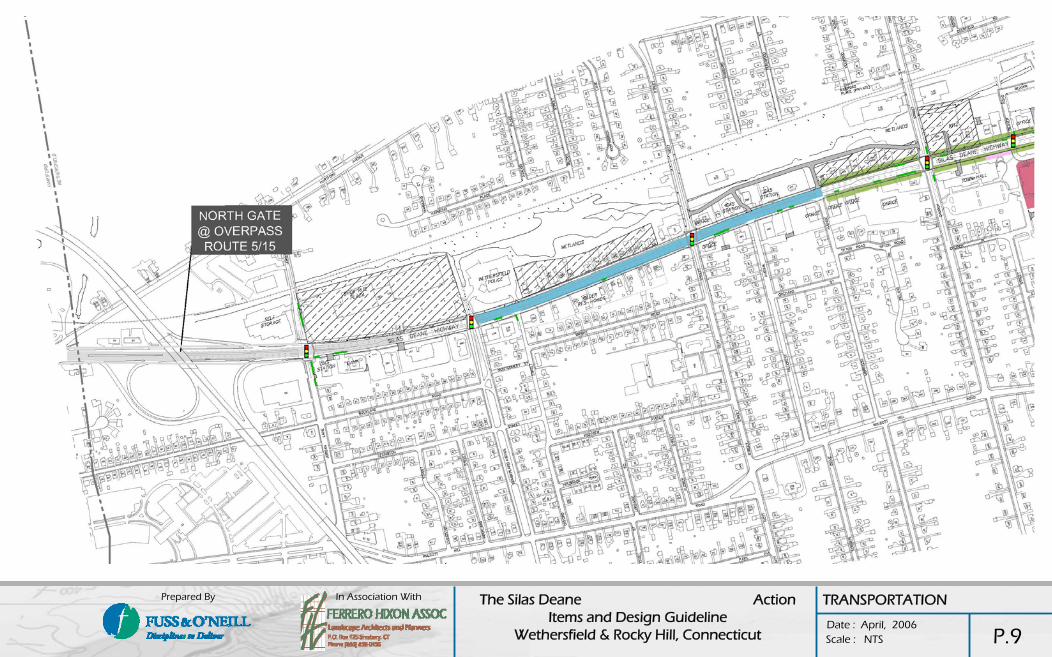
REMOVE RAMP
REMOVE RAMP
TRANSPORTATION
P.12
In Association With The Silas Deane Action Items and Design Guideline
Wethersfield & Rocky Hill, Connecticut Date : April, 2006
Prepared By
Scale : NTS
TRANSPORTATION
P.13

In Association With The Silas Deane Action Items and Design Guideline
Wethersfield & Rocky Hill, Connecticut Date : April, 2006
Prepared By
Scale : NTS
BRAND / IMAGEThe development of a meaningful “brand” and image” of a space such as the Silas Deane requires insight into it’s users, it’s history, and it’s future vision. From the combination of these elements, in conjunction with the existing positive images, the idea of an image, and subsequently a brand, emerges.
Recommendations of the organization of the image of the space includes the presentation of a common theme for the corridor in both towns, while highlighting, or personalizing elements unique to each town, or space. In addition, the concept of the Portals, and that of the promotion of a graduated hierarchy of Nodal Development has led the design team to the following thoughts on branding, image, and the utilization thereof along the corridor.
SOURCES OF POSSIBLE IMAGE DEVELOPMENT COMMON TO BOTH TOWNS.
The Connecticut River: The river has played a crucial role in the development and settlement of each town from the fertile farmlands in Wethersfield to the boat building and ferry in Rocky Hill. Building on the concept of the corridor as a series of Portals and a hierarchy of Node and activity centers, the entire space may be viewed as a “contemporary river of commerce”. Node areas representing harbors along the river where movement slows and activity is concentrated versus the in between movement areas. Details could be developed in these area corresponding to the agrarian connections to the river in Wethersfield, and the Boat building connections to the river in Rocky Hill. The sketches presented illustrate a couple of many possible examples of how this theme may translate to physical design. Final design of these elements would require building design consensus among interested parties and will be contingent on technical review by the towns and the DOT. Streetscape elements along the corridor and in the nodes may also reflect this design motif.
In addition to this treatment of Portals and nodes, other opportunities may include:
All signage excluding gateways and portals and including way finding, street signs, business signage both on street and façade mounted, awnings, Banners, traffic signage (if possible), etc. The idea would be to exhibit through design a colorful motif which exhibits flow, and movement.
The full development of the Beaver Brook pedestrian / open space corridor and the future utilization of the Rail Road ROW as pedestrian connectors may be common to both towns and developed utilizing detailing consistent with this theme.
Potential water features located within each of the two town center nodes and near the interchange gateway / portal areas
Light standards: Modern but picking up on selected period shapes and forms
Walk ways: In the early 20th century the Bolton Bluestone Company supplied this area with materials which were used for sidewalk construction. The use of bluestone or a bluestone like material and brick would be complementary, and provide both image linkages and the look of permanence and quality.
BRICK SIGN FACE PICKS UP ON BRICK USE IN TOWN CENTER AND
TOWN HALL COMPLEX
OFF WHITE PRECAST ARCHITECTURAL
CAPPING
LOGO INSET
BRONZE OR BRASS LETTERING ON INSET
BRICK PANEL
BASALT WALL BASE SYMBOLIC OF THE TOWN’S
NAMESAKE
PRECAST OFF WHITE CONCRETE CYLINDERS
SYMBOLIZING HISTORIC DOCK/WHARF RIVER USE
AT THE FERRY
BRIDGE “RIVER ATTACHMENT”
NEW CONNECTING SIDEWALK BOTH SIDES
WARF / PIER BRIDE ABUTMENT FEATURES
NEW COBRA STREET LIGHTS
ABUTMENT BUFFERS
LANDSCAPE IN “CROP ROWS”
TOWN FLAG AND POLE. ONE TOWN ON EACH SIDE OF BRIDGE
LANDSCAPED CENTER MEDIAN AS PERMITTED
SILAS DEANE LOGO AND OR TAG LINE
NUMEROUS SMALL REFLECTIVE PANELS UNDER BRIDGE DECK.. PROVIDE
LIGHTING TO CREATE A WATER “GLITTER” EFFECT
BRIGHT GRAPHICS IN BRIDGE PANEL INSETS. PROVIDE UP LIGHTING
TYPICAL WAY FINDING SIGNAGE TYPICAL GATEWAY SIGNAGE (ROCKY HILL)
TYPICAL PORTAL / BRIDGE ENHANCEMENT
BRAND / IMAGE
P.14

In Association With The Silas Deane Action Items and Design Guideline
Wethersfield & Rocky Hill, Connecticut Date : April, 2006
Prepared By
Scale : NTS
STREETSCAPEConstraints:
•Corridor scale / special hierarchy: The majority of the Silas Deane is comprised of a massive road cross section abutting one and two story structures with generous property line setbacks on both sides of the road. These proportions, combined with unbuffered front yard parking areas create a harsh non-pedestrian scale where the automobile and overhead utilities are clearly the dominant corridor elements.
•No consistency to theme / motif: With the exception of the automobile and overhead utilities, there is no substantial common repeating thematic elements which would serve to tie the corridor together visually.
•Lack of Nodes and Landmarks: Nodes and landmarks, particularly in a linear system, help establish variety, natural way finding and recognition, identity and hierarchy. With the exception of the church near the Wethersfield Town Hall, and small hand full of other buildings, the highway appears devoid of anything resembling a nodal center or architecturally significant landmark.
•Visual clutter: Vertical elements in the landscape (natural or man made) have the most substantial visual impact on any given space. They define space, character, scale and proportion. With the exception of overhead utilities and automobiles, the vertical elements along the highway are inconsistent, random and chaotic and include such elements as business and traffic signage, building facades and setbacks, front yard parking or amenities, etc.
Opportunities:
•Limited Existing Street Trees: There exists in a few isolated areas along the corridor including good examples of commercial streetscaping as well as a few older developments with mature trees close to the property line . It is apparent that the larger newer developments have been urged to provide street trees along there respected frontages. As parking areas visible from the corridor, there are also some positive attempts at buffering these areas such as utilizing mixed landscape beds or hedges.
•Clearly Defined Gateway Areas: The two highway interchanges represent clearly defined and logical locations for town wide gateway signage as well as acting as “portals” to the corridor itself. Celebration of the corridor itself as well as entrance to the respective towns should be enhanced in these existing areas.
•Portals ( Bridges): Tall Vertical elements in the landscape will provide a sense of scale in the area. Currently the only vertical features providing scale are a few isolated multi-story buildings, visually dominant overhead utilities and very limited mature street trees.
•Bridge Structures and abutments: An opportunity exists to enhance bridge structures and abutments in a way that provides a sense of entry and exit into the space, at the two ends and celebrates the arrival and departure from Silas Deane.
•Right of Way/ Tree Belts: The Silas Deane Highway enjoys every generous state highway right of way. The rearrangement of elements within this right of way should seek to maximize the efficiency of land available for streetscaping purposes. Traffic studies should investigate the reduction of corridor lanes where appropriated and the distribution of excess land shared either in wider tree belts or center medians.
STREETSCAPE PLAN
There are many components to the streetscape plan. These components and designs seek to enhance the safety, pedestrian circulation, aesthetics and the scale of the corridor as a whole. Many components may be implemented in the short term however numerous items will require private property cooperation, CT.DOT review and or property consolidation and reinvestment in order to be realized. Long-term implementation should be coordinated and realized as new opportunities are presented. Therefore, this plan is categorized into phases and includes elements that may be implemented immediately (short term implementation) and elements, the implementation of which would only coalesce upon the appropriate development conditions listed above, (long term implementation).
Although the elements proposed along the corridor vary by section, the long term short term implementation concept is the same for all areas. The primary elements of the plan are described below and illustrated on sheets entitled “Typical Cross Sections”:
Short-term improvements:
Landscaping: Landscape (planting) will be limited to the roadway edges. A planting palette has been proposed. Short-term landscape should be coordinated with longer-term goals.
Parking lot buffers: Every effort should be made to screen or remove existing parking lots along the highway. Low hedges and fences are proposed depending on the section of the corridor.
Signage: Gateway and Way finding signage as well as the development of “the portals” and new street signs may be implemented immediately. Similarly, coordination with CTDOT to reduce traffic signage should be studied in the short term.
Lighting: Based on safety considerations, and the width of the travel lanes, it may be anticipated that ornamental lighting alone will not provide the light necessary wash. Ornamental lighting, while substantially improving the aesthetic quality of the corridor, will be primarily ornamental; it’s greatest functional benefit being illumination of the pedestrian sidewalk system. It should be noted that the maintenance of ornamental fixtures might be require by the municipality. Replacing existing cobra lighting with a more contemporary fixture should be considered.
Bus Stop Enhancements: New and aesthetically coordinated bus stop and shelter areas should be implemented immediately as they will provide a highly visible vertical enhancement to the corridor.
Walkways: Priority should be geared toward missing sections, including development of pedestrian paths under the highway overpasses. Sidewalk development should conform to types and locations illustrated herein.
Crosswalks at intersections: Painted and patterned cross walks may be installed immediately.
Portal enhancements: A primary component of this study is aesthetic and thematic enhancements to the two highway underpass bridges. These improvements will have immediate and significant aesthetic benefits to the overall image of the corridor.
Long Term Improvements:
New / modified roadway configurations as illustrated in the transportation section
Parking lot connections and curb cut reductions (access management): These improvements will substantially enhance all aspects of the corridor. It is also expected to be the most difficult concept to implement corridor wide. As such, efforts should be made to implement these recommendations on a case-by-case basis, including the corresponding implementation of affected streetscape improvements.
Underground utilities: Overhead utilities along the corridor are the most visually intrusive element on the highway. Given the expense of relocating these utilities underground for the entire length, the towns should focus on acquiring the capital to bury utilities within the town center areas.
Center medians: This is also a significant visual and traffic calming improvement which will be contingent on required traffic engineering as well as curb cut reductions and consolidations, and should be developed on a case by case basis with particular emphasis on the town center areas.
Building setbacks: Only applies to reinvestment areas. The concept of building heights and setbacks is a long-term recommendation, which provides a hierarchy of horizontal and vertical scale to the corridor. The concept will also create visually distinct districts along the highway. In general, the regional commercial areas associated with the highway interchanges would include taller buildings set farther back into the lots with the informal landscaped front yards and streetscapes. Progression of building height generally remains the same, but building setbacks diminish greatly toward the centers. This long-term concept in the centers will promote urbanized pedestrian active centers while substantially calming existing traffic speeds and creating a distinctly different feel than the interchange areas.
STREETSCAPE
P.15

In Association With The Silas Deane Action Items and Design Guideline
Wethersfield & Rocky Hill, Connecticut Date : April, 2006
Prepared By
Scale : NTS
NOTES: •BUILDING SETBACKS IN NS-1 WETHERSFIELD MAY BE ADJUSTED DUE TO LIMITED LOT DEPTH
•PARKING BETWEEN BUILDING LINES AND FRONT LINE SHALL BE DISCOURAGED IN ALL CORRIDOR SECTIONS
•CENTER MEDIANS SHALL BE IMPLEMENTED WHEREVER ACCESS MANAGEMENT AND TURNING LANES ALLOW
•BUS STOPS AT ALL INTERSECTIONS TO RECEIVE BUS SHELTER AREA (SEE SKETCHES)•PROVIDE CENTER MEDIANS ON ALL EW INTERSECTION ROADWAYS WHERE POSSIBLE
•WAYFINDING SIGNAGE PLACEMENT TO BE +/- 200’ FROM INTERSECTION, ONE SIGN NORTH & ONE SOUTH OF INTERSECTION
•SEE PLANT PALETTE FOR CORRIDOR AND INTERSECTION LANDSCAPING GUIDELINES
INSTRUCTIONS TO THE USER:•BASED ON THE ANALYSIS AND CONCEPTS OF CORRIDOR REHABILITATION CONTAINED HEREIN, THE FOLLOWING CHARTS ARE INTENDED AS A GUIDE FOR FUTURE PRIVATE AND PUBLIC DEVELOPMENT PROJECTS. THE CORRIDOR IS DIVIDED INTO BOTH NORTH / SOUTH SECTIONS LABELED AS ( NS #) AND EAST / WEST SECTIONS LABELED AS ( EW #). SIMILARLY, EACH MAJOR INTERSECTION IS IDENTIFIED AND LABELED ( I #). THE PROPOSED ATTRIBUTES RELATING TO EACH CORRIDOR SECTION AND INTERSECTION ARE EACH KEYED TO SPECIFIC DESIGN RECOMMENDATIONS WHICH ARE CONTAINED ON THE FOLLOWING PAGES. THE EXACT BOUNDARIES OF EACH DESIGNATION WILL BE DETERMINED BY THE LAND USE AGENCIES FOR EACH TOWN IN ORDER TO PROVIDE SOME DEVELOPMENT FLEXIBILITY.•PROPOSED BUS STOP AREAS, WAY FINDING SIGNAGE, AND GATEWAY SIGNAGE LOCATIONS ARE INTENDED AS APPROXIMATE AND WILL BE DETERMINED THROUGH SITE SPECIFIC DESIGN WITHIN THE DESIGNATED AREAS.
CORRIDORS Maximum / Minimum Minimum
NS-1
NS-2
NS-3
EW-1
EW-2
EW-3 W-3 L-1 & L-2 PB-3 0 10’ max 2 - 4 Maximum
Walks Lighting Parking Buffers (Short Term)
Tree Belts CommentsFurniture/ Street AmenitiesBuilding StoriesBuilding Setbacks
W-1
W-2
W-3
W-1
1 - +/-8
W-2
35’ min+/- 15’PB-1L-1
L-1 10’ min / 20’ max
L-1 & L-2
7 -10’
L-1
PB-2
PB-3
PB-1
4 - 7’
L-1 PB-2
4’
0 – 4’
10’ max
20’ min
2 - 3
2 - 4
1 - 4
2 - 4
None – Min.
Minimum
Maximum
None - Minimum
Minimum
Tallest buildings at interchanges- Tree belt widths may vary at Rt. 15 interchange area due to limited parcel size
Banners on all 0-1 lights
10’ min / 20’ max
Other
W-2
W-3
W-2
W-1
W-2
W-3
W-3
W-2
W-1
W-1
Walks (See Walk
Details)
Minimum-Maximum2-40’-20'25’NOPB-3L-2CW-2I-10 DIVIDEND RD
Maximum2-50’-10'60’YESPB-3L-2CW-3I-9 ELM ST
I-8 PARSONAGE ST
I-7 TOWN LINE RD
I-6 MAPLE AVE
I-5 WELLS RD
I-4 CHURCH ST
I-3 NOTT STREET
I-2 CUMBERLAND AVENUE
I-1 JORDAN LANE
INTERSECTIONS- (Uncolored Intersections Primarily Follow Intersection Guidelines)
CW-2
CW-1
CW-2
CW-3
CW-3
CW-3
CW-2
CW-1
Crosswalks (See Crosswalk
Details & Intersection Enlargement)
L-2
L-1
L-1
L-2
L-2
L-2
L-1
L-1
Lighting(See Cut Sheets)
PB-2
PB-1
PB-2
PB-3
PB-3
PB-2
PB-1
PB-1
Parking Buffers
NO
NO
NO
YES
YES
NO
NO
NO
On-Street Parking
60’
60’
60’
60’
25’
25’
25’
25’
Turning Radii
10’/15’
25' min.
10’/15’
0’/10’
0’/10'
10’/15’
10’/15’
25’ min
Building Setbacks
Max/Min
2-3
1-5
2-3
2-4
3-5
2-4
1-3
1-5
Building / Stories
Minimum
None-Minimum
None-Minimum
Minimum-Maximum
Maximum
Minimum-Maximum
Minimum
None-Minimum
Streetscape Furniture(See Cut Sheets)
Taller Buildings allowed near interchange
Connect to Heritage Bike Way
Gateway area include water
Comments
STREETSCAPE KEY MAP
P.16

In Association With The Silas Deane Action Items and Design Guideline
Wethersfield & Rocky Hill, Connecticut Date : April, 2006
Prepared By
Scale : NTS
EXISTING CONDITIONS
SHORT TERM
LONG TERM
NS-1 NS-2
EXISTING BUILDING
EXISTING BUILDING
EXISTING BUILDING 1-2 STORIES
EXISTING BUILDING
R.O
.W. (
TYP)
REGIONAL CORRIDOR AREAS - TALLER STRUCTURES, BROAD INFORMAL TREE BELTS AND FRONT YARDS, LARGE SETBACKS
EXISTING FRONT YARD PARKING
INFORMAL CORRIDOR LANDSCAPE- MIX OF STREET AND FLOWERING TREES, BROAD TREE BELTS
PRIVATE PROPERTY PARKING LOT BUFFERS & LANDSCAPE
OPTIONAL MEDIAN TREATMENT – INVESTIGATE CURB CUT CONSOLIDATION AND TURNING LANE ISSUES (SEE ENGINEERING DRAWINGS FOR LOCATIONS)
ORNAMENTAL OVERHEAD LIGHTS REPLACE DOT COBRA LIGHTS
PROPERTY LONG TERM REINVESTMENT STRUCTURES 1-8 STORIES (TYP)
FORMAL RYTHYM OF FLOWERING TREES IN FRONT
YARD – REQUIRES FRONT PROPERTY AGREEMENT
EXISTING BUILDING
EXISTING BUILDING
EXISTING BUILDING 1-2 STORIES
EXISTING BUILDING
R.O
.W. (
TYP)
TRANSITION AREAS - FORMALIZED STREETSCAPE, MODERATE SETBACKS
EXISTING FRONT YARD PARKING
PARKING LOT BUFFERS / PLANT MATERIAL
ORNAMENTAL LIGHT POLES ILLUMINATE PEDESTRIAN WALKWAYS
(BOTH SIDES)
PROPERTY LONG TERM REINVESTMENT STRUCTURES 2-3 STORIES
ORNAMENTAL OVERHEAD LIGHTS REPLACE DOT COBRA LIGHTS
MINIMUM SETBACK = 35’
BOTH SIDES WHERE FEASIBLE
MEDIAN TREATMENT W/ ORNAMENTAL LIGHTING AND DIRECTIONAL SIGNAGE– INVESTIGATE CURB CUT CONSOLIDATION AND TURNING LANE ISSUES
BLDG SETBACKS 10’ MIN- 20’ MAXPROMOTE PEDESTRIAN STREET FRONT ACCESS (BOTH SIDES)
TYPICAL CROSS SECTIONS
P.17
In Association With The Silas Deane Action Items and Design Guideline
Wethersfield & Rocky Hill, Connecticut Date : April, 2006
Prepared By
Scale : NTS
EXISTING CONDITIONS
SHORT TERM
LONG TERM
NS-3 ROCKY HILL NS-3 WETHERSFIELD
LANDSCAPE FRONT YARDS WITH INFORMAL TREE PLANTING, IF POSSIBLE, IN SHORT TERM
EXISTING BUILDING
EXISTING BUILDING R.
O.W
. (TY
P)
EXISTING OVERHEAD UTILITIES / COBRA LIGHTS
EXISTING FRONT YARD PARKING (TYP)
PARKING LOT BUFFERS
ORNAMENTAL OVERHEAD LIGHTS REPLACE DOT COBRA NEEDS
MINIMUM BUILDING SETBACK
PROVIDE FRONT DOOR ACCESS TO CORRIDOR FROM NEW RESIDENTIAL UNITS WITH FRONT YARD
LANDSCAPE AND OPTIONAL FENCING OR HEDGES
PROPERTY LONG TERM REINVESTMENT STRUCTURES
2-4 STORIESOUTSIDE OF CENTERS
3-5 STORIES IN CENTER AREAS
10’ MAXIMUM BUILDING SETBACK – PROMOTE PEDESTRIAN ACTIVITY AT STREET LEVEL INTEGRATED WITH THE WALK SYSTEM – COORDINATE FURNITURE
& BUILDING SIGNAGE
R.O
.W. (
TYP)
MINIMUM BUILDING SETBACK
LANDSCAPE FRONT YARDS WITH INFORMAL TREE PLANTING, IF
POSSIBLE, IN SHORT TERM
EXISTING BUILDING
EXISTING BUILDING
EXISTING BUILDING
EXISTING BUILDING
EXISTING BUILDING
EXISTING BUILDING
PARKING LOT BUFFERS
ORNAMENTAL OVERHEAD LIGHTS REPLACE DOT COBRA
LIGHTS (TYP)
PROPERTY LONG TERM REINVESTMENT STRUCTURES
2-4 STORIESOUTSIDE OF CENTERS
2-5 STORIES IN CENTER AREAS10’ MAXIMUM BUILDING SETBACK – PROMOTE
PEDESTRIAN ACTIVITY AT STREET LEVEL INTEGRATED WITH THE WALK SYSTEM –
COORDINATE FURNITURE & BUILDING SIGNAGE
EXISTING FRONT YARD PARKING (TYP)
ORNAMENTAL LIGHT POLES ILLUMINATE PEDESTRIAN WALKS
EXISTING OVERHEAD UTILITIES / COBRA LIGHTS
MEDIAN TREATMENT W/ ORNAMENTAL LIGHTING AND DIRECTIONAL SIGNAGE–INVESTIGATE CURB CUT CONSOLIDATION AND TURNING LANE ISSUES
MEDIAN TREATMENT W/ ORNAMENTAL LIGHTING AND DIRECTIONAL SIGNAGE–
INVESTIGATE CURB CUT CONSOLIDATION AND TURNING LANE ISSUES
ROCKY HILL
NOTE: WALK ENLARGES TO 10’ AT WEST STREET INTERSECTION AREA (BOTH SIDES)
WETHERSFIELD
NOTE: WALK WIDENS TO 10’ BETWEEN BEAVER BROOK ROAD NORTH TO BEYOND CHURCH STREET INTERSECTION (BOTH SIDES)
NS-3 GENERAL NOTES: -CENTER MEDIANS TO CONTAIN ORNAMENTAL LIGHTING WITH BANNER ARMS-DIAGONAL ON-STREET PARKING WHERE FEASIBLE
TYPICAL CROSS SECTIONS
P.18

In Association With The Silas Deane Action Items and Design Guideline
Wethersfield & Rocky Hill, Connecticut Date : April, 2006
Prepared By
Scale : NTS
Van Houtte Spirea
Arrowwood Viburnum ‘Blue Muffin’
Big Leaf Hydrangea
30% DECIDUOUS MATERIAL
Catawba Rhododendron
Summersweet Clethra ‘Hummingbird’Inkberry
40% BROAD LEAF EVERGREEN
RECOMMENDATIONS
Columnar Sargent CherryALL CORRIDORS
MEDIANS
Sargent Juniper
Dwarf Mugo Pine
Dwarf Yew
30% EVERGREEN
PB-1
Inkberry
Dwarf Yew
HEDGE MATERIALPB-2
PARKING BUFFERS
(FOR REMAINING INTERSECTIONS SEE NS/EW CORRIDOR DESIGNATIONS FOR PLANT PALETTE)
Purple Leaf Sand CherryLondon PlanetreeI-9
Red Barron CrabappleLondon PlanetreeI-8
Centurion CrabappleLondon PlanetreeI-5
Purple Leaf Sand CherryLondon PlanetreeI-4
Centurion CrabappleLondon PlanetreeI-3
PRIMARY INTERSECTIONS
Wethersfield: Centurion Crabapple
Rocky Hill: Red Barron Crabapple
See NS-3EW-3
Wethersfield: Centurion Crabapple
Rocky Hill: Red Barron Crabapple
See NS-2EW-2
Wethersfield: Centurion Crabapple
Rocky Hill: Red Barron Crabapple
See NS-1EW-1
Tree LilacZelkovaNS-3
Sargent Cherry70% American Elm/ 30% Red Oak
NS-2
Tea Crabapple70% Red Maple/ 30% Sugar Maple
NS-1
CORRIDORS
FLOWERING TREESSTREET TREES
NOTES:
1) STREET TREES SHALL NOT BE PLANTED WITHIN D.O.T. CLEAR ZONE- ASSUMED TO BE 16’ FROM CLOSEST THROUGH LANE MARKING.
2) FLOWERING TREES WITHIN CLEAR ZONE SHALL BE MAXIMUM 9” CALIPER AT MATURITY AND REVIEWED FOR SITE LINES, ETC.
‘Valley Forge’ American Elm ‘’Bloodgood’ London PlanetreeRed Oak
Red MapleCenturion Crabapple
Tree Lilac
Tea Crab
PLANT PALLET
Red Barron Crabapple
Columnar Sargent Cherry
Sugar Maple
‘Green Vase’ Japanese Zelkova
P.19

In Association With The Silas Deane Action Items and Design Guideline
Wethersfield & Rocky Hill, Connecticut Date : April, 2006
Prepared By
Scale : NTS
W-1CONCRETE WALK
W-2CONCRETE WALK/ BRICK BANDING
W-3BRICK BANDING/ BLUESTONE
W-4CENTERS: BRICK BANDING/ BLUESTONE/ COBBLE
EXPANSIONJOINTS (TYP)
SCOREJOINTS (TYP)
CENTER SCOREJOINT (TYP)
16” BRICK TEXTURED BORDER-2 COURSES
CENTER SCOREJOINT (TYP)
GRA
SS S
TRIP
+/-
15
’ ON
NS
& +
/-4
’ ON
EW
GRA
SS S
TRIP
+/-
7’-1
0’ O
N N
S &
+/-
0’-4
’ ON
EW
GRA
SS S
TRIP
+/-
7’
GRA
SS S
TRIP
V
ARI
ES
PL PL PLPL
BLUESTONETEXTURED PAVEMENT
16” BRICK TEXTURED BORDER-2 COURSES
32” BRICK TEXTUREDBORDER
BLUESTONETEXTURED PAVEMENT
COBBLE TEXTURED PAVEMENT TO BUILDINGFAÇADE. LOCATE TREES/
WALLS/ PLANTERS OTHER SITE AMENTITIES/ FURNITURE
TYPICAL COBBLE TREE PLANTING
LOCATE BOLLARD-LIKE AMENITIES AND TRAFFIC
SIGNAGE AT REAR OF BRICK BORDER
WALKS
P.20
In Association With The Silas Deane Action Items and Design Guideline
Wethersfield & Rocky Hill, Connecticut Date : April, 2006
Prepared By
Scale : NTS
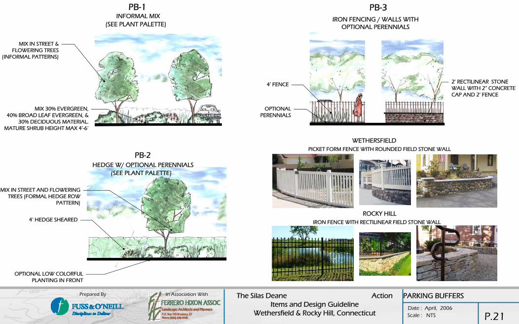
PB-1
PB-2
PB-3INFORMAL MIX
HEDGE W/ OPTIONAL PERENNIALS
IRON FENCING / WALLS WITH OPTIONAL PERENNIALS
OPTIONAL LOW COLORFUL PLANTING IN FRONT
OPTIONAL PERENNIALS
2’ RECTILINEAR STONE WALL WITH 2” CONCRETE CAP AND 2’ FENCE
4’ FENCE
MIX IN STREET AND FLOWERING TREES (FORMAL HEDGE ROW
PATTERN)
(SEE PLANT PALETTE)
(SEE PLANT PALETTE)
WETHERSFIELD
ROCKY HILL
MIX 30% EVERGREEN,40% BROAD LEAF EVERGREEN, &
30% DECIDUOUS MATERIAL.MATURE SHRUB HEIGHT MAX 4’-6’
4’ HEDGE SHEARED
MIX IN STREET & FLOWERING TREES
(INFORMAL PATTERNS)
IRON FENCE WITH RECTILINEAR FIELD STONE WALL
PICKET FORM FENCE WITH ROUNDED FIELD STONE WALL
PARKING BUFFERS
P.21

In Association With The Silas Deane Action Items and Design Guideline
Wethersfield & Rocky Hill, Connecticut Date : April, 2006
Prepared By
Scale : NTS
BOLLARDS
BUS SHELTER
BENCHESLIGHTING
WALLS
COBRA
ORNAMENTAL
CO
MM
ON
BO
TH T
OW
NS
IRON
CONCRETE W/ OPTIONAL CHAIN
CO
MM
ON
BO
TH T
OW
NS
BACK BACKLESS
BLOCK
CO
MM
ON
BO
TH T
OW
NS
(OPTIONAL BANNER ARMS)
CO
MM
ON
BO
TH T
OW
NS
WETHERSFIELD
ROUNDED FIELD STONE
ROCKY HILL
RECTILINEAR FIELD STONE
L 2
STREETSCAPE FURNITURE
P.22

In Association With The Silas Deane Action Items and Design Guideline
Wethersfield & Rocky Hill, Connecticut Date : April, 2006
Prepared By
Scale : NTS
CW-1 CW-2 CW-3
PAINTED CROSSWALK (BLUE)
BITUMINOUS PAVEMENT
BITUMINOUS PAVEMENT
STAMPED CONCRETE (8’ WIDE MIN)-COBBLE TEXTURE
STAMPED CONCRETE CROSSWALK (8’ WIDE MIN)
SEE L-2 FOR RECOMMENDED INTERSECTION RADIUS
STAMPED CONCRETE -BLUESTONE TEXTURE
NOTE: SEE WALKS FOR MATERIAL IMAGES
CROSSWALKS
P.23

In Association With The Silas Deane Action Items and Design Guideline
Wethersfield & Rocky Hill, Connecticut Date : April, 2006
Prepared By
Scale : NTS
BUILDING DESIGN GUIDELINES
Intersection Stories Pref Roof Form Style Pref ext mat Tenant Signage
I-1 Jordan Lane
RM 1 to 5 Larger Scale Contemporary Durable at grade Building Fascia - 10-18', 2' max height, uniform internally illuminated box signs at multi tennant buildings
N-S 1A Jordan Lane to C b l d
RM 1 to 8 Contemporary / Traditional
Contemporary / Traditional
Durable at grade Building Fascia - 10-18', 2' max height, uniform internally illuminated letter signs, uniform per building.
I-2 Cumberland Street
MU1 1 to 3 Contemporary / Traditional
Contemporary / Traditional
Durable at grade Building Fascia - 10-18', 18"' max height, externally illuminated.
N-S 2A Cumberland to Nott
MU1 2 to 3 Contemporary / Traditional
Contemporary / Traditional
Durable at grade Building Fascia - 10-18', 18"' max height, externally illuminated.
I-3Nott ST.
MU2 2 to 4 Contemporary / Traditional
Contemporary / Traditional
Durable at grade, Traditional
Building Fascia - 10-18', 18"' max height, externally illuminated.
N-S 2B Nott to Church TC 2 to 3 Traditional Contemporary / Traditional
Durable at grade, Traditional
Building Fascia - 10-18', 18"' max height, externally illuminated.
I-3 Church St.
TC 3 to 5 Public Scale - traditional
Traditional Durable, Traditional
Building Fascia - 10-18', 18"' max height, externally illuminated.
NS 3A Church to Welles.
TC 3 to 5 Contemporary / Traditional
Contemporary / Traditional
Durable, Traditional
Building Fascia - 10-18', 18" max height, uniform internally illuminated letter signs, uniform per building.
I-5 Welles Rd.
MU2 2 to 4 Traditional Durable, Traditional
Durable, Traditional
Building Fascia - 10-18', 18" max height, uniform internally illuminated letter signs, uniform per building.
N-S 2C Welles to Maple
MU1 2 to 3 Contemporary Contemporary / Traditional
Durable at grade Building Fascia - 10-18', 18" max height, uniform internally illuminated letter signs, uniform per building.
I-6 Maple Ave.
RM 2 to 3 Traditional / Contemporary
Durable Durable Building Fascia - 10-18', 18" max height, uniform internally illuminated letter signs, uniform per building.
N-S 1BMaple to Town Line Road
RM 1 to 8 Contemporary Contemporary Durable at grade Building Fascia - 10-18', 24" max height, uniform internally illuminated box signs, uniform per building.
EXISTING
Entrance/Canopy Building ColorsMajor buildings - enphasized main entry. Strip shopping, pedestrian canopy.
NR
Small buildings need entrance identification. NR
Individual buildings, offices - strong entrance identification.
NR
Individual buildings, offices - strong entrance identification.
NR
Individual buildings, offices - strong entrance identification.
earth tones toward town center
Major buildings - enphasized main entry. Strip shopping, pedestrian canopy.
earth tones toward town center
Major buildings - enphasized main entry. Strip shopping, pedestrian canopy.
earth tones
Major buildings - enphasized main entry. Strip shopping, pedestrian canopy.
earth tones
Major buildings - enphasized main entry. Strip shopping, pedestrian canopy.
earth tones for new structures and additions
Individual buildings, offices - strong entrance identification.
NR
earth tones for new structures and additions NR
Major buildings - enphasized main entry. Strip shopping, pedestrian canopy.
NR
ARCHITECTURAL GUIDELINESThe following architectural guidelines are intended for use as a tool both in renovation and new construction projects along the corridor. Similar to the streetscape recommendations, these guidelines break the corridor down into identifiable segments based on existing architectural styles and the development of a consistent theme of design. These guidelines support the nodal concept of development where styles, setbacks, building heights, etc. vary depending on where in the corridor the project may lie. The implementation of these guidelines will help promote an identifiable image and hierarchy of corridor spaces as recommended. These guidelines are to be used in conjunction with the land use recommendations and streetscape guidelines contained in this report. The streetscape guidelines include recommendations on building setbacks and height as well as otherstreetscape related elements.
•Objectives of the Guidelines -
Integrate good and rational design guidelines with the practical and economic needs of the owners, developers and users to improve the opportunity for long term stability and commercial success.
•Encourage and support renewal and development by developing guidelines that integrate investment and town goals.
•Support increased density by encouraging mixed use and pedestrian friendly design.
•Provide a “sense of place” on the corridor while encouraging a variety of high quality contemporary design and identity for neighborhoods along the corridor.
•Encourage highly legible signage and identification standards for drivers to more easily find merchants and locations.
INSTRUCTIONS TO THE USER:•THE USE OF THE GUIDELINE / CHART SYSTEM FOR ARCHITECTURAL GUIDELINES IS SIMILER TO AND COORDINATED WITH THE CHART SYSTEM FOR STREET SCAPE. EACH AREA IS IDENTIFIED BY ITS LOCATION WITHIN THE COORIDOR ( “I #” FOR INTERSECTIONS AND “NS # FOR OTHER COORIDOR SECTIONS). EACH SECTION IS FOLLOWED TO A COLOR CODED DESIGN DESIGNATION ( RM, MU1, MU2, TC ) WHICH IS KEYED TO SPECIFIC RECOMMENDATIONS ON THE FOLLOWING PAGES.
TOWN OF WETHERSFIELD
TOWN OF ROCKY HILL
I-7 Town Line Rd.
RM 1 to 5 Contemporary Contemporary Durable at grade Building Fascia - 10-18', 2' max height, uniform internally illuminated box signs, uniform per building.
NS-1C Town Line Rd. to
RM 1 to 5 Contemporary Contemporary Durable at grade Building Fascia - 10-18', 2' max height, uniform internally illuminated letter signs, uniform per building.
I-8 Parsonage St.
MU1 2 to 3 Contemporary Contemporary Durable at grade Building Fascia - 10-18', 18" max height, uniform internally illuminated letter signs, uniform per building.
NS-2D Parsonage St. to Elm St.
MU2 2 to 3 Traditional / Contemporary
Traditional / Contemporary
Durable at grade Building Fascia - 10-18', 18" max height, uniform internally illuminated letter signs, uniform per building.
I-9 Elm St.
TC 2 to 5 public scale - traditional
Durable, Traditional
Durable, Traditional
Building Fascia - 10-18', 18" max height, uniform internally illuminated letter signs, uniform per building.
NS-3B Elm St. to Dividend
TC 2 to 4 Large scale contemporary
Contemporary Durable Building Fascia - 10-18', 2' max height, uniform internally illuminated letter signs, uniform per building.
Major buildings - enphasized main entry. Strip shopping, pedestrian canopy.
NR
Major buildings - enphasized main entry. Strip shopping, pedestrian canopy.
NR
Major buildings - enphasized main entry. Strip shopping, pedestrian canopy.
NR
Major buildings - enphasized main entry. Strip shopping, pedestrian canopy.
Earth tones closer to town center
Major buildings - enphasized main entry. Strip shopping, pedestrian canopy.
earth tones
Major buildings - enphasized main entry. Strip shopping, pedestrian canopy.
earth tones
ARCHITECTURE
P.24

In Association With The Silas Deane Action Items and Design Guideline
Wethersfield & Rocky Hill, Connecticut Date : April, 2006
Prepared By
Scale : NTS
TC -TOWN CENTER DESIGN PREFERENCESMIXED USE
•STRONG TRADITIONAL ROOFLINES, SLOPED ROOFS WITH GABLES OR HIPS, FLAT ROOFS WITH CORNICES OR DECORATED PARAPETS. ROOFING MATERIAL – SHINGLES OR METAL ROOFING, COLORS -GRAYS, BROWNS REDS AND GREENS
•DURABLE AND PERMANENT BUILDING EXTERIOR MATERIALS – BRICK, STONE, CONCRETE – FOCUS ON EARTH TONES
•OFFICE AND APARTMENT ENTRANCES ARE EMPHASIZED AND TRANSITION WITH OVERHANGS AND VESTIBULES
•SIGNAGE RESTRICTED TO SIGN FASCIA, UNIFORM LETTERING
•RETAIL BUILDINGS HAVE SHOW WINDOWS AND CONTINUOUS CANOPIES FOR PEDESTRIAN BROWSING.
•RESTAURANTS MAY HAVE OUTDOOR SEATING.
•COLORS RESTRICTED TO EARTH TONES.
•REAR AND SIDE YARD SCREENING OF UTILITY AREAS AND MECHANICAL EQUIPMENT.
TOWN CENTER – MIXED USE TOWN CENTER – MUNICIPAL BUILDING
TOWN CENTER -OFFICE TOWN CENTER -MIXED USE BUILDING
MU1 -MIXED USE DESIGN PREFERENCESRETAIL, RESTAURANT
MODULATED ROOFLINES, SLOPED ROOFS, GABLES OR HIPS EXPOSED TO THE STREET OR, FLAT ROOFS WITH PEDIMENT OR ARCH FORMS.
DURABLE AND PERMANENT BUILDING MATERIALS TO TOP OF FIRST FLOOR WINDOWS – BRICK, STONE, CONCRETE, CONCRETE BLOCK AND FAUX STONE VENEER.
CONTINUOUS PEDESTRIAN CANOPIES.
SIGNAGE RESTRICTED TO GROUND BASED ID SIGNAGE AND SIGN FASCIA WITH UNIFORM LETTERING.
COLORS NOT RESTRICTED, BUT LOCAL DESIGN REVIEW.
STRIP SHOPPING CENTER WITH STRONG ROOF FORMS
RESTAURANT – ROOF SEATING
ARCHITECTURE
GROCERY STORE WITH EASY PEDESTRIAN STREET ACCESS
MIXED USE – OFFICE OVER RESTAURANT, OUTDOOR SEATING
P.25

In Association With The Silas Deane Action Items and Design Guideline
Wethersfield & Rocky Hill, Connecticut Date : April, 2006
Prepared By
Scale : NTS
MU1 -MIXED USE DESIGN PREFERENCESOFFICE, APARTMENT
•MODULATED ROOFLINES, SLOPED ROOFS, GABLES OR HIPS EXPOSED TO THE STREET OR, FLAT ROOFS WITH PEDIMENT OR ARCH FORMS.
•DURABLE AND PERMANENT BUILDING MATERIALS TO TOP OF FIRST FLOOR WINDOWS – BRICK, STONE, CONCRETE, CONCRETE BLOCK AND FAUX STONE VENEER.
•STRONG ENTRY IDENTIFICATION, TRANSITIONAL ENTRIES.
•SIGNAGE RESTRICTED TO GROUND BASED ID SIGNAGE AND SIGN FASCIA WITH UNIFORM LETTERING.
•TRADITIONAL AND DURABLE EXTERIOR MATERIALS, BRICK, STONE, CLAPBOARD SIDINGS, METAL AND ASPHALT SHINGLE ROOFING
•COLORS NOT RESTRICTED, BUT LOCAL DESIGN REVIEW.
APARTMENT WITH STRONG ENTRY
OFFICE WITH STRONG ENTRY
MU2 -MIXED USE DESIGN PREFERENCES RETAIL, OFFICE, APARTMENT
•MODULATED ROOFLINES, SLOPED ROOFS, GABLES OR HIPS EXPOSED TO THE STREET OR, FLAT ROOFS WITH PEDIMENT OR ARCH FORMS.
•STRONG ENTRY IDENTIFICATION, TRANSITIONAL ENTRIES.
•SIGNAGE RESTRICTED TO GROUND BASED ID SIGNAGE AND SIGN FASCIA WITH UNIFORM LETTERING.
•TRADITIONAL AND DURABLE EXTERIOR MATERIALS, BRICK, STONE, CONCRETE, CONCRETE BLOCK AND FAUX STONE VENEER, METAL AND ASPHALT SHINGLE ROOFING
•COLORS 60% EARTH TONES ON EXTERIOR, 20% OF FAÇADE VISIBLE ROOF FORM.
•FULL SCREENING OF MECHANICAL EQUIPMENT AND LOADING.
MIXED USE – OFFICE OVER RETAIL, TRADITIONAL
OFFICE WITH TRADITIONAL FORM MATERIALS AND ROOF
ARCHITECTURE
MIXED USE – OFFICE OVER RETAIL
BRANCH OFFICE, CONTEMPORARY STYLE
OFFICE WITH STRONG TRADITIONAL FORM
RETAIL – CONTEMPORARY WITH STRONG TRADITIONAL ELEMENTS.
P.26
In Association With The Silas Deane Action Items and Design Guideline
Wethersfield & Rocky Hill, Connecticut Date : April, 2006
Prepared By
Scale : NTS
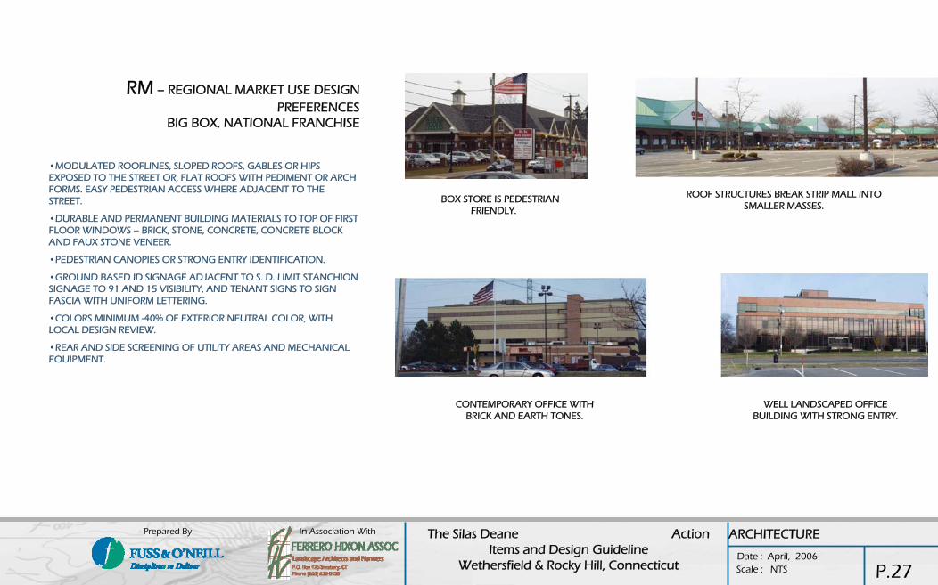
RM – REGIONAL MARKET USE DESIGN PREFERENCES
BIG BOX, NATIONAL FRANCHISE
•MODULATED ROOFLINES, SLOPED ROOFS, GABLES OR HIPS EXPOSED TO THE STREET OR, FLAT ROOFS WITH PEDIMENT OR ARCH FORMS. EASY PEDESTRIAN ACCESS WHERE ADJACENT TO THE STREET.
•DURABLE AND PERMANENT BUILDING MATERIALS TO TOP OF FIRST FLOOR WINDOWS – BRICK, STONE, CONCRETE, CONCRETE BLOCK AND FAUX STONE VENEER.
•PEDESTRIAN CANOPIES OR STRONG ENTRY IDENTIFICATION.
•GROUND BASED ID SIGNAGE ADJACENT TO S. D. LIMIT STANCHION SIGNAGE TO 91 AND 15 VISIBILITY, AND TENANT SIGNS TO SIGN FASCIA WITH UNIFORM LETTERING.
•COLORS MINIMUM -40% OF EXTERIOR NEUTRAL COLOR, WITH LOCAL DESIGN REVIEW.
•REAR AND SIDE SCREENING OF UTILITY AREAS AND MECHANICAL EQUIPMENT.
BOX STORE IS PEDESTRIAN FRIENDLY.
WELL LANDSCAPED OFFICE BUILDING WITH STRONG ENTRY.
ARCHITECTURE
ROOF STRUCTURES BREAK STRIP MALL INTO SMALLER MASSES.
CONTEMPORARY OFFICE WITH BRICK AND EARTH TONES.
P.27
In Association With The Silas Deane Action Items and Design Guideline
Wethersfield & Rocky Hill, Connecticut Date : April, 2006
Prepared By
Scale : NTS
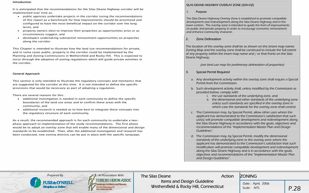
Introduction It is anticipated that the recommendations for the Silas Deane Highway corridor will be implemented over time as:
• public agencies undertake projects in the corridor (using the recommendations of this report as a benchmark for how improvements should be prioritized and configured to have the most beneficial impact on the corridor over the long term), and
• property owners elect to improve their properties as opportunities arise or as circumstances suggest, and
• developers undertaking substantial reinvestment opportunities on properties along the corridor.
This Chapter is intended to illustrate how the land use recommendations for private, and in some cases public, property in the corridor could be implemented by the Planning and Zoning Commissions in Wethersfield and Rocky Hill. This is expected to occur through the adoption of zoning regulations which will guide private activities in the corridor. General Approach This section is only intended to illustrate the regulatory concepts and mechanics that are suggested for the corridor at this time. It is not intended to define the specific provisions that would be necessary as part of adopting a regulation. There are several reasons for this:
• additional investigation is needed in each community to define the specific boundaries of the land use areas and to confirm these areas with the community, and
• additional research is needed as to how best to integrate these concepts into the regulatory structure of each community.
As a result, the recommended approach is for each community to undertake a two-phase approach to implementation of the study recommendations. The first phase would be to adopt an overlay zone that will enable many of the dimensional and design standards to be established. Then, after the additional investigation and research has been conducted, new zoning districts can be put in place with the specific language,
SILAS DEANE HIGHWAY OVERLAY ZONE (SDH-OZ) 1. Purpose The Silas Deane Highway Overlay Zone is established to promote compatible development and redevelopment along the Silas Deane Highway and in the town centers. The overlay zone is intended to guide the form of improvements on public and private property in order to encourage economic reinvestment and enhance community character. 2. Zone Delineation The location of the overlay zone shall be as shown on the (insert map name) Zoning Map and the overlay zone shall be construed to include the full extent of any property within the insert map name and / or that fronts on the Silas Deane Highway.
(see land use map for preliminary delineation of properties) 3. Special Permit Required
a. Any development activity within the overlay zone shall require a Special Permit from the Commission.
b. Such development activity shall, unless modified by the Commission as provided below, comply with:
i. the use standards of the underlying zone, and ii. the dimensional and other standards of the underlying zone
unless such standards are specified in the overlay zone in which case the standards for the overlay zone shall control.
c. The Commission may, by Special Permit, allow other uses where the applicant has demonstrated to the Commission’s satisfaction that such use(s) will promote compatible development and redevelopment along the Silas Deane Highway in accordance with the goals, objectives and recommendations of the “Implementation Master Plan and Design Guidelines”.
d. The Commission may, by Special Permit, modify the dimensional standards of the underlying zone or the overlay zone where the applicant has demonstrated to the Commission’s satisfaction that such modification will promote compatible development and redevelopment along the Silas Deane Highway and is in accordance with the goals, objectives and recommendations of the “Implementation Master Plan and Design Guidelines”.
ZONING
P.28

In Association With The Silas Deane Action Items and Design Guideline
Wethersfield & Rocky Hill, Connecticut Date : April, 2006
Prepared By
Scale : NTS
The following text is suggested to be included within the overlay zone (or the overall Zoning Regulations) in order to help encourage property owners to consolidate their parcels for the purposes of development. Experience has shown that such a provision encourages the interconnection and consolidated development of property and can result in more floor area for the owners with better results for the community.
5. Consolidated Parcel Provision (if needed)
For the purpose of integrated development, any number of contiguous parcels may be consolidated for the purpose of development, and the consolidated parcel shall be construed to be one lot when computing building coverage and yard requirements, and permitted uses, provided:
a. The owner of each lot shall give to the owner of each lot in the consolidated Parcel by deed, easement, or agreement filed in the Office of the Town Clerk, the right of entrance, exit, passage, parking and loading.
b. The consolidated parcel is developed with an integrated plan of buildings, parking, loading and unloading, and open space.The Commission may require or limit use of access driveways to one or more parcels, whether or not under separate ownership, in order to assure safe traffic movement onto the street and to avoid congestion.
6. Access Management Requirements (if needed)
1. Purpose - This section is intended to control the number, size, and location of driveways and access points for business uses in order to promote overall traffic control and promote public safety and welfare in accordance with the Implementation Master Plan and Design Guidelines document
2. Considerations - The Commission shall review parking layout and configuration, traffic circulation within the site, the number and location of access points to and from the site, and the nature and type of traffic circulation on adjacent roadways to ensure that public safety and welfare is promoted with the greatest efficiency.
3. Requirements -• Where street geometry, traffic volumes or traffic patterns warrant, the Commission
may, in general conformance with the Implementation Master Plan and Design Guidelines document:
• limit the number of driveways that serve a specific site, • designate the location of any driveway, • require the use or provision of a shared driveway with associated easements, and • limit access to a major street and require access from a minor street• As part of application approval, the Commission may require an applicant or owner
to:• establish mutual driveway or other easement(s) to provide a single point of access for
two or more abutting properties in a location acceptable to the Commission and the Traffic Authority,
• file such easement(s) on the land records in favor of the abutting property owners and/or the Town as shall be acceptable to the Commission and the Town Attorney, and/or utilize a mutual driveway or other easement that exists on abutting property in lieu of having a separate curb cut onto a road or street.
4. Regulating Plans / Schedules
a. The following regulating plans shall be referred to for any development activity proposed w ithin the Silas Deane Highway Overlay Zone.
b. The “Im plementation Master Plan and Design Guidelines” including all subsequent detail sheets prepared by Fuss & O ’Neill and Ferrero Hixon Associates including the Land Use Recom m endations, Transportation recom m endations, Streetscape Design Guidelines, and Architectural Design Guidelines (or other plan(s) adopted by the Comm ission) shall be used for identifying:
The following text is suggested to be included within the overlay zone (or the overall Zoning Regulations) in order to help encourage on-street parking (where appropriate) and shared access and parking.
ZONING
P.29
In Association With The Silas Deane Action Items and Design Guideline
Wethersfield & Rocky Hill, Connecticut Date : April, 2006
Prepared By
Scale : NTS
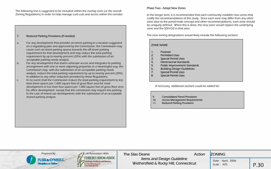
Phase Two - Adopt New Zones
In the longer term, it is recommended that each community establish new zones that codify the recommendations of this study. Since each zone may differ from any other zone (due to the portal-node concept and other recommendations), each zone should be uniquely defined. When this is done, the new zone would replace the underlying zone and the SDH-OZ in that area.
The new zoning designations would likely include the following sections:
ZONE NAME
1. Purpose2. Permitted Uses3. Special Permit Uses4. Dimensional Standards5. Public Improvement Standards6. Building Design Guidelines7. Special Permit Uses8. Special Permit Uses
If necessary, additional sections could be added for:
9. Consolidated Parcel Provisions10. Access Management Requirements11. Reduced Parking Provisions
7. Reduced Parking Provisions (if needed)
a. For any development that provides on-street parking in a location suggested on a regulating plan and approved by the Commission, the Commission may count such on-street parking spaces towards the off-street parking requirement for that development and may reduce the total parking requirement by up to twenty percent (20%) with the submission of an acceptable parking needs analysis.
b. For any development that shares vehicular access and integrates its parking arrangement with one or more adjoining properties in a meaningful way, the Commission may, with the submission of an acceptable parking needs analysis, reduce the total parking requirement by up to twenty percent (20%) in addition to any other reduction provided by these Regulations.
c. In no event shall the Commission reduce the total parking requirement to less than three spaces per 1,000 square feet of gross floor area for retail development or less than four spaces per 1,000 square feet of gross floor area for office development except that the commission may require less parking In the case of mixed use developments with the submission of an acceptable shared parking analysis.
ZONING
The following text is suggested to be included within the overlay zone (or the overall Zoning Regulations) in order to help manage curb cuts and access within the corridor.
P.30
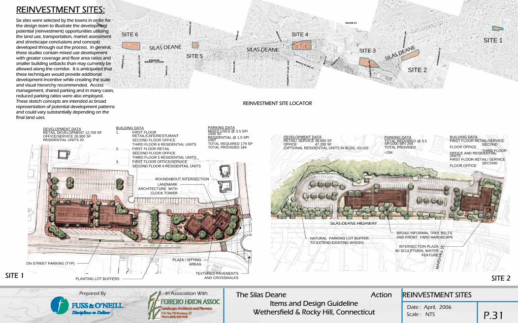
In Association With The Silas Deane Action Items and Design Guideline
Wethersfield & Rocky Hill, Connecticut Date : April, 2006
Prepared By
Scale : NTS
SITE 1
ON STREET PARKING (TYP)
PLANTING LOT BUFFERS
PLAZA / SITTING AREAS
ROUNDABOUT INTERSECTIONLANDMARK
ARCHITECTURE WITHCLOCK TOWER
TEXTURED PAVEMENTS AND CROSSWALKS
BUILDING DATA1. FIRST FLOOR
RETAIL/CAFÉ/RESTURANTSECOND FLOOR OFFICETHIRD FLOOR 6 RESIDENTIAL UNITS
2. FIRST FLOOR RETAILSECOND FLOOR OFFICETHIRD FLOOR 5 RESIDENTIAL UNITS
3. FIRST FLOOR OFFICE/SERVICESECOND FLOOR 9 RESIDENTAIL UNITS
DEVELOPMENT DATARETAIL DEVELOPMENT 12,700 SFOFFICE/SERVICE 26,900 SFRESIDENTIAL UNITS 20
PARKING DATAMIXED USES @ 3.5 SP/ 1000 SFRESIDENTIAL @ 1.5 SP/ UNITTOTAL REQUIRED 179 SPTOTAL PROVIDED 184
1
23
SITE 2
DEVELOPMENT DATARETAIL/ SERVICE 36,600 SFOFFICE 47,200 SF(OPTIONAL RESIDENTIAL UNITS IN BLDG, #1=10)
NATURAL PARKING LOT BUFFER TO EXTEND EXISTING WOODS
BROAD INFORMAL TREE BELTS AND FRONT YARD HARDSCAPE
INTERSECTION PLAZAW/ SCULPTURAL WATER
FEATURE
PARKING DATATOTAL REQUIRED @ 3.5 SP/1000 SF= 294 TOTAL PROVIDED =294
BUILDING DATAFIRST FLOOR RETAIL/SERVICE
SECOND FLOOR OFFICE
THIRD FLOOR OFFICE AND RESIDENTIAL UNITSFIRST FLOOR RETAIL/ SERVICE
SECOND FLOOR OFFICE
SITE 1
SITE 2
SILAS DEANE SILAS DEANE
SILAS DEANESITE 3
SITE 6
SITE 5
SITE 4
REINVESTMENT SITE LOCATOR
REINVESTMENT SITES:Six sites were selected by the towns in order for the design team to illustrate the development potential (reinvestment) opportunities utilizing the land use, transportation, market assessment and streetscape conclusions and concepts developed through out the process. In general, these studies contain mixed use development with greater coverage and floor area ratios and smaller building setbacks than may currently be allowed along the corridor. It is anticipated that these techniques would provide additional development incentive while creating the scale and visual hierarchy recommended. Access management, shared parking and in many cases, reduced parking ratios were also employed. These sketch concepts are intended as broad representation of potential development patterns and could vary substantially depending on the final land uses.
REINVESTMENT SITES
P.31
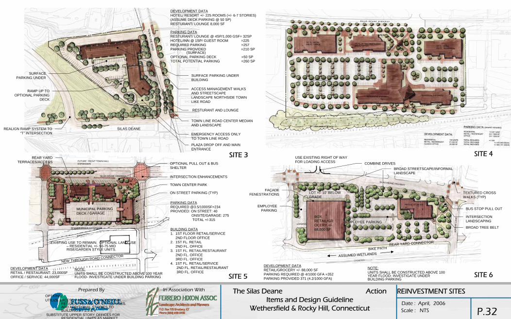
In Association With The Silas Deane Action Items and Design Guideline
Wethersfield & Rocky Hill, Connecticut Date : April, 2006
Prepared By
Scale : NTS
SITE 3
DEVELOPMENT DATAHOTEL/ RESORT +/- 225 ROOMS (+/- 6-7 STORIES) (ASSUME DECK PARKING @ 50 SP)RESTURANT/ LOUNGE 8,000 SF
ACCESS MANAGEMENT WALKSAND STREETSCAPE LANDSCAPE NORTHSIDE TOWN LIKE ROAD
RESTURANT AND LOUNGE
SURFACE PARKING UNDER BUILDING
TOWN LINE ROAD CENTER MEDIANAND LANDSCAPE
EMERGENCY ACCESS ONLY TO TOWN LINE ROAD
PLAZA DROP OFF AND MAIN ENTRANCE
SILAS DEANE
PARKING DATARESTURANT/ LOUNGE @ 4SP/1,000 GSF= 32SPHOTEL/INN @ 1SP/ GUEST ROOM =225REQUIRED PARKING =257PARKING PROVIDED =210 SP
(SURFACE)OPTIONAL PARKING DECK =50 SPTOTAL POTENTIAL PARKING =260 SP
SURFACE PARKING UNDER
RAMP UP TO OPTIONAL PARKING
DECK
REALIGN RAMP SYSTEM TO “T” INTERSECTION
DEVELOPMENT DATARETAIL / RESTAURANT: 23,000SFOFFICE / SERVICE: 44,000SF
PARKING DATAREQUIRED @3.5/1000SF=234PROVIDED: ON STREET: 40
ONSITE/GARAGE: 275TOTAL +/-315
1
2 3
4
SILAS DEANE HIGHWAY
CH
UR
CH
ST R
EE
T
EXISTING USE TO REMAIN. OPTIONAL LAND USE – RESIDENTIAL +/- 50-75 MID RISE/GARDEN STYLE UNITS.
BIKE PATH
ON STREET PARKING (TYP)
TOWN CENTER PARK
INTERSECTION ENHANCEMENTS
OPTIONAL PULL OUT & BUS SHELTER
FUTURE FRONT TOWN HALL EXPANSION
BUILDING DATA1. 1ST FLOOR RETAIL/SERVICE
2ND FLOOR OFFICE2. 1ST FL. RETAIL
2ND FL. OFFICE3. 1ST FL. RETAIL/RESTAURANT
2ND FL. OFFICE3RD FL. OFFICE
4. 1ST FL. RETAIL/SERVICE2ND FL. RETAIL/RESTAURANT3RD FL. OFFICE
OPTIONS:UTILIZE EXCESS PARKING FOR ADDITIONAL
RESIDENTIAL AND, OR OFFICE USES. ADD ADDITIONAL STORIES TO BUILDINGS # 2,3 & 4
SUBSTITUTE UPPER STORY OFFICES FOR RESIDENTIAL UNITS AS MARKET
NEW THROUGH ROAD CONNECTOR
BEAVER BROOK EXTENSION
MUNICIPAL PARKING DECK / GARAGE
REAR YARD TERRACES/ACCESS
NOTE:UNITS SHALL BE CONSTRUCTED ABOVE 100 YEAR FLOOD- INVESTIGATE UNDER BUILDING PARKING SITE 6
BUS STOP PULL OUT
LOT +/- 10’ BELOW GRADE
TEXTURED CROSS WALKS (TYP)
INTERSECTION LANDSCAPING
BROAD TREE BELT
JOR
DA
N L
AN
E
SILAS DEANE HIGHWAY
BROAD STREETSCAPE/INFORMAL LANDSCAPE
USE EXISTING RIGHT OF WAY FOR LOADING ACCESS
FAÇADE FENESTRATIONS
EMPLOYEE PARKING
LOADING
BOX RETAIL/GROCERY +/-68,000 SF
1
2
RETAIL +/- 20,000 SF
BIKE PATH
EMPLOYEE PARKING
REAR YARD CONNECTOR
ASSUMED WETLANDS
DEVELOPMENT DATARETAIL/GROCERY +/- 88,000 SFPARKING REQUIRED @ 4/1000 GFA =352PARKING PROVIDED 371 (4.2/1000 GFA)
COMBINE DRIVES
NOTE:UNITS SHALL BE CONSTRUCTED ABOVE 100 YEAR FLOOD- INVESTIGATE UNDER BUILDING PARKING
SITE 4
SITE 5
REINVESTMENT SITES
P.32

In Association With The Silas Deane Action Items and Design Guideline
Wethersfield & Rocky Hill, Connecticut Date : April, 2006
Prepared By
Scale : NTS
LANDMARK CORNER ARCHITECTURE WITH CLOCK
TOWER
PARKING LOT BUFFERS
ORNAMENTAL LIGHTS WITH BANNER ARMS (TYP)
ROUTE BUS PULL-OFF AND SHELTER
CREATE TOWN CENTER PLAZA ON TOWN LAND. WATER FEATURE, STONE WALLS, FLAG POLES, BUS SHELTERS, ETC.
NEW ORNAMENTAL SIGNAL POLES (TYP)
PROMOTE ON-STREET DIAGONAL PARKING
LARGE SCULPTURAL PARK ENTRANCE PYLONS
INTERSECTION PLAZA WITH SEATING
TOWN CENTER PARK WITH SECONDARY ARCHITECTURE/ BUILDINGS. PROMOTE OUTDOOR
USES/ EVENTS. LARGE LAWN AREAS WITH PERIMETER URBAN PLAZAS AND AMENITIES
BOLLARDS WITH CHAINS (OPTIONAL) (TYP)
SPECIALITY PAVING (TYP)
TOWN CENTER- WETHERSFIELD
P.33

In Association With The Silas Deane Action Items and Design Guideline
Wethersfield & Rocky Hill, Connecticut Date : April, 2006
Prepared By
Scale : NTS
LANDMARK/ SIGNATURE BUILDING-PEDESTRIAN USES, ENTERTAINMENT, RESTAURANT, RETAIL, ETC
STORE FRONT STREET PLACES
NEW REINVESTMENT BUILDINGS CLOSE TO STREET (TYP)
LANDMARK ARCHITECTURE AT INTERSECTIONS
LARGE WATER FEATURE
CLOCK TOWER
PARKING LOT BUFFERS
SPECIALTY PAVEMENTS (TYP)
MEMORIAL MONOLITH STONES (TYP)
LOW CONCRETE BOLLARDS WITH CHAINS (TYP)
TOWN GREEN
PLAZA
HIGHLIGHT CHURCH LANDMARK
ORNAMENTAL LIGHTS WITH BANNER ARMS (TYP)
REAR YARD PARKING AREAS WITH CONNECTIONS TO STREET
SILAS D
EAN
E
MAIN STREET
ELM STREET
TOWN CENTER- ROCKY HILL
P.34

In Association With The Silas Deane Action Items and Design Guideline
Wethersfield & Rocky Hill, Connecticut Date : April, 2006
Prepared By
Scale : NTS
ACTION ITEMS
Land Use1. Overlay Zoning2. Encourage housing component through mixed use projects3. Density bonuses, and other incentives to reinvestment4. Town center master plan – Rocky Hill5. Beaver Brook implementation6. Brownfield Grants7. Public / Private partnerships for mixed use redevelopment8. Transit oriented development
Transportation1. Access management program to interact with business owners2. New sidewalk connections3. Pedestrian push button, signals, and curb ramp upgrades4. ConnDOT coordination for transportation funding through Federal programs5. Wayfinding sign system6. Long term use of the Valley rail line as a commuter rail7. Multi use trail adjacent to the railroad corridor8. Design , permitting and construction of transportation recommendations
Preliminary engineering and cost estimateConnDOT review and commentSemi Final DesignPermits and final estimateFinal DesignBid, award, construction
Brand / ImageEncourage the use of streetscape details in new projectsMarketing campaign for “The Silas Deane” as a borough, and as a destination
StreetscapeAnnual maintenance budget for streetscape and landscaping elementsNortheast Utilities partnership for encouraging reinvestment and reducing overhead power linesAnnual budget for removing overhead power lines: Town centers first, then overhead crossingsArchitecturalWethersfield express façade improvement program to use design guidelines
STREETSCAPE
Streetscape1. Annual maintenance budget for streetscape and landscaping elements2. Northeast Utilities partnership for encouraging reinvestment and reducing overhead power lines3. Annual budget for removing overhead power lines: Town centers first, then overhead crossings4. Architectural5. Wethersfield express façade improvement program to use design guidelines
Projects implementation priority1. Town Centers in each Town2. Gateway at I-913. Small business / mixed use district4. Regional commercial areas
P.35