web-based environmental simulation: bridging the gap between scientific modeling and decision-making
TRANSCRIPT
Web-Based Environmental Simulation: Bridging the Gap betweenScientific Modeling and Decision-MakingWouter Buytaert,*,† Selene Baez,‡ Macarena Bustamante,‡ and Art Dewulf §
†Civil and Environmental Engineering and Grantham Institute for Climate Change, Imperial College London, Skempton Building,SW7 2AZ London, U.K.
‡CONDESAN, Quito, Ecuador§Public Administration and Policy Group, Wageningen University, Wageningen, The Netherlands
■ INTRODUCTIONData availability in environmental sciences is expanding ata rapid pace. From the constant stream of high-resolutionsatellite images to the local efforts of citizen scientists, there is anincreasing need to process the growing stream of heteroge-neous data and turn it into useful information for decision-making. Environmental models, ranging from simple rainfall−runoff relations to complex climate models, can be very usefultools to process data, identify patterns, and help predict thepotential impact of management scenarios. But the complexityof most environmental models typically confines them toscientific laboratories and academic computer clusters, wherethey are harnessed by researchers who understand the algo-rithms, assumptions, simplifications, and potential errors ofthese models. As a result, decision-makers often have high andunrealistic expectations regarding scientific knowledge andenvironmental models. The risk exists that they will see themas clear-cut cases for particular policies,1 or contrarily, theymay lack confidence in models and results that they cannotreproduce themselves. The integration of information providedby environmental models into policy formulation is thereforequite a challenge. In their efforts, scientists and decision-makersmay be helped or criticized by third parties of citizen scien-tists collecting local data2 and challenging model results andmanagement decisions.Recent technological innovations in networking and com-
puting (among which those that underpin the interactiveWeb 2.0) may bring a new generation of interactive modelsplugged into virtual environments closer to the end-user. Theyare the driver of major funding initiatives such as the UK’sVirtual Observatory program, and the U.S. National ScienceFoundation’s Earth Cube. Even though the intricacies of codedevelopment and data assimilation themselves may still behidden in laboratories and supercomputer centers, various in-terfaces may allow end-users to interact with them more
directly, requesting particular scenarios and tailored simula-tions. Such “do-it-yourself” simulation has the potential to turnthe typical top-down flow of information from scientists tousers into a much more direct, interactive approach. It opensperspectives to speed up the dissemination of environmentalinformation to a larger community of users, to harvest feedback,and to widen the opportunity to evaluate simulations andpredictions from different perspectives. However, this evolutioncomes with the challenge of communicating modeled results insuch a way that they can be interpreted correctly and are notused in an inappropriate context.
■ INCREASING NEEDS FOR ENVIRONMENTAL DATAPROCESSING AND SIMULATION
For the indigenous communities of the Pacaya-Samira NationalReserve in the Peruvian Amazon, turtle egg harvesting is a suc-cessful survival strategy. The practice keeps the natural animalpopulation numbers up and provides a necessary source of foodand income. However, the success of the activity is dependenton information on the variability in the river level, which mayflood nesting beaches at crucial times. In the Yasuni NationalPark in the Ecuadorian Amazon, bush meat hunting regions arethreatened by encroaching deforestation. Further upstream, inAndean highlands of Ecuador and Peru, the availability andquality of irrigation water depends strongly on upland landmanagement, as well as the reliability of precipitation andglacier melt, which future climate change may affect.3
In these areas and in many others worldwide, a sustainablemanagement of the natural resources is crucial for local socio-economic development. The given examples face very differentenvironmental problems. But in all of them, data and resourcestend to be scarce compared to the complexity of the issuesfaced. It is therefore essential that local managers have optimalaccess to existing data and simulation methods to design man-agement strategies, and optimize ecosystem management andhuman development.Many developed countries also struggle to manage ecosystem
resources in a context of accelerating environmental change.Data availability may be less of an issue here, but the data comein many different forms and formats, and are collected andstored by a plethora of different institutes and entities. The in-creasing stress on environmental processes requires that man-agement strategies take into account the complexity of stronglyinterconnected environmental and socio-economic systems.
Published: January 17, 2012
Feature
pubs.acs.org/est
© 2012 American Chemical Society 1971 dx.doi.org/10.1021/es2031278 | Environ. Sci. Technol. 2012, 46, 1971−1976
Resolving the interactions between different processes in inte-grated models is a convenient approach to understand thepotential impact of management and policy decisions. TheVirtual Observatory program of the UK Natural EnvironmentResearch is one of several attempts to create a common plat-form for environmental data, models, and decision supportsystems. In the U.S., the recently announced Earth Cubeinitiative of the National Science Foundation has similaraims, as has the Global Earth Observation System of System(GEOSS). They all aim at providing environmental simulationsand predictions that result from advanced integration of climatic,hydrological, ecological, social and other data to informmanagement decisions.However, not only in large-scale virtual observatories, but
also in small scale citizen science,4 there is a growing need formore integration in sharing and processing of data and informa-tion. Although the accuracy of a single sensor or amateurobservation is often less than that of a more expensive alterna-tive, the ability to employ them in large quantities may providevaluable information, for instance where spatial patterns arehighly variable or of particular importance. Such data collectionis often driven by citizens or environmental managers with alocal interest. It is therefore paramount that any scientificknowledge generated from these data is fed back to the datacollectors, either to support local ecosystem management, or asan education process to increase the lifespan of a community-based monitoring system.In the above-mentioned example of improving irrigation
in the Andes, one of the main issues is the lack of hydro-meteorological data. As in many other regions the number ofhydrometeorological stations in the region has been in gradualdecline since in the 1980s.5 Existing monitoring networks areconcentrated in valleys where most of the economic activityhappens. This is of little help to smallholder farmers in themountain headwaters, such as those of the Pacaipampa regionin northern Peru. With the help of local organizations they tryto improve agricultural practices to make their farming on steepslopes more sustainable, and to reconcile human activities withthe conservation of valuable wetland ecosystems.6 Recognizingthat basic information on precipitation and streamflow is essen-tial to a better understanding of the local hydrology, the farmersof Pacaipampa have installed electronic rain and streamflowgauges. Data are collected by a local organization and processedfor basic visualization.7
The results of the project are positively received by the localcommunity. It allows them to identify headwater catchmentswith a strong water regulation, which should be left undisturbedas water supply areas. But the potential of such projects is muchlarger. Although raw data are useful for understanding local pro-cesses such as runoff generation dynamics and water yield,water managers are more interested in anticipating the potentialimpact of management scenarios, such as reforestation, exclu-sion of livestock, and restoration of wetlands. Typically, theseimpacts are predicted using physically based hydrological models.However, implementing environmental models for complex
regions such as the tropical Andes is challenging. Becausemodels are complex, scientists are needed to develop and runthem. To do so, scientists often need local data and insights.At the other end, users may benefit from better interactionwith model developers to understand the model’s abilities anddeficiencies. Therefore, more interaction and exchange amongdata collectors, model developers, and end-users/decisionmakers is needed. This may lead to a rich two-way learning
process, which may yield new evaluation strategies and quickermodel improvement. Applying models that continuously incor-porate new data and knowledge within an adaptive manage-ment cycle can provide better outcomes in the context of un-certainty8 and offer the opportunity to incorporate citizenscientists’ feedback. Such a process is now becoming easierthrough web-enabled data processing.
■ UBIQUITOUS SENSING, SOFTWARE INTEGRATION,AND THE ROLE OF WEB SERVICES
Driven by technological developments, environmental sensorsare becoming smaller, cheaper, and increasingly automated.They can be employed in pervasive sensor networks9 andconnected to the Internet where they provide constant streamsof data.10 Similarly, environment agencies worldwide are start-ing to put historical and recent data online, helped by emergingstandards for data formatting and access.11 The need to processthese data efficiently has driven the development of workflowmanagement systems to facilitate data processing.12 Increas-ingly, these tools are web-enabled. Not only does this facilitatetheir deployment, avoiding the need to install software on aparticular machine, it has several other advantages. Processing-or memory-intensive parts of the analysis can be delegated tocommercial cloud computing facilities. This speeds up pro-cessing, especially for tasks that involve large, parallel calcula-tions, as is typical for uncertainty analyses (e.g., Markov ChainMonte Carlo methods). Another advantage is that modelcomponents can be hosted online. For instance, rather thanhaving to download and install a rainfall−runoff model, it maybe made available as a web service by a commercial company orresearch group, allowing users to send off the input data and getthe output data in return.13
Technologies for the deployment of model components on-line are currently under development. For instance, the OpenGeospatial Consortium’s (OGC) Web Processing Service14
provides rules for standardizing how inputs and outputs (req-uests and responses) for geospatial processing services need tobe formulated. The standard also defines how a client canrequest the execution of a process, and how the output fromthe process is handled. Similarly, data models are being definedto facilitate the unambiguous exchange of information betweendifferent models, as well as metadata including uncertainties.Notable examples are the Observations Data Model developedby the Consortium of Universities for the Advancement ofHydrological Sciences Inc. (CUAHSI15), now being adopted aspart of the suite of standards of OGC, or OGC’s own Observa-tions and Measurements.16
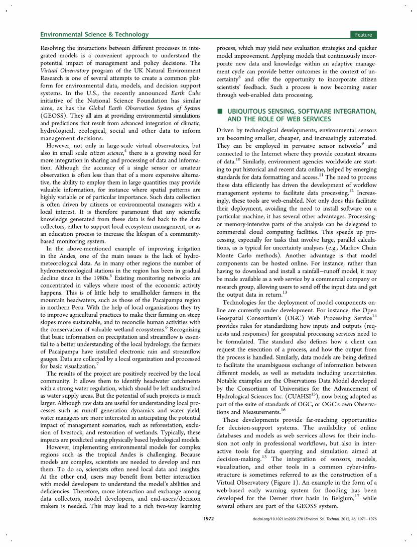
These developments provide far-reaching opportunitiesfor decision-support systems. The availability of onlinedatabases and models as web services allows for their inclu-sion not only in professional workflows, but also in inter-active tools for data querying and simulation aimed atdecision-making.13 The integration of sensors, models,visualization, and other tools in a common cyber-infra-structure is sometimes referred to as the construction of aVirtual Observatory (Figure 1). An example in the form of aweb-based early warning system for flooding has beendeveloped for the Demer river basin in Belgium,17 whileseveral others are part of the GEOSS system.
Environmental Science & Technology Feature
dx.doi.org/10.1021/es2031278 | Environ. Sci. Technol. 2012, 46, 1971−19761972
■ TOWARD INTERACTIVE AND OPENENVIRONMENTAL MANAGEMENT SYSTEMS
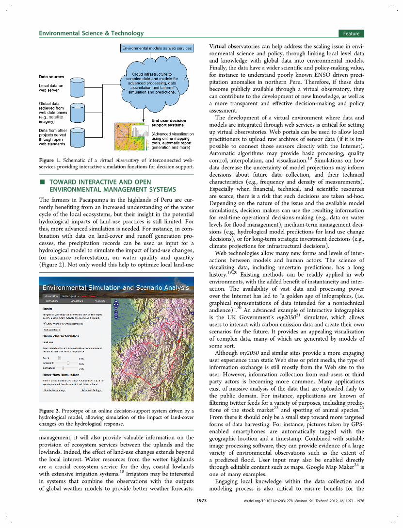
The farmers in Pacaipampa in the highlands of Peru are cur-rently benefiting from an increased understanding of the watercycle of the local ecosystems, but their insight in the potentialhydrological impacts of land-use practices is still limited. Forthis, more advanced simulation is needed. For instance, in com-bination with data on land-cover and runoff generation pro-cesses, the precipitation records can be used as input for ahydrological model to simulate the impact of land-use changes,for instance reforestation, on water quality and quantity(Figure 2). Not only would this help to optimize local land-use
management, it will also provide valuable information on theprovision of ecosystem services between the uplands and thelowlands. Indeed, the effect of land-use changes extends beyondthe local interest. Water resources from the wetter highlandsare a crucial ecosystem service for the dry, coastal lowlandswith extensive irrigation systems.18 Irrigators may be interestedin systems that combine the observations with the outputsof global weather models to provide better weather forecasts.
Virtual observatories can help address the scaling issue in envi-ronmental science and policy, through linking local level dataand knowledge with global data into environmental models.Finally, the data have a wider scientific and policy-making value,for instance to understand poorly known ENSO driven preci-pitation anomalies in northern Peru. Therefore, if these databecome publicly available through a virtual observatory, theycan contribute to the development of new knowledge, as well asa more transparent and effective decision-making and policyassessment.The development of a virtual environment where data and
models are integrated through web services is critical for settingup virtual observatories. Web portals can be used to allow localpractitioners to upload raw archives of sensor data (if it is im-possible to connect those sensors directly with the Internet).Automatic algorithms may provide basic processing, qualitycontrol, interpolation, and visualization.10 Simulations on howdata decrease the uncertainty of model projections may informdecisions about future data collection, and their technicalcharacteristics (e.g., frequency and density of measurements).Especially when financial, technical, and scientific resourcesare scarce, there is a risk that such decisions are taken ad-hoc.Depending on the nature of the issue and the available modelsimulations, decision makers can use the resulting informationfor real-time operational decisions-making (e.g., data on waterlevels for flood management), medium-term management deci-sions (e.g., hydrological model predictions for land use changedecisions), or for long-term strategic investment decisions (e.g.,climate projections for infrastructural decisions).Web technologies allow many new forms and levels of inter-
actions between models and human actors. The science ofvisualizing data, including uncertain predictions, has a longhistory.19,20 Existing methods can be readily applied in webenvironments, with the added benefit of instantaneity and inter-action. The availability of vast data and processing powerover the Internet has led to “a golden age of infographics, (i.e.graphical representations of data intended for a nontechnicalaudience)”.20 An advanced example of interactive infographicsis the UK Government’s my205021 simulator, which allowsusers to interact with carbon emission data and create their ownscenarios for the future. It provides an appealing visualizationof complex data, many of which are generated by models ofsome sort.Although my2050 and similar sites provide a more engaging
user experience than static Web sites or print media, the type ofinformation exchange is still mostly from the Web site to theuser. However, information collection from end-users or thirdparty actors is becoming more common. Many applicationsexist of massive analysis of the data that are uploaded daily tothe public domain. For instance, applications are known offiltering twitter feeds for a variety of purposes, including predic-tions of the stock market22 and spotting of animal species.23
From there it should only be a small step toward more targetedforms of data harvesting. For instance, pictures taken by GPS-enabled smartphones are automatically tagged with thegeographic location and a timestamp. Combined with suitableimage processing software, they can provide evidence of a largevariety of environmental observations such as the extent ofa predicted flood. User input may also be enabled directlythrough editable content such as maps. Google Map Maker24 isone of many examples.Engaging local knowledge within the data collection and
modeling process is also critical to ensure benefits for the
Figure 2. Prototype of an online decision-support system driven by ahydrological model, allowing simulation of the impact of land-coverchanges on the hydrological response.
Figure 1. Schematic of a virtual observatory of interconnected web-services providing interactive simulation functions for decision-support.
Environmental Science & Technology Feature
dx.doi.org/10.1021/es2031278 | Environ. Sci. Technol. 2012, 46, 1971−19761973
local population. To do so, participatory methodologies offeran opportunity to both gather information and validate modelsoutputs. Virtual observatories may then become tools to inte-grating formal-scientific knowledge with local-context specificobservations. Many types of social media are emerging that canenhance the interaction between both information streams. Forinstance, linking online simulation systems to voting systems asused in Facebook and Google+ allow users to express opinionsabout the quality of predictions, or the usefulness of these pre-dictions for their decisions. Uploaded photos and other evi-dence may be linked to specific news-items or applicationsfor easy identification. As another example, the use of specifickeywords known as hashtags has gained popularity on twitter asa way to “classify” messages and facilitate searching.The application of these technologies can be seen as an
extension of the experiment in radical scientific method of Laneet al.25 In this study, scientists met in person with members ofthe public to coproduce knowledge about flooding of Pickering,a small market town North Yorkshire, UK. Shared conceptualmodels, e.g., about peak attenuation and storm volume, playan important role in such joint knowledge generation. Althoughdirect, face-to-face meetings are probably the fastest way ofcoproducing knowledge, they are time-consuming and resource-intensive and hence they may be complemented by onlinetechnologies.Implementing environmental models in a web context may
thus bridge the gap between high-level environmental dataanalysis and the general public. Environmental models are per-fectly suited to function in a simulation environment, allowingfor “what if” scenario testing and “do-it-yourself” environmentaldecision-making, through web interfaces and even applicationson mobile phones. Especially in areas with low Internet pene-tration such as developing countries, the latter hold a strongpotential for information dissemination.All of this holds a promise of greater transparency and in-
clusive participation of citizens in environmental data collec-tion, modeling, research, and decision-making. Where conflict-ing recommendations in environmental policy discussionsresult from using different data sets and/or model implemen-tations in a nontransparent manner, virtual observatories mayhelp to avoid or more easily address these controversies.
■ POTENTIAL PITFALLS AND CHALLENGESIt is an aphorism that all models are wrong, though some maybe useful. Of course, uncertain environmental model results arealready heavily used in certain decision-making contexts, withthe climate change debate being a prominent example.26,27 Butopening up the access to new models for simulation purposesto a broader user community will present new challenges withregard to both characterizing uncertainties and to communicat-ing the meaning of simulations and the impact of assumptionsand errors.Especially when variable quality and informal data are used,
input errors in those data will propagate and may be amplifiedby errors and simplifications in the model structure. It willtherefore be essential to keep track of these errors when dataand simulations flow continuously among data sets, modelcomponents, and repositories across the web.On a more fundamental level, a lot of questions remain to be
solved about the way that model input uncertainties interactwith necessarily simplified and incomplete model structures.Uncertainties in measurements have been subject to a long his-tory of research, and are typically well represented by standard
statistical theory. However, uncertainties and errors in modelstructures may be epistemic rather than aleatory in natureand therefore much more difficult to fit in a classic statisticalframework.28
One challenge is of a technical nature. Interconnectingmodels and data sets into complex simulation systems will alsoallow errors in the data and the simulations to propagate.Quantifying these errors and tracking their propagation is es-sential. This is especially true when “new” data sources suchas citizen scientist’s measurements and expert knowledge arelinked into models. The development of markup languagesfor data exchange and their associated data models paysdue attention to the need for metadata including uncertain-ties (e.g., WaterML, CUAHSI, UncertWEB15,29−31), but theimplementation of these standards is still in its early stages.Many data sources that are currently available in the public do-main have no straightforward error model. In the case of citizenscientists or volunteer data collection, the collectors may nothave enough knowledge about the nature of the data to pro-perly characterize their uncertainties. Either automated or expert-assisted quality control systems will be needed. Such supportcould take the form of an online data input and storage applica-tion that facilitates the collection of metadata (e.g., a GPS-enabled mobile phone application that automatically stores thelocation of a data point), or runs a set of automated qualitycontrol routines before flagging any potential anomalies toexperts. Many data sets may need a model in itself to convertthe raw piece of information into useful data, as is already thecase for most satellite measurements (e.g., groundwater levelsderived from the GRACE satellite32).The use of qualitative data in environmental modeling is
yet more challenging. In hydrological modeling, a legacy of re-search exists on the use of nonformal performance measuresbased on expert opinions. This approach is pioneered by theGLUE methodology33 and explored widely thereafter, forinstance in the use of fuzzy logic34 and soft data for multicriteriamodel calibration.35 However, citizen science and social net-working may increase dramatically the amount of soft dataavailable for assimilation in models. Especially for the localrefinement of model strategies (as in the idea of models ofeverywhere36), expert opinions about model deficiencies andpathways for model improvement may be of particularimportance. New methods will have to be developed to collectand make optimal use of this information.Once the major sources of model uncertainties are quanti-
fied, communicating model performance and the impact ofsimplifications and assumptions presents another challenge.Users will want to evaluate whether models are fit for (their)purpose using a wide range and potentially idiosyncratic setof criteria.37 It is not uncommon that models fail to pro-duce useful data for policy comparison or good experimentalmanagement plans.37,38 Especially in decision-making processeswhere budgets are limited, interests need to be balanced. Wheresocietal perspectives on environmental issues vary widely,uncertainties can easily be used and misused to promote orchallenge particular policies.In this context the communication of the uncertainties, limi-
tations, and assumptions of models is of paramount impor-tance. This is perhaps most visible in the current climate changedebate, where the uncertainties and deficiencies of climatemodels and data are heavily scritinized by different actors. Forinstance, in the case of the climate skeptic network SurfaceStations, volunteers surveyed U.S. temperature station sites in
Environmental Science & Technology Feature
dx.doi.org/10.1021/es2031278 | Environ. Sci. Technol. 2012, 46, 1971−19761974
an attempt to identify errors in commonly used climate datasets.39 As a result, a lot of attention has been paid to developinga language and visualization techniques for uncertainties. (Foran overview see e.g., 20 and 27) Similarly, the meteorologicalcommunity has come a long way in quantifying and communi-cating uncertain weather forecasts to the general public.If environmental data and models are more open and easier
to access, it can therefore be expected that they will becomeincreasingly subject to scrutinization and debate too. It is there-fore essential that criteria be defined to assess the usefulness ofmodel predictions for specific applications, as well as ways tocommunicate them. This contrasts with the current tendency toassess models on a limited set of performance measures, as iscommon for instance in hydrological models.40,41 Rather, thediscipline of assessing the value of uncertain model predictionsin a decision-making context will need to be expanded,42 so thatit can contribute to the capacity of decision-makers to makeconvincing cases for their decisions without hiding the uncer-tainties, and to the capacity of citizens to accept the inevitableuncertainties surrounding any policy decision.Lastly, many environmental models themselves are currently
not designed to work in a flexible and adaptive web environ-ment, where the amount of data may be variable and the datathemselves may come in various flavors of quality, resolution,and spatial support. For instance, many hydrological models aremonolithic implementations of computer code43 with specificinput data that may not be available under all conditions. Ifmodels are to be applied in a demand-driven environment, theywill need to deal with a large variety of processes and data.Flexible model structures that adapt to data availability will beneeded, but have only recently been explored.36,44
The scientific issues of web-enabling models can only besolved when underpinned by adequate technical developments.Standardization of web protocols for data exchange and modelcoupling are under development, but run the risk of pooradoption, proliferation of standards, and resistance from inte-rest groups. There is an increasing awareness and interest amongdata providers to share data in the cloud. Especially govern-mental funding agencies such as the U.S. National ScienceFoundation and the UK Research Councils are encouraging oreven requiring research results to be made available in thepublic domain, and provide the necessary facilities (e.g., the UKCentre for Environmental Data Archival). However, other dataproviders may rely on the commercialization of generated datafor their business, while some data are restricted under govern-ment regulations. In these situations, authentication technolo-gies could enable restricted access, rather than having to disableaccess totally. For instance, the future CMIP5 repository of theBritish Atmospheric Data Centre is implementing an accesscontrol architecture for the OPeNDAP services standard.45
OPeNDAP and similar access protocols may also eliminate cur-rent problems with proliferation of file formats, such as GRIBand NetCDF. Even though the formats are documented, theirloose specification is often criticized as difficult to read andinterpret.We conclude that the unprecedented availability and access
to data through the Internet poses significant challenges toenvironmental scientists. Novel ways will have to be found tomanage and analyze these data and to generate informationrelevant for environmental management. New web technolo-gies provide exciting opportunities, both for processing infor-mation and for communicating to the end-user. Environmentalmodels, being primary tools to extract information from raw data,
will play a leading role in this process. Many challenges willneed to be addressed of how to design models, link them intonetworks, and let people interact with them. However, address-ing these has the potential to greatly increase the value of envi-ronmental modeling to manage natural resources and optimizetheir benefits for local livelihoods.
■ AUTHOR INFORMATIONCorresponding Author*E-mail: [email protected].
BiographyWouter Buytaert has a Ph.D. in Environmental Engineering from theUniversity of Leuven (2004), and is a lecturer in hydrology and waterresources at Imperial College London. His main research interest iswater resources and environmental change, with a focus on tropicaland subtropical regions. Selene Baez obtained her Ph.D. in Biologyfrom the University of New Mexico (2007), and is an AssociateResearcher at the Consortium for Sustainable Development for theNorthern Andes Ecoregion (CONDESAN). Her research interest is inthe interface of plant community ecology, global climate change, andhuman use of natural resources. Macarena Bustamante is an economistwith a Masters degree in Environment, Development and Policy at theUniversity of Sussex (2008). She investigates the role of institutionsand economic incentives to promote sustainable development in fragileenvironments subject to global environmental change. Currently, she isan Associate Researcher at CONDESAN. Art Dewulf received hisPh.D. in Organizational Psychology at the University of Leuven (2006).After a postdoc at Leuven, he started working as Assistant Professor atthe Public Administration and Policy Group in Wageningen University.Research themes include participatory technological innovation, adap-tive water management, and climate adaptation governance.
■ ACKNOWLEDGMENTSThe described case studies are funded by grant NE/I004017/1of the UK Natural Environment Research Council (NERC)held by W.B. Development of the Virtual Observatory tech-nology was supported by NERC contract NE/I00200/1. Wethank the three anonymous reviewers for their useful commentsand suggestions.
■ REFERENCES(1) Brugnach, M.; Tagg, A.; Keil, F.; de Lange, W. J. Uncertaintymatters: Computer models at the science-policy interface. WaterResour. Manage. 2007, 21, 1075−1090.(2) Ottinger, G. Buckets of Resistance: Standards and theEffectiveness of Citizen Science. Sci., Technol. Human Values 2010,35, 244−270.(3) Buytaert, W.; Cuesta-Camacho, F.; Tobon, C. Potential impactsof climate change on the environmental services of humid tropicalalpine regions. Global Ecol. Biogeogr. 2011, 20, 19−33.(4) Kolok, A. S.; Schoenfuss, H. L. Environmental Scientists,Biologically Active Compounds, and Sustainability: The Vital Rolefor Small-Scale Science. Environ. Sci. Technol. 2011, 45, 39−44.(5) Hannah, D. M.; Demuth, S.; van Lanen, H. A. J.; Looser, U.;Prudhomme, C.; Rees, G.; Stahl, K.; Tallaksen, L. M. Large-scale riverflow archives: importance, current status and future needs. Hydrol.Processes 2011, 25, 1191−1200.(6) Buytaert, W.; Celleri, R.; De Bievre, B.; Hofstede, R.; Cisneros,F.; Wyseure, G.; Deckers, J. Human impact on the hydrology of theAndean paramos. Earth-Sci. Rev. 2006, 79, 53−72.(7) De Bievre, B. Proceedings of the Conference on Global Change andthe World’s Mountains. Perth, September 28, 2010; Mountain ResearchInitiative, 2010.
Environmental Science & Technology Feature
dx.doi.org/10.1021/es2031278 | Environ. Sci. Technol. 2012, 46, 1971−19761975
(8) Schreiber, S.; Bearlin, A.; Nicol, S.; Todd, C. Adaptivemanagement: a synthesis of current understanding and effectiveapplication. Ecol. Manage. Restor. 2004, 5, 177.(9) Hart, J. K.; Martinez, K. Environmental Sensor Networks: Arevolution in the earth system science? Earth-Sci. Rev. 2006, 78, 177−191.(10) Williams, M.; Cornford, D.; Bastin, L.; Jones, R.; Parker, S.Automatic processing, quality assurance and serving of real-timeweather data. Comput. Geosci. 2011, 37, 353−362.(11) Uslander, T.; Jacques, P.; Simonis, I.; Watson, K. Designingenvironmental software applications based upon an open sensorservice architecture. Environ. Model. Software 2010, 25, 977−987.(12) Bajcsy, P. A Perspective on Cyberinfrastructure for WaterResearch Driven by Informatics Methodologies. Geogr. Compass 2008,2040−2061.(13) Goodall, J. L.; Robinson, B. F.; Castronova, A. M. Modelingwater resource systems using a service-oriented computing paradigm.Environ. Model. Software 2011, 573−582.(14) Schut, P. OpenGIS Web Processing Service 1.0.0. OpenGISstandard 05-007r7; 2007. http://www.opengeospatial.org/standards/wps, accessed August 1, 2011.(15) CUAHSI website. WaterOneFlow Web Services and WaterML.http://his.cuahsi.org/wofws.html, 2011.(16) Open Geospatial Consortium website. http://www.opengeospatial.org/standards/om, accessed August 3, 2011.(17) Schelfaut, K.; Pannemans, B.; Van Der Craats, I.; Krywkow, J.;Mysiak, J.; Cools, J. Bringing flood resilience into practice: theFREEMAN project. Environ. Sci. Policy 2011, 14, 825−833.(18) Buytaert, W. Climate Change & Water Resources. A GlobalVillage 2011, 5, 36−39.(19) Tufte, E. The Visual Display of Quantitative Information;Graphics Press: Cheshire, CT, 2001.(20) Spiegelhalter, D.; Pearson, M.; Short, I. Visualizing uncertaintyabout the future. Science 2011, 333, 1393−1400.(21) Department of Energy and Climate Change. http://my2050.decc.gov.uk/, accessed 19 December 2011.(22) Bollen, J.; Mao, H.; Zeng, X. Twitter mood predicts the stockmarket. J. Comput. Sci. 2011, 2, 1−8.(23) Fuka, M. Z.; Fuka, D. R. Methods for extracting climateindicator data from social media. Proceedings of the AGU GeneralMeeting, December 5−9 2011; San Francisco, 2011, H11B-1061.(24) Google Map Mapper. http://www.google.com/mapmaker,accessed December 20, 2011.(25) Lane, S. N.; Odoni, N.; LandstroIL, C; W., N.; Whatmor, S J;Bradley, S. Doing flood risk science differently: an experiment inradical scientific method. Trans. Inst. Br. Geogr. 2011, 36, 15−36.(26) Stainforth, D. A.; Downing, T. E.; Washington, R.; Lopez, A.;New, M. Issues in the interpretation of climate model ensembles toinform decisions. Philos. Trans. R. Soc., A 2007, 365, 2163−2177.(27) IPCC. Climate Change 2007 - Impacts, Adaptation andVulnerability; Cambridge University Press: Cambridge, 2007.(28) Beven, K.; Smith, P. J.; Woods, A. On the colour and spin ofepistemic error (and what we might do about it). Hydrol. Earth Syst.Sci. 2011, 15, 3123−3133.(29) Goodall, J. L.; Horsburgh, J. S.; Whiteaker, T. L.; Maidment,D. R.; Zaslavsky, I. A first approach to web services for the National WaterInformation System. Environ. Model. Software 2008, 23, 404−411.(30) Whiteaker, T.; To, E. CUAHSI Web Services for Ground WaterData Retrieval. Ground Water 2008, 46, 6−9.(31) Williams, M.; Cornford, D.; Bastin, L.; Pebesma, E. UncertaintyMarkup Language (UncertML); Technical Report, Aston University,Birmingham, UK, 2010.(32) Tapley, B. D.; Bettadpur, S.; Ries, J. C.; Thompson, P. F.;Watkins, M. GRACE Measurements of Mass Variability in the EarthSystem. Science 2011, 305, 503−505.(33) Beven, K.; Binley, A. The Future of Distributed Models: ModelCalibration and Uncertainty Prediction. Hydrol. Processes 1992, 6,279−298.(34) Freer, J.; McMillan, H.; McDonnell, J.; Beven, K. Constrainingdynamic TOPMODEL responses for imprecise water table information
using fuzzy rule based performance measures. J. Hydrol. 2004, 291,254−277.(35) Seibert, J.; McDonnell, J. On the dialog between experimentalistand modeler in catchment hydrology: Use of soft data for multicriteriamodel calibration. Water Resour. Res. 2002, 38, WR000978.(36) Beven, K. Towards integrated environmental models ofeverywhere: uncertainty, data and modelling as a learning process.Hydrol. Earth Syst. Sci. 2007, 11, 460−467.(37) Olsson, J. A.; Andersson, L. Possibilities and problems with theuse of models as a communication tool in water resource management.Water Resour. Manage. 2011, 21, 97−110.(38) Walters, C. Challenges in adaptive management of riparian andcoastal ecosystem. Conserv. Ecol. 2011, 1, 2.(39) Fall, S.; Watts, A.; Nielsen-Gammon, J.; Jones, E.; Niyogi, D.;Christy, J. R.; Pielke, R. A. Sr; Parodi, A.; Foufoula-Georgiou, E.;Emanuel, K. Analysis of the impacts of station exposure on the USHistorical Climatology Network temperatures and temperature trends.J. Geophys. Res. 2011, 116, D14120.(40) Schaefli, B.; Gupta, H. V. Do Nash values have value? Hydrol.Processes 2007, 21, 2075−2080.(41) Stedinger, J. R.; Vogel, R. M.; Lee, S. U.; Batchelder, R.Appraisal of the generalized likelihood uncertainty estimation (GLUE)method. Water Resour. Res. 2008, 44, W00B06.(42) Laio, F.; Tamea, S. Verification tools for probabilistic forecastsof continuous hydrological variables. Hydrol. Earth Syst. Sci. 2007, 11,1267−1277.(43) Buytaert, W.; Reusser, D.; Krause, S.; Renaud, J.-P. Why can’twe do better than Topmodel? Hydrol. Processes 2008, 22, 4175−4179.(44) Clark, M. P.; Slater, A. G.; Rupp, D. E.; Woods, R. A.; Vrugt,J. A.; Gupta, H. V.; Wagener, T.; Hay, L. E. Framework forUnderstanding Structural Errors (FUSE): A modular framework todiagnose differences between hydrological models. Water Resour. Res.2008, 44, W00B02.(45) Kershaw, P.; Ananthakrishnan, R.; Cinquini, L.; Lawrence, B.;Pascoe, S.; Siebenlist, F. A Flexible Component based Access ControlArchitecture for OPeNDAP Services. Geophys. Res. Abstr. 2010, 12,EGU2010−9289.
Environmental Science & Technology Feature
dx.doi.org/10.1021/es2031278 | Environ. Sci. Technol. 2012, 46, 1971−19761976