vulnerability, risk reduction, and adaptation to climate ... · droughts, floods, landslides,...
TRANSCRIPT

Yan
Oya
Yan
Oya
Mun
deni
Aru
Mad
uru
Oya
Aru
Aruvi
Jaffna
Negombo
Dambulla
Kalmunai
Dehiwala
Point Pedro
Trincomalee
Colombo Ratmalana
Colombo
Galle
Badulla
Puttalan
Ratnapura
Kandy
Jaffna
Negombo
Dambulla
Kalmunai
Dehiwala
Point Pedro
Trincomalee
Colombo Ratmalana
Colombo
Galle
Badulla
Puttalan
Ratnapura
Kandy
N
Kilometers
1000 5025
Key to Map SymbolsCapitalCity/TownMajor Road
River
Lake
Climate Risk and Adaptation Country Profile April 2011
CLIMATE
ADAPTATIONDISASTER
RISKREDUCTION SRI LANKA
Vulnerability, Risk Reduction, and Adaptation to
Climate Change
E N VTeam
Climate Change

2
Climate Risk and Adaptation Country Profile Sri Lanka
COUNTRY OVERVIEW
Sri Lanka lies between 6° and 10°N latitude and between 80° and 82°E longitude in the Indian Ocean, with a land area of nearly 65,610 square kilometers. The island consists of a mountainous area in the south-central part and a vast surrounding coastal plain.
1 The population is estimated to be 19 million and is projected to reach 23.1 million
by 2031. In 2006, the GDP was $26.9 million, with an annual growth rate of 7.3%.2
The climate of Sri Lanka is ideal for forest growth; the whole land area with a few exceptions was formerly covered with forests. Over the last century much of this forest cover, rich in biodiversity, has been destroyed, with less than one third of the area still under forest cover.
The economy is primarily driven by agriculture and the manufacturing sector.
3 Other key sectors that are important in the
context of climate change and disaster risk management include energy, water resources, public health, infrastructure (including that used by the manufacturing industry, and coastal ecosystems that support fisheries. In general, the coastal areas have better infrastructure and higher income. Coastal areas are important in meeting livelihood needs through agriculture and fisheries. As with many island nations, storm surges and coastal erosion are a problem. Changes in the frequency and intensity of extreme climatic events, sea level rise, and storm surges are the major concern for Sri Lanka.
4
These changes, along with the changes in forest cover and land use, are expected to further exacerbate the threats to the coastal areas
of Sri Lanka, the different sectors of the national economy, and human health.
PRIORITY ADAPTATION MEASURES
To address the critical issues of climate change and the impact on the environment and society, the Government of Sri Lanka, with active support from multilateral development agencies, is placing emphasis on adaptation measures targeted at key sectors. It has developed the National Climate Change Adaptation Strategy (NCCAS)
5 to
focus on both adaptation and disaster risk management. It recognizes the uncertainty of projected changes and impacts of climate change, but also accepts that adaptation and disaster risk management are imperative to ensure the country’s continued economic development and to minimize the risk to its gains in poverty reduction, food and water security, and public health. The NCCAS mirrors and supports Sri Lanka’s National Development Strategy. Five key areas are identified:
Mainstream Climate Change Adaptation into National Planning and Development: this includes cross-cutting policy measures, capacity building, safeguards, monitoring programs, and coordination mechanisms.
1 Sri Lanka National Communication to UNFCCC. 2World Bank Climate Change Knowledge Portal. 3Ibid. 4National Climate Change Adaptation Strategy for Sri Lanka 2011 to 2016 - http://www.adb.org/Documents/Produced-Under-TA/43173/43173-01-sri-dpta-07.pdf 5National Climate Change Adaptation Strategy for Sri Lanka 2011 to 2016
Key Sectors
Agriculture/Food Security
Energy
Coastal Zones and Marine Ecosystems (fisheries)
Water Resources
Health
Economic Infrastructure
Urban development
Source: Adaptation Learning Mechanism
3
Climate Risk and Adaptation Country Profile Sri Lanka
Enable Climate Resilient and Healthy Human Settlements: this includes housing, urban development and planning, public health, drainage, drinking water, urban wetlands, waste management, and pollution control.
Minimize Climate Change Impacts on Food Security: this includes agriculture, fisheries, irrigation, and nutrition.
Improve Climate Resilience of Key Economic Drivers: this includes tourism, transport, power generation, and commercial agriculture.
Safeguard Natural Resources and Biodiversity from Climate Change Impacts: this includes water resources management and biodiversity conservation.
Specific priority areas of action are identified under each of these categories. The need to strengthen national and local-level climate adaptation planning and implementation, stakeholder awareness and engagement for action and enhanced financing are themes highlighted in many of these key areas. The NCCAS also provides an extensive list of projects that could be developed, with different line ministries and agencies leading the effort.
CLIMATE BASELINE AND CLIMATE FUTURE
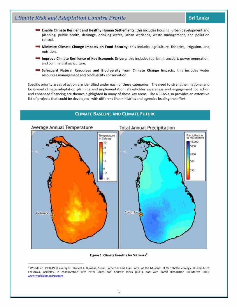
Figure 1: Climate baseline for Sri Lanka6
6 WorldClim 1960-1990 averages. Robert J. Hijmans, Susan Cameron, and Juan Parra, at the Museum of Vertebrate Zoology, University of
California, Berkeley, in collaboration with Peter Jones and Andrew Jarvis (CIAT), and with Karen Richardson (Rainforest CRC). www.worldclim.org/current
4
Climate Risk and Adaptation Country Profile Sri Lanka
CLIMATE BASELINE
Major Climate Processes
Impacts on Climate
El Niño
Warmer and drier than average conditions
La Niña
Cold and wet conditions Inter-Tropical Convergence Zone (ITCZ)
Drives rainfall
Surface temperatures in the Indian Ocean
Sri Lanka is hot and humid with significant variation in climate over time and space. This variation is reinforced by the country’s topography, which creates its unique rainfall pattern. The average annual rainfall in Sri Lanka varies from less than 1000 mm in the semi-arid area of the north-west and south-east of the island to above 5000 mm on the south-western slopes of the central hills. The country has four major rainfall seasons:
The south-west monsoon period (May to September) accounts for up to 55% of the annual precipitation and often exceeds 3000 mm of rain.
The inter-monsoon period (October to November) follows the south-west monsoon and contributes over 500 mm of rain in many places.
The north-east monsoon period (December to February) contributes about 200 mm to 1200 mm of rain.
The inter-monsoon period (March to April) follows the north-east monsoon.
Based on precipitation patterns, Sri Lanka is divided into three zones: Wet Zone, Intermediate Zone, and Dry Zone. The Wet Zone receives a mean annual rainfall of over 2500 mm, the Dry Zone receives less than 1750 mm, and the Intermediate Zone receives between 1750 mm and 2500 mm. Little or no seasonal annual variation of temperature is experienced in Sri Lanka, with mean annual temperature in coastal areas ranging from 26.0ºC to 28.0ºC. At higher altitudes, above 1500 m, temperature ranges between 15 ºC and 19ºC. Sri Lanka has a strong hourly variation in the mean temperatures throughout the year. The diurnal difference of temperature is obvious and its extent depends on the season, with a steady rise in the range based on altitude and distance from the sea.
7
Climate variability and change already strongly influence activities across Sri Lanka. The following is a summary of recent climate trends for the country (1961-1990):
8
General increasing temperature trend by 0.16˚C per decade; with the highest increase of minimum temperature around 2.0˚C at Nuwara Eliya.
Noticeable decreasing trend in rainfall pattern in most of the island with the exception of the north-east. Mean annual precipitation decreased by 144 mm (7%) compared to the period 1931-1960.
CLIMATE FUTURE
The climate science community sources a suite of models to inform decision makers on future climate. GCMs (Global Climate Models), RCMs (Regional Climate Models), downscaling techniques (both empirical and statistical), and several comprehensive reviews are available on the subject. GCMs are our primary source of information about future climate. They comprise simplified but systematically rigorous interacting mathematical descriptions of important physical and chemical processes governing climate, including the role of the atmosphere, land, oceans, and biological processes. The following insights into a changing climate are derived from a suite of GCMs used by the Intergovernmental Panel on Climate Change:
9
7 SRI Lanka National Communication to the UNFCCC 8 Sri Lanka National Communication to the UNFCCC 9The World Bank’s Climate Change Data Portal based on the IPCC GCMs for Colombo

5
Climate Risk and Adaptation Country Profile Sri Lanka
Mean annual temperatures are projected to increase by 1.0˚C. Mean rainfall is projected to change by 4%, with almost all models showing a decrease compared to historical records, with accompanying changes in the quantity and spatial distribution of rainfall.
10
Projections of future rainfall are less reliable under Global Circulation Models (Figure 2) for island nations (in part due to their coarse spatial resolution, which fails to capture local processes driving rainfall dynamics such as feedbacks and convection). What is clear, however, is that climate variability and extreme events across Sri Lanka will increase in the future.
Figure 2: Projected Changes in Rainfall for 2020-2039 as compared to between 1980-1999
10 Chandrapala, L. 1996b. Long term trends of rainfall and temperature in Sri Lanka. In: Climate Variability and Agriculture, Abrol, Y. P.; Gadgil, S.; Pant, G. B. (eds). New Delhi, India, Narosa Publishing House.
6
Climate Risk and Adaptation Country Profile Sri Lanka
CLIMATE CHANGE IMPACTS ON NATURAL HAZARD VULNERABILITY
The most frequent natural hazards that affect Sri Lanka are droughts, floods, landslides, cyclones, and coastal erosion. A rise in extreme events and natural disasters as a result of climate change is expected to pose considerable threat to Sri Lanka’s economy and human health.
11 The impacts of these
hazards across Sri Lanka are summarized below:
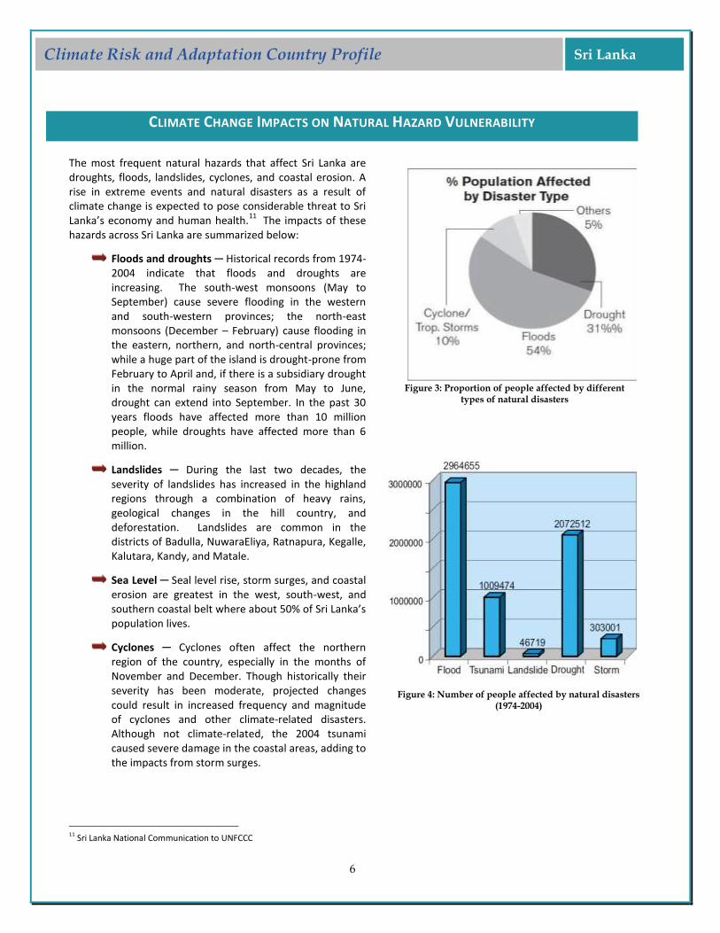
Floods and droughts ─ Historical records from 1974-2004 indicate that floods and droughts are increasing. The south-west monsoons (May to September) cause severe flooding in the western and south-western provinces; the north-east monsoons (December – February) cause flooding in the eastern, northern, and north-central provinces; while a huge part of the island is drought-prone from February to April and, if there is a subsidiary drought in the normal rainy season from May to June, drought can extend into September. In the past 30 years floods have affected more than 10 million people, while droughts have affected more than 6 million.
Landslides ─ During the last two decades, the severity of landslides has increased in the highland regions through a combination of heavy rains, geological changes in the hill country, and deforestation. Landslides are common in the districts of Badulla, NuwaraEliya, Ratnapura, Kegalle, Kalutara, Kandy, and Matale.
Sea Level ─ Seal level rise, storm surges, and coastal erosion are greatest in the west, south-west, and southern coastal belt where about 50% of Sri Lanka’s population lives.
Cyclones ─ Cyclones often affect the northern region of the country, especially in the months of November and December. Though historically their severity has been moderate, projected changes could result in increased frequency and magnitude of cyclones and other climate-related disasters. Although not climate-related, the 2004 tsunami caused severe damage in the coastal areas, adding to the impacts from storm surges.
11 Sri Lanka National Communication to UNFCCC
Figure 3: Proportion of people affected by different
types of natural disasters
Figure 4: Number of people affected by natural disasters (1974-2004)
7
Climate Risk and Adaptation Country Profile Sri Lanka
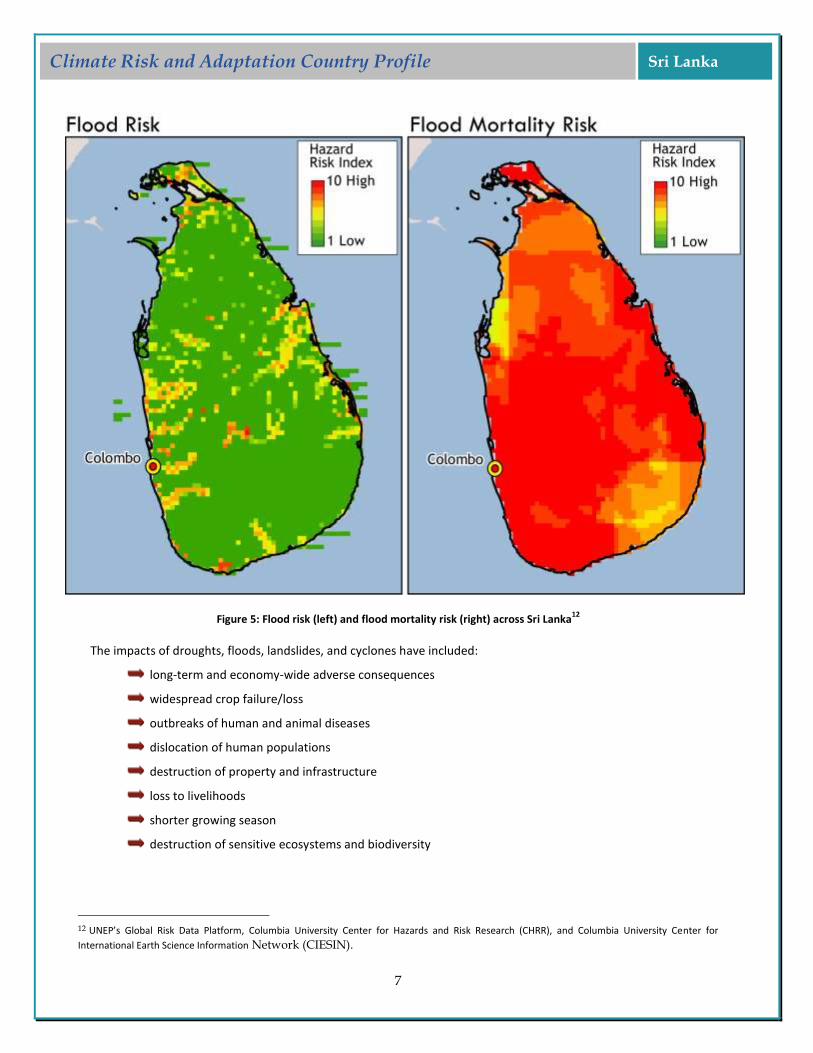
Figure 5: Flood risk (left) and flood mortality risk (right) across Sri Lanka
12
The impacts of droughts, floods, landslides, and cyclones have included:
long-term and economy-wide adverse consequences
widespread crop failure/loss
outbreaks of human and animal diseases
dislocation of human populations
destruction of property and infrastructure
loss to livelihoods
shorter growing season
destruction of sensitive ecosystems and biodiversity
12 UNEP’s Global Risk Data Platform, Columbia University Center for Hazards and Risk Research (CHRR), and Columbia University Center for
International Earth Science Information Network (CIESIN).

8
Climate Risk and Adaptation Country Profile Sri Lanka
SECTORAL CLIMATE RISK REDUCTION RECOMMENDATIONS
AGRICULTURE
The agricultural sector encompasses two sub-sectors: the domestic market and the export market. Rice is the major food crop grown in Sri Lanka, with cultivation limited to two major seasons ─ Yala and Maha. Available data (1970s to 1980s) shows that about two-thirds of the agricultural land where rice is grown is under irrigation, often from “tanks” (or shallow-water and relatively small reservoirs), and about a third is rain-fed. However, food crops such as pulses, oil crops, fiber crops, other cereals, yams, vegetables, etc. are also grown as a rotation crop, for household use, or for local markets.
The agriculture and forestry sectors rely on both traditional and modern technologies; generally neither sector is highly mechanized. Agroforestry is a common practice. Based on projected changes in climate, the direct and indirect impacts on both of these sectors are likely to be adverse. Since agriculture is the main source of livelihood for the majority of the rural population in the country, the socioeconomic impacts are thus likely to be large.
Key impacts include: Increasing demands on freshwater resources due to expanding human settlements, combined with impacts of droughts and saline water intrusion in the coastal areas, are likely to reduce water availability and affect both irrigated and rain-fed agriculture.
Variability and unpredictability of rainfall is likely to mean large fluctuations in agricultural yields, particularly for crops with defined growing seasons, such as rice.
Droughts and increased soil erosion, caused by both deforestation and heavy rainfall events, are likely to reduce storage capacity in tanks and associated canals. The storage capacity in tanks and canals is already affected by low maintenance and the impacts of climate change are likely to exacerbate this further.
13 Sri Lanka GFDRR 14 Sri Lanka National Communication for UNFCCC
Implications for Disaster Risk Management
Increased frequency and intensity of natural hazards such as droughts, floods, and landslides is causing damage to infrastructure, crops, and livelihoods.
Vector-borne diseases are spreading at an alarming rate, as a result of a changing climate conducive to mosquito breeding.
Vulnerable communities living along canals in specific districts are suffering from deteriorating conditions, especially when there is lack of risk preparedness, canal management and waste disposal programs, and early warning systems for flooding.
Increased rainfall intensity and forest cover reduction have led to increases in landslides, which result in greater displacement, loss of life, and heavy economic loss.
13
Sea level rise leads to inundation of low-lying coastal areas, shoreline retreat, intrusion of salinity, and negative impacts on coastal habitats. In addition, an increase in wave height will mean disturbing equilibrium beaches and making them more prone to erosion, while interfering with existing long shore sediment transport rates.
14

9
Climate Risk and Adaptation Country Profile Sri Lanka
WATER RESOURCES
Sri Lanka is exposed to moisture-laden winds from the south-west and the north-east. The geographical topography of the country (the highland massif) is a major determinant of water resources of the island in the south central region as is its location across the passage of monsoonal winds. These moisture-laden monsoonal winds are intercepted by the hills in the central region leading to a unique rainfall pattern. Despite its favorable geographic position, the country has widespread areas of water scarcity. A large part of the country experiences intermittent droughts, sometimes extending over several months. On the other hand, the coastal areas often get inundated by flood-waters from highlands.
Surface water from the high watersheds is transported by 103 distinct natural river basins that cover 90% of the island; the remaining 94 small coastal basins contribute only marginally to water resources. River basins originating in the wetter parts of the hill country are perennial, while the majority of those in the dry zone are seasonal. Surface water is estimated to vary from 4.0 to 5.13 million cubic meters annually. Much of it is used for hydropower generation and irrigation and the balance is discharged to the sea. Over 60% of the water that is discharged comes from the wet zone and often leads to floods and water-logged lowlands.
Water resources in Sri Lanka are critical for many development sectors and for human use. As with agriculture, the overall impacts of climate change are likely to be adverse, thus affecting agriculture, energy generation, human health, and human settlements. The Water Resources Board Act No.29 of 1994 provides for integrated planning and conservation of water resources, the coordination of river basin management and monitoring, and other measures to effectively manage and regulate economic uses of water. This Act would be a good basis for managing the impacts of climate change on this critical sector.
COASTAL AND MARINE ECOSYSTEMS
The Coast Conservation Act covers the coastal zone based on geo-physical considerations, using linear dimensions. This narrow and geographically defined coastal zone does not recognize the interconnectedness of coastal ecosystems, its resources, and human activities. The limited definition of the coastal zone hence represents a critical constraint when implementing action plans to respond to impacts of climate change, especially storm surges, sea level rise, and coastal erosion.
Based on this definition, Sri Lanka’s coastal zone management could exclude the following: Approximately 24% of the land area (including 65% of the urbanized land area) and 32% of the population
Principal road and rail transport infrastructure, commercial ports, fishery harbors, and anchorages
65% of industrial output
80% of tourism-related infrastructure, the majority of which is located in the western and south-western coastal regions in close proximity to the shoreline
80% of fish production
A significant portion of agricultural land and substantial mineral reserves
Some of the richest areas of biodiversity, including coral reefs, seagrass beds, mangroves, lagoons, estuaries, wetlands, and sanctuaries covering large undeveloped areas
Many areas of cultural, historical, and religious significance as well as scenic beauty
The combined effects of an increased mean sea level rise, increased wave heights, and storm surges would adversely impact coastal structures, increase coastal erosion, and alter circulation patterns within bays and estuaries, leading to inundation of coastal settlement, destruction of coral reefs, and wetlands. These would have further adverse impacts on the economy and human population that depends on coastal resources. In addition,
10
Climate Risk and Adaptation Country Profile Sri Lanka
some of the most critical transportation infrastructure runs along coastal areas that are already being impacted by erosion, so changes to climate are likely to add to these adverse impacts.
ENERGY
The main fuels used for power generation in Sri Lanka are furnace oil, residual fuel oil, and diesel but the major source of energy is hydropower. Given the impact of climate change on water resources, the impact on the energy sector is thus both direct and indirect.
The design of hydropower reservoirs is based on historical data and the potential impacts of prolonged droughts and change in the intensity of rainfall events are likely to lead to their underperformance. This in turn will reduce power generation capacity, limiting the ability to ensure continuous power supply to the country’s population and to serve its economic needs. Prolonged droughts will also likely affect the cooling water supplies to thermal plants, resulting in further reduction in operational capacity. New designs that include cooling towers for such plants are expensive to install and operate and thus would further impact the country’s economy.
Projected increases in the intensity of heavy rainfall events are likely to affect the reservoir structures, which are designed for historical rainfall. Additional impacts could be downstream flooding as a result of the necessity for water regulation in the reservoirs. Projected increases in temperature are likely to result in a higher rate of water evaporation from the reservoirs, thus reducing available reserves for power generation.
It will be necessary to address the complex and interconnected issues related to water resources, meeting the irrigation, power generation, and human consumption needs. Complex decisions and tradeoffs are likely to be a major aspect of water management in the future under increasing climate change impact.
HUMAN SETTLEMENTS
Human settlements in Sri Lanka are distributed throughout the island except in protected areas such as forest reserves and wildlife reserves. Climate-related impacts on human settlements include:
Increased frequency and intensity of floods and landslides causing extensive asset damage/loss and displacement of people, particularly the poor.
Increased frequency and intensity of droughts exerting greater pressure on freshwater resources and making drinking water shortages more frequent and severe, particularly in the Dry and Intermediate Zones.
Increases in ambient temperatures resulting in greater energy (electricity) demand for cooling purposes among the affluent portion of the population.
Increases in vector densities, resulting in the rapid spread of diseases such as dengue, particularly in urban areas.
Gradual sea level rise and associated effects causing long-term damage to coastal settlements, infrastructure, and livelihoods.
Increased water scarcity and/or reduced water quality from saline water intrusion in coastal areas, where the majority of the population lives.
Human settlements on the island fall into five categories based on their level of vulnerability:
Settlements located within the 1 m mean sea level contour and settlements encroaching on 50- and 1000year flood plains ─ These include substantial areas of squatter settlements and low income housing.
Settlements on landslide-prone areas and settlements on steep erodible slopes ─ These also include substantial squatter settlements and low income housing.
11
Climate Risk and Adaptation Country Profile Sri Lanka
Settlements in cyclone-prone areas; settlements in drought-prone areas, and settlements dependent on subsistence-type rain-fed agriculture and on commercial fishing.
Settlements in or close to forest-fire-prone areas and settlements in storm-, lightning-, and wind-prone areas.
Settlements that are dependent on irrigation schemes for their income or livelihoods.
Detailed assessment and mapping is needed to better determine the vulnerability of human settlements and manage the potential impacts of climate change.
TRANSPORT
The transport sector includes both domestic and international transport and is mainly dependent on gasoline and diesel. Each of these sectors could be further subdivided into passenger transport and freight transport. The domestic passenger transport consists of individual transport such as cars, vans, light duty vehicles, and motorcycles, while public transport comprises mainly buses and railways. Domestic freight movement hinges mainly on road and rail; the extent of coastal shipping is relatively small. The road freight transport fleet consists of trucks. International transport comprises both air and sea transport. Air transport handles nearly all of the passenger transport and a relatively small amount of freight; sea transport handles the bulk of the freight dealing with imports and exports. A small amount of sea freight includes transport to the northern and eastern regions of the country.
Sri Lanka has extensive bitumen-surfaced roads, especially around the coast, low-lying areas, and to major tourist destinations. It also has railway track, most of which is limited to a single line and the port of Colombo, which is the main marine center for navigation in Sri Lanka and handles most of the international marine transport. Given its location, transport infrastructure is highly vulnerable to climate change impacts through storm surges and slow sea level rise, droughts and high-intensity rain, particularly because a considerable length of the major road and railway network runs along the coast and in low-lying areas.
INDUSTRY
Industry is often subdivided into three sub-sectors, i.e. factory industry, processing of plantation crops and small industries. These sectors contributes about a fifth of GNP with the factory industry (e.g. clothes manufacturing) contributing about 80% of the value-added. While some of the industries are local market-focused, others are export-oriented and are concentrated near Colombo, because of the availability of relatively better infrastructure and the proximity to the harbor and the airport. Again the coastal and low-lying location means they are likely to be adversely impacted by climate change and climatic extremes. Industry is also likely to be further affected through impacts on water and energy.
HEALTH
The impacts of climate change on human health are likely to be both direct and indirect. The direct effects result from changes in climate characteristics or short-term weather extremes that impinge directly on human biology. The indirect effects are those that do not entail a direct, causal connection between a climatic factor (such as heat, humidity, or extreme weather event) and human biology.
During drought periods, water scarcity affects human health. The scarcity of water for drinking, washing, and cooking affects the population not only directly, (e.g., consumption and hygiene), but also indirectly by increasing the incidence of water-borne diseases, such as diarrhea, due to poor water quality. Increased rainfall intensity is also likely to affect human health indirectly by damaging structures and houses, and by inundating roads and compounds.

12
Climate Risk and Adaptation Country Profile Sri Lanka
With the projected changes in temperature and rainfall, there are likely to be changes in malaria transmission zone to areas that are currently free from malaria. The seasonal pattern of malaria transmission is likely to undergo a change, with the high transmission season (currently November-February) being shortened and the minor mid-year peak season being enhanced, with high rates of transmission occurring in September. This could also impact the tourism industry.
The projected increases in water scarcity, vector-borne diseases, and, and excessive heat (which can cause disorders such as heat cramps, dehydration, rashes (prickly heat) and heat edema leading to dehydration and electrolyte imbalance over the long term) mean that the poor, the aged, those involved in outdoor activity, workers in ‘hot’ working environments and pregnant women in the first trimester will face greater risks.
ADAPTATION
Adaptation options need to address multiple stresses as climate change does not work in isolation and is often an added stress. Hence the Government of Sri Lanka’s link of adaptation to development strategy is an excellent start to addressing multiple stresses. The NCCAS has listed a large number of adaptation options for each of the key sectors.
Sectors Adaptation Options
Agriculture/Food Security
Educational and outreach activities to change management practices to those suited to a changing and more variable climate. Extend agroforestry especially in uplands to increase climate resiliency, provide different sources of income, and reduce land erosion, especially in uplands and with very steep slopes.
Enhance irrigation efficiency and/or expand irrigation, although this could be a challenge in areas that are affected by intermittent droughts.
Promote conservation farming techniques in areas vulnerable to soil erosion.
Make farmers aware of climate change and inform them about different adaptation options including showcasing through “demonstration farms”.
Increase productivity in the plantation and minor export crop sectors, and diversify agricultural production and food crop choices.
Develop drought-resistant and, if possible, fast-growing rice varieties to reduce the risk of yield losses from variable and unpredictable rains.
Change land use patterns in landslide-prone areas and other vulnerable areas and discourage settlement in such areas.
Increase agricultural productivity by introducing improved varieties and improved management practices.
Introduce and promote water harvesting techniques.
Water Resources
Encourage minor storage reservoirs and promote participatory micro-watershed management.
Decrease water demands, e.g. by increasing efficiency, reducing water losses, water recycling, changing irrigation practices.
Increase water supply, e.g. by using groundwater, building reservoirs, improving or stabilizing watershed management, desalination.
Investigate feasibility of trans-basin diversion schemes to counter climate change impacts.
Explore possibility of re-distribution of population and major changes in land use planning.

13
Climate Risk and Adaptation Country Profile Sri Lanka
Conserve in-situ seasonal water bodies that have valuable biological resources
Introduce permits for water use and instigate water monitoring, including with the involvement of communities.
Rehabilitate irrigation water tank networks in dry and intermediate zones.
Develop and introduce flood and drought monitoring and control systems.
Improve maintenance of existing tanks and reservoirs, including their watersheds and catchments.
Coastal Zones and Marine Ecosystems
Delineate critical areas and prepare/develop a special Integrated Coastal Zone Management plan.
Develop planning/new investment requirements.
Incorporate climate change concerns in wetland conservation programs.
Accommodate sea level rise and storm surges in the design of new coastal structure.
Formulate coastal database for implementing integrated coastal area management.
Monitor meteorological parameters in all coastal districts.
Incorporate greater consideration of climate change impacts in the next revision of the Coastal Zone Management Plan (CZMP).
Energy and Industry
Adopt loss-reduction measures at generation, transmission, and distribution levels.
Promote renewable energy technologies in place of fossil-fuel-fired plants wherever they are technologically and economically feasible; local and low cost technologies for rural areas.
Encourage energy conservation through consumer education in industrial, commercial, and domestic sector.
Increase the use of biogas technologies, especially in rural areas.
Encourage the manufacturing sector to replace high energy consuming equipment with modern energy-efficient devices.
Prepare baseline maps of disaster risk areas for specific extreme weather events.
Health /Safety
Develop early warning systems (using, for instance, GIS techniques) for monitoring of natural disasters.
Upgrade health facilities in vulnerable areas, especially remote areas with difficult terrain and limited transport.
Formulate and enforce regulations to building design (public/private, households) to withstand/minimize structural damage and injury to people.
Motivate people to accept and heed safety measures at individual household level by providing (a) free engineering/architectural advice and consultations and (b) soft loans for alterations to dwellings.
Relocate people from vulnerable locations.
Develop and establish RS/GIS/early warning systems in vulnerable areas.
Public Policy
Integrate suitable adaptation measures into all urban development plans.
Prepare and update national disaster management plan with adequate coverage on climate change.
Integrate climate change concerns/responses in relevant national policies.
Transport
Improve road/railway infrastructure design standards to incorporate climate change considerations.
14
Climate Risk and Adaptation Country Profile Sri Lanka
EXISTING ADAPTATION FRAMEWORK/STRATEGY/POLICY AND INSTITUTIONAL SETUP
In light of the increasing impact of climate change and the need for future preparedness, the Ministry of Disaster Management and Human Rights (as the leading ministry) and the Disaster Management Center (DMC) (as the national level nodal agency) have been tasked with formulating national and local-level disaster risk management programs and aligning them with sectoral development programs. In addition, an intra-government network has been established with assistance from JICA to connect the Irrigation Department, NBRO, the Meteorological Department, DMC, Police communications, Media networks and 7 district offices most vulnerable to disasters. The plan is for this network to facilitate sharing of GIS maps and other data to better coordinate and manage response activities.
15
Ongoing Efforts- At a Glance
Vulnerability Reduction Agency or Donor
Ensure that disaster risk reduction is a national and local priority with a strong institutional basis for implementation DMC, NCDM ,WB, GFDRR
Identify, assess, and monitor disaster risks – and enhance early warning UNDP, DMC
Reduce the underlying risk factors Met agency, CBO
Use knowledge, innovation, and education to build a culture of safety and resilience at all levels Ministry of Education, Ministry of DM&HR, German Development Corporation
GFDRR Interventions Agency or Donor
Improving Sri Lanka’s response and recovery in the aftermath of natural disasters, including supporting the preparatory steps for implementation of the Disaster Management Fund Ministry of DM&HR, UNDP
Institutional strengthening and building of technical expertise NBRO
Flood Management Project - GAMPAHA District JICA,DMC
Landslide anagement Pro ect Nuwara Eliya District
RESEARCH, DATA, AND INFORMATION GAPS
The major gaps associated with the existing initiatives include inability to have experts on a full-time basis, limited accessibility to specific studies, data, information and relevant research, and inadequate time available for undertaking specific studies and research on impacts of climate change. The major needs include the assessment of vulnerability of the different sectors to climate change impacts, adaptation of measures to reduce GHG emissions in the industrial, transport, and agricultural sectors, and implementation of adaptation measures that have already been identified.
RESEARCH GAPS
Coastal Zone – Research on the influence of increased salt water intrusion in selected river estuaries and general vulnerability of coastal areas. Studies of impacts of sea level rise, storm surges, and temperature rise on coral reef systems in polluted and non-polluted parts of the coast.
15 GFDRR: Country Programs for Disaster Risk Management and Climate Adaptation http://www.gfdrr.org/gfdrr/node/112

15
Climate Risk and Adaptation Country Profile Sri Lanka
Water Resources –Research and hydraulic monitoring of the extent of intrusion of salinity wedge along waterways for different scenarios of sea level rise and the impact of climate variability and climate change on river flow regimes.
Health - Studies on epidemiological forecasting and early warning systems using RS/GIS technology in high risk areas for malaria, dengue, Japanese encephalitis, diarrheal disease, and nutritional disorders. Prospective and retrospective studies on identified disease patterns such as eye and skin disorders relevant to climatic change in specific areas.
Human Settlements ─ Studies of the impact of climate change and disaster risk on existing infrastructure, such as sewerage and drainage systems and urban water supply schemes, including reservoirs. Developing storm-, wind-, and cyclone-resistant building standards and guidelines for different building categories (NBRO, CHPB, ICTAD, BD, NERD, SLT, CEB).
Agriculture ─ Research on new methods to improve water use in agriculture, how to enhance the adoption of such knowledge, and use new cultivars and improved seeds, especially in those regions that are currently facing water deficits during the dry seasons.
16
DATA AND INFORMATION GAPS
Overall lack of necessary data and information as well as technical support in the development of disaster management database and risk and hazard mapping.
17
Coastal Zone ─ Preparation of a coastal database at a suitable resolution and linking it with an appropriate environmental monitoring system.
Agriculture ─ Estimating the change in production rates of different crops – rice, field crops, vegetables, plantation crops - and identifying agro-ecological zones particularly sensitive to climate change impacts.
Water Resources ─ Documenting permit/monitoring systems for groundwater extraction and water quality assessment in vulnerable areas and assessing extent of land that will be affected by sea level raise.
Human Settlements ─ Collection of adequate data for managing and implementing early warning systems.
16 Sri Lanka National Communication to the UNFCCC 17 Sri Lanka GFDRR
SRI LANKA
Climate Risk and Adaptation Country Profile
GFDRR PriorityCountries
Acknowledgments: The Country Profiles were produced through a partnership between the Global Facility for Disaster Reduction and Re-covery and the Climate Change Team of the Environment Department of the World Bank, by a joint task team led by Milen Dyoulgerov (TTL), Ana Bucher (co-TTL), and Fernanda Zermoglio. Additional support was provided by Sarah Antos, Michael Swain, Carina Ba-chofen, Fareeha Iqbal, Iretomiwa Olatunji, Francesca Fusaro, Marilia Magalhaes, Habiba Gitay, and Laura-Susan Shuford. IT, GIS, and map production support was provided by Varuna Somaweera, Katie McWilliams, and Alex Stoicof from the Sustainable Development Network Information Systems Unit (SDNIS). Jim Cantrell provided design. The team is grateful for all comments and suggestions re-ceived from the regional and country specialists on disaster risk management and climate change.
E N VTeam
Climate Change
© 2011 THE WORLD BANK GROUP1818 H Street, NWWashington, DC 20433Internet: www.worldbank.orgContact: Milen Dyoulgerov, [email protected]
All rights reserved.
This volume is a product of the World Bank Group. The World Bank Group does not guarantee the accuracy of the data in-cluded in this work. The boundaries, colors, denominations, and other information shown on any map in this work do not imply any judgement on the part of the World Bank Group concerning the legal status of any territory or the endorsement or acceptance of such boundaries.
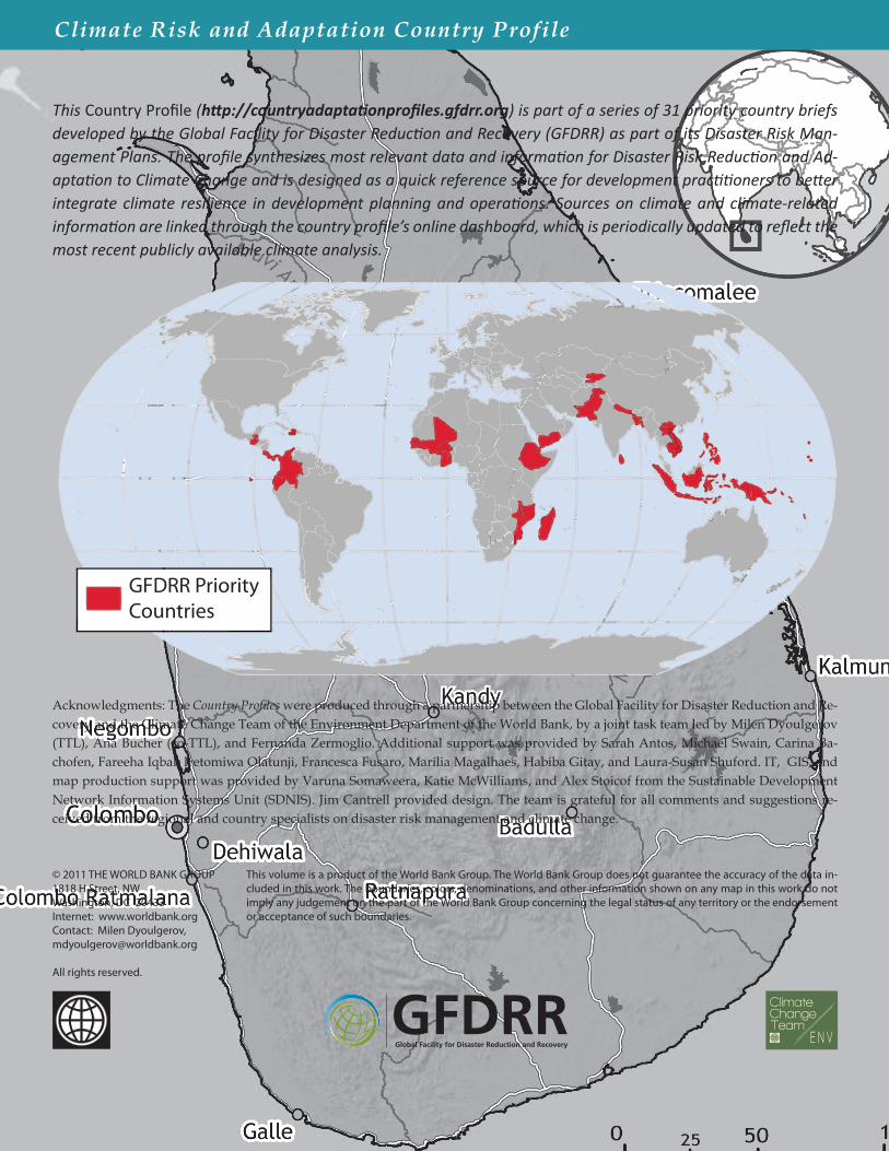
This Country Profile (http://countryadaptationprofiles.gfdrr.org) is part of a series of 31 priority country briefs developed by the Global Facility for Disaster Reduction and Recovery (GFDRR) as part of its Disaster Risk Man-agement Plans. The profile synthesizes most relevant data and information for Disaster Risk Reduction and Ad-aptation to Climate Change and is designed as a quick reference source for development practitioners to better integrate climate resilience in development planning and operations. Sources on climate and climate-related information are linked through the country profile’s online dashboard, which is periodically updated to reflect the most recent publicly available climate analysis.