volcano heights - cabq.gov heights sector... · the volcano heights (formerly “volcano cliffs”)...
TRANSCRIPT

VOLCANO HEIGHTS
PLANNING STUDY REPORT
******* March 15, 2005
Prepared for the City of Albuquerque


Prepared for the City of Albuquerque Mayor Martin J. Chavez James Lewis, Chief Administrative Officer Albuquerque City Councilors: Miguel A. Gomez, district 1 Debbie O’Malley, District 2 Eric Griego, District 3 Brad Winter, District 4, City Council President Michael J. Cadigan, District 5 Martin Heinrich, District 6 Sally Mayer, District 7 Craig Loy, District 8 Tina Cummins, District 9
By:
Shared Vision – Coordination & Urban Planning Jolene Wolfley – Local Planner
Catalyst – Urban Design & Landscape Architecture Dennis Town Planning
Freilich, Leitner & Carlisle – Land Use Law
Louis J. Colombo, City Council Deputy Director Joel Wooldridge, Albuquerque Planning Department

VOLCANO HEIGHTS PLANNING STUDY REPORT TABLE OF CONTENTS Page PURPOSE 1 I. Conditions, Trends and Issues 2 A. Description of Area 2 B. Development Trends 9 C. Land Use Plans and Policies 13
D. Major Issues 13 II. Planning Process 17 A.. Gathering Information 17
B. Three Land Use Alternatives 17 C. Workshops with Property Owners and Community 19 III. Workshop Results and Vision 21 IV. Concept Plan 26 A. Land Use 26
B. Open Space Network 29 Description and Recommendations Acquisitions C. Transit and Transportation 33 D. Development Character 34 Mixed-Use Town Center
Mixed-use Village Centers Urban Residential Neighborhoods Suburban Residential Neighborhoods Neighborhood Edge
V. Implementation Strategy 39
A. Overview 39 B. Implementation Strategies by Subareas 42 C. Timing and Phasing 47 APPENDICES 1 Applicable Plans and Policies 2 Rio Rancho Redevelopment Process 3 Invitees to Workshop 4 Open Space Acquisitions 5 Menu of Implementation Tools

VOLCANO HEIGHTS PLANNING STUDY REPORT EXHIBITS Reference Title Page 1 City Council Designated Plan Area 3 2 Jurisdictions, Parcels and Pipeline Projects 4 3 Aerial Context and Regional Circulation 5 4 Natural and Cultural Features 6 5 Zoning and Comprehensive Plan Designations 8 6 Transportation and Water Systems 10 7 Pipeline Projects 12 8 Comparison of Scenarios: Trend, Village and Town Center 18 9 Concept Plan 27 10 Open Space Network 30 11 Implementation Subareas 43 TABLES 1 Trend Scenario Assumptions 11 2 Employment Deficits under Different Scenarios 15 3 Statistical Summary of Concept Plan 29 4 Open Space Acquisitions 32 ILLUSTRATIONS 1 Mixed Use Town Center 34 2 Mixed-use Village Centers 35 3 Urban Residential Neighborhoods 36 4 Suburban Residential Neighborhoods 37 5 Neighborhood Edge 38


PURPOSE City Council Authorization On October 4, 2004 the City Council instituted a six-month moratorium on development in the Volcano Cliffs (now called “Volcano Heights”) area (R-04-145) and called for a planning study to be completed. The Council saw the need to develop a plan that would help to bring development in line with previously established policies. The Council Resolution found that “The Volcanic Escarpment of the Northwest Mesa has long been considered a unique landscape that requires special protection.” Given the development pressures the area is now experiencing, a plan guiding development in the area is long overdue. The goal of this process is a plan that results in more sustainable development benefiting property owners and the larger community. This planning study is intended to be the first step, providing a foundation and guidance on further detailed plans and implementation to follow. The planning team suggests re-naming the Plan Area to “Volcano Heights” to distinguish it from the small lot portion of the larger area and update the image. This report uses the Volcano Heights term throughout.
1

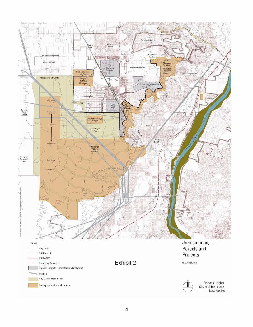
I. CONDITIONS, TRENDS AND ISSUES A. Description of Area The Volcano Heights (formerly “Volcano Cliffs”) Plan Area, as established by the City Council (See Exhibit 1) covers 3,420 acres. From east to west, the Plan Area extends from the volcanic escarpment, that has been the historic limit of Albuquerque’s western edge and is now part of the Petroglyph National Monument (the “Monument”) surrounding five dormant volcanoes. From north to south, the Plan Area extends from Paseo del Norte to city open space and the Monument. The area is surrounded on the three sides with approximately 7,000 acres of open space under city, state and federal jurisdictions. Citywide views The volcanoes, rising above the volcanic escarpment on the western horizon of Albuquerque, form a dramatic backdrop to the city much as the Sandia mountains do to the east. They are an important part of Albuquerque’s identity and a prominent natural feature framing the city. Exhibit 2 Jurisdictions, Parcels & Projects shows the relationship of the Plan Area to west side jurisdictions and development patterns. Exhibit 3 Aerial Context and Regional Circulation provides an overview of the existing and proposed transportation system overlaid on an aerial view of the Plan Area and surroundings. Natural and Cultural Features (See Exhibit 4 Natural and Cultural Features) The Volcano Heights Plan Area is part of the same rich landscape that includes the land the US Congress set aside as Petroglyph National Monument in 1990. The west mesa is the center of the Rio Grande rift. It emerged about 150,000 years ago when lava flowed from a large crack in the Earth's crust, creating the 17-mile long mesa. Eruptions continued forming the five cinder cones, or volcanoes, visible today. Over time, the mesa's eastern edge eroded, leaving an escarpment strewn with basalt boulders. Over the centuries, the quiet yet massive presence of the volcanoes attracted many groups of people to the area. The Native American presence dates back to the Ice Age 12,000 years ago. Archaeological sites with artifacts from these bison hunters were discovered in 1998 near the Northern Geologic Window. Additional Native American presence is associated with the petroglyphs. Some petroglyphs were created 3000 years ago, while the majority were created 700 years ago. Petroglyphs were pecked into the thin varnish on the basalt boulders at the eastern edge of the lava flow. There are 20,000 petroglyphs carved along the 17-mile escarpment canyon. The National Park Service ethnographic study from 2002 identifies the entire volcanic area as an important religious and cultural site for all the twenty contemporary Pueblo communities and also for contemporary Navajo and Apache communities. Many Pueblo Indians believe the volcanoes and the petroglyphs pecked into the volcanic boulders provide
2

Exhibit 1
3
4
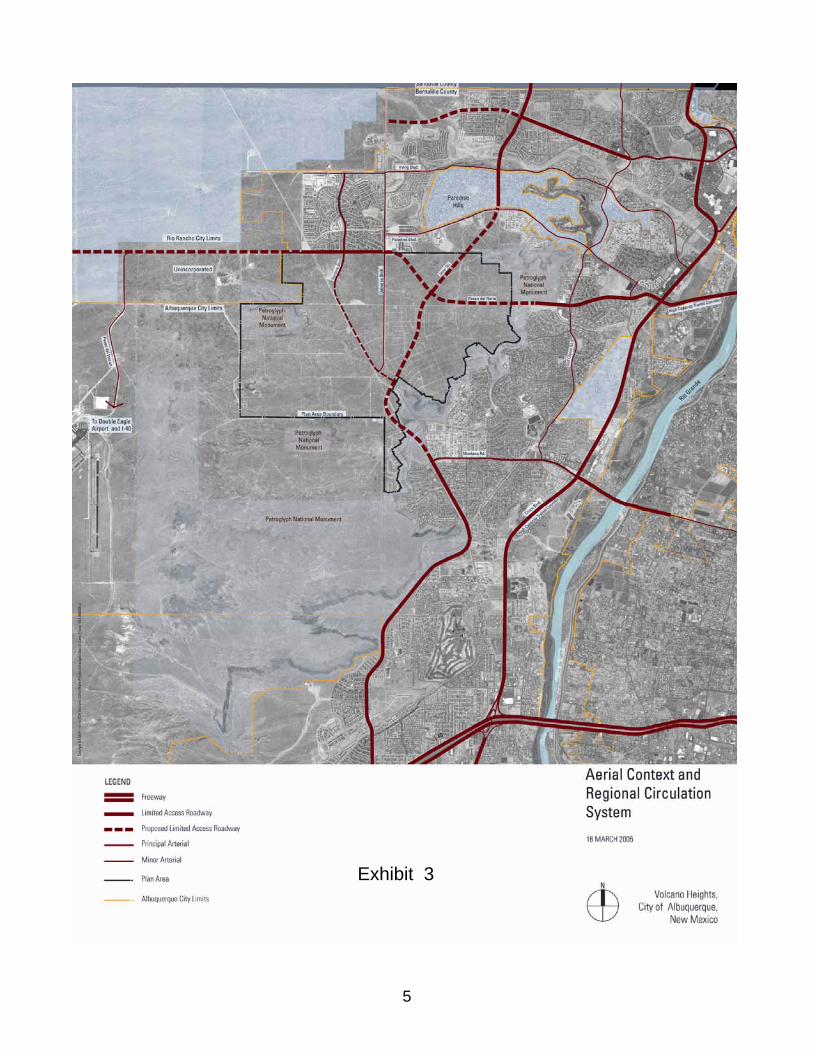
Exhibit 3
5

Exhibit 4
6

a direct spiritual connection to both their ancestors and to the spirit world. To them, it is a sanctified place imbued with spiritual qualities and powers. In the 1600s, Hispanic heirs of the Atrisco land grant herded sheep in this area. Their petroglyphs are mixed in with the Native American petroglyphs, but are distinguished by type, e.g., crosses and sheep brands. More traditional Native Americans and Atrisco land grant heirs continue to hold deep emotional ties to this land. For these Native Americans the area is a current cultural site, not just an historical one. While their physical use of the area has been limited by the subdivisions that wrap the bottom edge of the escarpment, Native American representatives assert that tribes continue to reference the area in their rituals. The Monument and affiliated city open space create a major natural ecosystem for Albuquerque. At the heart of the ecosystem are the Boca Negra/Mariposa arroyos, making up a 21 square-mile watershed. The watershed is generally bounded by the Calabacillas Arroyo basin on the north (roughly along Paseo del Norte corridor) and the San Antonio arroyo basin on the south (roughly along the Montano corridor). The watershed extends to a small area below the escarpment and into the Mariposa Detention Basin. Many past activities scarred the natural landscape before it was set aside as public open space. Some of the volcanoes were mined. The area was a bombing range during World Ward II. Later, electrical power lines and a gas pipeline were built across the area. Activities detrimental to the natural environment continue today, e.g., illegal dumping, off-road vehicles use, and target shooting. “There are five majestic volcanoes aligned in a straight row on the west side of present day Albuquerque. This area was recognized by our ancestors as an important place of worship, for five volcanoes in a straight row is not a commonplace occurrence.” - (William Weakhee, Executive Director for Sandoval Indian Pueblos, 1993) Hearing on EIP for Unser Middle Transportation. Corridor Study, City of Albuquerque) Platting and Zoning Between the northernmost volcanoes and the escarpment lie approximately 1700 small vacant lots in a “paper” subdivision platted in the 1960s known as “Volcano Cliffs.” These lots were sold to individual investors during the 1960s and ‘70s according to a 1967 master plan, without infrastructure programmed. Approximately 1400 of these lots are under 1 acre in size. Many of these landowners have held their property for 30-40 years, relying on platting executed in 1967 and anticipating that the City of Albuquerque would provide services. However, the basalt layer covering the volcanic escarpment and the expense of extending utilities above the escarpment have until now discouraged the area’s development. The Plan Area is zoned almost entirely for single-family development (R1 and RD) at average suburban densities of 5 dwelling units per acre. R1 is the underlying zoning for
7

Established Urban areas designated in the Comprehensive Plan and RD is the underlying zoning for Developing Urban areas. (See Exhibit 5 Zoning and Comprehensive Plan Designations). Re-zoning from R1 or RD to RLT is often sought by single-family residential developers in order to obtain more flexibility in lot sizes. For the RD zone, townhomes are permitted if a site development plan is approved by the Planning Director. Inclusion of multi-family or commercial uses requires a full sector development plan, but the amount of commercial cannot exceed 15% of the RD zone covered by the sector plan. Directly to the northwest lies Quail Ranch, a major development within Rio Rancho. Zoning for Quail Ranch consists of approximately 53% single-family residential (3.5-6 DU/ acre), 5% estate residential (1 DU/acre), 4% multi-family residential (20 DU/acre), 15% commercial and light manufacturing, 15% open space, and 8% public facilities. Exhibit 5
8

B. Development Trends Water Utilities The City of Albuquerque in its 1997 Decade Plan identified a need and intention to construct a water pump station and associated transmission line to provide water service to areas identified as Volcano Trunk Zones 3WR/4W. In 1998, the City approved a development agreement (EC-35) that authorized a water pump station to be constructed above the escarpment. The pump station was paid for by private developers and landholders in the area, to be reimbursed with enterprise fund development fees over time as other projects are connected. EC-35 set conditions and requirements to be met by future developers in order to receive water services through connection to the pump station. (See Section I.C. and Appendix 1 of this report for more detail on these requirements). Construction of the water facility has provided water availability to serve development in the Volcano Cliffs area. According to a 2003 design analysis performed by Wilson & Company, expansion of the existing pressurized system installed pursuant to the 1998 agreement can serve up to 5,200 dwelling units above the escarpment, with 2,800 units for zone 3WR and 2,400 units for Zone 4W. (See Exhibit 6 Transportation and Water Systems) Pressure reducing valves are required for the units in 3WR. According to the City of Albuquerque Utility Development Section, the closed loop 4W/3WR system should be considered as a temporary interim system until the Water Authority can construct a permanent 4W/3WR reservoir in accordance with the Water Master Plan. At such time that approximately 3000 dwelling units have been developed, the amount of utility charges collected and contributions from development agreements should be adequate to fund the reservoir. The pump station and closed loop system will serve the entire 5200 units, but its energy use will be very high and not very cost effective. With the reservoir, the cost of pumping will be greatly reduced. In order for Zone 5 to be served, another pump station will be needed to provide a pressurized system in that zone. New Mexico Utilities, a privately owned utility company, provides water service to the large scale Longford Homes subdivision now being developed south of Paseo del Norte and to other areas north of the service boundary of the Albuquerque Bernalillo Water Authority. Development Pressures and Projections The promise of water service has motivated property owners and developers to begin the development process pursuant to current residential zoning. Recently, small property owners have begun to cooperate in assembling land for subdivisions, paying over time for infrastructure--roads and water and sewer service--through special assessments. Special Assessment District (SAD) 227, formed in 2002, is an example of this process. Private assembly and plans to create other SADs for areas north of SAD 227 have started. In
9

10 10

many other areas developers are actively acquiring contiguous tracts and developing master plans. Longford Homes, Vista Vieja and La Cuentista are examples of subdivisions approved or in the approval process with the City of Albuquerque. The La Ventana subdivision is in the development review process with Bernalillo County. Table 1 Trend Scenario Assumptions shows that the estimated total build-out for the Plan Area, including the four subdivisions, the individual platted lots and the commercial areas adjacent to Paseo del Norte and Unser, is roughly 12,000 dwelling units. Table 1 Trend Scenario Assumptions* (All figures are approximate) Use Average Gross Density Dwelling Units
Current Subdivisions 4.5 du/ac 3,800 Volcano Cliffs Lots under 1 acre
1,400
Mixed Use (new) 12 du/ac 1,700 Urban Residential (new) 12 du/ac 2,300 Suburban Residential (new) 4.5 du/ac 2,800 Total Units 12,000 *Source: Catalyst Of the 3,800 dwelling units planned for current subdivisions, 2,700 are already “in the pipeline” with vested development rights, according to the City of Albuquerque, and were exempt from the development moratorium of R-04-145. (See Exhibit 7 Pipeline Projects) A total population of over 30,000 residents within the Plan Area is projected if current trends continue. Immediately to the north, the future development of Quail Ranch and the current and future development of Ventana Ranch together result in approximately 75,000 additional residents, for a total population of 105,000 within and directly impacting the Plan Area. Transportation and Transit Portions of Unser Boulevard, Atrisco Drive, and the western segment of Paseo del Norte are the only primary paved roads presently serving the Plan Area. Major roadway improvements are anticipated by the Albuquerque Metropolitan Planning Area’s (AMPA’s) Long Range Roadway System and are shown in Exhibit 6. Most notably, extensions to Unser Boulevard and Paseo del Norte (PdN) are planned. AMPA defines Unser and PdN as “limited access roadways” designed to carry high volumes of regional traffic. To maintain high travel speeds, intersection spacing would be restricted. The segment of Unser that moves up the escarpment from the south is presently under construction. Increasing regional traffic demands have occurred against a backdrop of rapid suburban growth. The people of Albuquerque drive much more than they used to. In 1970, per capita vehicle-miles traveled were 12.4 miles per day (per Albuquerque Metropolitan Planning Area); in 2000, per capita vehicle-miles increased to 20.9 miles per day – an increase
11

12

of 69%. As seen in other metropolitan areas, much of this increase in car travel is attributable to low-density growth, where destinations are spread farther out and walking to destinations is increasingly difficult. Coors Boulevard is designated as the main west side corridor for High Capacity Transit on the MRCOG Long Range High Capacity Transit System map. The Albuquerque-Bernalillo County Centers and Corridors Plan shows Unser as an Express Corridor appropriate for limited stop service from Rio Bravo to McMahon north of the study area . This plans views Unser as a major north-south route, ultimately connecting to Rio Rancho on the north. The Transit System map should be revisited in light of the land use patterns recommended in this report. C. Land Use Plans and Policies A hierarchy of plans and policies governs development in the Plan Area, from the Rank 1 Albuquerque-Bernalillo County Comprehensive Plan and the Albuquerque Planned Growth Strategy, to the Rank 2 West Side Strategic Plan, the Rank 3 Northwest Mesa Escarpment Plan, and EC35 providing criteria for provision of water service. (See Appendix 1 for a more detailed review of existing policies). Some highlights of policies are:
• New development where vacant land is contiguous to existing or programmed urban facilities (CP)
• Service extensions for areas with multiple ownership and premature platting only when there is reassembly or sector plans provided (CP)
• Criteria for designation of new activity centers that include transit service potential, fiscal impact, capacity of public services, market potential, potential for shaping the built environment (CP, WSSP)
• Design controls to protect the escarpment, archeological and other resources through controls on height, runoff, color and materials (NWMEP)
• Preservation of views to and from the volcanic escarpment through setback, height and building massing limits (WSSP)
• Assembly of multiple owner lots to be encouraged through infrastructure provision when cost of infrastructure is low to the City and avoids scattered site development in adjoining areas (WSSP)
• Criteria for water service to include minimum of 100 acres assembly, adequate street network, 30% (not private) common open space, clustering of housing, xeriscape and water conservation as determined by the City Council (EC35)
D. Major Issues (1) Issue: Development occurring contrary to adopted policies. Subdivisions are being approved piecemeal without the guidance of an overall plan that could improve sustainability and help meet the requirements of adopted policies addressing land use, design, phasing, and public systems.
13

(2) Issue: Auto-oriented Land Use, Traffic and Transit AMPA’s Long Range High Capacity Transit System map does not yet recognize the need to extend high-capacity transit facilities into the Plan Area or other new growth areas. Transit-supportive densities and design in the Plan Area would justify such consideration. Conventional suburban design is based on the principle of separation – small houses are in different pods than large houses, apartments are separate from retail, office is cut off from the homes of people who work in them. This requires that everyone must drive a car for virtually every trip, overloading the roads and requiring huge parking fields for retail and office. The opportunity for walking to civic, shopping and work places is thwarted. Everything is oriented to the car - instead of front porches, houses must have two and three car garages facing the street. Strip shopping centers with large parking lots replace walkable village centers. Large curb radii at the corners, wide lanes, number of lanes, highway-type lighting, unusable sidewalks are all poor design characteristics found in conventional development that are associated with excessive use of the car. Homes, businesses and many day-to-day destinations (like retail or day care) can be brought closer together within pedestrian-friendly neighborhoods and districts. Studies have shown that this walkable pattern of development can reduce the number of vehicle-trips dramatically (15-25%). Walkable districts and neighborhoods also have proven social and economic benefits resulting from better access to amenities, safer and more active streets, improved health through physical activity, and greater social cohesion. If built at mixed densities, walkable neighborhoods also support effective regional transit, so that residents can get to jobs and other regional destinations swiftly and without use of a car. (3) Issue: Lack of Jobs/Hous ng Balance. iSingle-family residential subdivisions are the pattern for new development in the study area. Not only is there an immediate market for homes, the current single-use residential zoning prohibits integrating a mix of other uses which could make neighborhoods more walkable and convenient (e.g. neighborhood services) by requiring an extra step in the City approval process—preparation of a sector plan for anything other than suburban residential development. Under the current zoning, it is certain that a desirable jobs/housing balance will not be achieved. Assuming a workforce need of 1.25 jobs per dwelling means a deficit of 13,000 jobs within the Plan Area under current trends. (See Table 2) Including the major Quail Ranch and Ventana West developments to the northwest, which are zoned for approximately 23,500 jobs, there is still a deficit of around 24,000 additional jobs needed to provide an adequate job base serving the anticipated population of the Plan Area and vicinity.
14
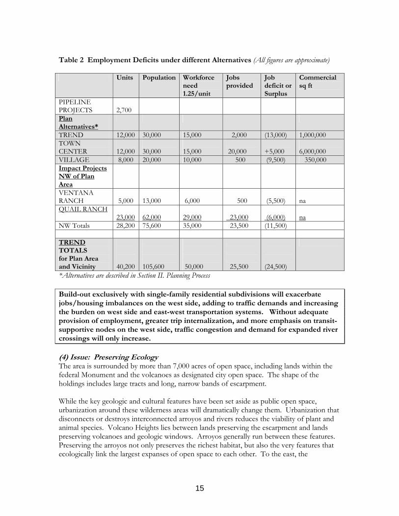
Table 2 Employment Deficits under different Alternatives (All figures are approximate) Units Population Workforce
need 1.25/unit
Jobs provided
Job deficit or Surplus
Commercial sq ft
PIPELINE PROJECTS
2,700
Plan Alternatives*
TREND 12,000 30,000 15,000 2,000 (13,000) 1,000,000 TOWN CENTER
12,000
30,000
15,000
20,000
+5,000
6,000,000
VILLAGE 8,000 20,000 10,000 500 (9,500) 350,000 Impact Projects NW of Plan Area
VENTANA RANCH
5,000
13,000
6,000
500
(5,500)
na
QUAIL RANCH 23,000
62,000
29,000
23,000
(6,000)
na
NW Totals 28,200 75,600 35,000 23,500 (11,500) TREND TOTALS for Plan Area and Vicinity
40,200
105,600
50,000
25,500
(24,500)
*Alternatives are described in Section II. Planning Process Build-out exclusively with single-family residential subdivisions will exacerbate jobs/housing imbalances on the west side, adding to traffic demands and increasing the burden on west side and east-west transportation systems. Without adequate provision of employment, greater trip internalization, and more emphasis on transit-supportive nodes on the west side, traffic congestion and demand for expanded river crossings will only increase. (4) Issue: Preserving Ecology The area is surrounded by more than 7,000 acres of open space, including lands within the federal Monument and the volcanoes as designated city open space. The shape of the holdings includes large tracts and long, narrow bands of escarpment. While the key geologic and cultural features have been set aside as public open space, urbanization around these wilderness areas will dramatically change them. Urbanization that disconnects or destroys interconnected arroyos and rivers reduces the viability of plant and animal species. Volcano Heights lies between lands preserving the escarpment and lands preserving volcanoes and geologic windows. Arroyos generally run between these features. Preserving the arroyos not only preserves the richest habitat, but also the very features that ecologically link the largest expanses of open space to each other. To the east, the
15

ecosystem is largely cut off in Taylor Ranch. However, to the west, the opportunity still remains to link the ecosystem to the Rio Puerco wilderness. The open space that exists within and adjacent to the Plan Area is not consolidated into an overall connected and consolidated network. Drainage channels are not being used to their potential as walking and biking trails that could link the natural open areas. And subdivisions in some cases are not following the City‘s requirement per EC35 for dedicating 30% permanent common open space. (5) Issue: Stormwater Runoff The AMAFCA master plan for stormwater drainage provides for a regional detention basin at Unser and Universe, but does not detail all stormwater facilities. While much of the area's stormwater runoff will need to flow to engineered pipes and channels, the Boca Negra arroyos should continue to act as natural drainage facilities. The arroyos may function as stormwater facilities so long as the preserved swath is wide enough to carry 100-year flows. In addition, AMAFCA requires management and maintenance of the arroyos so that no alterations reduce the flow capacity the arroyos have been planned to carry. (6) Issue: Open Space Edge Treatment The Monument has miles of edge and adjacent private lands are in a natural state. Currently, people access the open space anywhere along the edge and can take in exceptional views of the volcanoes, the Rio Grande valley, and the Sandia mountains. New development could block this physical access and the views, greatly reducing the value of the open space amenity to the public at-large. The open space could best be preserved as a public amenity by designing scenic trails and roads along open space edges. Design standards for developments built adjacent to the open space edge should achieve visual harmony with the high desert landscape.
16

II. PLANNING PROCESS A. Gathering Information Private Development Plans In September and October, the Planning Team assembled information on the current status of development plans through meetings and interviews with City and County planning staff, developers, and property owners. Discussions with the developers of Vista Vieja subdivision occurred throughout the planning process, resulting in adjustments to their master plan that added a hiking and bicycle trail, a central plaza and other “walk-to” amenities, and greater variety of housing types. Similarly the team met with representatives of the Longford Homes and La Cuentista subdivisions and held interviews with representatives of SAD 227 and the Volcano Cliffs Property Owners Association. Public Sector Plans and Policies The Planning Team gathered extensive information on plans for public infrastructure, including drainage, water and transportation systems, and on land use plans and policies. The team met with AMAFCA, the City-County Water Authority, the Mid Region Council of Governments, economic development agencies, and City transportation, and planning departments. In addition, an interview was held with Rio Rancho officials regarding the redevelopment and land assembly process that Rio Rancho is using to facilitate contemporary development standards in areas of obsolete plats. (See Appendix 2) Open Space Archeology, Anthropology ,Interviews with the National Park Service, city open space staff, and state officials provided information on the Petroglyph National Monument and other open space needs. The team interviewed experts knowledgeable regarding the area’s archeology, anthropology and Hispanic and Native American history to understand the cultural background of the area. B. Three Land Use Plan Scenarios Based on analysis of information gained through interviews, agency meetings, and collection of materials, in December of 2004 the team prepared three scenarios that explored different ways to develop. (See Exhibit 8 Comparisons of Trend, Village and Town Center Scenarios) (1) Trend. This scenario assumes extension of current development patterns under present zoning to the undeveloped portions. It illustrates projects that are in advanced and initial phases of development, along with application of similar suburban densities elsewhere in the study area. Lots under 1 acre in the Volcano Cliffs area would remain as platted. Roughly 12,000 dwelling units and few jobs would result under this scenario. (2) Village. This scenario emphasizes protection of open space and cultural resources. Residential areas are organized around walkable villages with modest retail services. Substantial areas would remain rural in character. Roughly 8,000 dwelling units and few jobs would result under this scenario.
17

18 18
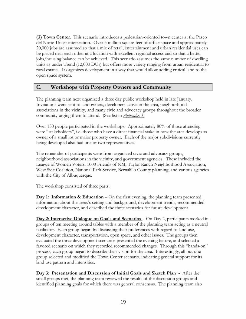
(3) Town Center. This scenario introduces a pedestrian-oriented town center at the Paseo del Norte-Unser intersection. Over 5 million square feet of office space and approximately 20,000 jobs are assumed so that a mix of retail, entertainment and urban residential uses can be placed near each other at a location with excellent regional access and so that a better jobs/housing balance can be achieved. This scenario assumes the same number of dwelling units as under Trend (12,000 DUs) but offers more variety ranging from urban residential to rural estates. It organizes development in a way that would allow adding critical land to the open space system. C. Workshops with Property Owners and Community The planning team next organized a three day public workshop held in late January. Invitations were sent to landowners, developers active in the area, neighborhood associations in the vicinity, and many civic and advocacy groups throughout the broader community urging them to attend. (See list in Appendix 3). Over 150 people participated in the workshops. Approximately 80% of those attending were “stakeholders”, i.e. those who have a direct financial stake in how the area develops as owner of a small lot or major property owner. Each of the major subdivisions currently being developed also had one or two representatives. The remainder of participants were from organized civic and advocacy groups, neighborhood associations in the vicinity, and government agencies. These included the League of Women Voters, 1000 Friends of NM, Taylor Ranch Neighborhood Association, West Side Coalition, National Park Service, Bernalillo County planning, and various agencies with the City of Albuquerque. The workshop consisted of three parts: Day 1: Information & Education – On the first evening, the planning team presented information about the areas’s setting and background, development trends, recommended development character, and described the three scenarios for future development.
Day 2: Interactive Dialogue on Goals and Scenarios – On Day 2, participants worked in groups of ten meeting around tables with a member of the planning team acting as a neutral facilitator. Each group began by discussing their preferences with regard to land use, development character, transportation, open space, and other issues. The groups then evaluated the three development scenarios presented the evening before, and selected a favored scenario on which they recorded recommended changes. Through this “hands-on” process, each group began to describe their vision for the area. Interestingly, all but one group selected and modified the Town Center scenario, indicating general support for its land use pattern and intensities. Day 3: Presentation and Discussion of Initial Goals and Sketch Plan - After the small groups met, the planning team reviewed the results of the discussion groups and identified planning goals for which there was general consensus. The planning team also
19

generated a preliminary “sketch plan” with features common to the plans generated by participants on Day 2. The initial sketch plan and goals were presented to members of the community during a final workshop on Day 3. Comments were solicited as a way of further clarifying issues and preferences to be addressed in subsequent work.
*** The general tone of the workshops moved from frustration at the beginning to one of constructive involvement and creative thinking. On the third day, many participants expressed a desire to continue moving the process along in a cooperative and timely manner.
20

III. WORKSHOP RESULTS and VISION Public Input January 27-29, 2005 Participants supported creating a development character that is different than the rest of Albuquerque, that provides more choice in housing types, creates walkable communities, and offers a connected network of open space and trails. By focusing on comprehensive planning and quality design, participants saw that economic value, resource conservation, and broad city-wide benefits can be realized simultaneously.
General Approach to Development:
• Work within existing platting where possible • In areas where needed, conduct voluntary assemblage / split lots • Use Special Assessment Districts (SADs) and Public Improvement Districts (PIDs)
to enable development; foster cooperative relationship between City and Volcano Cliffs property owners
• Explore role of transferable development rights (TDRs) in land acquisition for open space
• Begin to re-zone for a greater mix of uses, housing types and densities; “zoning for mostly residential is a mistake”
• Develop design standards addressing scale, color, heights, massing, especially for town and village centers
• Pursue inter-agency agreements for joint use and co-location of community centers, schools, parks, recreation, libraries, etc.
Issues: Private sector owners and developers:
• Urge quick action and City facilitation of rapid implementation. Their support is contingent on things moving quickly.
• Stress voluntary assembly process and generally oppose government acquisition of more open space or public uses within the Plan Area unless funding is quickly identified and there is fair and equitable compensation.
• Want to be sure of market feasibility for the types of development proposed. Will people walk to the town and village centers? If not, businesses may not survive. Is there enough market for different residential types?
• Want to avoid slowing down the development approval process in order to implement new types of development.
• Find that standards applied in the current City approval process discourage creative solutions.
Community and neighborhood representatives:
• Desire additional open space to preserve citywide views and respect the land
21

• Consider innovative tools for implementation such as Transferable Development Rights (TDR) for acquisition of open space or reconfiguring densities
• Are concerned about east-west traffic impacts from additional development • Are concerned that the capacity of road network and environmental issues may
constrain amounts of development; concern over impact of development on infrastructure deficiencies on the West Side.
*****
VISION from the WORKSHOPS A CONSOLIDATED, CONNECTED OPEN SPACE NETWORK
• Combine open space and parks into a network with connecting trails • Create walking and biking trails along drainageways and away from major arterial
roads to encourage active use • Clarify stormwater retention policies to allow natural drainageway treatment • Consider adding some additional open space:
Well thought-out widening of the northern narrow strip Adding to the monument buffer where there is an ecological or trail purpose Rural Estates platted areas that are difficult to service Northern portion of the northern geologic window.
• No removal of view lots along the northern “gooseneck” part of the Monument Benefits
• Health benefits to residents derived from recreational trails and walkable destinations built into the community
• Design for the long-term, for future generations, and for the community as a whole; preservation of vistas on western horizon
• Trail system can be a substitute for golf course amenities and set development in this area apart from others
GRADUAL TRANSITIONS BETWEEN OPEN SPACE AND DEVELOPMENT
• Use low walls for privacy yet maintain an open feeling • Maintain security for homeowners through controlled access to and from properties
A TRANSIT NETWORK LINKED TO TOWN AND VILLAGE CENTERS, EMPLOYMENT DESTINATIONS AND THE REST OF THE TRANSIT SYSTEM
• Consider future light rail or bus rapid transit along limited access corridors; Paseo and Unser alignments should include adequate right-of-way for transit
• Offer urban residential choices within walking distance of transit • Relieve traffic congestion, especially across river
22

A TRANSPORTATION NETWORK THAT INTEGRATES LIMITED ACCESS ARTERIALS WITH DESIRED PEDESTRIAN-ORIENTED LAND USES
• Coordinate design of road system with plans for town and village centers to create pedestrian-oriented character; reduce minimum intersection spacing in the town / village centers to 1/4 mile
• Explore alternative intersection design techniques (e.g. circles, roundabouts) A TOWN CENTER AT THE INTERSECTION OF PASEO DEL NORTE AND UNSER THAT DEVELOPS IN A NEW URBAN WAY WITH MIXED-USES, PEDESTRIAN-ORIENTATION SCALE AND ACTIVE STREET FRONTAGES
• Employment / retail accessible and within walking distance of housing • Minimize impact of parking; no big box retail • 3-4 stories heights • Consider realignment of Paseo and Unser intersection to create a large contiguous
Town Center • Slow traffic through Town Center; explore feasibility of 1/4 mile intersections with
pedestrian crossings • Consider loop around Town Center to distribute traffic; provide regional access
Benefits: • Greater clustering / density in centers leaves more open space elsewhere • Improve jobs / housing balance and services for the large northwest population • Provide sufficient employment to capture employment trips and help reduce east-
west traffic especially across river VILLAGE CENTERS FOR RESIDENTS TO WALK TO THAT COMBINE DAILY SHOPPING, NEIGHBORHOOD SERVICES, SCHOOLS, COMMUNITY CENTERS, AND OTHER CIVIC USES
• Co-locate schools, parks, recreation, libraries, community centers, police / fire substations
• Emphasize mix of uses, to include retail and residential along with civic • Heights 2-3 stories • Join civic uses with open space network • Placing new high school next to the Village Center creates an opportunity to “jump-
start” a sense of place • Co-locate schools (e.g. high school and middle school) separated by playing fields or
street (some want high school and middle school separated); suggest placing high school auditorium on the corner near the Village Center
23

A GREATER VARIETY OF HOUSING THAT INCLUDES TOWNHOMES, CONDOS, LIVE/WORK UNITS AS WELL AS SUBURBAN SUBDIVISIONS
• Encourage blending into landscape - southwest style, earth colors; adobe or stucco materials
• Support pedestrian-oriented character • Retain light, space, views • Minimize visual impact of parking • Avoid large concentrations of renters
EXECUTIVE QUALITY RURAL ESTATES LOCATED ON THE WESTERN PORTION
• Consider clustering of homes • Maintain housing quality on large lots • Determine how best to serve with utilities; consider joint wells, cooperation with
NM Utilities, or City service extensions • Determine how large an area can be served by utilities; consider unserved portion for
open space • Septic issue – emphasize safety and consider innovative and green technologies
ELEMENTARY SCHOOLS THAT STUDENTS CAN SAFELY WALK TO WITHOUT CROSSING BUSY STREETS
• Evaluate the need for schools considering demographics of area; evaluate need for elementary school near La Cuentista
• Location of schools – safe walkable routes from residential areas, no schools that would block views
• Consider designing school sites to be smaller, more pedestrian-oriented, less car-dependent, and more connected to the community
**** The participants in the workshop identified key NEXT STEPS to realize the desired goals. 1. Define subareas for sector plans and infrastructure. Tie SADs and PIDs to sector plans. 2. Refine appropriate building scale, heights and color for the different subareas.
• New street and infrastructure standards; new form-based zoning categories and design standards for town and village centers
3. Create and circulate timeline for completion of planning and regulatory change 4. Agreement on phasing and sequencing, schedule for development
24

5. Conduct further studies:
• Market Studies and Market Acceptance Strategy – commercial / office demand, employment, urban residential types
• For Town Center, determine absorption and sequencing of employment over time; investigate types of employment that would be complementary to Double Eagle and Quail Ranch
• Regional Transportation and Transit Study and assessment regarding impact of the plan on regional system and land use relationships
IMMEDIATE ISSUE TO RESOLVE Be proactive to resolve Unser / Paseo alignments and intersections treatment. Consider impact of realigning Unser with respect to timeline and existing environmental clearance.
25

IV. CONCEPT PLAN (See Exhibit 9 Concept Plan)
A. Land Use After the January workshops, the Planning Team worked to draft a Concept Plan consistent with professional norms and based on property owner and community preferences. The Volcano Heights Concept Plan represents a comprehensive strategy for development, which:
• clusters complementary land uses within walkable centers and neighborhoods, • supports walking and transit for many trips (and reduces reliance on the car), • offers a range of housing opportunities, • begins to balance jobs and housing on the west side, • protects significant ecological and cultural features, • provides a continuous open space and trail network, • anticipates future demands for schools and parks, • encourages an interconnected roadway network to maintain pedestrian-friendly
volumes, and • considers the realignment of major arterial roads to establish a larger, contiguous
“Town Center.” The study area has the rich natural features—volcanoes, views, and large tracts of open space—that attract quality employers and quality homebuilders. Most development in the Volcano Heights Concept Plan is organized within “Villages” and a “Town Center.” Villages and the Town Center concentrate housing within walking distance of retail conveniences, restaurants, schools, parks, community facilities, and regional transit. Tree-lined streets and attractive street-facing architecture will encourage walking, and help reduce reliance on the car. Development will incorporate many features and the scale of traditional towns and neighborhoods in New Mexico, such as porches, verandas, and storefronts along streets. Three Villages are shown in the Concept Plan. Two Villages are along Paseo del Norte at Universe and farther west. Each Village has a small mixed-use center, where neighborhood retail conveniences and community amenities are provided near the transit stop. Some multi-family housing might also occur next to or above retail uses, but buildings would not exceed 3 stories. Urban Residential areas are within a short walk of the Village Centers. Urban Residential areas contain a variety of housing types including courtyard housing, loft apartments, townhouses. duplexes, small cottages and single-family homes on smaller lots. An average density of 12 dwellings per gross acre has been assumed for Urban Residential areas.
26

27

A third Village brings amenities and services to the center of the Plan Area. Known as “Volcano Cliffs,” this area has many smaller lots. A mixed-use Center occupies the only parcel large enough to accommodate neighborhood retail -- without lot assemblage. High school facilities that serve the community, such as the auditorium and recreation, are depicted in a building immediately adjacent to the Village Center to help concentrate activities. Within a short walk of Village Center activities, the Urban Residential designation indicates where smaller lots could be split, or have duplexes or small apartments. On both sides of Rainbow Avenue, State lands have already been acquired for a new high school and a potential middle school. The program and acreage for these facilities is still to be determined. Where possible, school facilities that benefit the larger community occur next to Village Centers. The Town Center contains a greater range of destinations than Villages – some of which may have a regional patron base. Besides neighborhood conveniences, the Town Center may contain theatres, department stores, or a library. Courtyard housing, condominiums, and loft apartments are anticipated next to and above retail uses. While 1-3 story buildings are likely to predominate, some 4-5 story buildings are anticipated. At the center of the Town Center, urban uses frame a “town square” for passive recreation, events, and an identifiable and marketable sense of place. Residents in nearby Urban Residential areas can take advantage of these exceptional features on foot. The Town Center concept is made pending court approval and the construction of Paseo del Norte. If this does not occur, the Town Center could be relocated within the Plan Area. Office campuses are also within walking distance of Town Center destinations and regional transit. At urban intensities (3-stories with 2-level parking), office uses in this location can help correct the imbalance between housing and jobs on the west side. A better jobs-housing balance will help reduce commute distances and help reduce congestion on regional roads – especially if attractive transit options are also in place. While the west side has seen few office campuses to date, high-quality housing, transportation, and conveniences often play an important role in attracting major businesses. A large contiguous area will make a more viable Town Center -- robust enough to attract businesses and finance public improvements. Major arterial roadways present severe obstacles to pedestrian movement and comfort. The planned alignment for Unser has adjusted, therefore, so that the mixed-use synergies of the Town Center can be realized. More frequent intersection spacings (from ½ mile to ¼ mile) are also proposed along PdN and Unser in the vicinity of the Town Center, so that office workers and residents can reach the Town Center more directly -- and to make the Town Center more viable economically. Given two additional intersections, potential increases to through-traffic travel times should be studied, but are expected to be modest. Outside the Villages and Town Center, Suburban Residential uses will predominate, the average density for which is slightly higher than recent single-family development in the area. In the southwest portion of the Plan Area, Suburban Residential is far from Village Center conveniences, so two mixed-use areas have been shown. These areas may include convenience retail, at-home businesses, and/or community facilities. In the southwest
28

subarea, Executive Residential helps further diversify housing in the Plan Area, and will help attract new employers to the area. Farther west, Rural Estates maintain the existing parcel pattern with lots generally exceeding 10 acres. The Rural Estate area lies in a water district zone where service is not presently planned. Building sites may be brought closer together in low-density areas to leave more area undisturbed and to provide long, uninterrupted views. Lower-densities and open space along the western portion of the Plan Area help maintain a more scenic foreground to Albuquerque’s dormant volcanoes. Table 3 Concept Plan Assumptions *(All figures are approximate) Use Average
Gross Density Dwelling Units
Commercial Floor Area (SF)
Pipeline Projects (1) 4.5 du/ac 3,800 Volcano Cliffs Lots (2)
400
Town Center 12 du/ac 1,000 1,100,000 Village Center 10 du/ac 500 1,000 Urban Residential 12 du/ac 3,500 Suburban Residential 4.5 du/ac 2,600 Executive Residential 0.5 du/ac 100 Rural Estates na 100 Office Campus 3,900,000 TOTAL 12,000 5,001,000 *Source: Catalyst 30,000 16,000 Population Jobs (1) Pipeline Projects are described on page 3 (2) Volcano Cliffs Lots include those under 1 acre, minus lots that can be subdivided or intensified (and are included within Village Center or Urban Residential designations) B. Open Space Network A connected open space network (See Exhibit 10 Open Space Network) features prominently in the Concept Plan. The network conserves sensitive arroyo habitats, rock outcroppings, and some archaeological sites within the Plan Area. The network connects Volcano Heights developments to the more than 7000 acres of open space already set aside as federal/city open space. Key east-west ecological linkages are made between the volcano area and the escarpment. A buffer is also added along the narrowest strip of the escarpment. Trails follow the open space network, producing exceptional recreational opportunities for hiking, bicycling, and education. Parks, schools, and civic uses are placed along the open space network, making them accessible via the trail system. Besides providing protected routes for children, this arrangement also makes more efficient use of open space. School sites are distributed throughout the Plan Area, in a way that minimizes walking distances and
29

30 30

the need to cross busy streets. Joint use of parks and schools is assumed. School sites that are not needed may be used for parks or other civic uses. The open space network also functions as a stormwater facility, reducing needs to 'engineer' the drainage where arroyos exist. A key facility is a detention basin at Unser and Universe, which will double as a regional park. The Upper and Middle Forks of the Boca Negra arroyo are shown as 200-foot wide corridors. More study is needed to determine if this width is correct to accommodate a 100-year flood event. Acquis tions: i (See Table 4) The methods of acquiring the new open space lands will vary. Some public funds will be necessary. Other strategies involve developer dedications, small area replatting, and transfers of development rights across the Plan Area (see Section IV. Implementation ). Rock outcroppings and other smaller features worthy of preservation should be identified in future planning efforts and by means of surveys required at the time of zoning or site planning. Site designs should incorporate these features into the layout of the site. For additional detail on acquisitions, please see Appendix 4. Scenic Roadways and Trails The Concept Plan emphasizes local streets lining much of the open space edge, in contrast to private backyards. The roads allow many people with varying physical abilities to experience the open space and see the views, without producing foot traffic across sensitive lands. The local road design is narrow or discontinuous to discourage high-speed, through travel. An exceptional scenic experience is a road and trail paralleling the escarpment edge from Boca Negra Canyon to the Piedras Marcadas Canyon. A trail lies between the road and the escarpment and continues the length of the escarpment, even where the road is discontinuous. The road near the trail provides additional “eyes on the trail” to enhance safety. The other open space edges in the Plan Area have the same edge treatment of road, trail, open space, to the extent feasible.
31

The following Table 4 outlines future acquisitions for consideration: TABLE 4
Map Refer-ence
Location Acreage
Benefit of Acquisition Current Owner-ship
1 North Geologic Window
120 Complete Acquisition: Land is already designated part of Petroglyph National Monument (PNM), but land has not yet been acquired.
Three parcels
2 Piedras Marcadas Parcel
8 Complete Acquisition: Land is already designated part of PNM, but parcel has not yet been acquired.
One parcel
3 Western half of State Land Parcel
50 - 135
Archaeology: Ice age man sites dating back 12,000 years. (Small site west of Atrisco may be incorporated into high school site.) Arroyo: Preserves a key section of the Upper Fork of Boca Negra Arroyo. Ecology: Birds in numerous juniper stands
State Land Trust
4 Boca Negra Unit to La Cuentista
50 Ecology: Buffer the narrowest segment of PNM to Preserve the ecosystem. Currently receives the majority of PNM visitors.
Numerous small lots
5 Piedras Marcadas Unit
35 Ecology: Buffer the Piedras Marcadas Unit and future Paseo del Norte Road. Increase preservation of the ecosystem.
A few large parcels
6 Middle Geologic Window landlocked parcels
65 Inaccessible Area: Parcels are landlocked on west by PNM and on the east by the Middle Geologic Window (future public park). Difficult to build a road and bring utilities to parcels.
Ten large parcels
7 Boca Negra Arroyos (Upper and Middle Forks)
30 Arroyo: Upper and Middle Forks of the Boca Negra. Public fund may be needed to leverage property owner dedication of wide enough swaths to preserve ecology. Coordinate with AMAFCA.
Portions of several 5-15 acre tracts.
8 La Cuentista 15 Ecology: Another narrow portion of PNM. Private developer is planning to set aside areas, but as private open space. May be beneficial to have public acquisition to set some land aside as public.
Legacy Develop- ment
In some loca-tions
Scattered Rock Outcrops with Petroglyphs
N/A Archaeology: A few scattered sites have been identified. Require archaeological survey as part of site plan submittal.
N/A
Through-out Area
Volcanic knolls, ridges, push-ups, or significant stands of junipers
N/A Ecology: Features that hold water and have higher biodiversity. Add interest to area; reminders of native habitat. Archaeology: Viewpoints and resting areas. Require natural feature/archaeological survey as part of site plan submittal.
N/A
32

C. Transit and Transportation Regional transit serves the Villages and Town Center, with station locations within walking distance of major destinations and higher density housing and employment. Transit-oriented development has been shown to greatly reduce car use in studies nationally. Transit routes are recommended along Paseo del Norte and along Unser. Planned high capacity service along Paseo del Norte might be extended farther west and help connect west side housing to jobs near the I-25 corridor and commuter rail service. Planned high capacity service along Coors Boulevard might be extended through the Plan Area and to other points to the north via Unser Boulevard. Unser is the main north-south transit route, as it is planned to serve as a regional connector all the way from Rio Bravo on the south and north to Rio Rancho. On the Albuquerque / Bernalillo County Centers and Corridors Plan it is designated as an Express Corridor, providing express bus service. Light rail or bus rapid transit are examples of high capacity premium transit service that move riders quickly and reliably along dedicated routes, thereby avoiding the lengthy travel times and delays that occur when bus service is mixed with other traffic. Bus rapid transit (BRT) is suggested in the near term. Alternative fuel buses and bus-only travel lanes make BRT fast, reliable, and attractive – for a fraction of the cost of light rail systems. Right-of-way set aside for Paseo del Norte and Unser should be examined with regard to their ability to dedicate sufficient dimensions for light rail or bus rapid transit, although planned medians appear to provide sufficient opportunity where left-turn pockets are not needed.
33

D. Development Character Illustrations 1-5 depict the character envisioned for the various land use categories on the Concept Plan.
Mixed-use Town Center The Town Center occupies the large contiguous development area just east of the Unser – Paseo del Norte intersection. The Town Center will include a mix of retail, entertainment, housing, office, and community uses. Buildings and building entries will be brought close to streets to create a walkable urban environment. Walking will be further encouraged with attractive tree-lined streets. Besides on-street parking, parking will be placed behind or, where cost-effective, below buildings. A “town square” will bring passive recreation, a place for events, and a sense of identity to the center of the Town Center. Taller buildings, up to 5 stories in height, are anticipated around the town square, and close to regional transit at the Unser – Paseo del Norte intersection. The illustration shown depicts the town square surrounded by mixed-use buildings with retail on the ground floor and residential or office uses above. The height of buildings will transition to 3-stories where the Town Center abuts residential areas.
Illustration 1
34

Mixed-use Village Centers Three Villages are depicted within the Plan Area. In these Villages, Urban Residential lies within a short walk of a mixed-use Village Center. The mixed-use Village Center contains neighborhood retail and services, community uses, professional offices, and housing. Building heights will be generally two to three stories, with housing above retail surrounding a “village green” or traditional “main street.” Generous sidewalks, street trees, canopied storefronts, and “portales” will create an inviting retail environment that can be approached comfortably on foot. On-street parking (diagonal or parallel) supports street-facing retail and other uses. Streets should be aligned to take advantage of views to the volcanoes and Sandia Mountains.
Illustration 2
35

Urban Residential Neighborhoods Urban Residential neighborhoods will concentrate homes within a short walk of the Town Center, the Village Centers, and transit, while also maintaining a highly livable and attractive environment – similar to what is often seen in New Mexico’s traditional neighborhoods. A variety of housing types will be encouraged within these neighborhoods, including courtyard housing, loft apartments, townhouses, duplexes, small cottages, and single-family homes that share a lot with an ancillary apartment (sometimes known as a “granny flat). Small offices, corner stores, artists studios may also be accommodated. Building heights will range from one to three stories. Parking may be in protected mid-block “courtyards” for higher densities and within garages off rear lanes for lower densities. Trees can be planted along the street in rows or in groups, to open important views. Rock outcropping can be incorporated in yards or shared open space. Native vegetation is encouraged.
Illustration 3
36

Suburban Residential Neighborhoods The illustration depicts the character of a neighborhood in Suburban Residential areas. A mix of single-family housing types will be encouraged, including townhouses, duplexes, detached units on small lots, and detached units on large lots. The housing addresses streets with building entries and windows, as well as courtyards and gates. To maintain a more active, pedestrian-friendly street frontage, garages are recessed behind the front of buildings or are served by a rear alley. Build-to lines near the street will bring buildings forward and allow for bigger side and rear yards -- a traditional New Mexico pattern. Streets will be designed to slow traffic. Trees would be concentrated in small parks, along with maintained turf for play. Naturalized swales receive stormwater run-off to support vegetation and wildlife, and improve water quality.
Illustration 4
37

Neighborhood Edge / Transitions Landscaping and buildings, in addition to roads, are transitions from the natural desert to the built environment. Generally, low density, one-story residential development abuts the open space. Design guidelines emphasize fencing that retains an “open” feel. Building colors and landscaping materials are in harmony with the desert palette. Environmental and aesthetic benefits accompany a clear demarcation between the built environment and nature, as is illustrated. Doing so helps to conserve natural features and opens dramatic views of the area’s scenic features. Native vegetation should be used. Inhabited uses should activate the edge, whenever possible. Where larger lots are anticipated, small outbuildings or building wings can create an “inhabited wall” that avoids the monotony of an uninterrupted wall of uniform character. Preferred treatments include stucco walls, split rail, or “coyote fencing,” as is seen in many small rural communities.
Illustration 5
38

V. IMPLEMENTATION STRATEGY
A. OVERVIEW While planning establishes the City's overall vision for the area, plans are not self-implementing. Appropriate regulatory, financial, and public investment tools must be used to achieve the policies established in the plan. To implement the Concept Plan, the consultant team is recommending a package of implementation strategies that: • help realize Concept Plan and other development features that support goals and
objectives identified through the planning process • implement the City/County Comprehensive Plan, Westside Strategic Plan, Northwest
Escarpment Plan, and the Planned Growth Strategy; • respond to the public comments and agency concerns; • is legally defensible; and • avoids the need to acquire property through eminent domain to the extent possible. There are four basic categories of strategies that have been considered to implement the Volcano Heights Concept Plan. These include: planning and design strategies, growth management controls, financing and platted land or redevelopment strategies,. These are described as follows: • Planning & Design uses existing or new regulatory tools, such as the City's zoning and
subdivision regulations, or new form-based codes and sector plans, to encourage the type of development envisioned in the Concept Plan. Revisions might be needed in the City's subdivision regulations and Development Process Manual to implement street design and urban and rural concepts being considered.
• Growth management controls time and sequence of development in the Concept Plan area in order to prioritize infrastructure improvements, and to provide infrastructure in an orderly and cost effective manner.
• Financing tools discuss ways to finance the provision of infrastructure in the Plan Area. Landowners in SAD 227 have already used special assessment districts to finance infrastructure and open space acquisitions, a device that may also benefit the Volcano Cliffs Subarea. Business Improvement Districts represent another vehicle for financing improvements such as infrastructure, open space, or parking structures.
• Redevelopment strategies use the land acquisition, regulatory and financing powers of the New Mexico Metropolitan Redevelopment Code to reassemble existing development or lots. The Concept Plan eliminates the need for a wholesale condemnation of subdivision plats and re-subdivision similar to that used in Rio Rancho. However, redevelopment powers may be needed in an extremely limited way to realize some features.
The Concept Plan recommends a combination of the residential zoning and special zones or zoning techniques to implement the land use plan. Most of the area will remain residential as
39

it is currently platted. Areas with higher density residential and non-residential uses will be covered by sector plans enabling zoning with SU-2 or SU-3 or by new mixed-use zones as contained in the Planned Growth Strategy to encourage a mix of land uses in accordance with the land use plan. SU zones may contain a mix of uses and specific requirements for site and building design, perimeter walls, pedestrian access, landscaping and common areas. The City's "SU-2" special neighborhood zoning and “SU-3” Urban Center zoning is a flexible tool for permitting mixed use development. The SU zones require approval of a sector development plan by the planning commission and City Council. The sector development plan controls development of an SU zone. An advantage of the SU zone is its flexibility. Development standards can be crafted for the specific types of development and vision for the area. A disadvantage of the SU zoning is that the discretionary review process, delay and expense associated with obtaining approval could discourage the innovative types of development recommended for this area. The Use Patterns concept is a flexible alternative to planned development zoning such as the City's SU process. Specific design standards can be crafted and built into the zoning ordinance for development patterns such as planned villages, transit-oriented development, conservation subdivisions, commercial centers, and office campus developments. The Planned Growth Strategy resolution, Council Bill No.. F/S R-02-111, proposes a number of new zone categories that would be useful in implementing the Concept Plan. The standards are very specific, in order to protect surrounding neighborhoods and to provide predictability in the development approval process. However, developers that comply with the Use Pattern can proceed directly to site plan in building permit approval, without having to undergo a discretionary review process. The intent is to streamline the permitting process, while at the same time protecting surrounding neighborhoods. Form-based zoning replaces the conventional use restrictions and provides a more flexible approach to how uses are permitted. Form-based zoning uses scale and design to resolve compatibility issues. Transitional densities can be required between the heart of residential neighborhoods and the heart of corridors or centers. This may include primary, secondary and tertiary densities or building envelope standards. The form-based zoning can be accomplished in several ways: • Establish variable building envelopes for areas interior to corridors and on the edge
of corridors (exterior). Under this option or under any of the options discussed below, the neighborhoods exterior to the corridors provide the tertiary densities.
• Provide “Neighborhood Edge” and “Corridor Edge” standards for commercial corridors. The Neighborhood Edge criteria would permit garage apartments and smaller-scale retail and service uses along the edge of the corridor abutting residential neighborhoods. The Corridor Edge would permit higher densities along with appropriate architectural restrictions and, in suburban corridors, buffering.
• Establish transitional zoning districts, and identify in purpose statements the districts or areas that a designated district may abut.
• Establish and refine locational standards for parking, landscaping, and detention/retention facilities to buffer commercial uses and neighborhoods. In traditional neighborhoods, midblock locations and other solutions should be permitted in order to retain the walkable scale of the neighborhood. Landscaped
40

buffer requirements should be minimized in traditional neighborhoods. In suburban neighborhoods, landscaped buffers are a viable solution.
Form based zoning is a flexible concept that can be built into a sector development plan or new zoning categories or regulations. The City already imposes design standards on a limited basis for office/institutional, commercial, retail, and service uses on sites that are at least five acres (City Code § 14-16-3-18). These regulations apply to pedestrian facilities, building massing, building design, and public spaces. Recently the City Council adopted the Huning Highland EDo (East Downtown) plan that contains an extensive set of design standards. TDR - Another implementation tool could include transfer development of rights (TDR). The TDR concept would allow the transfer of densities in areas abutting open space or in lower density areas to higher density areas. Areas from which development rights are sent are referred to as "sending areas," while areas that receive development rights are referred to as "receiving areas." Receiving areas could include either the Town Center Subarea, or other areas of the city that are suitable for more intense development. The ratio of development rights transfers from the sending to the receiving areas should be carefully calibrated to ensure that there is sufficient incentive to use the TDR program, while avoiding over- development of the receiving area. In addition, some communities facilitate transfers of development rights through a TDR bank.
Demand for development rights is critical to the success of the TDR system. Before instituting the TDR concept, a market study should be conducted to quantify development land values and construction costs in the sending and receiving areas, to ascertain the viability of transfers, and develop appropriate transfer ratios. Land Assembly Strategies
The City recognizes the need for both public and private strategies to foster assembly and replatting, and development at urban densities in the Plan Area. Development to date has relied on private sector initiatives to assemble, replat and develop property in the area.
Smaller scale land development is less successful than larger scale development in accomplishing the goals of the Comprehensive Plan. It also makes financing of large scale infrastructure improvements more difficult. The purpose of public strategies is to make land assembly and platting for urban development easier to accomplish for larger subareas.
The following implementation techniques are possible ways to encourage land assembly and fund public improvements that are normally provided by the developer.
• Use of “windows” to encourage land assembly – In other areas with multiple owners similar to Volcano Cliffs (e.g. La Cueva), the City has encouraged land assembly by subareas called “windows.” Access to utilities was denied until assembly and replatting occurred. Development on this scale makes it possible to align drainageways and streets consistent with topography and drainage patterns, install public infrastructure and provide for urban residential densities and mixed land uses. If landowners within a window do not agree to participate in overall development, it is more difficult to plan for the window and fund infrastructure.
41

.
• Special Assessment Districts - A special assessment district (SAD) would assess property owners in a window or Subarea for local serving facilities such as the cost of streets, drainage improvements and water and sewer lines. A sector development plan could require dedication of right-of-way, open space, and any needed assembly of parcels. An SAD may be proposed by the City or by owners of 51% of the land area in the window or Subarea. In any case, owners of 51% of the land must agree. Interim solutions may be necessary if utility and drainage linkages are not in place outside the window.
• Special Assessment District for entire Plan Area - A special assessment district for the entire Plan Area could be implemented to fund streets, drainage improvements and public utilities, etc.. This is a major undertaking, and the phasing of improvements under this alternative must be carefully evaluated to meet the needs of individual landowners.
• Rely on private sector to assemble land and install infrastructure - To date, the City has relied on the private sector to assemble land and install public infrastructure. Development is taking place, and the private sector can continue to build without City intervention. The Concept Plan recognizes that current zoning allows urban development without large scale assembly.
• Development fees. As established by City ordinance, a development fee would help pay for off-site master plan infrastructure. The rate at which fees are collected would impact the rate at which improvements would be made. This funding mechanism would not pay for on-site infrastructure improvements. If this is the selected strategy, less assembly will take place and infrastructure improvements may be piecemeal.
B. IMPLEMENTATION STRATEGIES BY SUBAREAS The following Exhibit 11 Subareas Concept provides a schematic of each implementation Subarea, along with a brief description of the implementation tools associated with the Subarea. These should be implemented through a unified plan for the entire area and City-initiated sector development plans for each Subarea. The Longford Subarea could be carved out and developed under a privately initiated sector development plan in cooperation with the City and consistent with the master planning that is already occurring in that area. These strategies are described in further detail below.
42

43 43

Town Center Subarea The Town Center is characterized by multiple land ownership. Voluntary lot assembly has occurred and is continuing.. There is a high public benefit associated with development of this area. Accordingly, a high level of public participation is recommended in order to encourage the development of this area as a relatively intense, mixed use center. It is designated for a variety of land use categories including a mixed use town center, office campus development, urban residential, and suburban residential on the fringes of the Subarea. The Town Center would be implemented pending court approval and the construction of Paseo del Norte and realignment of Unser. If this does not occur, an alternate location within the Plan Area would be considered.
The town center and village center portions of this Subarea require significantly greater flexibility and design control than is provided by the existing R-D zoning. Alternatives to achieve the mixed use design concept envisioned in this area include: • using the City's existing "SU" zoning along with a sector development plan; • using "form-based" zoning as part of a sector development plan or new zoning
classification, or • streamlined "Use Pattern" regulations that couple design standards with this streamlined
permitting. It is recommended that the Town Center include Use Patterns for the following, building on the guidelines established in the Planned Growth Strategy resolution: • Commercial Center designation for the Mixed Use land use category. Commercial
Center standards would include pedestrian scale design, restricted frontage of building facades, rear parking, buildings oriented to the public realm, an interconnected street system, public spaces, landscaping and xeriscaping, transit, pedestrian and biking compatibility, higher density residential development, design standards, integration of historic/cultural features, and other elements as needed.
• Campus or Employment designations for the Office Campus land use categories. Campus is used for the unified development of office, industrial, institutional and residential uses and includes the following elements: a minimum open space
44

requirement, landscaping and xeriscaping, pedestrian and bicycling linkages, retail and restaurants, transit orientation, possible higher density residential, public spaces, design standards, integration of historic/cultural features of the built and natural environments, and other elements as needed. This zone should be located near major transit and vehicle movement corridors and provide easy access to other zones within the community.
• Urban Residential. This would include design standards for higher density residential or mixed use building types, such as live-work units. Standards would include buildings oriented toward the public realm (e.g., streets and parks), interconnected pedestrian and traffic routes, narrow traffic lanes, short blocks, landscaping and xeriscaping, open space, integration of historic/cultural features of the built and natural environments, design standards, and other elements as needed.
• Suburban Residential. This is an area with single-family detached buildings, townhouses, and duplexes. It includes design standards to orient buildings to streets and the public realm, fencing, and other standards as appropriate. The lot pattern for suburban residential in this area could be more urban than in other parts of the planning area.
• Rural Residential
Volcano Cliffs Subarea Volcano Cliffs is an area characterized by multiple parcels, along with an area to the west that is appropriate for limited mixed use development. The concept plan builds on the existing lot pattern in the area. Rapid implementation of the plan is desired by landowners in the Subarea.
The following zoning standards would be developed: • Planned Vil age Development for the Mixed Use Area. This would include a
central plaza, central commercial and public facility area, central park/plaza, mixed-density residential with higher densities closer to the central plaza, buildings oriented toward the public realm (e.g., streets and parks), interconnected pedestrian and traffic routes, narrow traffic lanes, short blocks, landscaping and xeriscaping, open space,
l
45

integration of historic/cultural features of the built and natural environments, design standards, and other elements as needed.
• Urban Residential standards for the areas surrounding the Mixed Use land use category. This would be similar to the standards that apply to the Town Center Subarea, but with more restricted height and massing.
• Suburban Residential for the existing residential lots. A setback would be established for the escarpment area in order to prevent the intrusion of buildings, fences, and other elements.
Scenic Subarea The Scenic Subarea is characterized by multiple lots under the original Volcano Cliffs Master Plan. Lots are larger than the balance of the Plan Area, ranging from ten to twenty acres. Voluntary lot assembly is already occurring in that area on a limited basis.
Lots in this area are primarily Suburban Residential, with limited potential for a Commercial Center in the northern part of the Subarea. A new zoning classification is recommended for the Rural Estates and Executive Residential land use categories. This zoning classification would require minimum lot sizes equal to the existing subdivision plat or the average lot size in the area (10-20 acres), with new subdivisions prohibited or restricted. Uses would be restricted to single-family detached dwellings or agricultural support uses.
Longford The Longford Subarea is controlled by a single developer. The land use categories are predominantly Suburban Residential and Urban Residential, with a small mixed use area to the north. The land use categories are largely as described above. Development might be controlled through the existing development review process, with consideration of alternative zoning provisions to realize Plan Area goals. Because there are currently no formal approvals for the project, a Sector Development Plan could be initiated by the developers in partnership with the City.
46

C. TIMING AND PHASING The timing and sequencing of development in the Plan Area will provide for orderly development and expansion of public facilities. This will provide assurance to landowners that the development process will be supported, while ensuring that facilities are expanded in a cost effective and efficient manner. Timing and sequencing tools include the following: • An adequate public facilities ordinance that ties new subdivision plats and building
permit approvals to level of service (LOS) standards for roads and other infrastructure. Higher (less congested) standards would apply in the Scenic and Longford Subareas, with more intensity permitted as development proceeds closer to the Town Center Subarea. The standards would be coupled with urban and rural street design in order to support the type of growth envisioned for the area.
• A capital improvements program that stages and sequences major improvements in the area, with priority assigned to the Town Center and Volcano Cliffs Subareas.
• Special assessment or public improvement districts designated for the Town Center and Volcano Cliffs Subareas. Special assessment or other improvement districts would not be permitted in the Scenic Subarea until the Volcano Cliffs area is built out.
47