virginia’s natural area preserve system · virginia’s natural area preserve system 1...
TRANSCRIPT
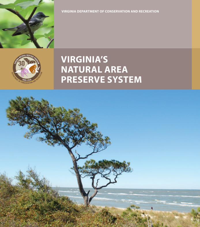
VIRGINIA DEPARTMENT OF CONSERVATION AND RECREATION
VIRGINIA’S NATURAL AREA PRESERVE SYSTEM
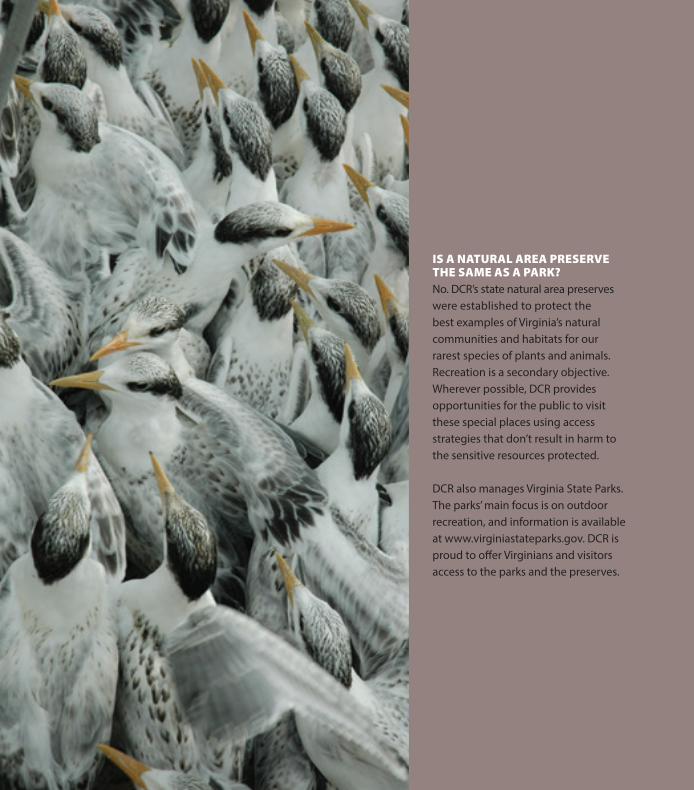
IS A NATURAL AREA PRESERVE THE SAME AS A PARK?No. DCR’s state natural area preserves were established to protect the best examples of Virginia’s natural communities and habitats for our rarest species of plants and animals. Recreation is a secondary objective. Wherever possible, DCR provides opportunities for the public to visit these special places using access strategies that don’t result in harm to the sensitive resources protected.
DCR also manages Virginia State Parks. The parks’ main focus is on outdoor recreation, and information is available at www.virginiastateparks.gov. DCR is proud to offer Virginians and visitors access to the parks and the preserves.
Virginia’s Natural Area Preserve System 1
Virginia’s Natural Area Preserve System includes some of the most beautiful, interesting and unusual natural features in the state. Natural area preserves harbor many of Virginia’s exemplary natural communities and rare species habitats and provide visitors unique outdoor experiences. We invite you to discover the 20 preserves listed here — some of Virginia’s greatest treasures.
The preserves include examples of natural communities from nearly all areas of the state, a strategy that helps protect both common and rare plants and animals. From karst (limestone) landscapes of sinkholes and underground streams in Lee County to giant bayside sand dunes on the Eastern Shore, the preserve system protects outstanding examples of natural communities and the habitats of rare, threatened and endangered species.
PUBLIC ACCESSPublic access on natural area preserves is available for those who are looking for quiet and relaxing time away from crowds. Visitors commune with the natural world while hiking, canoeing, taking photos and observing wildlife. You will notice that parking areas are small — usually from four to 20 spaces. This is intentional. A full parking lot indicates that the preserve has reached capacity, so please return another time when it’s less crowded.
Many preserves not listed here have no access facilities but may be visited by contacting DCR Natural Heritage Program staff. Some preserves may also be closed at times for management activities, such as prescribed burning and invasive species control, or to protect sensitive species.
Welcome
2 Virginia’s Natural Area Preserve System
PLAN AHEAD• Research your route before your trip. For driving directions to any of the preserves,
visit www.dcr.virginia.gov/natural-heritage. • Carry maps, a compass or GPS unit and plenty of drinking water. • Research and keep an eye on weather conditions. Know your limitations and skills,
as well as those of your group.
BEFORE YOU VISIT• Some preserves are open year-round, from sunrise to sunset. However, others
have limited hours and may be closed for management purposes. Before you visit, check the preserve’s web page at www.dcr.virginia.gov/natural-heritage/natural-area-preserves.
• Poor, or lack of, cell phone coverage is common. Always tell someone where you are going before you visit a preserve. Trails may be steep, narrow and remote. Most are inaccessible to emergency vehicles. There is unlikely to be DCR staff on site when you visit a preserve, so be prepared and have an emergency action plan.
RESPECT THE RULES• Park only in designated spaces.• If the parking area is full, the preserve is at maximum capacity. Please come back
another time. • Read and obey posted signs. • Keep pets leashed. • Horses, bicycles, ATVs and off-road vehicles are not allowed. • Preserve the past; examine but do not remove cultural or historic artifacts. Leave
rocks, plants, animals and other natural objects as you find them. • Camping and fires are not allowed.
WILDLIFE• Respect wildlife and observe wild animals from a distance. Use binoculars and cameras. • Never feed wild animals. Feeding wild animals damages their health and exposes
them to predators and other dangers. • Avoid wildlife during sensitive times, such as when they are mating, nesting or raising
young. If you observe a wild animal acting strangely (not running away from you), use caution and back away as the animal may have rabies and pose a serious danger.
MANAGE YOUR WASTE PROPERLY• Clean up trash and waste. Leave the preserve cleaner than you found it. • Please do not dispose of human or pet waste in bodies of water. Preserves do not have
restrooms or trash receptacles. Plan accordingly, and always pack out your trash.
Visitation guidelines
Cape Charles | Mutton Hunk | Virginia’s Natural Area Preserve System 3
516 ACRES
THINGS TO SEE Bring your binoculars to see songbirds in the 217-acre migratory songbird habitat restoration area. Follow the White’s Creek Trail and watch waterfowl and shorebirds foraging along the creek. Follow the Marsh Trail through the restoration area to the Atlantic salt marsh for a view of two barrier islands, Metompkin and Wallops. Watch for terns, egrets and brants foraging on the marsh and mudfl ats. Look up to see raptors fl ying and down to watch fi ddler crabs as they scurry in and out of muddy burrows.
ACCOMACK COUNTY
Located on the Atlantic Ocean side of the Eastern Shore, this preserve encompasses recently restored upland migratory songbird habitat, maritime forest, salt marshes, a remnant Carolina bay and a globally rare sea-level fen natural community. Sea-level fens are open, freshwater wetlands located between uplands and seaside tidal marshes. Characterized by low-nutrient, acidic soils, sea-level fens harbor plants not often seen on the Virginia coastal plain. Due to the fragility of this community, the fen area is not open for public visitation. Two trails off er views of White’s Creek and the nearby barrier islands separating the seaside marshes from the Atlantic Ocean.
Mutton Hunk
29 ACRES
THINGS TO SEE Cape Charles is a prime site for bird watching throughout the year. During fall migration, fl ocks of neo-tropical songbirds stop to feed on the preserve’s abundant food resources before continuing south. Warblers abound, feasting on insects and berries. Look for yellow-rumped warblers feeding in the wax myrtle thickets. In the spring and summer, breeding songbirds fi ll the preserve with song. Listen for pine warblers, Carolina wrens and chickadees. Winter is a great time to observe gannets, loons, scoters and long-tailed ducks from the overlook.
NORTHAMPTON COUNTY
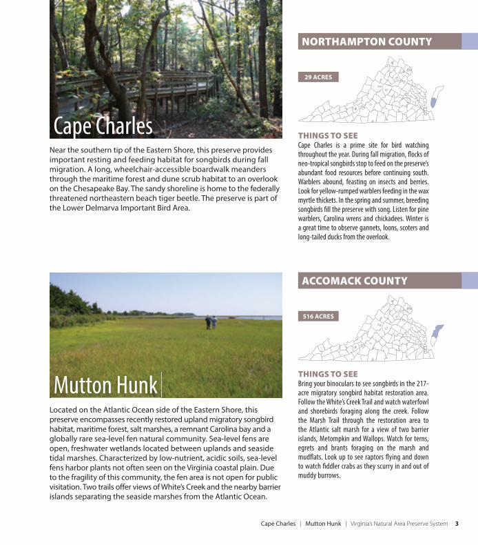
Near the southern tip of the Eastern Shore, this preserve provides important resting and feeding habitat for songbirds during fall migration. A long, wheelchair-accessible boardwalk meanders through the maritime forest and dune scrub habitat to an overlook on the Chesapeake Bay. The sandy shoreline is home to the federally threatened northeastern beach tiger beetle. The preserve is part of the Lower Delmarva Important Bird Area.
Cape Charles
4 Virginia’s Natural Area Preserve System | Savage Neck Dunes |
THINGS TO SEE Visitors can see some of the highest and best developed sand dunes in Virginia. The maritime forest and dune woodland contain native coastal tree, shrub and fl ower species. Look for post oaks, water oaks, sassafras, blueberries and pink lady’s-slipper orchids. Listen for spring peepers, green tree frogs and cricket frogs. Notice painted turtles sunning on logs and dragonfl ies feeding around the ponds. Follow the 0.75-mile Beach Trail through the forest and dunes to the Chesapeake Bay. In late summer and fall, look for monarchs and other butterfl ies gathering nectar on seaside goldenrod. Walk the shoreline and watch foraging sandpipers, terns, pelicans and scurrying ghost crabs.
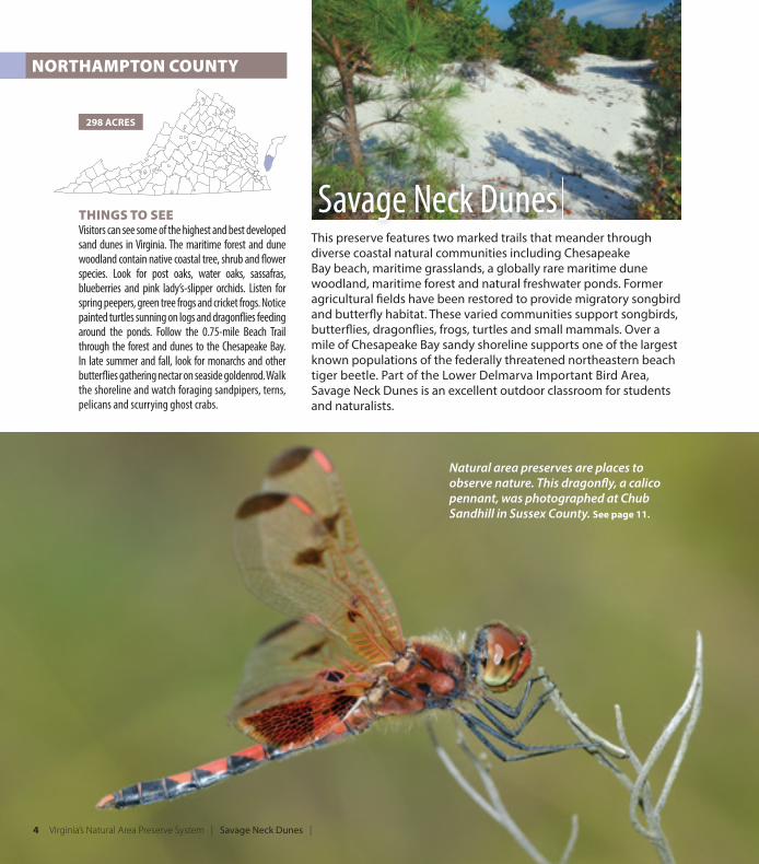
This preserve features two marked trails that meander through diverse coastal natural communities including Chesapeake Bay beach, maritime grasslands, a globally rare maritime dune woodland, maritime forest and natural freshwater ponds. Former agricultural fi elds have been restored to provide migratory songbird and butterfl y habitat. These varied communities support songbirds, butterfl ies, dragonfl ies, frogs, turtles and small mammals. Over a mile of Chesapeake Bay sandy shoreline supports one of the largest known populations of the federally threatened northeastern beach tiger beetle. Part of the Lower Delmarva Important Bird Area, Savage Neck Dunes is an excellent outdoor classroom for students and naturalists.
298 ACRES
NORTHAMPTON COUNTY
Savage Neck Dunes
Natural area preserves are places to observe nature. This dragonfl y, a calico pennant, was photographed at Chub Sandhill in Sussex County. See page 11.
Magothy Bay | Cumberland Marsh | Virginia’s Natural Area Preserve System 5
THINGS TO SEE A wheelchair-accessible boardwalk and observation deck look over the tidal freshwater marsh. A separate 1.5-mile trail leads along a tidal creek, around a restored wetland and through upland mixed pine-hardwood forests. Trails range from easy to moderate. The birding at this preserve can be phenomenal. Spring and fall are good times to see migratory songbirds, while late fall and winter bring excellent opportunities to spot waterfowl.
HOURS Open year-round from dawn to dusk.
1,193 ACRES
NEW KENT COUNTY
This preserve, a mixture of freshwater tidal marsh and wooded upland along the tidal Pamunkey River, provides pristine habitat for wetland species and migrating waterfowl. Cumberland Marsh supports one of the world’s largest populations of the endangered plant, sensitive joint-vetch. An observation deck on the marsh and extensive woodland trails provide opportunities to view a wide variety of bird species including bald eagles. This preserve is owned and managed by The Nature Conservancy in partnership with DCR.
Cumberland Marsh
NORTHAMPTON COUNTY
286 ACRES
THINGS TO SEE A 3-mile trail leads through the migratory songbird habitat restoration area into maritime forest and onto an old dike overlooking the salt marsh, barrier islands and Atlantic Ocean. The return loop trail crosses into the Eastern Shore of Virginia National Wildlife Refuge. Look for warblers and other migratory songbirds, as well as year-round resident birds. Listen for northern bobwhites and look overhead for northern harriers, Cooper’s hawks, bald eagles and American kestrels. In fall, look for bright red glasswort growing in the saltpans of the salt marsh.
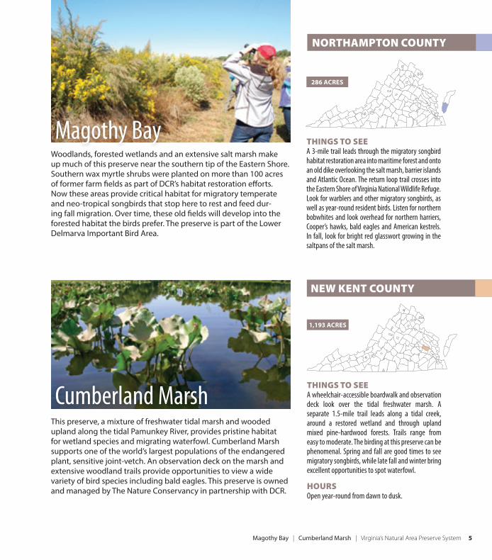
Woodlands, forested wetlands and an extensive salt marsh make up much of this preserve near the southern tip of the Eastern Shore. Southern wax myrtle shrubs were planted on more than 100 acres of former farm fi elds as part of DCR’s habitat restoration eff orts. Now these areas provide critical habitat for migratory temperate and neo-tropical songbirds that stop here to rest and feed dur-ing fall migration. Over time, these old fi elds will develop into the forested habitat the birds prefer. The preserve is part of the Lower Delmarva Important Bird Area.
Magothy Bay
6 Virginia’s Natural Area Preserve System | North Landing River | Bethel Beach
This preserve has a sandy Chesapeake Bay shoreline, low dunes and salt marsh. The shoreline habitat is home to the federally threatened northeastern beach tiger beetle. Please help protect habitat for this rare animal and prevent sand disturbance (digging) by children and your leashed dogs.
THINGS TO SEE The birding at Bethel Beach can be spectacular in any season. Almost 175 species of birds have been observed here. Summer brings views of the least tern. Tundra swans and other waterfowl can be seen in the winter. Numerous shorebird species frequent the preserve throughout the year but are most diverse during spring and fall migration.
HOURSBethel Beach is open from sunrise to sunset. However, the southern end of the preserve may be closed during the least tern nesting season, from May 1 through Sept. 15.
105 ACRES
MATHEWS COUNTY
Bethel Beach
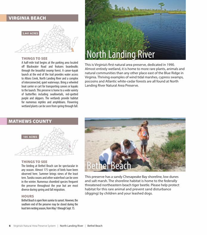
This is Virginia’s fi rst natural area preserve, dedicated in 1990. Almost entirely wetland, it is home to more rare plants, animals and natural communities than any other place east of the Blue Ridge in Virginia. Thriving examples of wind tidal marshes, cypress swamps, pocosins and Atlantic white-cedar forests are all found at North Landing River Natural Area Preserve.
THINGS TO SEE A half-mile trail begins at the parking area located off Blackwater Road and features boardwalks through the beautiful swamp forest. A canoe-kayak launch at the end of the trail provides water access to Altons Creek, North Landing River and a complex of interconnected, quiet waterways. Bring a wheeled boat carrier or cart for transporting canoes or kayaks to the launch. This preserve is home to a wide variety of butterfl ies including swallowtails, red-spotted purple and skippers. The wetlands provide habitat for numerous reptiles and amphibians. Flowering wetland plants can be seen from spring through fall.
3,441 ACRES
VIRGINIA BEACH
North Landing River
New Point Comfort | Bush Mill Stream | Virginia’s Natural Area Preserve System 7
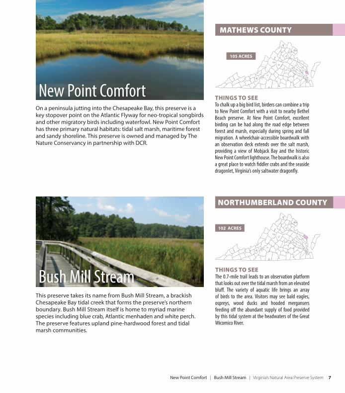
This preserve takes its name from Bush Mill Stream, a brackish Chesapeake Bay tidal creek that forms the preserve’s northern boundary. Bush Mill Stream itself is home to myriad marine species including blue crab, Atlantic menhaden and white perch. The preserve features upland pine-hardwood forest and tidal marsh communities.
THINGS TO SEE The 0.7-mile trail leads to an observation platform that looks out over the tidal marsh from an elevated bluff . The variety of aquatic life brings an array of birds to the area. Visitors may see bald eagles, ospreys, wood ducks and hooded mergansers feeding off the abundant supply of food provided by this tidal system at the headwaters of the Great Wicomico River.
102 ACRES
NORTHUMBERLAND COUNTY
Bush Mill Stream
THINGS TO SEE To chalk up a big bird list, birders can combine a trip to New Point Comfort with a visit to nearby Bethel Beach preserve. At New Point Comfort, excellent birding can be had along the road edge between forest and marsh, especially during spring and fall migration. A wheelchair-accessible boardwalk with an observation deck extends over the salt marsh, providing a view of Mobjack Bay and the historic New Point Comfort lighthouse. The boardwalk is also a great place to watch fi ddler crabs and the seaside dragonlet, Virginia’s only saltwater dragonfl y.
105 ACRES
MATHEWS COUNTY
On a peninsula jutting into the Chesapeake Bay, this preserve is a key stopover point on the Atlantic Flyway for neo-tropical songbirds and other migratory birds including waterfowl. New Point Comfort has three primary natural habitats: tidal salt marsh, maritime forest and sandy shoreline. This preserve is owned and managed by The Nature Conservancy in partnership with DCR.
New Point Comfort
8 Virginia’s Natural Area Preserve System | Dameron Marsh
THINGS TO SEE From the parking area, a 0.25-mile trail leads through old-fi eld succession forest and shrub thickets to a viewing platform overlooking the marsh and Chesapeake Bay. To the west of the parking area is a canoe-kayak launch. The hand-carry drop-off point is an easy, 100-yard portage from Mill Creek, with Ingram Bay a short paddle away.
Canada geese, tundra swans and diving ducks can be seen during winter. In the spring and summer, biting fl ies are pervasive so some visitors prefer to visit during the cooler months. Download a brochure for a self-guided tour at www.dcr.virginia.gov/natural-heritage/natural-area-preserves/dameron.
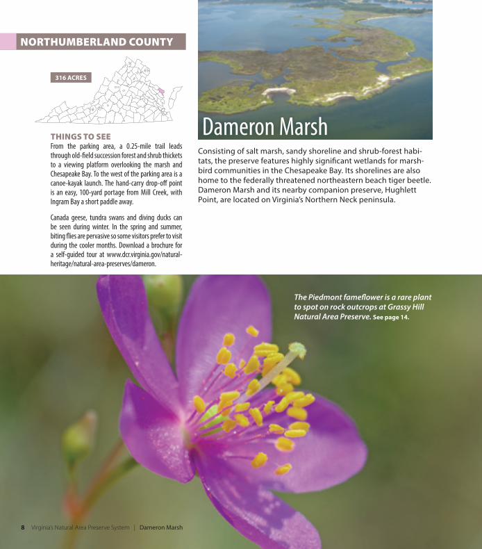
Consisting of salt marsh, sandy shoreline and shrub-forest habi-tats, the preserve features highly signifi cant wetlands for marsh-bird communities in the Chesapeake Bay. Its shorelines are also home to the federally threatened northeastern beach tiger beetle. Dameron Marsh and its nearby companion preserve, Hughlett Point, are located on Virginia’s Northern Neck peninsula.
316 ACRES
NORTHUMBERLAND COUNTY
Dameron Marsh
The Piedmont famefl ower is a rare plant to spot on rock outcrops at Grassy Hill Natural Area Preserve. See page 14.
Hughlett Point | Hickory Hollow | Virginia’s Natural Area Preserve System 9
LANCASTER COUNTY
254 ACRES
THINGS TO SEE This is a great preserve for a longer hike as it features over 4 miles of trails, enabling you to walk through beautiful, quiet Northern Neck forestlands. Summer rains bring mushrooms and woodland orchids. Bring a picnic lunch or snacks and rest in the small shelter near the parking area.
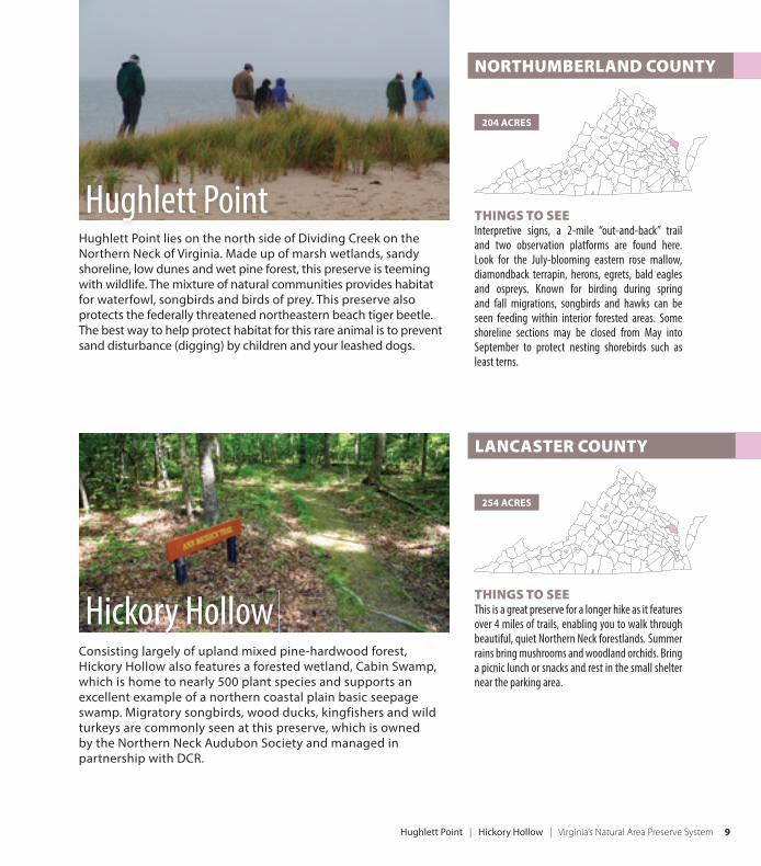
Consisting largely of upland mixed pine-hardwood forest, Hickory Hollow also features a forested wetland, Cabin Swamp, which is home to nearly 500 plant species and supports an excellent example of a northern coastal plain basic seepage swamp. Migratory songbirds, wood ducks, kingfishers and wild turkeys are commonly seen at this preserve, which is owned by the Northern Neck Audubon Society and managed in partnership with DCR.
Hickory Hollow
THINGS TO SEE Interpretive signs, a 2-mile “out-and-back” trail and two observation platforms are found here. Look for the July-blooming eastern rose mallow, diamondback terrapin, herons, egrets, bald eagles and ospreys. Known for birding during spring and fall migrations, songbirds and hawks can be seen feeding within interior forested areas. Some shoreline sections may be closed from May into September to protect nesting shorebirds such as least terns.
Hughlett Point lies on the north side of Dividing Creek on the Northern Neck of Virginia. Made up of marsh wetlands, sandy shoreline, low dunes and wet pine forest, this preserve is teeming with wildlife. The mixture of natural communities provides habitat for waterfowl, songbirds and birds of prey. This preserve also protects the federally threatened northeastern beach tiger beetle. The best way to help protect habitat for this rare animal is to prevent sand disturbance (digging) by children and your leashed dogs.
204 ACRES
NORTHUMBERLAND COUNTY
Hughlett Point
10 Virginia’s Natural Area Preserve System | Crow’s Nest
THINGS TO SEE The preserve is home to nesting bald eagles and more than 60 species of neo-tropical songbirds. A trail begins at the Brooke Road parking area and heads east to scenic overlooks on Accokeek Creek. The Crow’s Nest Water Trail also starts at the Brooke Road parking area and features a canoe-kayak launch that complies with Americans with Disabilities Act guidelines. The Crow’s Nest Peninsula access point off Raven Road aff ords parking and trailhead access to an extensive system of trails. Many visitors choose to experience this preserve during the spring and fall to see migratory birds and avoid the abundant ticks, chiggers and biting fl ies of summer.
HOURSThe Crow’s Nest Peninsula access point is closed Monday through Wednesday and on days designated for managed waterfowl hunts. Before visiting check www.dcr.virginia.gov/natural-heritage/natural-area-preserves/crowsnest.
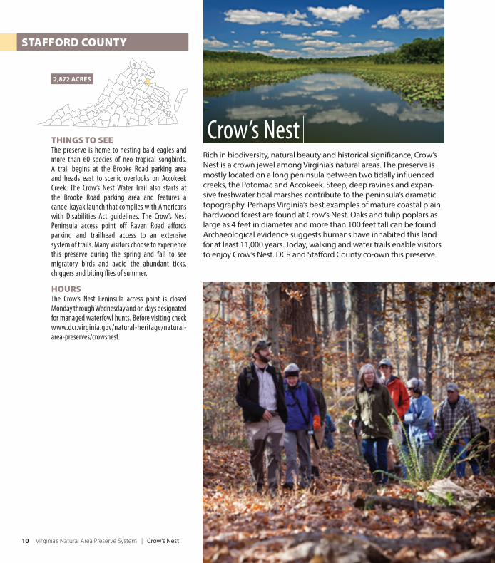
Rich in biodiversity, natural beauty and historical signifi cance, Crow’s Nest is a crown jewel among Virginia’s natural areas. The preserve is mostly located on a long peninsula between two tidally infl uenced creeks, the Potomac and Accokeek. Steep, deep ravines and expan-sive freshwater tidal marshes contribute to the peninsula’s dramatic topography. Perhaps Virginia’s best examples of mature coastal plain hardwood forest are found at Crow’s Nest. Oaks and tulip poplars as large as 4 feet in diameter and more than 100 feet tall can be found. Archaeological evidence suggests humans have inhabited this land for at least 11,000 years. Today, walking and water trails enable visitors to enjoy Crow’s Nest. DCR and Staff ord County co-own this preserve.
2,872 ACRES
STAFFORD COUNTY
Crow’s Nest
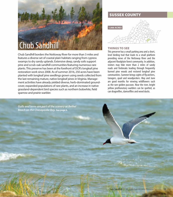
Chub Sandhill | Virginia’s Natural Area Preserve System 11
THINGS TO SEE This preserve has a small parking area and a short, level birding trail that leads to a small platform providing views of the Nottoway River and the adjacent fl oodplain forest community. In addition, visitors may hike more than 2 miles of sandy roads and fi rebreaks leading through frequently burned pine woods and restored longleaf pine communities. Summer brings sights of fl ycatchers, tanagers, quail and woodpeckers. May and June are good months for viewing wildfl owers such as the rare golden puccoon. Near the river, bright yellow prothonotary warblers can be spotted, as can dragonfl ies, damselfl ies and wood ducks.
Chub Sandhill borders the Nottoway River for more than 3 miles and features a diverse set of coastal plain habitats ranging from cypress swamps to dry sandy uplands. Extensive deep, sandy soils support pine and scrub-oak sandhill communities featuring numerous rare plants. This preserve has been at the forefront of DCR’s longleaf pine restoration work since 2008. As of summer 2016, 250 acres have been planted with longleaf pine seedlings grown using seeds collected from the last remaining mature, native longleaf pines in Virginia. Manage-ment activities have already yielded diverse, herb-dominated ground-cover, expanded populations of rare plants, and an increase in native grassland-dependent bird species such as northern bobwhite, fi eld sparrow and prairie warbler.
1,066 ACRES
SUSSEX COUNTY
Chub Sandhill
Gulls and terns are part of the scenery at Bethel Beach on the Chesapeake Bay. See page 6.
12 Virginia’s Natural Area Preserve System | Goshen Pass
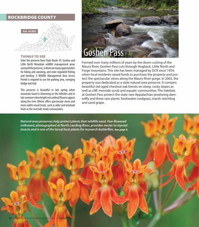
ROCKBRIDGE COUNTY
THINGS TO SEE Enter the preserve from State Route 39. Goshen and Little North Mountain wildlife management areas surround the preserve, so there are many opportunities for hiking and canoeing, and state-regulated fi shing and hunting. A Wildlife Management Area Access Permit is required to use the parking area, swinging bridge and trail.
This preserve is beautiful in late spring when mountain laurel is blooming on the hillsides and in late summer when bright red cardinal fl owers appear along the river. Winter off ers spectacular views and more subtle visual treats, such as alder and ninebark fruits in the riverside shrub communities.
936 ACRES
Formed over many millions of years by the down-cutting of the Maury River, Goshen Pass cuts through Hogback, Little North and Forge mountains. This site has been managed by DCR since 1954, when local residents raised funds to purchase the property and pro-tect the spectacular views along the Maury River gorge. In 2002, the property was dedicated as a state natural area preserve. It contains beautiful old-aged chestnut oak forests on steep, rocky slopes as well as cliff , riverside scrub and aquatic communities. The habitats at Goshen Pass protect the state-rare Appalachian jewelwing dam-selfl y and three rare plants: freshwater cordgrass, marsh vetchling and sand grape.
Goshen Pass
Natural area preserves help protect plants that wildlife need. Few-fl owered milkweed, photographed at North Landing River, provides nectar to myriad insects and is one of the larval host plants for monarch butterfl ies. See page 6.
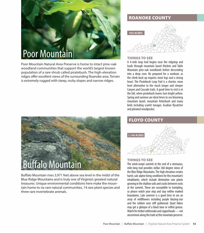
Poor Mountain | Buff alo Mountain | Virginia’s Natural Area Preserve System 13
THINGS TO SEE The wind-swept summit at the end of a strenuous, mile-long trail provides stellar 360-degree views of the Blue Ridge Mountains. The high elevation creates harsh, sub-alpine living conditions for this mountain’s inhabitants, which include diminutive rare plants growing in the shallow soils and cracks between rocks at the summit. These are susceptible to trampling, so please watch your step and stay within marked boundaries. Late summer is a good time to see an array of wildfl owers including purple blazing-star and the seldom seen stiff goldenrod. Quiet hikers may get a glimpse of a black bear or ruff ed grouse. Watch for timber rattlesnake and copperheads — not uncommon along the trails at this mountain preserve.
Buff alo Mountain rises 3,971 feet above sea level in the midst of the Blue Ridge Mountains and is truly one of Virginia’s greatest natural treasures. Unique environmental conditions here make the moun-tain home to six rare natural communities, 14 rare plant species and three rare invertebrate animals.
1,140 ACRES
FLOYD COUNTY
Buff alo Mountain
THINGS TO SEE A 4-mile loop trail begins near the ridgetop and leads through mountain laurel thickets and Table Mountain pine-oak woodlands before descending into a deep cove. Be prepared for a workout, as the climb back up requires stout legs and a strong heart. The Piratebush Loop Trail is a shorter, more level alternative to the much longer and steeper Canyon and Cascade trails. A good time to visit is in the fall, when piratebush leaves turn bright yellow. Spring and summer are ideal times to see blooming mountain laurel, mountain fetterbush and many birds including scarlet tanager, Acadian fl ycatcher and pileated woodpecker.
ROANOKE COUNTY
932 ACRES
Poor Mountain Natural Area Preserve is home to intact pine-oak woodland communities that support the world’s largest known population of a rare shrub called piratebush. The high-elevation ridges off er excellent views of the surrounding Roanoke area. Terrain is extremely rugged with steep, rocky slopes and narrow ridges.
Poor Mountain
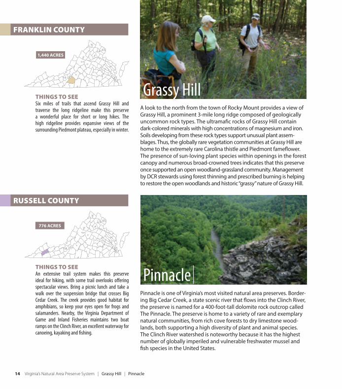
14 Virginia’s Natural Area Preserve System | Grassy Hill | Pinnacle
THINGS TO SEE An extensive trail system makes this preserve ideal for hiking, with some trail overlooks off ering spectacular views. Bring a picnic lunch and take a walk over the suspension bridge that crosses Big Cedar Creek. The creek provides good habitat for amphibians, so keep your eyes open for frogs and salamanders. Nearby, the Virginia Department of Game and Inland Fisheries maintains two boat ramps on the Clinch River, an excellent waterway for canoeing, kayaking and fi shing.
Pinnacle is one of Virginia’s most visited natural area preserves. Border-ing Big Cedar Creek, a state scenic river that fl ows into the Clinch River, the preserve is named for a 400-foot-tall dolomite rock outcrop called The Pinnacle. The preserve is home to a variety of rare and exemplary natural communities, from rich cove forests to dry limestone wood-lands, both supporting a high diversity of plant and animal species. The Clinch River watershed is noteworthy because it has the highest number of globally imperiled and vulnerable freshwater mussel and fi sh species in the United States.
776 ACRES
Pinnacle
THINGS TO SEE Six miles of trails that ascend Grassy Hill and traverse the long ridgeline make this preserve a wonderful place for short or long hikes. The high ridgeline provides expansive views of the surrounding Piedmont plateau, especially in winter.
1,440 ACRES
FRANKLIN COUNTY
RUSSELL COUNTY
A look to the north from the town of Rocky Mount provides a view of Grassy Hill, a prominent 3-mile long ridge composed of geologically uncommon rock types. The ultramafi c rocks of Grassy Hill contain dark-colored minerals with high concentrations of magnesium and iron. Soils developing from these rock types support unusual plant assem-blages. Thus, the globally rare vegetation communities at Grassy Hill are home to the extremely rare Carolina thistle and Piedmont famefl ower. The presence of sun-loving plant species within openings in the forest canopy and numerous broad-crowned trees indicates that this preserve once supported an open woodland-grassland community. Management by DCR stewards using forest thinning and prescribed burning is helping to restore the open woodlands and historic “grassy” nature of Grassy Hill.
Grassy Hill
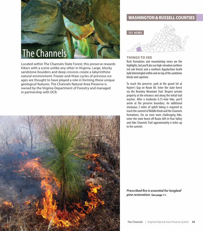
The Channels | Virginia’s Natural Area Preserve System 15
THINGS TO SEE Rock formations and mountaintop views are the highlights, but you’ll also see high-elevation northern red oak forests and a southern Appalachian heath bald intermingled within and on top of the sandstone blocks and capstone.
To reach the preserve, park at the gravel lot at Hayter’s Gap on Route 80. Enter the state forest via the Brumley Mountain Trail. Respect private property at the entrance and along the initial trail reaches. After a moderate 0.75-mile hike, you’ll arrive at the preserve boundary. An additional strenuous 2 miles of uphill hiking is required to reach the summit of Middle Knob and the Channels formations. For an even more challenging hike, enter the state forest off Route 689 in Poor Valley and hike Channels Trail approximately 6 miles up to the summit.
Located within The Channels State Forest, this preserve rewards hikers with a scene unlike any other in Virginia. Large, blocky sandstone boulders and deep crevices create a labyrinthine natural environment. Freeze-and-thaw cycles of previous ice ages are thought to have played a role in forming these unique geological features. The Channels Natural Area Preserve is owned by the Virginia Department of Forestry and managed in partnership with DCR.
721 ACRES
WASHINGTON & RUSSELL COUNTIES
The Channels
Prescribed fi re is essential for longleaf pine restoration. See page 11.
16 Virginia’s Natural Area Preserve System
Established in 1989, Virginia’s Natural Area Preserve System protects some of the best examples of natural communities and rare plant and animal habitats in Virginia and the world. The first preserve, North Landing River Natural Area Preserve in Virginia Beach, was dedicated in 1990. The preserve system took just 17 years to reach the 50-preserve milestone, and the program continues to grow. Most preserves in the system are owned by the Virginia Department of Conservation and Recreation; however, some are owned by local governments, universities, The Nature Conservancy and other private landowners.
When property is dedicated as a state natural area preserve, the site is permanently protected by placing legally binding restrictions on future activities and development. The primary objectives are to retain and enhance populations of rare plant and animal species and to protect and maintain the best examples of Virginia’s natural communities. Thus, Virginia’s system of natural area preserves protects common native species as well as rare plants and animals. This approach to resource stewardship is perhaps the most valuable form of conservation because it protects Virginia’s most threatened, treasured and ecologically significant places and life-forms.
NATURAL HERITAGE PROGRAMState natural area preserves are managed under DCR’s Virginia Natural Heritage Program, which started in 1986. Through inventory, data management, protection and stewardship, Virginia’s biodiversity is better understood and conserved by the program. Scientists, information managers, resource managers and an extensive conservation
information system are the foundation upon which the natural area preserve system is built and managed. Natural Heritage staff also provides land conservation and planning information to the public to help individuals, organizations and companies make well-informed land conservation and land-use decisions.
The Virginia Natural Heritage Program is a member of NatureServe, a nonprofit conservation organization that, along with its network of natural heritage programs in the Americas, is the leading source for information about rare and endangered species and threatened ecosystems. As a member of NatureServe, Virginia benefits by having ready access to global data; contributes to the study of global biodiversity; and provides for the conservation and recovery of Earth’s native ecosystems and rare and endangered species.
STEWARDSHIPTo manage the preserves and maintain rare resources while also providing visitor access, DCR employs a team of regionally based natural area stewards. Stewards actively manage the preserves by controlling invasive species, conducting prescribed burns, monitoring rare species populations, and designing and maintaining appropriate public access facilities. This active management approach is needed to protect, enhance and restore natural communities and rare species habitat. Many dedicated volunteers play a critical role in the stewardship of the preserves. DCR staff members also advise other landowners about techniques and methods for managing natural areas.
Natural Area Preserves
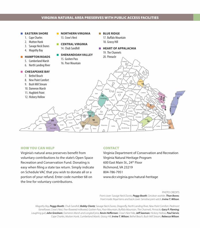
HOW YOU CAN HELPVirginia’s natural area preserves benefit from voluntary contributions to the state’s Open Space Recreation and Conservation Fund. Donating is easy when filing a state tax return. Simply indicate on Schedule VAC that you wish to donate all or a portion of your refund. Enter code number 68 on the line for voluntary contributions.
Lee
VIRGINIA NATURAL AREA PRESERVES WITH PUBLIC ACCESS FACILITIES
EASTERN SHORE1. Cape Charles2. Mutton Hunk 3. Savage Neck Dunes4. Magothy Bay
HAMPTON ROADS5. Cumberland Marsh6. North Landing River
CHESAPEAKE BAY7. Bethel Beach8. New Point Comfort9. Bush Mill Stream10. Dameron Marsh11. Hughlett Point12. Hickory Hollow
NORTHERN VIRGINIA13. Crow’s Nest
CENTRAL VIRGINIA14. Chub Sandhill
SHENANDOAH VALLEY15. Goshen Pass16. Poor Mountain
BLUE RIDGE17. Buffalo Mountain18. Grassy Hill
HEART OF APPALACHIA19. The Channels20. Pinnacle
CONTACTVirginia Department of Conservation and RecreationVirginia Natural Heritage Program600 East Main St., 24th FloorRichmond, VA 23219804-786-7951www.dcr.virginia.gov/natural-heritage
PHOTO CREDITS Front cover: Savage Neck Dunes, Peggy Booth; Cerulean warbler, Than Boves; Front inside: Royal terns and back cover: Sensitive joint-vetch, Irvine T. Wilson.
Magothy Bay, Peggy Booth; Chub Sandhill, Bobby Clontz; Savage Neck Dunes, Dragonfly, North Landing River, New Point Comfort, Piedmont fameflower, Crow’s Nest, Few-flowered milkweed, Goshen Pass, Poor Mountain, Buffalo Mountain, The Channels, Pinnacle, Gary P. Fleming;
Laughing gull, John Gresham; Dameron Marsh and Longleaf pine, Kevin Heffernan; Crow’s Nest hike, Jeff Saxman; Hickory Hollow, Paul Servis; Cape Charles, Mutton Hunk, Cumberland Marsh, Grassy Hill, Irvine T. Wilson; Bethel Beach, Bush Mill Stream, Rebecca Wilson.
Virginia Natural Heritage Programwww.dcr.virginia.gov/natural-heritage804-786-7951 October 2016