vi. wildlife - a123.g.akamai.neta123.g.akamai.net/7/123/11558/abc123/forestservic... · for...
TRANSCRIPT
Middle Fork Fuels Reduction Project Chapter 3 – Wildlife
3-67
VI. WILDLIFE
Introduction The Middle Fork Fuels Reduction (MFFR) Project proposes to apply forest management practices on wildlife habitat contained within the Middle Fork of the Flathead River drainage; the specific location and details of the MFFR Project Area are described in chapter 2. Effects of proposed treatments on wildlife and their habitat are evaluated for alternative 1 and alternative 2.
Information Sources
Site-specific information on habitat values and suitability for various wildlife species was collected from on-site visits for most proposed treatment units during multiple seasons in 2007, 2008, and 2009. Existing stand examination data, aerial photo interpretation, and descriptions by the silviculturist were also used for analysis. The VMAP vegetation coverage and 2005 National Agricultural Imagery Program (NAIP) images were used to classify various habitat characteristics for habitat modeling. The ArcMap geographical information system (GIS) was used for modeling, mapping and quantification. Research literature, comments, and data files from the Montana Department of Fish, Wildlife and Parks (MDFWP) were used for species information. Information compiled by the Great Northern Environmental Stewardship Area cooperators (GNESA 2008) was used for analysis along the Highway 2 corridor.
Analysis Area Description
The Middle Fork Fuels Reduction (MFFR) Project Area is a large area of nearly 32,000 acres crossing multiple watersheds. It extends over 30 miles along the Middle Fork Flathead River, from Moccasin Creek on the west side to Geifer Creek on the east. It encompasses National Forest, private and State lands sandwiched between the Great Bear Wilderness (GBW) and Glacier National Park (GNP). The MFFR Project Area serves as an important wildlife link between GNP and wilderness lands to the south. No hunting or trapping of wildlife is allowed in GNP and although it is allowed in the wilderness areas, the lack of motorized access routes makes it difficult, lowering success rates. The wilderness portion of the Middle Fork comprises a significant portion of the Middle Fork Flathead River drainage. Here, natural processes (fire, wind, floods, insects/disease, etc.) are the primary habitat change agents. Fire has been the most common disturbance factor in the project area influencing the forest vegetation (refer to Fire and Fuels section of this chapter, and section L2 in the project file for locations of past fires). Past timber harvest has been the other primary disturbance factor (refer the Vegetation section of chapter 3). About 725 acres of prescribed burning occurred in the project area in 1988 and 1991. These burns occurred in the open meadows in the Nyack Flats area and on the more open slopes on the south aspects of Paola Creek. They were of low to moderate intensity and designed
Middle Fork Fuels Reduction Project Chapter 3 – Wildlife
3-68
primarily to retain or increase open forest conditions and stimulate browse production for wildlife foraging. Infestations by mountain pine beetle and Douglas-fir beetle also occur in the project area (see Vegetation section of chapter 3).
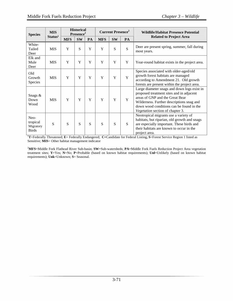
Wildlife Species/Habitat Selection Process for Effects Analysis The Middle Fork drainage provides a diverse collection of wildlife habitats necessary for the recovery of Threatened and Endangered species (grizzly bear and Canada lynx) as well as habitat for ungulates including white-tailed deer, mule deer, elk, mountain goats, and moose. Many other mammal, bird, and amphibian species known to occur on the Flathead National Forest also occur in the area (see Table 3-23). The Flathead Forest Plan lists as Management Indicator Species (MIS) all Threatened, Endangered, and Sensitive species, elk, mule deer, and white-tailed deer. However, not all wildlife MIS that occupy habitats within the Middle Fork would be affected by alternative 2. The MIS that could be impacted by the proposed Middle Fork Fuels Reduction Project were evaluated using the historical and current MIS distributions at the sub-basin, sub-watershed, and project area scales (Table 3-23). Two criteria were used for determining which MIS to eliminate from further analyses: 1) habitat is absent in the project analysis area or 2) individuals or potentially suitable habitat would not be affected by the proposed project to a degree warranting in-depth analysis (Tables 3-24). For some species meeting the second criteria, some minor potential impacts may be possible, as described in Table 3-24. The remaining MIS were then carried forward into the effects analysis, with species-specific indicators used to determine potential effects to the species and/or habitat.
Middle Fork Fuels Reduction Project Chapter 3 – Wildlife
3-69
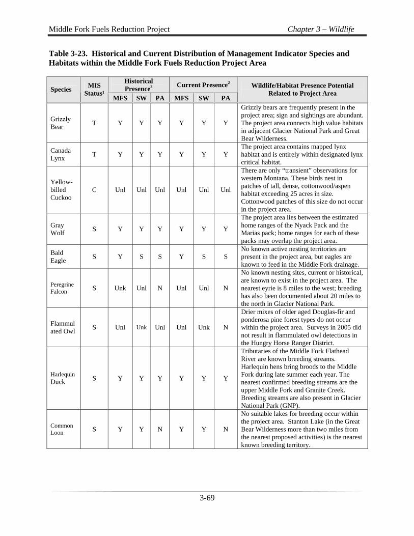
Table 3-23. Historical and Current Distribution of Management Indicator Species and Habitats within the Middle Fork Fuels Reduction Project Area
Historical Presence2
Current Presence2 Species
MIS Status¹
MFS SW PA MFS SW PA
Wildlife/Habitat Presence Potential Related to Project Area
Grizzly Bear
T Y Y Y Y Y Y
Grizzly bears are frequently present in the project area; sign and sightings are abundant. The project area connects high value habitats in adjacent Glacier National Park and Great Bear Wilderness.
Canada Lynx
T Y Y Y Y Y Y The project area contains mapped lynx habitat and is entirely within designated lynx critical habitat.
Yellow-billed Cuckoo
C Unl Unl Unl Unl Unl Unl
There are only “transient” observations for western Montana. These birds nest in patches of tall, dense, cottonwood/aspen habitat exceeding 25 acres in size. Cottonwood patches of this size do not occur in the project area.
Gray Wolf
S Y Y Y Y Y Y
The project area lies between the estimated home ranges of the Nyack Pack and the Marias pack; home ranges for each of these packs may overlap the project area.
Bald Eagle
S Y S S Y S S No known active nesting territories are present in the project area, but eagles are known to feed in the Middle Fork drainage.
Peregrine Falcon S Unk Unl N Unl Unl N
No known nesting sites, current or historical, are known to exist in the project area. The nearest eyrie is 8 miles to the west; breeding has also been documented about 20 miles to the north in Glacier National Park.
Flammulated Owl
S Unl Unk Unl Unl Unk N
Drier mixes of older aged Douglas-fir and ponderosa pine forest types do not occur within the project area. Surveys in 2005 did not result in flammulated owl detections in the Hungry Horse Ranger District.
Harlequin Duck S Y Y Y Y Y Y
Tributaries of the Middle Fork Flathead River are known breeding streams. Harlequin hens bring broods to the Middle Fork during late summer each year. The nearest confirmed breeding streams are the upper Middle Fork and Granite Creek. Breeding streams are also present in Glacier National Park (GNP).
Common Loon S Y Y N Y Y N
No suitable lakes for breeding occur within the project area. Stanton Lake (in the Great Bear Wilderness more than two miles from the nearest proposed activities) is the nearest known breeding territory.
Middle Fork Fuels Reduction Project Chapter 3 – Wildlife
3-70
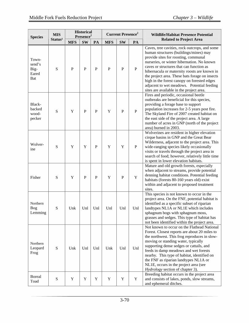
Historical Presence2
Current Presence2 Species
MIS Status¹
MFS SW PA MFS SW PA
Wildlife/Habitat Presence Potential Related to Project Area
Town-send’s Big-Eared Bat
S P P P P P P
Caves, tree cavities, rock outcrops, and some human structures (buildings/mines) may provide sites for roosting, communal nurseries, or winter hibernation. No known caves or structures that can function as hibernacula or maternity roosts are known in the project area. These bats forage on insects high in the forest canopy on forested edges adjacent to wet meadows. Potential feeding sites are available in the project area.
Black-backed wood-pecker
S Y P P Y P P
Fires and periodic, occasional beetle outbreaks are beneficial for this species, providing a forage base to support population increases for 2-5 years post fire. The Skyland Fire of 2007 created habitat on the east side of the project area. A large number of acres in GNP (north of the project area) burned in 2003.
Wolver-ine
S Y Y P Y Y P
Wolverines are resident in higher elevation cirque basins in GNP and the Great Bear Wilderness, adjacent to the project area. This wide-ranging species likely occasionally visits or travels through the project area in search of food; however, relatively little time is spent in lower elevation habitats.
Fisher S Y P P Y P Y
Mature and old growth forests, especially when adjacent to streams, provide potential denning habitat conditions. Potential feeding habitats (forests 80-160 years old) exist within and adjacent to proposed treatment sites.
Northern Bog Lemming
S Unk Unl Unl Unl Unl Unl
This species is not known to occur in the project area. On the FNF, potential habitat is identified as a specific subset of riparian landtypes NL1A or NL1E which includes sphagnum bogs with sphagnum moss, grasses and sedges. This type of habitat has not been identified within the project area.
Northern Leopard Frog
S Unk Unl Unl Unk Unl Unl
Not known to occur on the Flathead National Forest. Closest reports are about 20 miles to the northwest. This frog reproduces in slow-moving or standing water, typically supporting dense sedges or cattails, and feeds in damp meadows and wet forests nearby. This type of habitat, identified on the FNF as riparian landtypes NL1A or NL1E, occurs in the project area (see Hydrology section of chapter 3).
Boreal Toad
S Y Y Y Y Y Y Breeding habitat occurs in the project area and consists of lakes, ponds, slow streams, and ephemeral ditches.
Middle Fork Fuels Reduction Project Chapter 3 – Wildlife
3-71
Historical Presence2
Current Presence2 Species
MIS Status¹
MFS SW PA MFS SW PA
Wildlife/Habitat Presence Potential Related to Project Area
White-Tailed Deer
MIS Y S Y Y S S Deer are present spring, summer, fall during most years.
Elk and Mule Deer
MIS Y Y Y Y Y Y Year-round habitat exists in the project area.
Old Growth Species
MIS Y Y Y Y Y Y
Species associated with older-aged/old growth forest habitats are managed according to Amendment 21. Old growth forests are present within the project area.
Snags & Down Wood
MIS Y Y Y Y Y Y
Large diameter snags and down logs exist in proposed treatment sites and in adjacent areas of GNP and the Great Bear Wilderness. Further descriptions snag and down wood conditions can be found in the Vegetation section of chapter 3.
Neo-tropical Migratory Birds
S S S S S S S
Neotropical migrants use a variety of habitats, but riparian, old growth and snags are especially important. These birds and their habitats are known to occur in the project area.
1T=Federally Threatened; E= Federally Endangered; C=Candidate for Federal Listing, S=Forest Service Region 1 listed as Sensitive; MIS= Other habitat management indicator
2MFS=Middle Fork Flathead River Sub-basin; SW=Sub-watersheds; PA=Middle Fork Fuels Reduction Project Area vegetation treatment sites; Y=Yes; N=No; P=Probable (based on known habitat requirements); Unl=Unlikely (based on known habitat requirements); Unk=Unknown; S= Seasonal.
Middle Fork Fuels Reduction Project Chapter 3 – Wildlife
3-72
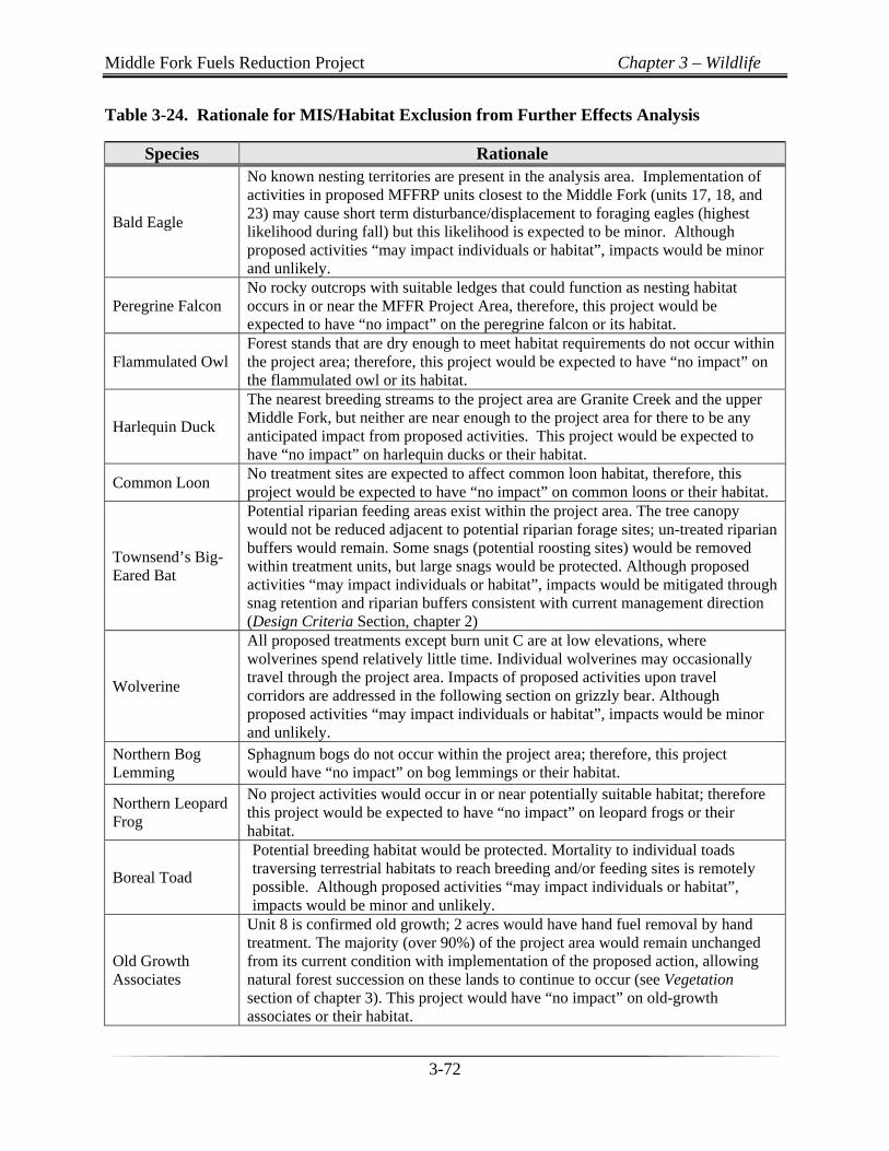
Table 3-24. Rationale for MIS/Habitat Exclusion from Further Effects Analysis
Species Rationale
Bald Eagle
No known nesting territories are present in the analysis area. Implementation of activities in proposed MFFRP units closest to the Middle Fork (units 17, 18, and 23) may cause short term disturbance/displacement to foraging eagles (highest likelihood during fall) but this likelihood is expected to be minor. Although proposed activities “may impact individuals or habitat”, impacts would be minor and unlikely.
Peregrine Falcon No rocky outcrops with suitable ledges that could function as nesting habitat occurs in or near the MFFR Project Area, therefore, this project would be expected to have “no impact” on the peregrine falcon or its habitat.
Flammulated Owl Forest stands that are dry enough to meet habitat requirements do not occur within the project area; therefore, this project would be expected to have “no impact” on the flammulated owl or its habitat.
Harlequin Duck
The nearest breeding streams to the project area are Granite Creek and the upper Middle Fork, but neither are near enough to the project area for there to be any anticipated impact from proposed activities. This project would be expected to have “no impact” on harlequin ducks or their habitat.
Common Loon No treatment sites are expected to affect common loon habitat, therefore, this project would be expected to have “no impact” on common loons or their habitat.
Townsend’s Big- Eared Bat
Potential riparian feeding areas exist within the project area. The tree canopy would not be reduced adjacent to potential riparian forage sites; un-treated riparian buffers would remain. Some snags (potential roosting sites) would be removed within treatment units, but large snags would be protected. Although proposed activities “may impact individuals or habitat”, impacts would be mitigated through snag retention and riparian buffers consistent with current management direction (Design Criteria Section, chapter 2)
Wolverine
All proposed treatments except burn unit C are at low elevations, where wolverines spend relatively little time. Individual wolverines may occasionally travel through the project area. Impacts of proposed activities upon travel corridors are addressed in the following section on grizzly bear. Although proposed activities “may impact individuals or habitat”, impacts would be minor and unlikely.
Northern Bog Lemming
Sphagnum bogs do not occur within the project area; therefore, this project would have “no impact” on bog lemmings or their habitat.
Northern Leopard Frog
No project activities would occur in or near potentially suitable habitat; therefore this project would be expected to have “no impact” on leopard frogs or their habitat.
Boreal Toad
Potential breeding habitat would be protected. Mortality to individual toads traversing terrestrial habitats to reach breeding and/or feeding sites is remotely possible. Although proposed activities “may impact individuals or habitat”, impacts would be minor and unlikely.
Old Growth Associates
Unit 8 is confirmed old growth; 2 acres would have hand fuel removal by hand treatment. The majority (over 90%) of the project area would remain unchanged from its current condition with implementation of the proposed action, allowing natural forest succession on these lands to continue to occur (see Vegetation section of chapter 3). This project would have “no impact” on old-growth associates or their habitat.
Middle Fork Fuels Reduction Project Chapter 3 – Wildlife
3-73
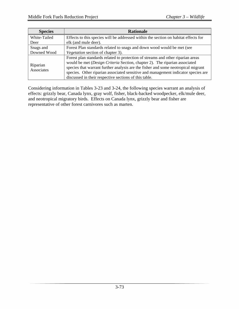
Species Rationale White-Tailed Deer
Effects to this species will be addressed within the section on habitat effects for elk (and mule deer).
Snags and Downed Wood
Forest Plan standards related to snags and down wood would be met (see Vegetation section of chapter 3).
Riparian Associates
Forest plan standards related to protection of streams and other riparian areas would be met (Design Criteria Section, chapter 2). The riparian associated species that warrant further analysis are the fisher and some neotropical migrant species. Other riparian associated sensitive and management indicator species are discussed in their respective sections of this table.
Considering information in Tables 3-23 and 3-24, the following species warrant an analysis of effects: grizzly bear, Canada lynx, gray wolf, fisher, black-backed woodpecker, elk/mule deer, and neotropical migratory birds. Effects on Canada lynx, grizzly bear and fisher are representative of other forest carnivores such as marten.
Middle Fork Fuels Reduction Project Chapter 3 – Grizzly Bear
3-74
Threatened and Endangered Wildlife
Grizzly Bear (Threatened)
Analysis Area The direct, indirect, and cumulative effects analysis area for grizzly bears for the proposed Middle Fork Fuels Reduction Project is made up of the five grizzly bear subunits that contain the project area (Map 3-1). A grizzly bear subunit is an area that approximates the size of a female home range (approximately 30-50 mi2) and is commonly used to analyze the status of habitat security for grizzly bears. Subunits on the Flathead National Forest were delineated to include seasonal and elevational habitat distribution, as recommended by the Interagency Grizzly Bear Committee (IGBC) (IGBC 1994). Although these delineations were recommended for evaluating motorized access effects to grizzly bears, they also represent an appropriate scale of analysis for many common activities on National Forest System lands, due to the habitat distributions and watershed areas they contain. Four of the subunits that were analyzed contain proposed project activities. An additional subunit is considered for cumulative effects in order to encompass the total proposed treatment area, from west to east along Highway 2.
Affected Environment/Existing Condition Population Status These five subunits are within the 5.7 million acre Northern Continental Divide Ecosystem (NCDE). The NCDE is thought to contain the largest population of grizzly bears in the lower 48 states. A United States Geological Survey (USGS) population estimate based on DNA sampling completed in 2004 was released in September of 2008. The minimum number of grizzly bears in the NCDE for 2004 was reported as 765 with a 95% confidence interval (CI) of 715 to 831 bears (Kendall et al. 2009). This method of estimating the population is more accurate than methods used in the 1993 Grizzly Bear Recovery Plan. Estimates of numbers of resident bears are not specifically available at the subunit level. Many radio-collared bears were located in the Middle Fork drainage during 2009 by Montana Department of Fish Wildlife and Parks (MDFWP) and Forest Service personnel. Radio-collared bears are frequently located in these five subunits in all seasons during MDFWP monitoring flights. There have been approximately 40 grizzly mortalities in the analysis area from 1980-2006. Grizzly bears are known to feed in avalanche chutes along the southern boundary of Glacier National Park (GNP) on a regular basis during the spring season. Grizzly bear train collisions have been documented in the area since 1976 and have been a significant source of mortality. Bears have been attracted to the railroad tracks by spills of grain and other substances as well as carcasses of other wildlife killed by trains (USDI 2006). During the ten year period from 1996-2006 there were 13 train related kills, 2 highway kills, 2 shot due to mistaken identity, 2 poached, and 2 food/garbage related mortalities (see section M2 in the project file).

Middle Fork Fuels Reduction Project Chapter 3 – Grizzly Bear
3-75
Middle Fork Fuels Reduction Project Chapter 3 – Grizzly Bear
3-76
Most of the land in each of the five subunits is in Forest Service ownership and is designated management situation 1 (MS1), which is habitat needed for the survival and recovery of the species (USDA Forest Service 2001c). The Forest Plan contains standards that are to be met by proposed management activities, and the Interagency Grizzly Bear Committees 1986 Guidelines provide specific guidelines for the vegetation management projects and activities within MS1 (Interagency Grizzly Bear Committee 1986). The section on Regulatory Framework and Consistency addresses the compliance of this project with IGBC guidelines.
Grizzly Habitat Security and Amendment 19 (A19)
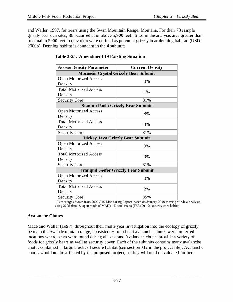
Motorized access was recognized by the FNF Forest Plan in 1986 as a major factor affecting grizzly bear habitat security and was confirmed by research conducted in the nearby Swan Mountains of Montana (Mace and Waller 1997). Wielgus et al. (2002) demonstrated the tendency for grizzly bears to select against open roads in a 1986-1991 study in the Selkirk Mountains of northern Idaho and southern British Columbia. Mace and Waller (1997) recommended that until effective management programs for reducing human-caused grizzly bear mortalities are developed for private lands, federal lands should be considered invaluable source areas. Federal lands were found to be areas where more bears survive than die and should be managed to reduce man-caused mortality. The authors suggested that this could be accomplished by establishing high security areas that include seasonal habitats and where vehicle access is restricted. Research supports the premise that forest roads facilitate human access into grizzly bear habitat, which directly or indirectly increases the risk of mortality to grizzly bear (US Fish and Wildlife Service 2005). Specific management direction related to motorized access is embodied in Amendment 19 (A-19) of the Flathead Forest Plan. A-19 is a comprehensive, programmatic strategy that addresses grizzly bear habitat security through access density objectives at the subunit scale of analysis. The U.S. Fish and Wildlife Service (USFWS), in their Biological Opinion (BO) for A-19 (USDI Fish and Wildlife Service 1995) and their BO for a revised A-19 implementation schedule, (USDI Fish and Wildlife Service 2005) put forth ‘Terms and Conditions’ with which the Forest was required to comply. The biological judgment of the USFWS was that “harm” of grizzly bears is likely to occur in the following conditions: when the open motorized access density (OMAD) exceeds 19% of a subunit, when the total motorized access density (TMAD) exceeds 19% of a subunit; when security core is less than 68% of a subunit, or when amended subunit access standards based on site-specific information with USFS/USFWS concurrence are not met. All of the analysis area subunits are >75% Forest Service ownership and all are in compliance with A-19 standards (see Table 3-25). Effects of proposed activities upon A-19 standards will be evaluated. Denning Habitat Table 3-26 displays the acreage of grizzly bear subunits and key habitat components. Potential grizzly bear denning habitat was mapped using the den site elevation criteria identified by Mace
Middle Fork Fuels Reduction Project Chapter 3 – Grizzly Bear
3-77
and Waller, 1997, for bears using the Swan Mountain Range, Montana. For their 78 sample grizzly bear den sites; 86 occurred at or above 5,900 feet. Sites in the analysis area greater than or equal to 5900 feet in elevation were defined as potential grizzly bear denning habitat. (USDI 2000b). Denning habitat is abundant in the 4 subunits.
Table 3-25. Amendment 19 Existing Situation
Access Density Parameter Current Density Mocassin Crystal Grizzly Bear Subunit
Open Motorized Access Density
8%
Total Motorized Access Density
1%
Security Core 81% Stanton Paola Grizzly Bear Subunit
Open Motorized Access Density
8%
Total Motorized Access Density
3%
Security Core 81% Dickey Java Grizzly Bear Subunit
Open Motorized Access Density
9%
Total Motorized Access Density
0%
Security Core 81% Tranquil Geifer Grizzly Bear Subunit
Open Motorized Access Density
0%
Total Motorized Access Density
2%
Security Core 85% ¹ Percentages drawn from 2009 A19 Monitoring Report, based on January 2009 moving window analysis using 2008 data; % open roads (OMAD) - % total roads (TMAD) - % security core habitat Avalanche Chutes Mace and Waller (1997), throughout their multi-year investigation into the ecology of grizzly bears in the Swan Mountain range, consistently found that avalanche chutes were preferred locations where bears were found during all seasons. Avalanche chutes provide a variety of foods for grizzly bears as well as security cover. Each of the subunits contains many avalanche chutes contained in large blocks of secure habitat (see section M2 in the project file). Avalanche chutes would not be affected by the proposed project, so they will not be evaluated further.
Middle Fork Fuels Reduction Project Chapter 3 – Grizzly Bear
3-78
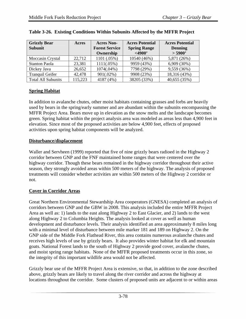
Table 3-26. Existing Conditions Within Subunits Affected by the MFFR Project Grizzly Bear Subunit
Acres Acres Non-Forest Service
Ownership
Acres Potential Spring Range
<4900’
Acres Potential Denning > 5900’
Moccasin Crystal 22,712 1101 (.05%) 10540 (46%) 5,871 (26%) Stanton Paola 23,381 1111(.05%) 9959 (43%) 6,909 (30%) Dickey Java 26,652 1074(.04%) 7798 (29%) 9,559 (36%) Tranquil Geifer 42,478 901(.02%) 9908 (23%) 18,316 (43%) Total All Subunits 115,223 4187 (4%) 38205 (33%) 40,655 (35%) Spring Habitat In addition to avalanche chutes, other moist habitats containing grasses and forbs are heavily used by bears in the spring/early summer and are abundant within the subunits encompassing the MFFR Project Area. Bears move up in elevation as the snow melts and the landscape becomes green. Spring habitat within the project analysis area was modeled as areas less than 4,900 feet in elevation. Since most of the proposed activities are below 4,900 feet, effects of proposed activities upon spring habitat components will be analyzed. Disturbance/displacement Waller and Servheen (1999) reported that five of nine grizzly bears radioed in the Highway 2 corridor between GNP and the FNF maintained home ranges that were centered over the highway corridor. Though these bears remained in the highway corridor throughout their active season, they strongly avoided areas within 500 meters of the highway. The analysis of proposed treatments will consider whether activities are within 500 meters of the Highway 2 corridor or not. Cover in Corridor Areas Great Northern Environmental Stewardship Area cooperators (GNESA) completed an analysis of corridors between GNP and the GBW in 2008. This analysis included the entire MFFR Project Area as well as: 1) lands to the east along Highway 2 to East Glacier, and 2) lands to the west along Highway 2 to Columbia Heights. The analysis looked at cover as well as human development and disturbance levels. Their analysis identified an area approximately 8 miles long with a minimal level of disturbance between mile marker 181 and 189 on Highway 2. On the GNP side of the Middle Fork Flathead River, this area contains numerous avalanche chutes and receives high levels of use by grizzly bears. It also provides winter habitat for elk and mountain goats. National Forest lands to the south of Highway 2 provide good cover, avalanche chutes, and moist spring range habitats. None of the MFFR proposed treatments occur in this zone, so the integrity of this important wildlife area would not be affected. Grizzly bear use of the MFFR Project Area is extensive, so that, in addition to the zone described above, grizzly bears are likely to travel along the river corridor and across the highway at locations throughout the corridor. Some clusters of proposed units are adjacent to or within areas
Middle Fork Fuels Reduction Project Chapter 3 – Grizzly Bear
3-79
that currently accommodate relatively secure travel across the corridor. These areas include: 1) Great Bear to Crystal Creek, 2) Pinnacle to Paola Creek, and 3) Dickey Creek. Because of the importance of the corridor between GNP and the GBW, site specific effects of proposed activities upon cover are discussed below for these three areas.
Human Uses There are several developed sites within the project area such as Zip’s Cabin and Devil Creek Campground. Zip’s is on the cabin rental program and is available from June through March. Devil Creek has 14 campsites, water for campers, power and phone for the hosts. It is available from early June through October 31. The Middle Fork of the Flathead River is designated as a Wild and Scenic River given the existing outstanding remarkable values (ORV). The ORVs include water quality, wildlife habitat for Threatened and Endangered species (TES), native fisheries, geology, and scenery. The existing management of the corridor provides for mitigations to protect these ORVs. These mitigations include seasonal road closures, camping restrictions, limits on motorized use for the Middle Fork segment and the protecting the visual integrity of the surrounding area. The ownership pattern within the project area is primarily Forest Service with interspersion of private and some state lands (see Table 3-26); with most non-Forest Service land ownership being private. There are a number of authorized occupancies of National Forest System lands in the area. There are approximately 27 permits issued for an assortment of private water systems/lines, roads, and utility lines throughout the project area. There are two authorizations for groomed cross country ski trail systems at Glacier Wilderness Resort and Izaak Walton Inn. The Essex summer home tract falls within the project area as well. The tract includes private cabins authorized on National Forest System lands through a recreation residence permit. They are accessed by the Essex Rd #1640 or hiking across the Burlington Northern (BN) railroad at the Izaak Walton Inn. One of the grizzly bear management priorities specified for lands designated as MS 1 (see Table 3-29 in regulatory consistency section) is to reduce grizzly-human conflicts. Grizzly-human conflicts are known to increase during poor berry years, or when human-related attractants such as improperly stored food, garbage, pet or livestock food, bird feeders, and fruit trees attract bears into areas where people live or camp. The NCDE Food Storage Order is in effect for all permitted uses of national forest lands. The MDFWP Grizzly Bear Management Specialist works with local residents to prevent and deal with human grizzly conflicts in the area as needed. Alternative 2 would not affect human recreation uses; they will not improve roads into recreation sites nor cause direct or indirect increases in human uses associated with recreation or private land use, so effects will not be evaluated.
Middle Fork Fuels Reduction Project Chapter 3 – Grizzly Bear
3-80
Environmental Consequences Introduction The effects indicators used for assessing potential effects include the following: 1) habitat security as related to A-19, 2) displacement/disturbance in areas outside of the 500 meter Highway 2 corridor, 3) cover in corridors between Glacier National Park and the Great Bear Wilderness, and 4) spring range food availability. Alternative 1 (No Action) Direct, Indirect, and Cumulative Effects In terms of A-19, all five subunits would continue to provide a high level of habitat security that is well below the level that would cause “harm” to the grizzly bear (US Fish and Wildlife Service 2005; Table 3-25). Abundant food such as serviceberry, buffaloberry, huckleberry, and spring season grasses and forbs would continue to be available. Forest cover would be maintained in corridor areas unless it is destroyed by fire, insect/disease epidemics, or blow down. However, additional insect infestations would be likely to continue to kill trees and increase fuels; therefore stand replacing wildfires would be likely to occur in the future. Grizzly bears would continue to be displaced by human activities, particularly within the Highway 2 corridor, and come into conflict with humans in areas where attractants are present. Bear managers would continue to make efforts to reduce conflicts between grizzly bears and humans through education, relocation, and aversive conditioning of problem bears (in accordance with IGBC/Forest Plan Direction). Alternative 2 (Proposed Action) Direct and Indirect Effects A-19 Motorized Use of Roads and Security Core Habitat Details on temporary roads can be found in sections of chapter 2 and in design criteria. All 5 grizzly bear subunits currently have over 80% security core and have open or total road densities less than 10%. All 5 subunits would meet A-19 standards before, during, and following proposed activities. A19 values displayed in Table 3-25 would not change. Most areas proposed for treatment in the MFFR Project Area are along existing open roads or roads that are open seasonally. The proposed project would result in construction of approximately 4 miles of temporary roads which would be located within treatment unit boundaries. None of the proposed temporary roads or treatments units are within core habitat, therefore, potential grizzly bear use of core habitat will not be affected by temporary roads.
Middle Fork Fuels Reduction Project Chapter 3 – Grizzly Bear
3-81
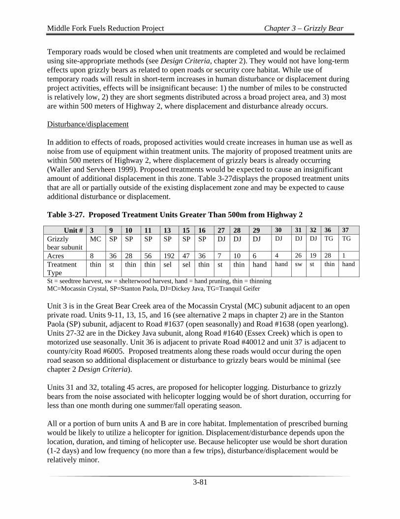
Temporary roads would be closed when unit treatments are completed and would be reclaimed using site-appropriate methods (see Design Criteria, chapter 2). They would not have long-term effects upon grizzly bears as related to open roads or security core habitat. While use of temporary roads will result in short-term increases in human disturbance or displacement during project activities, effects will be insignificant because: 1) the number of miles to be constructed is relatively low, 2) they are short segments distributed across a broad project area, and 3) most are within 500 meters of Highway 2, where displacement and disturbance already occurs. Disturbance/displacement In addition to effects of roads, proposed activities would create increases in human use as well as noise from use of equipment within treatment units. The majority of proposed treatment units are within 500 meters of Highway 2, where displacement of grizzly bears is already occurring (Waller and Servheen 1999). Proposed treatments would be expected to cause an insignificant amount of additional displacement in this zone. Table 3-27displays the proposed treatment units that are all or partially outside of the existing displacement zone and may be expected to cause additional disturbance or displacement. Table 3-27. Proposed Treatment Units Greater Than 500m from Highway 2
Unit # 3 9 10 11 13 15 16 27 28 29 30 31 32 36 37
Grizzly bear subunit
MC SP SP SP SP SP SP DJ DJ DJ DJ DJ DJ TG TG
Acres 8 36 28 56 192 47 36 7 10 6 4 26 19 28 1
Treatment Type
thin st thin thin sel sel thin st thin hand hand sw st thin hand
St = seedtree harvest, sw = shelterwood harvest, hand = hand pruning, thin = thinning MC=Mocassin Crystal, SP=Stanton Paola, DJ=Dickey Java, TG=Tranquil Geifer Unit 3 is in the Great Bear Creek area of the Mocassin Crystal (MC) subunit adjacent to an open private road. Units 9-11, 13, 15, and 16 (see alternative 2 maps in chapter 2) are in the Stanton Paola (SP) subunit, adjacent to Road #1637 (open seasonally) and Road #1638 (open yearlong). Units 27-32 are in the Dickey Java subunit, along Road #1640 (Essex Creek) which is open to motorized use seasonally. Unit 36 is adjacent to private Road #40012 and unit 37 is adjacent to county/city Road #6005. Proposed treatments along these roads would occur during the open road season so additional displacement or disturbance to grizzly bears would be minimal (see chapter 2 Design Criteria). Units 31 and 32, totaling 45 acres, are proposed for helicopter logging. Disturbance to grizzly bears from the noise associated with helicopter logging would be of short duration, occurring for less than one month during one summer/fall operating season. All or a portion of burn units A and B are in core habitat. Implementation of prescribed burning would be likely to utilize a helicopter for ignition. Displacement/disturbance depends upon the location, duration, and timing of helicopter use. Because helicopter use would be short duration (1-2 days) and low frequency (no more than a few trips), disturbance/displacement would be relatively minor.
Middle Fork Fuels Reduction Project Chapter 3 – Grizzly Bear
3-82
Cover in Corridor Areas A minimum of 40% cover would be maintained in all subunits. In general, seedtree, shelterwood and commercial thinning activities reduce cover in an area to a greater degree for grizzly bears than hand thinning, sapling thinning, and group selection activities and so will be used as a focus of the effects of proposed activities. In most locations, the effects of group selection harvest, hand thinning, and sapling thinning are relatively insignificant in terms of their effects on cover. Great Bear to Crystal Creek Area Units 3-6 occur in this area. Units 3, 4, and 6 are adjacent to the Wilderness Lodge and removal of cover in these small units would not affect grizzly use of the corridor to a significant extent. Unit 5 encompasses 112 acres and is proposed for 60 acres of group selection harvest within the total unit boundary. Tree removal in unit 5 would have a negative impact upon grizzly bear habitat by removing cover in an important corridor. Due to the high number of wet sites interspersed throughout this unit, the remaining large spruce and cottonwoods around the edges of openings would be more likely to blow down after harvest, resulting in even greater loss of cover. It would be beneficial for bears to leave most of unit 5 untreated and harvest more trees in portions of the unit immediately adjacent to private land and the power line corridor.
Pinnacle to Paola Creek Area Units 9-18 occur in this area, including three units for seedtree and commercial thin activities (units 9, 14, and 18) totaling 132 acres. Logging of units 9, 14, and 18 would reduce cover, but because they would be surrounded by blocks of good cover, bears would still be able to move between GNP and the GBW. Proposed noncommercial thinning of unit 13, totaling 112 acres, contains numerous moist sites and meadows which are of high value to bears and other wildlife. As a result, removal of cover due to thinning would have greater impacts than usual. During unit layout, areas adjacent to meadows and along the road would be designated for “no thinning” treatment (Design Criteria, chapter 2). Unit 15 encompasses 47 acres and is proposed for 23 acres of group selection harvest within the total unit boundary. This unit contains numerous wet sites which are of high value to bears and other wildlife. Group selection harvest is expected to maintain adequate cover around these wet sites. Dickey Creek Area Units 24-26 occur in this area, including three shelterwood and commercial thin harvest units totaling 187 acres. These units occur between private land at Essex and private residences at Dickey Creek that currently provides cover for travel for bears and other wildlife. Logging of these 3 units would reduce cover for bears moving between GNP and the GBW; leaving an
Middle Fork Fuels Reduction Project Chapter 3 – Grizzly Bear
3-83
unthinned strip bisecting the unit 24 from top to bottom would help mitigate for this and would maintain more cover for travel (Design Criteria, chapter 2). Spring Habitat The MFFR project area contains numerous wet areas that produce spring bear foods. Avalanche chutes are abundant in surrounding areas of GNP and the GBW. Most proposed activities would not occur from April 1- June 30 to avoid this key grizzly use season. Proposed precommercial thinning, group selection harvest, and hand fuels reduction treatments would create small openings that would produce bear foods, while maintaining cover. Seed tree, shelterwood, and commercial thin units would produce bear foods, but would also result in reductions in cover that would make portions of these units less likely to be used for forage. Bear use of foods in many harvest and thinning units would also be reduced by their location in the zone that is within 500 meters of Highway 2, where displacement/disturbance levels are high. Prescribed burn units A and D, as well as portions of B, C and E are modeled as spring grizzly habitat. Prescribed burning of unit A and the lower 2/3 of C would not improve spring forage for bears. Burning of B, D, and E would be expected to promote growth of spring bear foods. These units would be burned with a helicopter in the fall to avoid disturbance or displacement of grizzly bears during the key spring bear use season. Denning Habitat The upper portion of burn unit C is in an area above 5900 feet elevation and provides potential denning habitat. Mace and Waller (1997) found that most dens were located in habitats classified as open (40%) and open-timbered (42%), with a conifer overstory of <60%. Burning would be likely to kill pockets of grasses, shrubs, and trees, creating open-timbered habitat that would be suitable for denning following burning. Cumulative Effects Potential impacts to bears resulting from alternative 2 are primarily related to temporary, (rather than permanent) changes in road access, disturbance/displacement, reductions in cover, and increases in native vegetation species that provide food sources (in some cases near urban structures). The potential for these impacts to cumulatively impact bears with consideration to other past, future, or on-going activities or influences, depends upon whether or not these impacts will interact in time and space with one another, as discussed below. Many of the potential impacts of this project would occur within the areas of influence of other on-going impacts to bears; the proposed project would not cumulatively create adverse impacts to grizzly bears, as discussed below. Human Use Grizzly bears would continue to be displaced by human activities, particularly within the Highway 2 corridor, and come into conflict with humans in areas where attractants are present. Bear managers would continue to make efforts to reduce conflicts between grizzly bears and
Middle Fork Fuels Reduction Project Chapter 3 – Grizzly Bear
3-84
humans through education, relocation, and aversive conditioning of problem bears, while staying in accordance with IGBC/Forest Plan Direction. Some private timberlands in the area have been sold for residential development and additional sales of this type are expected in the future. Homes and businesses have been constructed throughout the project area. Development of private lands has led to risks to bears due to the presence of attractants, which has led to removal of bears. The influence of these developments has been present for decades, with the number of developments continuing to increase. This has led to increased disturbance/displacement for bears and to increased potential for food rewards and conflict. The impacts of development would continue to occur along-side the potential impacts of this project; specifically displacement/disturbance due to project implementation discussed in the direct/indirect effects sections above. Spills of grain and other bear attractants along the railroad corridor has led to a number of grizzly bear mortalities. Burlington Northern (BN) Railroad and GNESA are working with grizzly managers to reduce this source of mortality. Recreation Proposed activities would not be expected to lead to increases or decreases in recreational activities currently influencing the environmental baseline for bears, so there would not be cumulative effects. Habitat effectiveness for grizzly bears has been improving in the analysis area as a result of the NCDE Food Storage Order. Beginning in 1998 and revised in 2000, this special order requires people to store bear attractants in a bear resistant manner while on National Forest land. There are two proposed fuel reduction units that are directly adjacent to Devil Creek Campground/Trailhead (unit 33) and Zip’s Cabin (unit 37). Unit 33 includes using mechanical equipment to thin the lodgepole pine and remove high risk trees. Unit 37 would have hand removal of fuels and understory pruning. Grizzly bear use of these developed sites is not desirable because it increases the potential for human-bear conflicts. Proposed treatments would not enhance grizzly bear habitat at these sites. Timber Harvest, Fire, Insects and Disease Proposed activities are designed to create a defensible space around developments by reducing fuels, to help protect them from destruction by wildfire. Pockets of insect and disease would continue to increase fuels in and adjacent to the project area in the foreseeable future. Portions of each subunit are in the Great Bear Wilderness, where wildfires would continue to occur, and allow natural processes to affect bear habitat. On FNF lands, the Challenge Fire of 1998, and the Skyland Fire of 2007, created openings of varying sizes and overstory mortality conducive to understory regeneration. This has increased food production and resulted in removal of cover for bears, some of which was cover adjacent to open roads. Wildfires that have occurred in the last 15 years across the Middle Fork Flathead River in Glacier National Park, including the Belton, Center, Harrison, Triangle and Rampage
Middle Fork Fuels Reduction Project Chapter 3 – Grizzly Bear
3-85
Fires, had similar effects. Within the next 10-15 years these fire areas are expected to go through natural succession, moving from a condition of providing forage to one of providing hiding cover. Past timber harvest on public and private land has also increased food production while reducing cover in many cases. Roads/Motorized Access Past road building associated with previous harvest has also negatively impacted bears over time because bears are more likely to avoid habitats and food sources adjacent to roads. Alternative 2 would not create cumulative effects in terms of the ongoing implementation of motorized access restrictions required by Amendments 19 and 24. A large majority of the CEA is unroaded and/or not open to public motorized travel. Access to the area is primarily facilitated by Highway 2, private roads, and a relatively limited number of FS roads in comparison to other non-wilderness portions of the Flathead National Forest. Connectivity The locations of proposed activities are such that there would be broad expanses of forested land with good cover available to bears during and following proposed activities. Proposed activities would be timed to avoid increases in human disturbance during the key spring season, to allow grizzly bears to move through the corridor connecting Glacier National Park and the Great Bear Wilderness. No proposed activities are located within the 8 mile section of Highway 2, between mile marker 181 and 189, identified by GNESA as offering key connectivity, as discussed earlier. Where bears may avoid some treatment units for a time period of up to 15 years due to lack of cover, they would primarily do so in areas near human development, where grizzly bear presence is not desirable in terms of minimizing conflict. Considering both the cumulative and on-going effects this project would have on connectivity, the project would have little additional affect on the ability of grizzly bears to travel from GNP to the GBW. NCDE and Forest Scale Assessment Flathead National Forest lands comprise approximately 40% of the Northern Continental Divide Grizzly Bear Ecosystem (NCDE). Flathead National Forest land ownership occurs within 73 grizzly bear subunits totaling 2,452,410 acres, and the Flathead Forest Plan Amendment 19 (A19-USDA Forest Service1995a and 1995b) applies to 54 subunits totaling 1,662,162 acres. Of the 19 subunits where A-19 does not apply, 16 are within the Bob Marshall Wilderness where road management is not an issue. Habitat effectiveness is high in all the wilderness subunits with only a few high use trails affecting grizzly bears. The other 3 subunits are in the Stillwater River drainage where National Forest System lands comprise less than 10% of the subunits. Amendment 19 applies to 54 subunits (primarily outside the wilderness) and was developed to provide Forest Plan direction concerning levels of open roads, total roads, and secure or “core” habitat that would contribute to the recovery and conservation of grizzly bears. The standards are described in the Decision Notice for A-19 (USDA Forest Service 1995b).
Middle Fork Fuels Reduction Project Chapter 3 – Grizzly Bear
3-86
Forty of the 54 subunits, including those in the proposed project area, have National Forest System ownership >75%. Twenty-nine of them met the standard of 19% open motorized access density, twenty-eight met the standard of 19% total motorized access density, and 68% met the standard of 68% security core at the end of 2008 (US Forest Service 2008). Progress in closing and decommissioning roads has been substantial across the Flathead National Forest’s portion of the Northern Continental Divide Ecosystem when considering the miles of roads that have been restricted or decommissioned since A-19 was signed in 1995. Available information indicates that on the Glacier View Ranger District, Hungry Horse Ranger District, and the Swan Lake Ranger District1between 1995 and 1999, total miles decreased by about 210 miles, open miles decreased about 145 miles, seasonally open miles decreased about 5 miles, and restricted miles decreased about 60 miles between 1995 and 1999. Additional miles of roads have been restricted and decommissioned since 1999 but updated numbers are not available at this time. Food Storage Order: Minimizing the risk of mortality due to conflict with humans and human associated foods is also an important facet of grizzly bear management. A food storage special order was signed on April 15, 1998 (revised in 2000) that applies to National Forest System lands within the Northern Continental Divide Ecosystem on the Flathead, Lewis and Clark, Lolo, and Helena National Forests. The purpose of the restrictions is to minimize grizzly bear/human conflicts and thereby provide for visitor safety and recovery of the grizzly bear. The food storage order contains requirements for storage and handling of bear attractants such as human foods and garbage, livestock feed, and wildlife and livestock carcasses. Cooperative Access Management: A19 includes an objective to “improve habitat effectiveness through cooperative management with other land ownerships, land adjustments, or other means.” The FNF in cooperation with Plum Creek Timber Company, Montana Department of Natural Resources and Conservation, and the U. S. Fish and Wildlife Service, developed and implemented an agreement for access management and timber harvest scheduling in the intermingled ownership lands of the Swan Valley. The Swan Valley Grizzly Bear Conservation Agreement (US Fish and Wildlife Service et al 1997) established a cooperative management plan to promote grizzly bear habitat use and security on approximately 370,000 acres. Cooperation with Montana Fish, Wildlife, and Parks: The Flathead National Forest has cooperated with, and helped fund, a Grizzly Bear Management Specialist position with Montana Fish, Wildlife, and Parks since inception of the position in northwest Montana. The position works on both public and private lands to correct problem situations and educate people about how to live with bears and minimize the potential for conflicts. The management specialist has pioneered efforts in rapid and complete cleanup of railroad grain spills, the use of aversive conditioning techniques to educate bears including the use of Karelian bear dogs, and the hazard and necessity of the cleanup of large and small attractants at private residences. The work may lead to an increased ability of grizzly bears to utilize habitats in areas currently having high mortality risk and low use potential.
Regulatory Framework and Consistency
Middle Fork Fuels Reduction Project Chapter 3 – Grizzly Bear
3-87
On March 8, 2000, the Flathead National Forest requested re-initiation of formal consultation with the US Fish and Wildlife Service (FWS) to consider a revised A-19 implementation schedule on the forest. This consultation process produced a Biological Opinion (BO) on October 25, 2005. The USFWS concluded in the BO that the proposed extension of implementation timelines for A-19 is not likely to appreciably diminish survival and recovery of grizzly bears. This BO put forth ‘Terms and Conditions’ with which the FNF was required to comply. The goal of the requirements was to gradually achieve motorized access objectives across the FNF in grizzly bear habitat. The terms and conditions established five and ten-year numerical motorized access density objectives. The FNF found itself unable to meet the timelines set by the USFWS BO and, therefore, re-initiated formal consultation in December 2004. A new BO was issued in October 2005 on a revised implementation schedule for A19 that provided new Terms and Conditions. All five subunits analyzed for the Middle Fork Fuels Reduction project would fully meet A19 grizzly bear habitat standards before, during and after proposed project activities (Table 3-25). The proposed project is in compliance with the BO. The grizzly bear is listed as "threatened" in Montana, and the Grizzly Bear Recovery Plan (1993) provides recovery goals and objectives for the grizzly bear. The Flathead Forest Plan (pages II-38 to II-42) provides management direction and standards and guidelines to guide project planning. The Interagency Grizzly Bear Guidelines (1986) provide additional guidance for grizzly bear habitat management. The project area lies within grizzly bear Management Situation 1 (MS1), as designated by the Forest Plan.
Middle Fork Fuels Reduction Project Chapter 3 – Grizzly Bear
3-88
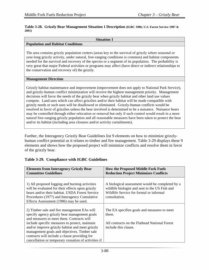
Table 3-28. Grizzly Bear Management Situation 1 Description (IGBC 1986; U.S. Forest Service 1987 & 2001)
Situation 1
Population and Habitat Conditions The area contains grizzly population centers (areas key to the survival of grizzly where seasonal or year-long grizzly activity, under natural, free-ranging conditions is common) and habitat components needed for the survival and recovery of the species or a segment of its population. The probability is very great that major Federal activities or programs may affect (have direct or indirect relationships to the conservation and recovery of) the grizzly. Management Direction Grizzly habitat maintenance and improvement (improvement does not apply to National Park Service), and grizzly-human conflict minimization will receive the highest management priority. Management decisions will favor the needs of the grizzly bear when grizzly habitat and other land use values compete. Land uses which can affect grizzlies and/or their habitat will be made compatible with grizzly needs or such uses will be disallowed or eliminated. Grizzly-human conflicts would be resolved in favor of grizzlies unless the bear involved is determined to be a nuisance. Nuisance bears may be controlled through either relocation or removal but only if such control would result in a more natural free-ranging grizzly population and all reasonable measures have been taken to protect the bear and/or its habitat (including area closures and/or activity curtailments).
Further, the Interagency Grizzly Bear Guidelines list 9 elements on how to minimize grizzly-human conflict potential as it relates to timber and fire management. Table 3-29 displays these 9 elements and shows how the proposed project will minimize conflicts and resolve them in favor of the grizzly bear. Table 3-29. Compliance with IGBC Guidelines Elements from Interagency Grizzly Bear Committee Guidelines
How the Proposed Middle Fork Fuels Reduction Project Minimizes Conflicts
1) All proposed logging and burning activities will be evaluated for their effects upon grizzly bears and/or their habitat. USDA Forest Service Procedures (1977) and Interagency Cumulative Effects Assessment (1986) may be used.
A biological assessment would be completed by a wildlife biologist and sent to the US Fish and Wildlife Service for formal or informal consultation.
2) Timber sale and fire management EAs will specify agency grizzly bear management goals and measures to meet them. Contracts will include specific measures to protect, maintain and/or improve grizzly habitat and meet grizzly management goals and objectives. Timber sale contracts will include a clause providing for cancellation or temporary cessation of activities if
The EA specifies goals and measures to meet them. All contracts on the Flathead National Forest include this clause.
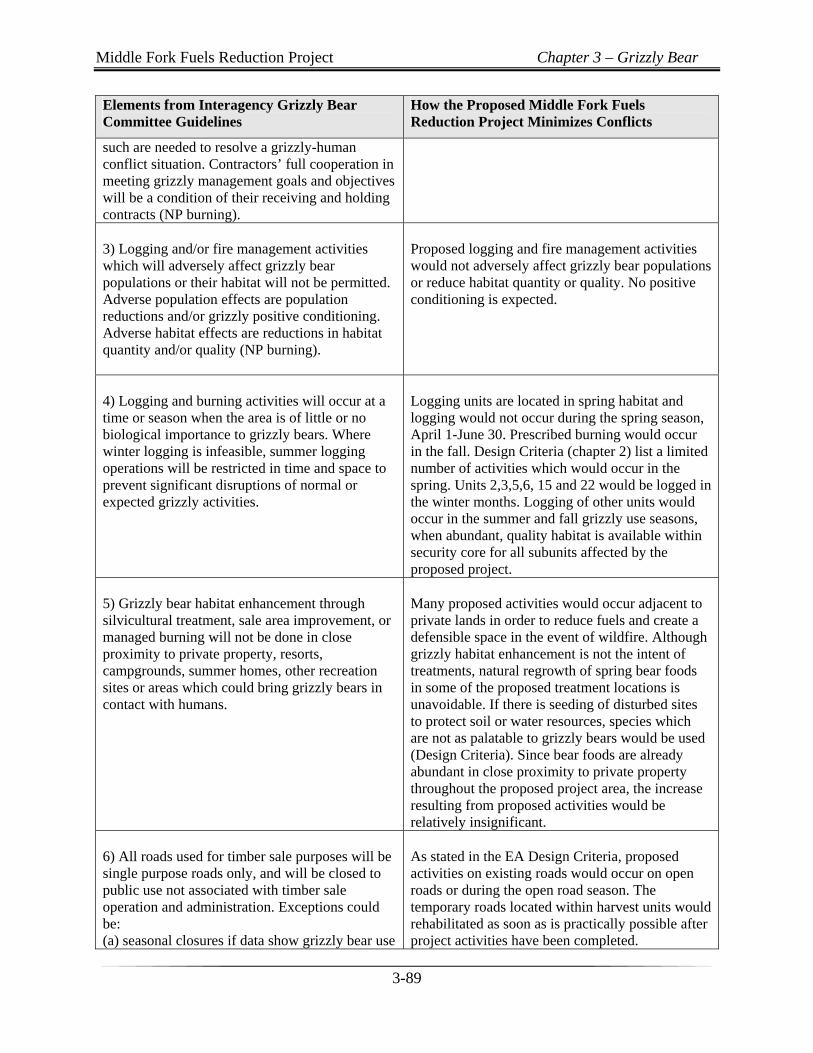
Middle Fork Fuels Reduction Project Chapter 3 – Grizzly Bear
3-89
Elements from Interagency Grizzly Bear Committee Guidelines
How the Proposed Middle Fork Fuels Reduction Project Minimizes Conflicts
such are needed to resolve a grizzly-human conflict situation. Contractors’ full cooperation in meeting grizzly management goals and objectives will be a condition of their receiving and holding contracts (NP burning). 3) Logging and/or fire management activities which will adversely affect grizzly bear populations or their habitat will not be permitted. Adverse population effects are population reductions and/or grizzly positive conditioning. Adverse habitat effects are reductions in habitat quantity and/or quality (NP burning).
Proposed logging and fire management activities would not adversely affect grizzly bear populations or reduce habitat quantity or quality. No positive conditioning is expected.
4) Logging and burning activities will occur at a time or season when the area is of little or no biological importance to grizzly bears. Where winter logging is infeasible, summer logging operations will be restricted in time and space to prevent significant disruptions of normal or expected grizzly activities.
Logging units are located in spring habitat and logging would not occur during the spring season, April 1-June 30. Prescribed burning would occur in the fall. Design Criteria (chapter 2) list a limited number of activities which would occur in the spring. Units 2,3,5,6, 15 and 22 would be logged in the winter months. Logging of other units would occur in the summer and fall grizzly use seasons, when abundant, quality habitat is available within security core for all subunits affected by the proposed project.
5) Grizzly bear habitat enhancement through silvicultural treatment, sale area improvement, or managed burning will not be done in close proximity to private property, resorts, campgrounds, summer homes, other recreation sites or areas which could bring grizzly bears in contact with humans.
Many proposed activities would occur adjacent to private lands in order to reduce fuels and create a defensible space in the event of wildfire. Although grizzly habitat enhancement is not the intent of treatments, natural regrowth of spring bear foods in some of the proposed treatment locations is unavoidable. If there is seeding of disturbed sites to protect soil or water resources, species which are not as palatable to grizzly bears would be used (Design Criteria). Since bear foods are already abundant in close proximity to private property throughout the proposed project area, the increase resulting from proposed activities would be relatively insignificant.
6) All roads used for timber sale purposes will be single purpose roads only, and will be closed to public use not associated with timber sale operation and administration. Exceptions could be: (a) seasonal closures if data show grizzly bear use
As stated in the EA Design Criteria, proposed activities on existing roads would occur on open roads or during the open road season. The temporary roads located within harvest units would rehabilitated as soon as is practically possible after project activities have been completed.
Middle Fork Fuels Reduction Project Chapter 3 – Grizzly Bear
3-90
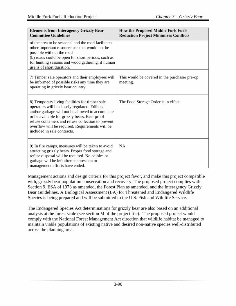
Elements from Interagency Grizzly Bear Committee Guidelines
How the Proposed Middle Fork Fuels Reduction Project Minimizes Conflicts
of the area to be seasonal and the road facilitates other important resource use that would not be possible without the road (b) roads could be open for short periods, such as for hunting seasons and wood gathering, if human use is of short duration. 7) Timber sale operators and their employees will be informed of possible risks any time they are operating in grizzly bear country.
This would be covered in the purchaser pre-op meeting.
8) Temporary living facilities for timber sale operators will be closely regulated. Edibles and/or garbage will not be allowed to accumulate or be available for grizzly bears. Bear proof refuse containers and refuse collection to prevent overflow will be required. Requirements will be included in sale contracts.
The Food Storage Order is in effect.
9) In fire camps, measures will be taken to avoid attracting grizzly bears. Proper food storage and refuse disposal will be required. No edibles or garbage will be left after suppression or management efforts have ended.
NA
Management actions and design criteria for this project favor, and make this project compatible with, grizzly bear population conservation and recovery. The proposed project complies with Section 9, ESA of 1973 as amended, the Forest Plan as amended, and the Interagency Grizzly Bear Guidelines. A Biological Assessment (BA) for Threatened and Endangered Wildlife Species is being prepared and will be submitted to the U.S. Fish and Wildlife Service. The Endangered Species Act determinations for grizzly bear are also based on an additional analysis at the forest scale (see section M of the project file). The proposed project would comply with the National Forest Management Act direction that wildlife habitat be managed to maintain viable populations of existing native and desired non-native species well-distributed across the planning area.