vertical navigation (for pbn)
TRANSCRIPT
The European Organisation for the Safety of Air Navigation
Vertical Navigation (for PBN) David De SmedtEUROCONTROL
September 2012
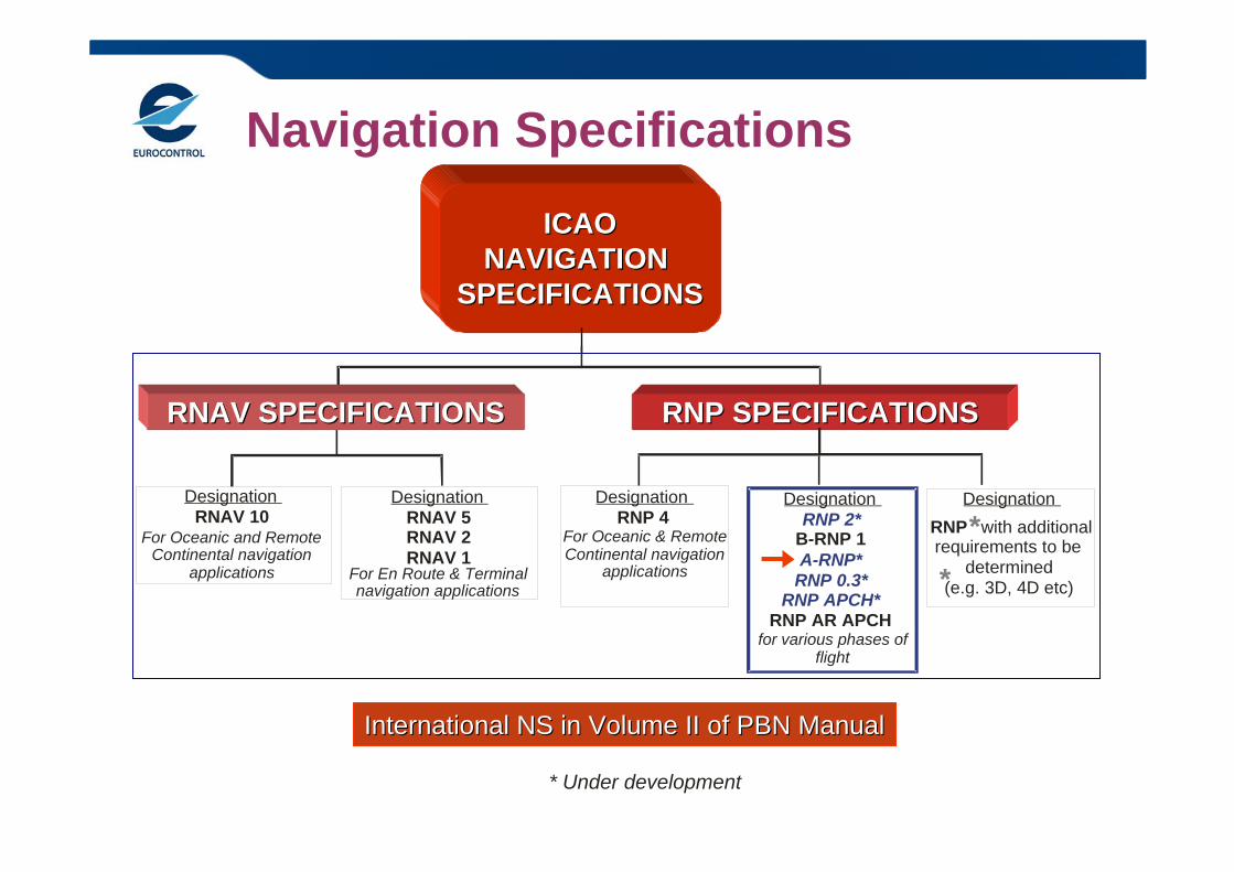
Navigation Specifications
ICAOICAONAVIGATION NAVIGATION
SPECIFICATIONSSPECIFICATIONS
International NS in Volume II of PBN ManualInternational NS in Volume II of PBN Manual
Designation RNAV 5RNAV 2RNAV 1
Designation RNAV 10
For Oceanic and Remote Continental navigation
applications For En Route & Terminal navigation applications
* Under development
RNP SPECIFICATIONSRNP SPECIFICATIONSRNAV SPECIFICATIONSRNAV SPECIFICATIONS
DesignationRNP with additional requirements to be
determined (e.g. 3D, 4D etc)
Designation
B-RNP 1
RNP AR APCHfor various phases of
flight
RNP 2*
A-RNP*RNP 0.3*
RNP APCH*
Designation RNP 4
For Oceanic & Remote Continental navigation
applications
*
*
ICAO Recommendations
ICAO (36th Assembly Oct 2007): – States and planning and implementation regional groups
(PIRGs) should complete a PBN implementation plan by 2009 to achieve:
– Implementation of RNAV and RNP operations for en route and terminal areas according to established timelines and intermediate milestones; and
– Implementation of approach procedures with vertical guidance (APV) (Baro-VNAV and/or augmented GNSS) for all instrument runway ends, either as the primary approach or as a back-up for precision approaches by 2016 with intermediate milestones as follows:
• 30% by 2010• 70% by 2014.
ICAO Recommendations
37th ICAO Assembly (Oct 10):Concerning Approach with Vertical guidance (APV), the resolution added:– implementation of straight-in LNAV only procedures, as
an exception, for instrument runways at aerodromes where there is no local altimeter setting available and where there are no aircraft suitably equipped for APV operations.
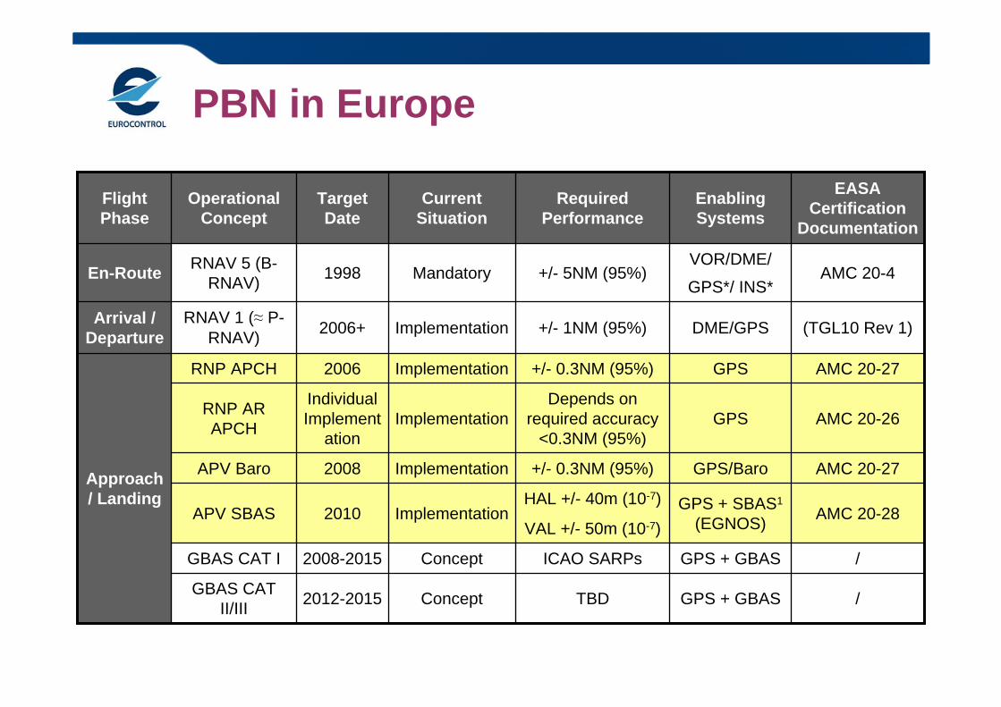
PBN in Europe
VAL +/- 50m (10-7)
/GPS + GBASTBDConcept2012-2015GBAS CAT II/III
/GPS + GBASICAO SARPsConcept2008-2015GBAS CAT I
AMC 20-28GPS + SBAS1
(EGNOS)HAL +/- 40m (10-7)
Implementation2010APV SBAS
AMC 20-27GPS/Baro+/- 0.3NM (95%) Implementation2008APV Baro
AMC 20-26GPSDepends on
required accuracy <0.3NM (95%)
ImplementationIndividual Implement
ation
RNP AR APCH
AMC 20-27GPS+/- 0.3NM (95%) Implementation2006RNP APCH
Approach / Landing
(TGL10 Rev 1)DME/GPS+/- 1NM (95%) Implementation2006+RNAV 1 (≈ P-RNAV)
Arrival / Departure
AMC 20-4VOR/DME/
GPS*/ INS*+/- 5NM (95%) Mandatory 1998RNAV 5 (B-
RNAV)En-Route
EASA Certification
Documentation
Enabling Systems
Required Performance
Current Situation
Target Date
Operational Concept
Flight Phase
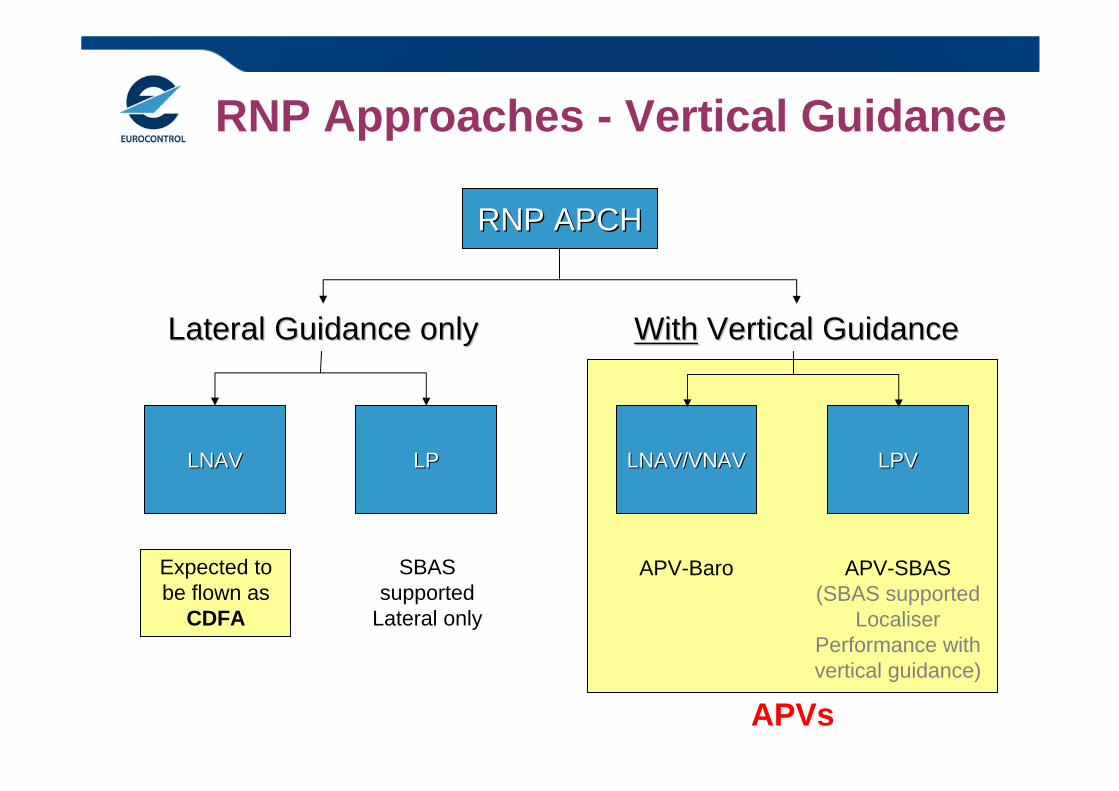
APVs
RNP Approaches - Vertical Guidance
RNP APCHRNP APCH
Lateral Guidance onlyLateral Guidance only WithWith Vertical GuidanceVertical Guidance
LNAVLNAV LPLPLP
Expected to be flown as
CDFA
SBAS supported
Lateral only
LNAV/VNAVLNAV/VNAV LPVLPV
APV-Baro APV-SBAS(SBAS supported
Localiser Performance with vertical guidance)
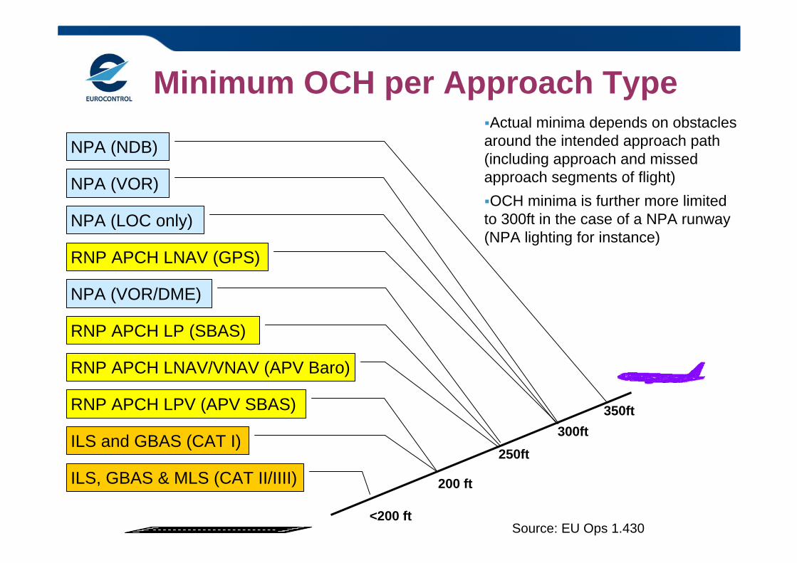
200 ft
RNP APCH LNAV/VNAV (APV Baro)
NPA (VOR/DME)
250ft
RNP APCH LNAV (GPS)
NPA (VOR)
ILS and GBAS (CAT I)
NPA (NDB)
300ft350ft
ILS, GBAS & MLS (CAT II/IIII)
Actual minima depends on obstacles around the intended approach path (including approach and missed approach segments of flight)OCH minima is further more limited to 300ft in the case of a NPA runway (NPA lighting for instance)
RNP APCH LP (SBAS)
<200 ft
NPA (LOC only)
RNP APCH LPV (APV SBAS)
Source: EU Ops 1.430
Minimum OCH per Approach Type
8
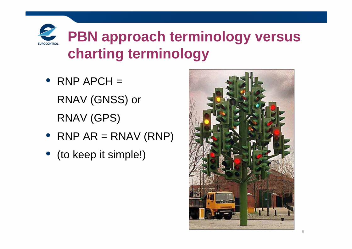
PBN approach terminology versus charting terminology
• RNP APCH =
RNAV (GNSS) or
RNAV (GPS)
• RNP AR = RNAV (RNP)
• (to keep it simple!)
9
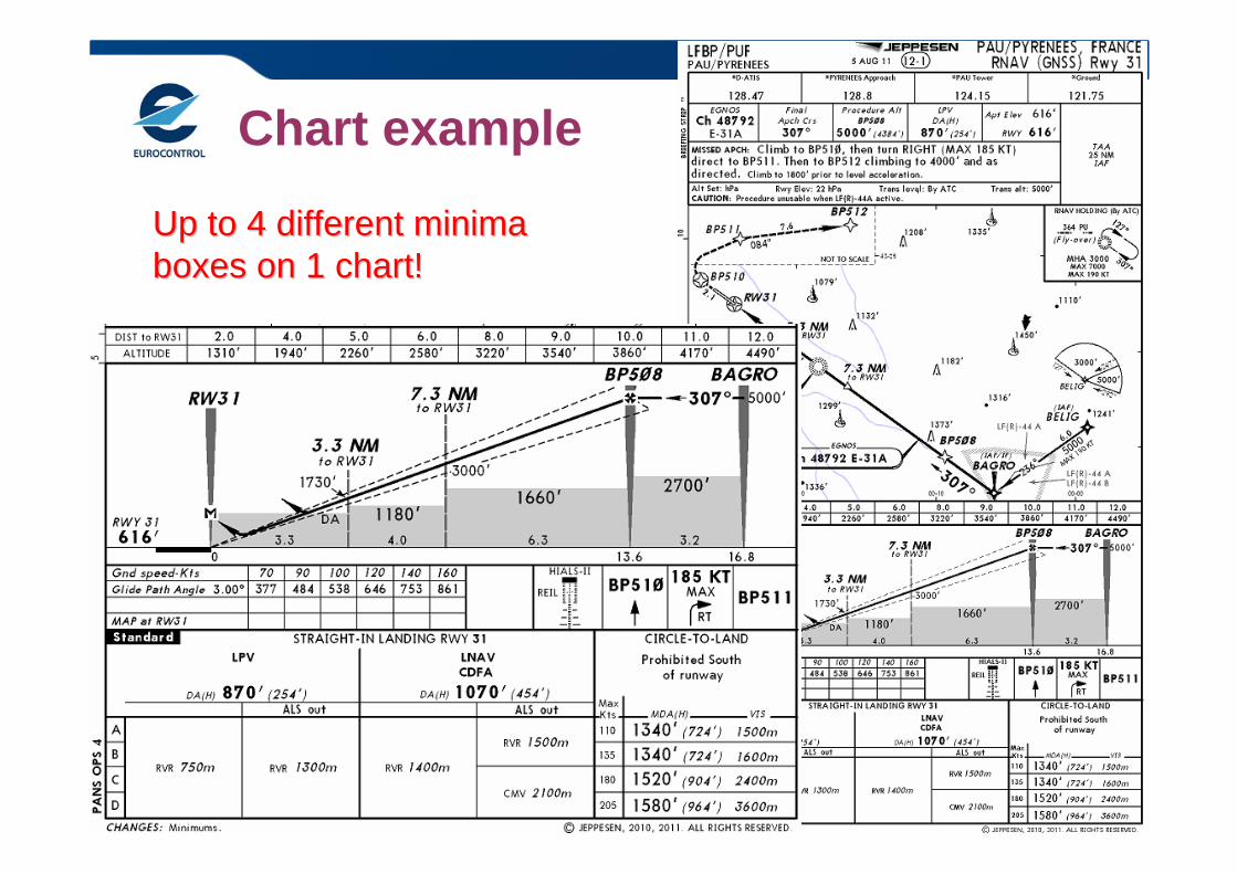
Chart example
Up to 4 different minima Up to 4 different minima boxes on 1 chart!boxes on 1 chart!
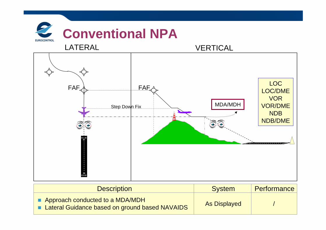
Conventional NPA
36
18
LATERAL VERTICAL
LOCLOC/DME
VORVOR/DME
NDBNDB/DME
Description System Performance Approach conducted to a MDA/MDH Lateral Guidance based on ground based NAVAIDS As Displayed /
MDA/MDH
FAFFAF
Step Down Fix
11
0.3NM (95%)
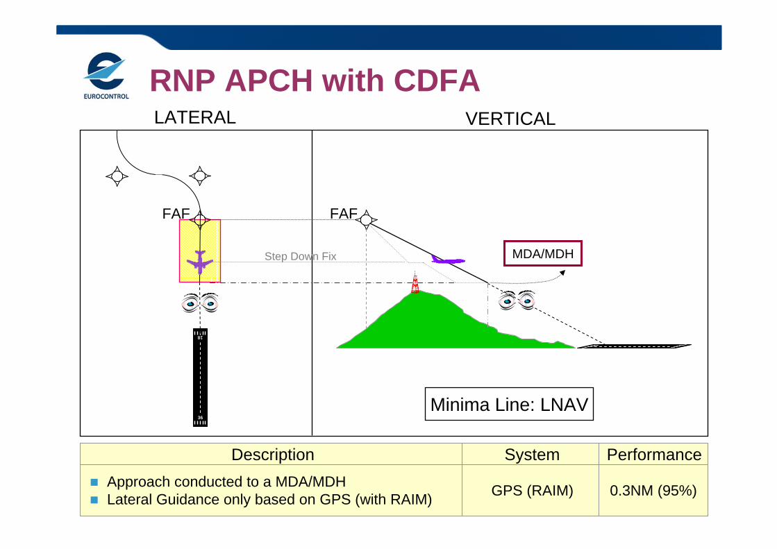
RNP APCH with CDFALATERAL VERTICAL
Description System Performance
MDA/MDH
Approach conducted to a MDA/MDH Lateral Guidance only based on GPS (with RAIM) GPS (RAIM)
36
18FAFFAF
Minima Line: LNAV
Step Down Fix
12VNAV: 20-27
Baro VNAV
0.3NM (95%)
GPS
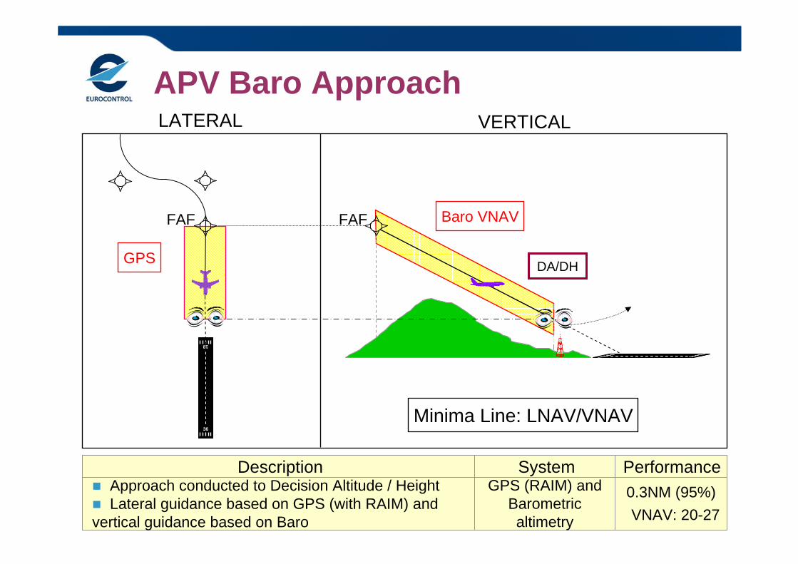
APV Baro ApproachLATERAL VERTICAL
Description System Performance
DA/DH
Approach conducted to Decision Altitude / Height Lateral guidance based on GPS (with RAIM) and vertical guidance based on Baro
GPS (RAIM) and Barometric altimetry
36
18FAFFAF
Minima Line: LNAV/VNAV
13
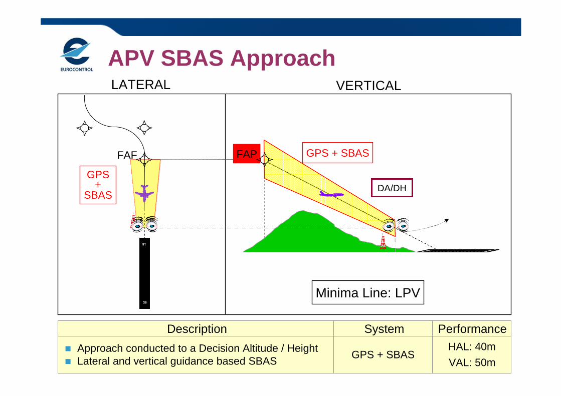
APV SBAS Approach
Description System Performance Approach conducted to a Decision Altitude / Height Lateral and vertical guidance based SBAS GPS + SBAS
HAL: 40m
GPS+
SBAS
LATERAL VERTICAL
DA/DH
36
18FAPFAF
Minima Line: LPV
VAL: 50m
GPS + SBAS
14
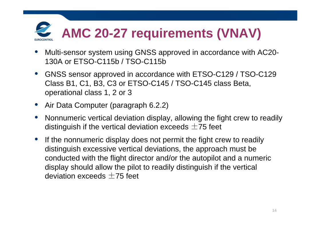
AMC 20-27 requirements (VNAV)• Multi-sensor system using GNSS approved in accordance with AC20-
130A or ETSO-C115b / TSO-C115b
• GNSS sensor approved in accordance with ETSO-C129 / TSO-C129 Class B1, C1, B3, C3 or ETSO-C145 / TSO-C145 class Beta, operational class 1, 2 or 3
• Air Data Computer (paragraph 6.2.2)
• Nonnumeric vertical deviation display, allowing the fight crew to readily distinguish if the vertical deviation exceeds ±75 feet
• If the nonnumeric display does not permit the fight crew to readily distinguish excessive vertical deviations, the approach must be conducted with the flight director and/or the autopilot and a numeric display should allow the pilot to readily distinguish if the vertical deviation exceeds ±75 feet
15
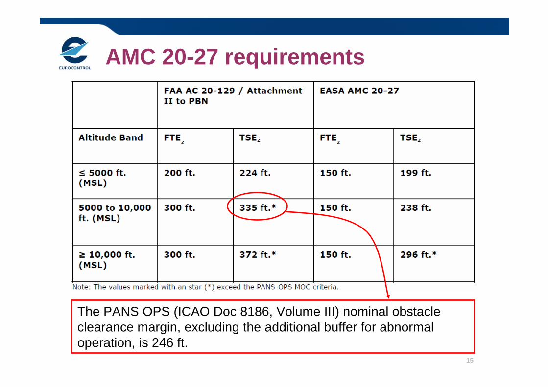
AMC 20-27 requirements
The PANS OPS (ICAO Doc 8186, Volume III) nominal obstacle clearance margin, excluding the additional buffer for abnormal operation, is 246 ft.

16
AMC 20-27 certification memo 1/2• EASA CM - AS – 002 Issue 01 Section 7: ACCEPTANCE OF
PREVIOUS DEMONSTRATION OF COMPLIANCE WITH FAA AC 20-129 FOR CREDIT FOR AMC 20-27 AIRWORTHINESS AND OPERATIONAL APPROVAL
The AFM should include a limitation that BARO-VNAV approaches to airfields at elevations above 5000 ft (MSL) are not permitted
• EASA CM - AS – 002 Issue 01 Section 5: THE USE OF GNSS/SBAS GEOMETRIC ALTITUDE AS A SOURCE OF ALTITUDE FOR APPROACHES TO LNAV/VNAV MINIMA
Standalone: ETSO-C146c Class Gamma, operational class 2 or class 3
Integrated: ETSO-C145c class Beta, operational class 2 or class 3
the flight crew should be able to retrieve an approach to LNAV/VNAV minima only when the approach has been appropriately coded, i.e. a GNSS/FMS indicator of ‘A’ in the ARINC 424 coded Navigation Database
17
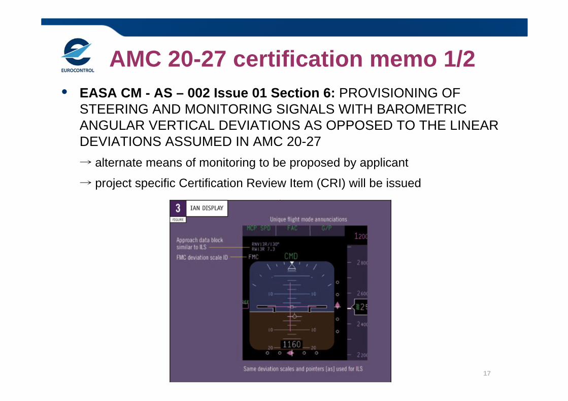
AMC 20-27 certification memo 1/2• EASA CM - AS – 002 Issue 01 Section 6: PROVISIONING OF
STEERING AND MONITORING SIGNALS WITH BAROMETRIC ANGULAR VERTICAL DEVIATIONS AS OPPOSED TO THE LINEAR DEVIATIONS ASSUMED IN AMC 20-27→ alternate means of monitoring to be proposed by applicant
→ project specific Certification Review Item (CRI) will be issued
18
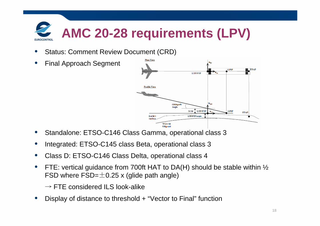
AMC 20-28 requirements (LPV)• Status: Comment Review Document (CRD)
• Final Approach Segment
• Standalone: ETSO-C146 Class Gamma, operational class 3
• Integrated: ETSO-C145 class Beta, operational class 3
• Class D: ETSO-C146 Class Delta, operational class 4
• FTE: vertical guidance from 700ft HAT to DA(H) should be stable within ½FSD where FSD=±0.25 x (glide path angle)
→ FTE considered ILS look-alike
• Display of distance to threshold + “Vector to Final” function
The case for RNP APCH• Safety
– Vertically guided approach allows stabilized approaches with standard crew ops procedures
• Reduces runway excursions caused by unstabilized approach– Improved situation awareness reduces CFIT risk– Reduced pilot workload compared to conventional step-down
approach and CDFA– Better obstacle design criteria
(low temperature protection in LNAV/VNAV procedure design)
• Improved Access– No dependence on ground based Navaids
• Low Cost • Reduced minima
– For example DH as low as 200ft based on SBAS LPV– Potential for straight-in instead of offset approach (due to reduced
obstacle clearance surfaces from RNP and/or lack of navaid siting problems)
20
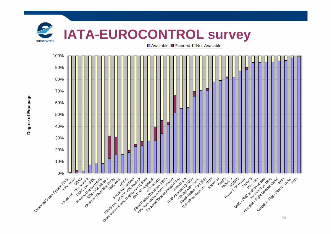
IATA-EUROCONTROL survey
0%
10%
20%
30%
40%
50%
60%
70%
80%
90%
100%
Enhan
ced V
ision
System
(EVS)
LPV S
BASGBAS
FANS 1/A - V
DL Mod
e 2
FANS 1/A H
FDL
Headu
p Disp
lay (H
UD)
ATN - VDL M
ode 2
Electro
nic Flig
ht Bag
(EFB)
FMS WPR
ADS-C
FANS 1/A SatC
om
FANS 1/A - A
CARS VDL M
ode A
Other M
ulti-F
uncti
on D
isplay
(MFD) fi
tted
RNP AR A
pproa
chADS-B
OUT
Fixed R
adius
Transit
ion (F
RT)
APV Baro V
NAV (LNAV - V
NAV)
Requir
ed Tim
e of A
rrival
(RTA)
ARINC 62
3
RNP App
roach
(LNAV)
8kHz3
3 VHF ra
dios
Fixed R
adius
Turn (R
F)
Multi M
ode R
eceiv
er - M
MRRNAV 10
GNSSMODE S
ACARS
RNAV 1 / P
-RNAV
RNAV 5IN
S - IRS
DME - DME po
sition
upda
te
Autothr
ust (A
-THR)
Autopil
ot - F
light
Directo
r VNAVEFIS
Autopil
ot - F
light
Directo
r LNAVFMS
Deg
ree
of E
quip
age
Available Planned Not Available
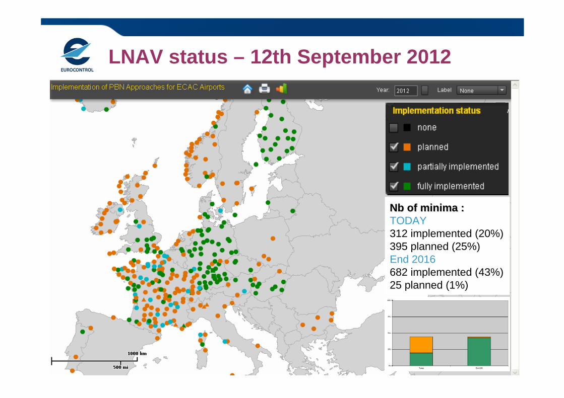
LNAV status – 12th September 2012
Nb of minima :Nb of minima :TODAY312 implemented (20%)395 planned (25%)End 2016682 implemented (43%)25 planned (1%)
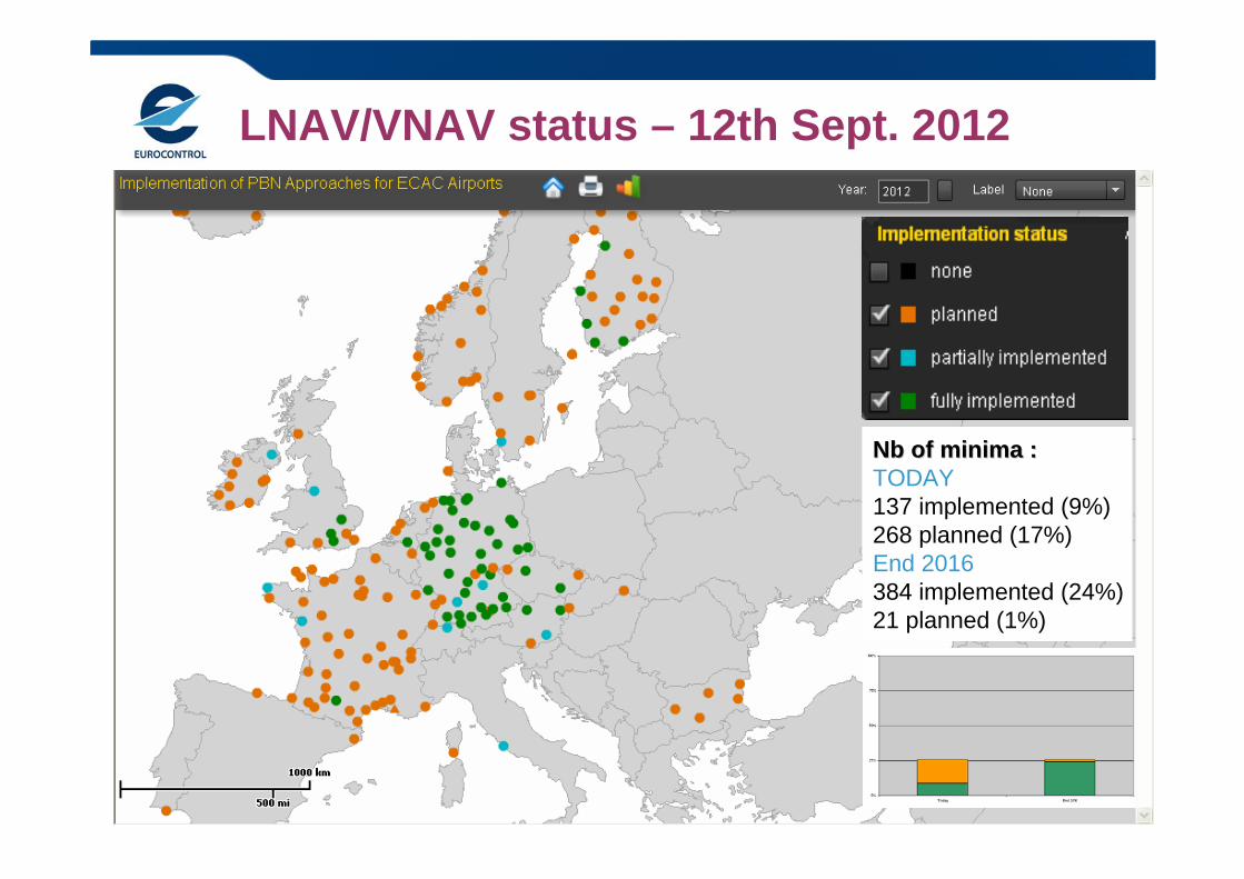
LNAV/VNAV status – 12th Sept. 2012
Nb of minima :Nb of minima :TODAY137 implemented (9%)268 planned (17%)End 2016384 implemented (24%)21 planned (1%)
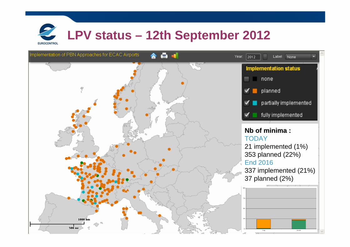
LPV status – 12th September 2012
Nb of minima :Nb of minima :TODAY21 implemented (1%)353 planned (22%)End 2016337 implemented (21%)37 planned (2%)
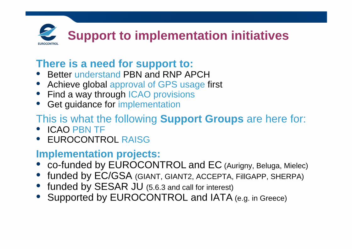
There is a need for support to:• Better understand PBN and RNP APCH• Achieve global approval of GPS usage first• Find a way through ICAO provisions• Get guidance for implementationThis is what the following Support Groups are here for:• ICAO PBN TF• EUROCONTROL RAISGImplementation projects:• co-funded by EUROCONTROL and EC (Aurigny, Beluga, Mielec)• funded by EC/GSA (GIANT, GIANT2, ACCEPTA, FillGAPP, SHERPA)• funded by SESAR JU (5.6.3 and call for interest)• Supported by EUROCONTROL and IATA (e.g. in Greece)
Support to implementation initiatives

EUROCONTROL PBN Approach Map Tool:
https://extranet.eurocontrol.int/http://prisme-newgis.hq.corp.eurocontrol.int/pbn/
QuestionsQuestions