vegetation survey - landcorp south/emu... · 4 1.5 vegetation from beard’s vegetation survey of...
TRANSCRIPT

VEGETATION SURVEY
LOTS 1512 & 1523 EMU POINT DRIVE, ALBANY, W.A.
A report prepared for
LandCorp
Western Australian Land Authority Level 3, Wesfarmers House, 40 The Esplanade, PERTH, WA 6000
October 2005

1
Table of Contents
EXECUTIVE SUMMARY 2
1. INTRODUCTION 3
1.1 Background
1.2 Location
1.3 Geology & Soils
1.4 Topography
1.5 Vegetation
1.6 Objectives
2. METHOD 5
2.1 Review of all relevant background information
2.2 Field Survey
3. RESULTS 7
3.1 Review of relevant background information
3.2 Vegetation Associations
3.3 Declared Rare & Priority Flora
3.4 Weeds & Diseases
3.5 Fauna & other significant features
4. CONCLUSION & RECOMMENDATIONS 11
4.1 Coastal Dune Management
4.2 Vegetation Management
4.3 Fire Management
4.4 Stormwater Drainage Management
5. REFERENCES 17
APPENDIX 1 Threatened Flora information
APPENDIX 2 Review data
APPENDIX 3 Survey Plot data
APPENDIX 4 Species list
Fig 1. Locality Map
Fig 2. Aerial Photos of site showing vegetation association.

2
EXECUTIVE SUMMARY
The vegetation surveyed in Lots 1512 and 1523 is Peppermint Thicket tending to Open
Peppermint heath and Sheoak woodland with Agonis flexuosa the dominant species
present. These vegetation associations are not classified as threatened ecological
communities however the conservation of the Sheoak woodland and of vegetation
containing the large old Banksia attenuata and B.ilicifolia is recommended.
One threatened flora species was found during this survey, Adenanthos cunninghamii, a
Priority Four Flora species. Plants of this species are scattered throughout the study
area. All effort should be taken to avoid removal of these plants however if it is
necessary then consultation and approval for their removal should be sought from the
local CALM District office.
The vegetation within the study area is in excellent condition however degradation by
weeds is evident particularly around the boundaries. Removal of existing weeds and
measures to suppress future weed invasion will retain conservation values of this area.
There is also a pocket of dieback infection present within the Sheoak woodland. Using
clean plant and machinery will minimize spread and introduction of diseases to the area.
These procedures are important to maintain and improve the conservation values of this
site.
Various fauna species were observed or evidence of their use of the sites was noted.
Retaining areas of habitat and particularly corridors of remnant vegetation such that
fauna can move freely between areas of remnant vegetation. Care should be taken
during development work to minimize hazards to fauna in the area.

3
1. INTRODUCTION
1.1 Background
Lots 1512 & 1523 are fully vegetated Lots situated on Emu Point Drive, Albany,
Western Australia. The land is state owned with a Management Order in favour of
the City of Albany for the purpose of Recreation/Parks & Reserves and zoned in the
City of Albany’s Town Planning Scheme No.1a as Future Urban.
LandCorp is in a position to acquire the land from the state with the approval of the
City of Albany and to plan, design and construct urban development on the land.
Prior to the commencement of any work on this development, there is a stipulation
to assess the vegetation that may be disturbed by this work. A vegetation survey was
conducted to examine possible ecological constraints to the proposed work.
1.2 Location
The study area is 34 hectares (Lot 1512 has an area of 26.8 hectares and Lot 1523
has an area of 7.2 hectares) and is located northeast of the Albany townsite. It is
bound by Emu Point Drive to the north, Middleton Beach and the coastal reserve to
the south, Griffith Street and residential development to the southwest and Emu
Point Motel and residential accommodation to the northeast (Fig 1.).
The study area is extensively covered with uncleared native vegetation, apart from a
dual use path that runs along the foreshore and a network of tracks that pass through
the property.
1.3 Geology and Soils
The study area consists predominantly of relict fore dunes. Parabolic and nested
parabolic dunes of the Quindalup Dune System exist along the foreshore, behind a
sandy beach. The relict fore dunes are composed of white medium-grained sand
with rounded quartz and shell debris. The Quindalup Dune System consists of sand
that is white, medium to coarse grained, moderately well sorted quartz and shell
debris.
1.4 Topography
The study area consists of low, undulating relict fore dunes and lunette topography.
The property ranges from 4m to 8m AHD and consists of several ridges and
depressions that run parallel to the beach. The terrain is considered flat with slopes
of less than three degrees. The foreshore consists of a continuous fore dune backed
by a relatively steep primary dune rising to between 4m and 8m AHD. A low
incipient dune exists behind a gently sloping beach that is approximately 30m wide.
4
1.5 Vegetation
From Beard’s Vegetation survey of Western Australia the area of investigation lies
in the Albany System of the Darling Botanical District. This system is located on
poorly drained plains stretching from Wilson Inlet to Oyster Harbour and includes
the town of Albany. The upland soils are excessively poor, leached and badly
drained, so more depauperate members of a low-forest mosaic are dominant,
Allocasuarina fraseriana on deep white sand, becoming mixed with Eucalyptus
staeri where it overlies laterite. The flat –bottomed valley floors drain south and
east and support dense reedy swamps. Granite domes north of Princess Royal
Harbour have remains of jarrah-marri forest, with mallee among the rocks at the
summit. Coastal dunes support mixed scrub heaths and shrubs.
From the Vegetation Survey of the Albany Hinterland by ATA Environmental in
2001 the study area lies in the Coastal Mallee – Heath D vegetation complex and
consists of coastal shrublands and heath on calcareous low plains (<15m elevation).
Species include Agonis flexuosa, Hakea suaveolens, Scaevola crassifolia, Olearia
axillaris, Phyllanthus calycina, various Epacridaceae and Myrtaceae.
1.6 Objectives
The main objectives of this vegetation survey are to:
� Carry out background research and acquire existing data from published
research regarding the particular site.
� Determine the floristic composition of the remnant vegetation present in the
study area, map these associations and comment on its local and regional
significance.
� Determine the presence of rare, endangered and/or priority flora species (as
listed on the 2001 Department of Conservation and Land Management –
CALM listing for flora species of conservation significance in Western
Australia).
� Determine the impact of weeds and disease as a result of disturbance of the
vegetation at the proposed site.
� Record opportunistic fauna sightings and other significant features.
� Recommend guidelines for coastal dune management (including pedestrian and
vehicle access and coastal reserve width), fire management, vegetation
management (including recommendations for public open space and vegetation
buffer locations) and stormwater drainage.

5
2. METHOD
2.1 Review of relevant background information
Below is a table of the information sourced for review and the authority from which
it was obtained.
Information & Reference material Source
Aerial photography City of Albany
DOLA
Vegetation and Flora surveys of the study area
or its surrounds
City of Albany
CALM
DOE
Guidance Position Statements No. 3 and No. 56 EPA
Threatened Flora and Communities data CALM
Guideline for Fire and Vegetation Management FESA
CALM
Guidelines for Coastal Reserve Management City of Albany
CALM
2.2 Field Survey
2.2.1 Vegetation communities & Species composition
On 6th
October 2005, a foot traverse through the site was conducted to ground truth
the vegetation associations present using aerial photography of the study area. This
initial survey allowed for a greater degree of familiarity with the site, including
access via existing tracks and the general condition of the site.
Once the vegetation associations were mapped, sites for the determination of the
species composition for each association were chosen. These sites were assessed on
the 11th
and 13th
October 2005 by establishing at least two 10m x 10m plots within
each vegetation association identified. Each plot was geographically located by GPS
at the northwest post and the plots were set out a north to south direction from this
marker post. Photographs of each plot were taken at the northwest post looking
southeast diagonally across each plot. Site data, vegetation structure and cover,
vegetation condition and species presence were recorded for each plot.
2.2.2 Declared Rare & Priority Flora
Under the Wildlife Conservation Act, the Department of Conservation and Land
Management is responsible for the protection of flora and fauna of all lands and
waters throughout the State. Section 23F of the Act gives the minister responsible
for the Act, statutory responsibility for the protection of those classes of flora
declared to be rare.

6
The Department of Conservation has ranked plant taxa considered to be threatened,
under a series of conservation codes, depending on their apparent degree of threat.
A Request for Rare Flora Information was made to the Species and Communities
Branch of the Department of Conservation and Land Management, Perth. The
search co-ordinates used were 34o59’ – 35o02’S and 117o 55’ – 117o58’E. The
results of this search are listed in Appendix 1.
The Environment Protection and Biodiversity Conservation Act 1999 (EPBC Act)
promotes the conservation of biodiversity by providing protection for listed species
and communities in Commonwealth areas. Threatened flora and fauna are listed
under the categories; Extinct, *Extinct in the wild, *Critically endangered,
*Endangered, *Vulnerable and Conservation dependent, as defined in Section 179
of the EPBC Act. Those species in the categories marked with an asterisk are of
national environmental significance under the EPBC Act.
The presence and location of any threatened species found during all visits to the
study area were recorded.
2.2.3 Weeds & Disease
The occurrence of weed species was noted during all site visits.
Observations for the presence of any dead plants, especially in the families
Proteaceae, Xanthorrhoeacece, Papilionaceae and Epacridaceae, were made during
the survey. These families are particularly susceptible to dieback diseases caused by
species of Phytophthora and also aerial cankers.
2.2.4 Fauna & other significant features
Opportunistic sightings of fauna or evidence of animal activity were recorded
during the survey.

7
3 RESULTS
3.1 Review of relevant background information
The local offices of the Department of Conservation and Land Management, the
Department of the Environment and the City of Albany were contacted to assess if
there were any previous surveys of this or surrounding areas contained within their
archives. The details of the reports reviewed are presented in Appendix 2. As a
result of this review it was determined that there is no significant research into the
vegetation of this particular site.
The Environmental assessment of Lot 1379 Barry Court, Albany and the Adjacent
Foreshore is the most significant published research pertinent to this study area as it
is adjacent to it and is assumed to contains similar vegetation. However this report
contains errors in species identification, particularly of dominant floristic
components such as Adenanthos cyngorum instead of Adenanthos sericeus.
The Perth office of the Environmental Protection Authority were contacted to
determine if they had received and assessed any environmental surveys of this area
or the surrounding environment, however a search of their archives produced no
resulting documents.
Copies of Position Statement No. 3 and Guidance for the Assessment of
Environmental Factors No. 51 and No. 56 were obtained from the Environmental
Protection Authority website www.epa.wa.gov.au. These documents were reviewed
such that this survey would comply with all relevant conditions.
3.2 Vegetation Associations
The review of the aerial photography and the ground truthing of that review
identified four vegetation associations within the study area. These are mapped in
Fig 2. The data collected from the survey plots set-up to assess vegetation structure
and cover, vegetation condition and species presence are presented in Appendix 3.
The location of each of the survey plots is shown on Fig 2.
The four vegetation associations identified within the study area are;
Sheoak Woodland (SW)
This vegetation association constitutes approximately 8% of the study area and was
found in the northeastern portion of the study area. It consists of open forest of
Allocasuarina fraseriana over tall open shrubland of Adenanthos sericeus and
Spyridium globulosum over open shrubland of Eutaxia obovata, Jacksonia horrida
and Leucopogon revolutus over low open shrubland of Acacia pulchella,
Adenanthos cuneatus and Dasypogon bromeliifolius over very open mixed herbs
over open mixed sedges.

8
Open Peppermint heath (OP)
This vegetation association is the largest component of the study area accounting for
50% of the area surveyed. It runs in a thick band from the corner of Emu Point
Drive and Griffiths Street to the eastern boundary of Lot 1523. This vegetation
association is a mosaic of four sub-categories;
1. Tall shrubland of Agonis flexuosa and Banksia ilicifolia over shrubland of
Bossiaea linophylla, Jacksonia horrida and Melaleuca striata over open low heath
of Dasypogon bromeliifolius, Leucopogon spp. and Pimelea rosea over very open
mixed herbland.
2. Very open tall shrubland of Agonis flexuosa over open heath of Jacksonia
horrida, Leucopogon revolutus and Melaleuca thymoides over open low heath of
Dasypogon bromeliifolius.
3. Tall shrubland of Agonis flexuosa and Banksia attenutata over tall open
shrubland of Adenanthos cuneatus, Hakea oleifolia and Spyridium globulosum over
open heath Acacia cochlearis, Jacksonia horrida and Leucopogon revolutus over
low open shrubland of Adenanthos cuneatus and Pimelea rosea over very open
mixed herbs over open sedgeland Desmocladus flexuosus, Lepidosperma squamata
and Lyginia barbata.
4. Very open tall shrubland of Agonis flexuosa over open shrubland of Melaleuca
thymoides over open low heath of Lysinema cilataum and Dasypogon bromeliifolius
over sedgeland of Lepidosperma squamata and Lyginia barbata.
Peppermint Thicket (PT)
This vegetation association is the second largest component accounting for 40% of
the study area. It has two sub-categories that run parallel to each other and to the
beach.
1. Thicket of Agonis flexuosa over tall open scrub of Acacia littorea and Spyridium
globulosum over shrubland of Acacia cochlearis, Hibbertia cuneformis and
Leucopogon parviflorus over sedgeland of Desmocladus flexuosa and
Lepidosperma costale.
2. Thicket of Agonis flexuosa over tall open scrub of Acacia littorea and Spyridium
globulosum over shrubland of Hibbertia cuneformis, Leucopogon parviflorus and
Phyllanthus calycina over sedgeland of Lepidosperma gladiatum.
Littoral Zone (LZ)
This vegetation association is only 2% of the study area and runs in a thin strip
along the beach. It is classified as closed low heath of Euphorbia paralias and
Pelargonium capitatum over very open grassland of Spinifex hirsutus and
Ammophila arenaria.

9
The full list of species present at each site is listed in Appendix 4.
The vegetation association identified within the study area extend beyond the
surveyed area such that the Sheoak Woodland is present on the north side of Emu
Point Drive where it has not been cleared for residential development. The Open
Peppermint heath extends east into Lot 1175 and the Peppermint Thicket and
Littoral Zone run parallel with the coast in both directions where they have not been
cleared for residential development.
3.2 Declared Rare & Priority Flora
No species of Threatened Flora identified from the Department of Conservation and
Land Management databases were found during this study. One species of
threatened flora Adenanthos cunninghamii (Albany Woollybush) was found during
this survey. Adenanthos cunninghamii was located in three separate locations across
the study area. Two plants were located in the Peppermint Thicket adjacent to
Griffiths Street, two plants were located east of firebreak off Emu Point Drive in the
Sheoak Woodland and one plant was located on the eastern boundary of the study
area in the Open Peppermint Woodland (Fig 2.).
3.3 Weeds & Diseases
Most vegetation associations are in excellent condition with all strata in the
associations intact and only a few species of common non-aggressive weed species
present. Such weeds are Ursinia (Ursinia anthemoides) and Flatweed (Hypochaeris
glabra).
However there are some areas where the more aggressive weed species are starting
to make an impact on the vegetation condition. Along Emu Point Drive the verge of
the study area has a varied intensity of infestation of Victorian Tee-tree
(Leptospermum laevigatum) and Watsonia (Watsonia bulbilifera). In the northwest
corner of the study area there are also some scattered plants of Sydney Wattle
(Acacia longifolia). Around the boundary of the Griffiths Street residential
development there are numerous garden escape species particularly Kikuyu
(Pennisetum clandestinum) (Fig 2.).
There is also a pocket of dieback infection within the Sheoak Woodland evident by
a number of freshly deceased plants from the Papilionaceae and Xanthorrhoeaceae
families.
3.2 Fauna & other significant features
No formal trapping program was conducted during this survey however
opportunistic sightings of fauna were recorded. Bandicoots (Isoodon obesulus) were
seen within the Peppermint Thicket and their diggings were evident across the study
area. A Motorbike Frog (Litoria moorei) was also seen in the Peppermint Thicket.

10
Tiger Snakes ( ) and Bobtails (Tiliqua rugosa) were disturbed in the Open
Peppermint Woodland and the Peppermint Thicket. Seven species of birds were
identified during the survey; Australian Raven (Corvus coronoides), Australian
Magpie (Gymnorhina tibicen), Mudlark (Grallina cyanoleuca), Silvereye
(Zosterops lateralis), New Holland Honeyeater (Phylidonyris novaehollandiae),
Red Wattlebird (Anthochaera carunculata) and Grey Fantail (Rhipidura fuliginosa).
The presents of Western Grey Kangaroos (Macropus fuliginosus) and Rabbits
(Oryctolagus cuniculus) was also evident by their scats. Give the nature of the
vegetation the Western Ringtail Possum (Pseudocheirus occidentalis) is a potential
inhabitant of the area.

11
4. CONCLUSION & RECOMMENDATIONS
4.1 Coastal Dune Management
Sandy coastlines are dynamic natural systems that change in shape and height over
varying periods of time. Coastal stability is a fundamental consideration in assessing
the impacts of a proposal on the foreshore environment and in determining the
width of coastal reserve necessary. Shoreline movements can be exacerbated by
man-made interruptions to natural processes. In considering stability it is important
to differentiate between long-term trends of erosion or accretion and the short-term
variability of a dynamic system.
Coastal stability predictions in Western Australia are based on Shoreline Movement
Plans derived from aerial photography. These plans show both the high water and
permanent vegetation lines for each year aerial photography is obtained. At present
little information is available on shoreline movement in the south coast. Assessment
of the coastal stability of the an area adjacent to this study area in 1995 showed the
shoreline has remained relatively stable for over 50 years, using aerial photography
from 1943-1994, except in the vicinity of the beach access paths. The path entrance
vegetation had receded by approximately 20m and a shift in the vegetation line is
evident for 20m to 25m on either side. This removal of vegetation is consistent with
human use with the exit uncontrolled by fencing.
Any subdivision of this study area will need to cater for access to the beach and
along the foreshore in a controlled manner to avoid causing damage to the fragile
dune system. The construction of path/s will need to consider number and location,
topography when deciding on path surfacing and the need for steps in order to
minimise erosion. Also fencing is now standard practice in coastal environments
and is necessary where random pedestrian access is likely to occur. Fencing along
the sides of existing beach access paths, as well as along the sides of new paths will
act to prevent degradation and aid in rehabilitation.
The condition of the primary dunes also provides evidence of coastal stability. In
the area of study these were extensively covered with well-established vegetation
and there is no evidence of cliffing associated with wave action.
In relation to coastal setback the Southern Shores strategy for 2001-2021 states;
“ New development on the coast will be separated from the established permanent
vegetation line by a managed foreshore reserve to a width which allows:
• natural coastal processes to occur;
• for sea level rise and coastal recession;
• for the movement of fauna and protection of stabilising vegetation;
• for the maintenance of visual amenity, natural view sheds and natural
contours; and
• for recreational needs and opportunities.”

12
The width of the coastal setback in this case will need to consider all these factors
particularly considering the fragility of these dunes if exposed and the presences of
native fauna.
4.2 Vegetation Management
Vegetation Associations
The study area is a series of relict coastal dunes that support mixed scrub heaths and
shrublands dominated by Peppermints (Agonis flexuosa) and changing to Sheoak
(Allocasuarina fraseriana) woodland further from the beach. These vegetation
associations are components of the Albany System as described by Beard and
correlate with those complexes expected in this area as described by ATA
Environmental. However there are some notable variations Hakea suaveolens is
replaced by Hakea oleifolia and Scaevola crassifolia is replaced by Scaevola nitida.
These vegetation associations are not classified as threatened ecological
communities, so this will not limit development of this site.
However the Sheoak Woodland is worth conserving. The biodiversity audit of
Western Australia’s biogeographical subregions carried out by the Department of
Conservation and Land Management in 2002 identified the sheoak communities
within the Southern Jarrah Forest subregion as in need of preservation. Most of
these communities have been cleared for agriculture and thus there is little or no
possibility of accruing these ecosystems to improve the reservation levels.
Maintaining this vegetation association at this site will aid in this. This example of
sheoak woodland is significantly different, as it is very close to the coast and has a
different set of associated understorey species. Its retention should at least form part
of the buffer required between the Emu Point Road and the proposed development.
The presence of large old Banksia attenuata and B.ilicifolia plants, throughout the
Open Peppermint vegetation association, also deserve consideration for
conservation within the development plan. Not only are they aesthetically pleasing
but representation of examples of this age and in such good health within the local
reserve system is low.
The coastal strip into which the study area falls is important as it forms part of an
almost unbroken coastal corridor of uncleared vegetation from Walpole east across
the region to the South Australian border. At present there is no regional strategy to
guide vegetation management of the coastal corridor so this may lead to continued
loss of small and large areas of significant vegetation important in the maintenance
of biodiversity values in the region (Southern Shores 2001-2021, 2001).
Threatened Flora
Albany woollybush (Adenanthos cunninghamii) was the only gazetted threatened
species of flora observed during this study. This species is generally found as rare
individuals scattered through populations of Coastal woollybush (Adenanthos
13
sericeus) and Coastal jugflower (Adenanthos cuneatus) along the coast from Sand
Patch in the west to Two Peoples Bay to the east and does not form homogenous
stands. This and the fact that the leaf form is somewhat intermediate between those
two species and it does not breed true to form suggest that this species is a hybrid.
This and the location of more populations in the late 90’s lead to its reclassification
from a Declared Rare Flora species to a Priority Four species. The five plants of this
species located during the study are in three locations. Due to the common
occurrence of the two companion species within the Sheoak Woodland, Open
Peppermint and Peppermint Thicket vegetation association there are likely to be
more scattered individuals of this species present in the study area.
In accordance with Section 23F of the Wildlife Conservation Act 1950 Ministerial
written consent is required to lawfully take declared rare flora and priority 1 and 2
flora .It is therefore customary for applications for a permit to take to be completed
and submitted for these categories of protected flora. The taking of Priority 3 and 4
flora species is discretionary, therefore a Ministerial permit is not required. Plants
may be taken following consultation and approval from the relevant CALM District
office. If the taking of plants can be avoided to minimize any losses or damage to
the population, then efforts should be made to do so.
Weed and Disease Management
The native vegetation within the study area is in excellent condition with all strata in
the associations intact and only a few species of common non-aggressive weed
species present.
However there are some areas where the more aggressive weed species are starting
to make an impact on the vegetation condition. Management of this existing weed
problem is essential and putting in place strategies to reduce the incidence of future
weed invasion is important.
The Victorian Tee-tree (Leptospermum laevigatum) and Watsonia (Watsonia
bulbilifera) along the verge of Emu Point Drive and the scattered occurrence of
Sydney Wattle (Acacia longifolia) in the northwest corner of the study area require
removal if any of this existing vegetation is to be preserved for conservation. The
Kikuyu (Pennisetum clandestinum) spreading into the remnant vegetation from the
residential properties off Griffiths Street also requires eradication to reduce the
impact on conservation values in this area. Removal of these weeds will avoid
large-scale weed control in the future. Techniques for the removal of these
particular species of weeds are described in Southern Weeds and Their Control
(Moore & Wheeler, 2002).
The plant disease known as ‘dieback’ has caused serious damage to woodlands and
heath lands in the southwest of Australia. Dieback is caused by Phytophthora spp.,
fungi which infect, rot the root system and subsequently kill the plant. About one
third of the flora in the southwest has the potential to be affected. Movement of
spores in water spreads the fungi, and movement of infected soil to uninfected

14
areas. Summer rains provide warm moist soil conditions, which favour the survival
and spread of these fungi.
Aerial cankers (Botryosphaeria, Diplodina) are more difficult to control as the
fungal spores are wind borne, attacking stems and leaves, and may ultimately cause
death. Historically their impact is less drastic than soil borne pathogens.
Areas of uninfected vegetation communities in the state remain important sites for
preservation. The presence or absence of these plant diseases is assessed using
indicator species. There is a pocket of dieback infection within the Sheoak
Woodland evident by a number of freshly deceased plants from the Papilionaceae
and Xanthorrhoeaceae families.
To minimise disease spread it is suggested that prior to commencing any works that
all vehicles, plant and machinery be thoroughly cleaned down by high-pressure
water or air blasting to remove all residual soil or plant material on or about the
mechanical parts or on cabin floors. All vehicles entering the sites should be water
blast cleaned if there is any doubt on underside cleanliness. Excavation and
earthmoving activities should be undertaken in dry soil conditions to minimise the
possible transference of soil borne phytopathogens.
In the event that sand fill is required, this material must be sourced from a
confirmed dieback disease free site or be tested to ensure that phytopathogens are
not introduced to the site that may have later implications for native vegetation of
the surrounding area.
Rehabilitation
It is recommended that areas that are identified for rehabilitation and revegetation
following development use locally species in the plantings.
Preparation work will be required to provide clean weed and disease free soil for the
planting. Weed matting or mulch should be placed over the exposed area to
minimize erosion and weed recruitment from the surrounding environment.
The original native habitat can be reintroduced to the area using local native
seedlings and/or local native seed mixes collected from the native species at the site
and within the immediate surrounds to allow for 700-1000g of seed per hectare. The
introduction of seeds or plants of unknown or not immediate local provenance is not
supported, as this is likely to introduce later problems with plant genetics in the
immediate locality.
The specific species use in the seed mixes for each vegetation association can
include the any of the species identified in the vegetation association descriptions.
The table below listed these specific species.

15
Sheoak Woodland Open Peppermint Heath Peppermint Thicket
Allocasuarina fraseriana
Adenanthos sericeus
Spyridium globulosum
Eutaxia obovata
Jacksonia horrida
Leucopogon revolutus
Acacia pulchella
Adenanthos cuneatus
Dasypogon bromeliifolius
Agonis flexuosa
Banksia ilicifolia
Banksia attenuata
Bossiaea linophylla
Jacksonia horrida
Melaleuca striata
Dasypogon bromeliifolius
Pimelea rosea
Leucopogon revolutus
Leucopogon aff. revolutus
Lysinema ciliatum
Melaleuca thymoides
Adenanthos cuneatus
Desmocladus flexuosa
Lepidosperma squamate
Lyginia barbata
Agonis flexuosa
Acacia littorea
Spyridium globulosum
Acacia cochlearis
Hibbertia cuneformis
Leucopogon parviflorus
Desmocladus flexuosa
Lepidosperma costale
Lepidosperma gladiatum
Phyllanthus calycina
The seed mixes are then broadcast over the site. Mixing the seeds with damp saw
dust helps in their dispersal. The timing of the rehabilitation work will directly
affect the recruitment success. The optimal time would be after the break of the
season to allow for sufficient moisture to be present but also at a time that there are
enough warm days to trigger germination.
Fauna
Although no formal trapping program was undertaken as part of this survey,
evidence of fauna species presence, as stated in the results, suggests that precautions
are required to prevent the threat of potential impacts on these fauna.
In particular the Western Ringtail Possum is a gazetted rare species and in need of
special protection under the provisions of the Wildlife Conservation Act 1950. This
species is restricted to the southwest of WA. It once occurred from near Geraldton
to the southern edge of the Nullabor Plain, and inland to the eastern Goldfields. It
now only remains in small parts of the jarrah forest near Manjimup and in coastal
forests and woodlands, especially of peppermint (Agonis flexuosa), from Busselton
to Albany. A major reason for its decline is habitat destruction.
As previously stated the importance of a sufficient coastal setback width is essential
for consideration of existing fauna activity in the area. Corridors of native
vegetation should be retained wherever possible to allow connectivity between
surrounding ‘islands’ of remnant vegetation.
Work on the development maybe hazardous to wildlife if trenches are left open
overnight or for a more extended period. An open trench will act as a pit trap for
small mammals, native reptiles and frog species.

16
Open trenches should therefore have means provided to assist any temporarily
trapped fauna to escape. This may include leaving gradual slopes of soil at the ends
of the trench and small tree branches temporarily placed on an angle in the trench to
assist climbing animals to escape.
A visual inspection of an open trench should be undertaken first thing in the
morning to ensure there is no fauna in the trench or to implement action to remove
any trapped wildlife, however this should be tempered with safety considerations if
venomous reptiles are involved. No animal should be destroyed unless it sustains
life-threatening injuries and recourse to veterinary treatment is unavailable or
impracticable. Any animal recovered from the trench must be released in the
immediate vicinity away from the construction site if they are in good health
4.3 Fire Management
In planning fire management for bushland areas it must be remembered that many
initiatives designed to reduce fire hazard also reduce environmental quality.
Similarly some initiatives to protect the environment can result in an increased fire
hazard. It is therefore important that all parties with a vested interest in the
management of the bushland are involved in planning the best possible solution to
this potential conflict.
Traditionally, as required by law, firebreaks have been ploughed or graded around
the edges of bushland, however because of the environmental importance of urban
bushland and in some cases its small area an alternative approach is to provide fire
access tracks in association with low-fuel areas. Fire access tracks are a disturbance
to the vegetation in bushland and any disturbance will encourage weed invasion, the
spread of dieback and cause other environmental problems.
Due to the long unburnt nature of the bushland as evident by the large old Banksias
in the area if any or all of the vegetation is retained for conservation purposes the
planning for fire management will need to take the above recommendations into
account. However as the area has not suffered from a fire in the recent past, control
burning is not a requirement for the vegetation management. The vegetation is very
healthy but the presence of weeds along the tracks means that if fire is used as a
management tool it will inevitably encourage the spread of these weeds into the
burnt areas when they are opened up by fire events.
4.4 Stormwater Drainage Management
There are no wetlands, sump land or damp land within the study area that will be
impacted by the proposed development. Stormwater discharge generated as a result
of the proposed subdivision road layout should be in accord with the guidelines for
Water Sensitive Urban Design. No stormwater should be directly discharged into
the foreshore reserve.

17
6. REFERENCES
ATA (2001). City of Albany: Vegetation Survey of the Albany Hinterland. ATA
Environmental Scientists, Dr Steven Connell.
Beard, J.S., (1990). Plant Life of Western Australia. Kangaroo Press, Kenthurst.
Blackall W.E. and B.J. Grieve, (1974). How to Know Western Australian Wildflowers, Part
I, II, III. University of Western Australia Press, Perth.
Blackall W.E. and B.J. Grieve, (1980). How to Know Western Australian Wildflowers, Part
IIIA. University of Western Australia Press, Perth.
Blackall W.E. and B.J. Grieve, (1981). How to Know Western Australian Wildflowers, Part
IIIB (Epacridaceae – Lamiaceae). University of Western Australia Press, Perth.
Blackall W.E. and B.J. Grieve, (1982). How to Know Western Australian Wildflowers, Part
IV. University of Western Australia Press, Perth.
Blackall W.E. and B.J. Grieve, (1988). How to Know Western Australian Wildflowers, Part
I Dicotyledons (Casuarinaceae – Chenopodiaceae). University of Western Australia Press,
Perth.
Blamey M. and C. Grey-Wilson, (1989). The Illustrated Flora of Britain and Northern
Europe. Hodder & Stoughton, London.
Brooker, M.I.H. and D.A. Kleing, (1990). Field Guide of Eucalyptus, South-western and
Southern Australia. Inkata Press, Melbourne.
Brown, A., Thomson-Dans, C. and N. Marchant, (1998). Western Australia’s Threatened
Flora. Department of Conservation and Land Management, Perth.
Burbidge, A.A., (2004) Threatened animals of Western Australia. Department of
Conservation and Land Management, Perth.
Grieve, B.J., (1998). How to know Western Australian Wildflowers, Part II, Dicotyledons
(Amaranthaceae to Lythraceae). University of Western Australia Press, Perth.
Henke, D. (2003). Lowlands Coastal Reserve Management Plan. City of Albany.
Hoffman, N. and A. Brown, (1992). Orchids of South-west Australia 2nd
ed. University of
Western Australia Press, Perth.
Hussey B.M.J., Keighery, G.J., Cousens, R.D., Dodd, J. and S.G. Lloyd, (1997). Western
Weeds, A guide to weeds of Western Australia. The Plant Protection Society of Western
Australia, Perth.

18
McKenzie, N.L., J.E. May & S. McKenna (2002) A Biodiversity Audit of Western
Australia’s 53 Biogeographic Subregions in 2002. Department of Conservation and Land
Management, Perth.
Meney K.A. and J.S. Pate, (1999). Australian Rushes. Biology, Identification and
Conservation of Restionaceae and Allied Families. University of Western Australia Press,
Perth.
Moore, J. and J. Wheeler (2002) Southern Weeds and their Control. Department of
Agriculture of Western Australia.
Sandiford E.M. (2000) Vegetation Survey of the Mt Martin Regional Botanic Park Albany.
City of Albany.
Sandiford E.M. (2002) Remnant Vegetation Program Community Quadrat Survey. City of
Albany.
Simpson K. and N. Day, (1996). Field Guide to the Birds of Australia. Viking, Melbourne.
Strahan R., (1991) Complete Book of Australian Mammals. Cornstalk Publishing, Sydney.
Wheeler, J., Marchant, N. and M. Lewington (2002) Flora of the South West, Volumes 1 &
2. University of Western Australia Press, Perth.


19
APPENDIX 1
THREATENED FLORA DATA

Your reference: Phone: 9334 0123 Our reference: 2005F001891VO5 Fax: 9334 0278 Enquiries: Kelly Poultney Email: [email protected]
Ellen Hickman 5 Harry Street ALBANY WA 6330 Dear Ms Hickman REQUEST FOR RARE FLORA INFORMATION I refer to your request of 3 October 2005 for information on rare flora in the Emu Point area, Albany. The search co-ordinates used were 340 59’ - 350 02’ S and 1170 55’ - 1170 58’ E. A search was undertaken for this area of (1) the Department's Threatened (Declared Rare) Flora database (for results, if any, see “Threatened Flora Data” – coordinates are GDA94), (2) the Western Australian Herbarium Specimen database for priority species opportunistically collected in the area of interest (for results, if any, see “WAHERB”- coordinates are GDA94 – see condition number 9 in the attached ‘Conditions in Respect of Supply’) and (3), the Department’s Declared Rare and Priority Flora List [there were no records on this database for the Emu Point area]. The results are attached electronically to this email. Attached also are the conditions under which this information has been supplied. Your attention is specifically drawn to the seventh point, which refers to the requirement to undertake field investigations for the accurate determination of rare flora occurrence at a site. The information supplied should be regarded as an indication only of the rare flora that may be present and may be used as a target list in any surveys undertaken. An invoice for $200 (plus GST) to supply this information will be forwarded. It would be appreciated if any populations of rare flora encountered by you in the area could be reported to this Department to ensure their ongoing management. Please note there has been an increase in proponents requesting searches using GIS shapefiles and the provision of information in electronic format that can be used in GIS applications (table formats). These searches are more labour intensive than standard searches, while being more economical for more complex searches. Consequently, there has been a change in the fee structure for the provision of rare flora information from the CALM datasets whereby GIS-based searches will attract a standard fee of $300 (plus GST). The fee for standard hard copy searches will remain unaltered. This fee structure commenced on 1 October 2004. If you require any further details, or wish to discuss rare flora management, please contact my Principal Botanist, Dr Ken Atkins, on (08) 9334 0425. Yours faithfully KPoultney .......................................... for Keiran McNamara EXECUTIVE DIRECTOR 29 November, 2007
SPECIES & COMMUNITIES BRANCH: 17 Dick Perry Ave, Technology Park, Kensington
Postal Address: Locked Bag 104, Bentley Delivery Centre, Bentley, Western Australia 6983
Phone: (08) 9334 0455 Fax: (08) 9334 0278 Website: www naturebase net

Summary of Threatened Flora DataOctober 6, 2005
Total No. of Records = 3
Page 1 of 1
Andersonia auriculata
Austrofestuca littoralis
Caladenia plicata
Species Name
2
1
4
Cons.
11
1
19
Pop ID
1000
No. Plants
34^59'49.6"
35^01'03.8"
34^59'25.6"
Latitude
117^56'46.5"
117^55'04.0"
117^56'20.5"
Longitude
Protection of Flora
Recreation
Protection of Flora
Purpose
SHI
SHI
SHI
Vest

06/10/05
1
WAHERB SPECIMEN DATABASE GENERAL ENQUIRY
Andersonia setifolia Benth. (Epacridaceae) CONSERVATION STATUS:P3 Coll.: E.M. Sandiford 85 Date: 19 08 1998 ( PERTH 05633990 ) LOCALITY By track to Waterfall Beach, 1.1Km WSW of Mount Martin, Mount Martin Botanic Park, Albany, WA LAT 35 Deg 0 Min 12.000 Sec S LONG 117 Deg 56 Min 55.000 Sec E Low semi-prostrate shrub with red flowers. On gentle southerly slope, soil a sandy gravel over granite. Bedrock outcropping on places. Vegetation, mixed scrub of Eucalyptus calophylla, Dryandra formosa, Hakea trifurcata, Acacia leioderma, Crowea angustifolia and Andersonia caerulea. Austrofestuca littoralis (Labill.) E.B.Alexeev (Poaceae) CONSERVATION STATUS:P1 Coll.: P.C. Heyligers 88127 Date: 08 09 1988 ( PERTH 02239035 ) LOCALITY Middleton Beach, E of Albany WA LAT 35 Deg 0 Min Sec S LONG 117 Deg 55 Min Sec E Tussock grass. Unstable foredunes, including restoration areas. With Ammophila arenaria (planted), Spinifex hirsutus, Cakile maritima, Euphorbia paralias, Arctotheca populifolia, Carpobrotus virescens, Pelargomium capitatum and Senecio elegans. Previous det.: Austrofestuca pubinervis (Vickery)B.K.Simon Austrofestuca littoralis (Labill.) E.B.Alexeev (Poaceae) CONSERVATION STATUS:P1 Coll.: J.A. Cochrane JAC 3788 Date: 10 12 2000 ( PERTH 05814626 ) LOCALITY Middleton Beach, on foredune past the caravan park for ca 1 km towards Emu Point, WA LAT 35 Deg 1 Min 4.600 Sec S LONG 117 Deg 55 Min 0.500 Sec E Tussock grass to 40 cm with golden fruiting heads to 15 cm tall. Beach dune with white sand. Dune. Associated species: Arctotheca populifolia, Euphorbia paralias, Cakile maritima, Ammophila arenaria. Some clumps very large with multiple stems and others small with only a few stems. Frequency:1000+ plants.
Banksia brownii R.Br. (Proteaceae) CONSERVATION STATUS:R Coll.: A. Cunningham s n. Date: ( PERTH 0998656 ) LOCALITY N of King George's Sound. WA LAT 35 Deg 0 Min Sec S LONG 117 Deg 58 Min Sec E Boronia crassipes Bartl. (Rutaceae) CONSERVATION STATUS:P3 Coll.: E. Hickman EJH 431 Date: 17 01 2001 ( PERTH 05846064 ) LOCALITY Creekline S of Warrangoo Road, E of Lound Street, Bayonet Head, Albany, WA LAT 34 Deg 59 Min 0.000 Sec S LONG 117 Deg 57 Min 0.000 Sec E Erect shrub 1.5 m high, 40 cm wide; few, pink flowers. Creekline. Surface not visible due to mass of Empodisma. Grey/brown sand/loam over peat. Sedgeland with Leptospermum firmum and Empodisma sp. Frequency:50+ plants. Chorizema reticulatum Meisn. (Papilionaceae) CONSERVATION STATUS:P3 Coll.: G.J. Keighery 8762 Date: 01 09 1986 ( PERTH 02724197 ) LOCALITY Bonnacord Road Reserve, 8 km ENE of Albany WA LAT 35 Deg 0 Min 14.000 Sec S LONG 117 Deg 57 Min 20.000 Sec E Tufted shrub, 10-20 cm high. Flowers salmon pink, eye yellow. Hilltop. Lateritic sand over laterite. Eucalyptus staeri woodland. Abundance: common. Previous det.: Chorizema sp. Melaleuca diosmifolia Andrews (Myrtaceae) CONSERVATION STATUS:P3 Coll.: E.J. Croxford 6522 Date: 21 05 1991 ( PERTH 04314239 ) LOCALITY Bayonet Head, Oyster Harbour, E of Albany, WA LAT 34 Deg 59 Min 0.000 Sec S LONG 117 Deg 56 Min 0.000 Sec E 1.5 m plant with greenish yellow flowers. Soil, sandy. In association with Eucalyptus sp. and Allocasuarina sp. This specimen is housed at Albany. Melaleuca diosmifolia Andrews (Myrtaceae)

06/10/05
2
CONSERVATION STATUS:P3 Coll.: E.M. Sandiford EMS 377 B Date: 03 08 1999 ( PERTH 05713633 ) LOCALITY Quadrat 12, below Whale Lookout, Mount Dennis, Mount Martin Regional Botanic Park WA LAT 35 Deg 0 Min 40.000 Sec S LONG 117 Deg 57 Min 40.000 Sec E Straggly bush to 0.8m Skeletal clay loam over exposed gneiss. Low open shrubland over open sedgeland with Lhotzkia acutifolia, Andersonia sprengeloides, Lepidosperma squamatum, Mesomelaena stygia and Conostylis setigera. Frequency:sporadic. Melaleuca incana subsp. tenella (Benth.) Barlow (Myrtaceae) CONSERVATION STATUS:P3 Coll.: E.M. Sandiford EMS 393 Date: 28 08 1999 ( PERTH 05713641 ) LOCALITY Coal Basket Bay, Mount Martin Regional Botanic Park WA LAT 35 Deg 0 Min 50.000 Sec S LONG 117 Deg 57 Min 50.000 Sec E Tangled shrub to 0.6 x 2m with no evidence of fruiting. Sand with organic matter among gneiss boulders. Shrubland at very edge of land above boulders with Leucopogon revolutis, Callistachys lanceolata and Scirpus nodosus. Frequency:few individuals. Stylidium plantagineum Sond. (Stylidiaceae) CONSERVATION STATUS:P4 Coll.: E.J. Croxford 5757 Date: 04 12 1987 ( PERTH 04548264 ) LOCALITY Below lookout, Bayonet Head, off Lower King Road, Albany, WA LAT 34 Deg 59 Min 0.000 Sec S LONG 117 Deg 56 Min 0.000 Sec E 40 cm plant with pale mauve flowers. Soil, red loam. In association with Allocasuarina sp. and Banksia sp. This specimen is housed at Albany. ALB. 10275 Thomasia discolor Steud. (Sterculiaceae) CONSERVATION STATUS:P3 Coll.: C. Andrews s.n. Date: ( PERTH 1062816 ) LOCALITY Middleton Beach, Albany WA LAT 35 Deg 0 Min Sec S LONG 117 Deg 55 Min Sec E Previous det.: Thomasia discolor Steud. Thomasia discolor Steud. (Sterculiaceae)
CONSERVATION STATUS:P3 Coll.: C. Andrews s n. Date: ( PERTH 1062786 ) LOCALITY Middleton Beach, Albany WA LAT 35 Deg 0 Min Sec S LONG 117 Deg 55 Min Sec E Previous det.: Thomasia discolor Steud. Thysanotus isantherus R.Br. (Anthericaceae) CONSERVATION STATUS:P3 Coll.: E.M. Sandiford EMS 456 Date: 17 10 1999 ( PERTH 05713277 ) LOCALITY Gneiss exposure near beach west of Mount Martin, Mount Martin Regional Botanical Reserve WA LAT 35 Deg 0 Min 50.600 Sec S LONG 117 Deg 57 Min 2.500 Sec E Tufted herb to 10cm tall growing through moss. Growing in grey sand over gneiss on a flat rise behind the beach. Open mixed shrubland and moss sward. Growing in association with Andersonia sprengeloides, Lepidosperma sp., Rulingia cygnorum, Drosera menziesii and mosses.

DEPARTMENT OF CONSERVATION AND LAND MANAGEMENT RARE FLORA INFORMATION
CONDITIONS IN RESPECT OF SUPPLY OF INFORMATION 1. All requests for data to be made in writing to the Executive Director, Department of Conservation and
Land Management, Attention: Administrative Officer Flora, Wildlife Branch.
2. The data supplied may not be supplied to other organisations, nor be used for any purpose other than for the project for which they have been provided, without the prior written consent of the Executive Director, Department of Conservation and Land Management.
3. Specific locality information for Declared Rare Flora is regarded as confidential, and should be treated as such by receiving organisations. Specific locality information for DRF may not be used in public reports without the written permission of the Executive Director, Department of Conservation and Land Management. Publicly available reports may only show generalised locations or, where necessary, show specific locations without identifying species. The Department is to be contacted for guidance on the presentation of rare flora information.
4. Note that the Department of Conservation and Land Management respects the privacy of private landowners who may have rare flora on their property. Rare flora locations identified in the data as being on private property should be treated in confidence, and contact with property owners made through the Department of Conservation and Land Management.
5. Receiving organisations should note that while every effort has been made to prevent errors and omissions in the data provided, they may be present. The Department of Conservation and Land Management accepts no responsibility for this.
6. Receiving organisations must also recognise that the database is subject to continual updating and amendment, and such considerations should be taken into account by the user.
7. It should be noted that the supplied data do not necessarily represent a comprehensive listing of the rare flora of the area in question. Its comprehensiveness is dependant on the amount of survey carried out within the specified area. The receiving organisation should employ a botanist, if required, to undertake a survey of the area under consideration.
8. Acknowledgment of the Department of Conservation and Land Management as source of the data is to be made in any published material. Copies of all such publications are to be forwarded to the Department of Conservation and Land Management, Attention: Principal Botanist, Wildlife Branch.
9. The development of the PERTH Herbarium and its database was not originally intended for electronic mapping (eg. GIS ArcView). The latitude and longitude coordinates for each entry are not verified prior to being databased. It is only in recent times that collections have been submitted to PERTH with GPS recorded latitude and longitude coordinates. Therefore, be aware when using this data in ArcView that some records may not plot to the locality description given with each collection.

THE DEPARTMENT OF CONSERVATION AND LAND MANAGEMENT
DECLARED RARE AND PRIORITY FLORA LIST
for Western Australia
CONSERVATION CODES R: Declared Rare Flora - Extant Taxa
Taxa which have been adequately searched for and are deemed to be in the wild either rare, in danger of extinction, or otherwise in need of special protection, and have been gazetted as such.
X: Declared Rare Flora - Presumed Extinct Taxa
Taxa which have not been collected, or otherwise verified, over the past 50 years despite thorough searching, or of which all known wild populations have been destroyed more recently, and have been gazetted as such.
1: Priority One - Poorly known Taxa
Taxa which are known from one or a few (generally <5) populations which are under threat, either due to small population size, or being on lands under immediate threat, e.g. road verges, urban areas, farmland, active mineral leases, etc., or the plants are under threat, e.g. from disease, grazing by feral animals, etc. May include taxa with threatened populations on protected lands. Such taxa are under consideration for declaration as 'rare flora', but are in urgent need of further survey.
2: Priority Two - Poorly Known Taxa
Taxa which are known from one or a few (generally <5) populations, at least some of which are not believed to be under immediate threat (i.e. not currently endangered). Such taxa are under consideration for declaration as 'rare flora', but are in urgent need of further survey.
3: Priority Three - Poorly Known Taxa
Taxa which are known from several populations, and the taxa are not believed to be under immediate threat (i.e. not currently endangered), either due to the number of known populations (generally >5), or known populations being large, and either widespread or protected. Such taxa are under consideration for declaration as 'rare flora' but are in need of further survey.
4: Priority Four - Rare Taxa
Taxa which are considered to have been adequately surveyed and which, whilst being rare (in Australia), are not currently threatened by any identifiable factors. These taxa require monitoring every 5-10 years.

ABBREVIATIONS USED IN THREATENED FLORA DATABASE PRINTOUTS
29/11/07
VESTING AGR Chief Exec Dept of Agriculture ALT Aboriginal Land Trust BAP Baptist Union of WA Inc BSA Boy Scouts Association CC Conservation Comission – NPNCA - LFC CGT Crown Grant in Trust COM Commonwealth of Australia CRO Crown Freehold-Govt Ownership DOL Dept of Land Administration DPU Ministry for Planning EXD Exec Direc CALM FRE Freehold HOW Homeswest ILD Industrial Lands Develop. Auth JOI Joint Vesting-NPNCA & Shire LAC LandCorp LFC Lands and Forests Commission MAG Minister for Agriculture MED Ministry of Education MHE Minister for Health MIN Minister for Mines MPL Ministry for Planning MPR Minister for Prisons MRD Main Roads WA MTR Minister for Transport MWA Minister for Water Resources MWO Minister for Works NAT Natural Trust of Australia WA NON Not Vested NPN NPNCA OTH Other PRI Private RAI Westrail SEC Western Power SHI Shire SPC State Planning Commission TEL Telstra TGR Timber Govt Requirement TOW TOWN UNK Unknown WAT Water Corporation WEL Minister Community Welfare WRC Water & Rivers Commission XPL Ex-Pastoral Lease PURPOSES ABR Aboriginal Reserve AER Aerodrome CAM Camping CAR Caravan park CEM Cemetery CFA Conservation of Fauna CFF Conservation Of Flora & Fauna CFL Conservation of Flora CHU Church CPK Car Park COM Common CON Conservation Park DEF Defence DRA Drain EDE Educational Endowment EDU Educational purposes UWA ENE Enjoyment of Natural Environ. EXC Excepted from sale
EXL Exploration Lease EXP Experimental Farm FIR Firing Range FOR State Forest GHA Grain Handling GOL Golf GRA Gravel Pit GRE Green Belt GVT Government Requirements HAR Harbour Purposes HEP Heritage Purposes HER Heritage trail HOS Hospital KEN Kennels MIN Mining lease MUN Municipal Purposes NPK National Park NRE Nature Reserve OTH Other PAC Public access PAR Parkland (& Recreation) PAS Pastoral lease PFL Protection of Flora PIC Picnic ground PLA Plantation POS Public Open Space PPA Public parkland PRS Prison site PUT Public Utility QUA Quarry RAD Radio Station RAC Racecourse REC Recreation REH Rehabilitation RNP Re-establish Native Plants RRE Railway Reserve RUB Rubbish SAN Sand SCH School-site SET Settlers requirements SHI Shire Requirements SHO Showgrounds SNN Sanitary STO Stopping place TIM Timber TOU Tourism TOW Town-site TRA Training Ground TRI Trig station TVT Television transmitting UNK Unknown UTI Utilities VCL Vacant Crown Land VER Road Verge VPF Vermin Proof Fence WAT Water WCO Water & Conservation of F & F WOO Firewood ∗ Please note that LFC now comes under the Conservation Commission.

20
APPENDIX 2
REVIEW DATA

The following is a list of reports reviewed, their content and their relevance to the assessment of Lots 1512 & 1523 Emu Point Drive, Albany, 2005. Surveying Western Australia’s Land Edge (SWALE) 2 – Reference transects in coastal vegetation at Kalbarri, Mandurah and Albany, Western Australia by C. Tauss (2005). Content: The primary aim of this project is to record baseline data of flora and
vegetation in permanent representative transects at selected areas along the southwest WA coastline. Locations in Albany were Sharp Point, Torndirrup National Park; Goode Beach, Vancouver Peninsular National Park; Little Beach, Two People’s Bay National Park. Findings showed the Sharp Point site is a plateau with low-perched dunes truncated at the Southern Ocean by steep cliffs about 170m in height. Its geology is limestone over Proterzoic gneiss. The vegetation is low species-rich heath including Melaleuca pentagona, Templetonia retusa, Pultenaea quaerita, Gahnia sp. Headland and Desmocladus austrinus tending to closed scrub of Agonis flexuosa with Scaevloa nitida, Spyridium globulosum, Lepidosperma gladiatum and Acacia littorea and Banksia praemorsa and Adenanthos sericeus closed scrub furthest from the waters edge. The Goode Beach site is a tombolo with a fore dune on the ocean side and a rocky slope and perched dune towards the harbourside. The geology is Holocene quartz sand over estuarine and lagoon deposits and over Proterzoic gneiss. The vegetation is Adenanthos sericeus tall open shrubs over Pelargonium capitatum and naturalized alien herbs and grasses, tending to patchy Verticordia plumosa low shrubs with emergent Anthocersis viscosa, geophytes and annuals, to Darwinia diosmoides heath with Needhamiella pumilo and Stylidium repens, to Melaleuca thymoides heath with Anarthria scabra. The Little Beach site is a sheltered beach of rocky bay supratidal flat and paluslope seaward of a perched dune. The geology is Holocene peat and quartz sand over Proterzoic gneiss. The vegetation is Juncus kraussii grading to Baumea spp. sedgeland with emergent tall shrubs of Callistachys sp. South Coast, tending to species-rich heath including Melaleuca thymoides, Anarthria scabra and Cyathochaeta equitans.
Relevance: These surveys were also in coastal areas in the Albany region however the
findings were in completely different habitat to the study site of the Lots 1512 &1523 Emu Point Drive assessment.
Draft Management Plan – Tjuirtgellong Lake Seppings prepared by the Lake Seppings Bushcarers Group for Greenskills and the City of Albany (2001). Content: This report assesses the environment of Lake Seppings, concludes the
management issues and recommends mechanisms to reduce their threat. Lake Seppings is a wetland reserve southwest of the study area. The vegetation assemblages are broadly described as Kunzea heath; Beaufortia-

Agonis heath; Agonis forests and woodlands; Melaleuca woodlands and forests and Sedgelands. These vegetation assemblages form a mosaic within the reserve in response to both the undulating topography and patchy moisture distribution in the soil.
Relevance: The Lake Seppings Reserve lies adjacent to the study area however the
vegetation associations within it are completely different to those of the study site.
Vegetation Survey of the Mount Martin Regional Botanic Park, Albany by E.M. Sandiford (2000). Content: A survey of this 360 hectare reserve that identified 18 different vegetation
associations; 5 defined by the tree layer (T1-T5), nine defined by the dominant shrub (S1-S9) and 3 occur on rock exposures (R1-R3). All these vegetation associations except S1, are found to be common in the Albany area.
Relevance: The Mount Martin Regional Botanic Park is east of the study area across the
Oyster Harbour channel and has coastal habitat however none in common with the study site.
Remnant Vegetation Program Community Quadrat Surveys by E.M. Sandiford and Albany Branch of the Wildflower Society of Western Australia (2002). Content: Areas surveyed were Mt Martin Botanic Park, Betty’s Beach, Mt Melville
Reserve, Mt Clarence Reserve, Mutton Bird Reserve, Yakamia Creek Reserve, Bayonet Head Oyster Harbour and Gnowellen /Chillinup Roads.
Relevance: The assessments of the vegetation at the Mutton Bird Reserve shared some
correlation with the habitat at the study site however these habitats are grey sand and sandy loam over granite, which is not a component of Lots 1512 & 1523 Emu Point Drive.
Draft Coastal Management Strategy for City of Albany Reserves by Melanie Price for City of Albany Strategic Planning Team (2000). Content: The objective of this study were to work with the community to identify
coastal areas that are suitable for development, protection, recreation or require special care within the Albany region.
Relevance: This report contains specific information on the management of Middleton
Beach. The vision for this beach is a multiple use area to be managed for its visual amenity and high quality recreation values. This aims will need to be taken into account in the proposed development of the study area.

South Coast Regional Land and Water Care Strategy prepared by RAP & SCRIPT(1996). Content: This is a strategy to direct funding to priority issues of landcare. Relevance: No direct relevance. Southern Shores 2001-2021 by Barb Green for the South Coast Management Group (2001). Content: This is a strategy to guide coastal and marine planning and management in
the south coast region of Western Australia. Relevance: Important for guidelines to coastal dune management of this study site. Lowlands Coastal Reserve Management Plan prepared by David Henke (2003). Content: This is a plan to guide coastal and marine management within the Lowlands
Reserve. Relevance: As this is another coastal habitat in the Albany region it may have contained
similar habitat to the study site. No detailed vegetation assessment of the Lowlands Coastal Reserve was conducted as part of this plan so it correlation to the study area could not be assessed.
Fringing Estuarine Vegetation of Princess Royal Harbour by Luke Penn (1995). Content: This report assessed the vegetation within the harbour to determine the
vegetations associations and recommend guidelines for its conservation. Relevance: No correlating habitats. The Condition of the Kalgan River Foreshores 1992/93 by Luke Pen (1994). Content: This report assessed fringing vegetation of the Kalgan River and it
tributaries to determine its health and recommend management guidelines to improve its condition.
Relevance: No correlating habitats.

An Environmental Assessment of Lot 1397 Barry Court, Albany and the Adjacent Foreshore prepared by Alan Tingay & Associates (1995). Content: This environmental assessment was undertaken following a proposal by
Carine Nominees and Woodgrange Pty Ltd for a potential tourist/residential development on Lot 1397 Barry Court, Albany. This report provides an appraisal of the vegetation of the site, a discussion of environmental considerations and recommendations for management of the adjoining foreshore environment.
Relevance: This report is the most significant published research pertinent to this study
area as it is adjacent to it and is assumed to contain similar vegetation. However this report contains errors in species identification, particularly of dominant floristic components such as Adenanthos cyngorum instead of Adenanthos sericeus.
City of Albany: Vegetation Survey of the Albany Hinterland by ATA Environmental (2001). Content: The major objective of this report is to improve the knowledge of the
distribution and condition of native vegetation in the Albany Hinterland and to provide strategic direction and guidelines to enhance future management of native vegetation. This inventory identified 199 vegetation complexes within the Albany Hinterland and half of these (99) are poorly represented (<10%) in secure nature reserves.
Relevance: From this report the study area lies in the Coastal Mallee – Heath D
vegetation complex and consists of coastal shrublands and heath on calcareous low plains (<15m elevation). Species include Agonis flexuosa, Hakea suaveolens, Scaevola crassifolia, Olearia axillaris, Phyllanthus calycina, various Epacridaceae and Myrtaceae.


21
APPENDIX 3
SURVEY PLOT DATA

Location Road Location: Emu Point Drive Latitude: 35o00’00”S Site: 1 (Sheoak Woodland) Longitude: 117o55’54”E Vegetation Description Open forest of Allocasuarina fraseriana over tall open shrubland of Adenanthos sericeus and Spyridium globulosum over open shrubland of Eutaxia obovata, Jacksonia horrida and Leucopogon revolutus over low open shrubland of Acacia pulchella, Adenanthos cuneatus and Dasypogon bromeliifolius over very open mixed herbs over open mixed sedges.
Fig 3. View of survey plot 1 from the NW peg looking SE. Species Present in Plot Trees Allocasuarina fraseriana Lyperanthus serratus Shrubs Acacia pulchella Opercularia hispidula Adenanthos cuneatus Patersonia occidentalis Adenanthos cunninghamii Phlebocarya ciliata Adenanthos sericeus Phyllangium paradoxum Agonis flexuosa Pterostylis vittata Amperea ericoides Stylidium repens Boronia crenulata Thysanotus patersonii Dasypogon bromeliifolius Sedges Anarthria prolifera Eutaxia obovata Baumea juncea Gompholobium tomentosum Hypolaena exsulca Hibbertia furfuracea Lepidosperma squamata Hibbertia racemosa Lepidosperma sp. Jacksonia horrida Lyginia barbata Leucopogon revolutus Schoenus sublateralis Melaleuca striata Olax phyllanthi Opportunistic species Sollya heterophylla Anigozanthos flavidus Pimelea rosea Spyridium globulosum Caladenia pectinata Rhodanthe citrina Grasses Aira cupaniana Comesperma virgatum Schoenus curvifolius Herbs Caladenia flava Dampiera linearis Velleia trinervis Drosera erythrorhiza Leptospermum laevigatum Drosera macrantha Logania serpyllifolia Hydrocotyle alata Lomandra integra Isotropis cuneifolia Lysinema ciliatum
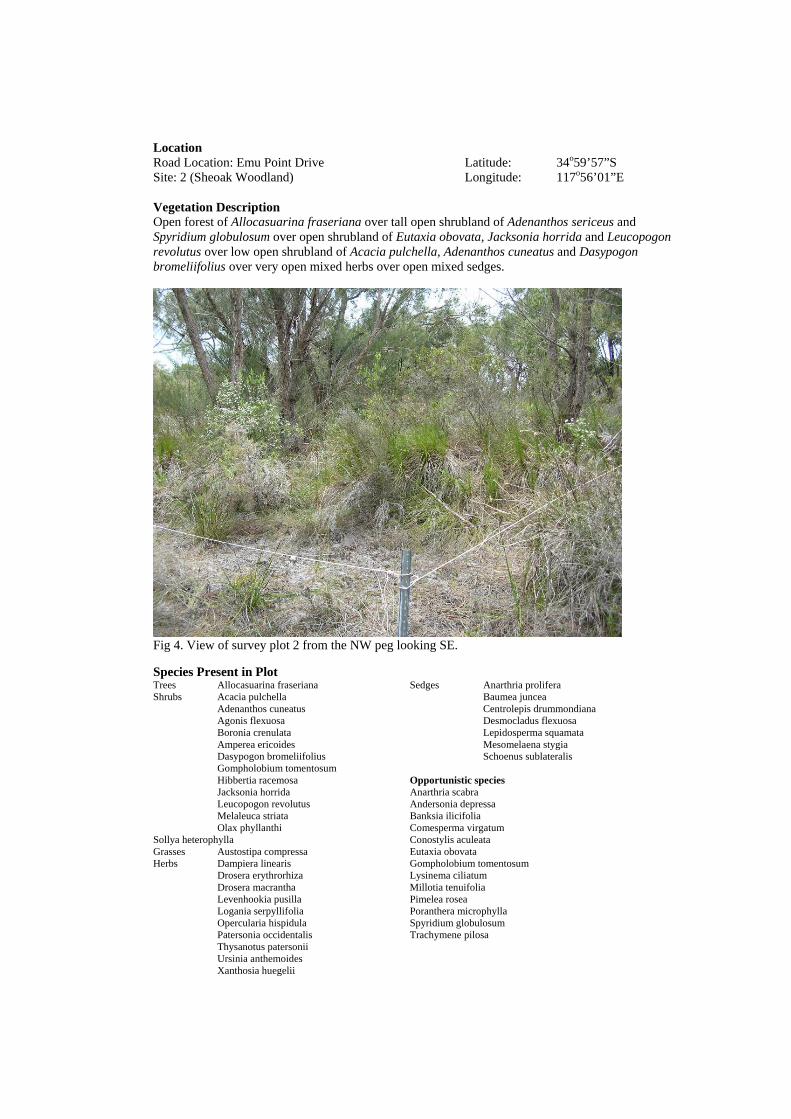
Location Road Location: Emu Point Drive Latitude: 34o59’57”S Site: 2 (Sheoak Woodland) Longitude: 117o56’01”E Vegetation Description Open forest of Allocasuarina fraseriana over tall open shrubland of Adenanthos sericeus and Spyridium globulosum over open shrubland of Eutaxia obovata, Jacksonia horrida and Leucopogon revolutus over low open shrubland of Acacia pulchella, Adenanthos cuneatus and Dasypogon bromeliifolius over very open mixed herbs over open mixed sedges.
Fig 4. View of survey plot 2 from the NW peg looking SE. Species Present in Plot Trees Allocasuarina fraseriana Sedges Anarthria prolifera Shrubs Acacia pulchella Baumea juncea Adenanthos cuneatus Centrolepis drummondiana Agonis flexuosa Desmocladus flexuosa Boronia crenulata Lepidosperma squamata Amperea ericoides Mesomelaena stygia Dasypogon bromeliifolius Schoenus sublateralis Gompholobium tomentosum Hibbertia racemosa Opportunistic species Jacksonia horrida Anarthria scabra Leucopogon revolutus Andersonia depressa Melaleuca striata Banksia ilicifolia Olax phyllanthi Comesperma virgatum Sollya heterophylla Conostylis aculeata Grasses Austostipa compressa Eutaxia obovata Herbs Dampiera linearis Gompholobium tomentosum Drosera erythrorhiza Lysinema ciliatum Drosera macrantha Millotia tenuifolia Levenhookia pusilla Pimelea rosea Logania serpyllifolia Poranthera microphylla Opercularia hispidula Spyridium globulosum Patersonia occidentalis Trachymene pilosa Thysanotus patersonii Ursinia anthemoides Xanthosia huegelii

Location Road Location: Emu Point Drive Latitude: 35o00’06”S Site: 3 (Open Peppermint) Longitude: 117o55’50”E Vegetation Description Tall shrubland of Agonis flexuosa and Banksia ilicifolia over shrubland of Bossiaea linophylla, Jacksonia horrida and Melaleuca striata over open low heath of Dasypogon bromeliifolius, Leucopogon spp. and Pimelea rosea over very open mixed herbland.
Fig 5. View of survey plot 3 from the NW peg looking SE. Species Present in Plot Shrubs Acacia pulchella Rhodanthe citrina Adenanthos cuneatus Xanthosia huegelii Agonis flexuosa Sedges Baumea juncea Banksia ilicifolia Desmocladus flexuosa Bossiaea linophylla Lepidosperma squamata Dasypogon bromeliifolius Lyginia barbata Gompholobium tomentosum Hardenbergia comptoniana Opportunistic species Hibbertia racemosa Acacia cochlearis Jacksonia horrida Adenanthos sericeus Leucopogon revolutus Allocasuarina fraseriana Leucopogon aff. revolutus Amperea ericoides Lysinema ciliata Banksia attenuata Melaleuca striata Caladenia flava Olax phyllanthi Hakea oleifolia Pimelea rosea Schoenus curvifolius Sollya heterophylla Thysanotus patersonii Spyridium globulosum Grasses Aira cupaniana Herbs Conostylis aculeata Drosera macrantha Isotropis cuneifolius Opercularia hispidula Patersonia occidentalis Phyllangium paradoxum

Location Road Location: Emu Point Drive Latitude: 35o00’10”S Site: 4 (Open Peppermint) Longitude: 117o55’43”E Vegetation Description Very open tall shrubland of Agonis flexuosa over open heath of Jacksonia horrida, Leucopogon revolutus and Melaleuca thymoides over open low heath of Dasypogon bromeliifolius.
Fig 6. View of survey plot 4 from the NW peg looking SE. Species Present in Plot Shrubs Acacia pulchella Sedges Desmocladus flexuosa Agonis flexuosa Lepidosperma squamata Comesperma virgatum Lyginia barbata Dasypogon bromeliifolius Schoenus curvifolius Gompholobium tomentosum Jacksonia horrida Opportunistic species Leucopogon revolutus Acacia longifolia Leucopogon aff. revolutus Adenanthos cuneatus Melaleuca striata Carpobrotus virescens Pimelea rosea Leptospermum laevigatum Sollya heterophylla Spyridium globulosum Grasses Aira cupaniana Briza maxima Centrolepis drummondiana Herbs Caladenia flava Conostylis aculeata Drosera erythrorhiza Drosera macrantha Hypochaeris glabra Lyperanthus serratus Opercularia hispidula Patersonia occidentalis Rhodanthe citrina Thysanotus patersonii Trachymene pilosa Ursinia anthemoides Xanthosia huegelii

Location Road Location: Emu Point Drive Latitude: 34o59’59”S Site: 5 (Open Peppermint) Longitude: 117o56’05”E Vegetation Description Tall shrubland of Agonis flexuosa and Banksia attenutata over tall open shrubland of Adenanthos cuneatus, Hakea oleifolia and Spyridium globulosum over open heath Acacia cochlearis, Jacksonia horrida and Leucopogon revolutus over low open shrubland of Adenanthos cuneatus and Pimelea rosea over very open mixed herbs over open sedgeland Desmocladus flexuosa, Lepidosperma squamata and Lyginia barbata.
Fig 7. View of survey plot 5 from the NW peg looking SE. Species Present in Plot Shrubs Acacia cochlearis Phyllangium paradoxum Acacia pulchella Rhodanthe citrina Agonis flexuosa Trachymene pilosa Adenanthos cuneatus Sedges Desmocladus flexuosa Adenanthos sericeus Lepidosperma squamata Amperea ericoides Lyginia barbata Astroloma pallidum Schoenus curvifolius Banksia attenuata Opportunistic species Comesperma virgatum Allocasuarina fraseriana Hakea oleifolia Andersonia depressa Hibbertia racemosa Anigozanthos flavidus Jacksonia horrida Hypochaeris glabra Leucopogon revolutus Hypolaena exsulca Melaleuca striata Pterostylis vittata Pimelea rosea Thysanotus patersonii Spyridium globulosum Grasses Aira cupaniana Herbs Conostylis aculeata Drosera erythrorhiza Drosera macrantha Isotropis cuneiformis Opercularia hispidula Pelargonium capitatum Petrorhagia velutina

Location Road Location: Emu Point Drive Latitude: 35o00’11”S Site: 6 (Peppermint Thicket) Longitude: 117o55’53”E Vegetation Description Thicket of Agonis flexuosa over tall open scrub of Acacia littorea and Spyridium globulosum over shrubland of Acacia cochlearis, Hibbertia cuneformis and Leucopogon parviflorus over sedgeland of Desmocladus flexuosa and Lepidosperma costale.
Fig 8. View of survey plot 6 from the NW peg looking SE. Species Present in Plot Shrubs Acacia cochlearis Opportunistic species Acacia littorea Bromus diandrus Agonis flexuosa Hakea oleifolia Clematis pubescens Heliophila pusilla Hardenbergia comptoniana Schoenus grandiflorus Hibbertia cuneformis Leucopogon parviflorus Phyllanthus calycina Rhagodia baccata Spyridium globulosum Grasses Poa poiformis Herbs Comesperma virgatum Dischisma arenaium Drosera macrantha Opercularia hispidula Sedges Desmocladus flexuosa Lepidosperma costale

Location Road Location: Emu Point Drive Latitude: 35o00’08”S Site: 7 (Peppermint Thicket) Longitude: 117o55’57”E Vegetation Description Thicket of Agonis flexuosa over tall open scrub of Acacia littorea and Spyridium globulosum over shrubland of Acacia cochlearis, Hibbertia cuneformis and Leucopogon parviflorus over sedgeland of Desmocladus flexuosa and Lepidosperma costale.
Fig 9. View of survey plot 7 from the NW peg looking SE. Species Present in Plot Shrubs Acacia cochlearis Opportunistic species Acacia littorea Hakea oleifolia Agonis flexuosa Leucopogon revolutus Clematis pubescens Phyllanthus calycina Comesperma virgatum Hardenbergia comptoniana Hibbertia cuneformis Leucopogon australis Rhagodia baccata Spyridium globulosum Herbs Caladenia latifolia Cyrtostylis huegelii Drosera macrantha Opercularia hispidula Thysanotus patersonii Sedges Desmocladus flexuosa Lepidosperma costale

Location Road Location: Emu Point Drive Latitude: 35o00’07”S Site: 8 (Open Peppermint) Longitude: 117o55’42”E Vegetation Description Very open tall shrubland of Agonis flexuosa over open shrubland of Melaleuca thymoides over open low heath of Lysinema cilataum and Dasypogon bromeliifolius over sedgeland of Lepidosperma squamata and Lyginia barbata.
Fig 10. View of survey plot 8 from the NW peg looking SE. Species Present in Plot Shrubs Acacia pulchella Opportunistic species Adenanthos cuneatus Agonis flexuosa Amperea ericoides Andersonia depressa Dasypogon bromeliifolius Astroloma pallidum Gompholobium tomentosum Drosera macrantha Leptospermum laevigatum Hibbertia racemosa Leucopogon revolutus Jacksonia horrida Lysinema ciliatum Microtis media Melaleuca thymoides Patersonia occidentalis Needhamiella pumilio Watsonia bulbillifera Herbs Johnsonia lupilina Opercularia hispidula Stylidium repens Stylidium violaceum Trachymene pilosa Sedges Hypolaena exsulca Lepidosperma squamata Lyginia barbata Schoenus curvifolius Schoenus sublateralis
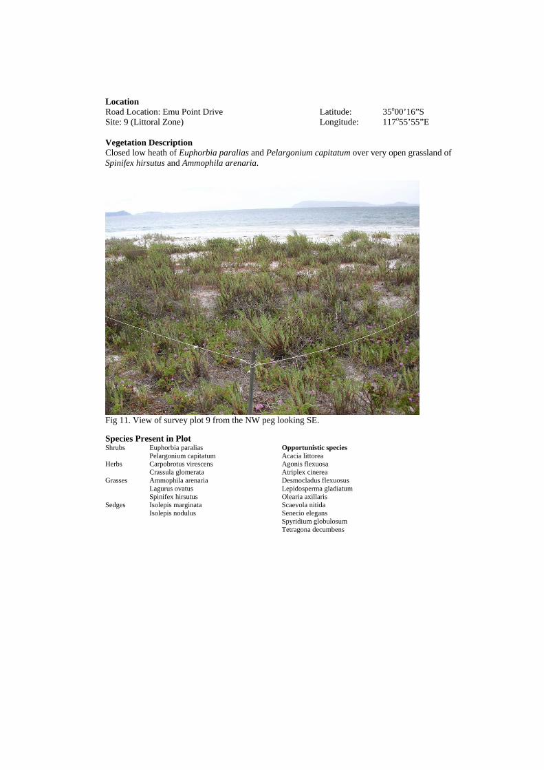
Location Road Location: Emu Point Drive Latitude: 35o00’16”S Site: 9 (Littoral Zone) Longitude: 117o55’55”E Vegetation Description Closed low heath of Euphorbia paralias and Pelargonium capitatum over very open grassland of Spinifex hirsutus and Ammophila arenaria.
Fig 11. View of survey plot 9 from the NW peg looking SE. Species Present in Plot Shrubs Euphorbia paralias Opportunistic species Pelargonium capitatum Acacia littorea Herbs Carpobrotus virescens Agonis flexuosa Crassula glomerata Atriplex cinerea Grasses Ammophila arenaria Desmocladus flexuosus Lagurus ovatus Lepidosperma gladiatum Spinifex hirsutus Olearia axillaris Sedges Isolepis marginata Scaevola nitida Isolepis nodulus Senecio elegans Spyridium globulosum Tetragona decumbens

Location Road Location: Emu Point Drive Latitude: 35o00’11”S Site: 10 (Littoral Zone) Longitude: 117o56’06”E Vegetation Description Closed low heath of Euphorbia paralias and Pelargonium capitatum over very open grassland of Spinifex hirsutus and Ammophila arenaria.
Fig 12. View of survey plot 10 from the NW peg looking SE. Species Present in Plot Shrubs Agonis flexuosa Opportunistic species Euphorbia paralias Acacia littorea Hibbertia cuneformis Leucopogon australis Pelargonium capitatum Olearia axillaris Herbs Crassula glomerata Spyridium globulosum Grasses Ammophila arenaria Lagurus ovatus Spinifex hirsutus Sedges Isolepis nodulus Lepidosperma gladiatum


22
APPENDIX 4
SPECIES LIST

Notes:
1 2 3 4 5 6 7 8 9 10Acacia cochlearis Rigid Wattle MIMOSACEAE Shrub * * * * CAcacia littorea MIMOSACEAE Shrub * * * * CAcacia longifolia * Sydney Golden Wattle MIMOSACEAE Shrub * UCAcacia pulchella Prickly Moses MIMOSACEAE Shrub * * * * * * CAdenanthos cuneatus Coastal Jugflower PROTEACEAE Shrub * * * * * * CAdenanthos cunninghamii P4 Albany Woollybush PROTEACEAE Shrub * RAdenanthos sericeus PROTEACEAE Shrub * * * VCAgonis flexuosa Peppermint MYRTACEAE Shrub * * * * * * * * * * VCAira cupaniana POACEAE Grass * * * * * CAllocasuarina fraseriana Sheoak CASUARINACEAE Tree * * * * CAmmophila arenaria Marram Grass POACEAE Grass * * CAmperea ericoides EUPHORBIACEAE Shrub * * * * * CAnarthria prolifera RESTIONACEAE Sedge * * CAnarthria scabra RESTIONACEAE Sedge * CAndersonia depressa EPACRIDACEAE Shrub * * * UCAnigozanthos flavidus Tall Kangaroo Paw HAEMODORACEAE Herb * * UCAstroloma baxteri EPACRIDACEAE Shrub * RAstroloma pallidum EPACRIDACEAE Shrub * CAtriplex cinerea Coastal Saltbush CHENOPODIACEAE Shrub * UCAustostipa compressa POACEAE Grass * UCBanksia attenuata Slender Banksia PROTEACEAE Shrub * * UCBanksia ilicifolia Holly-leaved Banksia PROTEACEAE Shrub * * UCBaumea juncea CYPERACEAE Sedge * * * C
1 2 3 4 5 6 7 8 9 10Boronia crenulata Aniseed Boronia RUTACEAE Shrub * * CBossiaea linophylla PAPILIONACEAE Shrub * CBriza maxima Blowfly Grass POACEAE Grass * UCBromus diandrus * Great Brome POACEAE Grass * UCCakile maritima Sea Rocket BRASSICACEAE Herb * * CCaladenia flava Cowslip Orchid ORCHIDACEAE Herb * * * UCCaladenia latifolia Pink Fairies ORCHIDACEAE Herb * UCCaladenia pectinata King Spider Orchid ORCHIDACEAE Herb * UC
Plant Form
Site No.
Abu
ndan
ceA
bund
ance
Family Plant FormSpecies Common Name
Site No.
Table showing species identified from vegetation survey of the Lots 1512 & 1523 Emu Point Drive Albany, WA
* - Weed species P4 - Priority Four Flora
Species Common Name Family
Abundance - Abundance of each species in the study area VC (very Common), C (Common), UC (Uncommon) and R (Rare).

Carpobrotus virescens Pigface AIZOACEAE Herb * * * UCCentrolepis drummundiana CENTROLEPIDACEAE Grass * * CClematis pubescens Common Clematis RANUNCULACEAE Creeper * * UCComesperma virgatum POLYGALACEAE Herb * * * * * * CConostylis aculeata Prickly Conostylis HAEMODORACEAE Herb * * * * CCrassula glomerata * CRASSULACEAE Herb * * CCyrtostylis huegelii Midge Orchid ORCHIDACEAE Herb * * RDampiera linearis GOODENIACEAE Herb * * UCDasypogon bromeliifolius DASYPOGONACEAE Shrub * * * * * VCDesmocladus flexuosus RESTIONACEAE Sedge * * * * * * * * VCDrosera erythrorhiza Red Ink Sundew DROSERACEAE Herb * * * * UCDrosera macrantha Bridal Rainbow DROSERACEAE Herb * * * * * * * * CEuphorbia paralias Sea Spurge EUPHORBIACEAE Shrub * * CEutaxia obovata PAPILIONACEAE Shrub * * UCGompholobium tomentosum Hairy Yellow Pea PAPILIONACEAE Shrub * * * * * UCHakea oleifolia Dungyn PROTEACEAE Shrub * * * * CHardenbergia comptoniana Native Wisteria PAPILIONACEAE Creeper * * * UCLevenhookia pusilla Midget Stylewort STYLIDIACEAE Herb * RHeliophila pusilla BRASSICACEAE Herb * UCHibbertia cuneiformis Cutleaf Hibbertia DILLENIACEAE Shrub * * * CHibbertia furfuracea DILLENIACEAE Shrub * UCDischisma arenarium * SCROPHULARIACEAE Herb * R
1 2 3 4 5 6 7 8 9 10Hibbertia racemosa Sta ked Guinea Flower DILLENIACEAE Shrub * * * * * CHydrocotyle alata APIACEAE Herb * RHypochaeris glabra * Flatweed ASTERACEAE Herb * * UCHypolaena exsulca RESTIONACEAE Sedge * * * CIsolepis marginata Coarse Club-rush CYPERACEAE Sedge * UCIsolepis nodosa Knotted Club-rush CYPERACEAE Sedge * * CIsotropis cuneifolia Granny Bonnets PAPILIONACEAE Herb * * * CJacksonia horrida PAPILIONACEAE Shrub * * * * * * VCJohnsonia lupilina Hooded Lily ANTHERICACEAE Herb * UCLagurus ovatus * Hare's Tail Grass POACEAE Grass * * UCLepidosperma costale CYPERACEAE Sedge * * * CLepidosperma gladiatum Coast Sword Sedge CYPERACEAE Sedge * * CLepidosperma squamata CYPERACEAE Sedge * * * * * * VCLeptospermum laevigatum * MYRTACEAE Shrub * * * CLeucopogon aff. revolutus EPACRIDACEAE Shrub * * CLeucopogon australis Spiked Beard Heath EPACRIDACEAE Shrub * UCLeucopogon parviflorus Coastal Beard Heath EPACRIDACEAE Shrub * * CLeucopogon revolutus EPACRIDACEAE Shrub * * * * * * * VCLogania serpyllifolia LOGANIACEAE Herb * * UCLomandra integra DASYPOGONACEAE Herb * UC
Species Common Name Family Plant Form
Abu
ndan
ce
Site No.

Lyginia barbata RESTIONACEAE Sedge * * * * * CLyperanthus serrata Rattle Beaks ORCHIDACEAE Herb * * UCLysinema ciliatum Curry Flower EPACRIDACEAE Shrub * * * * CMelaleuca thymoides MYRTACEAE Shrub * * * * * VCMesomelaena stygia CYPERACEAE Sedge * UCMicrotis media Common Mignonette Orc ORCHIDACEAE Herb * RMillotia tenuifolia Soft Millotia ASTERACEAE Herb * RNeedhamiella pumilio EPACRIDACEAE Shrub * COlax phyllanthi OLACACEAE Shrub * * * COlearia axillaris Coastal Daisy ASTERACEAE Shrub * * C
1 2 3 4 5 6 7 8 9 10Opercularia hispidula Hispid Stinkweed RUBIACEAE Herb * * * * * * * * CPatersonia occidentalis Purple Flag IRIDACEAE Herb * * * * * CPelargonium capitatum Rose Pelargonium GERANIACEAE Shrub * * * CPelargonium australe Wild Geranium GERANIACEAE Shrub UCPetrorhagia velutina * Velvet Pink CARYOPHYLLACEAE Herb * UCPhlebocarya ciliata HAEMODORACEAE Herb * UCPhyllangium paradoxum LOGANIACEAE Herb * * * UCPhyllanthus calycina False Boronia EUPHORBIACEAE Shrub * * CPimelea rosea Rose Banjine THYMELAEACEAE Shrub * * * * * VCPoa poiformis POACEAE Grass * CPoranthera microphylla Small-leaved Poranthera EUPHORBIACEAE Herb * CPterostylis vittata Banded Greenhood ORCHIDACEAE Herb * * UCPyrorchis forrestii Pink Beaks ORCHIDACEAE Herb * RRhagodia baccata Berry Saltbush CHENOPODIACEAE Shrub * * CRhodanthe citrina ASTERACEAE Herb * * * * CScaevola nitida Shining Fan Flower GOODENIACEAE Shrub * * CSchoenus curvifolius CYPERACEAE Sedge * * * * * CSchoenus grandiflorus Large Flowered Bog Rus CYPERACEAE Sedge * UCSchoenus sublateralis CYPERACEAE Sedge * * * CSenecio elegans Ragwort ASTERACEAE Herb * UCSollya heterophylla Australian Bluebell PITTOSPORACEAE Shrub * * * * CSpinifex hirsutus Hairy Spinifex POACEAE Grass * * CSpyridium globulosum Basket Bush RHAMNACEAE Herb * * * * * * * * * VCStylidium repens Matted Triggerplant STYLIDIACEAE Herb * * CStylidium violaceum Violet Triggerplant STYLIDIACEAE Herb * RTetragona decumbens * Sea Spinach AIZOACEAE Shrub * UCThelymitra crinita Blue Lady Orchid ORCHIDACEAE Herb *Thysanotus patersonii Twining Fringe Lily ANTHERICACEAE Herb * * * * * * CTrachymene pilosa Native Parsnip APIACEAE Herb * * * * CUrsinia anthemoides * Ursinia ASTERACEAE Herb * * C
Abu
ndan
ce
Species Common Name Family Plant Form
Site No.

1 2 3 4 5 6 7 8 9 10Velliea trinervis GOODENIACEAE Herb * UCWatsonia bulbillifera Bulbil Watsonia IRIDACEAE Herb * CXanthosia huegelii APIACEAE Herb * * * C
Abu
ndan
ce
Species Common Name Family Plant Form
Site No.