value-based pavement prioritization tool -...
TRANSCRIPT

Value-Based Pavement Prioritization Tool
11th National Conference on Transportation Asset Management Tim Skeel July 11, 2016

Acknowledgments • Pavement Group
– Sue Byers – Ben Hansen – Nataliya Dernbach
• Asset Management
– Tim Skeel – Terry Martin – Cathi Greenwood – Steve Barham
• GIS Group – Dana Trethewy – Jim Wiggins – Suzy Brunzell – Daniel Rockhold – Michael Davis
• Others – Craig Moore – King County GIS – Monica Schmitz
2

Presentation overview
• Background • Data process • Additional benefits • Caveats • “Beta-test” Findings • Next steps
3

Background – Impact of Paving Budget
4
Pavement Condition
Service Level Street Type Outcomes by
Budget
Good Service Level 1 (High Share of Total Budget)
High Traffic Volume
$$$ – More Lane-miles and Traveler-miles
$ – Fewer Lane-miles and Traveler-miles
Satisfactory
Fair
Poor Service Level 2
(Moderate Share of Total Budget)
Medium Traffic Volume
$$$ – Fewer Lane-miles and Traveler-miles
$ – More Lane-miles and Traveler-miles
Very Poor Service Level 3 (Low Share of Total Budget)
Low Traffic Volume
$$$ – Fewer Lane-miles and Traveler-miles
$ – More Lane-miles and Traveler-miles Serious/Failed
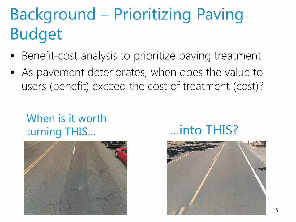
• Benefit-cost analysis to prioritize paving treatment • As pavement deteriorates, when does the value to
users (benefit) exceed the cost of treatment (cost)?
5
When is it worth turning THIS… …into THIS?
Background – Prioritizing Paving Budget

Background – Prioritize by B/C Ratio
6
e.g., E. Marginal Way
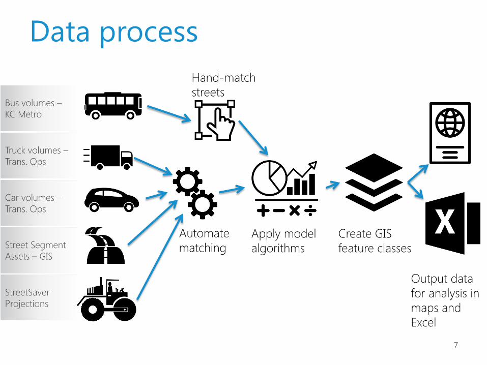
Data process
7
Apply model algorithms
Hand-match streets
Create GIS feature classes
Output data for analysis in maps and Excel
Automate matching
Bus volumes – KC Metro
Truck volumes – Trans. Ops
Car volumes – Trans. Ops
Street Segment Assets – GIS
StreetSaver Projections

8
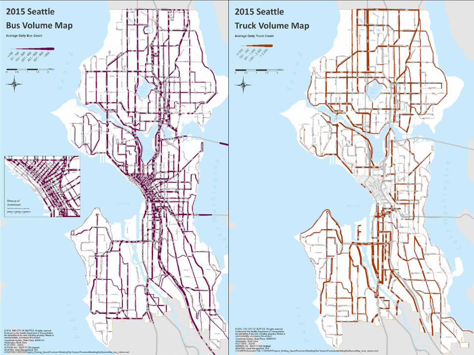
Vital Data – Car, Bus and Truck Volumes

Additional benefits
10
• GIS Layers – Passenger volumes on each street
• Car average daily traffic • Bus trip counts (ridership coming soon) • Truck average daily traffic
• Use Volume Data to – Plan projects – Rank streets by criticality
• Move Seattle Performance Metric – % of traveler-miles on fair or better streets due to
Move Seattle funding

Caveats
11
• Data on Traffic Volumes is Incomplete – Output will Change when Corrected
• May Find Hidden “Glitches” As Tool is Exercised • User Inputs (VOC, Treatment Costs, etc.) or
Asset Data (Condition, Type, etc.) Subject to Continuous Improvement
• It’s a Model, not Reality – Many Simplifying Assumptions. It Doesn’t Spit Out a Pavement Plan – It’s a Tool to Organize and Make Planning more Efficient and Objective
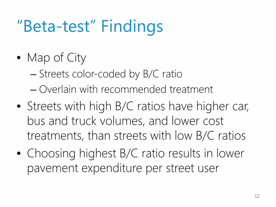
“Beta-test” Findings
12
• Map of City – Streets color-coded by B/C ratio – Overlain with recommended treatment
• Streets with high B/C ratios have higher car, bus and truck volumes, and lower cost treatments, than streets with low B/C ratios
• Choosing highest B/C ratio results in lower pavement expenditure per street user

Street Map B/C Ratios

14
10th Avenue East – Roy to Boston
$/Lane-mile Daily Cars
$3.7M 13,300 Daily Buses Daily Trucks
155 644
Treated
Untreated
Pavement Condition Index (PCI)

15
35th Avenue SW – Myrtle to Holden
Treated
Untreated
Pavement Condition Index (PCI) $/Lane-mile Daily Cars
$3.7M 21,300 Daily Buses Daily Trucks
183 370

16
East Marginal Way – Hudson to 1st Avenue
Treated
Untreated
Pavement Condition Index (PCI) $/Lane-mile Daily Cars
$0.85M 47,000 Daily Buses Daily Trucks
92 6,400

17
Comparison of Some Results

Treatment Type # Street Segments
Total Street Length (Miles)
Total Lane Miles
Average Treatment
Cost $/sq yd
Total Treatment
Cost
Average PCI Untreated
Average Daily
Vehicles
Average Daily Buses
Average Daily Trucks
Average B/C Ratio
$/ Traveler-mile
MILL AND THICK OVERLAY 58 4.8 14.5 $149 $ 15M 50 5,655 94 185 0.60 $0.046
MILL AND THIN OVERLAY 376 28.2 97.5 $120 $ 82M 50 9,340 79 398 1.23 $0.029
PARTIAL RECONSTRUCTION AC
461 35.6 117.6 $423 $355M 36
7,604
115
294
0.43 $0.109
PCC - SELECT PANEL REPLACEMENT 185 13.0 34.7 $125 $31M 50 4,092 70 156 0.62 $0.046
RECONSTRUCT STRUCTURE (AC) 661 51.9 132.4 $430 $404M 16 2,319 56 140 0.29 $0.238
RECONSTRUCT STRUCTURE (PCC) 587 41.7 142.0 $530 $530M 18 8,544 129 284 0.53 $0.123
Total 2,328 175.1 538.7 $373 $1,417M 29 6,297 92 251 0.57 $0.108
18
All Arterials with Paving Needs in 2016 – The “Backlog”

Treatment Type # Street Segments
Total Street Length (Miles)
Total Lane Miles
Average Treatment
Cost $/sq yd
Total Treatment
Cost
Average PCI Untreated
Average Daily
Vehicles
Average Daily Buses
Average Daily Trucks
Average B/C Ratio
$/ Traveler-mile
MILL AND THICK OVERLAY 13 1.2 4.6 $150 $5 50 15,646 163 580 1.50 $0.023
MILL AND THIN OVERLAY 157 12.4 44.4 $120 $38 50 17,876 102 821 2.10 $0.017
PARTIAL RECONSTRUCTION AC 30 2.9 7.0 $440 $22 35 21,913 163 671 1.37 $0.033
PCC - SELECT PANEL REPLACEMENT 32
2.2
7.0 $133 $7 51 18,263 130 478 1.75 $0.016
RECONSTRUCT STRUCTURE (AC) 26 2.2 4.0 $476 $13 13 17,912 192 649 1.63 $0.030
RECONSTRUCT STRUCTURE (PCC) 70 5.6 18.5 $530 $69 14 23,467 173 714 1.30 $0.051
Grand Total 328 26.5 85.6 $267 $153 38 19,391 135 728 1.76 $0.029
19
All Arterials with Paving Needs in 2016 w/ B/C > 1
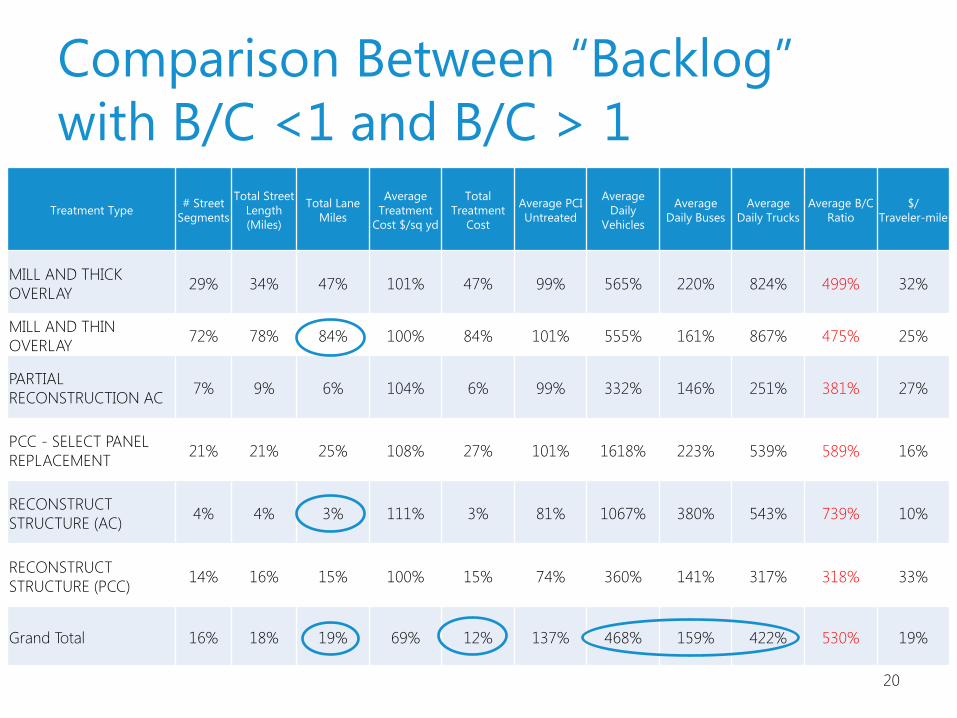
Treatment Type # Street Segments
Total Street Length (Miles)
Total Lane Miles
Average Treatment
Cost $/sq yd
Total Treatment
Cost
Average PCI Untreated
Average Daily
Vehicles
Average Daily Buses
Average Daily Trucks
Average B/C Ratio
$/ Traveler-mile
MILL AND THICK OVERLAY 29% 34% 47% 101% 47% 99% 565% 220% 824% 499% 32%
MILL AND THIN OVERLAY 72% 78% 84% 100% 84% 101% 555% 161% 867% 475% 25%
PARTIAL RECONSTRUCTION AC 7% 9% 6% 104% 6% 99% 332% 146% 251% 381% 27%
PCC - SELECT PANEL REPLACEMENT 21% 21% 25% 108% 27% 101% 1618% 223% 539% 589% 16%
RECONSTRUCT STRUCTURE (AC) 4% 4% 3% 111% 3% 81% 1067% 380% 543% 739% 10%
RECONSTRUCT STRUCTURE (PCC) 14% 16% 15% 100% 15% 74% 360% 141% 317% 318% 33%
Grand Total 16% 18% 19% 69% 12% 137% 468% 159% 422% 530% 19%
20
Comparison Between “Backlog” with B/C <1 and B/C > 1
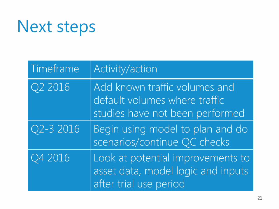
Next steps
Timeframe Activity/action
Q2 2016 Add known traffic volumes and default volumes where traffic studies have not been performed
Q2-3 2016 Begin using model to plan and do scenarios/continue QC checks
Q4 2016 Look at potential improvements to asset data, model logic and inputs after trial use period
21

Questions?
www.seattle.gov/transportation