using drones for disaster damage assessments...
TRANSCRIPT
Drones in Humanitarian ActionCase Study No.10: Monitoring and Inspection / Natural Disaster / Acute Emergency / Assessments
Using Drones for Disaster Damage Assessments in Vanuatu
Cyclone Pam struck Vanuatu and destroyed thousands of homes, schools and other buildings. The Humanitarian UAV Network carried out aerial surveys as the first operational project related to the World Bank UAVs for Resilience programme. The UAV team formulated standard operating procedures and coordination mechanisms, and carried out about 200 flights. Logistical and communication challenges, a lack of clarity about specific data requirements and the lack of a standardized file format limited the success of the project, but the drones mapped areas more quickly than any other available method, and the World Bank notes that extensive learning and insights were gained through the UAV mission.
Background
On 13 March 2015, tropical Cyclone Pam, a category 5 storm, struck Vanuatu, a collection of 82 islands that stretch across 1 300 kilometres, and became one of the worst natural disasters in the country’s history. Wind gusts reached as high as 320 km/hour destroying thousands of homes, schools and other buildings, leaving 16 people dead and displacing 3 300 people. The cyclone affected a total of 132 000 people, including 54 000 children. Within days the World Bank asked the Humanitarian UAV Network (UAViators) to carry out aerial surveys of as many disaster-affected areas as possible to supplement the post-disaster needs assessment. The Government of Vanuatu, through the South Pacific Commission, identified priority areas for the aerial surveys while carrying out their own initial damage assessments in the wake of Cyclone Pam. The priority areas were Shefa (Efate Urban, Efate Rural, Epi, Tongoa) and Tafea (Tanna, Erromango) and Malampa (Ambrym, Pentecost). The World Bank chose to use UAVs instead of helicopters due to the limited and unpredictable availability and cost of chartered helicopters in Vanuatu. In addition, producing high-resolution ortho-rectified mosaics requires specific flight plans and altitudes that are typically not achievable with helicopters. The purpose of the aerial surveys was to complement the field-based disaster damage assessments to identify which buildings were fully destroyed versus damaged but reparable versus largely intact. The mission was carried out between 28 March and 12 April 2015.
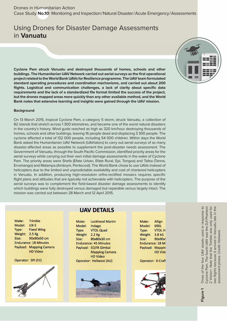
Figu
re 1
Th
ree
of t
he f
our
UAV
ass
ets
used
in r
espo
nse
to
Cyc
lone
Pam
. The
four
th U
AV w
as th
e D
JI P
hant
om
2 V
isio
n+. N
ote
that
the
Trim
ble
was
onl
y us
ed f
or
two
fligh
ts b
ecau
se it
arr
ived
in V
anua
tu la
te in
the
asse
ssm
ent p
hase
. Cre
dit:
Hel
iwes
t.
ImplementationWithin 48 hours of receiving the World Bank activation request, UAViators interviewed five professional UAV teams that are members of UAViators and listed on the network’s dedicated roster of UAV pilots. Heliwest from Australia and X-Craft from New Zealand were ultimately selected. Heliwest deployed a two-person team while X-Craft deployed a three-person team. UAViators served as the primary coordinator and liaison between the World Bank and the two UAV teams. The main UAV assets included a Lockheed Martin Indigo quadcopter, which has a flight time of 45 minutes; three Allign hexacopters, which have a flight time of 18 minutes; and two DJI Phantoms, which have a flight time of about 20 minutes.
Before the flights were conducted, the World Bank, the UAV operators, officials from the Government of Vanuatu and representatives of the Australian Defense Force and New Zealand Defense formulated standard operating procedures and coordination mechanisms for the operation of UAVs. They also identified government priorities for the initial survey areas. Government officials took responsibility for raising awareness of the scheduled flights in each of the target areas. All imagery was stored, processed and analysed using Dropbox, Pix4D, Mapbox, Humanitarian OpenStreetMap and MicroMappers.
In light of the congested airspace in and around the capital city of Port Vila, the project adopted the use of Extended Visual Line of Sight and several coordination mechanisms. The UAV teams operated as a single combined team that submitted their requested flight plans at 22:00 every night for the following day. The Australian Defense Force approved the flight plans by 23:00 (all requested UAV flights were approved). The UAV team then forwarded the approved flight plan to designated contacts at Air Traffic Control (ATC). The following day, if the plan called for operating in a complex airspace, the UAV team called ATC 10 minutes before launching the UAV and again right after landing the UAV in order to ask for clearance and to confirm that the UAV had landed. All UAV flights carried out in and around Port Vila were carried out before 8:00 every day due to the ATC restrictions on commercial and military aircraft operating in the early morning and due to the busy airspace thereafter. All UAVs were flown below 400 feet and most with line of sight. When cloud cover forced manned aircraft to fly below 1 000 feet, the UAV team discontinued operations immediately.
For some aerial surveys, the team flew all three assets at their disposal over the same areas. The DJI Phantom was flown at 200 feet to capture video, the Indigo UAV at 300 feet to capture nadir imagery and the Alliance at 400 feet to produce detailed 3D models. The combined UAV team carried out about 200 flights using all three UAV assets. The Heliwest Team flew a total of 126 flights, which together covered about 10 square kilometres. No incidents or accidents were reported throughout the two-week mission.
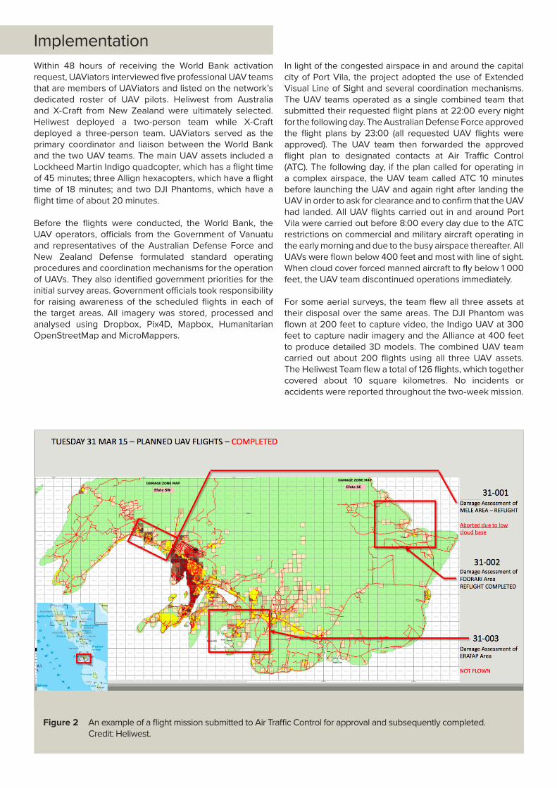
Figure 2 An example of a flight mission submitted to Air Traffic Control for approval and subsequently completed. Credit: Heliwest.

The project provided imagery to the World Bank and the Government of Vanuatu at the end of every day, and uploaded it to the cloud via Dropbox so that the Digital Humanitarian Network (DHN) could analyse it remotely under a Creative Commons licence. The primary information products included 2D ortho-rectified mosaics and oblique images. Two 3D models were created after the mission as a proof of concept. The 2D mosaics were analysed by the Humanitarian OpenStreetMap Team (HOT) while the 3 000+ oblique images were analysed by MicroMappers – both members of the DHN. A seasoned member of HOT analysed the 2D imagery by tracing which houses were fully destroyed, partially damaged or largely intact. This imagery and the resulting maps were hosted on Mapbox. The 3 000+ oblique images were uploaded to the free crowdsourcing platform MicroMappers in order to have these images traced along the same lines as the nadir imagery. Each image was shown to at least three different digital volunteers for
quality control purposes. All images were analysed within 72 hours. The resulting analyses from HOT and MicroMappers were then shared with the World Bank, who reported after the mission that the aerial imagery captured by the UAVs covered approximately 10 per cent of the disaster-affected area. A total of 65 aerial videos were also captured but were not used in the analysis because the World Bank and GIS teams on the ground did not have the time to analyse these additional data.
Figure 3 Analysis of oblique aerial imagery captured by the UAV teams. This analysis was carried out by Humanitarian OpenStreetMap. Red shelters are destroyed, yellow are partially damaged and blue largely intact.
Credit: Patrick Meier.

EvaluationAccording to the World Bank, the damage assessment teams used the drone imagery to verify the ground data and to estimate the costs of the damage. The Bank sees drones as an effective, low-cost means to carry out rapid post-disaster damage assessments immediately following an event. “Drones offer us a tech we can use immediately after a cyclone without waiting for the emergency response phase to be over before carrying out damage assessments. This is an innovative tool that the Bank team is eager to utilize during disaster events.”1
In addition, the Bank notes that Cyclone Pam was an exceptionally strong storm that triggered substantial international funding for damage assessments, but that the frequent smaller storms that occur every year require damage assessments for which funding is not generally available. Local drone capacity would allow the government to conduct rapid damage assessments at a low cost without the need to wait for international support.
Heliwest and X-Craft agree that the UAVs were not used to their full potential due to logistical and communication challenges. Securing transportation to move within islands was particularly challenging given the lack of available cars that could transport a five-person team with all the necessary UAV gear. Transportation between islands was also difficult due to the limited availability of helicopters, planes and boats, and, together with the absence of reliable and fast Internet connectivity, delayed the entire operation by several days.
The World Bank did not clearly specify the required level of spatial resolution for the imagery, which was collected at 4 cm on average. Resolutions of 10 cm or even 20 cm would have been sufficient and would have enabled a much larger geographical coverage of the disaster-affected areas. In addition, the oblique images were not automatically geo-referenced, and because the analytical results could not be integrated into the GIS analysis, the oblique imagery analysis may not have added any value to the World Bank assessment. According to both the UAV operators and UAViators, the lack of clarity about specific data requirements and the lack of a standardized file format for labelling the aerial imagery and videos limited the effectiveness of the project.
1 Personal correspondence with Tevi Obed, World Bank, 24 March 2016
The pressure on the UAV operators to get imagery processed in the evenings of the days of the flights meant that they often worked 20-hour days for several days in a row. This in part explains why the imagery was uploaded to HOT and MicroMappers for a crowdsourced analysis, which took several weeks. Still, according to the Heliwest Team, the specific objective of the humanitarian UAV mission was accomplished in that the drones mapped areas more quickly than any other available method. A Vanuatu government official directly involved in the UAV initiative noted at the time that he was pleased with the high-resolution aerial imagery of areas where it had previously been unavailable.
While the World Bank acknowledges that these problems did seriously limit the value that the UAVs could have had in Vanuatu, and that their current framework for the analysis of satellite imagery is simply too vague and subjective, it was nevertheless pleased with the extensive learning and insights that were gained through the UAV mission.
In any event, the World Bank notes that the aerial imagery analysis that was carried out on site and virtually by HOT did get integrated into the joint Post Disaster Needs Assessment, and the Government of Vanuatu now reports that all the aerial imagery is in their GIS systems for use as baseline data for future damage assessment efforts.
This UAV deployment in Vanuatu constituted the first operational project related to the World Bank UAVs for Resilience programme. The purpose of this programme is to use UAVs to build the resilience of Pacific Island States. The World Bank has drawn substantially on all the challenges and indeed failures of the Vanuatu mission to inform subsequent efforts of the UAVs for Resilience programme, which had been interrupted by the response to Cyclone Pam. These efforts are focused on carrying out UAV flight trials in mid-2016 in Vanuatu and Tonga using different UAVs to produce different information products. The purpose of these trials will be to identify which UAV is best for the Pacific Region and which types of information products add the most value for decision-making. In addition, the World Bank is drawing on the insights gained from the Vanuatu mission to improve their framework for analysing both aerial and satellite imagery for damage assessment.

Resources
http://iRevolutions.org/2015/03/29/pictures-uav-mission-cyclone-pam
https://micromappers.wordpress.com/2015/03/20/micromappers-vanuatu-response-completed
http://news.nationalgeographic.com/2015/04/150406-vanuatu-cyclone-pam-relief-drones-uavs-crisis-mapping-patrick-meier
http://www.wired.com/2015/05/cyclone-ravaged-vanuatu-drone-helps-survey-damage
http://www.irinnews.org/report/101362/drones-and-crisis-mapping-digital-aid-in-vanuatu
Technical Specifications & Credits
Type of system: Indago Multi-copter Microdrones by Lockheed Martin, 960L by Allign, Phantom 2 Vision+ by DJI and Fixed wing model UX-5 by TrimbleDeploying Agency: World BankPiloting Agency: Heliwest, Australia, and X-Craft, New Zealand, coordinated by UAViatorsDates of Deployment: 28 March to 12 April 2015Author: Patrick Meier, Denise Soesilo
With special thanks to: Tevi Obed (The World Bank) for his inputs and comments.
Swiss Foundation for Mine Action (FSD)7bis, Avenue de la Paix - Floor 2 CH-1202 GenevaSwitzerlanddrones.fsd.ch
Acronyms
ATC Air Traffic Control
DHN Digital Humanitarian Network
GIS Geographic information system
HOT Humanitarian OpenStreetMap Team
UAV Unmanned Aerial Vehicle
The views expressed herein should not be taken, in any way, to reflect the official opinion of the European Union, and the European Commission is not responsible for any use that may be made of the information it contains.