use of indigenous soil and water conservation practices ... · use of indigenous soil and water...
TRANSCRIPT
Indian Journal of Traditional Knowledge
Vol.12 (3), July 2013, pp 454-464
Use of indigenous soil and water conservation practices among farmers in
Sikkim Himalaya
P K Mishra & S C Rai*
Department of Geography, Delhi School of Economics, University of Delhi, Delhi-110007
E-mail: [email protected]
Received 10.10.11, revised 13.04.12
This paper analyses indigenous soil and water conservation practices in a watershed of Sikkim Himalaya based on
information collected through a questionnaire survey. Information used in the analysis were obtained through a survey of
150 farmers in 3 ecological zones (low, mid and high), group discussions, key informant interviews, and field observation
conducted during 2009-10. Farmers have adopted several conservation practices passed on to them by their forefathers.
Farmers in all ecological zones have practiced several structural and biological land management practices to conserve soil
and water. Adoption of terrace cultivation, construction of retention walls, bunds, construction and maintenance of
waterways, mixed cropping, crop rotation, mulching, agroforestry, and use of farm yard manure are found significantly
higher in all ecological zones of the watershed. This indicates that the farmers have very high belief in indigenous
techniques of conservation. Findings are discussed in the context of conservation programmes within the watershed. The
findings of this study have important policy implications for sustainable land management in the region.
Keywords: Land management, Structural measures, Biological measures, Watershed, Agroforestry, Sustainable
development, Soil erosion
IPC Int. Cl.8: A01, A01B, A01B 77/00, A01G 31/00, E02B 3/18, E02B 3/00, A01D, A23B, A01N 3/00, E02D 3/10, A01G
9/24, A01G 25/00, A01G 27/00
Land and water are the basic natural resources, which
support life in all forms. Both resources are limited to
meet the increasing demand for food, fuelwood and
timber in the world. Mountain watersheds have
attracted global concern due to the threat of serious
environmental and socio-economic implications
arising from natural resource degradation1. Erosion
of agricultural landscape is a significant socio-
environmental issue within the Himalayan region due
to on-site and off-site damages associated with soil
loss from land-use/cover change2,3
. Displaced soil
contributes to water pollution and reduces future
productivity of land resources that have a significant
environmental and socio-economic consequence for
society4.
The impacts of land degradation consist of two
types: on site and off site. A loss of productivity and
shortfalls in both food and cash crops are the
immediate impacts of land degradation. It is estimated
that 175 million ha of land in India suffers from
various problems of soil erosion and land
degradation5. This is all the more important because
the country looses about 5334 M tones (16.4 t/ha) of
soil annually. Of this, about 29% is carried away by
the rivers into the sea and 10% is deposited in the
reservoirs, resulting in a loss of 1 to 2% of their
storage capacity6. Short-sighted policy-makers and
planners find investments in conservation and
development of mountains less attractive compared to
the adjacent plains, as their comparative advantages
are overlooked. As a result, mountain watersheds are
either undergoing or are vulnerable to degradation,
despite local people’s efforts to prevent such effects7.
Traditional or indigenous technologies are entirely
based on local needs and surroundings, prepared from
locally available resources and from the wisdom and
knowledge handed down from generation to
generation. These are locally managed and
maintained. A few studies have shaded light on hills
farmers’ land management practices7,8,9
, but their
areas of concern have been selected aspects of
management including landslide prevention and repair
measures. Therefore, the objective of this paper is to:
(i) present the findings of a study designed to examine ——————
*Corresponding author
MISHRA & RAI: SOIL AND WATER CONSERVATION PRACTICES IN SIKKIM HIMALAYA
455
how indigenous practices influence adoption of
conservation systems at the farm level, (ii) find out
how hill farmers have changed their land management
practices to control land degradation under the
situation of steadily increasing population pressure on
very small landholdings, and (iii) document to serve
as a basis for programme planners to give such low
cost technologies their due importance. Study findings
are discussed in the context of conservation
programmes within the watershed.
Methodology
This study is based on information obtained
through a questionnaire survey, field observation, and
group discussions. The household survey was
conducted during study period (2009-10). A sample
size of 150 households was obtained from watershed
covering each ecological zone, viz. low, mid, and
high. Simple random sampling method was employed
to select households for the questionnaire survey. At
the outset, the interviewer introduced himself to the
villagers. Villagers were told about the nature of work
and assured that responses were to be used for
research purposes, that their cooperation to this effort
was sought, and confidentiality would be maintained.
Detailed information on the management practices of
each parcel of land owned by the sampled households
were collected using structured questionnaire.
Farmers were asked to complete a structured
questionnaire that required about 30 - 40 minutes to
complete. The response rate for each zone was about
80%. Average age of the respondents is 70 yrs. Given
the large sample size, the broad distribution of the
sample throughout the study watershed, the high
response rate, and the sampling technique used to
select the sample, the samples are assumed to be
representative of the farm populations within the each
ecological zone.
Information on soil and water conservation
practices including construction of terraces,
waterways, retention walls, gully control measures,
alley cropping, mulching and application of organic
manures was collected through household survey.
Besides, information on farmers’ experience in land
management, soil fertility and soil erosion was
collected through personal interview and group
discussion. The degree of adoption and diversity of
practices, however, vary from one farm household to
another, depending on their socio-economic condition
and biophysical characteristics of lands. To determine
the overall degree of adoption of soil and water
conservation measures, 16 common soil and water
conservation practices of farmers were selected. Hill
farmers have practiced different types of structural
and biological measures of soil and water
conservation to control erosion and landslide and
applied different types of fertilizers to maintain soil
fertility as summarized in Table 1.
Descriptive statistics were used to examine general
trends within the data set, while one-way analysis of
variance was used to test the research expectations
with the Statistical Package for Social Sciences
9 (SPSS) software. One way ANOVA analysis was
applied to analyses the significance difference of
indigenous SWC practices among different ecological
zones of the watershed. All the analysis was done at
0.05 or 5% level of significance.
Study area The study area Papung-Ben Khola watershed
located in the South district of Sikkim state was
selected for this study. This watershed extends
between 27° 13΄ 34˝ to 27°
16΄ 12˝ N and 88° 22΄ 18˝
to 88°27΄ 15˝ E. It is spread in 27.77 km2 area and
characterized by an elevational range of 326 to
2600 m asl. It comprises of most of the human
habitation zone, vegetation types and cropping
patterns that are common in the state. The watershed
is one of the most populated (10841 persons) areas in
state providing a wide range of cultural-ethnic
diversity and land-use pattern. Agricultural practices
extend from valley bottom to hilltop, with a variety
of cropping systems and management practices.
Fragmented into several parcels, farmlands are being
managed in different ways, to maximize benefits with
the limited amount of resources available to farmers.
The climate is monsoon type with average rainfall
was 3204 mm, and most of the rainfall takes place
during monsoon from June to September. Average
temperature ranges from 3-26°C.
Results and discussion
Structural measures of soil and water conservation
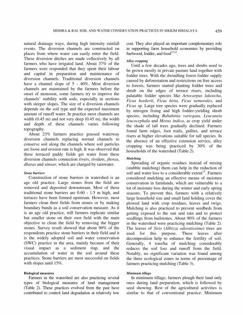
Terraces
Terraces are narrow strips of land carved out across
the hill slopes for cultivation of cereals, including
rice, maize, wheat and millet. Regardless of land type,
most terraces in the watershed were constructed long
back. Some of them were, however, constructed a few
decades ago in response to increasing food demand
INDIAN J TRADITIONAL KNOWLEDGE, VOL. 12, NO. 3, JULY 2013
456
for steadily growing household size. All respondents
in each ecological zone of the watershed responded
that they are practicing terraced farming since long
back (Table 2). There is no significant difference
between ecological zones in terms of percentage of
farmers who have terrace construction (Table 3).
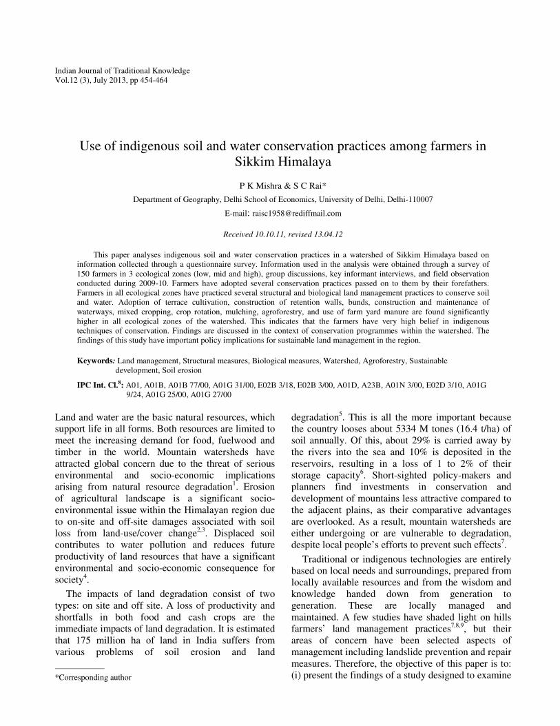
Leveled bench terraces (Fig.1a) are the dominant
structural measures adopted by hill farmers to
stabilize irrigation water required for rice cultivation
in Panikhet and Tarikhet. These terraces have been
maintained without any change in each ecological
zone. Bari terraces in the area have outward-facing
slopes that facilitate quick drainage of water required
for millet, maize and legume crops.
Terrace risers use to be relatively wide in the past
when the population pressure on land resources
was relatively low10
. Farmers have sliced terrace
risers to increase the area under crop production. Even
the tiny fraction of land under risers has been
intensively utilized for legume crops, which was not
the practice until few decades ago7. Similar results
were also recorded in the Papung-Ben Khola
watershed.
During field survey it was observed that about 23%
of the cultivated land is under leveled terrace and
used for paddy and other crops during monsoon
season. Most of the leveled terraces have a height of
2 - 5 m; width 2 - 5 m, and the length varies from
15 - 35 m. The width of the terrace is determined by
the slope (gradient) of the land. In the hill slope, an
average of 20 - 25 terraces exist, but in the lower
altitude a sequence includes not more than 10
terraces because of the larger width of the paddy
fields. Remaining 77% are sloping terraces. All
respondent of the area have agreed that terracing
is necessary, without which the plant nutrients
cannot be conserved and cultivation of crops are
impossible.
Table 1-Brief description of terminologies used in the context of hill farming system and soil and water conservation
Terminologies and measures Description
Hill slope Sloping land between valley floor and ridge
Terrace riser Steep slope between terrace of different altitude
Farm edge Farm boarder
Goth Makeshift livestock shed constructed in the farm terrace
Slicing terrace riser Thinly slicing of the slope between terrace by spade to remove weeds
and grasses
Panikhet Irrigated rice field located in the valley floors and foothills
Tarikhet Rainfed rice field located in the hill slope
Khet Common local term for both panikhet and tarikhet
Packo/Bari Rainfed maize and millet field
Terminologies used in the
context of hill farming
system
Gharbari Homestead used for fruit, maize, wheat, millet and vegetable production
Terrace Narrow strip of land carved out across the hill slopes for the cultivation of
cereals
Terrace bund An embankment at the outer edge of khet terrace made to control water flow
Contour bund An embankment built along the contour line to control soil erosion and siltation
Waterway Small canal at the inner toe of terraces made to convey runoff at a non-erosive
point
Retention wall A reinforced wall constructed to protect terrace riser from being collapsed
Alley cropping Alternate rows of field crops and perennials grown in a contour pattern in
sloping land
Shrub formations in
gullies
Bush formations, including bamboo, in gullies established to control gully
expansion in the hill slopes
Vegetative measures
of landslide control
Establishment of different shrubs and tree species with extensive root systems
for rehabilitation and control of landslides
Mulching The practicing of covering the plowed land by crop residues and leaf litters for
moisture and soil conservation
Farmyard manure Dung mixed with leaf litter and crop residues used for fertilizing land
Green manure Plant species containing soil nutrients
Measures of soil and water
conservation
Compost Decomposed mixture of organic materials, including manure, utilized for
fertilizing land

MISHRA & RAI: SOIL AND WATER CONSERVATION PRACTICES IN SIKKIM HIMALAYA
457
Bunds
Terrace bunds are small embankment constructed
at the outer edge of the terraces to control water flow.
Terrace bunds used to be relatively wide in the past
when the population pressure on land resources was
relatively low. Farmers have sliced terrace bunds to
increase the area under crop production. Even the tiny
fraction of land under bund has been intensively
utilized for legume crops, which was not the practice
until a few decades ago7.
Farmers have also constructed contour bunds
across the farm edges. Mostly made from stone, these
bunds control soil erosion and siltation. Besides,
contour bunds prevent stray livestock from sneaking
into farmlands. Contour bunding is the most popular
soil conservation measures in Sikkim Himalaya.
Contour consists of constructing narrow based
trapezoidal bunds on contour into the runoff water
behind them so that all the stored water is absorbed
gradually into the soil profile for the crop use.
Farmers are well aware of erosion problem in the
area. Moreover, they agreed that this measure is
effective to protect the soil loss. About 90% of the
respondents have constructed bunds on their fields
with the other measures including vegetative barriers
in the leveled terrace (Table 2). The farmers of the
watershed are pioneer in bunding and have taken up
bunding work on large scale in the leveled terrace
(paddy) to check the runoff. These bunds on steep
slopes are created by way of excavating parabolic
Table 2-Indigenous soil and water conservation practices in Papung-Ben khola watershed of Sikkim Himalaya
Ecological Zones
Practices Low (n=50)
(%)
Mid (n=50)
(%)
High (n=50)
(%)
Mean
(1) Mechanical measures
Terraces 100 100 100 100
Bunds/contour bunding 90 96 50 78.6
Construction and maintenance of
waterways 85 88 75 82.6
Gully control 65 69 55 63
Diversion channels 50 41 20 37
Stone barriers 91 89 90 90
(2) Biological measures
Alley cropping 27 30 33 30
Mulching 91 90 88 89.66
Minimum tillage 80 75 70 75
Crop rotation 100 100 100 100
Mixed cropping 41 49 45 45
Vegetative barriers 100 100 100 100
Agroforestry 65 70 75 70
(3) Soil fertility management
Farm yard manure 87 78 55 73
Green manure 32 29 23 28
Crop residue and weed burning 100 100 100 100
Table 3-Analysis of variance findings for indigenous soil and water conservation practices in each ecological zone of
Papung-Ben Khola watershed of Sikkim Himalaya
Ecological Zones Mean Std. Dev. F-Test
(Calculated)
F-Test
(Tabulated)
Significance
Level
Result
(p<0.05)
Low 73.60 25.33
Mid 70.57 25.24
High 65.26 27.63
6.86 19.41 0.05 or 5% No significant
variation
One way ANOVA at p<0.05 has revealed that there is no significant difference among indigenous SWC practices in all three ecological
zones (Fdf (12, 2) = 19.41, Fc =6.86).
INDIAN J TRADITIONAL KNOWLEDGE, VOL. 12, NO. 3, JULY 2013
458
channels (0.30 m top and 0.15 m deep) on contours
and keeping the dugout soil in form of a bund at the
lower edge of the channel. The widths of the
bunds are usually 0.15 m and these bunds are
extensively used to store water in the leveled terrace
(paddy fields), for effective measures in arresting
soil erosion. These bunds are also used for
planting various types of pulses as double cropping
system.
Construction and maintenance of waterways
Waterways have been an integral part of the
terraced farming system in the mountains of Nepal
and other Himalayan region11
. The main purpose of
waterways in land management system is to
convey run-off at a non-erosive point12
(Fig. 1b).
Uncontrolled surface run-off moving down slopes
across hill slopes destroys terrace risers and removes
soils from the farmlands, eventually decreasing crop
yields and increasing the cost of terrace maintenance7.
To cope with the problem, farmers of the watershed
have constructed waterways (Table 2) and there is no
significant variations between ecological zones in
terms of percentage of farmers who have constructed
them (Table 3).
According to their location, waterways in the area
can be categorized into different types. Inter-terrace
waterways are constructed across the inner toe of bari
terraces. A narrow waterway is constructed across
terraces for the diversion of surface runoff, which is
channeled through waterways and drained into either
gullies or grasses. This type of practice is found in
the middle zone of the watershed. Inter-terrace
waterways are constructed to prevent land from
getting oversaturated, because this adversely affects
the yield of some crops. Such waterways are also
utilized to uniformly distribute water in farm plots
during the dry seasons. Farm edge waterways are
constructed about 10 to 15 m above the farm border.
Waterways, especially in high-erosion-prone areas
have been paved with stones to prevent gully
formation.
Gully control
Gullies are relatively permanent steep-sided water-
courses with momentary flows during rainstorms12
.
According to respondents, gully formation was high
when forests on hill slopes were cleared for expansion
of farm. Once gullies were formed, they started
expanding both vertically and laterally, eventually
engulfing adjacent farmlands. Farmers started making
contributions to the gully control through planting
bamboos trees, and making stone walls to stabilize the
land through joint efforts. About 67% of the
respondents had participated in gully control
measures (Table 2). Farmers planted bamboo species
to control gully erosion. Establishing bamboo species,
including Bambussa balloca, Dendrocalamus
hamiltonii, Bambussa spp. and Arundinaria raccum in
deep gullies and along stream banks is an age old
practice adopted to minimize soil erosion, river bank
erosion and gully expansion. These species propagate
rapidly and have fibrous root system with excellent
soil-binding capacity. Leaves of these species are
used as fodder, stem as thatching and handicraft
materials, and branches as fencing materials7.
Bamboos species planted in gullies at the valley
bottom occasionally block surface runoff and flood
farmlands. To protect soil from this, farmers have
filled gaps between bamboo clumps with stone walls.
Diversion channels (Irrigation system)
The construction of diversion channels is a
traditional practice in the watershed and practiced by
all farmers. The objective is to drain the water to
leveled terrace (paddy field) from nearby situated
Fig. 1—(a) Terraces: an age old soil and water conservation
measures; (b) Construction and maintenance of waterways
MISHRA & RAI: SOIL AND WATER CONSERVATION PRACTICES IN SIKKIM HIMALAYA
459
natural drainage ways, during high intensity rainfall
events. The diversion channels are constructed on
places from where water can easily enter the field.
These diversion ditches are made collectively by all
farmers who have irrigated land. About 37% of the
farmers were responded that they spent their labour
and capital in preparation and maintenance of
diversion channels. Traditional diversion channels
have a channel slope of 5 - 40%. Most diversion
channels are maintained by the farmers before the
onset of monsoon, some farmers try to improve the
channels’ stability with sods, especially in sections
with steeper slopes. The size of a diversion channels
depends on the soil type and the expected maximum
amount of runoff water. In practice most channels are
width (0.45 m) and not very deep (0.45 m), the width
and depth of these channels varies following
topography.
About 23% farmers practice grassed waterway
diversion channels replacing normal channels to
conserve soil along the channels where soil particles
are loose and erosion rate is high. It was observed that
these terraced paddy fields get water from these
diversion channels connection rivers, rivulets, jhoras,
dharas and simsar, which are charged by rainwater.
Stone barriers
Construction of stone barriers in watershed is an
age old practice. Large stones from the field are
removed and deposited downstream. Most of these
traditional stone barriers are 0.60 - 1.5 m high, and
terraces have been formed upstream. However, most
farmers clean their fields from stones or by making
boundary bunds as a soil conservation measure. As it
is an age old practice, still farmers replicate similar
but smaller stone on their own field with the main
objective to clean the field by removing the bigger
stones. Survey result showed that about 90% of the
respondents practice stone barriers in their field and it
is the widely adopted soil and water conservation
(SWC) practice in the area, mainly because of their
visual impact as a sediment trap, and the
accumulation of water in the soil around these
practices. Stone barriers are most successful on fields
with slopes until 15%.
Biological measures
Farmers in the watershed are also practicing several
types of biological measures of land management
(Table 2). These practices evolved from the past have
contributed to control land degradation at relatively low
cost. They also played an important complementary role
in supporting farm household economies by providing
fuelwood, fodder, and food13,14
.
Alley cropping
Until a few decades ago, trees and shrubs used to
be grown mostly in private pasture land together with
fodder trees. With the dwindling forest fodder supply
caused by deforestation and restrictions on free access
to forests, farmers started planting fodder trees and
shrub on the edges of terrace risers, including
palatable fodder species like Artocarpus lakoocha,
Ficus hookerii, Ficus hirta, Ficus nemorales, and
Ficus sp. Large tree species were gradually replaced
by nitrogen fixing and high fodder-yielding shrub
species, including Bahuhinia variegata, Leucaneia
leucocephala and Morus indica, as crop yield under
the shade of tall trees gradually declined. Farmers
found farm edges, foot trails, gullies, and terrace
risers at higher elevations suitable for tall species. In
the absence of an effective extension service, alley
cropping was being practiced by 30% of the
households of the watershed (Table 2).
Mulching
Spreading of organic residues instead of mixing
(stubble mulching) them can help in the reduction of
soil and water loss to a considerable extent15
. Farmers
considered mulching an effective means of moisture
conservation in farmlands, which are vulnerable to a
lot of moisture loss during the winter and early spring
seasons. To prevent this, farmers with a relatively
large household size and small land holding cover the
plowed land with crop residues, leaves and twigs.
Mulching is also practiced to prevent seedbeds from
getting exposed to the sun and rain and to protect
seedlings from hailstones. About 90% of the farmers
in the watershed were practicing mulching (Table 2).
The leaves of Siris (Albizza odoratissima) trees are
used for this purpose. These leaves after
decomposition help to enhance the fertility of soil.
Generally, 4 tons/ha of mulching considerably
reduces the soil loss and runoff from the field.
Notably, no significant variation was found among
the three ecological zones in terms of percentage of
farmers practicing mulching (Table 3).
Minimum tillage
In minimum tillage, farmers plough their land only
once during land preparation, which is followed by
seed showing. Rest of the agricultural activities is
similar to that of conventional practice. Minimum
INDIAN J TRADITIONAL KNOWLEDGE, VOL. 12, NO. 3, JULY 2013
460
tillage cannot be adopted in isolation. It is a basic
management tool16
. Conservation tillage is defined as
any tillage system that leaves at least 30% of the soil
surface covered with crop residues after planting17
.
The information about maize production in minimum
tillage is based on the farmers’ field experiment18
.
This maintains continuous ground cover during the
year reducing erosion. It is observed by the farmers
that amount of soil loss is less in minimum tillage
plots in comparison with the ploughed plots. Some
farmers still consider leaving crop residue on the
field shows poor husbandry skills but minimum
tillage techniques are becoming more widely known
and accepted.
Crop rotation
Crop rotations are important land management
practices in the area. Crop rotation involves
incorporation of legumes with cereals in a sequence to
take advantage of different feeding zones, both for
nutrients and water, and to offset disadvantage of
mono-cropping in controlling insect, pest and
diseases, etc. Crop rotations are practiced by all the
farmers of the watershed (Table 2). Crop rotation on a
recently harvested potato field makes residual
nutrients available for the other crops. Moreover, crop
rotations help combating plagues and avoid soil
mining. In the study area, most common crop rotation
is potato-maize-paddy. Farmers in the watershed have
developed systematic management and conservation
alternatives of mixtures of crops with multipurpose
agroforestry tree species that create appropriate
environment to some high value crops and inter-
cropping of many other local varieties.
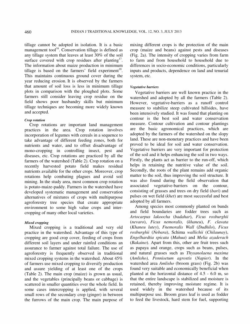
Mixed cropping
Mixed cropping is a traditional and very old
practice in the watershed. Advantage of this type of
cropping are good crop cover, feeding of crops from
different soil layers and under rainfed conditions an
assurance to farmer against total failure. The use of
agroforestry is frequently observed in traditional
mixed cropping systems in the watershed. About 45%
of farmers use mixed cropping to diversify production
and assure yielding of at least one of the crops
(Table 2). The main crop (maize) is grown as usual,
and the vegetables (principally beans or cabbage) is
scattered in smaller quantities over the whole field. In
some cases intercropping is applied, with several
small rows of the secondary crop (ginger) in between
the furrows of the main crop. The main purpose of
mixing different crops is the protection of the main
crop (maize and beans) against pests and diseases
(Fig. 2a). The intensity of cropping varies from farm
to farm and from household to household due to
differences in socio-economic conditions, particularly
inputs and products, dependence on land and tenurial
system, etc.
Vegetative barriers
Vegetative barriers are well known practice in the
watershed and adopted by all the farmers (Table 2).
However, vegetative-barriers as a runoff control
measure to stabilize steep cultivated hillsides, have
been intensively studied. It was found that planting on
contour is the best soil and water conservation
measure. Contour cultivation and contour plantings
are the basic agronomical practices, which are
adopted by the farmers of the watershed on the slopy
land. These are non-monetary practices and have been
proved to be ideal for soil and water conservation.
Vegetative barriers are very important for protection
of the soil and it helps enhancing the soil in two ways.
Firstly, the plants act as barrier to the run-off, which
helps in retaining the nutritive value of the soil.
Secondly, the roots of the plant remains add organic
matter to the soil, thus improving the soil structure. It
was also found during the field observation that
associated vegetative-barriers on the contour,
consisting of grasses and trees on dry field (bari) and
pulses on wet field (khet) are most successful and best
adopted by all farmers.
Among species most commonly planted on bunds
and field boundaries are fodder trees such as
Artocarpus lakoocha (badahar), Ficus roxburghii
(nevaro), Ficus nemoralis, (khaneu), F. clavata
(Khaneu lutey), Fnemoralis Wall (Dudhilo), Ficus
roxburghii (Nebara), Schima wallichii (Chilaunay),
Engelhardtia spicata (Mahua) and Melia azaderach
(Bakaino). Apart from this, other are fruit trees such
as papaya and orange, crops such as beans, pulses,
and natural grasses such as Thysanolaena maxima
(Amlisho), Pennisetum agrostis (Napier). In the
watershed area Amlisho (broom grass) (Fig. 2b) was
found very suitable and economically beneficial when
planted at the horizontal distance of 4.5 - 6.0 m, so
that the entire landscape is stabilized and moisture is
retained, thereby improving moisture regime. It is
used widely in the watershed because of its
multipurpose use. Broom grass leaf is used as fodder
to feed the livestock, hard stem for fuel, supporting
MISHRA & RAI: SOIL AND WATER CONSERVATION PRACTICES IN SIKKIM HIMALAYA
461
the vegetables in mixed cropping, and most important
its flower part, is used for making brooms which
fetches good price in the market. A good plant of
Amlisho produces approximately 5 kg of flower per
year and the market prices is Rs.30/- kg. This way a
plant is generating Rs 150/- to the farmers. It was
found in the group discussion with the farmers that to
cover one hectare of bunds and other suitable places
where Amlisho can play a vital role in soil and water
conservation. Clone and cutting method is used for
planting the bushes.
Agroforestry
The multi-functionality of the agroforestry systems
has been realized in the watershed over the last many
decades. Large cardamom based agroforestry system
is observed to accelerate the nutrient cycling,
increases the soil fertility and productivity, reduces
soil erosion, conserves biodiversity, and also
conserves water and soil. Large-Cardamom based Agroforestry system
Traditional cultivation of the large cardamom
(Amomum subulatum) in Sikkim is one example of
harnessing the local mountain niche (Fig. 3). Large
cardamom, a native plant of Sikkim, is a perennial
low-volume, high value, non-perishable cash crop
grown beneath the forest cover on marginal and
barren lands and can be grown between 600-2000 m
asl. It helps watershed in two ways: (i) by converting
abundant marginal and barren lands in more
productive lands and harnessing local niche, and
(ii) by maintaining and improving the ecosystem and
the environment of the region through promoting soil
conservation and soil fertility19
. The standing biomass
in the cardamom system is about 2.5 times higher
than in the maize-potato system, thereby providing
more biomass resources for farm family utilization.
The agronomic yield is very low in the cardamom
system, as much as 21 times less than in the maize-
potato system, indicating that cardamom are a low-
volume, high value cash crop. Soil fertility levels
influence plant productivity considerably. Therefore,
soil health is critical, especially in the mountains
where erosion problems are quite conspicuous. The
soil nutrient levels, especially organic carbon and
total nitrogen, in the cardamom agroforestry system
are comparatively higher than in the maize-potato
dominated system19
.
The large cardamom is cultivated either under
mixed tree species or under Alnus nepalensis cover.
The agronomic yield of the large cardamom is about
2.2 times higher beneath the Alnus tree than beneath
mixed tree species. According to the data,
65.34 kg/N/ha/yr was fixed in the cardamom
agroforestry system19
. Nitrogen and phosphorus
Fig. 2—(a) Mixed cropping: maize with ginger; (b) Broom grass:
as a vegetative barrier in agriculture field
Fig 3—Large-cardamom: an age old cash crop based agroforestry
system
INDIAN J TRADITIONAL KNOWLEDGE, VOL. 12, NO. 3, JULY 2013
462
concentrations of different tissues of N2-fixing Alnus
are higher than those of mixed tree species20
.
Mandarin Orange based Agroforestry system
Mandarin orange is a major tree crop while
intercropping of maize, pulses, ginger, buckwheat,
fingermillet, pulses, oilseeds, taro and yam are also
practiced. Mandarin orange and ginger are potential
cash crops after large cardamom. Albizzia is widely
grown with other agroforestry trees in mandarin-
based farming. Mandarin orange is a high value,
comparatively less labour intensive cash crop.
Diversity of crops and other associate tree species are
maintained in the system for other subsistence
requirements and benefits. The on-farm agroforestry
species such as Erythrina indica, Ficus spp. Alnus
nepalensis, Albizia spp., Artocarpus lacoocha,
Thysanolema maxima, Dendrocalamus spp. etc. are
agro-ecologically adapted and socially accepted
keystone species for their role in conserving and
enhancing biodiversity in the mountain watersheds.
Alnus and Albizzia have been a boon to the region for
their role in nitrogen fixation, ecological adaptability,
natural regeneration and restoration of degraded
landslide areas, and accelerated nutrient cycling in the
cultivated systems. Soil fertility management
Besides adoption of structural and biological
measures, farmers of the watershed apply different
types of organic, green manures and crop residue and
weed burning practices to improve land productivity.
Farm Yard Manure
Farm Yard Manure (FYM), comprising mainly
manure and livestock bedding, is the major source of
fertilizer in the area. Livestock beds, consisting of
waste fodder, tree leaves, and crop weeds, and manure
are cleared twice a day to keep the goth clean. These
materials are normally dumped in front of goth in a
3-4 foot-deep pit and remain exposed to the sun, rain
and wind for several weeks until their transfer to the
field. The amount of FYM applied to all types of land
is significantly high in the low and mid ecological
zone. Overall, farmlands in the watershed receive
FYM at the rate of 12400 kg/ha/yr. In all ecological
zones; priority is given to gharbari followed by bari
for application of FYM. Though it is a major source
of fertilizer, the supply of FYM is steadily declining
in the watershed as farmers have reduced their
livestock herd size to cope with shortage of labour
and gradually shrinking grazing-lands and
landholdings7.
Green manures
Applying green manure species, namely Adhatoda
vasica, Euphorbia roylena, Artemissia vulgaris spp,
etc. to vegetable and paddy seedbeds has been a
traditional practice of small percentage of farm
households in the area (Table 2). Mostly found in the
wild, these plant species contain more than double
amounts of NPK compared to FYM21, 22
. Some of
these species are also considered useful for
controlling weeds and pests. Despites their awareness
of the usefulness of green manure, farmers has not
been able to apply it intensively because of the
scarcity caused by lack of conservation and
promotional efforts. In response to the dwindling
availability of green manure, farmers are using leaves
of Sachima wallichi and Castanopsis spp. Especially
for paddy cultivation. These species, according to
farmers, have low nutrient content and helps prevent
soil from becoming acidic. In some instances weeds
grown in the fields are also being utilized as green
manure, specifically for millet.
Crop residue and Weed burning
Burning crop residue and weeds is a traditional
method of fertilizing particularly in bari land. During
the dry summer season, farmers collect maize and
millet stubble, leftover paddy straw, dried weeds, and
woody plants grown in bari terrace. The collected
biomass is burned when sign of rainfall appears, so as
to allow the ash to get mixed well with the soil after
the rain as well as to control the fire from spreading
into other farm plots. Farmers spread the ash all over
the farm plot to enhance soil fertility and to control
some pests. Similar practices are being reported in
other parts of the Hindu-Kush Himalayan region7.
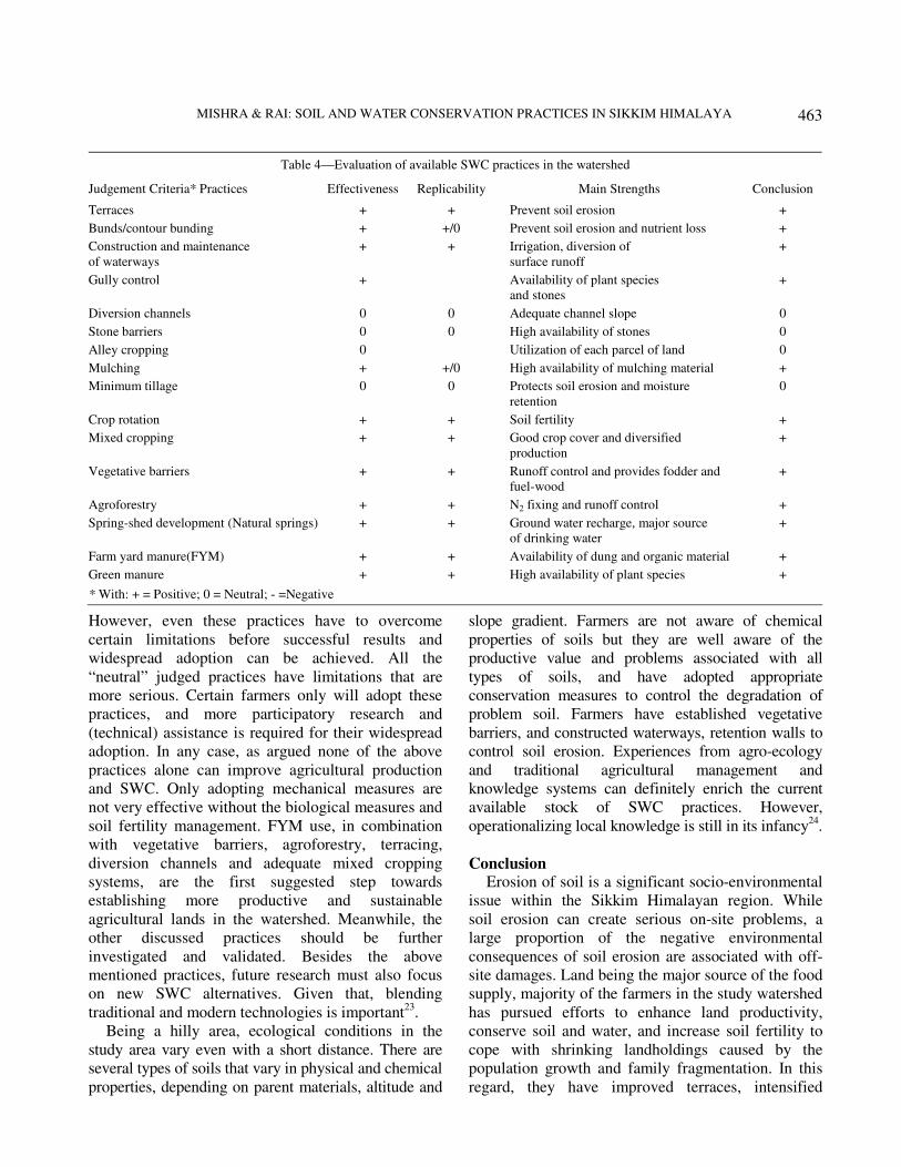
Evaluation of indigenous practices
Indigenous soil and water conservation practices
are widely used by the farmers of the watershed.
However, the validation study during the field visit
and research findings revealed that most of them are
technically effective and at the same time easily
replicated by farmers. Table 4 illustrates an overview
of all SWC practices that were used by the farmers.
The present practices were judged by the following
criterion: (i) effectiveness, (ii) replicability, and (iii)
ranking. Table 4 also reveals that most of the SWC
practices receive an overall positive conclusion.
MISHRA & RAI: SOIL AND WATER CONSERVATION PRACTICES IN SIKKIM HIMALAYA
463
However, even these practices have to overcome
certain limitations before successful results and
widespread adoption can be achieved. All the
“neutral” judged practices have limitations that are
more serious. Certain farmers only will adopt these
practices, and more participatory research and
(technical) assistance is required for their widespread
adoption. In any case, as argued none of the above
practices alone can improve agricultural production
and SWC. Only adopting mechanical measures are
not very effective without the biological measures and
soil fertility management. FYM use, in combination
with vegetative barriers, agroforestry, terracing,
diversion channels and adequate mixed cropping
systems, are the first suggested step towards
establishing more productive and sustainable
agricultural lands in the watershed. Meanwhile, the
other discussed practices should be further
investigated and validated. Besides the above
mentioned practices, future research must also focus
on new SWC alternatives. Given that, blending
traditional and modern technologies is important23
.
Being a hilly area, ecological conditions in the
study area vary even with a short distance. There are
several types of soils that vary in physical and chemical
properties, depending on parent materials, altitude and
slope gradient. Farmers are not aware of chemical
properties of soils but they are well aware of the
productive value and problems associated with all
types of soils, and have adopted appropriate
conservation measures to control the degradation of
problem soil. Farmers have established vegetative
barriers, and constructed waterways, retention walls to
control soil erosion. Experiences from agro-ecology
and traditional agricultural management and
knowledge systems can definitely enrich the current
available stock of SWC practices. However,
operationalizing local knowledge is still in its infancy24
.
Conclusion Erosion of soil is a significant socio-environmental
issue within the Sikkim Himalayan region. While
soil erosion can create serious on-site problems, a
large proportion of the negative environmental
consequences of soil erosion are associated with off-
site damages. Land being the major source of the food
supply, majority of the farmers in the study watershed
has pursued efforts to enhance land productivity,
conserve soil and water, and increase soil fertility to
cope with shrinking landholdings caused by the
population growth and family fragmentation. In this
regard, they have improved terraces, intensified
Table 4—Evaluation of available SWC practices in the watershed
Judgement Criteria* Practices Effectiveness Replicability Main Strengths Conclusion
Terraces + + Prevent soil erosion +
Bunds/contour bunding + +/0 Prevent soil erosion and nutrient loss +
Construction and maintenance
of waterways
+ + Irrigation, diversion of
surface runoff
+
Gully control + Availability of plant species
and stones
+
Diversion channels 0 0 Adequate channel slope 0
Stone barriers 0 0 High availability of stones 0
Alley cropping 0 Utilization of each parcel of land 0
Mulching + +/0 High availability of mulching material +
Minimum tillage 0 0 Protects soil erosion and moisture
retention
0
Crop rotation + + Soil fertility +
Mixed cropping + + Good crop cover and diversified
production
+
Vegetative barriers + + Runoff control and provides fodder and
fuel-wood
+
Agroforestry + + N2 fixing and runoff control +
Spring-shed development (Natural springs) + + Ground water recharge, major source
of drinking water
+
Farm yard manure(FYM) + + Availability of dung and organic material +
Green manure + + High availability of plant species +
* With: + = Positive; 0 = Neutral; - =Negative
INDIAN J TRADITIONAL KNOWLEDGE, VOL. 12, NO. 3, JULY 2013
464
agroforestry practices and participated in gully
control, and waterway construction activities. They
also practices alley cropping and mulching to improve
land productivity. The study watershed is very strong
in traditional soil and water conservation practices.
Most of the indigenous practices are readily available
and can be promoted without major restrictions, viz.
terrace, contour bunding, agroforestry, vegetative
barriers, diversion channels, stone barriers, mixed
cropping, crop rotation and FYM/green manure. All
these practices are based on indigenous knowledge.
The findings of this study justify that farmers devise
alternative technologies for increasing land
productivity, as they are exposed to the risk of food
scarcity due to shrinking per capita land holdings. The
significance findings of this study have important
policy implications for sustainable land management
in the area. Any future land management initiative
should aim at enabling watershed settlers to adopt
practices conducive to increase income as well as to
enhance land conservation.
Acknowledgement Authors are thankful to the Head, Department of
Geography, Delhi School of Economics, University of
Delhi for providing facilities. Authors are also
thankful to the farmers of Temi-Tarku, Damthang,
Deo, and Raigaon villages of Papung-Ben Khola
watershed for their support and information during
field survey.
References 1 Messerli B & Ives JD, Mountains of the world: a global
priority, (Parthenon Publishing Group, New York), 1997.
2 Rai SC & Sharma E, Comparative assessment of runoff
characteristics under different land-use pattern within a
Himalayan watershed, Hydrological Processes, 12 (1998)
2235-2248.
3 Rai SC & Sharma E, Hydrology and nutrient flux in an
agrarian watershed of the Sikkim Himalaya, J Soil Water
Conserv, 53 (1998) 125-132.
4 Napier TL, Use of soil and water protection practices among
farmers in the north central region of the United States, J Am
Water Resour Asso, 36 (2000) 723-735.
5 Bali JS, Integrated watershed management: a national
perspective, In: Proceeding of International Symposium on
Water Erosion, Sedimentation and Resource Conservation,
9-13th October, 1990, (CSWCRTI, Dehradun), 1990.
6 Narayan Druva VV & Ram Babu, Estimation of soil erosion
in India, J Irrigation Drainage Eng, 109 (1983) 419-434.
7 Paudel GS & Thapa GB, Changing farmers’ land
management practices in the hills of Nepal, Envir Manage,
28 (2001) 789-803.
8 Johnson K, Olson EA & Manandhar S, Environmental
knowledge and response to natural hazards in mountainous
Nepal, Mountain Res Dev, 2 (1982) 157-188.
9 Carson B, The land, the farmers and future: a soil fertility
management strategy for Nepal, ICIMOD Occasional
Paper No. 21, (Kathmandu, Nepal), 1992.
10 Basnyet SK, Micro-level environmental management:
observations on public and private responses in Kakani
Panchayat, ICIMOD Occasional Paper No. 12, (Kathmandu,
Nepal), 1989.
11 Ojha ER, Ecosystem dynamic analysis: the case of the hills
in far western Nepal, (AIT Dissertation No. H.S. 95-3,
Bangkok, Thailand), 1995.
12 Morgan RPC, Soil erosion and conservation, (Longman
Group Limited, Malaysia), 1995.
13 Ya T, Soil conservation and soil fertility improvement through
contour hedgerow, ICIMOD, Newsletter, 32(1998) 8-11.
14 Denholm J, Agroforestry in mountain areas of the Hindu-
Kush Himalayan region, ICIMOD Occasional Paper No. 17,
(Kathmandu, Nepal), 1991.
15 Singh G, Dayal R & Bhola SN, Soil and water loss studies
under different vegetative covers on 0.5 and 1.0% slope at
Kota, J Soil Water Conserv, 15(1967) 17-23.
16 Lal R, Conservation tillage for sustainable agriculture:
tropics vs temperate environment, Adv Agron, 42(1989)
186-197.
17 Tippett J P & Dodd RC, Cost effectiveness of agricultural
BMPs for nutrient reduction in the Tar-Pamlico basin. Report
to North Carolina Department of Environment, Health
and Natural Resources, Division of Environmental-
Management.http://www.bae.ncsu.edu/programs/extension/w
qg/issues/72.html. (Accessed on 15th March, 2010) 1995.
18 Atreya K, Sharma S, Bajracharya RM & Rajbhandari NP,
Application of Reduced Tillage in hills of Central Nepal, Soil
Tillage Res, 88 (2007) 16-29.
19 Sharma HR & Sharma E, Mountain agricultural
transformation processes and sustainability in the Sikkim
Himalaya, India. Discussion Paper, Series No. MFS97/2,
(ICIMOD, Kathmandu, Nepal), 1997.
20 Sharma R, Symbiotic nitrogen fixation and biological
maintenance of soil fertility in the Sikkim Himalaya, (Ph.D.
Thesis, H.N.B. Garhwal University, UP, India), 1995.
21 Subedi KD & Gurung G, Soil fertility trusts towards
sustainable agriculture: experiences of Lumle agriculture
research center, Lumle, (Technical Paper No. 4/91, Pokhra,
Nepal), 1991.
22 Joshi D, Indigenous technical knowledge in Nepal, In: Issues
on sustainable land management, edited by Lesile R,
(International Board for Soil Research and Management
(IBSRAM) Bangkok, Thailand), 1997.
23 Ellis-Jones J & Mason T, Livelihood strategies and assets of
small farmers in the evaluation of soil and water
management practices in the temperate inter-Andean valleys
of Bolivia, Mountain Res Dev, 19(1999) 221-234.
24 Winklerprins AMG, & Barrera-Bassols N, Latin American
ethno-pedology: a vision of its past, present and future, Agric
Hum Val, 21(2004) 139-156