use of a mobile bim application integrated with asset ...rical.ce.gatech.edu/papers/criocm2016_park...
TRANSCRIPT
Park, J. and Cho, Y. (2016). "Use of Mobile BIM Application integrated with Asset Tracking and Cloud
Computing Technologies." Invited Speech, CRIOCM 21st International Conference on "Advancement of
Construction Management and Real Estate" Hong Kong, Dec. 14-17.
Use of a Mobile BIM Application Integrated with Asset
Tracking Technology over a Cloud
Park, J.1 and Cho, Y.K.2*
Abstract: Over the last decade, BIM and tracking have been explored by many researchers.
Despite the extensive efforts in these domains, they have been mostly individually studied, and
limited effort was made to fully integrate them into a single system. This study proposes a new
development of a virtual mobile BIM platform for an on-site application by integrating the three
systems: Building information modeling (BIM), Bluetooth Low Energy (BLE), and inertial
measurement units (IMU). The proposed system is created by 1) developing a low-cost tracking
system using BLE and IMU, 2) developing a mobile BIM platform, and 3) integrating the
developed components over a cloud. The tracking system is comprised of BLE-sensors, IMU
sensors, and map knowledge. The mobile BIM platform is developed through data extraction from
BIM and then integration into the tracking system. The study conducts a field experiment to
demonstrate the capability of the system with respect to the real-time tracking information, the
corresponding virtual BIM view, and communication. The test results show that the integration of
the system is successful between the tracking system and the mobile BIM system, and that a new
on-site communication tool using BIM and tracking is successfully implemented. In conclusion,
the study advances the use of BIM and tracking with system integration that can improve the
overall project management and coordination.
Keywords: Building Information Modeling; BIM; Bluetooth Low Energy; BLE; Cloud; IMU;
Tracking;
1* Park, J.
School of Civil and Environmental Engineering, Georgia Institute of Technology, ,790 Atlantic Dr. N.W., Atlanta,
GA 30332-0355, United States 2 Cho, Y.K.
Corresponding author, School of Civil and Environmental Engineering, Georgia Institute of Technology, ,790
Atlantic Dr. N.W., Atlanta, GA 30332-0355, United States
E-mail: [email protected]
Park, J. and Cho, Y. (2016). "Use of Mobile BIM Application integrated with Asset Tracking and Cloud
Computing Technologies." Invited Speech, CRIOCM 21st International Conference on "Advancement of
Construction Management and Real Estate" Hong Kong, Dec. 14-17.
1 Introduction
With the advancement of mobile communication technology, construction management has
become busier, complex and dynamic. These trends demand that construction professionals be
more effective and organized to handle the demands of modern operations. Over the last decade,
Building Information Modeling (BIM) has become an essential tool that provides an intelligent
platform to efficiently plan, design, construct, simulate, and manage buildings and relevant
information in a digital form [1]. This digital form of data allows sharing and managing of project
plans and information among stakeholders much more effectively than the conventional
paper-based methods. A rapid adoption of BIM followed this technological advancement by the
industry. The evolution of BIM in the AEC industry brought a paradigm shift from the traditional
project delivery process.
Despite the advancement, the construction sector still struggles due to the lack of effective
construction management methods in various aspects of construction operations: safety
management [2,3], assess control [4], quality inspection and control [5,6], and progress of as-built
environment [7,8]. For instance, project inspectors/managers spend a considerable amount of time
on-site for 1) looking up information, such as plans and specifications, 2) manually taking notes in
the field and logging in such information in the office. Existing methods of tracking and managing
defect detection and material inspection still rely on a labor-intensive, unreliable manual recording
on paper-based documents [5]. Furthermore, other common on-site problems include time and
space discrepancies between a construction-site and a remote office, insufficient number of on-site
managers, and inefficient communication among project stakeholders [6,9]. Cho et al. (2015)
proposed a cloud-based energy management system and showed its efficacy as a decision support
tool. In construction, use of such cloud-based communication can help to better address the
mentioned on-site issues, but such a tool is missing in state of the art construction management
tools. In addition, the digital data representing a building model often fails to provide
construction-specific information and therefore requires extra effort in analyzing the model and
then developing detailed project-specific construction plans [11].
Recent advancements in mobile technology enabled commercial development of mobile BIM.
These are, however, still in the beginning stage of development and use in construction. Our
recent in-person interviews with construction companies indicate many issues with such
technologies to be practically used on-site. The users are required to be familiar with them for
operation. This, in turn, necessitates extra costs in training and educating crews on regular basis.
In addition, due to the lack of location awareness within a current mobile BIM system, the users
need to manually navigate through the virtual BIM environment to find their locations. Also, due
to the same reason, the system does not have the interactive ability to visualize near-by context
information and provide object data relevant to the users.
As discussed above, the benefits of BIM are evident for use in office, but when it comes to
construction in field, there exist challenges and issues that limit the effective use of BIM in certain
aspects. Thus, this research presents a new approach to provide a more effective tool for on-site
use. The approach combines a tracking system with a mobile BIM. The research uses sensing and
mobile technologies to explore the integrated system. This system has potential to realize Internet
of Things (IoT) through the use of a cloud, which can offer an increased connectivity to the world
Park, J. and Cho, Y. (2016). "Use of Mobile BIM Application integrated with Asset Tracking and Cloud
Computing Technologies." Invited Speech, CRIOCM 21st International Conference on "Advancement of
Construction Management and Real Estate" Hong Kong, Dec. 14-17.
and a transformative, revolutionary impact on the construction domain. In the remaining sections,
this paper will introduce an initiating effort by realizing a Bluetooth Low Energy (BLE) indoor
tracking system on a mobile BIM environment that provides a cloud communication tool.
2 Literature Review
Positioning technology has gained rapid attention and has in fact been used in our lives for
decades. With the introduction of Global Positioning System (GPS) technology, it has already
been rooted in many forms of outdoor applications including navigating, tracking and monitoring.
Available position information can be extended to location-based applications. Over the last
decade, many researchers have investigated various topics of the indoor positioning field with
different sensing protocols, including UWB [12,13], RFID [14,15], and Wi-Fi [16], with different
tracking algorithms including fingerprinting, lateration, and proximity. Despite these efforts, there
still exist many technical and practical challenges that prevent widespread use of indoor tracking
applications [17]. To overcome the challenges, this study uses a relatively new technology, BLE,
that offers special features over other sensing technologies, including low cost, small form factor,
and low energy researchers [18–20].
In another aspect of effort to overcome the drawbacks, a few researchers have explored BIM
in the development of a tracking/monitoring system. Shen and Marks (2016) introduced a
framework to visualize near-miss data, manually collected by construction-site personnel, in a
BIM platform. Fang et al. (2016) proposed an integrated BIM-RFID tracking system for
construction management applications. This study, however, presents several drawbacks as for
real-time application yet: 1) BIM was used only for visualization purposes, 2) the used approach,
proximity cell-based localization, was unable to perform continuous tracking of a target, and 3)
the system required complex installation of sensors with wired power sources. Li et al. (2014)
conducted a study to develop a positioning algorithm that takes into account the signal attenuation
from walls. This study made an initiating effort to utilize a BIM model to iteratively recognize
nearby walls and consider a certain signal loss from each of detected walls nearby the target. To
fully consider the signal attenuation occurring in Radio Signal Strength Indication (RSSI)-based
technology, there exist more factors, such as ceiling, floor, human, and existing radio signals that
can negatively impact the signal quality. In addition, although BIM was integrated as part of the
system, the role of BIM was limited to iteratively detecting walls, and the walls were assumed to
offer a constant factor of signal reduction. A more recent study conducted by Park et al. (2016)
presented an effective use of BIM in conjunction with tracking for a safety application. Their
developed system extracted BIM’s object data and used it to serve as geometric boundaries to
assist tracking and to visualize the tracking results with respect to the safety hazard conditions
used in their study. Although these efforts are found within the BIM and tracking domain, limited
research work is done that utilizes a 3D BIM model to create a virtual environment presenting a
construction site and that utilizes building elements as a base of communication tool for
construction applications.
3 Objective
Park, J. and Cho, Y. (2016). "Use of Mobile BIM Application integrated with Asset Tracking and Cloud
Computing Technologies." Invited Speech, CRIOCM 21st International Conference on "Advancement of
Construction Management and Real Estate" Hong Kong, Dec. 14-17.
The objective of this study was to develop a cloud-based on-site construction management tool
that utilizes BIM and tracking technologies. This system should provide 1) location information of
the user within a mobile BIM environment; 2) rich project information from BIM; and 3) a
communication platform to store and share information collected at the site with other associated
stakeholders.
4 Methodology
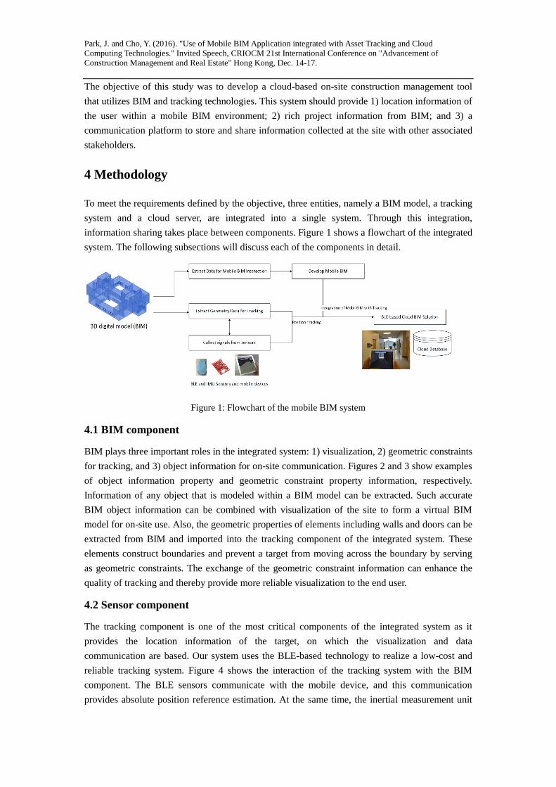
To meet the requirements defined by the objective, three entities, namely a BIM model, a tracking
system and a cloud server, are integrated into a single system. Through this integration,
information sharing takes place between components. Figure 1 shows a flowchart of the integrated
system. The following subsections will discuss each of the components in detail.
Figure 1: Flowchart of the mobile BIM system
4.1 BIM component
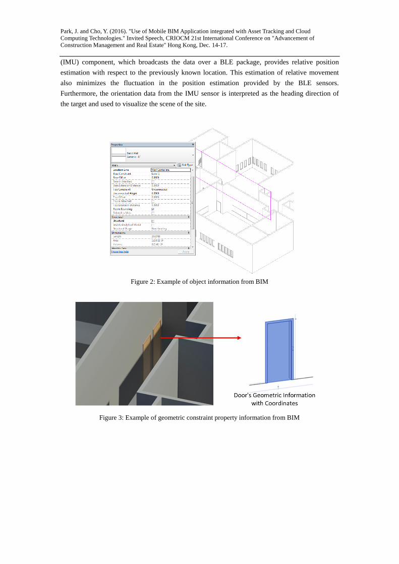
BIM plays three important roles in the integrated system: 1) visualization, 2) geometric constraints
for tracking, and 3) object information for on-site communication. Figures 2 and 3 show examples
of object information property and geometric constraint property information, respectively.
Information of any object that is modeled within a BIM model can be extracted. Such accurate
BIM object information can be combined with visualization of the site to form a virtual BIM
model for on-site use. Also, the geometric properties of elements including walls and doors can be
extracted from BIM and imported into the tracking component of the integrated system. These
elements construct boundaries and prevent a target from moving across the boundary by serving
as geometric constraints. The exchange of the geometric constraint information can enhance the
quality of tracking and thereby provide more reliable visualization to the end user.
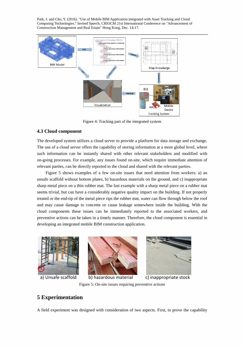
4.2 Sensor component
The tracking component is one of the most critical components of the integrated system as it
provides the location information of the target, on which the visualization and data
communication are based. Our system uses the BLE-based technology to realize a low-cost and
reliable tracking system. Figure 4 shows the interaction of the tracking system with the BIM
component. The BLE sensors communicate with the mobile device, and this communication
provides absolute position reference estimation. At the same time, the inertial measurement unit
Park, J. and Cho, Y. (2016). "Use of Mobile BIM Application integrated with Asset Tracking and Cloud
Computing Technologies." Invited Speech, CRIOCM 21st International Conference on "Advancement of
Construction Management and Real Estate" Hong Kong, Dec. 14-17.
(IMU) component, which broadcasts the data over a BLE package, provides relative position
estimation with respect to the previously known location. This estimation of relative movement
also minimizes the fluctuation in the position estimation provided by the BLE sensors.
Furthermore, the orientation data from the IMU sensor is interpreted as the heading direction of
the target and used to visualize the scene of the site.
Figure 2: Example of object information from BIM
Figure 3: Example of geometric constraint property information from BIM
Park, J. and Cho, Y. (2016). "Use of Mobile BIM Application integrated with Asset Tracking and Cloud
Computing Technologies." Invited Speech, CRIOCM 21st International Conference on "Advancement of
Construction Management and Real Estate" Hong Kong, Dec. 14-17.
Figure 4: Tracking part of the integrated system
4.3 Cloud component
The developed system utilizes a cloud server to provide a platform for data storage and exchange.
The use of a cloud server offers the capability of storing information at a more global level, where
such information can be instantly shared with other relevant stakeholders and modified with
on-going processes. For example, any issues found on-site, which require immediate attention of
relevant parties, can be directly reported to the cloud and shared with the relevant parties.
Figure 5 shows examples of a few on-site issues that need attention from workers: a) an
unsafe scaffold without bottom plates, b) hazardous materials on the ground, and c) inappropriate
sharp metal piece on a thin rubber mat. The last example with a sharp metal piece on a rubber mat
seems trivial, but can have a considerably negative quality impact on the building. If not properly
treated or the end-tip of the metal piece rips the rubber mat, water can flow through below the roof
and may cause damage to concrete or cause leakage somewhere inside the building. With the
cloud components these issues can be immediately reported to the associated workers, and
preventive actions can be taken in a timely manner. Therefore, the cloud component is essential in
developing an integrated mobile BIM construction application.
a) Unsafe scaffold b) hazardous material c) inappropriate stock
Figure 5: On-site issues requiring preventive actions
5 Experimentation
A field experiment was designed with consideration of two aspects. First, to prove the capability
Park, J. and Cho, Y. (2016). "Use of Mobile BIM Application integrated with Asset Tracking and Cloud
Computing Technologies." Invited Speech, CRIOCM 21st International Conference on "Advancement of
Construction Management and Real Estate" Hong Kong, Dec. 14-17.
of the tracking component of the integrated system, the test was designed with different spaces
and complex movements. Second, BIM information including the model view as well as property
information was verified though the provided mobile BIM user interface which communicates
over a cloud.
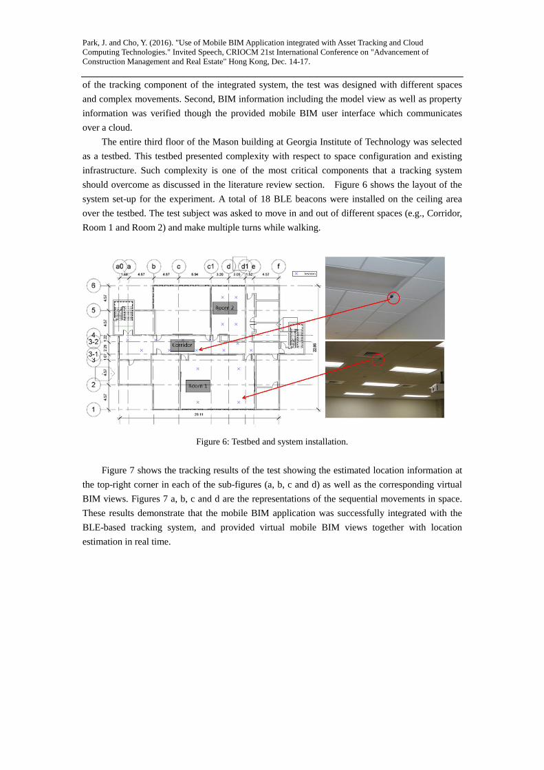
The entire third floor of the Mason building at Georgia Institute of Technology was selected
as a testbed. This testbed presented complexity with respect to space configuration and existing
infrastructure. Such complexity is one of the most critical components that a tracking system
should overcome as discussed in the literature review section. Figure 6 shows the layout of the
system set-up for the experiment. A total of 18 BLE beacons were installed on the ceiling area
over the testbed. The test subject was asked to move in and out of different spaces (e.g., Corridor,
Room 1 and Room 2) and make multiple turns while walking.
Figure 6: Testbed and system installation.
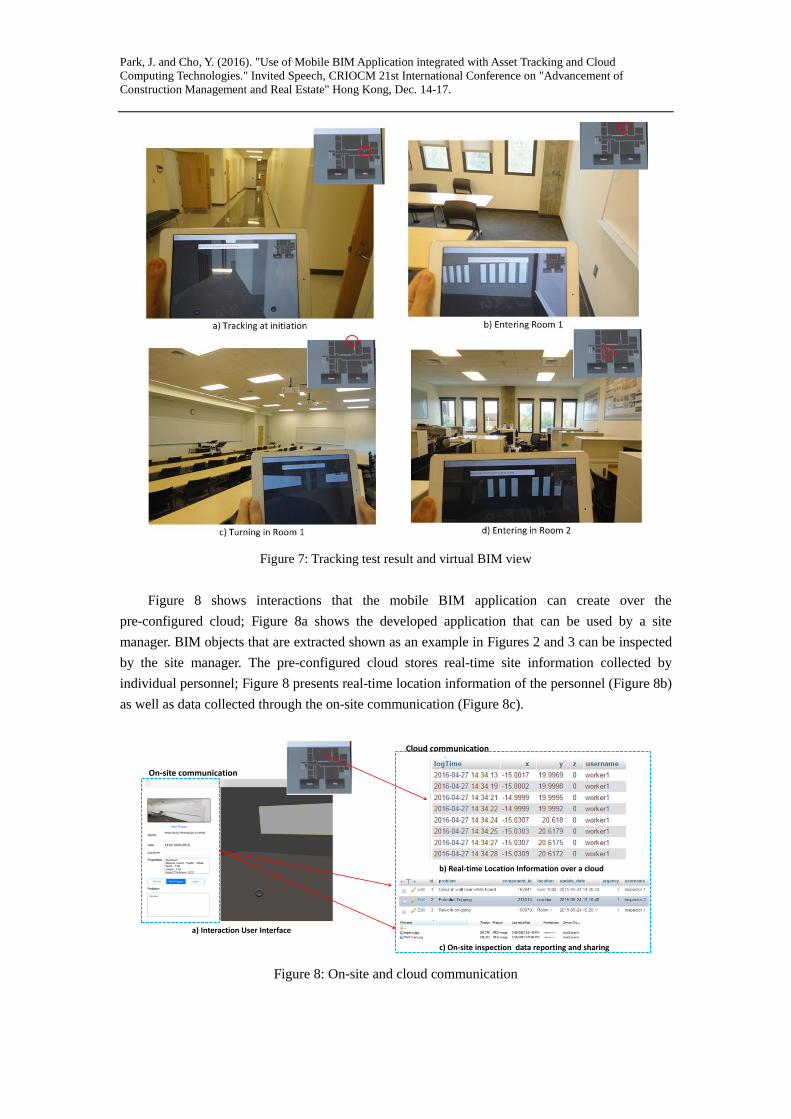
Figure 7 shows the tracking results of the test showing the estimated location information at
the top-right corner in each of the sub-figures (a, b, c and d) as well as the corresponding virtual
BIM views. Figures 7 a, b, c and d are the representations of the sequential movements in space.
These results demonstrate that the mobile BIM application was successfully integrated with the
BLE-based tracking system, and provided virtual mobile BIM views together with location
estimation in real time.
Park, J. and Cho, Y. (2016). "Use of Mobile BIM Application integrated with Asset Tracking and Cloud
Computing Technologies." Invited Speech, CRIOCM 21st International Conference on "Advancement of
Construction Management and Real Estate" Hong Kong, Dec. 14-17.
Figure 7: Tracking test result and virtual BIM view
Figure 8 shows interactions that the mobile BIM application can create over the
pre-configured cloud; Figure 8a shows the developed application that can be used by a site
manager. BIM objects that are extracted shown as an example in Figures 2 and 3 can be inspected
by the site manager. The pre-configured cloud stores real-time site information collected by
individual personnel; Figure 8 presents real-time location information of the personnel (Figure 8b)
as well as data collected through the on-site communication (Figure 8c).
a) Interaction User Interface
b) Real-time Location Information over a cloud
c) On-site inspection data reporting and sharing
Cloud communication
On-site communication
Figure 8: On-site and cloud communication
Park, J. and Cho, Y. (2016). "Use of Mobile BIM Application integrated with Asset Tracking and Cloud
Computing Technologies." Invited Speech, CRIOCM 21st International Conference on "Advancement of
Construction Management and Real Estate" Hong Kong, Dec. 14-17.
5 Conclusion
Over the last decade, BIM and tracking have been explored by many researchers. Despite the
extensive efforts in these domains, they have been mostly individually studied, and limited efforts
were made to fully integrate them into a single system. This study proposed a new development of
a virtual mobile BIM platform for an on-site application by integrating the two systems. The
proposed system was created by 1) developing a low-cost BLE-based tracking system, 2)
developing a mobile BIM platform, and 3) integrating the developed components over a cloud.
The tracking system was comprised of BLE-sensors, IMU sensors, and map knowledge. The
mobile BIM platform was developed through data extraction from BIM and then integration into
the tracking system. A field experiment was conducted to demonstrate the capability of the system
with respect to the real-time tracking information, the corresponding virtual BIM view, and
communication. The test results showed that the successful integration of the system was made
between the tracking system and the mobile BIM system, and that a new on-site communication
tool using BIM and tracking was successfully implemented. In conclusion, the study advanced the
use of BIM and tracking with system integration that can improve the overall project management
and coordination.
Acknowledgement
This material is based upon work supported by the National Science Foundation (IIP-1513589).
Any opinions, findings, and conclusions or recommendations expressed on this material are those
of the authors and do not necessarily reflect the views of the National Science Foundation.
References
[1] C. Eastman, P. Teicholz, R. Sacks, K. Liston, BIM Handbook: A Guide to Building Information
Modeling for Owners, Managers, Designers, Engineers and Contractors, 2011.
doi:10.1002/9780470261309.
[2] A. Carbonari, A. Giretti, B. Naticchia, A proactive system for real-time safety management in
construction sites, Autom. Constr. 20 (2011) 686–698. doi:10.1016/j.autcon.2011.04.019.
[3] J. Park, E. Marks, Y.K. Cho, W. Suryanto, Performance Test of Wireless Technologies for Personnel
and Equipment Proximity Sensing in Work Zones, J. Constr. Eng. Manag. 142 (2015) 4015049.
doi:10.1061/(ASCE)CO.1943-7862.0001031.
[4] Fiatech, RFID for Access Control in Construction Sites, 2012.
doi:10.1016/S0022-3913(12)00047-9.
[5] L.C. Wang, Enhancing construction quality inspection and management using RFID technology,
Autom. Constr. 17 (2008) 467–479. doi:10.1016/j.autcon.2007.08.005.
[6] Y.S. Kim, S.W. Oh, Y.K. Cho, J.W. Seo, A PDA and wireless web-integrated system for quality
inspection and defect management of apartment housing projects, Autom. Constr. 17 (2008)
163–179. doi:10.1016/j.autcon.2007.03.006.
[7] C. Wang, Y.K. Cho, J. Park, Performance Tests for Automatic 3D Geometric Data Registration
Technique for Progressive As-Built Construction Site Modeling, in: Comput. Civ. Build. Eng.,

Park, J. and Cho, Y. (2016). "Use of Mobile BIM Application integrated with Asset Tracking and Cloud
Computing Technologies." Invited Speech, CRIOCM 21st International Conference on "Advancement of
Construction Management and Real Estate" Hong Kong, Dec. 14-17.
ASCE, 2014: pp. 1053–1061.
[8] S.W. Leung, S. Mak, B.L.P. Lee, Using a real-time integrated communication system to monitor the
progress and quality of construction works, Autom. Constr. 17 (2008) 749–757.
doi:10.1016/j.autcon.2008.02.003.
[9] K. Kimoto, K. Endo, S. Iwashita, M. Fujiwara, The application of PDA as mobile computing
system on construction management, Autom. Constr. 14 (2005) 500–511.
doi:10.1016/j.autcon.2004.09.003.
[10] Y.K. Cho, H. Li, J. Park, K. Zheng, A Framework for Cloud-based Energy Evaluation and
Management for Sustainable Decision Support in the Built Environments, in: Procedia Eng., 2015:
pp. 442–448. doi:10.1016/j.proeng.2015.08.445.
[11] K. Kim, Y.K. Cho, Construction-Specific Spatial Information Reasoning in Building Information
Models, J. Adv. Eng. Informatics. (2015). doi:10.1016/j.aei.2015.08.004.
[12] J. Park, Y.K. Cho, D. Martinez, A BIM and UWB integrated Mobile Robot Navigation System for
Indoor Position Tracking Applications, J. Constr. Eng. Proj. Manag. 6 (2016) 30–39.
doi:10.6106/JCEPM.2016.6.2.030.
[13] Y.K. Cho, J.H. Youn, D. Martinez, Error modeling for an untethered ultra-wideband system for
construction indoor asset tracking, Autom. Constr. 19 (2010) 43–54.
doi:10.1016/j.autcon.2009.08.001.
[14] Y. Fang, Y.K. Cho, S. Zhang, E. Perez, Case Study of BIM and Cloud–Enabled Real-Time RFID
Indoor Localization for Construction Management Applications, J. Constr. Eng. Manag. 142 (2016).
doi:10.1061/(ASCE)CO.1943-7862.0001125.
[15] N. Li, B. Becerik-Gerber, L. Soibelman, B. Krishnamachari, Comparative assessment of an indoor
localization framework for building emergency response, Autom. Constr. 57 (2015) 42–54.
doi:10.1016/j.autcon.2015.04.004.
[16] S. Woo, S. Jeong, E. Mok, L. Xia, C. Choi, M. Pyeon, et al., Application of WiFi-based indoor
positioning system for labor tracking at construction sites: A case study in Guangzhou MTR, Autom.
Constr. 20 (2011) 3–13. doi:10.1016/j.autcon.2010.07.009.
[17] S.M. Kodeboyina, K. Varghese, Low Cost Augmented Reality Framework for Construction
Applications, in: 33rd Int. Symp. Autom. Robot. Constr. (ISARC 2016) Low, 2016.
[18] C. Gomez, J. Oller, J. Paradells, Overview and Evaluation of Bluetooth Low Energy: An
Emerging Low-Power Wireless Technology, Sensors. 12 (2012) 11734–11753.
doi:10.3390/s120911734.
[19] F. Palumbo, P. Barsocchi, S. Chessa, J.C. Augusto, A stigmergic approach to indoor localization
using Bluetooth Low Energy beacons, Adv. Video Signal Based Surveill. (AVSS), 2015 12th IEEE
Int. Conf. (2015) 1–6. doi:10.1109/AVSS.2015.7301734.
[20] Y. Zhuang, J. Yang, Y. Li, L. Qi, N. El-Sheimy, Smartphone-based indoor localization with
bluetooth low energy beacons, Sensors (Switzerland). 16 (2016) 1–20. doi:10.3390/s16050596.
[21] X. Shen, E.D. Marks, Near-Miss Information Visualization Tool in BIM for Construction Safety, J.
Constr. Eng. Manag. 142 (2016) 1–12. doi:10.1061/(ASCE)CO.1943-7862.
[22] N. Li, B. Becerik-Gerber, L. Soibelman, Iterative Maximum Likelihood Estimation Algorithm:
Leveraging Building Information and Sensing Infrastructure for Localization during Emergencies, J.
Comput. Civ. Eng. 3 (2014) 4014094. doi:10.1061/(ASCE)CP.1943-5487.0000430.
[23] J. Park, K. Kim, Y.K. Cho, Framework of Automated Construction-Safety Monitoring Using

Park, J. and Cho, Y. (2016). "Use of Mobile BIM Application integrated with Asset Tracking and Cloud
Computing Technologies." Invited Speech, CRIOCM 21st International Conference on "Advancement of
Construction Management and Real Estate" Hong Kong, Dec. 14-17.
Cloud-Enabled BIM and BLE Mobile Tracking Sensors, J. Constr. Eng. Manag. (2016) 5016019.
doi:10.1061/(ASCE)CO.1943-7862.0001223.