u.s. fish & wildlife service izembek - united states fish ...€¦ · additional data and...
TRANSCRIPT

DES 12
U.S. Fish & Wildlife Service
Izembek National Wildlife Refuge Land Exchange/Road Corridor Final Environmental Impact Statement
Executive Summary

U.S. Fish and Wildlife Service Mission Statement
The Mission of the U.S. Fish & Wildlife Service is working with others to conserve, protect and enhance fish, wildlife, plants and their habitats for the continuing benefit of the American people.
Refuge System Mission Statement
The Mission of the National Wildlife Refuge System is to administer a national network of lands and waters for the conservation, management, and where appropriate, restoration of the fish, wildlife, and plant resources and their habitats within the United States for the benefit of present and future generations of Americans.
––National Wildlife Refuge System Improvement Act of 1997
On the Cover: Izembek National Wildlife Refuge, 2007
Photo from the NCTC Image Library

EXECUTIVE SUMMARY TABLE OF CONTENTS
IZEMBEK NATIONAL WILDLIFE REFUGE ES-i LAND EXCHANGE/ROAD CORRIDOR EIS
TABLE OF CONTENTS ES-1 EXECUTIVE SUMMARY ...........................................................................................ES-1
ES-1.1 Introduction ...................................................................................................ES-1
ES-1.2 Proposed Action ............................................................................................ES-1
ES-1.3 Purpose and Need ..........................................................................................ES-4
Health and Safety: Reliable and Safe Transportation for Medical Care, including Emergencies and Evacuations ..................................................ES-6
Quality of Life ......................................................................................................ES-7
Affordable Transportation ....................................................................................ES-8
ES-1.4 Alternatives ...................................................................................................ES-9
Alternative 1 – No Action .....................................................................................ES-9
Alternative 2 – Land Exchange and Southern Road Alignment .........................ES-10
Alternative 3 – Land Exchange and Central Road Alignment ...........................ES-13
Alternative 4 – Hovercraft Operations from the Northeast Terminal to Cross Wind Cove (Six days per week) .............................................................ES-16
Alternative 5 – Lenard Harbor Ferry with Cold Bay Dock Improvements ........ES-16
ES-1.5 Comparison of Alternatives .........................................................................ES-19
ES-1.6 Summary of Impacts ...................................................................................ES-22
Alternative 1 – No Action ...................................................................................ES-23
Alternative 2 – Land Exchange and Southern Road Alignment and Alternative 3 – Land Exchange and Central Road Alignment ...............ES-23
Alternative 4 – Hovercraft Operations from the Northeast Terminal to Cross Wind Cove (Six days per week) .............................................................ES-24
Alternative 5 – Lenard Harbor Ferry with Cold Bay Dock Improvements ........ES-24
ES-1.7 Substantial Changes between Draft and Final EIS ......................................ES-25
Changes to Alternatives ......................................................................................ES-25
Characterization of Effects .................................................................................ES-25
Additional Data and Revisions to Analysis ........................................................ES-25
Revisions or Additions to Appendices................................................................ES-27

EXECUTIVE SUMMARY TABLE OF CONTENTS
IZEMBEK NATIONAL WILDLIFE REFUGE ES-ii LAND EXCHANGE/ROAD CORRIDOR EIS
LIST OF TABLES Table ES-1 Comparative Summary of Road Alternatives ......................................................ES-13
Table ES-2 Comparative Summary of Alternatives ...............................................................ES-20
Table ES-3 Land Exchange Parcels under Alternatives 2 and 3 ............................................ES-21
Table ES-4 Lands Potentially Affected under Alternatives 4 and 5 .......................................ES-21
Table ES-5 Direct, Indirect, and Cumulative Effects by Alternative and Resource ...............ES-29
LIST OF FIGURES Figure ES-1 Project Area Map ................................................................................................. ES-3
Figure ES-2 Proposed National Wildlife Refuge Boundary Adjustment ................................ ES-5
Figure ES-3 Alternative 2 – Southern Road Alignment ........................................................ ES-12
Figure ES-4 Alternative 3 – Central Road Alignment ........................................................... ES-15
Figure ES-5 Alternative 4 (Hovercraft from Northeast Terminal) ........................................ ES-17
Figure ES-6 Alternative 5 (Lenard Harbor Ferry with Cold Bay Dock Improvements) ....... ES-18

EXECUTIVE SUMMARY TABLE OF CONTENTS
IZEMBEK NATIONAL WILDLIFE REFUGE ES-iii LAND EXCHANGE/ROAD CORRIDOR EIS
LIST OF ACRONYMS 2003 EIS King Cove Access Project Environmental Impact Statement
(USACE 2003)
Act Omnibus Public Land Management Act of 2009; Public Law 111-11, Title VI, Subtitle E
ANCSA Alaska Native Claims Settlement Act
ANILCA Alaska National Interest Lands Conservation Act
CFR Code of Federal Regulations
Coast Guard U.S. Coast Guard
Corps U.S. Army Corps of Engineers
EIS Environmental Impact Statement
NEPA National Environmental Policy Act
Selected King Cove Corporation lands selected under rights under the Alaska Lands Native Claims Settlement Act (ANCSA)
Service U.S. Fish and Wildlife Service
U.S. United States of America
U.S.C. United States Code

EXECUTIVE SUMMARY TABLE OF CONTENTS
IZEMBEK NATIONAL WILDLIFE REFUGE ES-iv LAND EXCHANGE/ROAD CORRIDOR EIS
LIST OF REFERENCES AEB (Aleutians East Borough). 2012. Letter to U.S. Fish and Wildlife Service (with enclosures).
March 29, 2012.
FAA (Federal Aviation Administration). 2010. U.S. Terminal Procedures Publication. Alaska Volume 1 of 1. Effective 23 September 2010 to 18 November 2010.
USACE (U.S. Army Corps of Engineers). 2003. King Cove Access Project Environmental Impact Statement. Alaska District, Anchorage, Alaska. Draft July 2003. Final December 2003. Record of Decision January 22, 2004.
Walker, A. M. 2010. Personal communication regarding operations of the King Cove Airport. Aviation Safety and Security Officer. Central Region, Alaska Department of Transportation and Public Facilities. November 1, 2010. Joan Kluwe. URS.

EXECUTIVE SUMMARY
IZEMBEK NATIONAL WILDLIFE REFUGE ES-1 LAND EXCHANGE/ROAD CORRIDOR EIS
ES-1 EXECUTIVE SUMMARY
ES-1.1 Introduction In the Omnibus Public Land Management Act of 2009 (Public Law 111-11, Title VI, Subtitle E) (Act), Congress authorized the Secretary of the Interior to exchange lands within the Izembek National Wildlife Refuge for lands owned by the State of Alaska and the King Cove Corporation for the purpose of constructing a single lane gravel road between the communities of King Cove and Cold Bay, Alaska, if it is in the public interest. In the Act, Congress directed the Secretary of the Interior to prepare an Environmental Impact Statement (EIS) in accordance with the terms of the Act and the National Environmental Policy Act of 1969 (NEPA), as amended (42 U.S.C. 4321 et seq.), and its implementing regulations (40 CFR Parts 1500-1508). Congress specified that the EIS must analyze the land exchange, potential road construction and operation, and a specific road corridor through the Izembek National Wildlife Refuge and the Izembek Wilderness that is to be identified in consultation with the State of Alaska, the City of King Cove, and the Agdaagux Tribe of King Cove (Section 6402(b)(2)). To proceed with a land exchange, the Act requires the Secretary of the Interior to make a public interest determination finding that the proposed land exchange (including the construction of a road) is in the public interest.
If determined to be in the public interest, the land exchange would enable construction and operation of a single lane gravel road between the communities of King Cove and Cold Bay, Alaska, that would provide City of King Cove residents road access to the Cold Bay Airport. Congress responded to continuing concerns about reliable access for health and safety purposes on the part of the King Cove Corporation, the City of King Cove, the Aleutians East Borough, and the Agdaagux Tribe of King Cove.
The U.S. Fish and Wildlife Service (Service) is the lead federal agency for the EIS. Cooperating agencies are:
Federal U.S. Army Corps of Engineers, Alaska District (Corps) Federal Highway Administration/Western Federal Lands
Tribal Agdaagux Tribe of King Cove Native Village of Belkofski
State State of Alaska
Borough Aleutians East Borough
Local/Other City of King Cove King Cove Corporation
ES-1.2 Proposed Action The proposed action is the exchange of land between the federal government, the State of Alaska, and the King Cove Corporation for the purpose of constructing and operating a single lane gravel road between the communities of King Cove and Cold Bay, Alaska. As provided in the Act, the road “shall be used primarily for health and safety purposes, (including access to and from the Cold Bay Airport) and only for noncommercial purposes.” The use of taxis, commercial

EXECUTIVE SUMMARY
IZEMBEK NATIONAL WILDLIFE REFUGE ES-2 LAND EXCHANGE/ROAD CORRIDOR EIS
vans for public transportation, and shared rides is exempted from the prohibition on commercial uses of the road.
Congress identified the federal and non-federal lands involved in the exchange and provided guidance regarding the administration of the exchanged lands (Sections 6401 and 6404 of the Act) (Figure ES-1). Legal descriptions of lands proposed for exchange are included in Appendix B.
• Approximately 206 acres of federal land (surface and subsurface estate) of the Izembek National Wildlife Refuge would be conveyed to the State under the land exchange. The final acreage to be exchanged would be determined by the width and location of the road corridor including safety turnouts as determined in each of the road alternatives considered. The portion of the parcel for the proposed road corridor that crosses Izembek Wilderness would be removed from congressionally designated wilderness status. (The specific lands to be exchanged for the road corridor were not identified in the Act; 2 road corridor alternatives are evaluated in this EIS.)
• Approximately 1,600 acres (surface and subsurface estate) within the Alaska Maritime National Wildlife Refuge on Sitkinak Island, including land withdrawn for use by the U.S. Coast Guard (Coast Guard) and approximately 170 acres of refuge-managed land would be transferred to the State.
• Approximately 43,093 acres of land owned by the State of Alaska, adjacent to the North Creek and Pavlof Units of the Alaska Peninsula National Wildlife Refuge, would be conveyed to the United States (U.S.) and added to the Alaska Peninsula National Wildlife Refuge as wilderness. This includes the subsurface estate, but does not include submerged lands including tidelands, lakes, rivers, and streams to be retained by the State of Alaska.
• Approximately 13,300 acres of land owned by King Cove Corporation (surface estate but excluding tidelands and submerged land of rivers, streams, and lakes determined navigable for purposes of title through federal judicial or administrative procedures), located near Mortensens Lagoon and the mouth of Kinzarof Lagoon, would be conveyed to the U.S. and added to the Izembek National Wildlife Refuge. The Kinzarof Lagoon parcel would also be added to Izembek Wilderness. As a part of the exchange, the King Cove Corporation would also relinquish its selection of 5,430 acres in Izembek Wilderness on the east side of Cold Bay made under the terms of the Alaska Native Claims Settlement Act (ANCSA).
The Act directed that the exchange could not be finalized before the parcel of state land located in Kinzarof Lagoon had been designated as part of the State of Alaska Izembek State Game Refuge. The Alaska Legislature unanimously passed, and the Governor signed, the Izembek State Game Refuge Land Exchange Bill into law satisfying this requirement.
The proposed road corridor would connect the road terminus at the Northeast Terminal, approved in the King Cove Access Project EIS (2003 EIS) (USACE 2003), which is approximately 22 miles north of the City of King Cove, with the existing Cold Bay road system. Two road corridor alternatives are evaluated in this EIS. Both were developed in consultation with the State, the City of King Cove, and the Agdaagux Tribe of King Cove as required by Section 6402 (b)(2) of the Act.

EXECUTIVE SUMMARY
IZEMBEK NATIONAL WILDLIFE REFUGE ES-3 LAND EXCHANGE/ROAD CORRIDOR EIS
Figure ES-1 Project Area Map

EXECUTIVE SUMMARY
IZEMBEK NATIONAL WILDLIFE REFUGE ES-4 LAND EXCHANGE/ROAD CORRIDOR EIS
The proposed road corridor would be approximately 19.4 to 21.6 miles long and 100 feet wide. The proposed routes would cross Izembek National Wildlife Refuge (including Izembek Wilderness) and lands owned by the King Cove Corporation. The Service would execute an administrative boundary adjustment in the vicinity of Blinn Lake; an area that is currently designated as Alaska Peninsula National Wildlife Refuge, but administered by Izembek National Wildlife Refuge, would become part of Izembek National Wildlife Refuge. As directed in Section 6402 (f), both of the proposed road corridors evaluated in this EIS were designed to minimize adverse impacts to refuge resources, require the transfer of the minimum acreage of federal land, and to the maximum extent practicable, incorporate existing roads into the corridor.
The proposed road would be single lane (i.e., 13 feet wide), gravel surfaced with appropriate safety turnouts (11 feet wide), and a chain barrier or bollard barrier on each side. The average road footprint width would be 41.4 to 47.6 feet for the central and southern alignments, respectively. These features meet design requirements established by the Act in Section 6043(a). If the land exchange is approved, an enforceable mitigation plan for road design and construction as required in Section 6043(e) will be developed as a part of the land exchange process, building upon mitigation measures identified as part of this EIS, with provisions to avoid wildlife and fish impacts and to mitigate wetlands loss.
Should the land exchange be found in the public interest but a construction permit is not authorized, or upon expiration of congressional legislative authority, the land exchange would be void, and federal and non-federal lands would remain in, or would be returned to, the ownership status prior to the exchange (Section 6406 of the Act). In general, the Act’s legislative authority expires 7 years from the date of the Act, unless a construction permit has been issued. Any administrative appeal or litigation which delays construction also extends this 7-year expiration of legislative authority for a time period equivalent to the time consumed by the settlement of the legal challenges or related administrative processes. Upon issuance of a construction permit, legislative authority would be extended for 5 additional years. The Act does not specify the meaning of the term “a construction permit,” but this may reasonably be taken to refer to the Corps 404 permit, which is commonly the most significant permit action prior to construction.
ES-1.3 Purpose and Need The purpose of the proposed land exchange, as provided in the Act, is to transfer to the State of Alaska “all right, title, and interest of the United States” to a road corridor that would allow the construction, operation, and maintenance of a single lane gravel road between the communities of King Cove and Cold Bay, Alaska. The proposed road is to be used primarily to address health and safety issues, including reliable access to and from the Cold Bay Airport, and only for noncommercial purposes.
If the land exchange and construction of the proposed road is approved, then the applicant (undefined in the Act but assumed to be the State of Alaska) would submit an application to the Corps, which would then determine compliance with the Clean Water Act Section 404 (b) (1) Guidelines.
In carrying out its compliance responsibilities, the Corps must define the basic and overall project purpose. The basic purpose is used to determine if a given project is water dependent and requires access or proximity to, or siting within, a special aquatic site to fulfill its basic purpose.

EXECUTIVE SUMMARY
IZEMBEK NATIONAL WILDLIFE REFUGE ES-5 LAND EXCHANGE/ROAD CORRIDOR EIS
Figure ES-2 Proposed National Wildlife Refuge Boundary Adjustment

EXECUTIVE SUMMARY
IZEMBEK NATIONAL WILDLIFE REFUGE ES-6 LAND EXCHANGE/ROAD CORRIDOR EIS
The overall purpose is an independent assessment of the project purpose by the Corps to accommodate a range of alternatives for consideration and to determine the least environmentally damaging practicable alternative. The basic project purpose is to provide a transportation system between the City of King Cove and the Cold Bay Airport. The overall project purpose is to construct a long term, safe, and reliable year round transportation system between the cities of King Cove and Cold Bay.
Objectives to be achieved by the proposed action include:
• Providing a safe, reliable, affordable transportation system between the City of King Cove and the airport in Cold Bay, Alaska;
• Addressing health and safety issues for City of King Cove residents, including timely emergency medical evacuations when needed and improved access to health care services not available in the City of King Cove through access to the Cold Bay Airport;
• Balancing the needs of the communities, the national wildlife refuges (including wilderness), and ecosystem functions in the area;
• Transferring the minimum federal acreage necessary for the proposed road corridor; • Developing an environmentally sensitive project design to minimize impact to wildlife,
fish, plants, and their habitats, subsistence uses, wilderness character, and wetlands; and • Selecting a road corridor that makes use of existing trails and roads to the maximum
extent practicable.
The need for the proposed action is broader than the focused purpose specified in the Act. The project needs arise from the underlying issues related to transportation to and from the community of King Cove. Three needs are identified: health and safety, quality of life, and affordable transportation.
Health and Safety: Reliable and Safe Transportation for Medical Care, including Emergencies and Evacuations
The State of Alaska, City of King Cove, King Cove Corporation, Agdaagux Tribe of King Cove, Native Village of Belkofski, and Aleutians East Borough have identified the need for a road connecting the City of King Cove to the Cold Bay Airport, as the only safe, reliable, and affordable means for year round access to medical services not available in the City of King Cove, including infrequent, but time-sensitive medical emergency evacuations. Residents of the City of King Cove believe a road is necessary due to the limitations of medical care available in the region.
Historically, for cases requiring emergency care exceeding that available at the King Cove Clinic, medical evacuations from the King Cove community arrive first at the Cold Bay Airport via aircraft and marine vessels, depending upon weather conditions and availability of transport modes. Helicopters are not always available, as they must be mobilized from as far away as St. Paul Island, where Coast Guard Search and Rescue helicopters are stationed. During the winter commercial fishing season, Coast Guard helicopters are periodically stationed at Cold Bay to monitor commercial fishing and to provide emergency medical evacuations from commercial fishing vessels in the Bering Sea and Pacific Ocean. At the Cold Bay Airport, assistance is provided by the Anna Livingston Memorial Clinic. The Anna Livingston Memorial Clinic does not have full time physicians on staff and has less medical staff available than the King Cove Clinic. Evacuated patients are then transported to medical facilities offering more advanced care

EXECUTIVE SUMMARY
IZEMBEK NATIONAL WILDLIFE REFUGE ES-7 LAND EXCHANGE/ROAD CORRIDOR EIS
in Anchorage, Alaska, Seattle, Washington, or elsewhere. Other options for emergency medical evacuation services are not available.
The Cold Bay Airport has one of the longest civilian paved runways in Alaska at 10,415 feet and has the only crosswind runway in the vicinity of King Cove and Cold Bay. It has fully operational instrument approach capabilities. The King Cove Airport has a 3,500-foot gravel runway equipped with medium intensity runway lighting, runway end identifier lights, and an automated surface weather observation system. The runway has a non-precision instrument approach procedure, which is limited to approaching only from the east. By federal regulations, the instrument approach procedure for King Cove Airport is not authorized at night and the final 5.2 mile leg is to be flown visually (FAA 2010). The State of Alaska recommends daytime-only use of the runway due to topographic obstructions on the approaches and unpredictable winds (Walker 2010). While not recommended by the State of Alaska or federal regulations, the airport is operational for night flights with the lighting systems previously mentioned.
A hovercraft began operating in 2007 when service was established as a result of the 2003 EIS and Record of Decision (USACE 2003). The hovercraft service was established to improve access to the Cold Bay Airport for health and safety needs, and other general transportation purposes. The hovercraft was operated by the Aleutians East Borough, but operations did not attain the frequency of service proposed in the 2003 EIS nor the projected revenues. Higher than anticipated costs, including the costs of retaining sufficient available trained captains and crew, a low operational threshold for freezing temperatures (icing), wind speed, and wave height were factors in the suspension of hovercraft service in November 2010. The Aleutians East Borough has no plans to resume hovercraft operations between the communities of King Cove and Cold Bay. With no further hovercraft service planned for the community of King Cove, the hovercraft was modified and relocated in 2012 to provide transportation between the City of Akutan and the Akutan Airport on Akun Island.
When weather and other factors restrict use of aircraft, private fishing vessels have been used to transport passengers, including medical emergencies, to the Cold Bay Dock. Severe weather can prevent safe operations or access by fishing vessels because the community of Cold Bay does not have a boat harbor. Boat access is limited to the Cold Bay Dock, where passengers either have to climb a steel ladder, or are lifted to the deck of the dock via a winch system used to load/unload cargo from fishing boats.
Residents of the City of King Cove emphasize that access to the Cold Bay Airport is essential. Safe and reliable transportation to advanced medical care, including emergency medical care, is not available. They state that the proposed land exchange and construction of a road to the airport in Cold Bay will establish a safe and reliable land connection between the communities and provide access to advanced and emergency medical care. Refer to Appendix C (Scoping Report) and Appendix G (Comment Analysis and Response Report) in the EIS for further discussion on the concerns of the City of King Cove residents.
Quality of Life Residents of the City of King Cove state that improved access to the Cold Bay Airport would enhance their quality of life by providing reliable access to the Cold Bay Airport, and from there to Anchorage and Seattle for health care services, including emergency medical evacuations when needed. King Cove community residents have stated that a road would eliminate most of

EXECUTIVE SUMMARY
IZEMBEK NATIONAL WILDLIFE REFUGE ES-8 LAND EXCHANGE/ROAD CORRIDOR EIS
the issues about the unreliability of the current transportation modes in accessing the Cold Bay Airport. Road access would provide peace of mind, particularly during extended periods of inclement weather that prevent marine and air travel. In addition, access to the Cold Bay Airport would provide the students, school board, borough assembly members, and medical service providers residing in the City of King Cove with enhanced opportunities to travel out of their community. Residents would be able to receive mail more frequently, attend sporting events and fundraisers, participate in school field trips, schedule doctor’s appointments, meet with government officials in Anchorage and Juneau more reliably, and to visit extended families living in other communities.
Affordable Transportation Residents of the City of King Cove state that affordable, reliable, and practical transportation is not available to access the Cold Bay Airport. Air transportation is limited by weather, availability of aircraft, and the topographic constraints of the King Cove Airport. Similar to other rural communities in Alaska, flights to and from the King Cove Airport are sometimes delayed or cancelled due to weather. Cost can be an issue for City of King Cove residents, not all of whom can afford air fares for a family flying back and forth between the communities of King Cove and Cold Bay, or the associated lodging costs when a continuing flight out of Cold Bay Airport is missed or when weather prevents getting back to the City of King Cove from the Cold Bay Airport on a return trip.
The Aleutians East Borough maintains that the hovercraft service proved more expensive and more difficult to keep in service than originally expected. Ridership and associated revenues were lower and operations and maintenance costs higher than projected. Keeping the minimum number of trained crew required for operations, including backup for sick crewmembers was difficult and resulted in cancellation of scheduled service. Operating thresholds included wave heights not exceeding 6 feet and wind speeds not exceeding 30 miles per hour. In addition, freezing temperatures caused operational challenges (icing), which sometimes inhibited hovercraft service. The Aleutians East Borough suspended hovercraft service in November 2010; in November 2011 the Aleutians East Borough indicated that it would not resume hovercraft service between the communities of King Cove and Cold Bay. In 2012, the hovercraft was modified and transferred to the City of Akutan to provide transportation to the Akutan Airport on Akun Island.
The State of Alaska, City of King Cove, Agdaagux Tribe of King Cove, Native Village of Belkofski, King Cove Corporation, and Aleutians East Borough believe that a cost-efficient, reliable surface transportation system, specifically a road, is needed between the City of King Cove and Cold Bay Airport. The transportation system must be affordable for local families, and be constructed, operated, and maintained at a cost that can be borne by local or state government. The transportation must be practical in the context of the Cold Bay and King Cove area, so that it can be operated and maintained without undue requirements for specially trained personnel or specialized equipment, and can provide safe, reliable, affordable transportation with the least amount of interruption by weather conditions. However, a new road between the communities of King Cove and Cold Bay does not guarantee that travel between these locations would not be restricted occasionally due to weather conditions, such as heavy snowfall during winter months.

EXECUTIVE SUMMARY
IZEMBEK NATIONAL WILDLIFE REFUGE ES-9 LAND EXCHANGE/ROAD CORRIDOR EIS
ES-1.4 Alternatives The Service evaluated five alternatives in the EIS, guided by the purpose and need, the Act, and NEPA. The Act directs the Secretary of Interior to prepare an EIS that will analyze the impacts of a proposed land exchange with the State of Alaska and the King Cove Corporation for the purpose of construction and operation of a road between the communities of King Cove and Cold Bay, Alaska.
• The Act requires the analysis of at least 1 road alternative (single lane, gravel) that is developed in consultation with the State of Alaska, the City of King Cove, and the Agdaagux Tribe of King Cove.
• The Act specifies several elements to minimize adverse impacts of the road corridor on adjacent refuge lands, including a cable barrier on each side of the road, unless a different barrier type is required by the Record of Decision for the EIS; transferring the minimum acreage of federal land required for the construction of a road corridor; and incorporating roads that are in existence. Mitigation elements identified in the Act include the avoidance of wildlife impacts and mitigation of wetland loss, and the development of an enforceable mitigation plan.
• NEPA requires documentation of the alternative development process, including alternatives considered but dismissed from further analysis.
• NEPA requires the analysis of a No Action alternative, the proposed action, and a reasonable range of alternatives to address the purpose and need for the proposed action.
• The No Action alternative is considered a description of existing conditions. As such, it introduces no new impacts. However, if the lead agency was to take no action, and other parties would predictably take action, then those predictable actions are cumulative effects of the No Action alternative.
Alternative 1 – No Action Under Alternative 1, the Service would not exchange lands with King Cove Corporation and the State of Alaska for the purpose of constructing a road between King Cove and Cold Bay, Alaska. Current modes of transportation between the cities of King Cove and Cold Bay would continue to operate. These include air, marine, and construction of infrastructure to support a marine-road link. The marine component of the marine-road link does not presently exist, but could be served by a landing craft/passenger ferry in the future if the land exchange is not approved (AEB 2012). Thus, the project purpose would not be met because a land exchange would not be executed for the purpose of constructing a road as specified in the Act. The project needs of health and safety, quality of life, and affordable transportation would not be met if a new mode of transportation is not implemented, but might be met by the landing craft/ferry, depending on levels of service.
In a February 24, 2012 letter to the Corps, the Aleutians East Borough stated it is exploring an aluminum landing craft/passenger ferry to provide a marine-road link between the Northeast Terminal and Cross Wind Cove if the land exchange and road corridor are not approved. The vessel described by the Aleutians East Borough is a 59-foot by 16-foot landing craft, consistent with the illustration and description provided in the letter to the Corps (AEB 2012). According

EXECUTIVE SUMMARY
IZEMBEK NATIONAL WILDLIFE REFUGE ES-10 LAND EXCHANGE/ROAD CORRIDOR EIS
to the Aleutians East Borough, the vessel could accommodate approximately 30 passengers, occasional wheeled vehicles/ambulances, and limited cargo.
Neither the February 24, 2012 letter to the Corps of Engineers, nor subsequent correspondence with the Aleutians East Borough, contain any description of the frequency of service being considered by the Aleutians East Borough or the costs associated with the acquisition and operation of a landing craft/passenger ferry. The vessel would operate between the Northeast Terminal and Cross Wind Cove, the same route analyzed in the 2003 EIS. Because the Aleutians East Borough has provided no information on its operation plans for the landing craft/passenger ferry should it be acquired, no estimates have been made as to annual revenue or costs of operation since they would be too speculative.
Alternative 2 – Land Exchange and Southern Road Alignment Alternative 2 includes a land exchange between the federal government, State of Alaska, and King Cove Corporation, as described in the Proposed Action. Legal descriptions for exchange parcels are provided in Appendix B. The estimated amount of federal land exchanged in this alternative for the road corridor would be 201 acres, including 131 acres in Izembek Wilderness,
Summary of Correspondence Concerning the No Action Alternative
On November 15, 2011, the Aleutians East Borough sent the Service a letter stating they will not resume hovercraft service in the foreseeable future.
On December 14, 2011, the Service requested information from the Aleutians East Borough to inform development of the revised No Action alternative.
On February 24, 2012, the Aleutians East Borough provided information to the Corps regarding its decision to cease hovercraft operations, a component of the marine-road link permitted by the Corps.
On March 20, 2012, the Corps responded to the Aleutians East Borough’s proposal indicating that the proposed vessel would meet the purpose and need of the permit.
On March 29, 2012, The Aleutians East Borough responded to the Service’s letter of December 14. The letter indicated: • The Aleutians East Borough hoped the Secretary of Interior would approve the land exchange to
enable road construction. • The correspondence with the Corps was referenced, indicating if the road was not approved, the
Aleutians East Borough would develop an alternative marine transportation link between the communities of King Cove and Cold Bay. A landing craft/passenger ferry, believed to be more technically and financially viable than a hovercraft, was being explored.
• The hovercraft will be moved to another federal project, the Akutan Airport.
On April 18, 2012, the Service requested information from the Aleutians East Borough regarding basic operating assumptions for the proposed landing craft/passenger ferry so the No Action alternative could be appropriately revised. The Service indicated if a timely response was not received, the Service would make assumptions based on similar ferries used elsewhere in Alaska.
On July 9, 2012, the Aleutians East Borough responded it was not able to answer any of the questions posed by the Service and referred the Service to the Aleutians East Borough’s letter to the Corps dated February 24, 2012.
The referenced correspondence is available in Appendix I of the Final EIS.

EXECUTIVE SUMMARY
IZEMBEK NATIONAL WILDLIFE REFUGE ES-11 LAND EXCHANGE/ROAD CORRIDOR EIS
assuming a 100-foot corridor width. A constant 100-foot width was used for analysis purposes for this EIS; the final corridor width in the final land exchange documents would have a similar footprint area but would have a variable width, with an average of 100 feet. The variable width would adapt to constraints defined by more detailed engineering, based on a more in depth geotechnical investigation and acquisition of more refined ground surface data.
Under this alternative, the Service would execute an administrative boundary adjustment in the vicinity of Blinn Lake, in accord with the Alaska National Interest Lands Conservation Act (ANILCA) Section 103(b). An area that is currently designated as Alaska Peninsula National Wildlife Refuge, but administered by Izembek National Wildlife Refuge, would become part of Izembek National Wildlife Refuge (Figure ES-2).
The southern road alignment (Figure ES-3, Alternative 2) would originate at the terminus of the King Cove Access Road (currently under construction) in the vicinity of the Northeast Terminal. The initial 6 miles are co-located with the central alignment (Alternative 3). The southern alignment would cross 2 fish bearing streams. At a point 6 miles north of the Northeast Terminal, the southern alignment would depart from the central alignment in a westerly direction, and stay south of the ridge line that separates the watersheds of the Kinzarof and Izembek lagoons. The alignment would continue westerly, avoiding lakes, and crossing 6 fish bearing streams. At about 12.4 miles from the start, the southern alignment would again be co-located with the central alignment and follow Outpost Trail (which transitions to Outpost Road) in a southwesterly direction to a point just north of Blinn Lake. At that point, the southern alignment would depart from the central alignment, following an existing primitive road for approximately 1.4 miles around the east and south side of Blinn Lake to intersect with Outer Marker Road. The route would continue south along Outer Marker Road to its intersection with St. Louis Road, and then follow St. Louis Road to terminate at the refuge/state boundary.
The portion of the alignment that is exclusive to the southern alignment (not co-located with the central alignment) would be located only in the watershed of Kinzarof Lagoon. The co-located alignment would be located in the watersheds of Izembek and Kinzarof lagoons. The road corridor would be located approximately ½ mile to 1 mile north of Kinzarof Lagoon (Figure ES-3). This alignment is intended to strike a compromise between minimizing disturbance to Black Brant (through distance from Kinzarof Lagoon) and disrupting caribou migration through the isthmus. The route was designed to avoid or minimize impacts to wetlands, minimize stream crossings, and to accommodate terrain considerations. The values used in the comparison of Alternatives 2 and 3, including the number and type of drainage structures, fill quantities, and typical roadway sections; and design details presented in tables and figures are estimates calculated for analysis purposes. Final project design and construction details may be different. Additional design criteria are discussed in the Final EIS.
The road for Alternative 2 would be classified as a Rural Minor Collector, with rolling terrain and a design speed of 20 miles per hour. It would be a single-lane gravel road with turnouts. The road would include a barrier along both sides of the roadway to prevent vehicles from accessing the Izembek National Wildlife Refuge and Izembek Wilderness lands adjacent to the road. Table ES-1 shows the characteristics of Alternative 2 and Alternative 3 roadways.

EXECUTIVE SUMMARY
IZEMBEK NATIONAL WILDLIFE REFUGE ES-12 LAND EXCHANGE/ROAD CORRIDOR EIS
Figure ES-3 Alternative 2 – Southern Road Alignment

EXECUTIVE SUMMARY
IZEMBEK NATIONAL WILDLIFE REFUGE ES-13 LAND EXCHANGE/ROAD CORRIDOR EIS
Table ES-1 Comparative Summary of Road Alternatives Alternative 2:
Land Exchange and Southern
Road Alignment
Alternative 3: Land Exchange
and Central Road Alignment
Road Corridor in Acres, Assuming Average 100-Foot Width 236 262 Total Length of Corridor (miles) 19.4 21.6
Road Corridor in Acres Proposed for Exchange from National Wildlife Refuge 201 227 Road Corridor in Miles Proposed for Exchange from National Wildlife Refuge 16.5 18.7 Road Corridor in Acres Proposed for Exchange from Izembek Wilderness 131 152 Road Corridor in Miles Proposed for Exchange from Izembek Wilderness 10.8 12.5 Road Corridor in Acres on Lands Owned by King Cove Corporation 35 35 Road Corridor in Miles on Lands Owned by King Cove Corporation 2.9 2.9
Total Road Footprint of New Construction in Acres 107 100 Average Road Footprint Width in Feet 47.6 41.4 Maximum Road Footprint Width in Feet 91 92 Minimum Road Footprint Width in Feet 30 30 Width of Traffic Lane in Feet 13 13 Width of Safety Turnout in Feet 11 11
Miles of Road Construction 18.5 20.0 Miles of Road Constructed/Reconstructed on Existing Roads/Trails 6.0 9.0 Miles of Road Constructed on Lands with No Previous Road 12.5 11.0 Miles of Existing Road in Exchange Corridor Requiring No Construction 0.9 1.6
Number of Turnouts for Passing 136 158 Drainage Structures 162 173
Bridges 1 1 Culverts or Bridges 7 1 Cross Culverts (Pipes) 154 171
Material Site(s)* 1 1 Total Fill Quantity in Cubic Yards 256,000 302,000
Fill Quantity from Material Site in Cubic Yards 182,000 231,000 Material Site Footprint in Acres 6 7
Acres of Wetlands Filled for Road Construction 3.8 2.4 Quantity of Fill in Wetlands for Road Construction in Cubic Yards 20,000 to 25,000 11,000 to 15,000 Disposal Sites 0 0
Quantity of Unusable Excavated Material in Cubic Yards 0 0 Acres of Uplands Reclaimed with Excavated Material 0.3 2.4
Temporary Barge Landing Sites 2 2 Area of Barge Landing Site in Acres 0.5 0.5 Acres of State Tidelands in Barge Landing Site Less than 0.1 Less than 0.1
Fill Quantity for Barge Landing Site Development in Cubic Yards 1,200 1,200 Fill Quantity Below High Tide Line in Cubic Yards 1,000 1,000 Upland Fill Quantity in Cubic Yards 200 200
Note: *One material site identified; if that site is not sufficient, other sites may be located in the future to generate the same estimated quantity on private lands.

EXECUTIVE SUMMARY
IZEMBEK NATIONAL WILDLIFE REFUGE ES-14 LAND EXCHANGE/ROAD CORRIDOR EIS
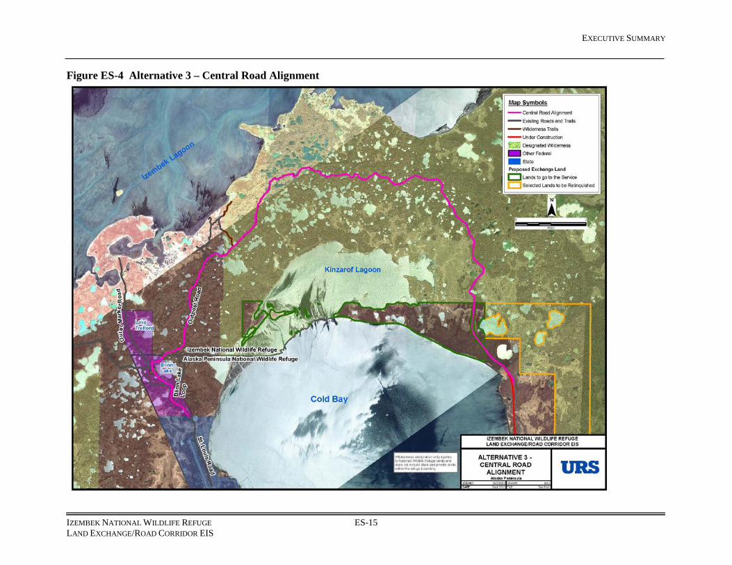
Alternative 3 – Land Exchange and Central Road Alignment Alternative 3 proposes a land exchange between the federal government, State of Alaska, and King Cove Corporation, as described in the Proposed Action. Legal descriptions for exchange parcels are provided in Appendix B. The estimated amount of federal land exchanged in this alternative from Izembek National Wildlife Refuge would be 227 acres, including 152 acres in Izembek Wilderness, assuming a 100-foot corridor width. A constant 100-foot width was used for analysis purposes for this EIS; the final corridor width in the final land exchange documents would have a similar footprint area but would have a variable width, with an average of 100 feet. The variable width would adapt to constraints defined by more detailed engineering, based on a more in depth geotechnical investigation and acquisition of more refined ground surface data.
Under this alternative, the Service would execute an administrative boundary adjustment in the vicinity of Blinn Lake, in accord with ANILCA Section 103(b). An area that is currently designated as Alaska Peninsula National Wildlife Refuge, but administered by Izembek National Wildlife Refuge, would become part of Izembek National Wildlife Refuge (Figure ES-2).
The central road alignment (Figure ES-4, Alternative 3) would originate at the terminus of the King Cove Access Road (currently under construction) in the vicinity of the Northeast Terminal. The initial 6 miles would be co-located with the southern alignment (Alternative 2). The alignment would cross 2 fish bearing streams. At a point 6 miles north of the Northeast Terminal, the central alignment would depart from the southern alignment and wind north and then westerly through steep hills and around lakes of the isthmus divide to Outpost Trail. The alignment would be co-located with the southern alignment, along Outpost Trail (which transitions to Outpost Road) to an intersection north of Blinn Lake. The central alignment would depart from the southern alignment north of Blinn Lake, continuing along Outpost Road to intersect with Outer Marker Road to the west of Blinn Lake. The route would continue south along Outer Marker Road to intersect with St. Louis Road, terminating at the refuge/state boundary.
The central alignment would be located in the watersheds of Izembek and Kinzarof lagoons. The alignment was designed to avoid or minimize impacts to wetlands and high value habitat for breeding, nesting, and migrating waterbirds, to reduce disturbance or impacts to species and habitat in both Izembek and Kinzarof lagoons, while also considering land mammal (caribou, bear, furbearers) movement and habitat use of the isthmus. This alignment seeks to minimize impacts to wetlands and lake-dependent resources, avoid or minimize stream crossings, and to accommodate terrain considerations.
The values used in the comparison of Alternatives 2 and 3, including the number and type of drainage structures, fill quantities, and typical roadway sections and design details presented in tables and figures are estimates calculated for analysis purposes. Final project design and construction details may be different.
The road for Alternative 3 would be classified as a Rural Minor Collector, with rolling terrain and a design speed of 20 miles per hour. It would be a single-lane gravel road with turnouts. The road would include a barrier along both sides of the roadway to prevent vehicles from accessing the Izembek National Wildlife Refuge and Izembek Wilderness lands adjacent to the road.
EXECUTIVE SUMMARY
IZEMBEK NATIONAL WILDLIFE REFUGE ES-15 LAND EXCHANGE/ROAD CORRIDOR EIS
Figure ES-4 Alternative 3 – Central Road Alignment

EXECUTIVE SUMMARY
IZEMBEK NATIONAL WILDLIFE REFUGE ES-16 LAND EXCHANGE/ROAD CORRIDOR EIS
Alternative 4 – Hovercraft Operations from the Northeast Terminal to Cross Wind Cove (Six days per week) Alternative 4 (see Figure ES-5, Alternative 4) is the Proposed Action in the 2003 EIS. This alternative, as proposed in the 2003 EIS, has not been fully implemented to date. However, actions authorized by the Record of Decision are ongoing. Continued activities for development of the access road and the Northeast Terminal were contracted for construction in 2011 and are under construction. The alternative considered in this EIS assumes construction as originally contracted; implementation of the alternative would not require further construction. The alternative will consider operations of the hovercraft, as described in the 2003 EIS, for service 6 days per week between the Northeast Terminal and the Cross Wind Cove. It is acknowledged that the Aleutians East Borough has indicated it will not resume hovercraft service; Alternative 4 does not assume that the Aleutians East Borough would be the operator of this alternative. However, Alternative 4 is retained for analysis, as described in the 2003 EIS.
This alternative would use the existing hovercraft terminal at Cross Wind Cove. The terminal building installed at Lenard Harbor would remain in place, but some materials, including planking, timber mats, generators, and cargo containers (Conex containers) would be re-purposed and installed at the new terminal site. The contract for construction of the access road and Northeast Terminal was established in 2011. These activities were analyzed in the 2003 EIS and no additional ground disturbing activities would be required beyond what was identified in the 2003 EIS. Costs for a hovercraft similar to the Aleutians East Borough hovercraft, Suna X, are included in this analysis.
A land exchange would not occur, though lands previously selected within Izembek Wilderness by the King Cove Corporation under ANSCA could eventually be conveyed.
Alternative 5 – Lenard Harbor Ferry with Cold Bay Dock Improvements Alternative 5 would use a ferry to travel 14 miles between a terminal in Lenard Harbor and a substantially modified Cold Bay dock (Figure ES-6, Alternative 5). This alternative is similar to an alternative that was analyzed in the 2003 EIS, with the exception of project elements that have been permitted or constructed to date, including the access road to the site, a terminal building with associated utility infrastructure, and a parking area. However, the Lenard Harbor terminal structure has been damaged by a storm, and would have to be replaced. Upgrades to the parking area and security fencing would also be necessary. Ferry service would be provided 6 days per week. Alternative 5 would be located on lands owned by King Cove Corporation, The Aleut Corporation, and the State of Alaska. A land exchange would not occur, though lands previously selected within Izembek Wilderness by the King Cove Corporation under ANSCA could eventually be conveyed.

EXECUTIVE SUMMARY
IZEMBEK NATIONAL WILDLIFE REFUGE ES-17 LAND EXCHANGE/ROAD CORRIDOR EIS
Figure ES-5 Alternative 4 (Hovercraft from Northeast Terminal)

EXECUTIVE SUMMARY
IZEMBEK NATIONAL WILDLIFE REFUGE ES-18 LAND EXCHANGE/ROAD CORRIDOR EIS
Figure ES-6 Alternative 5 (Lenard Harbor Ferry with Cold Bay Dock Improvements)

EXECUTIVE SUMMARY
IZEMBEK NATIONAL WILDLIFE REFUGE ES-19 LAND EXCHANGE/ROAD CORRIDOR EIS
Alternative 5 consists of the following major components:
• Lenard Harbor ferry dock, new terminal building, security fencing, and parking lot grading
• Major modification of the existing Cold Bay dock by adding a wave barrier, vehicle ramp system for on- and off-loading vehicles at water level, and a pedestrian walkway
• A displacement monohull, open deck ferry with ice-breaking capabilities
• One material site, 1 disposal site for unusable excavated materials, and 1 temporary barge landing site/staging area required for construction
ES-1.5 Comparison of Alternatives Table ES-2 shows a summary of the five alternatives, including cost. The parcels involved in the proposed land exchange under Alternatives 2 and 3 and other lands potentially affected by these alternatives are listed in Table ES-3. Alternatives 1, 4 and 5 would not include a land exchange. Alternatives 2 and 3 would encumber other federal and private parcels in addition to the exchange lands: an alternate land selection within Alaska Peninsula National Wildlife Refuge, a private parcel in the vicinity of Blinn Lake (Alternative 3 only), and an administrative boundary adjustment between Izembek and Alaska Peninsula National Wildlife Refuges. In addition, upon completion of the land exchange proposed under Alternatives 2 or 3, Izembek State Game Refuge would also include state lands and water in the vicinity of Kinzarof Lagoon, in accord with the Izembek State Game Refuge Land Exchange Bill. Lands potentially affected by the proposed project under Alternatives 1, 4, or 5 are summarized in Table ES-4. Alternatives 1, 4, or 5 would potentially affect federal, state, and private parcels. The lands selected by King Cove Corporation within Izembek Wilderness could eventually be conveyed to the corporation if Alternative 1, 4, or 5 were implemented. Descriptions of the exchange parcels are included in Appendix B. Further description of lands is in included in Chapter 3 and Chapter 4 of the Final EIS.

EXECUTIVE SUMMARY
IZEMBEK NATIONAL WILDLIFE REFUGE ES-20 LAND EXCHANGE/ROAD CORRIDOR EIS
Table ES-2 Comparative Summary of Alternatives
Alternative 1: No Action
Alternative 2: Land Exchange and Southern
Road Alignment
Alternative 3: Land Exchange
and Central Road Alignment
Alternative 4: Hovercraft Operations (No Land Exchange)
Alternative 5: Lenard Harbor Ferry with Cold Bay Dock
Improvements (No Land Exchange)
New Footprint in Acres 0 107 100 0 1.9
Acres Removed from Izembek Wilderness by Land Exchange
0 131 152 0 0
Acres Added to Wilderness by Land Exchange
0 44,491 (includes State
parcel and Kinzarof parcel)
44,491 (includes State
parcel and Kinzarof parcel)
0 0
Acres of Land Selection Relinquished in Wilderness
0 5,430 5,430 0 0
Acres of Land Selection Conveyed
5,430 (in Wilderness)
5,430 (non-Wilderness)
5,430 (non-Wilderness)
5,430 (in Wilderness)
5,430 (in Wilderness)
Estimated Area of Exchange Parcel for Road Corridor
0 201 227 0 0
Acres Removed from Alaska Maritime National Wildlife Refuge (Sitkinak Island)
0 1,619 1,619 0 0
New Acres of Wetlands Filled on Corporation Land
0 1.1 1.1 0 0.4
New Acres of Wetlands Filled in Wilderness
0 2.7 1.3 0 0
Total New Acres of Wetlands Filled
0 3.8 2.4 0 0.4
Capital or Construction Cost in Millions
Unavailable $21.7 $23.7 $11.0 $27.1
Maintenance/ Annual Operation Costs
Unavailable $670,000 $710,000 $2.4 Million $2.6 Million
Lifecycle Cost in Millions
Unavailable $34.2 $37.0 $52.8 $71.7
Capital cost assumptions: Alternative 1: Cost of a future landing craft/passenger ferry $500,000 estimated; other capital costs, maintenance/annual operation costs, and
lifecycle costs are unknown at this time Alternative 2: Cost of road $20,660,000; capital cost to acquire 4 pieces of maintenance equipment $1,000,000 Alternative 3: Cost of road $22,730,000; capital cost to acquire 4 pieces of maintenance equipment $1,000,000 Alternative 4: Cost of hovercraft $9,000,000; cost to ship hovercraft $250,000, deicing modifications $1,400,000, new 120' x 80' hovercraft
heated shelter $300,000 Alternative 5: Cost of ferry $9,000,000 based on similar cost for Ketchikan Ferry ($7.4 m), plus transport to Cold Bay and design, administrative
costs; cost of Lenard Harbor dock facilities $5,600,000; cost of Cold Bay dock modifications $12,500,000

EXECUTIVE SUMMARY
IZEMBEK NATIONAL WILDLIFE REFUGE ES-21 LAND EXCHANGE/ROAD CORRIDOR EIS
Table ES-3 Land Exchange Parcels under Alternatives 2 and 3
Parcel Current Surface Owner Current
Subsurface Owner
Estimated Area
(Acres)
Current Management Regime
Road Corridor Federal –Service and Federal Aviation Administration Federal
201± Alt 2 227± Alt 3
Wilderness and National Wildlife Refuge;
Withdrawal for Federal Aviation Administration
Sitkinak Island Federal – Coast Guard and Service Federal 1,619± Airstrip, Coast Guard Base
State Lands State – Department of Natural Resources State 41,887± General Use
Mortensens Lagoon Native Corporation – King Cove Corporation
Native Corporation – The Aleut Corporation
8,092± Private
Kinzarof Lagoon Native Corporation – King Cove Corporation Federal 2,604± Private
King Cove Corporation Selected Lands
Federal – King Cove Corporation Selection Federal 5,430± Wilderness
Alternate Land Selection in Alaska Peninsula National Wildlife Refuge
Federal Federal 5,430± National Wildlife Refuge
National Wildlife Refuge Boundary Adjustment near Blinn Lake
Federal –Federal Aviation Administration and Service Federal 2,514±
Federal Aviation Administration and
National Wildlife Refuge
RCA Parcel Private (Alternative 3 only) Private 23± Private
Kinzarof Lagoon added to Izembek State Game Refuge
State State 4,320± General Use
Table ES-4 Lands Potentially Affected under Alternatives 1, 4 or 5
Parcel Current Surface Owner Current
Subsurface Owner
Area (Acres) Current Management Regime
Northeast Terminal Site King Cove Corporation, State State No new
footprint Private; construction site
Lenard Harbor Ferry Terminal Site King Cove Corporation, State The Aleut
Corporation, State 0.5 Private
Cold Bay Dock Site State State Less than 0.1 acre
Public Dock (owned by Aleutians East Borough)
King Cove Corporation Selected Lands
Federal – King Cove Corporation Selection Federal 5,430± Wilderness

EXECUTIVE SUMMARY
IZEMBEK NATIONAL WILDLIFE REFUGE ES-22 LAND EXCHANGE/ROAD CORRIDOR EIS
ES-1.6 Summary of Impacts The impact criteria for direct and indirect, and cumulative effects are:
• Intensity – the magnitude of change in the resource condition
• Duration – how long would a change last
• Extent – the geographic area that would be affected
• Context –rare or protected resources that would be affected
The summary ratings shown for each resource are:
• No effect: The alternative would not affect the resource. • Negligible: Impacts are generally extremely low in intensity (often they cannot be
measured or observed), are temporary, localized, and do not affect unique resources. • Minor: Impacts tend to be low intensity, of temporary duration, and local extent, although
common resources may experience more intense, longer-term impacts.
• Moderate: Impacts can be of any intensity or duration, although common and important resources may be affected by higher intensity, longer term, or broader extent impacts. Unique resources may be affected by medium or low intensity impacts, shorter duration or intermittent episodes of impact over a long period, at a local or regional scale.
• Major: Impacts are generally medium or high intensity, long-term or permanent in duration, of regional or extended scope, and affect important or unique resources.
Impacts may be beneficial or adverse. Impacts are generally assumed to be adverse, unless specifically noted. While some impacts are readily evaluated as beneficial or adverse, others may consist of complex trade-offs, including both beneficial and adverse elements. These are characterized as indeterminate. For example, the effects to wilderness under the road alternatives include both removing land from wilderness to construct the proposed road and adding large tracts of land to wilderness. This is a complex trade-off; acres added or removed from wilderness are not the single factor that characterizes the action as either beneficial or adverse. The public comments on the Draft EIS clearly indicated a difference in values regarding some of the potential impacts of the alternatives. Impacts to public health and safety, wildlife, wetlands, wilderness, and subsistence are among the key elements of the decision to be made in this EIS. Where there are notable trade-offs, the effects are disclosed, but the deciding officer will make the evaluation of the character of the impact.
Table ES-5 shows a narrative summary of direct, indirect, and cumulative impacts for each alternative, by resource. Several resources analyzed in detail in Chapter 4 of the EIS do not appear in Table ES-5 because the effects were minor or less for all alternatives. The effects for air quality, climate, hazardous materials, noise, marine mammals, socioeconomics, environmental justice, subsistence, and cultural resources are all at a minor level or less across all alternatives. (The analysis for noise does acknowledge temporary moderate impacts during the construction stage, but the overall effect for noise was considered minor.)
The following paragraphs provide a brief narrative overview of generalized impact analysis conclusions. See Chapter 4 of the Final EIS for the complete analysis of impacts.

EXECUTIVE SUMMARY
IZEMBEK NATIONAL WILDLIFE REFUGE ES-23 LAND EXCHANGE/ROAD CORRIDOR EIS
Alternative 1 – No Action Effects would generally be negligible to minor. The negligible to minor effects are generally associated with the indirect effects of the potential conveyance of approximately 5,430 acres in Izembek Wilderness to King Cove Corporation selected under ANCSA. King Cove Corporation’s right to select the parcel in Izembek Wilderness pre-dates the establishment of the wilderness. Effects of potential future landing craft/passenger ferry service are generally negligible or not able to be calculated, due to insufficient detail regarding potential plans of operation.
Alternative 2 – Land Exchange and Southern Road Alignment and Alternative 3 – Land Exchange and Central Road Alignment The analysis of impacts for Alternatives 2 and 3 are very similar. While there is some variation in the potential impacts based on the different alignments, both alternatives would have major beneficial effects to public health and safety and transportation with the addition of surface transportation for people in the City of King Cove to travel to the Cold Bay Airport for access to advanced medical services and other destinations. The road alternatives would result in distinctive changes to transportation options, patterns, and costs, and add a full-time transportation link between the communities of King Cove and Cold Bay.
Alternatives 2 and 3 would have major adverse effects to birds and land mammals. Tundra Swans, Brant, and Emperor Geese would be adversely affected by habitat fragmentation and habitat avoidance, increased human and predator access, and risk of injury or mortality from vehicle collisions. Brown bears would be adversely affected; behavior changes are estimated due to increased human access and potential collisions with vehicles.
The proposed exchange of federal, state, and King Cove Corporation lands would have a major indeterminate impact to Izembek Wilderness; approximately 131 acres would be removed from Izembek Wilderness under Alternative 2 and 152 acres would be removed under Alternative 3 for the respective road corridors, which would fragment the wilderness and impact natural quality, undeveloped quality, and opportunities for solitude. Approximately 44,491 acres would be added to Alaska Peninsula National Wildlife Refuge as wilderness under either alternative. The parcel selected by King Cove Corporation (5,430 acres) would be retained in Izembek Wilderness.
The Service and the State would have major (indeterminate) changes in land ownership and management due to the land exchange, construction, and operation of the road. The King Cove Corporation would have a major change in land ownership. The major (indeterminate) changes in public use include changes in management of the parcels proposed for exchange and the public use of those lands and surrounding lands. The land exchange would affect public use on the parcels previously managed as state or private land which would become national wildlife refuge or national wildlife refuge wilderness.
Alternatives 2 and 3 would diminish the ability of the Service to meet the first, second, and fourth of the refuge purposes identified in Public Land Order 2216 and ANILCA. These purposes are:
• To conserve fish and wildlife populations and habitats in their natural diversity...;

EXECUTIVE SUMMARY
IZEMBEK NATIONAL WILDLIFE REFUGE ES-24 LAND EXCHANGE/ROAD CORRIDOR EIS
• to fulfill the international treaty obligations of the U.S. with respect to fish and wildlife and their habitats;
• to ensure, to the maximum extent practicable and in a manner consistent with the purposes set forth in paragraph (i), water quality and necessary water quantity within the Refuge.
Alternatives 2 and 3 would also diminish the ability of the Service to meet the second and third of the refuge purposes identified in the Wilderness Act. These purposes are:
• to protect and preserve the wilderness character of areas within the National Wilderness Preservation System; and
• to administer [the areas] for the use and enjoyment of the American people in a way that will leave them unimpaired for futures use and enjoyment as wilderness.
Alternative 4 – Hovercraft Operations from the Northeast Terminal to Cross Wind Cove (Six days per week) The effects from implementation of Alternative 4 would generally be negligible to minor. However, effects to public health and safety would be major (beneficial), and effects to transportation and wilderness would be moderate (indeterminate and adverse, respectively). While the hovercraft would require an annual subsidy of approximately $2.2 million, it is not assumed that the Aleutians East Borough would be the operator for this alternative. Thus, effects to local fiscal resources are considered negligible. The major beneficial effects to public health and safety and the moderate beneficial effects to transportation would result from regularly scheduled year round transportation from the City of King Cove to the Cold Bay Airport, and the availability of the hovercraft for most emergency medical evacuations. Minor to moderate adverse effects to wilderness would result from increased hovercraft operations; intermittent noise or visual disturbances would occur in localized areas, which would affect wilderness qualities.
Negligible to minor adverse effects to other resources would be similar to Alternative 1, resulting from ongoing operations of the hovercraft and the eventual conveyance of approximately 5,430 acres in Izembek Wilderness to King Cove Corporation, fulfilling a selection under ANCSA.
Alternative 5 – Lenard Harbor Ferry with Cold Bay Dock Improvements Effects from implementation of Alternative 5 would be similar to Alternative 4 in that there would be negligible effects to local fiscal resources, major beneficial effects to public health and safety, moderate indeterminate effects to transportation, and negligible to minor effects to other resources. The negligible effects to local fiscal resources assumed that the Aleutians East Borough would not be the operator of the alternative. However, the operation of the ferry would require annual funding of approximately $2.6 million. The major beneficial effects to public health and safety and the moderate indeterminate effects to transportation would result from regularly scheduled year round transportation from the City of King Cove to the Cold Bay dock, and the availability of the ferry for most emergency medical evacuations. Negligible to minor adverse effects to other resources would include impacts associated with the construction and new footprint of the Lenard Harbor ferry terminal, improvements to the Cold Bay dock, and disturbance due to operations of the ferry.

EXECUTIVE SUMMARY
IZEMBEK NATIONAL WILDLIFE REFUGE ES-25 LAND EXCHANGE/ROAD CORRIDOR EIS
ES-1.7 Substantial Changes between Draft and Final EIS
Changes to Alternatives Under the No Action alternative in the Draft EIS, seasonal hovercraft service was assumed to operate between the Northeast Terminal and Cross Wind Cove. As noted in the Draft EIS, the Service indicated the No Action alternative would be revised in the Final EIS. Appendix I of the Final EIS contains correspondence related to the No Action alternative. In the Final EIS, the No Action alternative assumes existing modes of transportation would continue to operate, including air, personal marine vessels, state ferry service twice per month from late spring through early fall, and construction of infrastructure to support a marine-road link. The marine component of the marine-road link has not operated since November 2010, but could be re-instated by a landing craft/passenger ferry in the future if the land exchange is not approved (AEB 2012). The description of the No Action alternative is in Chapter 2 and assumptions for analysis are included in Chapter 4 of the Final EIS. Table ES-5, which displays the summary of impacts by alternative, was revised.
Characterization of Effects The discussion of impacts has been expanded in Chapter 4 of the Final EIS. While some impacts are readily evaluated as beneficial or adverse, others may consist of complex trade-offs, including both beneficial and adverse elements. These are characterized as indeterminate. For example, the effects to designated wilderness under the road alternatives include both removing land from wilderness to construct the proposed road and adding large tracts of land to wilderness. This is a complex trade-off; acres added or removed from wilderness are not the single factor that characterizes the action as either beneficial or adverse. The public comments on the Draft EIS clearly indicated a difference in values regarding some of the potential impacts of the alternatives. Impacts to public health and safety, wildlife, wetlands, wilderness, and subsistence are among the key elements of the decision to be made in this EIS. Where there are notable trade-offs, the effects are disclosed, but the deciding officer will make the evaluation of the character of the impact for those resources that are characterized as indeterminate. Impacts are assumed to be adverse, unless noted as beneficial or indeterminate.
The effects analysis for Alternative 1 was revised to reflect the current configuration of the alternative.
Additional Data and Revisions to Analysis An analysis was conducted on past impacts from all-terrain vehicle use in and around Izembek National Wildlife Refuge and was included in the transportation section in Chapter 3 (Section 3.3.3.1). During annual aerial surveys along fixed flight paths to monitor wildlife populations, notable changes to vegetation were observed and documented over a three-year period. Existing all-terrain vehicle routes were mapped. Using this baseline information, the potential for future impacts of all-terrain vehicles was modeled and is displayed in Chapter 4 (Section 4.3.3.1).
Known sources of mineral resources (sand, gravel, etc.) were identified in the literature and included in the Chapter 3 of the Final EIS. The description of the area designated as a Wetland of International Importance under the Ramsar Convention was revised in Chapter 3 of the Final EIS, clarifying that the area includes the entire Izembek National Wildlife Refuge.

EXECUTIVE SUMMARY
IZEMBEK NATIONAL WILDLIFE REFUGE ES-26 LAND EXCHANGE/ROAD CORRIDOR EIS
Summaries of conservation concerns were added to Fish, Land Mammals, and Marine Mammals analyses, similar to other sections of the Biological Environment (Chapter 3 of the Final EIS). The population status of the Southern Alaska Peninsula Caribou Herd was updated; while the population remains low, it reached management objectives to allow a limited subsistence hunt in 2012. Descriptions of the State’s predator control program were also updated.
An analysis of potential impacts to Tundra Swans was received. The analysis considered two potential buffers for impacts. These data were reviewed and incorporated in the analysis (Chapter 4 of the Final EIS). In addition, potential impacts from all-terrain vehicle use were modeled for Tundra Swans and Brant and incorporated into Chapter 4 of the Final EIS.
The effects to biological resources due to the exchange of parcels were evaluated, based on comments on the Draft EIS. Changes in habitat and population are evaluated for the project area, separate from changes in land status. Existing resources on the proposed exchange parcels would generally not be affected by the change in land ownership. Effects related to land ownership and management are discussed in social environment sections. The land use section in Chapter 4 was re-written to better describe the proposed lands for exchange in the context of refuge purposes. Throughout the effects analysis of Chapter 4, the terms used to evaluate the impact analysis were better defined and quantified in the summary paragraphs.
The discussion of ANCSA 22(g) provisions was revised, in relation to its effects on land status and potential future development in Chapters 3 and 4. The land use section in Chapter 4 was revised to include an analysis of effects to refuge purposes. Socioeconomic data were revised in Chapter 3 of the Final EIS to incorporate 2010 Census data and other available updated statistics. The Socioeconomic and Public Health and Safety sections (Chapter 3 of the Final EIS) were revised to include a section on public concerns related to transportation safety, availability, and weather conditions. A summary of government to government consultation with potentially affected Federally Recognized Tribes was added to Chapter 3 of the Final EIS.
More recent harvest data and subsistence use area maps for Nelson Lagoon and False Pass were provided in pre-publication versions of reports by Dr. Reedy-Maschner and were included in Chapter 3 of the Final EIS.
At the time of the Draft EIS, a field survey for cultural resources was not completed. The Service and the State Historic Preservation Office cooperated in conducting a field survey of the two proposed road alignments during August 2012. The survey identified two World War II “camps” adjacent to Outpost trail. The results of the field survey are included in the Final EIS (Appendix H).
The discussion of the effect of Kinzarof Lagoon entering the State Game Refuge System has been expanded in the Biological and Social Environment of Chapters 3 and 4 of the Final EIS.
The effects analysis for the No Action alternative was revised to reflect the current configuration of the alternative (Chapter 4 of the Final EIS). The assumption of dedicated transportation for a seafood processor was removed. Emissions from the State ferry were removed from the Air Quality analysis sections in Chapter 4 of the Final EIS, as the effect was common to all alternatives. The discussion of the percentages of land affected by alternative has been removed.
The analysis of the effects of the potential conveyance of the selected parcel to King Cove Corporation was revised for consistency in Alternatives 1, 4, and 5. The selection of the parcel is an existing condition; the right to select this parcel predates the establishment of Izembek

EXECUTIVE SUMMARY
IZEMBEK NATIONAL WILDLIFE REFUGE ES-27 LAND EXCHANGE/ROAD CORRIDOR EIS
Wilderness. Potential development of the parcel would be subject to ANCSA Section 22(g) and to the compatibility requirements of 50 CFR Parts 25 and 26. The conveyance of the parcel is analyzed as an indirect effect of Alternatives 1, 4, and 5 (Chapter 4 of the Final EIS).
The analysis for birds and land mammals was re-evaluated for Alternatives 2 and 3. The summary impact ratings had few changes for these sections, but additional information is provided for the analysis. The summary impact for seabirds was re-evaluated and reduced from minor to negligible for seabirds under Alternatives 2 and 3. The effects determination for fish and Essential Fish Habitat was changed from major to moderate under Alternatives 2 and 3, based on implementation of mitigation measures. The summary impacts for Environmental Justice were revised to reflect the terms of Executive Order 12898; the summary conclusion for all alternatives is no disproportionate adverse effect.
Revisions or Additions to Appendices Appendix B was updated with text clarifications. Paragraphs were added relative to two parcels on the western end of the proposed road alignments under ownership by RCA Alaska Communications, Incorporated and under Federal Aviation Administration management.
Appendix D was updated with text clarifications. The ANILCA 810 analysis considers only subsistence uses and needs on federal lands; cultural practices on state and private lands not under federal subsistence management are not included in the analysis. Characterization of the lands potentially affected by the alternatives was revised. The description of the federal subsistence priority under Title VIII of ANILCA and the description of subsistence access under ANILCA 811 were also revised. The finding was not revised; none of the alternatives would result in a significant restriction of subsistence uses and needs on federal lands.
Sheet 19 of Appendix E was revised to depict the location of the parcel owned by RCA Alaska Communications, Incorporated.
The mitigation measures in Appendix F were substantially revised. The mitigation measures were organized thematically and revised in response to comments from the EPA, Service and cooperating agencies, including potentially responsible parties for implementation. In addition, consistent with recent guidance from the Council on Environmental Quality, the table was expanded to include the responsible party, timeframe for implementation, and likelihood of effective implementation.
Appendix G, the Comment Analysis and Response Report, is an addition to the EIS. The appendix contains a summary of comments on the Draft EIS, organized by statements of concern and responses to the comments. The appendix also contains an index to unique submissions and a summary of the comments of each unique submission. A summary of the statements of concern identified in form letters is provided. Sample comment letters, including comments from the cooperating agencies are included.
Appendix H, Cultural Resource Report, is an addition to the EIS. At the time of the Draft EIS, a field survey for cultural resources was not completed. The Service and the State Historic Preservation Office cooperated in conducting a field survey of the two proposed road alignments during August 2012. The survey identified two World War II “camps” adjacent to Outpost trail. The report was prepared by the State Office of History and Archaeology and documents a reconnaissance level cultural resource survey of the proposed road alignments.
EXECUTIVE SUMMARY
IZEMBEK NATIONAL WILDLIFE REFUGE ES-28 LAND EXCHANGE/ROAD CORRIDOR EIS
Appendix I, Correspondence Concerning the No Action Alternative, is an addition to the EIS. This appendix contains a list and the complete text of the correspondence related to the No Action alternative.
Appendix J, Cooperating Agency Correspondence Related to the Preferred Alternative, is an addition to the EIS. This appendix contains recommendations received by the Service from cooperating agencies related to the Preferred Alternative.

EXECUTIVE SUMMARY
IZEMBEK NATIONAL WILDLIFE REFUGE LAND EXCHANGE/ROAD CORRIDOR EIS ES-29
Table ES-5 Direct, Indirect, and Cumulative Effects by Alternative and Resource
Alternative 1:
No Action
Alternative 2: Land Exchange and
Southern Road Alignment
Alternative 3: Land Exchange and
Central Road Alignment
Alternative 4: Hovercraft Operations from the
Northeast Terminal to Cross Wind Cove 6 days
per Week
Alternative 5: Lenard Harbor Ferry with Cold Bay Dock Improvement
Geology and Soils
Overall Effects Alternative 1 would result in no effects on geology and soils in the project area. The potential effects from future landing craft operations cannot be quantified.
Though impacts from Alternative 2 would be reduced in the period following the project completion, construction would disturb a total of 107 acres of surface and shallow subsurface soil along the road corridor and less than 1 acre at a construction staging area near the Northeast Terminal and 6 acres at a material site on King Cove Corporation lands. Approximately 111,000 cubic yards of material would be excavated during cut and fill activities. The effect would be moderate.
Effects of Alternative 3 would be similar to those in Alternative 2, disturbing a total of 100 acres of surface and shallow subsurface soil along the road corridor and less than 1 acre at a construction staging area near the Northeast Terminal and 7 acres at a material site on King Cove Corporation lands. Approximately 99,000 cubic yards of material would be excavated during cut and fill activities. The effect would be moderate.
Effects may include shoreline erosion from wave action generated by the hovercraft during departures and arrivals. Because of the frequency of the hovercraft operation, the effect would be negligible to minor.
There would be no effects on geology and soils from operation and maintenance of a ferry. Minor effects would occur due to dock construction activities, because of the disturbance to submerged sediments as a result of dredging and pile driving. Less than 1 acre of land would be disturbed.
Cumulative Effects
With no direct or indirect effects to geology and soils expected under Alternative 1, there would be no contribution to cumulative effects on these resources. Landing craft effects cannot be quantified at this time.
The resulting erosion of soil in areas disturbed by construction or staging could lead to water channelization of runoff, and would add to existing effects on geology and soil resources. The cumulative effect would be moderate.
Cumulative effects would be similar to those discussed under Alternative 2, moderate.
The incremental addition to cumulative effects would be negligible.
There would be negligible incremental additions to cumulative effects as a result of construction activities on less than 1 acre at the Lenard Harbor site.

EXECUTIVE SUMMARY
IZEMBEK NATIONAL WILDLIFE REFUGE LAND EXCHANGE/ROAD CORRIDOR EIS ES-30
Alternative 1:
No Action
Alternative 2: Land Exchange and
Southern Road Alignment
Alternative 3: Land Exchange and
Central Road Alignment
Alternative 4: Hovercraft Operations from the
Northeast Terminal to Cross Wind Cove 6 days
per Week
Alternative 5: Lenard Harbor Ferry with Cold Bay Dock Improvement
Hydrology/Hydrologic Processes
Overall Effects Alternative 1 would have no direct or indirect effect on hydrologic resources. If landing craft service is implemented at some date in the future, this could result in negligible effects.
Effects to hydrologic resources would occur as a result of fill placement in approximately 3.8 acres of wetland, and the installation of an estimated 162 drainage structures along the road. The uncontained release of hazardous materials and from stream turbidity generated by streambank construction activities could also occur. The increase in sediment load from road runoff would impact the quality of water bodies which are considered Essential Fish Habitat. The effect would be moderate.
Effects to hydrologic resources would occur as a result of fill placement in approximately 2.4 acres of wetland, and the installation of an estimated 173 drainage structures along the road. The uncontained release of hazardous materials and from stream turbidity generated by streambank construction activities could also occur. The increase in sediment load from road runoff would impact the quality of water bodies which are considered Essential Fish Habitat. The effect would be moderate.
Impacts to hydrologic resources related to the implementation of Alternative 4 would result in negligible effects. These effects may include fuel and sewage releases at the docking locations and along the preferred routes.
The greatest impacts to hydrologic resources, particularly water quality, would include increase in turbidity due to dredging and pile driving activities at the Lenard Harbor ferry terminal and modifications at the Cold Bay Dock and refueling of the ferry in open water. As construction would be limited to less than 1 acre, activities would have negligible effects on hydrologic resources within the project area. Effects from operation and maintenance of a ferry could include effects from the release of hazardous materials would also be negligible.
Cumulative Effects
Alternative 1 would have no contribution to cumulative effects on these resources. If landing craft service is implemented at some date in the future, this could result in negligible effects.
Long-term maintenance of stream crossings would be additive to those impacts derived during construction activities. Effects could include potential non-point source pollution and unlawful stream crossings along the margins of the road corridor by the general public. Effects would be moderate.
The contribution to cumulative effects would be similar to those described under Alternative 2, moderate.
The incremental addition to cumulative effects on hydrologic resources would be negligible due to potential fuel and sewage releases at the docking locations and along the preferred routes.
There would be negligible incremental additions to cumulative effects on water resources and water quality within Cold Bay. The impacts from ferry vessels may include fuel and sewage releases at the docking locations and along the preferred routes of the ferry vessels.

EXECUTIVE SUMMARY
IZEMBEK NATIONAL WILDLIFE REFUGE LAND EXCHANGE/ROAD CORRIDOR EIS ES-31
Alternative 1:
No Action
Alternative 2: Land Exchange and
Southern Road Alignment
Alternative 3: Land Exchange and
Central Road Alignment
Alternative 4: Hovercraft Operations from the
Northeast Terminal to Cross Wind Cove 6 days
per Week
Alternative 5: Lenard Harbor Ferry with Cold Bay Dock Improvement
Terrestrial and Aquatic Plant Communities
Overall Effects There would be minor (indirect) effects on vegetation from conveyance of the King Cove Corporation selected lands.
Construction would cause the loss of approximately 107 acres of native plant communities along the proposed road corridor and the loss of approximately 1 acre of native vegetation at 2 temporary barge landing sites. The overall effect would be moderate.
Construction would cause the loss of approximately 100 acres of native plant communities along the proposed road corridor and the loss of approximately 1 acre of native vegetation at 2 temporary barge landing sites. The overall effect would be moderate.
Operation of the hovercraft from the Northeast Terminal may create more opportunity for the spread of invasive species in the Izembek National Wildlife Refuge vicinity. Potential development associated with the conveyance of King Cove Corporation selected land could alter vegetation in the local area. The effect would be minor.
Invasive species are located in Cold Bay and are also likely present in the King Cove vicinity. These species may be transported to new locations by operation of the ferry. Potential development associated with the conveyance of King Cove Corporation selected land could alter vegetation in the local area. The effect would be minor.
Cumulative Effects
Alternative 1 would make a minor contribution to cumulative effects to vegetation from the conveyance of the King Cove Corporation selected lands.
The completion of the road to the Northeast Terminal would contribute to effects on vegetation. The opportunity for invasive species to spread within the Izembek National Wildlife Refuge vicinity would increase. Cumulative effects would be moderate.
Cumulative effects would be similar to those discussed under Alternative 2, moderate.
Alternative 4 would make a minor contribution to cumulative effects to vegetation from the conveyance of the King Cove Corporation selected lands.
Less than 1 acre of native shoreline plant communities would be affected during construction. Indirect effects could include the transportation of invasive species to new locations by operation of the ferry. The selected parcel could be conveyed to King Cove Corporation. Alternative 1 would make a minor contribution to cumulative effects to vegetation.

EXECUTIVE SUMMARY
IZEMBEK NATIONAL WILDLIFE REFUGE LAND EXCHANGE/ROAD CORRIDOR EIS ES-32
Alternative 1:
No Action
Alternative 2: Land Exchange and
Southern Road Alignment
Alternative 3: Land Exchange and
Central Road Alignment
Alternative 4: Hovercraft Operations from the
Northeast Terminal to Cross Wind Cove 6 days
per Week
Alternative 5: Lenard Harbor Ferry with Cold Bay Dock Improvement
Wetlands
Overall Effects Alternative 1 would result in minor (indirect) effects on wetlands from conveyance of the King Cove Corporation selected lands.
An estimated total of 3.8 acres of wetland would be filled and 162 drainage structures would be constructed. The effect of modifications to wetland hydrology and vegetation would be moderate.
An estimated total of 2.4 acres of wetland would be filled and 173 drainage structures would be constructed. The effect of modifications to wetland hydrology and vegetation would be moderate.
Effects would be similar to Alternative 1, with minor effects from the conveyance of the King Cove Corporation selected lands.
The result of construction of Alternative 5 would include the loss of wetland or wetland functions on less than 1 acre of beach system wetlands. Minor indirect effects to wetlands could result from conveyance of the King Cove Corporation selected lands similar to Alternative 1. The operation of a ferry would not have any effect on wetlands. The overall impact would be minor.
Cumulative Effects
Alternative 1 would make a minor contribution to cumulative effects to wetlands from the conveyance of the King Cove Corporation selected lands.
The completion of the road to the Northeast Terminal would contribute to effects on wetlands. Cumulative effects would be moderate.
Effects would be similar to Alternative 2, moderate.
Effects would be similar to Alternative 1, with a minor contribution to cumulative effects to wetlands from the conveyance of the King Cove Corporation selected lands.
Less than 1 acre of wetlands would be affected during construction. Other contributions to cumulative effects would be similar to Alternative 1, due to the conveyance of the King Cove Corporation selected lands. Cumulative effects would be minor.

EXECUTIVE SUMMARY
IZEMBEK NATIONAL WILDLIFE REFUGE LAND EXCHANGE/ROAD CORRIDOR EIS ES-33
Alternative 1:
No Action
Alternative 2: Land Exchange and
Southern Road Alignment
Alternative 3: Land Exchange and
Central Road Alignment
Alternative 4: Hovercraft Operations from the
Northeast Terminal to Cross Wind Cove 6 days
per Week
Alternative 5: Lenard Harbor Ferry with Cold Bay Dock Improvement
Fish and Essential Fish Habitat
Overall Effects There would be no new effects on fish and essential fish habitat. If landing craft service is implemented at some date in the future, this would result in negligible effects.
Alternative 2 involves 8 crossings of anadromous or fish-bearing streams, but construction effects to anadromous species habitat are not anticipated to be measurable. Unavoidable indirect effects such as erosion from record storm events and pollution from anthropogenic causes could occur. The effect could be moderate.
Alternative 3 involves 2 crossings of anadromous or fish-bearing streams, but effects to anadromous species habitat are not anticipated to be measurable. Unavoidable indirect effects such as erosion from record storm events and pollution from anthropogenic causes could occur. The effect could be moderate.
The combined effects on fish and fish habitat under Alternative 4 would primarily result from hovercraft noise. Effects would be considered negligible.
It is unlikely that Essential Fish Habitat would be affected by dock construction or ferry operation. The effect would be negligible.
Cumulative Effects
Effects from a possible landing craft operation at some future date would be primarily associated with vessel noise, which would be a negligible contribution to cumulative effects on fish and Essential Fish Habitat under Alternative 1.
Cumulative effects would include unavoidable indirect effects such as reduction in water quality through erosion, sedimentation, and pollution from vehicles and other anthropogenic sources. The cumulative effect would be moderate.
Cumulative effects would be similar to those discussed under Alternative 2, moderate.
Effects would be similar to Alternative 1, negligible.
Effects would be similar to Alternative 1, and considered negligible.

EXECUTIVE SUMMARY
IZEMBEK NATIONAL WILDLIFE REFUGE LAND EXCHANGE/ROAD CORRIDOR EIS ES-34
Alternative 1:
No Action
Alternative 2: Land Exchange and
Southern Road Alignment
Alternative 3: Land Exchange and
Central Road Alignment
Alternative 4: Hovercraft Operations from the
Northeast Terminal to Cross Wind Cove 6 days
per Week
Alternative 5: Lenard Harbor Ferry with Cold Bay Dock Improvement
Birds
Overall Effects Alternative 1 would result in minor (indirect) effects on birds from conveyance of the King Cove Corporation selected lands. If landing craft service is implemented at some date in the future, this would result in an additional negligible increment of effects to birds. The overall effect would be minor.
Alternative 2 would have a major effect on Tundra Swans, Brant, and Emperor Geese. Effects to other breeding birds would be minor in the project area moderate to major near the road. Effects on other migrating/wintering birds would be moderate, and negligible effects on seabirds.
Alternative 3 would have a major effect on Tundra Swans, Brant, and Emperor Geese, moderate effects on other breeding birds and other migrating/wintering birds, and negligible effects on seabirds.
Alternative 4 could affect short-term behavior for seabirds and waterfowl. The overall effect would be minor.
Alternative 5 could affect short-term behavior for seabirds and waterfowl. Oil or other contaminant leaks are possible. Because the ferry would operate once a day, and the risk of spills is small, the overall effect would be minor.
Cumulative Effects
Alternative 1 would make a minor contribution to cumulative effects to birds from the conveyance of the King Cove Corporation selected lands.
Alternative 2 would increase human access, hunting pressure, and disturbance for birds, causing displacement from feeding or nesting areas. Alternative 2 would contribute a major to moderate contribution to cumulative effects on Tundra Swans, Brant, Emperor Geese, and other migrating/wintering birds, a moderate effect on most other breeding birds, and negligible effect on seabird species.
Cumulative effects would be similar to those discussed under Alternative 2, a major to moderate contribution to cumulative effects on Tundra Swans, Brant, Emperor Geese, and other migrating/wintering birds, a moderate effect on most breeding birds, and negligible effect on seabird species.
Alternative 4 would make a minor contribution to cumulative effects to birds from the conveyance of the King Cove Corporation selected lands
Less than 1 acre would be affected during construction. Other contributions to cumulative effects would be similar to Alternative 1, due to the conveyance of the King Cove Corporation selected lands. The contribution of Alternative 5 to cumulative effects on birds is considered minor.

EXECUTIVE SUMMARY
IZEMBEK NATIONAL WILDLIFE REFUGE LAND EXCHANGE/ROAD CORRIDOR EIS ES-35
Alternative 1:
No Action
Alternative 2: Land Exchange and
Southern Road Alignment
Alternative 3: Land Exchange and
Central Road Alignment
Alternative 4: Hovercraft Operations from the
Northeast Terminal to Cross Wind Cove 6 days
per Week
Alternative 5: Lenard Harbor Ferry with Cold Bay Dock Improvement
Land Mammals
Overall Effects Alternative 1 would result in minor (indirect) effects on land mammals from conveyance of the King Cove Corporation selected lands. There would be no direct effects on land mammals from construction or operation and maintenance. If landing craft service is implemented at some date in the future, this would result in negligible effects. The overall effect to land mammals would be minor.
Behavior changes, increased human access, and collisions with vehicles could occur with the Alternative 2 road. Effects to brown bears are considered major. The effects to caribou would be moderate, but the effects could be major if caribou migration is interrupted. However, the likelihood of that outcome is judged to be low. The overall effect would be minor for small mammals and furbearers and moderate for other large mammals.
The effects of Alternative 3 are similar to that of Alternative 2. The road's central route could increase potential effects to migrating caribou, and essentially bisects large mammal habitat between Izembek and Kinzarof lagoons. Effects to brown bears are considered major. The effects to caribou would be moderate, but the effects could be major if caribou migration is interrupted. However, the likelihood of that outcome is judged to be low. The overall effect would be minor for small mammals and furbearers and moderate for large mammals.
The noise and sight of the hovercraft as it begins operations at the Northeast Terminal and lands at Cross Wind Cove may startle land mammals, causing them to alter their behavior briefly. Because the frequency of disturbance is low, the summary impact would be minor.
Although the noise and sight of construction and the operation of the ferry may temporarily startle land mammals, it would be a predictable disturbance occurring in a limited area. Human activities at the Lenard Harbor Ferry Terminal and Cold Bay Dock would likely have a negligible effect on land mammals, but the effects on caribou from construction of the terminal could be minor.
Cumulative Effects
The conveyance of the King Cove Corporation selected lands would result in minor indirect effects. The overall contribution of Alternative 1 to cumulative effects is considered minor.
Alternative 2 would increase human access, hunting pressure, and disturbance for land mammals, causing displacement from caribou migration patterns or bear feeding areas. The contribution to cumulative effects would be moderate for large mammals and minor for small mammals and furbearers.
Cumulative effects associated with Alternative 3 would be similar to those associated with Alternative 2. Although potential direct and indirect impacts to caribou could be greater under Alternative 3 because of more proximity to migration patterns, the contribution to cumulative impacts would remain moderate for large mammals and minor for small mammals and furbearers.
Human activities would cause increased disturbance to land mammals in the vicinity of the hovercraft terminal areas. The conveyance of the King Cove Corporation selected lands would result in minor indirect effects. Alternative 4 would result in a minor contribution to cumulative effects on land mammals.
Less than 1 acre would be affected during construction. Other contributions to cumulative effects would be similar to Alternative 1, due to the conveyance of the King Cove Corporation selected lands. The contribution of Alternative 5 to cumulative effects on land mammals is considered negligible.

EXECUTIVE SUMMARY
IZEMBEK NATIONAL WILDLIFE REFUGE LAND EXCHANGE/ROAD CORRIDOR EIS ES-36
Alternative 1:
No Action
Alternative 2: Land Exchange and
Southern Road Alignment
Alternative 3: Land Exchange and
Central Road Alignment
Alternative 4: Hovercraft Operations from the
Northeast Terminal to Cross Wind Cove 6 days
per Week
Alternative 5: Lenard Harbor Ferry with Cold Bay Dock Improvement
Threatened and Endangered Species
Overall Effects With no new activities from operation and maintenance of transportation methods, beyond those already existing, Alternative 1 would have no direct or indirect effects on threatened and endangered species from operation and maintenance. Effects from a future landing craft/passenger ferry service cannot be determined at this time.
Construction and operation of the southern road corridor could disturb Steller’s Eiders and Yellow-billed Loons from the fall through spring. Eiders are particularly vulnerable to disturbance during pre-migration staging in the spring and the fall molt in the fall. Kittlitz’s Murrelets could be disturbed during the breeding season but the disturbance would be limited to occasional flyovers as they are not expected to nest near the road corridor. Construction and operation could elicit disturbance responses from sea otters using northern Kinzarof Lagoon during the summer months. There would be no effect to sea lions, as they do not normally occur in the project area. The overall effect to other threatened and endangered species would be minor, except for Steller’s Eiders, which would experience moderate effects.
The central road alignment could lead to an increase in waterfowl hunting pressure in Izembek Lagoon due to improved access for foot and all-terrain vehicle travel. Izembek Lagoon is an important molting area for thousands of Steller’s Eiders in the fall, coinciding with the timing of waterfowl hunting for Brant and other species. The direct and indirect impacts from construction are considered to be negligible to minor. Direct and indirect effects from operation and maintenance are considered moderate for Steller’s Eiders and minor for Yellow-billed Loon, and negligible to minor for Kittlitz’s Murrelet. Similar to Alternative 2, the effects on sea otters would be minor, with no effects to Steller sea lions.
Given the mitigating restrictions under which the hovercraft would operate, particularly the exclusion zone in northern Cold Bay, disturbance effects on Steller’s Eiders, Yellow-billed Loons, Kittlitz’s Murrelets, northern sea otters, and Steller sea lions from the operation and maintenance of the hovercraft as proposed under Alternative 4 would be negligible to minor.
Noise generated from construction activities, including pile-driving, associated with modifications to the existing Cold Bay dock may disturb Steller’s Eiders, Yellow-billed Loons, or Kittlitz’s Murrelets. However, these species are not present for most of the summer construction season and/or do not frequent the dock area, which would minimize impacts. Construction would have negligible effects to northern sea otters and Steller sea lions. Operations would elicit noise similar to fishing vessels already operating in the area, and the ferry would be slow-moving enough that wildlife could avert collisions. Effects to threatened and endangered species would be negligible to minor.
Cumulative Effects
Alternative 1 would result in no contribution to cumulative effects on these resources. The effects from a possible landing craft operation at some future date cannot be determined.
The contribution to cumulative effects of this alternative would be moderate for Steller’s Eider, and negligible to minor for Yellow-billed Loon, Kittlitz’s Murrelet, and northern sea otters, and no contribution to cumulative effects for Steller sea lions.
The contribution to cumulative effects of this alternative would be moderate for Steller’s Eider, negligible to minor for Yellow-billed Loon, Kittlitz’s Murrelet, and northern sea otters, and no contribution to cumulative effects for Steller sea lions.
The contribution to cumulative effects of this alternative would be negligible to minor for Steller’s Eider due to the speed and noise of hovercraft operations. Effects would be negligible for northern sea otters, and Steller sea lions.
The contribution to cumulative effects of this alternative would be negligible for Steller’s Eider, northern sea otters, and Steller sea lions.

EXECUTIVE SUMMARY
IZEMBEK NATIONAL WILDLIFE REFUGE LAND EXCHANGE/ROAD CORRIDOR EIS ES-37
Alternative 1:
No Action
Alternative 2: Land Exchange and
Southern Road Alignment
Alternative 3: Land Exchange and
Central Road Alignment
Alternative 4: Hovercraft Operations from the
Northeast Terminal to Cross Wind Cove 6 days
per Week
Alternative 5: Lenard Harbor Ferry with Cold Bay Dock Improvement
Land Ownership and Management
Overall Effects Under Alternative 1, a road connecting the communities of King Cove and Cold Bay would not be built and no land exchange would occur. Current land use would remain unchanged, and management plans would remain in effect. As an indirect effect, King Cove Corporation selected lands would be conveyed, affecting 5,430 acres currently managed as part of the Izembek Wilderness. The overall impact of Alternative 1 on land ownership, use, and management would be minor (indeterminate) and would not diminish the Service’s ability to achieve refuge purposes.
The magnitude of impact would be high for the Service, with a low impact on ownership but a high impact on management. For the State, the impacts would be medium, with low impacts on land ownership, but a high change in management responsibilities for the new road corridor. For the King Cove Corporation, the impact would be high in magnitude, due to a larger change in land ownership, and a low change in management. The summary impact of Alternative 2 on land use and management would be considered major (indeterminate) and would diminish the Service’s ability to achieve refuge purposes.
The direct and indirect effects on land ownership, use, and management would be very similar to Alternative 2. An additional 26 acres of refuge lands would be required for exchange to accommodate this alignment. The summary impact of Alternative 3 on land use and management would be considered major (indeterminate) and would diminish the Service’s ability to achieve refuge purposes.
The effects of Alternative 4, with respect to land ownership, management, and use are identical to those of Alternative 1. The overall impact would be minor (indeterminate) and would not diminish the Service’s ability to achieve refuge purposes.
The effects of Alternative 5, with respect to land ownership, management, and use are identical to those of Alternative 1 and 4. The overall impact would be minor (indeterminate) and would not diminish the Service’s ability to achieve refuge purposes.
Cumulative Effects
Relevant past actions include the entitlement and selection of King Cove Corporation land under ANCSA, and the enactment of ANILCA which redesignated the Izembek National Wildlife Refuge and created the Izembek Wilderness. The incremental contribution of Alternative 1 to cumulative effects on land ownership, use, and management would be minor (indeterminate).
Relevant past actions include the entitlement and selection of King Cove Corporation land under ANCSA, and the enactment of ANILCA that redesignated the Izembek National Wildlife Refuge and designated Izembek Wilderness. The incremental contribution to cumulative effects would be major (indeterminate) for land ownership. Potential increases in unauthorized all-terrain vehicle use would have a major (adverse) contribution to cumulative effects on land management.
Cumulative effects for Alternative 3 would be nearly identical to Alternative 2, differing only in the location and amount of federal acreage exchanged for the road corridor. The incremental contribution of Alternative 3 to cumulative effects to land ownership would be major (indeterminate) and to land management would be major (adverse).
The contribution to cumulative effects for Alternative 4 is the same as Alternative 1 for land ownership, use, and management. The cumulative effect would be minor (indeterminate).
The contribution to cumulative effects for Alternative 5 is the same as for Alternatives 1 and 4 for land ownership, use, and management. The cumulative effect would be minor (indeterminate).

EXECUTIVE SUMMARY
IZEMBEK NATIONAL WILDLIFE REFUGE LAND EXCHANGE/ROAD CORRIDOR EIS ES-38
Alternative 1:
No Action
Alternative 2: Land Exchange and
Southern Road Alignment
Alternative 3: Land Exchange and
Central Road Alignment
Alternative 4: Hovercraft Operations from the
Northeast Terminal to Cross Wind Cove 6 days
per Week
Alternative 5: Lenard Harbor Ferry with Cold Bay Dock Improvement
Transportation
Overall Effects Alternative 1 introduces no new effects to transportation availability or existing transportation systems.
A road would add moderate impacts to existing transportation facilities over 2 years during the construction phase. Alternative 2 would result in distinctive changes in consumer transportation options, patterns, and costs. The road would provide a new, mostly year round transportation link between the communities of King Cove and Cold Bay. The summary impact on transportation would be major (beneficial).
The summary effect of Alternative 3 is similar to that of Alternative 2, moderate during the construction phase and overall major (beneficial) impact to transportation.
The hovercraft would operate 6 days per week, year round, to provide an additional transportation link for the region, which would benefit approximately 1,600 projected passengers per year. The former 70 percent reliability level may reduce the opportunity for emergency charters. The summary impact on existing transportation systems, with an increased number of weekly operations, would be moderate (indeterminate).
A ferry would provide another form of transportation, besides air, between the cities of King Cove and Cold Bay, benefitting about 1,600 passengers a year. The ferry would operate 6 days per week, with an estimated 95 percent reliability. The summary impact for Alternative 5 on transportation is considered to be moderate (indeterminate).
Cumulative Effects
Alternative 1 would not contribute to cumulative effects on transportation. The possible effects of a landing craft, if implemented at some date in the future, cannot be determined without information on the frequency of service and other operating factors.
The presence of a road could lead to more surface vehicles and increase traffic in both cities over the long term. Additional traffic could instigate further road improvements and new construction within the communities of King Cove and Cold Bay. The contribution of Alternative 2 to cumulative effects on transportation would be major (beneficial).
The summary cumulative effect of Alternative 3 is similar to that of Alternative 2, major (beneficial).
Cumulative effects would include an annual $2.2 million subsidy for operations. Alternative 4 would have a moderate (indeterminate) cumulative effect to transportation due to fiscal impacts and the addition of a regional transportation link.
Cumulative effects would include an annual $2.5 million subsidy for operations. Alternative 5 would have a moderate (indeterminate) cumulative effect to transportation due to fiscal impacts and the addition of a regional transportation link.

EXECUTIVE SUMMARY
IZEMBEK NATIONAL WILDLIFE REFUGE LAND EXCHANGE/ROAD CORRIDOR EIS ES-39
Alternative 1:
No Action
Alternative 2: Land Exchange and
Southern Road Alignment
Alternative 3: Land Exchange and
Central Road Alignment
Alternative 4: Hovercraft Operations from the
Northeast Terminal to Cross Wind Cove 6 days
per Week
Alternative 5: Lenard Harbor Ferry with Cold Bay Dock Improvement
Public Health and Safety
Overall Effects Alternative 1 introduces no new direct or indirect effects on public health and safety and continues the status quo of transportation options and access to health services.
Under Alternative 2, there would be increased opportunity for people in the City of King Cove to travel to the Cold Bay Airport for access to advanced medical services. Road transportation, while too slow for some emergencies, would be available most days. The road would introduce new law enforcement responsibilities. While no new personnel are anticipated to be hired to monitor impacts or provide law enforcement, additional demands on these resources are anticipated. The summary effect to public health and safety would be major (beneficial).
The summary effect of Alternative 3 is similar to that of Alternative 2, major (beneficial).
In Alternative 4, the hovercraft would have regularly scheduled trips for 6 days/week year round and could be available for emergency medical evacuations most times. The historical approximately 70 percent reliability rate may reduce availability for emergencies, but it could also substitute when weather conditions are adverse for air transport. The summary effect to public health and safety would be major (beneficial).
In Alternative 5, the ferry would have regularly scheduled trips for 6 days/week year round and would be available for emergency medical evacuations most times. Ferry operations typically have a reliability rate of approximately 95 percent. It is somewhat slower than other transport options, so may not be suitable for some emergencies. The summary effect to public health and safety would be major (beneficial).
Cumulative Effects
Under Alternative 1, limited availability of safe transportation to needed medical services would continue. Alternative 1 would make no contribution to cumulative effects on public health and safety.
Emergency medical transports have historically been primarily conducted by air and hovercraft. The addition of road transportation, while not suitable for all emergencies, would have a major (beneficial) cumulative effect on public health and safety.
The summary cumulative effect of Alternative 3 is similar to that of Alternative 2, major (beneficial).
Alternative 4 would have a moderate (beneficial) contribution to cumulative effects on public health and safety. This alternative would supplement existing air transport, maximizing opportunity for emergency travel.
Alternative 5 would have a moderate (beneficial) contribution to cumulative effects on public health and safety. This alternative would supplement existing air transport, maximizing opportunity for emergency travel.

EXECUTIVE SUMMARY
IZEMBEK NATIONAL WILDLIFE REFUGE LAND EXCHANGE/ROAD CORRIDOR EIS ES-40
Alternative 1:
No Action
Alternative 2: Land Exchange and
Southern Road Alignment
Alternative 3: Land Exchange and
Central Road Alignment
Alternative 4: Hovercraft Operations from the
Northeast Terminal to Cross Wind Cove 6 days
per Week
Alternative 5: Lenard Harbor Ferry with Cold Bay Dock Improvement
Public Use
Overall Effects The conveyance of the King Cove Corporation selected lands would result in minor indirect effects to public use. The parcel would be subject to the requirements of Section 22 (g) of ANCSA. Future public uses of the parcel would be subject to authorization by the private land owner. The overall impact would be minor.
The transfer of state and Native Corporation lands to federal management would restrict activities to those permitted in a wilderness or national wildlife refuge. The transfer of federal lands to the state would shift public use of wilderness lands to transportation corridor uses. The exchange would constitute a noticeable change in land management and types of uses. The effects on public use from the land exchange would be major (indeterminate).
Alternative 3 would have the same effects as Alternative 2, major (indeterminate).
The conveyance of the King Cove Corporation selected lands would result in minor indirect effects to public use. The parcel would be subject to the requirements of Section 22 (g) of ANCSA. Future public uses of the parcel would be subject to authorization by the private land owner. The overall impact would be minor.
The conveyance of the King Cove Corporation selected lands would result in minor indirect effects to public use. The parcel would be subject to the requirements of Section 22 (g) of ANCSA. Future public uses of the parcel would be subject to authorization by the private land owner. The overall impact would be minor.
Cumulative Effects
The cumulative impacts of Alternative 1 are considered negligible, due to the low levels of use on the parcel selected by the King Cove Corporation.
This alternative could increase opportunities for prohibited access of motorized vehicles. Increased access to hiking areas could expand areas used for berry-picking, photography, and other public uses. The contribution to cumulative effects would be minor (indeterminate).
Alternative 3 would have the same contribution to cumulative effects as Alternative 2, minor (indeterminate).
The cumulative impacts of Alternative 4 are considered negligible, due to the low levels of use on the parcel selected by the King Cove Corporation.
The cumulative impacts of Alternative 5 are considered negligible, due to the low levels of use on the parcel selected by the King Cove Corporation.

EXECUTIVE SUMMARY
IZEMBEK NATIONAL WILDLIFE REFUGE LAND EXCHANGE/ROAD CORRIDOR EIS ES-41
Alternative 1:
No Action
Alternative 2: Land Exchange and
Southern Road Alignment
Alternative 3: Land Exchange and
Central Road Alignment
Alternative 4: Hovercraft Operations from the
Northeast Terminal to Cross Wind Cove 6 days
per Week
Alternative 5: Lenard Harbor Ferry with Cold Bay Dock Improvement
Visual Resources
Overall Effects Alternative 1 introduces no new direct impacts to visual resources, and negligible indirect impacts associated with conveyance of the selected lands. Future use of the King Cove Corporation selected parcel would be subject to the requirements of Section 22 (g) of ANCSA. Overall, the impacts of Alternative 1 on visual resources are negligible (indeterminate).
Alternative 2 would transform the landscape by introducing a road to a currently roadless area. The proposed road is expected to be compatible with the existing landscape, and the area would retain very high scenic quality. The summary impact would be moderate (indeterminate).
Effects of Alternative 3 would be similar to those of Alternative 2, moderate (indeterminate). Visual access to the Izembek Lagoon would be improved; however, similar benefits would likely not be realized for the Kinzarof Lagoon.
Operation of the hovercraft would introduce weak visual contrast to the surrounding landscape. Movement of the hovercraft across Cold Bay would be noticeable. Periods where the vessel was in view would be episodic and transient. The 6-day operations schedule is expected to be consistent with the landscape character of the communities of King Cove and Cold Bay, and the current use of Cold Bay. Future use of the King Cove Corporation selected parcel would be subject to the requirements of Section 22 (g) of ANCSA. Overall, the direct and indirect impacts of Alternative 4 are minor (indeterminate).
Minor (indeterminate) effects to visual resources are expected as a result of implementation of Alternative 5. Improvement and use of the Lenard Harbor and Cold Bay docks would affect the overall landscape character of the communities of King Cove and Cold Bay. The deck of the ferry would promote access to views of Cold Bay and the surrounding landscape.
Cumulative Effects
Alternative 1 is expected to result in negligible (indeterminate) cumulative impacts to visual resources.
It is expected that the effects that may result with implementation of Alternative 2 would be additive to those associated with the King Cove Access Road. Alternative 2 is expected to have a moderate (indeterminate) contribution to cumulative effects on visual resources.
It is expected that the effects that may result with implementation of Alternative 3 would be additive to those associated with the King Cove Access Road. Alternative 3 is expected to have a moderate (indeterminate) contribution to cumulative effects on visual resources.
Alternative 4 is expected to result in minor (indeterminate) cumulative impacts to visual resources. Consistent use of the hovercraft, combined with the associated road and hovercraft terminal would improve the landscape character of the surrounding communities of Cold Bay and King Cove, and would afford additional views of Cold Bay and the surrounding landscape.
The contribution of Alternative 5 is expected to result in overall beneficial impacts to visual resources in the communities of Cold Bay and King Cove. Cumulative effects of the combined actions would be minor (indeterminate).

EXECUTIVE SUMMARY
IZEMBEK NATIONAL WILDLIFE REFUGE LAND EXCHANGE/ROAD CORRIDOR EIS ES-42
Alternative 1:
No Action
Alternative 2: Land Exchange and
Southern Road Alignment
Alternative 3: Land Exchange and
Central Road Alignment
Alternative 4: Hovercraft Operations from the
Northeast Terminal to Cross Wind Cove 6 days
per Week
Alternative 5: Lenard Harbor Ferry with Cold Bay Dock Improvement
Wilderness
Overall Effects Minor impacts to wilderness character would result from noise, and opportunities for use of motorized vehicles on the Northeast Terminal road. The Northeast Terminal road is 0.5 miles from the wilderness boundary. As an indirect effect, the conveyance of the King Cove Corporation selected parcel would proceed.
Approximately 131 acres would be removed from the Izembek Wilderness for the road corridor that would follow a southern alignment through the isthmus between Kinzarof Lagoon and Izembek Lagoon. This would fragment approximately 7,665 acres south of the road (excluding Kinzarof Lagoon parcel), interrupting the ecological integrity of the area. An additional 49,491 acres would be added to wilderness as part of the land exchange. The parcel selected by King Cove Corporation (5,430 acres) would be retained as wilderness. The summary effect on wilderness would be major (indeterminate).
Effects on Izembek Wilderness resulting from Alternative 3 would be similar to analysis presented under Alternative 2, but 152 acres would be removed from the Izembek Wilderness for the road corridor. The location of the Alternative 3 road corridor through the center of the isthmus, as opposed to the more southern alignment of Alternative 2 would fragment a larger section of wilderness lands on the south side of the corridor, approximately 11,759 acres An additional 49,491 acres would be added to wilderness as part of the land exchange. The parcel selected by King Cove Corporation (5,430 acres) would be retained as wilderness. The summary effect on wilderness would be major (indeterminate).
Hovercraft service 6 days per week would impact the opportunity for solitude and the primitive and unconfined recreation quality of the area. Visitors within the Izembek Wilderness would experience an increase in intermittent noise or visual disturbances in localized areas through the sights and sounds of vehicles traveling to the Northeast Terminal from the City of King Cove. The summary effect would be minor to moderate.
During the construction phase, the operation of heavy equipment, vehicles, and pile driving equipment would produce noise above ambient levels that would be audible from within Izembek Wilderness. Visitors to the Izembek Wilderness would experience increased intermittent, but persistent, disturbances in localized areas through the sights and sounds of ferry operations, reducing opportunities to experience solitude and primitive recreation within the wilderness The overall impact to wilderness would be minor.

EXECUTIVE SUMMARY
IZEMBEK NATIONAL WILDLIFE REFUGE LAND EXCHANGE/ROAD CORRIDOR EIS ES-43
Alternative 1:
No Action
Alternative 2: Land Exchange and
Southern Road Alignment
Alternative 3: Land Exchange and
Central Road Alignment
Alternative 4: Hovercraft Operations from the
Northeast Terminal to Cross Wind Cove 6 days
per Week
Alternative 5: Lenard Harbor Ferry with Cold Bay Dock Improvement
Cumulative Effects
The operation of the King Cove Access Road from Lenard Harbor to the Northeast Terminal is estimated to begin in 2013. Portions of the road to the Northeast Terminal would also be visible from localized areas within Izembek Wilderness. Alternative 1 would have a minor contribution to cumulative effects on wilderness character within Izembek Wilderness.
The road corridor proposed would ultimately continue from the new King Cove Access Road, which is presently under construction from Lenard Harbor to the Northeast Terminal. The road would enable travel between the cities of King Cove and Cold Bay. Opportunities for unauthorized motorized use in Izembek Wilderness would likely increase beyond current levels. Alternative 2 would have a major (indeterminate) contribution to cumulative effects on wilderness character within Izembek Wilderness.
The cumulative effects of Alternative 3 would be similar to Alternative 2, major (indeterminate).
Cumulative effects to wilderness character within Izembek Wilderness would be moderate. The construction of the road to the Northeast Terminal could potentially increase unauthorized and non-traditional motorized use within Izembek Wilderness on the east side of Cold Bay. The hovercraft operations would intensify localized noise disturbance to visitors within Izembek Wilderness.
Alternative 5 would have a minor contribution to cumulative effects on wilderness character within Izembek Wilderness.

H
U.S. Department of InteriorU.S. Fish & Wildlife Service
http://www.fws.govhttp://izembek.fws.gov/eis.htm
Federal Relay1 800/877 8339 Voice and TTY
February 2013