us army corps · 2013-11-07 · us army corps of engineers new england district all written...
TRANSCRIPT

US Army Corpsof EngineersNew England District
All written correspondence can be directed to:Regulatory DivisionUS Army Engineer District, New England 696 Virginia RoadConcord, MA 01742-2751
Information on applying for permits for work in waterways or wetlands

Field Office U.S Army Corps of Engineers Vermont Project Office 11 Lincoln Street Room 210 Essex Junction, Vermont 05452 802-872-2893
Vermont
Montpelier
• New Hampshire
Maine
Augusta
•
Field Office
U.S. Army Corps of Engineers Maine Project Office 675 Western Avenue #3 Manchester, Maine 04351
U.S. Army Corps of Engineers New England District
e 696 Virginia Road Hartford Concord, MA 01742
Connecticut Attn: Regulatory Division
US Army Corps of Engineers ®
New England District
~ 978-318-8338 or 8335, or call toll-free 1-800-343-4789 (1-800-362-4367 from within Massachusetts)

1
Introduction This pamphlet provides specific guidance on how to apply for a permit from the New England District of the United States Army Corps of Engineers, Regulatory Division. It is designed to help you identify whether or not you need a permit and the type of permit you may require. It will also help you understand how to prepare the application materials and drawings required by the Corps of Engineers in order to apply for a permit.
A complete application will help prevent unnecessary delays in evaluating your permit. You should refer to Title 33, Code of Federal Regulations, Parts 320 through 330, for a full explanation of the Corps regulations. To review these regulations or to obtain additional information, contact the Corps of Engineers office nearest you or visit our web site at www.usace.army.mil.

2
TABLE OF CONTENTS
Part I. General Information…………………………………………………………………3 Authority for the Regulatory Program………………………………………………3 Commonly Used Terms……………………………………………………………..4 Frequently Asked Questions……………………………………………………… ..6
Part II.
The Permit Application………………………………………………………………9 Types of Permits…………………………………………… ……………………...9 General Permits………………………………………………………………………9 Application
Evaluating a General Permit Step-by-Step Procedure for Evaluating a Typical General Permit
Individual Permits .............................................……………………………………11 Application Evaluating an Individual Permit Step-by-Step Procedure for Evaluating a Typical Individual Permit Forms of Authorization Fees
Part III. Application Form………………………………………………………………13
Part IV. Application Submittals..................…………………… ……………………..15 General Information Vicinity Map Plan View Elevation and/or Cross Section View Notes on Drawings Dredging Projects Highway Projects Utility Construction
Part V. Sample Application Packages………………………………………………….18
Blank Application Form
Additional Guidance for Section 404 Permit Applicants……………… ………………………19
Wetland Delineation Functions and Values Alternatives Assessment Resource Information…………………………………………… ……………………21

3
Part I. General Information This section provides information on the history of the Corps involvement with environmental regulations. It also outlines the laws giving the Corps authority to regulate activities in wetlands and waterways, defines commonly used terms and answers frequently asked questions. Authority for the Regulatory Program The U.S. Army Corps of Engineers has been regulating activities in the nation's waters since 1890. Until the 1960's, the primary purpose of the regulatory program was to protect navigation. Since then, new laws and court decisions have given the Corps the regulatory authority to protect the physical, chemical, and biological integrity of the Nation’s waters. Therefore, the current regulatory program considers the full public interest for both the protection and use of water resources. The following laws define the regulatory authorities and responsibilities of the Corps of Engineers: Section 9 of the Rivers and Harbors Act of 1899 (33 U.S.C. 401) authorizes the Corps to regulate the construction of any dam or dike across navigable waters of the United States. Section 10 of the Rivers and Harbors Act of 1899 (33 U.S.C. 403) authorizes the Corps to regulate certain structures or work in or affecting navigable waters of the United States.
Section 404 of the Clean Water Act (33 U.S.C 1344) authorizes the Corps to regulate the discharge of dredged or fill material into waters of the United States. Section 103 of the Marine Protection, Research, and Sanctuaries Act of 1972, as amended (33 U.S.C. 1413) authorizes the Corps of Engineers to regulate the transportation of dredged material for the purpose of disposal in the ocean. The Corps also coordinates compliance with related federal laws. These include the National Environmental Policy Act, the Fish and Wildlife Coordination Act, the Endangered Species Act, the National Historic Preservation Act, the Deepwater Port Act, the Federal Power Act, the Marine Mammal Protection Act, the Wild and Scenic Rivers Act, the National Fishing Enhancement Act, the Magnuson-Stevens Fishery Conservation and Management Act, the National Flood Insurance Act of 1968 (as amended), and Executive Order 11988 on Flood Management. Other laws which may also affect the processing of your application are described below. Section 401 of the Clean Water Act requires applicants to obtain a certification or waiver from the state water pollution control agency to discharge dredged or fill materials. This agency reviews the effect of the discharge on water quality standards. Section 307(c) of the Coastal Zone Management Act of 1972, as amended, requires applicants to obtain a certification or waiver that the activity complies with the state's coastal zone management program for activities affecting a state's coastal zone.

4
Commonly Used Terms This section explains certain terms which are closely associated with the regulatory program. If you need more detailed definitions, you should refer to the Code of Federal Regulations (33 CFR Parts 320 through 330) contact Corps Regulatory Office nearest you, or visit our web site at www.usace.army.mil. Activity(ies) include the construction, modification, or removal of structures (for example, a pier, wharf, bulkhead, or jetty) and work (for example, dredging, disposal of dredged material, filling, excavation or other modification of a Water of the United States). Navigable Waters of the United States are those waters of the United States that are subject to the ebb and flow of the tide shoreward to the mean high water line and/or those waters that are presently used, or have been used in the past or may be susceptible to use for interstate or foreign commerce. These are waters that are navigable in the traditional sense. Permits are required in these waters pursuant to Section 10 of the Rivers and Harbors Act. This term should not be confused with the term waters of the United States (below). Waters of the United States is a broader term than navigable waters of the United States defined above. This term includes navigable waters and all their tributaries, adjacent wetlands and other waters or wetlands where degradation or destruction could affect interstate or foreign commerce. Permits are required for the discharge of dredged or fill material in these waters pursuant to Section 404 of the Clean Water Act. Pre-application Meeting is one or more meetings between members of the Corps staff and an applicant and/or agent regarding a permit application. It also may involve representatives of federal and state resource agencies. The consultation may involve jurisdiction, discussion of practicable alternatives, environmental documents, National Environmental Policy Act procedures, mitigation and potential scope of the data for an environmental impact statement, if necessary. Such meetings often benefit the applicant by providing useful information which could prevent delays during permit evaluation. For dredging permits, a pre-application meeting may facilitate the process
by determining what, if any, sediment testing may be required. Public Hearings are held to acquire additional information in connection with a permit application or Federal project. The Corps may conduct a hearing or participate in joint public hearings with other Federal or State agencies. In addition, any person may request a public hearing in writing during the comment period specified in the Public Notice. Specific reasons must be given as to the need for a hearing. Hearings are held at times and places that are convenient for the interested public and when that is the best method to obtain information otherwise unavailable. A public hearing is seldom needed to complete the decision process. Public Interest Review refers to the evaluation of a proposed activity to determine whether issuance of the permit is in the public interest. Expected benefits are balanced against reasonably foreseeable detriments. All relevant factors are weighed. The Corps policy is to provide applicants with a timely and carefully weighed decision which reflects the public interest. Public Notice is the primary method of advising interested public agencies and private parties of a proposed activity. The Public Notice also solicits comments and information necessary to evaluate the probable impact of the project on the public interest. Upon request, the Corps will add anyone's name to the distribution list to receive public notices. High Tide Line is a line or mark left upon tidal flats, beaches, or along shore objects that indicates the intersection of the land with the water’s surface at the maximum height reached by a rising tide. The high tide line may be determined by tidal gages, physical markings or characteristics, vegetation lines, a more or less continuous deposit of fine shell or debris on the foreshore or berm, or other suitable means such as a line of oil or scum along the shore that delineate the general height reached by a rising tide. The term includes spring high tides and other high tides that occur with periodic frequency, but does not include storm surges in which there is a departure from the normal or predicted reach of the tide due to the piling up of water against a coast by strong winds such as those accompanying a hurricane or other intense storm.

5
Mean High Water Line, with respect to ocean and coastal waters, is the line on the shore established by the average of all high tides. It is established by survey based on available tidal data (preferably averaged over a period of 18.6 years because of the variations in tide). In the absence of such data, less precise methods to determine the mean high water mark are used, such as physical markings, lines of vegetation or comparison of the area in question with an area having similar physical characteristics for which tidal data are readily available. Ordinary High Water Line, with respect to non-tidal waters, is the line on shore established by the fluctuations of water and indicated by physical characteristics such as a
clear, natural line impressed upon the bank, shelving, changes in the character of soil, destruction of terrestrial vegetation, the presence of litter and debris, or other appropriate means that consider the characteristics of the surrounding areas. 404(b)(1) Guidelines (40 CFR Part 230), are the federal environmental regulations for evaluating the filling of waters and wetlands. Prepared by the Environmental Protection Agency in consultation with the Corps, the guidelines restrict discharges of dredged or fill material where less environmentally damaging, practicable alternatives exist, among other requirements.

6
Frequently Asked Questions
The following questions are often asked about the regulatory program. The Corps New England District provides a reception center in case you have other questions or wish to check the status of your application. The Reception Center can be reached at (978) 318-8338 or 8335, or toll-free at 1-800-343-4789 (1-800-362-4367 from within Massachusetts). A professional staff member with experience in the permitting process will be available to answer your questions.
When should I apply for a Corps permit?
I have obtained permits from local and state governments. Why do I need a permit from the Corps of Engineers?
What will happen if I do work without getting a permit from the Corps?
Is it likely that my request to do work will he denied?
You should apply as early as possible during the conceptual stage of the project. Two to three months is normally required to evaluate a routine application involving a public notice. You must have the required approvals before you begin any work. For a large or complex activity, a "pre-application meeting" or an informal consultation with the Corps during the early planning phase of your project is recommended. You may receive useful information at this point which could prevent delays later. When in doubt about the requirement for a permit or what you need to do, don't hesitate to call the local Corps office.
Because it is required by Federal law. You may not have to get an individual permit, however, depending on the type or location of work. The Corps has many general permits which authorize minor activities without the need for lengthy additional review. Check with your Corps regulatory office or our web site for information on general permits.
Performing unauthorized work in waters of the United States or failure to comply with terms and conditions of your permit can have serious consequences. You would be in violation of Federal law and could face penalties including fines, requirements to restore the area, or both.
Enforcement is an important part of the Corps regulatory program. The Corps works with State and Local agencies to monitor their permit programs and to expedite the permit review process where possible. When in doubt about whether a planned activity needs a permit, contact the nearest Corps regulatory office or visit us online.
Nationwide, only a small percentage of all requests for permits are denied. Those few applicants who have been denied permits usually have refused to change the design, timing, or location of the proposed activity to address environmental concerns. The Corps will try to give you helpful information, including the factors it evaluates during the public interest review as well as alternatives to consider that may prove to be useful in designing an acceptable project.

7
What is a wetland, and what is its value:
How can I design my project to eliminate the need for a Corps permit?
What if my project is located in a floodplain?
Wetlands are areas that are periodically or permanently inundated or saturated by surface or ground water and support vegetation adapted for life in saturated soil. Wetlands include swamps, marshes, bogs, and similar areas. A significant natural resource, wetlands serve important functions. They provide storage areas for storm and flood waters, protection of other areas from wave action and erosion, natural recharge areas where ground and surface water are interconnected, and natural water filtration and purification functions, fish and wildlife habitat, food chain production, as well as nesting, spawning, rearing and resting sites for aquatic and land species.
Although individual alterations of wetlands may constitute a minor change, the combined effect of many changes often results in major damage to aquatic resources. During the review of applications for alteration of wetlands, the Corps considers whether the proposed activity needs to be located in a wetland or waterway and whether or not alternatives exist which would be less damaging.
Wetland boundaries are determined using the three parameter approach described in the 1987 Corps of Engineers Wetlands Delineation Manual. These boundaries are often different from those delineated based on State and local laws. The New England District can provide regionally modified data forms for use with the Corps of Engineers Wetlands Delineation Manual. In an area of tidal waters, the best way to avoid the need for a permit is to select a site that is above the high tide line and avoid wetlands or other waterbodies. In the vicinity of fresh water, stay above ordinary high water and avoid wetlands adjacent to the stream or lake. Also, your activity may be exempt, and you may not need a Corps permit. If your activity is authorized by a general permit, the process is greatly simplified. So, before you build, dredge or fill, contact the Corps regulatory office in your area. Ask for specific information about locations, exemptions, and general permits.
The Corps does not regulate activities specifically because they are located within a floodplain. Frequently however, wetlands and waterways of the United States coincide with a Special Flood Hazard Area (SFHA), identified by the National Flood Insurance Program (NFIP) on a community's Flood Insurance Rate Map (FIRM). Work within Corps jurisdiction proposed in a SFHA designated on a community's current effective FIRM is subject to the provisions of Executive Order 11988 Floodplain Management and minimum requirements of the NFIP. The executive order requires no loss in flood storage volume. Therefore, applicants are required to compensate for losses in flood storage volume which result from their project.

8
How can I obtain further information about permit requirements?
U.S. Army Corps of Engineers New England District 696 Virginia Road. Concord, MA 02254-9149 Attn: Regulatory Division
(978) 318-8338 or 8335, or call toll-free 1-800-343-4789 (1-800-362-4367 from within Massachusetts)
Two New England Field Offices are located at:
U.S. Army Corps of Engineers Maine Project Office 675 Western Avenue #3 Manchester, Maine 04351 (207) 623-8367 or 8124, and
U.S. Army Corps of Engineers Vermont Project Office 8 Carmichael Street, Suite 205 Essex, Vermont 05452
(802) 872-2893
You can get information about the regulatory program from any Corps regulatory office or at our web site: www.nae.usace.army.mil. Most of our publications are on the web. If you prefer to receive publications by mail, write or call:

9
Part II. The Permit Application This section provides information on the types of permits the Corps issues, permit application requirements, the permit application review process, and forms of authorization. Types of Permits The Corps issues different types of permits to authorize activities in waters of the United States. Your activity can be authorized under an individual permit or a general permit. There are two types of general permits -- nationwide permits and regional general permits. General Permits General permits apply to activities the Corps has determined are substantially similar in nature and cause minimal environmental impact, individually and cumulatively. The Corps performs an expedited review for projects falling within these general permit categories. The two types of General Permits – nationwide and regional – embody the same concept: an expedited review process for work which is minimal in nature. However, there are substantial differences. Nationwide General Permits are a series of general permits issued by the Corps Washington office for minor projects in certain areas across the country. In the New England District, the nationwide permits have been suspended and replaced with Programmatic General Permits (PGP’s). PGP’s vary by state. However, they all take advantage of strong state coastal and wetland protection laws, reduce duplication in review between the Corps and the state and expedite the permit review process for the applicant. Additionally, each PGP utilizes a tiered approach with categories linked to impact thresholds. These thresholds are listed in the individual PGP’s and determine the level of review necessary from the federal perspective. For example, certain activities are non-reporting to the Corps once an applicant has obtained all required state and local approvals. In many cases, however, written verification of general permit eligibility is necessary from the Corps. If you have any questions regarding the type of permit for which a project qualifies, call the Corps to verify the permit type and category. For information on the specifics of each PGP, contact the Corps office or visit our web site at
www.nae.usace.army.mil. All six New England PGP’s are available on our web site. Application The following information should be submitted to the Corps to obtain verification that your activity is authorized under a general permit. For some PGP’s the Corps may rely on information submitted through the state application process. • Brief Project Description of the purpose of the proposed
activity. • Vicinity map locating the site of the entire project. Use an
existing road map or U.S. Geological Survey topographic map.
• Site Plan showing the project limits as if you were looking straight down on it from above. Clearly show the entire project site, and the limits of waterbodies and wetlands. Numbered references should be made to attached detail sheets.
• Detail plan view showing the proposed activity as if your were looking straight down on it from above. Clearly show any activity within jurisdictional waterbodies or wetlands. If the project involves the discharge of dredged or fill material, indicate the limits of wetland filling and the area of fill in square feet.
The plan should include the dimensions of proposed structures and areas of work. Also, where possible, indicate distances to recognizable landmarks (e.g., existing roadways and buildings, utility poles, fences) to assist in locating the activity in the field. Evaluating a General Permit Upon receipt of your request, the Corps will determine whether the project complies with the criteria of the general permit. Each of the six New England states has Programmatic General Permits. The criteria for each state is somewhat different and the Corps project manager assigned to your application will determine if a proposal meets the criteria. Some proposals may be non-reporting to the Corps of Engineers. For these projects, it is the applicant’s responsibility to meet not only the non-reporting thresholds but also the terms and conditions of the particular PGP as well as obtaining any required state or local permits. If there is any doubt about the category of your proposal, it is best to contact the Corps and review the project with a Corps project manager. The Corps can either concur that your project meets the criteria for a general permit or require that you submit an application for an individual permit. For more information on a general permit

10
in your state, contact the Corps at (800) 343-4789 or visit the Corps web site at www.nae.usace.army.mil. Presently, there are no fees associated with general permits. Work must be completed within the specified authorized period. Step-by-Step Procedure for Evaluating a Typical General Permit 1. Applicant consults Corps early in the process or applies
to a state agency for Corps review under certain PGPs. 2. Project may meet criteria of general permit, Corps may
suggest some modification to minimize wetland impacts.
3. Project may qualify for as non-reporting to the Corps.
In this case the applicant may proceed once he or she has received all required state and local permits. The applicant is responsible for meeting the requirements and the terms and conditions of the non-reporting category for that particular PGP.
4. Applicant submits general permit application,
including the plans referenced on page 9, to Corps
regulatory office or through state regulatory agency as required by General Permit.
5. Corps assigns identification number and reviews
application for authorization under a general permit. 6. Corps conducts required review with the federal
resource agencies and the state environmental permitting authority.
7. Corps issues general permit authorization if the Corps,
the federal resource agencies and the state agree that the proposal will have minimal environmental impact. This authorization may have special conditions to insure minimal impacts. If approved under the general permit, the Corps will notify the applicant. The applicant must complete work authorized under a general permit within a specified timeframe.
8. The Corps, alone or in consultation with the federal
agencies, may determines that an individual permit review is required. The applicant will be notified of this determination based on time frames within the various programmatic general permits.

11
Individual Permits If your project does not fall under the criteria for a general permit, you will need to submit an application for an individual permit. Consult a Corps representative early to find out what information will be required during the review process and to arrange a pre-application meeting. Application You will need ENG Form 4345, Application for a Department of the Army Permit, or a joint Federal-state application that may be available in your state to begin the review process. The required information on these forms is basically the same. You can get the appropriate form from the Corps regulatory office in the area where your proposed project is located (see page 8) or on our web site. The Corps uses the information on your application to determine the appropriate review procedure, and to evaluate your proposal. If you provide complete information in the requested format, the permit evaluation can be completed faster. Evaluating an Individual Permit The Corps will begin evaluating your application as soon as it receives all the required information. The Corps will acknowledge receipt of your application and tell you the file number assigned to your project. You should refer to this number when inquiring about your application. The decision whether to grant or deny a permit is based, in part, on a public interest review of the probable impact of the proposed activity and its intended use. When a public notice is required, the review takes into consideration all comments received and other relevant factors. Benefits and detriments are balanced by considering effects on items such as: • conservation • navigation • economics • shore erosion & accretion • aesthetics • recreation • wetlands • water supply & conservation • cultural values • water quality • fish & wildlife values • safety • floodplain values • needs & welfare of the people • flood hazards •considerations of private ownership • food & fiber production • general environmental concerns • energy needs
In addition for fill projects in waters or wetlands, the proposal will be evaluated for compliance with the 404(b)(1) Guidelines for Section 404 activities. If a project is determined by the Corps not to be in compliance with the guidelines, the permit application will be denied, regardless of the Public Interest Review outcome. Specific guidance concerning the 404(b)(l ) Guidelines is found in EPA's Guidelines for Specifications of Disposal Sites for Dredged or Fill Material, 40 CFR 230 - Federal Register, Dec. 24, 1980. To order a copy of these guidelines see the Guidance for Section 404 Permit Applicants at the end this pamphlet. The 404(b)(1) guidelines, prepared by the Environmental Protection Agency in consultation with the Corps, are the Federal environmental regulations for evaluating the filling of waters and wetlands. They are designed to avoid unnecessary filling of waters and wetlands. The guidelines prohibit discharges: • where less environmentally damaging, practicable
alternatives exist; • which result in violations of State or Federal Water
Quality Standards, the Endangered Species Act, and the Marine Sanctuaries Act;
• which cause or contribute to significant degradation of waters and wetlands;
• if all appropriate and practical mitigation has not been taken; or
• if there is not sufficient information to determine compliance with the guidelines.
The Corps will consider the following general criteria in the evaluation of every application: • the relative extent of the public and private need for the
proposed activity; • the practicable use of reasonable alternative locations
and methods to accomplish the objective of the proposed activity; and
• the extent and permanence of the proposed activity's
beneficial and detrimental effects on the public and private uses to which the area is suited.

12
The Corps must first define the "basic project purpose". The basic project purpose guides the analysis of practicable alternatives to avoid filling waters and wetlands. The Corps uses a sequential approach of first analyzing off-site alternatives. Second, we review on-site project modifications to avoid and minimize wetland impacts. Third, we look at compensatory mitigation to replace functions and values of wetlands unavoidably impacted. For more information on wetland functions and values, please see the Guidance for Section 404 Permit Applicants at the end of this pamphlet. Note that for non water dependent projects, there is a presumption that practicable alternatives are available that do not involve filling wetlands and other special aquatic sites. The applicant must overcome this rebuttable presumption. When unavoidable impacts occur, the Corps requires all appropriate and practicable action be taken to mitigate such impacts. Modifying your project to avoid unnecessary wetland filling may qualify your project for a general permit, which may expedite the permitting process. A project with dredging and disposal of marine sediments may require sampling and testing of the sediments proposed to be removed. Applicants should initiate contacts with the Regulatory Division early in their planning stages so that an acceptable sampling plan can be developed that will meet all federal testing protocols. Step-by-Step Procedure for Evaluating a Typical Individual Permit 1. Pre-application meeting 2. Applicant submits ENG Form 4345 or equivalent
joint state/federal application to Corps regulatory office
3. Corps receives application and assigns identification
number 4. Corps notifies applicant if additional information is
required 5. Public notice issued within 15 days of receiving all
required information. The public notice seeks comments from the general public, adjacent property owners, interested groups and individuals, local agencies, state agencies, and federal agencies
6. Normally, a 30 day comment period, depending upon nature of activity
7. 404(b)(1) determination 8. Corps conducts Public Interest Review, allowing
applicant to respond to public comments 9. The Corps may ask applicant to provide additional
information 10. Corps considers all comments and applicant's
responses 11. Public hearing held, if needed 12. Corps makes decision Forms of Authorization An individual permit may be issued as either a Standard Permit (ENG Form 1721) or as a Letter of Permission. A standard permit is issued when the typical review procedure is completed including public notice, opportunity for a public hearing, and receipt of comments. A Letter of Permission (LOP) may be issued if work is minor or routine with minimum impacts, and objections are unlikely. A LOP can be issued much more quickly than a standard permit since public notice is not required. The Corps can usually reach a decision in less than 30 days. The local Corps office will notify you if your proposed activity qualifies for a LOP. Fees Fees are required for most individual permits. The current fee is $10.00 for a permit for a non-commercial activity and $100.00 for a permit for a commercial or industrial activity. These fees are subject to change. The Corps decides the amount of the fee. Do not send a fee when you submit an application. When the Corps issues a permit, you will be notified and asked to submit the required fee payable to FAO, New England District. Fees are not charged for general permits, transferring a permit from one property owner to another, for Letters of Permission, or for permits to governmental agencies or non-profit agencies.

13
Part III. Application Form The instructions given below, together with the sample application and drawings, should help in completing the required application form. If you have additional questions, contact the Corps regulatory office. Blocks Numbered I through 4. To be completed by Corps of Engineers. When the Corps receives your completed application, we will assign it a number for identification purposes. We will notify you of the number. Please refer to this number in any correspondence or inquiry concerning your application. Block 5. Applicant's Name. Enter the name of the responsible party or parties. If the responsible party is an agency, company, corporation or other organization, indicate the responsible officer and title. If more than one party is associated with the application, please attach a sheet with the necessary information marked Block 5. Block 6. Address of Applicant. Please provide the full address of the party or parties responsible for the application. If more space is needed, attach an extra sheet of paper marked Block 6. Block 7. Applicant Telephone Number(s). Please provide the number where you can be reached during normal business hours. Blocks 8 through 11. To be completed if you choose to have an agent. Block 8. Authorized Agent's Name and Title. Indicate name of individual or agency, designated by you, to represent you in this process. An agent can be an attorney, builder, wetland scientist, contractor, engineer or any other person or organization. Note: An agent is not required. Block 9 and 10. Agent's Address and Telephone Number. Please provide the complete mailing address of the agent, along with the telephone number where he/she can be reached during normal business hours. Block I1. Statement of Authorization. To be completed by applicant if an agent is employed. Block 12. Proposed Project Name or Title. Please provide a name identifying the proposed project, if any (i.e.,
Landmark Plaza, Burned Hills Subdivision, Edsall Commercial Center, etc.). Block 13. Name of Waterbody. Please provide the name of any stream, lake, marsh or other waterway to be directly impacted by the activity. If it is a minor (no name) stream, identify the waterbody the minor stream enters. Block 14. Proposed Project Address. If the proposed project is located at a site having a street address (not a box number), please enter here. Block 15. Location of Proposed Project Enter the county and state where the proposed project is located. If more space is required, please attach a sheet with the necessary information marked Block 15. Block 16. Other Location Descriptions. If available, provide the Section, Township and Range of the site and/or the latitude and longitude. You may also provide a description of the proposed project location, such as lot numbers, tract numbers or you may choose to locate the proposed project site from a known point (such as the right descending bank of Smith Creek, one mile down from the Highway 14 bridge). If on a large river or stream, include the river mile of the proposed project site if known. Block 17. Directions to the Site. Provide directions to the site from a known location or landmark such as an interstate highway. Include highway and street numbers as well as names. Also provide any other information that would assist someone in locating the site. Block 18. Nature of Activity. Describe the overall activity or project. Use additional pages if necessary. Give appropriate dimensions of structures such as wingwalls, dikes, or excavations (length, width, and height). Indicate whether discharge of dredged or fill material is involved. Identify the materials to be used in construction, as well as the methods by which the work is to be done. Also, identify any structure to be constructed on a fill, piles or float supported platforms. If the activity involves dredging, state whether the dredging activity is new or for maintenance. If it is for maintenance, please provide the name and number of the previous Corps of Engineers permit for dredging this area. Also provide the additional information for dredging projects listed on the following page.

14
Block 19. Proposed Project Purpose. Describe the purpose and need for the proposed project. What will it be used for and why? Also include a brief description of any related activities to be developed as the result of the proposed project. Give the approximate dates you plan to both begin and complete all work. Block 20. Reason(s) for Discharge. If the activity involves the discharge of dredged and/or fill material into a wetland or other waterbody, including temporary placement of material, explain the specific purpose of the placement of the material (such as erosion control). Block 21. Type(s) of Material Being Discharged and the Amount of Each Type in Cubic Yards. Describe the material to be discharged and amount of each material to be discharged within Corps jurisdiction. Please be sure this description will agree with your illustrations. Discharge material includes: rock, sand, concrete, etc. Block 22. Surface Areas of Wetlands or Other Waters Filled. Describe the area to be filled at each location. Specifically identify the surface areas, or portion thereof, to be filled. Also include the means by which the discharge will be accomplished (backhoe, dragline, etc.). For dredging projects, if offshore disposal is proposed, the proposed disposal site should be identified. If an upland disposal site is proposed, its location should be identified and the dimensions and capacity of any dewatering site(s) or structures(s) should be provided. If runback into the aquatic system is planned, it should be so stated. Block 23. Is Any Portion of the Work Already Complete? Provide background on any part of the proposed project already completed. Describe the area already developed,
structures completed, any dredged or fill material already discharged, the type of material, the volume in cubic yards, number of square feet or acres filled if within a wetland or other waterbody. If the work was done under an existing Corps permit, identify the authorization if possible. Block 24. Names and Addresses of Adjoining Property Owners, Lessees, etc., Whose Property Adjoins the Project Site. List complete names and full mailing addresses of the adjacent property owners (public and private) leaser, etc., whose property adjoins the waterbody or aquatic site where the work is proposed so that they may be notified of the proposed activity (usually public notice). If more space is needed, attach an extra sheet of paper marked Block 24. Information regarding adjacent landowners is usually available through the office of the tax assessor in the county or counties where the project is proposed Block 25. Information about Approvals or Denials by Other Agencies. You may need the approval of other Federal, state or local agencies for your project. Identify any applications you have submitted and the status of each application. You need not have obtained all other permits before applying for a Corps permit but you must have obtained all necessary permits before starting work. Block 26. Signature of Applicant or Agent. The application must be signed by the applicant or other authorized party (agent). This signature shall be an affirmation that the party applying for the permit possesses the requisite property rights to undertake the activity, including compliance with special conditions, mitigation, etc..

15
Part IV. Application Submittals This section describes the requirements for graphics submitted with all applications for an individual permit from the Army Corps of Engineers. Plans submitted in this format will expedite application evaluation. General Information You must provide three types of drawings with permit applications -- Vicinity Map, Plan View, and Elevation/Cross Section View -- which accurately depict activities (see sample drawings). If a project involves a number of activities within Corps jurisdiction, then it is recommended that you include an overall site plan with your application. This site plan should show the project limits, limits of waterbodies and wetlands, and all proposed activities as if you were looking straight down on it from above. Numbered references should be made to attached detail sheets which should show the specific impact areas for the project. Submit one original, or good quality copy, of all drawings on 8-1/2 x 11 inch white paper (tracing cloth or film may be used). Submit the least number of sheets necessary to adequately show the proposed activity. The Corps recommends that you prepare drawings in accordance with the general format of the samples shown herein, using block style lettering. Each page should have a title block. Drawings do not have to be prepared by an engineer, but professional assistance may become necessary if the project is large or complex. Leave a 1-inch margin at the top edge of each sheet for the purpose of copying and binding. Identify the proposed activity in the title block of each sheet of drawings. Include the name of the body of water, river mile (if applicable), city or town, state, name of applicant or project, number of the sheet, total number of sheets in the set, scale, and the date the drawing was prepared, including revised dates.
Since drawings must be reproduced, use heavy dark lines. Do not use color shading. You can however use dot shading, hatching, or similar graphic symbols to clarify line drawings which reproduces well in black and white. Vicinity Map The vicinity map you provide will be printed in any public notice that is issued for the project. The Corps of Engineers and other reviewing agencies also use the vicinity map to locate the site of the proposed activity. You may use an existing road map or U.S. Geological Survey (USGS) topographic map as the vicinity map. Please include enough details to simplify locating the site from both the waterbody and from land. Identify the source of the map or chart from which the vicinity map was taken and, if not already shown, add the following: • Location of activity site (draw an arrow showing the
exact location of the site on the map). • Latitude, longitude, river mile, if known, and other
information that coincides with Block 16 on the application form.
• Name of waterbody and the name of the larger creek,
river, bay, etc., that the waterbody is immediately tributary to.
• Names, descriptions and location of landmarks. • Name of all applicable political jurisdictions (county,
parish, borough, town, city, etc.). • Name of and distance to nearest town, community, or
other identifying locations. • Names or numbers of all roads in the vicinity of the
site. • North arrow. • Scale, both numeric and graphic.

16
Plan View The plan view shows the proposed activity as if you were looking straight down on it from above. Your plan view should clearly show the following: • Name of waterbody (river, creek, lake, wetland, etc.)
and river mile (if known) at location of activity; • Mean high and mean low water lines and maximum
high tide line in tidal areas, and direction of ebb and flood of tide;
• Ordinary high water line and ordinary low water line if the proposed activity is located on a non-tidal waterbody;
• Average water depths around the activity; • Existing and proposed ground contours or spot
elevations; • Vertical datum (reference elevation); • All project elements, including access roadways,
parking areas, buildings, utility lines, detention ponds, and all property lines at the site;
• Dimensions of the activity and distance it extends from the mean high water line into tidal waters or from ordinary high water line into freshwater and wetlands;
• Distances to any nearby Federal channels and anchorages, if applicable;
• Distance between proposed activity and any navigation channel, where applicable;
• Location of structures, if any, in navigable waters immediately adjacent to the proposed activity, in narrow waterbodies show width of water and include structures located across from proposed work;
• Location of any waters (rivers, streams, lakes, ponds) and wetlands (marshes, swamps, bogs). Wetland boundaries must be delineated using the three parameter approach found in the 1987 Corps of Engineers Manual for Wetlands Delineation.
• New England District Wetland Delineation Data Sheets shold be submitted to support the limits of wetlands.
• The location of the 100 year, 500 year, and regulatory floodway boundaries as shown on the communities current effective National Flood Insurance Program maps, if applicable;
• North arrow; • Graphic scale; • Dimensions of all filling in waters and wetlands,
including backfill and temporary fill for structures such as cofferdams and access roads;
• If dredged material is involved, show the extent of
dredging, describe the type of material, the number of cubic yards, the method of handling, and the location and dimensions of disposal area for dredged and fill material. Show on the drawing the proposed retention levees, weirs, and/or other means for retaining hydraulically placed materials;
• Mark the drawing to show previously completed portions of the activity;
• If upland disposal is proposed, show on a plan the proposed detention levees, weirs, dewatering structures, and/or other means of retaining the material. Include the capacity and the points of runback into the aquatic system.
• You do not have to include photographs of the site of the proposed activity. However, pictures are helpful, and you can submit them as part of any application.
Elevation and/or Cross Section View The elevation and/or cross section view is a scale drawing that shows the side, front, or rear of the proposed activity. In a section view, show the proposed structure as it would look if sliced internally for display. Clearly show the following: • Vertical datum (reference elevation); • Water elevations as shown in the plan view, including
100 year flood and floodway encroachment lines; • Water depth at the waterward face of the proposed
activity or, if dredging is proposed, the depth of dredging, estimated disposal grades, and volume of dredged or fill material in cubic yards. In non-tidal bodies, indicate volumes below ordinary high water.
• Dimensions from the mean high water line (in tidal waters) for proposed floating or pile supported structures or dimensions from the high tide line or the upland edge of wetland for fill. Describe dimensions of any facility you will build on the structures or fill;
• Approximate side slopes; • Existing and proposed ground contours or spot
elevations; • Graphic scale; and • Principal dimensions of the activity.

17
Notes on Drawings
• Names of adjacent property owners who may be
affected. List complete names and addresses in Block 24 on ENG Form 4345.
• Legal property description: Number, name of subdivision, block and lot number. Section, Township and Range (if applicable) from plot, deed or tax assessment.
Dredging Projects
Applications for dredging projects must submit the following information directly to the Corps of Engineers. • Plan view with existing bottom depths • Section view • Amount of material to be dredged • Proposed dredging depth • Method of dredging (hydraulic or mechanical) • Stipulate maintenance or new dredging, • Disposal site for dredged material • Show the location of any discharges on the plan and
any potential non-point sources of pollution. • Point source discharges/spills must be investigated.
This information may be obtained from the local harbor master, U.S. Coast Guard, or the CT DEP.
• Submit any previous test data (either at your site or a nearby site), with sampling station locations shown on a plan.
• If the disposal site is upland, specify the site on a map; provide the site’s existing characteristics (normal use, landscape, prior use as a disposal site, any aquifers in the area?)
• Method of containment; dike or depression • Specify the materials to be used for berm
construction and the construction method • Specify the method of transporting the dredged
material from the site to the disposal area (pipeline, sealed trucks)
• Submit grading plans • Specify the long-term planned use of the site • Specify containment site capacity calculations • If open water disposal is chosen as the disposal site
for the material to be dredged, please submit a
detailed upland disposal alternative analysis. This analysis should include the names and addresses of nearby landfills or other available upland disposal sites that were looked into as well as the immediate upland availability.
Please note that open water disposal of more than 25,000 c.y. of dredged material into Long Island Sound (LIS) requires authorization under Section 103 of the Ocean Dumping Act and an Individual Permit from this office. For Projects with disposal in Long Island Sound and between 19,000 and 25,000 c.y. of dredged material, the permittee is required to submit a calculation of the total volume of material removed, based on pre- and post-dredge surveys, to this office within 60 days of the completion of dredging. The pre- and post- dredge surveys must be submitted as backup for the dredge volume calculations. For projects that are located within 200 feet of a Federally maintained project (new structures as well as extensions to existing structures), the applicant must provide state plane coordinates of the seaward ends of the proposed structures. These should be included on your plans. Highway Projects: Highway Projects and associated plans need to conform to the Highway Methodology developed by the Corps New England District, Regulatory Division. If you are planning a highway project, contact your local Regulatory Office for a description of these procedures, and a copy of the Highway Methodology Workbook. The following plans show portions of a typical highway project plan set. Utility Construction: It is necessary to show all fill aspects of a utility project, including the method of construction and all temporary fill and coffer dam fills. Plans on the following pages show portions of typical sewer construction plans.

18
Part V. Sample Application Packages. This section presents a blank application form and sample application packages for projects needing permits under Section 10 of the Rivers and Harbors Act, Section 404 of the Clean Water Act, and a joint permit under both acts. These samples include completed application forms and typical plans in the required format for individual permits. Additional sample plans of other common projects are included at the end of this section.

APPLICATION FOR DEPARTMENT OF THE ARMY PERMIT (33 CFR 325)
OMB APPROVAL NO. 0710-003 Expires October 1996
Public reporting burden for this collection of information is estimated to average 5 hours per response, including the time for reviewing instructions, searching existing data sources, gathering and maintaining the data needed, and completing and reviewing the collection of information. Send c ... mments regarding this burden estimate or any other aspect of this collection of information, including suggestions for reducing this burden, to Department of Defense, Washington Headquarters Service Directorate of lnformationOperations and Reports, 1215 Jefferson Davis Highway, Suite 1204. Arlington, VA 22202-4302; and to the Office of Management and Budget, Paperwork Reduction Project (071 0-0003), Washington, DC 20503. Please DO NO RETURN your form to either of those addresses. Completed applications must be submitted to the District Engineer having jurisdiction over the location of the proposed activity.
PRIVACY ACT STATEMENT
Authority: 33 USC 401, Section 1 0; 1413, Section 404. Principal Purpose: These laws require permits authorizing activities in, or affecting, navigable waters of the United States, the discharge of dredged or fill material into waters of the United States, and the transportation of dredged material for the purpose of dumping it into ocean waters. Routine Uses: Information provided on this form will be used in evaluating the application for a permit. Disclosure: Disclosure of requested information is voluntary. If information is not provided, however, the permit application cannot be processed nor can a permit be issued.
One set of original drawings or good reproducible copies which show the location and character of the proposed activity must be attached to this application (see sample drawings and instructions) and be submitted to the District Engineer having jurisdiction over the location of the proposed activity. An application that is not completed in full will be returned.
fiTEMS 7 THRU 4 TO BE FILLED BY THE CORPSI
1. APPLICATION NO. 2. FIELD OFFICE CODE 3. DATE RECEIVED 4. DATE APPLICATION COMPLETED
f/TEMS BELOW TO BE FILLED BY APPLICANn
5. APPLICANT'S NAME
Simon Realty Trust 8. AUTHORIZED AGENT'S NAME AND TITLE !an agent is not rfH1uiredl
Carmichael Associates, Inc.
6. APPLICANT'S ADDRESS
98 Slaterberg Avenue Newburyport, MA 01950
7. APPLICANT'S PHONE NOS. W/AREA CODE
a. Residence N I A
b. Business (508) 555-1234
11.
9. AGENT'S ADDRESS
1898 Mercer Street, Suite 42 Portland, ME 04112
10. AGENT'S PHONE NOS. WI AREA CODE
a. Residence N I A
b. Business (207) 555-7896
STATEMENT OF AUTHORIZATION
I hereby authorize, Carmichael Associates, Inc. to act in my behalf as my agent in the processing of this application and to furnish, upon request, supplemental information in support of this permit application.
APPLICANT'S SIGNATURE
NAME, LOCATION AND DESCRIPTION OF PROJECT OR ACTIVITY
12. PROJECT NAME OR TITLE !see instructions!
Simon Realty Trust
13. NAME OF WATERBODY, IF KNOWN lifapplicablel
Merrimack River
15. LOCATION OF PROJECT
Essex COUNTY
Massachusetts STATE
1 4. PROJECT STREET ADDRESS lit applicable/
98 Slaterberg Avenue Newburyport, MA 01950
16. OTHER LOCATION DESCRIPTIONS, IF KNOWN, lseeinstructionsl Project is located at the end of Slaterberg Avenue, riverward of the one story building on Lot #11. Also, project is located approximately 7,000 feet east of the Whittier Memorial Bridge.
17. DIRECTIONS TO THE SITE
From Waltham,MA take Route 95 North to Route 113 East. Follow Route 113 through two sets o lights. After the second set of lights take a left onto Ashland Street. Follow for onehalf mile and then take a right onto Merrimack Street. Take first left onto Slaterberg Avenue. Follow to end.
ENG FORM 4345. Feb 94 EDITION OF SEP 91 IS OBSOLETE. (Proponent: CECW-oR.

18. Nature of Activity (Description ot project. include all features/
The applicant proposes to dredge approximately 12,725 CY of clean material to create a 200 ft. by 600 ft. boat basin, and install 660 LF of 8 ft. wide floating piers along the shoreline, 5 - 5 ft wide floating piers varying from 145 LF to 205 LF and 78 - 4 ft. wide finger floats spaced at 20 ft. to 35 ft. wide intervals, as shown on the attached plans.
1 9. Project Purpose !Describe the ruson or purpose of the project, see instructions)
The purpose of the proposed activity is to expand the existing marina for commercial use by providing 81 additional dockage spaces. Work is expected to begin in the spring of this year.
USE BLOCKS 20-22 IF DREDGEp ANQ/OR FILL MATERIAL IS TO BE DISCHARGED
20. Reason(s) for Discharge
Dredge material will be disposed of off site at an upland disposal area in accordance with applicable waste disposal laws. There will be no disposal of dredged material into wetlands or waterbodies.
21. Type(s) of Material Being Discharged and the Amount of Each Type in Cubic Yards
Approximately 6,000 cy of silt/clay from surface layer and approximately 6,725 cy of silty sand underlying layer.
22. Surface Area in Acres of Wetlands or Other Waters Filled tsee instructions!
N/A
23. Is Any Portion of the Work Already Complete? Yes -- No ..1L._ IF YES, DESCRIBE THE COMPLETED WORK
24. Addresses of Adjoining Property Owners, Lessees, Etc., Whose Property Adjoins the Waterbody (If more than can be entered here, please attach a supplemental list).
West: Bartholomew H. Simpson 310 Riverside Drive Newburyport, MA 01950
East: Richard I. Rollo 79 Bowman Street Newburyport, MA
South:
01950
Stephanie Andruss 100 Slaterberg Avenue Newburyport, MA 01950
25. List of Other Certifications or Approvals/Denials Received from other Federal, State or Local Agencies for Work Described in This Application.
AGENCY >nservation Comm.
TYPE APPROVAL • IDENTIFICATION NUMBER Order of Conditions File #12-345 Approval
DATE APPLIED Feb. 1 1989 Feb. 1 1989
DATE APPROVED DATE DENIED March 15, 1989 March 15, 1989 trbor Commission
DEP Div. Waterways
Waterways License File //89-2534 March 28, 1989 Pending
*Would include but is not restricted to zoning, building and flood plain permits
26. Application is hereby made for a permit or permits to authorize the work described in this application. I certify that the information in this application is complete and accurate. I further certify that I possess the authority to undertake the work described herein or am acting as the duly authorized agent of the applicant.
DATE
Jaftn ~~~ I SIGNATURE OF AGENT SIGNATURE OF APPLICANT DATE
The application must be signed by the person who desires to undertake the proposed activity (applicant) or it may be signed by a duly authorized agent if the statement in block 11 has been filled out and signed.
18 U.S.C. Section 1001 provides that: Whoever, in any manner within the jurisdiction of any department or agency of the United States knowingly and willfully falsifies, conceals, or covers up any trick, scheme, or disguises a material fact or makes any false, fictitious or fraudulent statements or representations or makes or uses any false writing or document knowing same to contain any false, fictitious or fraudulent statements or entry, shall be fined not more than $10,000 or imprisoned not more than five years or both.
• U.S.GP0:1994·520·4 78/82018

:s f
Massachusetts Department of Public Works 10 Park Plaza, Boston, MA 02116-3973
.A HIGHWAY PLANS COURTESY OF VANASSE HANGEN BRUSTLIN. INC.
AT:FRANKUN IN: MNE BROOK NORFOLK COUNTY
\ VICINITY MAP
U.S.G.S. FRANKLIN QUADRANGLE 1000 0 1000 2000 ~ I
SCAL( IH F((l
RELOCATED ROUTE 140 VICINITY MAP /INDEX
APPLICA nON BY:
Sheet Index
I. Vicinity Map/Index 2. Aligrunent 2/Sheet Layout 3. Mine Brook 4. Wetland Plan/Cross-Section 5. Wetland Plan/Cross Section 6. Wetland Plan/Cross Section 7. Bridge Profile
DATE
NOVEMBER, 1990
SHEET Of
COMMONWEALTH OF MASSACHUSETTS COMMONWEALTH OF MASSACHUSETTS
DEPARTMENT OF PUBLIC WORKS 1 7

Massachusells Deparlmenl or Public Works 10 Park Plan, Boston, MA 02116-3973
AT• FIIANKLIN INo MINE IIIOOK NOIIFOLK COUNTY
RELOCATED ROUTE 140 ALIGNMENT 2 I SHEET LAYOUT
A,LICATION IYo
COMMONWEALTH OF MAIIACHUIETTI
COMMONWEALTH OF MASSACHUSETTS DEPARTMENT OF PUBLIC WORKS
DATE
NOVEMBER, 1990
IIIErT OF
2 7

.El.Ati. 0 50
!CAL[ IN rEEf.
Massachusetts Department of Public Works 10 Park Plaza, Boalon, MA 02116-3~73
RELOCATED ROUTE 140
ATo fRANKLIN INo MINI! IIIOOK NORfOLK COUNTY COMWONWIAL TH Of WAIUCHUII!TTI
MINE BROOK ,\P'PLICATION IYo
COMMONWEALTH OF MASSACHUSETTS DEPARTMENT OF PUBLIC WORKS
I HUT
/~\~
/_...,... ,_o
/"
Of
3
/ , .... ;~~ ( ......
!I II
7

v.tTLAND FILL v.tl\.AND No.
AREA (H.) _ j VOL. (C.Y.)
57.025
D IIREII OF WfTLANO FILL ~Z4S--.._
NOTE: EDGE OF WETLAND REPRESENTS APPROVED LIMTS OF FEDERAL JURISDICTION.
20.11110
V)
N/F N.IISS. BollY
TRollliSIT .IIUTHORITY
Z35-~ Z40----......._)
Massachusetts Department of Public Works 10 Park Plaza, Boeton, WA 02JJ6-3g73
"T I fiiANKL .. ... MINI: IIIOOK NOIIfOLK COUNTY
RELOCATED ROUTE 140 WETLAND PLAN I CROSS SECTION
APPUCATION ITo
/ I /
JAMES R. ALLE!i ET AL,
I TRS. FORGE PIIRK REALTY TRUST
.EbAti. ·- ....., o eo
No FIRM
SCALE IN FEET
GRACE
SECTION SCALE: t«lRil • 1-;-20•
VERT: I"• 20
For This Reach
DATI
NOVEMBER, 1990
IHI!I!T Of
COMMONWEALTH Of MAIIACHUIITTI
COMMONWEALTH OF MASSACHUSETTS DEPARTMENT OF PUBLIC WORKS 4 7

Map Source : U.S.GS. 7.5' Ouodranqle, Manchester South, NH , 1985
PURPOSE : WASTEWATER COLLECTION SYSTEM
DATUM : NGVD 1929
ADJACENT PROPERTY OWNERS :
SEE ATTACHED SHEETS
VICINITY MAP.
1000 0 2000 FT.
I =24000
TOWN OF BEDFORD • NH PUBLIC WORKS DEPARTMENT 24 NORTH AMHERST ROAD BEDFORD I NH 03102
SEWER INTERCEPTOR WETLANDS CROSSINGS
ADJACENT TO: MERRIMACK RIVER
AT I TOWN OF I[DfOM)
COUNTY: HILLSBOROUGH • STATE: NH
APPLICATION IV: TOWN OF BEOFOftO SHE£T 1 OF 12 DATI : AUGUST 1!5, 1990

lntentot• 293, NH 101
11 r 11 WETLANDS CROSSING No.S
~)~ ,. \IJ!#i
EDGE OF WETLAND (TYP :;:\
WETLANDS CROSSING No. 4
BEDFORD, NH
WETLAND CROSSING No. ~
PURPOSE ' WASTEWATER COLLECTION SYSTEM
~TUM I NGVD 1929
AOJAClNT PROPERTY OWNERS :
SU ATTACHED SHEETS
..t
\
4
OVERALL PLAN
NOT TO SCALE
N Exist. Sewer Manhole t PROPOSED 30" SEWER INTERCEPTOR
PROPOSED SEWER MANHOLE (TYP.)
SEWER INTERCEPTOR WETLANDS CROSSINGS
ADJAC£NT TO I M!RitiMACK RIVER AT I TOWN 01 IEDfiOM)
TOWN OF BEDFORD, NH .-uiLtC WORKS DEPARTliiENT 24 NOfn'H AliliERST ROAD lEDFORD I NH 05101
COUNTY I HILLS80ROUIM. STAT! I N H
APPUCATION ., I TOin 01 lEDFORD IHRT 2 0112 DATI 1 AUGUST 11,1110

LEGEND
--- I EDGE OF WETLANDS
-----1 LIMIT OF AREA TO BE DISTURBED
1::(/\{J • AREA TO IE DISTURBED • 170 S.F.
142.0
EXISTING SPOT GRADE· (TYP.)
TEMPORARY FILL
TEMPORARY SILTATION FENCE
HAYBALE BARRIER (TYP.)
WETLANDS TRANSECT (TYP.)
H~.!J
3011 SEWER
AREA TO BE DISTURBED I
170 S.f.
HAYBALE OR SILT FENCE BARRIER ANCHORED FILTER FABRIC
EXISTING WETLAND ELEVATION
BACKFILL
SECTION A-A
PURPOSe : WAST[WATER COl.L[CTION SYSTEM
DATUM I NOVO IIH
AD.IACDT P'ROftlRTY OWNERS I
S£f ATTACHED IH[I:TI
PLAN VIEW : CROSSING No. I
TOWN 01 lEDFORD, NH PUBLIC WORICS DEPAitTliiENT 14 NORTH AMiiERST !tOAD KDFORO 1 N H 03101
* EL=136 NGVD (Bedford FIRM 4/16/79) No Floodway Published
CROSSING No. I
SEWER INTERCEPTOR WETLANDS CROSSINGS
ADJACENT TO I MORIMACJC liMit AT I TOWN at KDf!OIID COUNTY • HILLSIOftOUM, STATI••H APPUCATI()N .., I TOWle Ol' IIDfQIO SHUT 3 at 12 DATI• AUCJUIT 115,1910

/
SOURCE: U.S.G.S. QUADRANGLE ''NEWBURYPORT WEST- MASS.-N.H." 1:25000
PURPOSE: ENLARGE MARINA CREATING ADDITIONAL SLIPS
DATUM: MLW = 0.0 MHW= 7.5 HTL = 7.8
CARMICHAEL ASSOCIATES ,INC. 1898 MERCER STREET SUITE 42 PORTLAND 1 MAINE
VICINITY MAP
PROPOSED MARINA PLAN IN: MERRIMACK RIVER AT: 3- R MARINA
COUNTY OF : ESSEX , MA.
APPLICATION BY: SIMON REALTY TRUST
DATE: MAY 1989 SHEET I of 5

I Merrimqck
Flow
River Ebb
COE PERMITTED (FLOATS NO. 77~13)
\ \ DATUM MEAN l.OW WATER
HTl. = 7.1 MHW•7.5 MSL.•l.J Ml.W•O.O
COE PERMITTED BOAT RAMP
I I
I £X/STING AO.JAC£NT PI£R
- GRAVEL PARKING LOT ~ NO. 77-135 I I I
LOT 28
NOTE· LOTS 28, II EJ 89 N/F SIMON REALTY TRUST E.SOR.O. 8K2889 PG.!!O
8K.2890 PG. 558 98 SLATERBERG AVE. NEWBURYPORT, MA.
0 25 50 100
r----1 LOT~
I
LOT89
150 FT
N/F STEPHANIE ANORUSS 100 SLATERBERG AVE. NEWBURYPORT, MA.
~~~~
PURPOSE: ENLARGE MARINA CREATING ADDITIONAL SLIPS
DATUM: MLW = 0.0 MHW =7.5 HTL=7.8
CARMICHAEL ASSOCIATES,INC. 1898 MERCER STREET SUITE 42 PORTLAND , MAINE
EXISTING MARINA
PROPOSED MARINA PLAN IN: MERRIMACK RIVER
AT: 3-R MARINA
COUNTY OF: ESSEX , MA. APPLICATION BY: SIMON REALTY TRUST
DATE: MAY 1989 SHEET 2 of 5

STATE PLANE COORDINATES
N E I. 66~349 764133 z 665Z99 764822 3. 665247 164907 4 66520~ 764996 5. 66~139 76~072 6 66509Z 76~150 7 664937 76~065
Merrimack Riv~r rto• £bll ~
so.':!!!§R~ogyF_E!!_Y .E!E~~H~E'=-r -- -- -- -- -- ----"j ~-- --------- I
i 198'!
SEE NOTE 4 FOR FEDERAL CHANNEL SETBACK
~OT::aPERTY LINES PER "'PLAN OF CANO" !__ ~ / rrz--,, t\ 2 PARKING AREA, LOT 28,11 a 89 OWNED / I I d)\
1 I
1160'!
I
0
I
Z5 50
\ EXISTING ADJACENT PIER
1
7 iV 'l II I
100
8Y PALADINO SURVEYING ASSOCIATES,INC ',~ ', ~~ I I \ ~\ DATED FEBRUARY 8 ,1989 _.-~---- _
1___, 1
I \ ';l 1 I 1
8Y SIMON REALTY TRUST I -- _,1
\ \ ~\ v 3. PARKING INDICATED IS FOR 147 S""'ES , ( ,-------- _. ,\~\ DATUM MEAN LOW WATER
INCLUDING 30 TRAILER SPACES ' 1 :/ --- \ Q 1 HTL 0 7.1 4 COE CHANNEL NOT DESIGNATED TO DATE. h LOT/!9 n \~\\ MHW•7.5
APPLICANT AGREES TO CONFORM TO ALL -CO£ R[OUIR[M[NTS ~\ =~~~~:b
5. ~s~~~o";~;'J't.f.rg;l!t5:s 1 BM- FIXED REFERENCE POINT
PURPOSE: ENLARGE MARINA CREATING ADDITIONAL SUPS
DATUM: MLW = 0.0 MHW = 7.5 HTL =7.8
CARMICHAEL ASSOCIATES,INC. 1898 MERCER STREET SUITE 42 PORTLAND, MAINE
PROPOSED MARINA
PLAN VIEW
PROPOSED MARINA PLAN JN: MERRIMACK RIVER
AT: 3· R MARINA
COUNTY OF: ESSEX, MA. APPLICATION BY: SIMON REALTY TRUST
DATE: MAY 198 9 SHEET 3 of 5
Merrimack River Flo"' Ebb
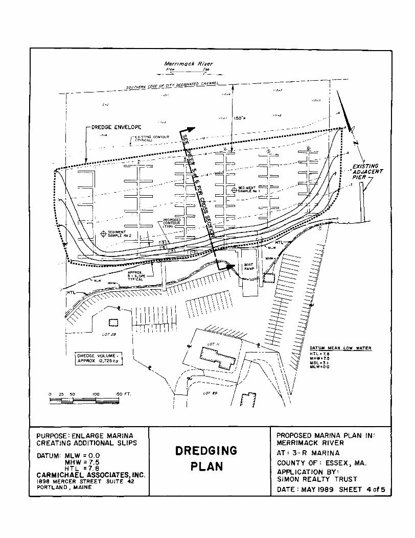
--~
SOUTffERN <:OEYF ctrr__qgt~O CH~L- -------~--------
1 -IJJt!
'
I
I LOTI/~~~ 1 'jiJ / DATUM MEAN LOW WATER
DREDGE VOLUME • I -- I HTL • 7.8
m •• , "·"''' I L ~~ ;::;;~ .:;j ::~:;} ~'"" /iill;_) j \\\\ '.\ \:v~ MLW•OO
0 25 50 100 150 FT.
PURPOSE: ENLARGE MARINA CREATING ADDITIONAL SLIPS
DATUM: MLW = 0.0 MHW = 7.5 HTL =7.8
CARMICHAEL ASSOCIATES, INC. 1898 MERCER STREET SUITE 42 PORTLAND, MAINE
\ I / --- I
11 LOT89 n \
DREDGING PLAN
PROPOSED MARINA PLAN IN: MERRIMACK RIVER
AT: 3-R MARINA
COUNTY OF: ESSEX 1 MA. APPLICATION BY: SIMON REALTY TRUST
DATE: MAY 1989 SHEET 4 of 5

20', 30• or 35' zo' or 35'
I' VARIES "'I I • VARIES
FINGER FLOAT (TYP) ~ UTILITIES
CONCRETE
.-""t::;;:t~::::::::::.~-----;n ~.,.-;;:-;-::-:-~~~ANCHOR (TYP)
TYPICAL CROSS SECTION THROUGH FINGERS
DOWELS
SOOTH
\ I \ I I I \ \
NOT TO SCALE
4°, 5' or a·
TYPICAL MARINA FLOAT NOT TO SCALE
TOfi'OP'SLDH\ [LIEY YA.RI(I
MLW•O.O
NORTH
CROSS SECTION OF DREDGED AREA
PURPOSE: ENLARGE MARINA CREATING ADDITIONAL SLIPS
DATUM: MLW = 0.0 MHW=7.5 HTL=7.8
CARMICHAEL ASSOCIATES ,INC. 1898 MERCER STREET SUITE 42 PORTLAND , MAINE
SCALE' H 1"•100' V 1"•10'
FLOAT DETAILS AND
CROSS SECTION OF
DREDGED AREA
PROPOSED MARINA PLAN IN: MERRIMACK RIVER
AT: 3-R MARINA
COUNTY OF : ESSEX , MA.
APPLICATION BY: SIMON REALTY TRUST
DATE: MAY 1989 SHEET 5of 5

APPLICATION FOR DEPARTMENT OF THE ARMY PERMIT (33 CFR 3251
OMS APPROVAL NO. 0710-003 Expires October 1996
Public reporting burden for this collection of information is estimated to overage 5 hours per response, including the time for reviewing instructions, searching existing data sources, gathering and maintaining the data needed, and completing and reviewing the collection of information. Send , ... mments regarding this burden estimate or any other aspect of this collection of information. including suggestions for reducing this burden, to Department of Defense, Washington Headquarters Service Directorate of lnformationOperations and Reports, 1215 Jeffarson Davis Highway, Suite 1204, Arlington, VA 22202-4302; and to the Office of Management and Budget, Paperwork Reduction Project 1071 0-0003), Washington, DC 20503. Please DO NO RETURN your form to either of those addresses. Completed applications must be submitted to the District Engineer having jurisdiction over the location of the proposed activity.
PRIVACY ACT STATEMENT
Authority: 33 USC 401. Section 1 0; 1413, Section 404. Principal Purpose: These laws require permits authorizing activities in, or effecting, navigable waters of the United States, the discharge of dredged or fill material into waters of the United States, and the transportation of dredged material for the purpose of dumping it Into ocean waters. Routine Uses: Information provided on this form will be used in evaluating the application for 11 permit. Disclosura: Disclosure of requested information is voluntary. It information is not provided, however, the permit application cannot be processed nor can a permit be issued.
One sat of original drawings or good reproducible copies which show the location and character of the proposed activity must be attached to this application (see sample drawings and instructions) end be submitted to the District Engineer having jurisdiction over the location of the proposed activity. An application that is not completed in full will be returned.
fiTEMS 1 THRU 4 TO BE FILLED BY THE CORPS'!
l. APPLICATION NO. 2. FIELD OFFICE CODE 3. DATE RECEIVED 4. DATE APPLICATION COMPLETED
fiTEMS BELOW TD BE FILLED BY APPLICANn
5. APPLICANT'S NAME
American Developers Associates 8. AUTHORIZED AGENT'S NAME AND TITLE l•n •v.,r is not r«tuhttl
James L. Butterfield & Assoc.
6. APPLICANT'S ADDRESS
123 Broadway Providence, RI 02909
7. APPLICANT'S PHONE NOS. W/AREA CODE
a. Residence N/ A
b. Business ( 40 l) 555-6000
11.
9. AGENT'S ADDRESS
19 Washington Street Providence, RI 02909
1 0. Ar.FNT'S PHONE NOS. WI AREA CODE
a. Residence N /A
b. Business (401) 555-5000
STATEMENT OF AUTHORIZATION
I hereby authorize, James L. Butterfield & Assoc. to act in my behalf as my agent in the processing of this application and to furnish, upon request. supplemental information in support of this permit application.
APPLICANT'S SIGNATURE
4g,.i1'1FI ATE I
NAME, LOCATION AND DESCRIPTION OF PROJECT OR ACTIVITY
12. PROJECT NAME OR TITLE 1soo instructions!
Shady Oaks Estates
13. NAME OF WA TERBODY, IF KNOWN !if •pplic•~l
Miller River 15. LOCATION OF PROJECT
Proyidence County Rhode lslapd COUNTY STATE
1 6. OTHER LOCATION DESCRIPTIONS, IF KNOWN, ,,..ln.rructioll81
17. DIRECTIONS TO THE SITE
14. PROJECT STREET ADDRESS !if •JJP/k4"'-1
Hines Road, Cumberland
Take 295 to Route 114 South - Go 1/2 mile then bear left onto Bear Hill Road. Take right onto Hines Street. Follow for One mile. Look for dirt road on left.
ENG FORM 4345. Feb 94 EDITION OF SEP 91 IS OBSOLETE. (Proponent: eEeW-oAI

1 8. Nature of Activity (Descriprion of project, include all features/
Discharge fill material for three subdivision roadway crossings: 1. Approximately 100' x 30' in wetland crossing A at Acadia Drive (Sheet 4 of 9). 2. Approximately 120' x 60' in wetland crossing B and Miller River at Katahdin Dr.
(Sheet 5 of 9). 3. Approximately 120' x 60 1 in wetland crossing C and Miller River, including box
culyert at Acadia Driye (Sheet 7 of 9), 1 9. Project Purpose !Describe the reason or purpose of the project, see instructions)
Shady Oaks Estates multiple lot residential subdivision. All lots to be developed on upland. Construction is expected to begin April 1988 and take approximately one year to complete.
USE BLOCKS 20-22 IF QREDGED ANDIOR FILL MATERIAL IS TO BE DISCHARGED
20. Reason{s) for Discharge
21.
The placement of fill is necessary to construct subdivision roadways across wetlands/waterways.
Ty[?e{sl of Material Being Discharged and the Amount of Each Type in Cubic Yards Clean granular fill material, trucked in, and placed by dozer, front and loader and grader: 1. 300 CY in Wetland A. 3. 3,000 CY in Wetland C; 20 CY below OHW of Miller River. 2. 760 CY in Wetland B; 15 CY below OHW of Miller River.
22. Surface Area in Acres of Wetlands or Other Waters Filled /see instructions)
1. 2,800 SF Wetland A 2 .. 3;6t)()' SF Wetla~d B~ (42o SF··. below OHW of Miller River) 3. 6~600 SF Wetland 6 (800 SF below OHW of Miller River)
23. Is Any Portion of the Work Already Complete? Yes - No ..,X_ IF YES, DESCRIBE THE COMPLETED WORK
24. Addresses of Adjoining Property Owners, Lessees, Etc., Whose Property Adjoins the Waterbody {If more than can be entered here, please attach a supplemental list).
See attached sheet.
25. List of Other Certifications or Approvals(Denials Received from other Federal, State or Local Agencies for Work Described in This Appliea'tion.
AGENCY
Planning Board Zoning Board RI - DEP
TYPE APPROVAL • IDENTIFICATION NUMBER
Sub-Division Approval -Site Plan Review Wetland Permit File #6682
•would include but is not restricted to zoning, building and flood plain permits
DATE APPLIED
Sept. 1986 Sept. 1986 Aug. 1987
DATE APPROVED
June 1987 June 1987 Pending
DATE DENIED
26. Application is hereby made fo_r a permit or permits to authorize the work described in this application. I certify that the information in this application is complete and accurate. I further certify that I possess the authority to undertake the work described herein or acting as the
duly al;t:J[,:he::~ LATE J'-1 I ffir! ~IJili.J st,~"l SIGNATURE OF APPLICANT ~ SIGNATURE OF AGENT f DATE
The application must be signed by the person who desires to undertake the proposed activity (applicant) or it may be signed by a duly authorized agent if the statement in block 11 has been filled out and signed.
18 U.S.C. Section 1001 provides that: Whoever, in any manner within the jurisdiction of any department or agency of the United States knowingly and willfully falsifies, conceals, or covers up any trick, scheme, or disguises a material fact or makes any false, fictitious or fraudulent statements or representations or makes or uses any false writing or document knowing same to contain any false, fictitious or fraudulent statements or entry, shall be fined not more than $10,000 or imprisoned not more than five years or both.
• U.S.GPO: 1 994·520·4 78/8201 8

I. VICINITY MAP I INDEX 2. EXISTING SITE CONDITIONS 3. PROPOSED SITE CONDITIONS/
SHEET LAYOUT 4. WETLANDS PLAN/CROSS·SECTION 5. WETLANDS PLAN 6. WETLANDS CROSS-SECTIONS 1. WETLANDS PLAN 8. WETLANDS CROSS-SECTIONS 9. CONSTRUCTION DETAIL I
EROSION CONTROL
•THESE PlANS COURTESY OF VANASSE HANGEN BRUSTLIN, INC.
···"'""
VICINTY MAP U.S.O.S. PAWTUCKET QUADRANGLE
tooo 2000 o 'IF SCALE IN FEET
DATI!
AUGUST 14, 1e87
cB JemH L Butterfield a Aeeoo. ConaMII El ........ A............ IHEET OF Provldeuo., Rhode ..._. 01801 AT: CUIIBI!IILAND AJIIILtCATION av:
1 g
SHADY OAKS ESTATES VICINITY MAP/INDEX
4011885-1000 IN: MLLI!IIIIIIMII AMERICAN CEVB..OPERS A880CIATES "'OvmNCI! COUNTY tTATR 01' 11H001! IILANO

tB J.,.• L. Butterfield & Aaaoc. CGMUM~g E..,.... a P~Mwwa PrcwldenM, Rf1ocM lalend 02800 401/511-5000
AT:CUMaEIILANO IN: IIILUIIS IIIVEII PIIOYIDeNCI COUNTY STATE OF IIHOOIISLAND
lt!Ul.l.• I. EDG£ OF WETLAND IIEPRUENTS EXTENT OF
WETLAND SUBJECT TO FEOEIIAL JURISDICTION
500
SCALE IN FEET
SHADY OAKS ESTATES EXISTING SITE CONDITIONS
APPLICATION BY:
2. NO FLOODWAY PUBLISHED
AMERICAN DEVELOPERS ASSOCIATES
DATE
AUGUST 14, 1187
SHI!ET OF
2 9

J8 'i'fAD1 ." I k~ Nlf J I ~ PAOPOifY INC
"'""'~.€lit-.
COMPENSATORY r=t/J ~ IIACk~IIIC.
cB
F1..00D STtftAOE AREA
IUlNEYi.I·TRICE M .mENt'casra
J81M• L Butterfield a A••oo. c~~IPIII••• ~Rhode ........ 02801 4011551-1000
HIF WIUIAMY aMILOM:D
IJNOL()W •
1100 ZIIO 0 1100
ICALI II I'IET
SHADY OAKS ESTATES PROPOSED Slrt CONDITlONS/SHEET LAYOUT
AT:C~ lt~fiVER l'tiOYIOINCI COUNTY aT ATE OF lltOIIE I8UHO
APPUCAnON aY:
AMERICAN DEVB...OPER8 A880CIATES
DATE
AUGUST 14, 1187
ltR1' 01'
3 9

tB
, I I I I
8! /
I I I
----, - I
I (J)\
~I -I ::1:1
170
\ \
\ I I I
~ ~ ~
\
~ \ \ '-
.J
.J u: LL 0 1--:i :;
~ ~~. 0
..._
' '-
PROPOSED GRADE
2
~v
" "'
\
/"" I \
\.
lfP -·------ """-// J ' PLAN
'19 40 0 so
~-··
0
.J
.J~
SCALE IN fEET
3o.o· j-l -3·· BIT CONC
12" GRAVEL BORROW
\_ORDINARY BORROW\
/- ' ( ' '\.
J ' "-.. --- ---,.,0 -- I \ I \.._ I I
' WETLAND CROSSING AREA A
AREA OF w~ft~=~rL ;~t'AAA~ F~Hl (CUBIC YARDS)
2100 aoo
LEGEND
c::J AREA OF WETLAND FILL
~WETLAND
LOAM8 SEED
.J
.J u: IL 0
t:: ::1! ::J
EROSION CONTROL
~ EXISTIN3 GROll NO \
- - - _-L -- ..l£_ - - -- -t:::_ ~ L J ~
165
Jeme• L Butterfield A Aeeoc. COitiUM1g E,._.,. & ,..,.._. Providence, Rhode ,...... onot 4011555-5000
AT:C~ERLAND IN; MILLERS RIVER PROV~NCI! COUNTY STATE OF RHOOI! ISLAND
.SECTION A-A SCALE · HORIZ · , ••• a•
VERT · I"• 4"
SHADY OAKS ESTATES WEtLANDS PLAN/CROSS SECTION
APPLICATION BY:
N.ER1CAN DEVB..OPERS ASSOCIA ~8
DATE
AUGUST 14, 1887
SHEET OF
4 9

~.,
\ 100-'I'EAR I .. LOODPLAIN
I l
"---
DRIVE
81
PLAN eo 40 0 60
SCALE IN FEET
;· r- ---165
\ "'-'-
~ \
~
I I
LEGEND
E:J AREA OF WETLAND FILL
~WETLAND
DATE
C~ EJ91e ... a.,...,.,.. WETLANDS PLAN AUGUST 14, 11187 cB Jemee L. Butterfield & Aeeoc. .SHADY OAKS ESTATES
Prcmdenc .. Rhode ....... 02108 AT: CUMBERLAND 401/111-5000 IN: MILLI!III IIIVI!R APPLICATION BY: SHEET
PIIDYIDENCE COUNTY AMERICAN DEVELOPER8 A880CIATE8
OF
5 9 STATE OF RHODE ISLAND

165.0-
1600-
150.0-
170.0-
160.0-
"!'~ _RIVER 40.0' R.O.W. MILLERS
"·'' ,. "' -I ::l li:
!5 1-i ::J
12"GRAVEL EIORROW
l ORDINARY BORROW l
I <t ... :r
.J
.J ;;::
~I 1.....-PROP I~ GRADE ::J
RIVER
.,.,.~ ~ r,., ... ,~~~~L"'"""" ~ ~A::wss::e; ---- --
6"-12' STOl-E '=-=:ExCAWio;-WCRu::EOSTONEL 6"-12' STONE PROTECTION BEDDING LIMIT Of PROTECTION
SECTION 8-8 EXCAVATION
SCALE • HORIZ. • 1'•20' VERT • I'• 8'
~ "' ~ ~ ~ .J
~ a: ~ ~ ~ ~ t: ~ 1-
:::E • !f -, ::J [3 BIT CONC. 1 ;! PROP. GRADEl I ~I .J
I L,2" GRA~EL BORROw!
....,!!!9 Ylt CoROINARY I EXIST GROUN07
FLOOD _:LEVATION •1570 90RROW_/ __) .---- .---------
l!lO.O-
tB
- -- i BOX CULVE~R, -.----
----~ ~ ~ -- _..._ - -----J ___J ...- :...------ - Llt.IIT Of EXCAVATION
g;~5/l&oiNG
J..,.• 1.. Butterfield a Aeeoc. C_.._ Engineer• a .......... Providence. Rhode IIIMd 02808 401/555-5000
AT: CUMBERLAND IN: MILLERS IIIVEit PROVIDENCE COUNTY STATE OF RHOOE ISLAND
SECTION C-C SCALE • HORIZ • 1"•29'
VERT.· I'• 8
SHADY OAKS ESTATES WETLANDS CROSs-SECtiONS
APPLICATION IY:
MERICAN DEVB..OPER8 A880CIATE8'
DATE
AUGUST 14, 1t87
SHEET OF
6 9

~.t"-"'--,
~-
~ (~--~1
)
I 100-YEAR FLOODPLAIN ,_
LEGEND
G.J AREA OF WETLAND FILL
ei3 WETLAND
~ 0 ~ 0
t} ~(~~ t"\ I ) <-
/ / II I
J- ... - ( I ';, /" • I I . .~ it- I r 1 •• 1 :1; T I
;R~~(_) I )
I '( , I I I \ ( I I(!'\) --_./
I I I I /r
/
I I /
J, / }/(/ ~ ~ ; ~ ~
~
PLAN ao 40 o eo
SCALE IN FEET
DATE
cB J_,.• L. Butterfield a Aeeoo. SHADY OAKS ESTATES ConM!IIntl Er1gNen I.,..,._. WETLANDS PLAN AUOUST 14, 1887
ProwldeiiC .. Rhode ...... 02808 17,~;;;;;::-;;:----------,r:::::::==----------b----~-~J 401/551HIOOO ~~~-..~~::: AH'UCATIOft av: aNEET
PROVIDeNCI COUNTY
Of'
7 9 aT ATE Of' RHOOIIILANO

11'0-
165
160
155
~
145
170
16!1
160
155
150
145.J
MILLERS RIVER
~ ~
!
..J
I ~ 2
•G
YJo'
I L3"BIT~ I f 12" GMIEL r fiORRoW f
LORDNARY BORROW7 ,
PROPOSED ~~ GRAD~ ~ 2 ~ I•
..J .J U,.i
~·
~
MILLERS RIVER
FLOW
"'"'"" ..... , ' ~~ -..11.2HW. 146.!1 ____ \__ I [1 2.0'a5.0' BOX CULVERT 1 I - --- 6"_;-::-:; qli'"+CF* ==;g:?tt~.-;ONE~~C~-
PROTECTION SCALE •IOIZ, I'•20' BEDDING - ---- \_LIMIT a; EXCAVATION
~,~ jl:; ::;J
VERT. • I"• 10' 1§1
(I)~ ~c( "' !:: r:! PROPOSED j ~~ GRADE
( 3" BIT CONC. ; -12" GRAVEL BORROW
' 6 ~ ru'"''"
lORDLRY BORROW
100 YR FLOOD I!:LIVATION ) -- •149.0 ( ~ -- -- - -- iL_ _. £_ ~BOX CUL~ _[ ~~"tG -~ ~ ..Jt . -- .-11. ------------- 1--- - --
SECTION F-F SCALE· HORIZ• 1"•20'
VERT , 1"• IO'
tB JMMe L Butterfield & Aeeoc. COMIMtill__.& .......... ,..,.....,.. Rhode ....... 02808 4011188-1000
AT: CUMBERLAND IN: MILLERS IIIIIVER PROVIDENCE COUNTY STATE OF RHODE ISLAND
SHAbY OAKS ESTAn:S WETLANDS CROSs-SECTIONS
APPLICATION IY:
AMERICAN CEVELOPERS A880CIATEI
-
-----------· ---- ----------
I!ATE
AUGUST 14, 1187
SHEET OF
8 ·9

cB
NOT£ HCS 0£TA!l 15 TY?JfAt AT ~0,.H THE ACM'JJ.A [)RJ'IE AND K.AlA~OJN
OR:VE CROSSINGS Of Mit ( rR~ RlV(~.
I" -:J~ \
.=.:~ .
·,.c\ \ ) )
DR IV£
;·
··-
~w PLAN
SCALE•1 11•40'
COr.tSHtUCTION PROCEDURES
I. INSTALL TYPE C EROSlON CONTROL AS >•OWN.
1. EXCAVATE TRENC" FOR TEMPORARY CI'IVERT.
3. INSTALL TEMPORARY 36 INCH DIAMETER CulVERT. MA•CH PROPOSED INVE•l ELEVATIONS WIT• EXISTING FLOW LIHE Of MILLERS R:VER.
4. INSTAll JERSEY BARRIERS AND ~AN~ BAGS AS SHOWN.
1. PUMP AREA BfHIND JERSEY BARRIERS TO PROVIO£ DRY WORK AREA.
6. CONSTRUCT HEADWALLS, BOX CULVERTS, STONE PROTECTl.JN, ANC ROAOWP."fS AS SHOWN ON THE PL ANI •
7. REMOVE JERSEY BARPIERS AND SAND BAGS.
8. cUT BACK Tli!PORARY CULVfRT INTO 510[ SLOPES SO [NT IRE CUL V[RT II BURIED.
9. !NSTJ\LL TVP( C [;l:()SJON !ONTIWt TO EDGE OF HEADWALL':..
-----SAND BAGS AT JOINTS
r-----JERSEY BARRIER
SECTION A-A l NOT TO SCALEJ
TYPE 'c'
BOTTOM OF RIVER BED
EROSION CONTROL DETAIL NOT TO SCALE
DATE
J.mee L Butterfield & Aeeoc. c~~·,...._. ProWieNie, Rhode ...... 02808 40111111-1000
SHADY OAKS ESTATES CONSTRUCTION DETAIL/EROSION CONTROL
AUGUST 14, 11~87
SHEET OF AT: CUMBERLAND I APPUCATION •v: IN: MILLERS RIVER PRoviDENcE couNTY AMERICAN DEVELOPERs A880CIA TEa 9 9 STATE OF ltHOD~ ISLAND

APPLICATION FOR DEPARTMENT OF THE ARMY PERMIT (33 CFR325J
OMB APPROVAL NO. 0710.003 Expires October 1998
Public reporting burden for this colection of information is estimated to average 5 hours per rnponse. including the time for reviewing instructions. searching existing data sources, gathering and maintaining the data needed, and completing and reviewing the coUectlon of information. Sand ~ .. mments regarding this burden estimate or any othef aspect of this collection of information, including suggestions for reducing this burden, to Department of Defense, Washington Headquarters Service Directorate of lnformationOperations and Reports, 1215 Jefferson Davis Highway. Suite 1204. Arlington, VA 22202-4302; and to the Office of Management and Budget. Paperwork Reduction Project (071 0-00031. Washington, DC 20503. Please DO NO RETURN your form to either of those addresses. Completed applications must be submitted to the District Engineer having jurisdiction over the location of the proposed activity.
PRIVACY ACT STATEMENT
Authority: 33 USC 401, Section 10; 1413, Section 404. Principal Purpose: These laws require permits authorizing activities In, or affecting, navigable waters of the United States, the discharge of dredged or fill materiel into watert of the United States, and the transportation of dredged material for the purpose of dumping it Into ocean waters. Routine Usea: Information provided on this form wiU be uaed In evaluating the application for a permit. Disclosure: Discloaura of requested Information Is voluntary. If information is not provided, however, the permit application cannot be processed nor can a permit be iuued.
One set of original drawings or good reproducible copiea which show the location and character of the proposed activity must be attached to this application (sH aample drawing• and inatructions) and be submitted to the District Engineer having jurisdiction over the location of the proposed activity. An application that ia not completed in full wiU be returned.
'"~MS 1 THRU 4 TO B~ FILLED BY THE CORf>Sl_
1 . APPLICATION NO. 2. FIELD OFFICE CODE 3. DATE RECEIVED 4. DATE APPLICATION COMPLETED
(ITEM$ BELOW TO BE FILLED BY APPLICAN_Il
5. APPLICANT'S NAME
Lexi S. Scott 8. AUTHORIZED AGENT'S NAME AND TITLE f•uSI.->t is norr.,.Wodl
WVE Engineering Associates
6. APPLICANT'S ADDRESS
246 Eighth Avenue Falmouth, MA 02256
7 APPLICANT'S PHONE NOS. W/AREA CODE
a. Residence (508) 555-3412
b. Business N I A
]1.
9. AGENT'S ADDRESS
1011 Harrison Avenue Northhampton, MA 01036
10. AGENT'S PHONE NOS. W/AREA CODE
a. Residence N I A
b. Business (413) 555-9876
STATEMENT OF AUTHORIZATION
I hereby authorize, WVE Engineering Associates to act in my behalf as my agent in the processing of this application and to furnish, upon request, supplemental information in suppon of this permit application.
NAME. LOCATION AND DESCRIPTION OF PROJECT OR ACTIVITY
12. PROJECT NAME OR TITLE l••• in•truction•J
Lexi S. Scott
13. NAME OF WA TERBODY, IF KNOWN r;r •pplic•~HJ
Childs River
15. LOCATION OF PROJECT
Barnstable County COUNTY
Massachusetts STATE
16. OTHER LOCATION DESCRIPTIONS, IF KNOWN, tu.;nstructi<JmsJ
17. DIRECTIONS TO THE SITE
14. PROJECT STREET ADDRESS lifopplico~JMJ
246 8th Avenue Falmouth, MA 02256
From Waltham, MA take 95 South to Route 24 South to Route 495 South over the Bourne Bridge (Note 495 turns into Route 25 before crossing the Bourne Bridge). Follow 28 South into East Falmouth. Continue through East Falmouth Center then take a right onto Seacoast Shores Blvd. Take a left onto Eighth Avenue. Last house on the left.
ENG FOAM 4345. Feb 94 EDITION OF SEP 91 IS OBSOLETE. (Proponent: c£cW·OR.

1 8. Nature of Activity (Descript;,n ol proj«t. include 1111/Htur••l
The applicant proposes to remove an existing pier and float, and construct an 85 ft. timber bulkhead, a 4' x 72' pile-held timber pier, a 4' x 16' timber ell, an 8' x 16' timber float and 2 timber dolphins. Construction of the bulkhead requires filling approximately a 10' x 26' area below the High Tide Line (HTL).
19. Project Purpose tO.xril» ,,. rNSon 01 purpou of,,. pro;.<t • ... instnletion$1
The purpose of the proposed activity is to provide recreational boating for the applicant to access the Childs River. Construction is expected to begin this spring and take two months to complete.
USE BLOCKS 29-22 If DREDGED AND/OR FILL MATERIAL IS TO BE DISCHARGED
20. Reason(s) for Discharge
The proposed bulkhead alignment properties. Fill material will to the shoreline. Fill will be
is needed to tie into the existing bulkheads on abutting be trucked to the site and stockpiled on uplands adjacent placed behind the bulkhead by a small, rubber tire front-end
21. Type(s) of Material Being Discharged and the Amount of Each Type in Cubic Yards loader.
A total of 200 CY of clean granular fill will be used to backfill the timber bulkhead.
22. Surface Area in Acres of Wetlands or Other Waters Filled t ... instructionsl
260 s,f. of waterway will be filled
23. Is Any Portion of the Work Already Complete? Yes -- No -- IF YES, DESCRIBE THE COMPLETED WORK
Existing pier and float are in place. Proposed to be removed.
24. Addresses of Adjoining Property Owners. Lessees, Etc., Whose Property Adjoins the Waterbody (If more than can be entered here, please anach a supplemental list).
East: Walter G. & Helen J. Rundle 248 8th Avenue Falmouth, MA 02256
West: John J. & Janet H. Caldwell 244 8th Avenue Falmouth, MA 02256
25. List of Other Certifications or Approvals/Denials Received from other Federal, State or Local Agencies for Work Described in This Application.
AGENCY Conservation Com. MA DEP Waterways Program
TYPE APPROVAL • IDENTIFICATION NUMBER Order of Condition SEl-476 Waterways License 89-2165
DATE APPLIED DATE APPROVED DATE DENIED Sept. 1, 1988 Dec. 14 1988
Jan. 1989 Pending
"Would include but is not restricted to zoning, building and flood plain permits
26. Application is hereby made fo_r a permit or permits to authorize the work described in this application. I certify that the information in this application is complete and accurate. I further certify that I possess the authority to undertake the work described herein or am acting as the duly authorized agent of the applicant. / J
lJ. v. a J..&Mb e c. !f.!~' SIGNATURE OF APPLICANT DATE SIGNATURE OF AGEN~ DATE
The application must be signed by the person who desires to undertake the proposed activity (applicant! or it may be signed by a duly authorized agent if the statement in block 11 has been filled out and signed.
18 U.S.C. Section 1001 provides that: Whoever. in any manner within the jurisdiction of any department or agency of the United States knowingly and willfully falsifies, conceals, or covers up any trick, scheme, or disguises a material fact or makes any false, fictitious or fraudulent statements or representations or makes or uses any false writing or document knowing same to contain any false, fictitious or fraudulent statements or entry, shall be fined not more than $10,009 or imprisoned not more than five years or both.
•u.S.GPO: 1994·520-4 78182018

SOURCE: U.S.G.S. QUADRANGLE I: 25000
PURPOSE: REPLACE EXISTING TIMBER PIER
DATUM: MLW=O.O MHW = 1.9 HTL = 2.3
WVE ENGINEERING ASSOCIATES 1011 HARRISON AVENUE NORTHAMPTON, MA.
VICINITY MAP
APPLICATION BY: LEXI S. SCOTT 246 8TH AVENUE FALMOUTH,MASSACHUSETTS
PROPOSED TIMBER PIER, FLOAT, GANGWAY, ELL, DOLPHIN PILES AND BULKHEAD IN: CHILDS RIVER AT: FALMOUTH, BARNSTABLE CO.,
MASSACHUSETTS
DATE : JAN. 1989 SHEET I of 4

~· ~JI.·
CHILDS RIVER
301
1.0 EXIST.
.!! 'l nMBER WALK , ,
1 IS't ,// a: f'w1DE: /I
PATM--+/ -; 'I
u..i ', : :
I I ........ If
z::Z:: I: .., r r
cj I I r r l1 ... 0 I • I I
~ ! ~ I I
~ BENCH tt4~K CHISEL
1
a' SET EL.20.04
LOT 6
ll
PURPOSE: REPLACE EXISTING TIMBER PIER
DATUM: MLW =0.0 MHW = 1.9 HTL =2.3
WVE ENGINEERING ASSOCIATES 1011 HARRISON AVENUE NORTHAMPTON , MA.
PROP. 4xl61
nMBER ELL
-'~
PROP. BULKHEAD
... • "0
8 x u..-,.
z:i .., t ..,
ai .!
LOT 7 ~
LOTS
PLAN VIEW
APPLICATION BY: LEXI S. SCOTT
I. ELEVATIONS ARE IN FEET a TENlHS BASEDON THEPLANEOFMEAN LDW WATER. MJMJS FIGURES REPRESENT ELEVATIONS BEJ.DWlHAT SAME PLANE.
2. 11MBER PILES 10 BE CCA TREATED AT2.5 PCF. ALL OTHER 11MBERTO BE CCA TNEATED AT 1.0 PCF.
3. PROJECT LOCATED IN 100 YR. FLOOD PLAIN ,_EL.= II NGVD, FALMOUTH FIKM 5/15/86.
0 S 10 20 30 4S 60 FEET
EH~Ii:J~~iiiiiil~~=~'
PROPOSED TIMBER PIER,_ FLOAT, GANGWAY, ELL, DOLPHIN I"'ILES AND BULKHEAD
IN: CHILDS RIVER AT: FALMOUTH L.BARNSTABLE CO.,
MASSACHU~ETTS
246 8TH AVENUE FALMOUTH , MASSACHUSETTS DATE: JAN. 1989 SHEET 2 of 4

z"•4" HANDRAil..
., N
., N
87'-o"
7 BENTS AT 12-0 O.C. =72
Ill)
N
TIMBER PIER PROFILE SCALE 1": 15'-o"
'""! ·----------12·-o··:..... -----------~·~r I 2"x4" HANDRAIL
LONGITUDINAL GANGNAY SECTION SCALE 3/8"= 1'-0"
4"x4" POSTS
1!1'- o·
PROP. 4'al8' TIMBER El..l..
HTI.. EL Z.3 MHW EL 1.9
ELW. - 0. !I MLW EL 0,0
-~;;t~- -----., N ~GROUND ~
~ 0
PROP. DOLPHIN :.LES ( 2 REQD.)
PROP. FLOAT PILES ( 2 REQD.I
2"x4" HANDRAIL
3/8"(/J GAL\1.
~~~~~~~--BOLTS
GANGWAY SECTION SCALE 3/8"=1' -0"
HANDRAIL t2"x4") ONE SIDE ONLY
3"x8" STRINGERS r+-+- 2" DECK W/1" SP.
F;::t::::c:c::::t::I:!:#=z::::I::J=:::~::::t:::t::I::Gi.,. 2'x 8" FRAME
---1---14" GAL\l "'-7.q........:+-3"xe" SPLITCAP
2"x6"SI<IO
10"x20" CONTINUOUS STYROFOAM
TIMBER FLOAT SECTION SCALE 1/4"=1'-0"
PURPOSE: REPLACE EXISTING TIMBER PIER
DATUM: MLW = 0.0 MHW= 1.9 HTL = 2.3
WVE ENGINEERING ASSOCIATES 1011 HARRISON AVENUE NORTHAMPTON 1 MA.
BOLTS
BENT SECTION SCALE 1/4' = 1'-0"
PIER AND GANGWAY DETAILS
APPLICATION BY: LEXI S. SCOTT 246 8TH AVENUE FALMOUTH , MASSACHUSETTS
HTL EL. 2.3 MHW EL. 1.9
MLW EL.O.O ELW EL,-0,5
PROPOSED TIMBER PIER, FLOAT, GANGWAY, ELL, DOLPHIN PILES AND BULKHEAD
IN: CHILDS RIVER AT: FALMOUTH, BARNSTABLE CO.,
MASSACHUSETTS
DATE: JAN. 1989 SHEET 3 of 4

FILL AREA VARIES FROM 1' T04'------.
75 CY OF FILL BELOW HTt.
~-2''xa" WALES 2-0UTSIDE
:\:=;;::::;r==~~~;;<~~~~FPf- _1_-IN_SID_E, TOP.!_ BOTTO_M HTL+ 2_3,
DEAD UAN PILE 8"11
QJ x8'---;-
NOTE:
2"x 10" TONGUE a GROOVE SHEET PILING (10' LENGTHS)
-----~EXISTING GRADE --16' ----. ·- · ·- · · -· ·-··-· ·MLW 0.00
-+-r-- a" I& PILINGS ON 6' CENTERS 6" POINT 7" TO 9" ON BUTT
I) ALL TIMBER (INCLUDING PIER) PRESSURE a CHEMICAL TREATED.
2) ALL HARDWARE (INCLUDING PIER) HOT DIPPED GALVANIZED.
3) BULKHEAD TO BE PLACED BEHIND FRINGE WETLANDS
4) APPROX. 200 CU. YDS. OF CLEAN FILL.
PURPOSE: REPLACE EXISTING TIMBER PIER
DATUM: MLW=O.O MHW: 1.9 HTL =2.3
WVE ENGINEERING ASSOCIATES 1011 HARRISON AVENUE NORTHAMPTON, MA.
SECTION A-A NOT TO SCALE
CONSTRUCTION DETAIL/ SECTION VIEW OF PROPOSED BULKHEAD
APPLICATION BY: LEXI S. SCOTT 246 8TH AVENUE FALMOUTH, MASSACHUSETTS
PROPOSED TIMBER PIER, FLOAT, GANGWAY ,ELL, DOLPHIN PILES AND BULKHEAD
IN: CHILDS RIVER AT: FALMOUTH, BARNSTABLE CO.,
MASSACHUSETTS
DATE: JAN. 1989 SHEET 4 of 4

APPLICATION FOR DEPARTMENT OF THE ARMY PERMIT (33 CFR 325)
OMB APPROVAL NO. 0710-0003 Expires June 30, 2000
The Public burden for this collection of information is sestimated to average 10 hours per response, although the majority of applications should require 5 hours or less. This includes the time for reviewing instructions, searching existing data sources, gathering and maintaining the data needed, and completing and reviewing the collection of information. Send comments regarding this burden estimate or any other aspect of this collection of information, including suggestions for reducing this burden, to Department of Defense, Washington Headquarters Service Directorate of Information Operations and Reports, 1215 Jefferson Davis Highway, Suite 1204, Arlington, VA 22202-4302; and to the Office of Management and Budget, Paperwork Reduction Project (0710-0003), Washington, DC 20503. Respondents should be aware that notwithstanding any other provision of law, no person shall be subject to any penalty for failing to comply with a collection of information if it does not display a currently valid OMB control number. Please DO NOT RETURN your form to either of those addresses. Completed applications must be submitted to the District Engineer having jurisdiction over the location of the proposed activity.
PRIVACY ACT STATEMENT
Authorities: Rivers and Harbors Act, Section 10, 33 USC 403; Clean Water Act, Section 404, 33 USC 1344; Marine Protection, Research and Sanctuaries Act, 33 USC 1413, Section 103. Principal Purpose: Information provided on this form will be used in evaluating the application for a permit. Routine Uses: This information may be shared with the Department of Justice and other federal, state, and local government agencies. Submission of requested information is voluntary, however, if information is not provided the permit application cannot be evaluated nor can a permit be issued. One set of original drawings or good reproducible copies which show the location and character of the proposed activity must be attached to this application (see sample drawings and instructions) and be submitted to the District Engineer having jurisdiction over the location of the proposed activity. An application that is not completed in full will be returned.
(ITEMS 1 THRU 4 TO BE FILLED BY THE CORPS)
1. APPLICATION NO. 2. FIELD OFFICE CODE 3. DATE RECEIVED 4. DATE APPLICATION COMPLETED
(ITEMS BELOW TO BE FILLED BY APPLICANn
5. APPLICANT'S NAME 8. AUTHORIZED AGENT'S NAME AND TITLE ran agent is notrequiredl
6. APPLICANT'S ADDRESS 9. AGENT'S ADDRESS
7. APPLICANT'S PHONE NOS. W/AREA CODE 10. AGENT'S PHONE NOS. W/AREA CODE
a. Residence a. Residence
b. Business b. Business
11. STATEMENT OF AUTHORIZATION
I hereby authorize, to act in my behalf as my agent in the processing of this application and to
furnish, upon request, supplemental information in support of this permit application.
APPLICANT'S SIGNATURE DATE
NAME, LOCATION AND DESCRIPTION OF PROJECT OR ACTIVITY
12. PROJECT NAME OR TITLE !see instructions!
13. NAME OF WATERBODY, IF KNOWN iif~>pplic~biel 14. PROJECT STREET ADDRESS !if ~pphcl>hlei
15. LOCATION OF PROJECT
COUNTY STATE
16. OTHER LOCATION DESCRIPTIONS, IF KNOWN, lsee instructions!
17. DIRECTIONS TO THE SITE
ENG FORM 4345, Jut 97 EDITION OF FEB 94 IS OBSOLETE. {Proponent: CECW-OR)

18. Nature of Activity (Description of project, include a11 features)
19. Project Purpose (Describe the reason or purpose of the project, see instructions)
USE BLOCKS 20-221F DREDGED AND/OR FILL MATERIAL IS TO BE DISCHARGED
20. Reason(s) for Discharge
21 . Type(s) of Material Being Discharged and the Amount of Each Type in Cubic Yards
22. Surface Area in Acres of Wetlands or Other Waters Filled !see instructions!
23. Is Any Portion of the Work Already Complete? Yes __ No __ IF YES, DESCRIBE THE COMPLETED WORK
24. Addresses of Adjoining Property Owners, Lessees, Etc., Whose Property Adjoins the Waterbody (If more than can be entered here, please attach a supplemental list).
25. List of Other Certifications or Approvals/Denials Received from other Federal, State or Local Agencies for Work Described in This Application.
AGENCY TYPE APPROVAL' IDENTIFICATION NUMBER DATE APPLIED DATE APPROVED DATE DENIED
'Would include but is not restricted to zoning, building and flood plain permits
26. Application is hereby made for a permit or permits to authorize the work described in this application. I certify that the information in this application is complete and accurate. I further certify that I possess the authority to undertake the work described herein or am acting as the duly authorized agent of the applicant.
SIGNATURE OF APPLICANT DATE SIGNATURE OF AGENT DATE
The application must be signed by the person who desires to undertake the proposed activity (applicant) or it may be signed by a duly authorized agent if the statement in block 11 has been filled out and signed.
18 U.S.C. Section 1001 provides that: Whoever, in any manner within the jurisdiction of any department or agency of the United States knowingly and willfully falsifies, conceals, or covers up any trick, scheme, or disguises a material fact or makes any false, fictitious or
fraudulent statements or representations or makes or uses any false writing or document knowing same to contain any false, fictitious or fraudulent statements or entry, shall be fined not more than $10,000 or imprisoned not more than five years or both.

19
Additional Guidance for Section 404 Permit Applicants Wetland Delineation Applicants should contact the Corps early in the project planning stage for delineation requirements. It is often beneficial to work your local, state, and federal permit applications concurrently to avoid duplication of effort and time delays. The Corps does not require final design information. The applicant or the applicant's consultant should check with Corps if any of the procedures described are not understood from pre-application meetings. • Prepare a surveyed site plan of property with existing
contours. • Stake out a field delineation of waters and wetlands
subject to Corps jurisdiction as defined in Corps permit regulations published in the November 13, 1986 Federal Register and the criteria identified in the current accepted Corps Manual for identifying and delineating jurisdictional wetlands.
• Plot the limits of these waters and wetlands on surveyed site plan.
• Have Corps staff field check these jurisdictional limits as necessary.
• On the site plan, which now shows the limits of waters and wetlands, draw the footprint of the entire project. Include buildings, roadways, parking areas etc., and limits of all fill to be placed in waters and wetlands.
• New England District Wetland Delineation Data sheets should be submitted to support the limits of wetlands.
Values Assessment During the field delineation, the applicant should gather preliminary data to support an estimate of the functions and values of the waters and wetlands which are likely to be impacted by the project. Primary functions and values for wetlands are: - Groundwater recharge/discharge - Flood flow alteration - Fish and shellfish habitat - Sediment/toxicant retention - Nutrient removal - Production export - Sediment and shoreline stabilization - Wildlife habitat - Recreation - Educational scientific value - Uniqueness/heritage - Visual Quality/Aesthetics - Endangered species
For each affected wetland, an evaluation should be prepared addressing at least these wetland functions and values. Others may be included based on professional judgement. Several protocols for estimating wetlands functions have been published and are in use. However, the New England Division requires a descriptive approach where the applicant determines the functions and values provided by each wetland. In consultation with the Corps and the resource agencies, the applicant determines the principal functions and values of the wetland and describes the rationale behind that decision. Corps confidence in the valuation is based upon the strength and accuracy of the supporting information. This descriptive approach is described in the New England Division’s Highway Methodology Supplement Workbook entitled, “Wetland Functions and Values, A Descriptive Approach". Using this information, the Corps will estimate the potential for individual and cumulative impacts to each wetland function and value. For projects where mitigation is proposed or likely, the applicant should refer to the New England District’s Mitigation Checklist. This checklist will guide the applicant and consultants in developing complete mitigation plans. The requirements for clarity are similar to those for project plans. However, there are additional details that are specific to mitigation which must be added. Alternatives Analysis The Corps must determine the "basic project purpose" after which the applicant must analyze practicable alternatives to avoid filling waters and wetlands. For individual permits, subject to public notice, the Corps uses a sequential approach of first analyzing off site alternatives. Second, we look at on-site project modification to avoid and minimize wetland impacts. Third, we consider compensatory mitigation to replace the functions and values of wetlands unavoidably impacted. In this way the Corps follows the following sequencing to minimize impacts to wetlands: avoid, minimize, compensate. Note that for non-water dependent projects, there is a presumption in the 404(b)(1) guidelines that practicable alternatives are available that do not involve filling wetlands and other special aquatic sites. Unless the applicant can rebut this presumption, a permit for non-water dependant fills cannot be issued. Project modification to avoid unnecessary wetland filling may result in reduced wetland

20
impacts. These modifications may qualify the project for a general permit, in which case permit review is expedited. If an Individual Permit is required including a public notice, permit application drawings should show the limits of waters, wetlands, fill, and the footprint of all project elements in a clear schematic fashion. These application
drawings must be 8 1/2 x 11 inches in size and be clearly reproducible. Reductions of the engineering drawings are usually not acceptable as they become cluttered and unreadable when reduced. However, tracing some of the information from the engineering drawings and then reducing usually works well.

21
Available Resource Information: Corps of Engineers Permit Regulations 33 CFR 320-330 Federal Register, Nov. 13, 1986 Superintendent of Documents U.S. Government Printing Office Washington, D.C. 20402 Guidelines for Specifications of Disposal Sites for Dredged or Fill Material 40 CFR 230 - Federal Register, Dec. 24, 1980 Superintendent of Documents U.S. Government Printing Office Washington, D.C. 20402 Current accepted Corps Manual for Identifying and Delineating Jurisdictional Wetlands Superintendent of Documents U.S. Government Printing Office Washington, D.C. 20402 (202) 783-3283 As of this printing, the government document is: ADA 176-734 Wetland Plant Lists Porter B. Reed, Jr. U.S. Fish & Wildlife Service National Wetlands Inventory 9720 Executive Center Drive Suite 101, Monroe Building St. Petersburg, FL 33702 National List of Scientific Plant Names USDA Soil Conservation Service Office of Ecological Sciences P.O. Box 2890 Washington, D.C. 20013 (202) 447-2587 Publ. No. SCS-TP-159 (1982) Hvdric Soils of New England UMass Cooperative Extension Bulletin Center/Cottage A Thatcher Way University of Massachusetts Amherst, MA 01003 Hvdric Soils List National Technical Committee for Hydric Soils National Research Conservation Service Rm. 152, Federal Building 100 Centenial Mall North Lincoln, NE 68508-3866 Mail Stop 33 (402)437-5423 Kevs to Soil Taxonomv International Soils Pocahontus Press P.O. Drawer F Blacksburg, VA 24063-1020
Aerial Photography - List of Sources USGS National Cartographic Information Center 507 National Center Reston, VA 22092 (703)860-6045 Aerial Photography - Photo Sources Consolidated Farm Service Agency Aerial Photo Field Office Sioux Falls, SD 57198 (605)594-6151 Aerial Photography - Photo Sources USCA EROS Data Center P.O. Box 30010 Salt Lake City, UT 84130 (801) 524-5856 National Wetland Inventory Map Distribution Outlets:
CT: Ken Metzler Department of Environmental Protection Natural Resource Center 165 Capital Ave., Room 553 Hartford, CT 06106 (203) 424-3540
MA: Dennis Swartwout Cartographic Information Center 102-D Hasbrouck Lab University of Massachusetts Amherst, MA 01003 (413)545-0359 ME: Chris Palmer ME Geological Survey State House Station 22 Augusta, ME 04333 (207) 287-2801 NH: James McLaughlin Office of State Planning State of New Hampshire 2'/2 Beacon Street Concord, NH 03301 (603) 271-2155 RI: Department of Environmental Management Freshwater Wetlands Section 291 Promenade Street Providence, RI 02908 (401) 277-6820 VT: Carl Pagel Vermont Department of Water Resources Waterbury, VT 05602 (802) 244-6951 For other states call: 1-800-872-6277 (there may be costs for maps, printed documents and shipping and handling.