upper taw catchment inns survey 2015 - north … taw catchment – inns survey 2015 ... (rat combe)...
TRANSCRIPT
Rothamsted Research – Upper Taw INNS
Upper Taw Catchment – INNS Survey 2015
Date: 23/2/2016

Rothamsted Research – Upper River Taw INNS
2
BLANK PAGE
Rothamsted Research – Upper River Taw INNS
3
Westcountry Rivers Trust is an environmental charity (Charity no. 1135007) established in
1994 to secure the preservation, protection, development and improvement of the rivers,
streams, watercourses and water impoundments in the Westcountry and to advance the
education of the public in the management of water. Westcountry Rivers Trust is VAT
registered (VAT №: 115 1369 41).
Cover photo: Yog Watkins
Published by:
Westcountry Rivers Ltd.
Rain-Charm House, Kyl Cober Parc, Stoke Climsland, Callington, Cornwall, PL17 8PH.
Tel: 01579 372140; Email: [email protected]; Web: www.wrt.org.uk
© Westcountry Rivers Ltd. 2015. All rights reserved.
This document may be reproduced with prior permission of the Westcountry Rivers Ltd.
Document history:
Revision Details of Revision Prepared By Checked By Approved By Date of Issue
Issue v1 1st draft for client comment Yog Watkins Adrian Dowding Adrian Dowding 05/02/2016
Issue v2 Final revisions Yog Watkins &
Elly Greenway Adrian Dowding Adrian Dowding 26/02/2016
Rothamsted Research – Upper River Taw INNS
4
Contents
Introduction 5
1.1 Project inception 5
1.2 INNS monitored 6
1.3 Method 6
Results 8
1.4 GIS 8
1.5 Walkover - Limitations 8
1.6 Findings 8
1.7 Himalayan Balsam 9
1.8 Himalayan Balsam results (Main Taw) 9
1.9 Himalayan Balsam results (Ramsley Stream/Wickington Stream) 11
1.10 Himalayan Balsam results (Rat Combe) 12
Costs 12
1.11 Himalayan Balsam removal (Main Taw) 12
1.12 Himalayan Balsam removal (Ramsley Stream) 12
1.13 Himalayan Balsam removal (Rat Combe) 12
1.14 Long term eradication 13
1.15 Long term eradication (Rothamsted Research, North Wyke) 13
Conclusions 14
Further information & contacts 15
Appendices 16
Appendix 1 – INNS Upper Taw walkover, the whole waterbody area 17
Appendix 2 – INNS Upper Taw walkover, downstream area 18
Appendix 3 – INNS Upper Taw walkover, North Wyke area 19
Appendix 4 – INNS Upper Taw walkover, upstream area 20
Rothamsted Research – Upper River Taw INNS
5
Introduction
1.1 Project inception
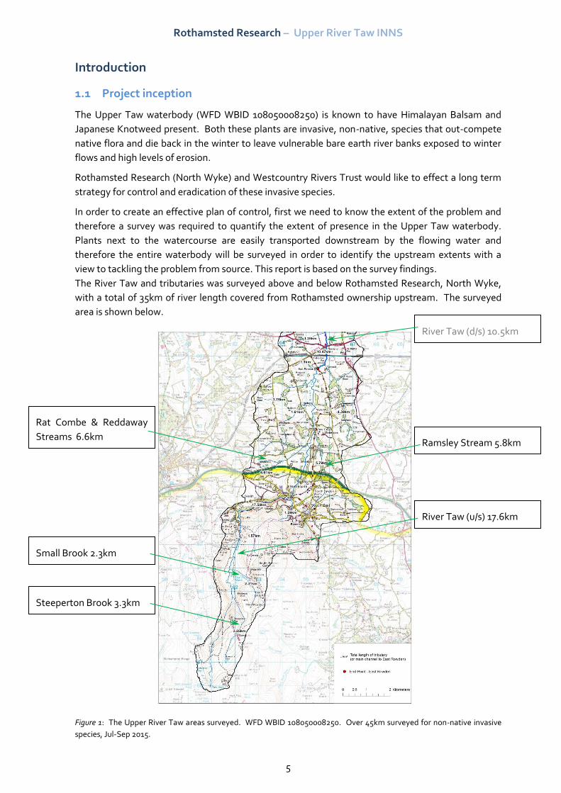
The Upper Taw waterbody (WFD WBID 108050008250) is known to have Himalayan Balsam and
Japanese Knotweed present. Both these plants are invasive, non-native, species that out-compete
native flora and die back in the winter to leave vulnerable bare earth river banks exposed to winter
flows and high levels of erosion.
Rothamsted Research (North Wyke) and Westcountry Rivers Trust would like to effect a long term
strategy for control and eradication of these invasive species.
In order to create an effective plan of control, first we need to know the extent of the problem and
therefore a survey was required to quantify the extent of presence in the Upper Taw waterbody.
Plants next to the watercourse are easily transported downstream by the flowing water and
therefore the entire waterbody will be surveyed in order to identify the upstream extents with a
view to tackling the problem from source. This report is based on the survey findings.
The River Taw and tributaries was surveyed above and below Rothamsted Research, North Wyke,
with a total of 35km of river length covered from Rothamsted ownership upstream. The surveyed
area is shown below.
Figure 1: The Upper River Taw areas surveyed. WFD WBID 108050008250. Over 45km surveyed for non-native invasive
species, Jul-Sep 2015.
Rat Combe & Reddaway
Streams 6.6km
River Taw (d/s) 10.5km
River Taw (u/s) 17.6km
Small Brook 2.3km
Steeperton Brook 3.3km
Ramsley Stream 5.8km
Rothamsted Research – Upper River Taw INNS
6
1.2 INNS monitored
Japanese Knotweed (Fallopia japonica) and Himalayan Balsam (Impatiens glandulifera) are invasive,
non-native species (INNS) of plant to Britain. The plants have detrimental and harmful effects
wherever they occur, dominating and out-competing native species.
Japanese Knotweed causes extensive structural damage to buildings, roadways, and bridges. The
rapid and ever increasing colonisation of river banks causes harm to structures, and also inflicts a
damaging effect on the environment. As a perennial plant it rapidly colonises an area of river bank
in summer, dies back in winter, and exposes the remaining bare river bank to the full erosive forces
of the high winter flows. Large areas of land are washed away and valuable salmonid spawning
gravels are choked with excess silt in the water column as a result.
Himalayan Balsam causes less damage to structures, but spreads at a fast rate by way of catapulting
its seeds. Each plant can contain up to 800 seeds and each seed is capable of being ‘fired’ up to 7m
from the plant. This means that a singular plant established one year can cover up to 154m2 of land
in the following year. As an annual plant it also rapidly colonises an area of river bank in summer
(from recently deposited seeds or from the historical seed ‘bank’), dying back in winter and exposing
the remaining bare river bank to the winter flows. Large areas of land are eroded and valuable
salmonid spawning gravels are choked with excess silt affecting the following years’ fish
recruitment.
The spread of Japanese Knotweed has been documented over the years. The plant’s invasive
colonisation in Britain is noteworthy. From the first instance of naturalisation in 1886, it was seen
wild in London in 1900 and near Slough by 1902. It reached Exeter by 1908, Suffolk by 1924, spread
to Yorkshire and Northumberland in the ‘forties and ‘fifties with colonies to be found throughout
the country from West Cornwall to the Outer Hebrides before 1965.
Japanese Knotweed (Fallopia japonica) is proscribed under the Wildlife and Countryside Act 1981
Schedule 9, Part 2. All parts of the plant and any soil contaminated with rhizomes are classified as
controlled waste.
Instances of these invasive plants have been reported along the river banks of the River Taw and its
tributaries and, as a duty of care, Rothamsted Research (North Wyke) has commissioned this
investigation of the extent of the occurrences. By surveying the main river waterbody this will
qualify the effort required to eradicate the species in the longer term rather than taking a yearly
budget to manage the plant in one specific area with no control or idea of source.
Both Himalayan Balsam and Japanese Knotweed are extremely detrimental as described above, but
the presence of the plant next to a watercourse, which offers the potential of a much accelerated
unidirectional spread is far worse. The presence next to a watercourse should facilitate an increased
priority for the eradication of the species.
A rapid walkover survey has been undertaken by the Westcountry Rivers Trust during 2015 to map
the extent of these species specifically, whilst noting other invasive species of interest.
1.3 Method
The walkover survey was conducted by two surveyors (Matt Healey and Yog Watkins, WRT)
between July and September of 2015. The main River Taw corridor was surveyed for Himalayan
Balsam, Japanese Knotweed and other non-native species, with the former being the primary focus
of the survey between Coldridge Bridge near Winkleigh, and the source of the river on Dartmoor;
Rothamsted Research – Upper River Taw INNS
7
covering the entire WFD WBID (Water Framework Directive, Water Body Identification) main river
of the Upper Taw.
Two surveyors are used due to the risk of working in and near moving water, and during summer
months the efficiency is markedly improved by teamwork accessing the river through mature
perennials.
All permissions were granted prior to the survey by phoning land owners or cold-calling.
Surveyors noted stands of Japanese Knotweed along the riparian corridor on a map and marked
lengths of river bank affected by Himalayan Balsam. Hand-held GPS was used to confirm locations.
In addition to the non-native species being surveyed other river protection issues may be noted
through additional funding from other sources.
Tributaries to the River Taw were tentatively investigated immediately above a confluence, usually
to the nearest slow water (permissions allowing) which might act as a key deposit area and indicate
whether or not there is contribution of Himalayan Balsam from this source.
All walkover surveys were fully digitised onto ArcGIS to quantify the extent of the target non-native
species.
All landowners contacted and/or encountered during the survey will have printed advice on the
control of Himalayan Balsam and Japanese Knotweed left with them for future reference.
Working on a not-for-profit basis, the main River Taw was surveyed to the uppermost tributaries in
order to identify the uppermost sources of invasives. This will directly compliment the top-down
control approach essential to eliminate the risk of further inputs coming from upstream.
Rothamsted Research – Upper River Taw INNS
8
Results
1.4 GIS
The appendices at the back of this report contain the mapped outputs of the survey carried out in
summer 2015. INNS data will also be included in the delivery to Rothamsted for their GIS systems
allowing further data interrogation.
1.5 Walkover - Limitations
Any survey that is carried out over a large geographical area will encounter problems, the most
common being the required access permissions to the survey area. In this project the largest delay
was the landowner contact. Once contacted everyone was very accommodating and willing to allow
us access to their land. Several farmers were particularly helpful in providing numbers and up to
date information regarding changes in ownership along the river corridor. Most of the delay came
from unconventional hours of the farming community, catching them at home was difficult and
often required several phone calls or several messages left before permissions granted. This is not a
criticism but a practical problem.
Despite being granted access, some of the riparian corridor did have other issues. Some of the
smaller tributaries surveyed were very overgrown and progress was slow. In some circumstances
reaching the river was not possible but surveying was carried out from as close to the watercourse
as is feasible. In most cases this amount of vegetation would also prove inhospitable to Himalayan
Balsam so very few stands were found in these areas.
Summer months are the best time to identify non-native plants on the river bank, however it is
recognised that there will be limitations to the survey due to poor surveying conditions on occasion
and vegetation along the riparian corridor will be overgrown meaning access is restricted in places
and it is possible some smaller stands may have been missed, any larger stands away from the
immediate river corridor could also be missed depending on location.
1.6 Findings
Over 45 km of river were surveyed between 14th of July and 18th September, much or the survey
work was carried out between 24th and 31st July, with the Ramsley and Rat Combe Streams
completed in early September.
Himalayan Balsam was found along the main stem of the River Taw in varying quantities all the way
from Coldridge Bridge to the edge of Dartmoor. Before the survey was started the locations of
known Japanese Knotweed (JK) (taken from the DBRC) were marked on the maps and checked for
accuracy during the survey.
Montbretia was the most surprising result of the walkover; it was expected but not as widespread.
Other INNS that stood out were Laurel and Rhododendron, with the latter being widespread.
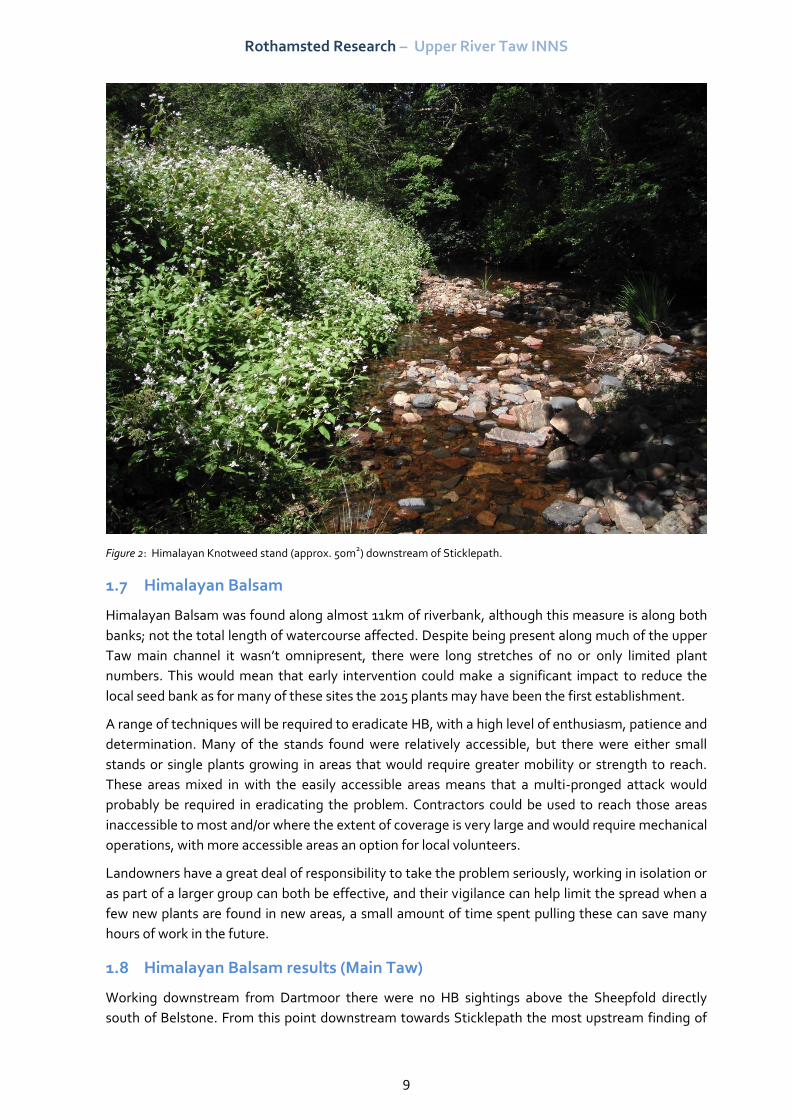
Several small/single Himalayan knotweed stands were found between Belstone and Sticklepath, but
more significant stands found just a little further downstream (SX 64494 94365) (see photo below).
Rothamsted Research – Upper River Taw INNS
9
Figure 2: Himalayan Knotweed stand (approx. 50m2) downstream of Sticklepath.
1.7 Himalayan Balsam
Himalayan Balsam was found along almost 11km of riverbank, although this measure is along both
banks; not the total length of watercourse affected. Despite being present along much of the upper
Taw main channel it wasn’t omnipresent, there were long stretches of no or only limited plant
numbers. This would mean that early intervention could make a significant impact to reduce the
local seed bank as for many of these sites the 2015 plants may have been the first establishment.
A range of techniques will be required to eradicate HB, with a high level of enthusiasm, patience and
determination. Many of the stands found were relatively accessible, but there were either small
stands or single plants growing in areas that would require greater mobility or strength to reach.
These areas mixed in with the easily accessible areas means that a multi-pronged attack would
probably be required in eradicating the problem. Contractors could be used to reach those areas
inaccessible to most and/or where the extent of coverage is very large and would require mechanical
operations, with more accessible areas an option for local volunteers.
Landowners have a great deal of responsibility to take the problem seriously, working in isolation or
as part of a larger group can both be effective, and their vigilance can help limit the spread when a
few new plants are found in new areas, a small amount of time spent pulling these can save many
hours of work in the future.
1.8 Himalayan Balsam results (Main Taw)
Working downstream from Dartmoor there were no HB sightings above the Sheepfold directly
south of Belstone. From this point downstream towards Sticklepath the most upstream finding of
Rothamsted Research – Upper River Taw INNS
10
HB was at SX 62139 93169, and due to the terrain there were few other HB plants until the cleave
opens out close to the bridge under the B3260 at Sticklepath.
The next section (Sticklepath to A30) has sporadic HB plants, but the predominant INNS problems
for this section were Himalayan Knotweed (see above), Japanese Knotweed, Rhododendron, Laurel
and Montbretia. The extent of the problem is easy to understand when you look at the land
management in this area. Large sections of the river passes by private gardens which run down to
the riverbank and contain many of the species mentioned above. The close proximity to the river,
and the number of private gardens, makes controls in this area difficult but they are likely to be the
most significant source of INNS into the Taw watercourse for a considerable distance.
Between the A30 and Taw Green the prevalence of HB increases steadily as you work downstream.
HB is found on both banks but often the larger stands are found on the inside of bends and in more
open areas. The first significant stands of HB are around SX 65067 95746.
From Taw Green downstream to the North Tawton Viaduct there were fewer stands of HB. It was
found consistently along this stretch but often in individual or <10 plant stands. It is minor stands of
this size that, now established, could propagate and cover a significant area within just one or two
years.
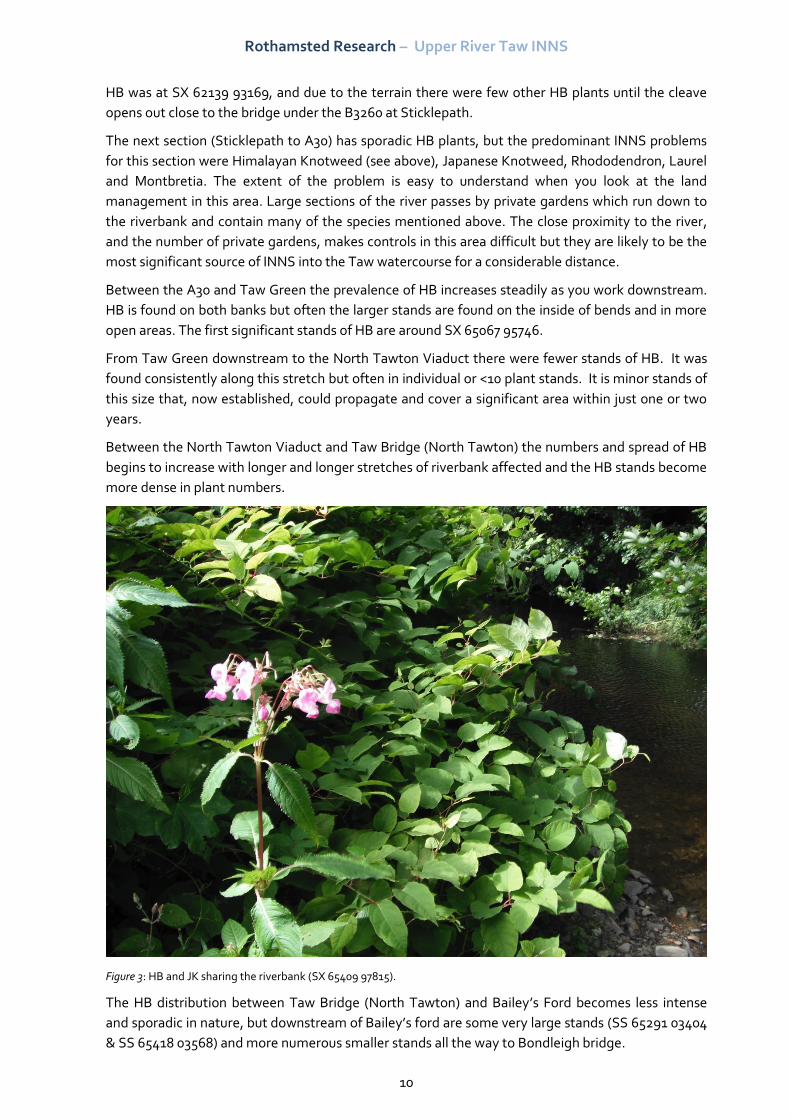
Between the North Tawton Viaduct and Taw Bridge (North Tawton) the numbers and spread of HB
begins to increase with longer and longer stretches of riverbank affected and the HB stands become
more dense in plant numbers.
Figure 3: HB and JK sharing the riverbank (SX 65409 97815).
The HB distribution between Taw Bridge (North Tawton) and Bailey’s Ford becomes less intense
and sporadic in nature, but downstream of Bailey’s ford are some very large stands (SS 65291 03404
& SS 65418 03568) and more numerous smaller stands all the way to Bondleigh bridge.
Rothamsted Research – Upper River Taw INNS
11
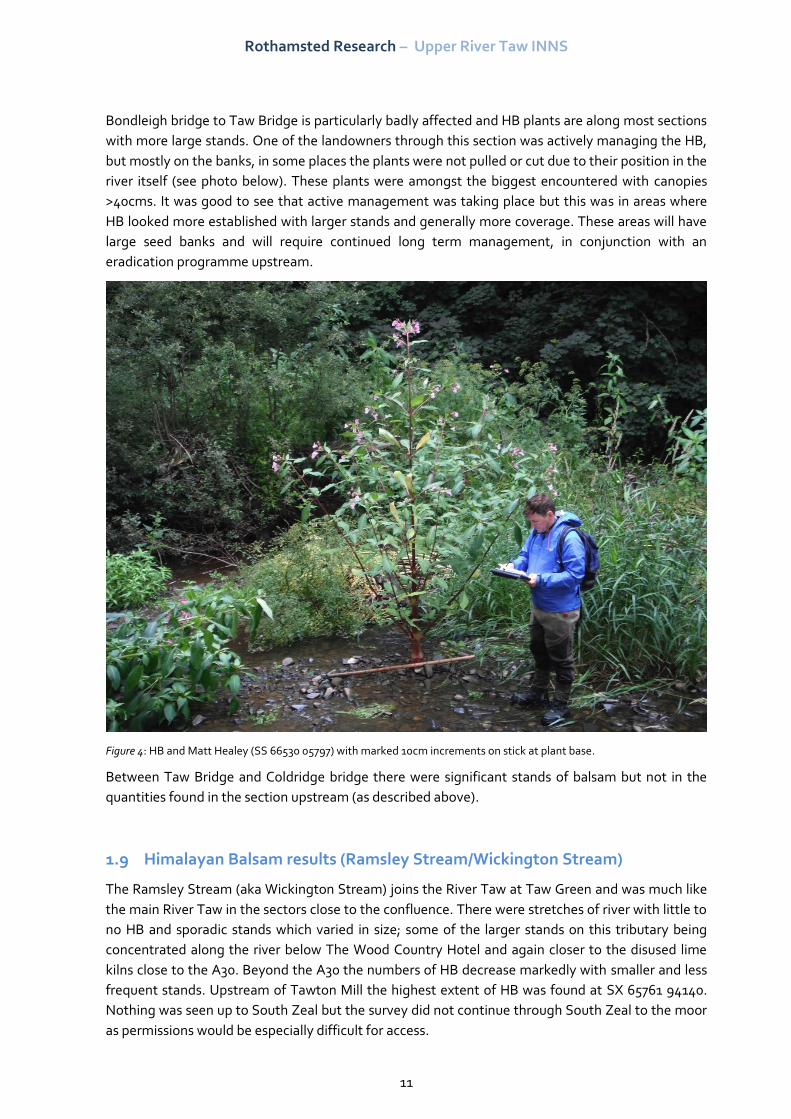
Bondleigh bridge to Taw Bridge is particularly badly affected and HB plants are along most sections
with more large stands. One of the landowners through this section was actively managing the HB,
but mostly on the banks, in some places the plants were not pulled or cut due to their position in the
river itself (see photo below). These plants were amongst the biggest encountered with canopies
>40cms. It was good to see that active management was taking place but this was in areas where
HB looked more established with larger stands and generally more coverage. These areas will have
large seed banks and will require continued long term management, in conjunction with an
eradication programme upstream.
Figure 4: HB and Matt Healey (SS 66530 05797) with marked 10cm increments on stick at plant base.
Between Taw Bridge and Coldridge bridge there were significant stands of balsam but not in the
quantities found in the section upstream (as described above).
1.9 Himalayan Balsam results (Ramsley Stream/Wickington Stream)
The Ramsley Stream (aka Wickington Stream) joins the River Taw at Taw Green and was much like
the main River Taw in the sectors close to the confluence. There were stretches of river with little to
no HB and sporadic stands which varied in size; some of the larger stands on this tributary being
concentrated along the river below The Wood Country Hotel and again closer to the disused lime
kilns close to the A30. Beyond the A30 the numbers of HB decrease markedly with smaller and less
frequent stands. Upstream of Tawton Mill the highest extent of HB was found at SX 65761 94140.
Nothing was seen up to South Zeal but the survey did not continue through South Zeal to the moor
as permissions would be especially difficult for access.
Rothamsted Research – Upper River Taw INNS
12
Where the Ramsley Stream splits and heads east just south of Tawton Mill this section was walked
to its source with full permissions. No HB was found but the terrain and vegetation was particularly
difficult which lead to slow progress in places.
1.10 Himalayan Balsam results (Rat Combe)
This stream wasn’t fully covered with a small section of the southern-most tributary not accessed
due to the recent death of the landowner. The Rat Combe was largely free of HB with only one large
stand of HB. This was unusual as it seemed very isolated, located in the woodland below Restland
Farm. As with the Ramsley Stream there was some difficulty in navigating sections of this stream
but in general the stream was fully surveyed and the HB noted.
Costs
Estimating the costs of HB removal on the Taw is difficult due to the terrain, varied access and
length of river involved. The following estimates are based upon the use of contractors at a daily
rate of £150 per person per day (excl VAT).
The prices below are estimated costs for a single year of action, including an initial eradication and
then a two return visits later in the season to pick up missed plants or subsequent regrowth.
1.11 Himalayan Balsam removal (Main Taw)
Section Number of days (£150/d/p) Cost
Coldridge Bridge to East
Rowden
45 £6,750
East Rowden to A30 24 £3,600
A30 to Belstone 10 £1,500
Total 79 £11,850 (+VAT)
1.12 Himalayan Balsam removal (Ramsley Stream)
Section Number of days (£150/d/p) Cost
Taw Green to Tawton Mill 12 £1,800
Total 12 £1,800 (+VAT)
1.13 Himalayan Balsam removal (Rat Combe)
Section Number of days (£150/d/p) Cost
Restland Farm to confluence 4 £600
Total 4 £600 (+VAT)
Rothamsted Research – Upper River Taw INNS
13
1.14 Long term eradication
One year of action will not suffice in most areas due to an underlying seed bank already established,
but would definitely be of benefit. It is important to allow for subsequent revisits in future years
eradicating HB where previous years plants have been missed or dormant seed banks have been
revitalised.
The two tributaries monitored below Dartmoor (Ramsley Stream and Rat Combe) would be ideal
candidates to start on as their coverage was manageable and also appears to be less established.
This is likely to mean that the seed bank is smaller; therefore with return visits, there is a greater
chance of successful eradication.
The main Upper Taw waterbody will require a long term action plan. The extent of the problem is
much greater and the size of some of the stands would suggest that they have become established
over several years, which in turn would mean that their eradication will be more difficult.
Past experience has shown that if using volunteers for Himalayan Balsam ‘pulls’ its best not to
expect them to work for more than a few hours at a time. The job is quite laborious and can
sometimes seem a little daunting. Work rates tend to fall away as the day progresses, therefore a
few hours in the morning or afternoon work well. This method also means that the volunteers can fit
in the ‘pull’ around other activities and not seem to take up a whole day of someone’s (often
precious) time. Volunteer numbers can often be good at the early stages of activity and it is vital to
maintain their enthusiasm, to help sustain the project over the many years of action required.
There may be opportunity for a ‘Pull 10’ campaign or similar project to tackle the more extensive
problem along the broadening main river. Elsewhere in the country a recent initiative has been
quite successful in educating members of the public about the identification and potential harm of
Himalayan Balsam and asking them to participate in active everyday control as they go about their
usual business. Rather than ask a few people to do a lot of work to control HB, the concept is
reversed and a lot of people are encouraged to do just a few actions to combat the issue. If
everybody that walks a public pathway by the river can pull 10 Himalayan Balsam plants as they
pass then it does not take a great deal of effort or time from each willing volunteer before the plants
are removed.
1.15 Long term eradication (Rothamsted Research, North Wyke)
Within the curtilage of Rothamsted Research, North Wyke an estimate of £1,200 is placed on the
first year’s contractor INNS control, with a minimum of 3 year’s visits recommended to follow up
and potentially eradicate the INNS from the river banks within ownership. Subsequent visits should
reduce in cost as the INNS decreases in presence.
A similar initiative of informing all staff of the potential harm and responsibility to control these
plants could be delivered and staff asked to contribute to the control when working or walking near
the river.
This should be conducted in conjunction with an upstream initiative to limit and potentially stop the
source of fresh seed input.
Rothamsted Research – Upper River Taw INNS
14
Conclusions
It is apparent from the overview maps in the appendices and the finer detail maps accompanying,
that Himalayan Balsam is the most widespread and problematic of invasive non-native species
along the river banks of the Upper River Taw and its tributaries. HB also has the highest risk of rapid
increase.
A long term plan is required to find a sustainable solution to this problem. A good education
programme would help benefit any ‘on the ground’ removals as the problem will require vigilance
and actions over the long term to keep the HB problem in check.
As mentioned earlier, starting on the side tributaries would offer the greatest chances of
successfully eradicating one cumulative source of INNS, but with the chances of cross-
contamination between catchments increases with every year of inaction.
The highest concentration of Himalayan Balsam lies along the main River Taw and action here is
essential.
It is understood that Rothamsted Research currently employs annual control of INNS, servicing the
responsibility of the land owner to control the spread of these species. It is important to continue
this regime, but equally important and recognised that controlling the upstream source of new
seeds is required.
The use of contractors in the short term will need to be backed up by volunteers and the landowners
who have a great collective power if utilised. A little and often can make a great difference, and
taking a few minutes to remove new plants in new areas, can save many hours of work in the future
should they be given the chance to establish.
As a result of this initial survey it is recommended that Rothamsted Research work in conjunction
with a wider catchment stakeholder group to raise awareness of INNS and promote the active
control and eradication of INNS in the Upper Taw waterbody.
Rothamsted Research – Upper River Taw INNS
15
Further information & contacts
Dr Russell Smith, Consultancy Director, BSc. MSc. PhD.
Russell is a Chartered Scientist and Environmentalist and Consultancy Director for Westcountry
Rivers Ltd. Russell has over 12 years' experience in catchment management/planning and
environmental monitoring working in the public and private sector and has considerable experience
in directing and managing diverse multi-discipline projects. Russell has been involved in the
application and development of farm, catchment to national scale models and decision support
tools since the late 1990’s in both research and consultancy. His experience in integrated catchment
modelling is complemented by his experience in monitoring and his detailed understanding of the
relationship between temporally and spatially variable catchment processes.
Email: [email protected]
Adrian Dowding, Westcountry Rivers Trust, North Devon
Adrian is a qualified marine and freshwater biologist and has worked at WRT for 9 years. With over
10 years’ experience in fish survey and management on a catchment scale, Adrian is a valuable
member of the fisheries team and has valuable experience in civil engineering project management
to help effect large-scale catchment change where it is required.
For further riparian corridor management advice within North Devon, Adrian is the person to
contact at WRT as the North Devon CaBA (Catchment Based Approach) Catchment Partnership
manager.
Ph: 01579 372 140
Email: [email protected]
Acknowledgements
Westcountry Rivers Trust would like to thank Carol Newman at Rothamsted Research, North Wyke,
for identifying funds, working with us, and commissioning this survey. We would also like to thank
the BBSRC who have funded this important work.
The Trust thanks all land owners involved in this survey for allowing their advisors on to their farm
and/or property in order to compile this report as part of the project.

Rothamsted Research – Upper River Taw INNS
16
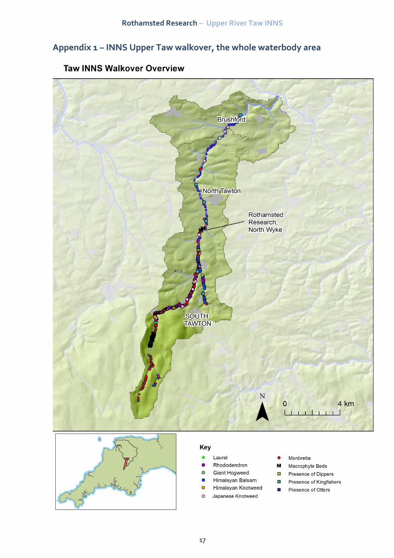
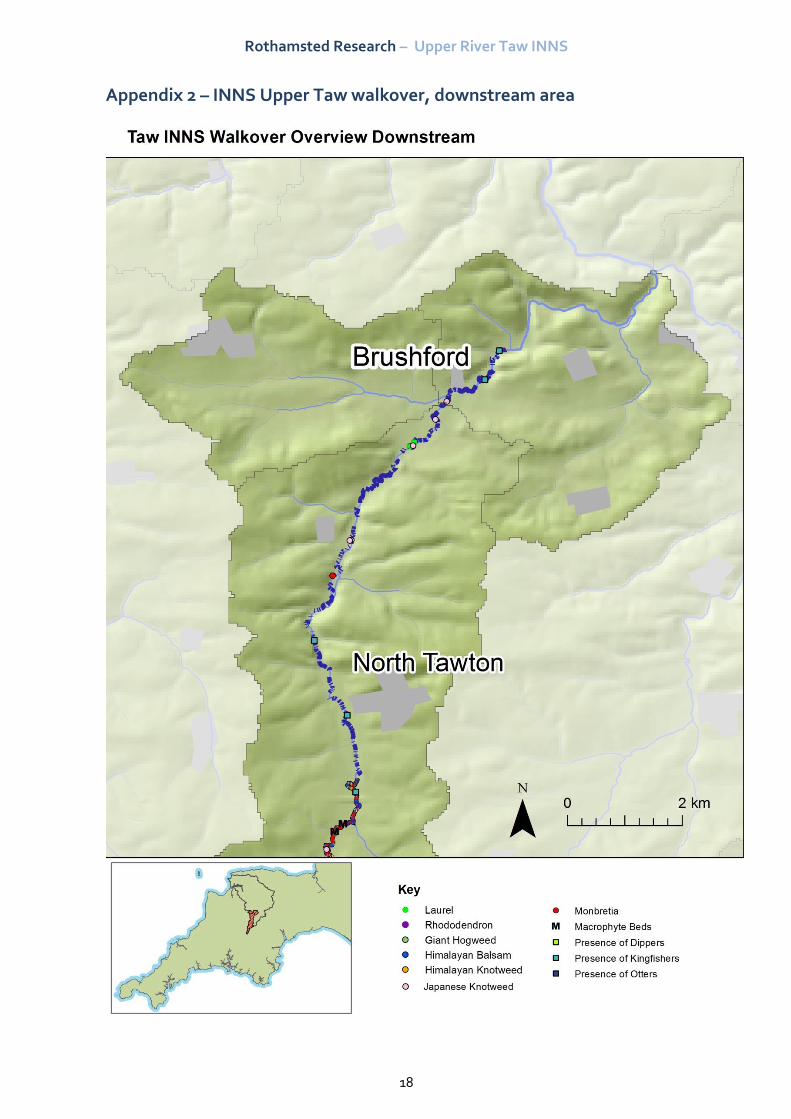
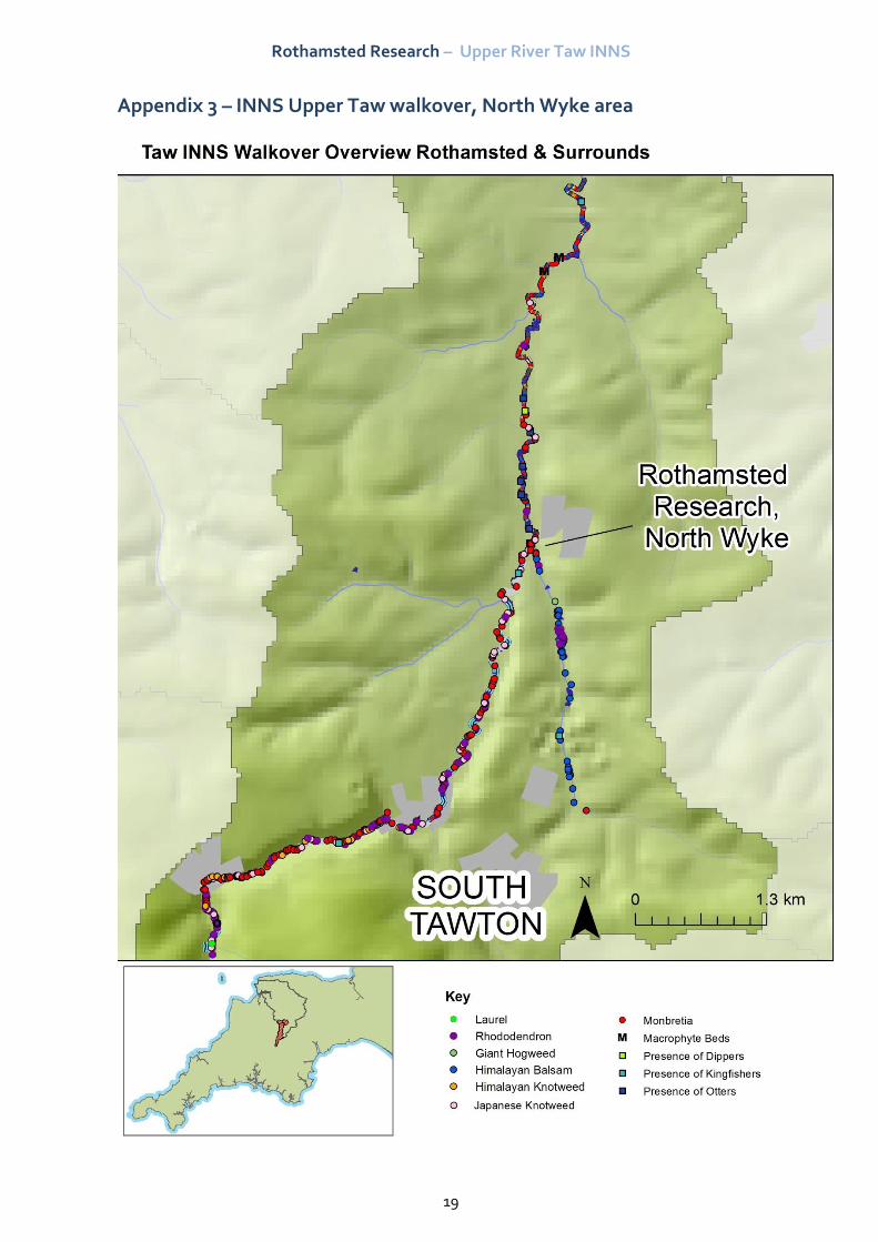
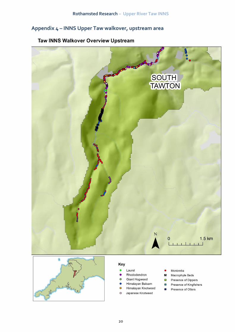
Appendices
Fine detail maps accompany this report alongside the GIS survey information generated in ArcGIS
v.10.1. They are produced as sequential PDFs and not directly appended to this report as there are
46 individual maps.
Fine detail maps are named according to watercourse and numbered from downstream, up.
Overview maps of the catchment are shown below.
Rothamsted Research – Upper River Taw INNS
17
Appendix 1 – INNS Upper Taw walkover, the whole waterbody area
Rothamsted Research – Upper River Taw INNS
18
Appendix 2 – INNS Upper Taw walkover, downstream area
Rothamsted Research – Upper River Taw INNS
19
Appendix 3 – INNS Upper Taw walkover, North Wyke area
Rothamsted Research – Upper River Taw INNS
20
Appendix 4 – INNS Upper Taw walkover, upstream area