upper bay planning region restoration opportunities crp
TRANSCRIPT
1
HUDSON-RARITAN ESTUARY COMPREHENSIVE RESTORATION PLAN
POTENTIAL RESTORATION OPPORTUNITIES
PROJECT SUMMARY SHEETS
Upper Bay Planning Region
Restoration Opportunities CRP Identification #: Site Name
37. Liberty State Park
154. Bush Terminal, Sunset Park 502. Coffey Street Park (Louis Valentino Jr.
Park and Pier) 504. Lower Bay Reef
503. Gowanus Canal
864. Governors Island

2
SITE 37. LIBERTY STATE PARK A. HARBOR ESTUARY PROGRAM SITE INFORMATION Category: Existing restoration, preservation, and/or mitigation site. Location: Located in Jersey City, New Jersey on the western side of Upper New York Bay. Watershed: Upper Bay Size: 240 Acres Ownership: New Jersey - NJDEP Site Description: Former marshland that was filled to create rail yards for the Central Railroad of New Jersey (1850s). Salt marshes were gradually eliminated during the industrial revolution. Site was converted to an urban park land in the 70s. Current Land Use: Active and passive recreation. Available Habitat: Aquatic, palustrine wetlands, small ponds, marsh, upland scrub-shrub. Approximately 60% of the current site supports scrub-shrub and the remainder supports perennial grasses. Historic shallow water with salt marsh fringe. The warm weather grasses provide forage and breeding areas for many passerine and raptor species. Circus cyaneus is a state listed species that has unsuccessfully nested in the park for the past several years. Other parts of the site are dominated by northern hardwood tree species and maritime shrub assemblages. Proposed Project: Permanent protection for natural areas within the park, possible emergent habitat enhancement and oyster bed restoration. Creation of salt marsh through North Cove. Creation and enhancement of freshwater wetlands adjacent to Liberty Science Center. Invasive species management. Construction of berm and upland buffer. Projected/Estimated Costs: $34.71M cost ($22.588.8M Federal, $12.162 (non-fed). Project Status: Feasibility study completed, authorized, and waiting appropriation. NJDEP construction sponsor advanced PED phase with $1M through USACE-NYD Interagency and International Services (IIS) Program (2007). In 2007, NJDEP implemented a 10 acre freshwater State NRD wetland mitigation project due to contaminant impacts. Primary restoration activities involved fill removal followed by plantings. This project experienced observed goose fence failure and extensive grazing. Partners: NJDEP and USACE Project Contact: John Sacco, NJ DEP; Lisa Baron, USACE Phone: (609) 292-2938, (917) 790-8306 Website: www.folsp.org, www.nj.gov/dep/nrr/, http://www.nan.usace.army.mil/project/newjers/factsh/pdf/liberty.pdf Project Funding Source: State of New Jersey, Federal Appropriations HEP Ratification Date: 7/1/1997

3
B. HUDSON RARITAN ESTUARY ECOSYSTEM RESTORATION STUDY INFORMATION Restoration Recommendations (Applicable Target Ecosystem Characteristics): Coastal Wetlands – Creation and enhancement of 26 acres of freshwater wetlands in center of the park along with drainage swales. Creation of 46 acres of salt marsh by excavating tidal creek (50 ft wide opening) through North Cove. Excavated material (~700,000 CY) for salt marsh will be used for a berm in the southwest corner of the site. Berm will improve water supply to interior wetland system. Upland buffer will sustain and protect the system. Habitat for Fish, Crab and Lobsters – Enhancement of shallow water habitat to create complex subtidal habitat with potential beneficial use of clean dredged material. Sediment Contamination – Potential dredging and capping of contaminated sediment based on testing. Public Access – Several public access points already exist at this site. Further opportunities exist for trails, canoe launches and improvements to existing wildlife sanctuaries. Upland Forest- Enhancement of 100 acres of urban hardwood and maritime forest and 50 acres of grassland would be restored. Benefits, Cost and Comparative Restoration Ratio: C. EXISTING SITE SPECIFIC DATA INVENTORY A. Survey, Maps and GIS: USACE, NJDEP regional data inclusive of this site, Alderson and Bower 2012. B. Site History and Land Use: (USACE, 2005) C. Biological Studies/ Fauna: Biological resources; amphibians and reptiles, birds and mammals, threatened and endangered species, benthic invertebrates, fish, essential fish habitat (USACE, 2005). D. Biological Studies/ General Environment: Site and vegetation surveys (USACE, 2005). E. Geotechnical: Geology, topography and soils (USACE, 2005).
F. Hydraulics and Hydrology: Regional hydrogeology and groundwater (USACE, 2005). G. Water and Sediment: Surface waters, water quality, heavy metals and sediment data (USACE, 2005) H. Historical and Cultural Resources: (USACE, 2005). I. Restoration Remediation and Design Plans: (USACE, 1998), (USACE, 2005), Alderson and Bower 2012.
REFERENCES: New York District U.S. Army Corps of Engineers (USACE). 2005. Hudson-Raritan Estuary, Liberty State Park Ecosystem Restoration Integrated Feasibility Report & Environmental Impact Statement. U.S. Fish and Wildlife Service Ecological Services Region 5. 2006. Fish and Wildlife Coordination Act Section 2(b) Report Assessment of the Hudson –Raritan Estuary Liberty State Park Ecosystem Restoration Project. Alderson, Carl and Justin Bowers. 2012. Reaching for the Past in Pursuit of the future: how can our present and past efforts inform the Hudson-Raritan Estuary Comprehensive Restoration Plan and the direction of habitat restoration going forward. A project for the New York-New Jersey Harbor & Estuary Program and New England Interstate Water Pollution Control Commission. New York District U.S. Army Corps of Engineers (USACE). 2006. Chief of Engineers Report- Hudson Raritan Estuary, New Jersey, Liberty State Park. Baron, Lisa and Peter Weppler. 2009. HRE Hudson Raritan Estuary Comprehensive Restoration Plan Study (PowerPoint)

4
New York District U.S. Army Corps of Engineers (USACE). 2000. Hudson Raritan Estuary, New York, New Jersey Section 905 (b). Feasibility Cost Sharing Agreement (FCSA)- executed on July 12, 2001 with The Port Authority of New York and New Jersey (PANYNJ), the non-Federal sponsor. Liberty State Park Interior Restoration Report

5

6
CRP SITE 154. BUSH TERMINAL, SUNSET PARK A. HARBOR ESTUARY PROGRAM SITE INFORMATION Category: Existing restoration, preservation, and/or mitigation site. Location: Between Piers 3 and 4, Bush Terminal, lies between Bay Ridge and Gowanus Watershed: Upper Bay Size: 24 acres Ownership: NYCEDC Site Description: Prior to 1974, the Bush Terminal site was an active port. As of 2006, the car floats and Bush Terminal Rail Yard are operated by New York New Jersey Rail, LLC and used occasionally to deliver New York City Subway cars via the South Brooklyn Railway. Soil, groundwater, and sediment at and underneath the site became contaminated in the 1970s due to the unauthorized disposal of construction and demolition debris and liquid waste including oils, oil sludges, and wastewater. Current Land Use: Degraded industrial parcel. DEC classified the site as a Class 3 inactive hazardous waste disposal site. Available Habitat: Open Space, wetland, recreation. Proposed Project: Marsh Restoration. DEC issued a March 2004 Record of Decision for a cleanup plan that will include: institutional controls and monitoring; installation of a 2-foot soil cover with 6-inch soil cover in the wooded area; landfill gas controls and monitoring; groundwater controls and monitoring; excavation and removal of shallow pond area sediments; filling and covering of deep pond area sediments; and shoreline stabilization. Once the cleanup is complete, the City plans to redevelop the site as a public open space featuring a variety of both active and passive recreational uses including: athletic fields; walkways; natural areas; an environmental education center; a boat-building area; a fishing pier; seasonal restaurant booths; a community building; and a banquet hall. The project also includes pier rehabilitation, shoreline stabilization, wetlands and aquatic habitat enhancement, the preservation of mature trees and stormwater best management practices. Projected/Estimated Costs: $3M; $36K Project Status: The recontouring and capping of the deep water ponds was completed in 2013 as was restoration of salth marsh habitat along the pond edge. Shoreline stabilization was also completed along the majority of the site by 2013. Funding has not yet been secured for Phase 2 of the project, which will redevelop Pier 5 and bring additional improvements to Piers 1-4. Phase 2 is expected to cost approximately $24 -$35M. City Planning Commission passed the Sunset Park rezoning in October 2009. Partners: NYCDEC and NYCEDC Project Contact: Alyssa Cobb, NYCEDC Phone: (212) 312-3890 Website: www.newyorkbiz.com Project Funding Source: Environmental Protection Fund (EPF): NYSDOS EPF grant for design of waterfront park, including wetland restoration; NYSDEC Brownfields Bond Act funds for construction (pending). Funding committed as of 2006: NY State ($17.8M), New York City ($9M), Federal Government ($8M), the State will provide a $700,000 EPF grant and Councilmember Sarah Gonzalez helped to provide $500,000 to help transform this site into a recreational park.

7
Funding committed as of 2009: Mayor Bloomberg announced the Sunset Park Waterfront development plan would be supported by $270M in funding, $165M from the City and $105M from state, Federal, and private dollars. HEP Ratification Date: 12/11/1997 B. HUDSON RARITAN ESTUARY ECOSYSTEM RESTORATION STUDY INFORMATION
Restoration Recommendations (Applicable Target Ecosystem Characteristics): Coastal Wetlands – Creation of ~ 4.17 acres of marsh habitat in waterfront open sites near ponds would require regrading to wetland elevation (potential placement of excavated materials in existing ponded areas), removal of invasives and planting of native marsh species. Shorelines and Shallows – Enhancement of shallow water habitat to include re-grading of shoreline and creation of naturally sloping habitat with potential beneficial use of clean excavated material and removal of derelict structures and debris along ~ 6,125 feet of shoreline.
Habitat for Fish, Crab and Lobsters – Enhancement of shallow water to create complex subtidal habitat and removal of derelict structures and debris from subtidal area in ~ 2.27 acres. Sediment Contamination – Potential dredging and capping with clean sediments based on sediment contamination testing. Public Access – Creation of multiple waterfront access points including fishing areas, ball fields, ice hockey rink, park space and ~ 3, 500 feet of paths.
Benefits, Cost and Comparative Restoration Ratio: C. EXISTING SITE SPECIFIC DATA INVENTORY
A. Survey, Maps and GIS: USACE, NYSDEC & NYSEDC regional data inclusive of this site. B. Site History and Land Use: Several accounts of site history available. C. Biological Studies/ Fauna: No data obtained D. Biological Studies/ General Environment: Environmental site evaluation (DEC 1999-200l).
E. Geotechnical: No data obtained F. Hydraulics and Hydrology: No data obtained G. Water and Sediment: No data obtained H. Historical and Cultural Resources: No data obtained I. Restoration Remediation and Design Plans: Site visioning (NYSEDC 2009)
REFERENCES:
Barowitz J. & Falk J. 2006. Mayor Bloomberg and Governor Pataki announce $36 million for environmental cleanup and redevelopment of bush piers. News from the Blue Room. www.nyc.gov The Seafarers International Union, Atlantic, Gulf, Lakes and Inland Waters District/NMU, AFL-CIO. 2006. Floating Railroad Continues a Proud Tradition. http://www.seafarers.org/log/2006/112006/railcar.xml. Retrieved 19 January 2010.
Plan NYC. 2009. Sunset Park Waterfront Vision Plan & Bush Terminal Piers Park. http://www.plannyc.org/taxonomy/term/711
New York City Economic Development Committee. 2009. Sunset Park Waterfront Vision Plan.
New York State Department of Environmental Conservation. 2001. Comprehensive Environmental Site Evaluation of Sunset Park.
New York State Department of Environmental Conservation, Division of Environmental Remediation. 2004. Environmental Restoration Record of Decision, Bush Terminal Landfill Piers 1-4, Brooklyn, Kings County, New York, Site Number B00031-2, p. 2-3.

8

9
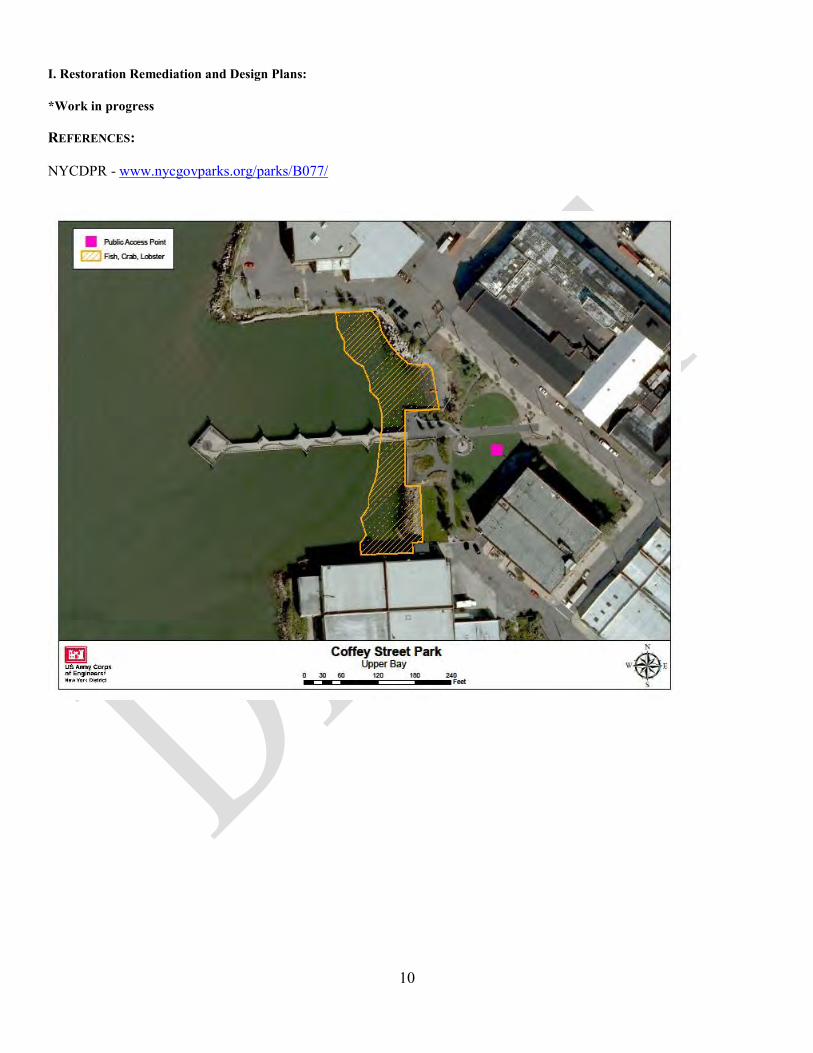
CRP SITE 502. COFFEY STREET PARK (LOUIS VALENTINO JR. PARK AND PIER)
A. HARBOR ESTUARY PROGRAM SITE INFORMATION Category: Existing restoration, preservation, and/or mitigation site. Location: At the corner of Coffey Street and Ferris Street, Brooklyn NY. Watershed: Red Hook Channel Size: Ownership: NYCDPR - NRG Site Description: Valentino Pier was once the site of an active shipping industry. The park was originally built in 1996 by NYCEDC before becoming a city park in 1999. This site is primarily recreational with limited TEC restoration opportunities. Current Land Use: Active and passive recreation Available Habitat: Site contains recreational park and ball field. Shoreline is lined with riprap and contains gently graded gravel beach used for boat and kayak launch. Proposed Project: NYCDPR has plans to enhance the site as a destination for bicyclists and pedestrians. Projected/Estimated Costs: Project Status: Some renovation at Coffey Park was completed on July 7, 1999. Partners: NYCDPR Project Contact: Phone: Website: Project Funding Source: HEP Ratification Date: B. HUDSON RARITAN ESTUARY ECOSYSTEM RESTORATION STUDY INFORMATION Restoration Recommendations (Applicable Target Ecosystem Characteristics): Habitat for Fish, Crab and Lobsters – Opportunity exists for enhancement ~ 0.67 acres of the shallow water environment to create complex subtidal habitat where derelict structures and debris appear.
Public Access – Site contains recreational park and boat launch. NYC DPR has plans for further recreational improvements.
Benefits, Cost and Comparative Restoration Ratio: C. EXISTING SITE SPECIFIC DATA INVENTORY A. Survey, Maps and GIS: B. Site History and Land Use: C. Biological Studies/ Fauna: D. Biological Studies/ General Environment:
E. Geotechnical: F. Hydraulics and Hydrology: G. Water and Sediment: H. Historical and Cultural Resources:
10
I. Restoration Remediation and Design Plans: *Work in progress REFERENCES: NYCDPR - www.nycgovparks.org/parks/B077/

11
CRP SITE 504. LOWER BAY REEF A. HARBOR ESTUARY PROGRAM SITE INFORMATION Category: Existing restoration, preservation, and/or mitigation site. Location: 0.2 miles north of the corner of Shore Road and 68th Street, Kings County, NY. Watershed: Size: Ownership: Site Description: Current Land Use: Available Habitat: Proposed Project: Artificial reef construction (USACE 2001, NMFS). NMFS offers design guidance for potential reefs at these sites, based on the experimental Dutch Harbor reefs. Suggested rock size ranges are 3 to 20 cm, and 20 to 40 cm, to accommodate juvenile and larger sized lobsters, a Federally managed species. NMFS suggests that each reef consist of abutting sections of the two size classes. The USACE (1999a) calculated that the construction of a 1-acre estuarine reef with 3 ft of relief would require approximately 5,000 cu yd of bedrock. The study concludes that sediments at this location may be able to support the weight of rock reef structures. Projected/Estimated Costs: Project Status: Partners: Project Contact: Phone: Website: Project Funding Source: HEP Ratification Date:

12
B. HUDSON RARITAN ESTUARY ECOSYSTEM RESTORATION STUDY INFORMATION Restoration Recommendations (Applicable Target Ecosystem Characteristics): Habitat for Fish, Crab and Lobsters – Construct ~ 1 acre artificial reef (e.g. rock, rubble mound or reef balls) to increase availability of structural refuge habitat for juvenile and adult finfish and crustaceans, including Essential Fish Habitat species and endangered species,
that is currently lacking in the Upper Bay and similar habitats throughout the Harbor. Navigational and habitat exchange concerns will need to be addressed. Sediment Contamination - Potential removal/capping of contaminated sediment based on testing.
Benefits, Cost and Comparative Restoration Ratio: C. EXISTING SITE SPECIFIC DATA INVENTORY A. Survey, Maps and GIS: B. Site History and Land Use: C. Biological Studies/ Fauna: D. Biological Studies/ General Environment: E. Geotechnical:
F. Hydraulics and Hydrology: G. Water and Sediment: H. Historical and Cultural Resources: I. Restoration Remediation and Design Plans:
*Work in progress REFERENCES: USACE. 2001. “Restoration Opportunities in the Hudson-Raritan Estuary.” U.S. Army Corps of Engineers, New York District, New York, NY. USACE- Joel Banslaben, Jack C. Cox, and Robert J. Will. July 2003. Dredging Operations Technical Support Program - Beneficial Use of Dredged Bedrock in the New York/New Jersey Harbor.

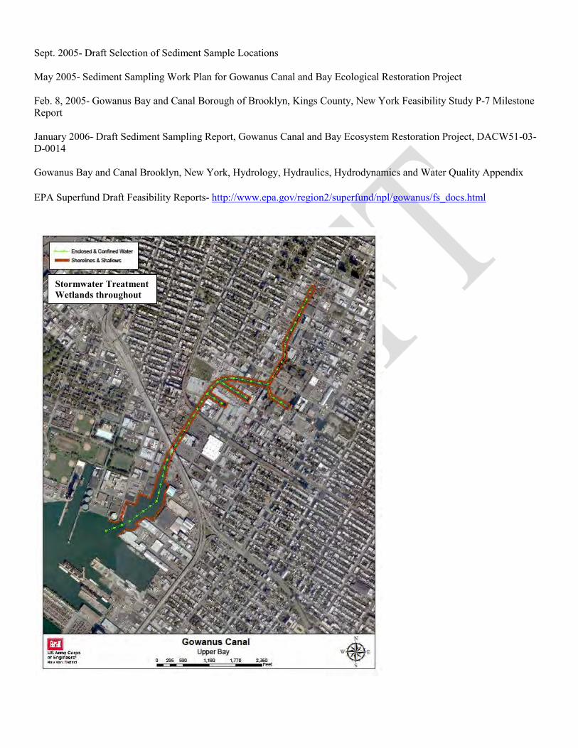
CRP SITE 503. GOWANUS CANAL A. HARBOR ESTUARY PROGRAM SITE INFORMATION Category: Existing restoration, preservation, and/or mitigation site. Location: Northeast corner of the Upper New York Bay, Brooklyn Watershed: Upper Bay Size: 20 acres Ownership: NYCDEP Site Background: The Gowanus Creek Canal, constructed in 1881 to accommodate industrial users and commercial shippers on the Brooklyn waterfront, extends approximately one mile north of the Hamilton Avenue Bridge. Years of industrialization and urbanization, coupled with inadequate systems for sewage disposal transformed this into a polluted, stagnant, degraded waterway. In 1911, in response to increasing levels of water pollution, the City built a "flushing tunnel" to disperse pollutants by using a propeller to flush water from the Buttermilk Channel through the Canal. Current Land Use: The industrial uses in and around the canal have resulted in significant deposition of hazardous materials on the bottom, with detrimental changes to existing habitat. This material may pose a risk to wildlife, is a nuisance to local residents, and discourages private sector investment in the area. Recreational, commercial, and housing opportunities are minimal. Available Habitat: Severely degraded estuarine habitat. Proposed Project: NYC DEP Preliminary Plans, HRE spin-off Projected/Estimated Costs: Estimated Feasibility Federal Cost $2,500,000. Estimated Feasibility NYC DEP Cost $2,500,000. Total $5,000,000 Project Status: March 4, 2010, the EPA placed the Gowanus Canal on its Superfund National Priorities List. Reconnaissance Phase initiated in Jan 2000; Section 905(b) WRDA 86 analysis fact sheet approved by HQUSACE July 2000, recommending a feasibility study. The non-Federal sponsor is the New York City Department of Environmental Protection (NYCDEP). The FCSA was signed 8 Jan 02. Feasibility phase began 1 Feb 02.Work completed: Benthic and Invertebrate Sampling; Hydrology, Hydraulic and Water Quality Report; National Register of Historic Places Review; Upland Site Evaluation; Wetland Creation Evaluation; Sediment Quality Evaluation. Work underway: Alternatives analysis report; sediment transport modeling; EIS/Integrated Feasibility Report. Focus is on 312B Environmental Dredging project prior to habitat restoration to insure sustainability and measure the environmental problems and potential solutions for the Gowanus Canal area. Potential restoration measures include remediation (per USEPA Superfund Program), contaminant reduction measures (NYCDEP), creation of wetlands, water quality improvements, and alteration of hydrology/hydraulics to improve water movement and quality. Partners: NYCDEP, USACE Project Funding Source: HEP Ratification Date:

B. HUDSON RARITAN ESTUARY ECOSYSTEM RESTORATION STUDY INFORMATION Restoration Recommendations (Applicable Target Ecosystem Characteristics): Sediment Contamination – Severely polluted estuarine habitat. All habitat restoration concepts should not be explored until remediation is completed by EPA and water quality is improved through CSO regulation/upgrades. Shorelines and Shallows – Shoreline softening and stabilization along ~ 20,400 feet of shoreline. Assess
possibility of bulkhead removal or terraced tidal flat addition to bulkhead. Enclosed and Confined Waters - Restoration of tidal flow and enhancements to stormwater control to improve fish and wildlife habitat value and water quality function throughout the entire ~ 9,800 foot creek. Wetlands - Creation of stormwater treatment wetlands (including turning basin).
Benefits, Cost and Comparative Restoration Ratio: C. EXISTING SITE SPECIFIC DATA INVENTORY A. Survey, Maps and GIS: USACE, NYSDEC & NYSEDC regional data inclusive of this site. B. Site History and Land Use: Several accounts of site history available. C. Biological Studies/ Fauna: Biological sampling D. Biological Studies/ General Environment: Fish and epibenthic invertebrate report, general investigations studies (2003, 2004). E. Geotechnical: Geotech Sampling, characterization of the sediments physical conditions.
F. Hydraulics and Hydrology: Hydrology and hydraulic analysis and modeling, receiving water analysis, bathymetric surveys (1989). G. Water and Sediment: Water quality and hydrological modeling, two phases of sediment sampling for contaminates (2004, 2005, 2006) H. Historical and Cultural Resources: 2003 I. Restoration Remediation and Design Plans: USACE feasibility study in progress.
References: U.S. Army Corps of Engineers. 1989. Gowanus Bay and Canal Brooklyn, New York Hydrology, Hydraulics, Hydrodynamic and Water Quality Appendix. Oct. 2003- Gowanus Study Area Data Assessment Report
Aug. 2003- Gowanus Canal Benthic Sampling Data Nov. 2004- Gowanus Bay Canal Ecosystem Restoration studies: Fish and Epibenthic Invertebrate Sampling Program, Final Report Oct. 2004- Final Report, Sediment Quality Evaluation Report Gowanus Canal and Bay Ecological Restoration Project, DACW51-01-D-0017*
July 2004- Wetland Creation General Investigation Report
July 2004- Final Phase I Upland Site Assessment Feb. 2004- Draft Literature Search Report for Phase 1 Upland Site Assessment
2004- National Register of Historic Places Eligibility Evaluation and Cultural Resources Assessment for the Gowanus Canal, Borough of Brooklyn, Kings County, New York, In Connection with the Proposed Ecosystem Restoration Study. Hunter Research, Inc., Raber Associates, and Northern Ecological Associates, Inc.
Sept. 2005- Draft Selection of Sediment Sample Locations
May 2005- Sediment Sampling Work Plan for Gowanus Canal and Bay Ecological Restoration Project Feb. 8, 2005- Gowanus Bay and Canal Borough of Brooklyn, Kings County, New York Feasibility Study P-7 Milestone Report January 2006- Draft Sediment Sampling Report, Gowanus Canal and Bay Ecosystem Restoration Project, DACW51-03-D-0014
Gowanus Bay and Canal Brooklyn, New York, Hydrology, Hydraulics, Hydrodynamics and Water Quality Appendix EPA Superfund Draft Feasibility Reports- http://www.epa.gov/region2/superfund/npl/gowanus/fs_docs.html
Stormwater Treatment Wetlands throughout

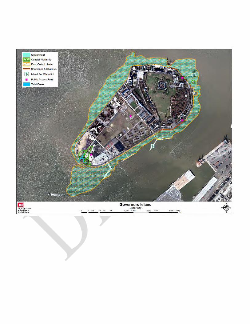
CRP SITE 864. GOVERNORS ISLAND A. HARBOR ESTUARY PROGRAM SITE INFORMATION Category: Existing restoration, preservation, and/or mitigation site. Location: Located in the Upper New York Bay approximately 0.5 miles south of the southern tip of Manhattan. Watershed: Upper Bay Size: 172 acres Ownership: The Trust for Governors Island, National Park Service Site Description: Governors Island was sold by the Federal Government to New York City and New York State through the Governors Island Preservation and Education Corporation (GIPEC), a sub-corporation to the Empire State Development Corporation. A National Monument, managed by the National Park Service, occupies 22 acres of the island. The remaining 150 acres of the island is controlled by GIPEC. A Historic District, consisting of 90 acres, is encompassed within the 172 acres. The South Island, approximately 80 acres south of Division Road, was created between 1901 and 1912 from material from the excavation of the Lexington Avenue subway line. Due to its geographic position along the Atlantic migration routes of many bird species, Governors Island has the potential to be a valuable stopover habitat for migrants passing through the metropolitan area. Current Land Use: Available Habitat: Proposed Project: Re-development of park and public space. Restoration Plan to be developed as “First Phase Implementation Site” pursuant to the Hudson-Raritan Estuary Restoration Feasibility Study. Projected/Estimated Costs: Project Status: The Island's future park and public spaces, designed by West 8, are now under construction. The Bloomberg Administration is investing more than $250 million to build an extraordinary new park and public spaces and to bring the Island's infrastructure into the 21st century. Mayor Bloomberg, elected officials and The Trust for Governors Island broke ground on the new park and public spaces in May 2012. Phase 1 creates 30 new acres of park at the heart of the Island and adds key visitor amenities. Phase 1 is part of a multi-phase 87 acre Park and Public Space Plan. Phase 1 comprises 64 acres of the Plan. Partners: NY Harbor School/Foundation and Trust for Governors Island Project Contact: Murray Fisher, President NY Harbor Foundation Phone: 212.458.0847 Website: Project Funding Source: HEP Ratification Date:

B. HUDSON RARITAN ESTUARY ECOSYSTEM RESTORATION STUDY INFORMATION Restoration Recommendations (Applicable Target Ecosystem Characteristics): Coastal Wetlands – Potential to create ~3 acres of tidal wetland in the southwest portion of the island, to include the creation of tidal channel. Additionally, a floating wetland in the eco-dock area will provide habitat and wave attenuation. Oyster Reefs - Implement future oyster restoration efforts on, and/or in the waters adjacent to, the new rip-rap revetment proposed for the west and south sides of Governors Island as part of the Governors Island seawall rehabilitation project and the shallow water area (roughly 18’ contour) surrounding the island. This will include the placement of appropriate hard substrate for a total of ~160 acres. Shorelines and Shallows – Enhance shallow water habitat along ~1,200 linear feet of existing sandy shoreline and creation of a terraced tidal flat along a portion of the shoreline, south of the eco-dock. Habitat for Fish, Crab and Lobsters – Opportunity exists to enhance ~160 acres of the shallow water/mudflat environment to create complex subtidal
habitat through the addition of reefballs and boulder field to the planned revetment. Sediment Contamination - Potential removal/capping of contaminated sediment based on testing. Public Access – Support ongoing activities of The Trust for Governors Island, for public access and environmental education improvements. The following areas are under construction and scheduled to open in 2013:
Liggett Terrace: a sunny, six acre plaza that features moveable seating, public art, water features and seasonal plantings
Hammock Grove: 10 acres with 1,500 new trees and hammocks
Play Lawn: 14 acres including lawn and two turf ball fields for play
Historic District: 34 acres of respectfully rejuvenated landscapes with new welcoming gateways, flexible spaces for play and new signage, lighting and amenities.
Benefits, Cost and Comparative Restoration Ratio: C. EXISTING SITE SPECIFIC DATA INVENTORY A. Survey, Maps and GIS: B. Site History and Land Use: NYC FGIS 2011 C. Biological Studies/ Fauna: NYC FGIS 2011 D. Biological Studies/ General Environment: NYC FGIS 2011 E. Geotechnical:
F. Hydraulics and Hydrology: G. Water and Sediment: NYC FGIS 2011 H. Historical and Cultural Resources: I. Restoration Remediation and Design Plans:
*Work in progress REFERENCES: The Trust for Governors Island- http://govisland.com/html/future/future.shtml West 8 rendering- Park and Open Space Plan- http://www.govislandpark.com/
The City of New York Governors Island FGIS for the phased redevelopment of Governors Island (2011): http://home.nyc.gov/html/oec/downloads/pdf/dme_projects/11DME007M/FGEIS/11DME007M_Notice_of_Completion_FGEIS.pdf http://www.nyc.gov/html/oec/downloads/pdf/dme_projects/11DME007M/FGEIS/11DME007M_FGEIS_10_Natural_Resources.pdf Oyster Restoration Research Partnership http://www.nynjbaykeeper.org/index.php?option=com_content&view=article&id=98&Itemid=68