unmanned aerial vehicle (uav) reports · pdf fileasrs database report set . unmanned aerial...
TRANSCRIPT
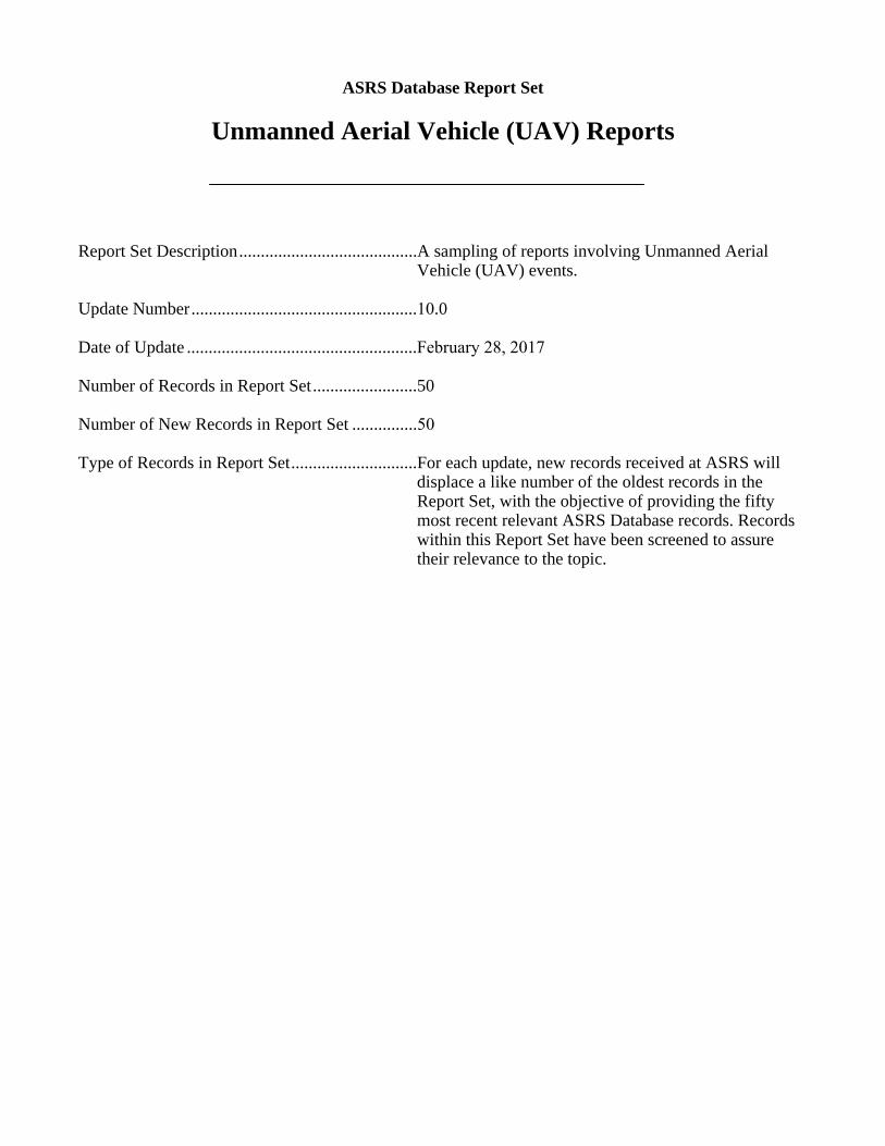
ASRS Database Report Set
Unmanned Aerial Vehicle (UAV) Reports
Report Set Description .........................................A sampling of reports involving Unmanned Aerial Vehicle (UAV) events.
Update Number ....................................................10.0
Date of Update .....................................................February 28, 2017
Number of Records in Report Set ........................50
Number of New Records in Report Set ...............50
Type of Records in Report Set .............................For each update, new records received at ASRS will displace a like number of the oldest records in the Report Set, with the objective of providing the fifty most recent relevant ASRS Database records. Records within this Report Set have been screened to assure their relevance to the topic.
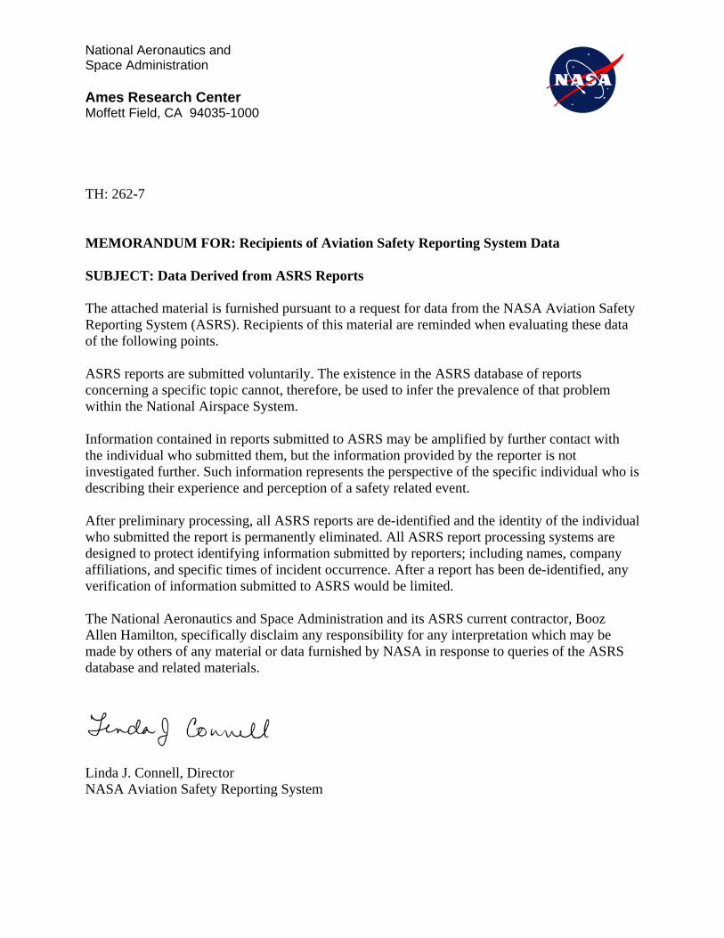
National Aeronautics and Space Administration
Ames Research Center Moffett Field, CA 94035-1000
TH: 262-7
MEMORANDUM FOR: Recipients of Aviation Safety Reporting System Data
SUBJECT: Data Derived from ASRS Reports
The attached material is furnished pursuant to a request for data from the NASA Aviation Safety Reporting System (ASRS). Recipients of this material are reminded when evaluating these data of the following points.
ASRS reports are submitted voluntarily. The existence in the ASRS database of reports concerning a specific topic cannot, therefore, be used to infer the prevalence of that problem within the National Airspace System.
Information contained in reports submitted to ASRS may be amplified by further contact with the individual who submitted them, but the information provided by the reporter is not investigated further. Such information represents the perspective of the specific individual who is describing their experience and perception of a safety related event.
After preliminary processing, all ASRS reports are de-identified and the identity of the individual who submitted the report is permanently eliminated. All ASRS report processing systems are designed to protect identifying information submitted by reporters; including names, company affiliations, and specific times of incident occurrence. After a report has been de-identified, any verification of information submitted to ASRS would be limited.
The National Aeronautics and Space Administration and its ASRS current contractor, Booz Allen Hamilton, specifically disclaim any responsibility for any interpretation which may be made by others of any material or data furnished by NASA in response to queries of the ASRS database and related materials.
Linda J. Connell, Director NASA Aviation Safety Reporting System
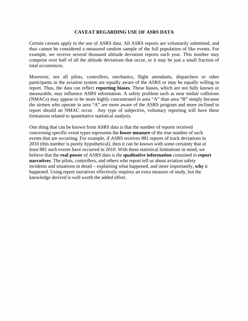
CAVEAT REGARDING USE OF ASRS DATA
Certain caveats apply to the use of ASRS data. All ASRS reports are voluntarily submitted, and thus cannot be considered a measured random sample of the full population of like events. For example, we receive several thousand altitude deviation reports each year. This number may comprise over half of all the altitude deviations that occur, or it may be just a small fraction of total occurrences.
Moreover, not all pilots, controllers, mechanics, flight attendants, dispatchers or other participants in the aviation system are equally aware of the ASRS or may be equally willing to report. Thus, the data can reflect reporting biases. These biases, which are not fully known or measurable, may influence ASRS information. A safety problem such as near midair collisions (NMACs) may appear to be more highly concentrated in area “A” than area “B” simply because the airmen who operate in area “A” are more aware of the ASRS program and more inclined to report should an NMAC occur. Any type of subjective, voluntary reporting will have these limitations related to quantitative statistical analysis.
One thing that can be known from ASRS data is that the number of reports received concerning specific event types represents the lower measure of the true number of such events that are occurring. For example, if ASRS receives 881 reports of track deviations in 2010 (this number is purely hypothetical), then it can be known with some certainty that at least 881 such events have occurred in 2010. With these statistical limitations in mind, we believe that the real power of ASRS data is the qualitative information contained in report narratives. The pilots, controllers, and others who report tell us about aviation safety incidents and situations in detail – explaining what happened, and more importantly, why it happened. Using report narratives effectively requires an extra measure of study, but the knowledge derived is well worth the added effort.

Report Synopses
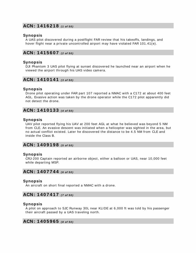
ACN: 1416218 (1 of 50)
Synopsis A UAS pilot discovered during a postflight FAR review that his takeoffs, landings, and
hover flight near a private uncontrolled airport may have violated FAR 101.41(e).
ACN: 1415607 (2 of 50)
Synopsis DJI Phantom 3 UAS pilot flying at sunset discovered he launched near an airport when he
viewed the airport through his UAS video camera.
ACN: 1410141 (3 of 50)
Synopsis Drone pilot operating under FAR part 107 reported a NMAC with a C172 at about 400 feet
AGL. Evasive action was taken by the drone operator while the C172 pilot apparently did
not detect the drone.
ACN: 1410133 (4 of 50)
Synopsis UAV pilot reported flying his UAV at 200 feet AGL at what he believed was beyond 5 NM
from CLE. An evasive descent was initiated when a helicopter was sighted in the area, but
no actual conflict existed. Later he discovered the distance to be 4.5 NM from CLE and
inside the Class B.
ACN: 1409198 (5 of 50)
Synopsis CRJ-200 Captain reported an airborne object, either a balloon or UAS, near 10,000 feet
while departing MSP.
ACN: 1407744 (6 of 50)
Synopsis An aircraft on short final reported a NMAC with a drone.
ACN: 1407417 (7 of 50)
Synopsis A pilot on approach to SJC Runway 30L near KLIDE at 6,000 ft was told by his passenger
their aircraft passed by a UAS traveling north.
ACN: 1405965 (8 of 50)
Synopsis A UAS pilot discovered after his flight that a nearby TFR had been expanded to include the
area of his previous operation.
ACN: 1405192 (9 of 50)
Synopsis DA20 instructor pilot reported a NMAC with a UAV east of ROA at 3000 feet. No evasive
action was required.
ACN: 1402826 (10 of 50)
Synopsis Helicopter pilot reported a UAV in his path on short final to a helipad. The UAV pilot
maneuvered away before the helicopter pilot could and was not seen again.
ACN: 1400261 (11 of 50)
Synopsis UAS pilot, operating legally near JFK after filing a flight plan and NOTAM for the flight, was
approached by a law enforcement helicopter. The pilot landed the UAV to avoid airborne
conflict then cancelled his flight after discussions with authorities.
ACN: 1398838 (12 of 50)
Synopsis UAV pilot reported going to the FAA UAV waiver website and completing the information
required for a Class D airspace waiver then operating his UAV in Class D as planned. Later
they learned that a response from the FAA was required before conducting such flights.
ACN: 1398214 (13 of 50)
Synopsis A319 flight crew reported sighting a UAV below and to the left of their aircraft while
descending through 7000 feet on the ROBUC2 arrival to BOS.
ACN: 1398198 (14 of 50)
Synopsis CRJ-900 First Officer reported sighting a UAV at 8000 feet near DREMS on the MILTON4
Arrival to LGA. No evasive action was taken, but the UAV passed within 75 feet of the
aircraft.
ACN: 1396916 (15 of 50)
Synopsis
Tower Controller reported a UAV landed and was taxiing off the runway. The Controller
cleared the next aircraft for departure then noticed the UAV may not be completely clear
of the runway. The Controller canceled the takeoff clearance, sees the UAV moving, and
says disregard. The aircraft departing advised they were aborting departure.
ACN: 1395951 (16 of 50)
Synopsis A UAS operator reported registering under FAR part 107 as a recreational operator instead
of a commercial operator. After reviewing an FAA webinar on part 107 he realized his error
and corrected it.
ACN: 1394042 (17 of 50)
Synopsis A DJI Phantom UAS pilot launched after checking diligently for TFR and controlled
airspace. However, after takeoff his DJI phone app alerted his aircraft proximity to SLC
Class B. The UAS flight was aborted.
ACN: 1392486 (18 of 50)
Synopsis Denver Center Controller reported of miscommunication and a lack of communication with
a UAV pilot. The Controller was advised of a special request in which was not valid. The
Operations Manager advised the Controller of what needed to be done.
ACN: 1391850 (19 of 50)
Synopsis UAS pilot reported inadvertently flying their UAS 0.2 NM inside Class D airspace reaching
about 60 ft AGL during aerial video photography.
ACN: 1391065 (20 of 50)
Synopsis PA-28 instructor pilot reported a government helicopter flew through the CTAF VFR pattern
with a PA-28 and UAS in the pattern. The UAS had to change course to avoid the
helicopter, but that put it in conflict with the PA-28. Both training aircraft took evasive
action, but the helicopter pilot apparently did not.
ACN: 1390632 (21 of 50)
Synopsis A319 Captain on approach to ORD Runway 28C at 2,400 feet reported a UAV at 3,000 feet
one mile prior to SEIKA.
ACN: 1390389 (22 of 50)
Synopsis Helicopter pilot flying at 2,500 ft near 4G4 airport at night reported sighting two lighted
UAVs at his altitude so he climbed to 3,500 ft.
ACN: 1390317 (23 of 50)
Synopsis B777 Captain reported sighting a UAV about 1500 feet below his aircraft while on
approach to ORD Runway 28C.
ACN: 1390151 (24 of 50)
Synopsis PA28 instructor pilot reported that a miniature airport for model aircraft is located 1.7 NM
SW of the HMT airport and one of the aircraft came in conflict with them nearby the RC
strip.
ACN: 1390011 (25 of 50)
Synopsis C172 instructor pilot reported sighting a drone at 1600 feet during arrival to SFB. Evasive
action was taken.
ACN: 1389549 (26 of 50)
Synopsis UAV pilot reported discovering after the fact that his aircraft overflew people at low
altitude during a cinematography flight under part 107.
ACN: 1389014 (27 of 50)
Synopsis A UAS pilot realized after a flight over the Horseshoe Falls portion of Niagara Falls that he
may have inadvertently flown into Canadian Airspace. Also, the UAS postflight altitude
indicated greater than 400 ft because the 167 ft waterfall drop off made the aircraft
appear higher than the preflight calibrated altitude.
ACN: 1388373 (28 of 50)
Synopsis A UAS pilot was notified by an Airport Manager via email that his UAS had been flown
within 5 NM of the airport.
ACN: 1387544 (29 of 50)
Synopsis
CE550 Captain experienced a NMAC with a UAV while departing MDW Runway 22L at 400
feet AGL.
ACN: 1387105 (30 of 50)
Synopsis A C150 pilot at 7,400 ft reported a near miss with what appeared to be a camera carrying
drone.
ACN: 1386746 (31 of 50)
Synopsis UAV pilot discovered after the fact that he flew within 4 NM of a private airport. He
believes that if the FAA is going to require notification to private airports a source of
contact information needs to be available. There does not seem to be a good way to find
contact information for private airports.
ACN: 1386058 (32 of 50)
Synopsis A MQ-9 UAV pilot reported his aircraft's preprogrammed track near the Canadian border
malfunctioned and the aircraft entered Canadian airspace. The aircraft's manual mode was
activated to depart Canada and a new preprogrammed track built further from the border.
ACN: 1383510 (33 of 50)
Synopsis A small aircraft pilot reported a close encounter with a UAV. He took immediate evasive
action and avoided a collision with the UAV.
ACN: 1382762 (34 of 50)
Synopsis A UAS pilot employed by a university reported being confronted by a passerby on school
property which caused a distraction. The reporter was concerned about the ability to
maintain the "sterile cockpit" policy when operating in open and public areas.
ACN: 1381776 (35 of 50)
Synopsis A helicopter pilot conducting a pipeline survey had a near miss with a UAS at 650 ft and
about 10 NM from an airport. ATC had no listed activity for that time period.
ACN: 1379975 (36 of 50)
Synopsis
C172 instructor pilot reported taking evasive action from a medium sized UAS with a
transponder which ATC observed. Reporter mentioned appeared to be a military aircraft
because no cockpit windscreen was visible as it passed overhead.
ACN: 1374413 (37 of 50)
Synopsis C172 instructor pilot reported sighting two UAV's on the same day over CON airport with
one at 1400 feet the other at 3000 feet.
ACN: 1372635 (38 of 50)
Synopsis PA28 instructor pilot reported a NMAC with a drone at 2000 feet MSL while on final
approach to IAG Runway 24.
ACN: 1370944 (39 of 50)
Synopsis BAE125 Captain reported being informed by ATC of a drone in the vicinity of the EWR ILS
Runway 04R before sighting it 500 feet to the right of the localizer.
ACN: 1370646 (40 of 50)
Synopsis UAV pilot conducting a mapping flight of FDW Runway 4 reported a low battery light and a
quick return to Runway 4 using CTAF procedures with a hand held VHF radio. A Bonanza
announced departing Runway 22, but does not acknowledge the UAV pilot. Evasive action
was taken by the UAV pilot.
ACN: 1370512 (41 of 50)
Synopsis EMB145 flight crew reported a possible drone sighting at 3,000 feet over DOOGY on
approach to ORD Runway 9L. A TCAS RA was generated to, "Monitor Vertical Speed" for
the traffic 500 feet below.
ACN: 1369666 (42 of 50)
Synopsis The pilot of a single engine transport aircraft reported seeing a UAV while on final
approach to PHX Runway 25L. No evasive action was required and, after reporting the
sighting to the Tower, he landed without incident.
ACN: 1369662 (43 of 50)
Synopsis Air carrier Captain reported a UAS 1 mile south of ORD Runway 27L at 1,300 ft on a 2.5
mile final.
ACN: 1368165 (44 of 50)
Synopsis Air carrier Captain reported that the First Officer saw a UAS off the aircraft's left on
approach to LAX. The Captain did not see it.
ACN: 1367986 (45 of 50)
Synopsis Air carrier Captain reported a near miss with a UAV at 5,000 ft over Pleasanton, CA.
ACN: 1367012 (46 of 50)
Synopsis A pilot reported a near miss with a UAV at 1000 feet AGL while on downwind departing
3CK.
ACN: 1365558 (47 of 50)
Synopsis An air carrier crew was notified by EWR Tower about an earlier UAS sighting. They also
detected the UAS at about 420 feet, but the craft's details were difficult to determine.
ACN: 1365320 (48 of 50)
Synopsis An EMB-175 Captain reported being advised by a Flight Attendant that a passenger
witnessed a dark grey, spherically shaped UAS three feet long flew near their aircraft's
wingtip at some point during departure.
ACN: 1364983 (49 of 50)
Synopsis Light Jet Air taxi First Officer reported a near miss with a UAV at 7,000 ft while flying a
straight in visual approach to SBY Runway 14. TRACON Controller showed no interest in
the event.
ACN: 1364948 (50 of 50)
Synopsis

A DJI Inspire 1 Pro UAS owner lost communication with the aircraft which then did not
return "home" but hit a tall building destroying the UAS and breaking a window 25 stories
up.

Report Narratives
ACN: 1416218 (1 of 50)
Time / Day
Date : 201701
Local Time Of Day : 1201-1800
Place
Locale Reference.Airport : ZZZ.Airport
State Reference : US
Relative Position.Distance.Nautical Miles : 4
Altitude.AGL.Single Value : 100
Environment
Flight Conditions : VMC
Weather Elements / Visibility.Visibility : 20
Light : Daylight
Ceiling.Single Value : 10000
Aircraft
Reference : X
Aircraft Operator : Personal
Make Model Name : UAV - Unpiloted Aerial Vehicle
Operating Under FAR Part.Other
Flight Plan : None
Mission : Personal
Flight Phase : Cruise
Route In Use : None
Airspace.Class G : ZZZ
Person
Reference : 1
Location Of Person : Gate / Ramp / Line
Reporter Organization : Personal
Function.Flight Crew : Single Pilot
Qualification.Flight Crew : Instrument
Qualification.Flight Crew : Air Transport Pilot (ATP)
Qualification.Flight Crew : Flight Instructor
Qualification.Flight Crew : Multiengine
Experience.Flight Crew.Total : 14000
Experience.Flight Crew.Last 90 Days : 150
ASRS Report Number.Accession Number : 1416218
Human Factors : Situational Awareness
Human Factors : Confusion
Events
Anomaly.ATC Issue : All Types
Anomaly.Deviation - Procedural : Published Material / Policy
Anomaly.Deviation - Procedural : FAR
Detector.Person : Flight Crew
When Detected : Routine Inspection
Result.General : None Reported / Taken
Assessments
Contributing Factors / Situations : Human Factors
Contributing Factors / Situations : Procedure
Primary Problem : Human Factors
Narrative: 1
After thorough review of new Part 107 I believed that no notification of uncontrolled
airports was required. I reviewed charts and knew I was well away from B, C, D and E
airspace and solidly within Class G. No people were around and no aircraft were anywhere
to be seen. I did a few takeoffs and landings and hovering at low altitude. Only after later
reading online blogs and further review did I understand that my operation had probably
been under Part 101 and that prior notification had been required. Some parts of the FAA
website are clearer than others. On the FAA.gov website I saw that no pilot license was
required for recreational drone flying. And I reviewed the airspace requirements on the
FAA summary of Part 107. I had registered and marked my drone with my UAS Certificate
number.
Synopsis
A UAS pilot discovered during a postflight FAR review that his takeoffs, landings, and
hover flight near a private uncontrolled airport may have violated FAR 101.41(e).
ACN: 1415607 (2 of 50)
Time / Day
Date : 201601
Local Time Of Day : 1201-1800
Place
Locale Reference.Airport : OCH.Airport
State Reference : TX
Altitude.AGL.Single Value : 350
Environment
Flight Conditions : VMC
Light : Dusk
Aircraft
Reference : X
Aircraft Operator : Personal
Make Model Name : UAV - Unpiloted Aerial Vehicle
Operating Under FAR Part.Other
Flight Plan : None
Mission : Personal
Flight Phase : Cruise
Airspace.Class G : OCH
Person
Reference : 1
Location Of Person : Gate / Ramp / Line
Reporter Organization : Personal
Function.Flight Crew : Single Pilot
Experience.Flight Crew.Total : 0.5
ASRS Report Number.Accession Number : 1415607
Human Factors : Situational Awareness
Human Factors : Confusion
Events
Anomaly.Airspace Violation : All Types
Anomaly.Deviation - Procedural : FAR
Anomaly.Deviation - Procedural : Published Material / Policy
Detector.Person : Flight Crew
When Detected : In-flight
Result.Flight Crew : Became Reoriented
Result.Flight Crew : Exited Penetrated Airspace
Result.Flight Crew : Took Evasive Action
Assessments
Contributing Factors / Situations : Human Factors
Contributing Factors / Situations : Procedure
Primary Problem : Human Factors
Narrative: 1
In Nacogdoches County Texas, I was mistakenly piloting an UAV in class G air space. I was
flying at approximately 350 ft AGL taking photography of the sunset off the treetops. I
noticed an airstrip in the distance and immediately grounded the aircraft. I researched my
location and realized I am within 5 miles of Mangham Jr. Regional Airport in Nacogdoches,
TX.
I assumed Angelina county airport was the only airport in the area. I will make every
effort to familiarize myself with local airspace with sectional charts prior to flying. I will
also make contact with ATC in controlled airspace prior to flying.
Synopsis
DJI Phantom 3 UAS pilot flying at sunset discovered he launched near an airport when he
viewed the airport through his UAS video camera.
ACN: 1410141 (3 of 50)
Time / Day
Date : 201612
Local Time Of Day : 0601-1200
Place
Locale Reference.Airport : BTR.Airport
State Reference : LA
Relative Position.Distance.Nautical Miles : 15
Altitude.AGL.Single Value : 375
Environment
Flight Conditions : VMC
Weather Elements / Visibility.Visibility : 10
Light : Daylight
Ceiling.Single Value : 18000
Aircraft : 1
Reference : X
ATC / Advisory.CTAF : ZZZ
Aircraft Operator : Corporate
Make Model Name : UAV - Unpiloted Aerial Vehicle
Operating Under FAR Part.Other
Flight Plan : VFR
Mission : Utility
Flight Phase : Cruise
Route In Use : None
Airspace.Class G : ZHU
Aircraft : 2
Reference : Y
Make Model Name : Skyhawk 172/Cutlass 172
Operating Under FAR Part : Part 91
Mission : Utility
Flight Phase : Cruise
Airspace.Class G : ZHU
Person
Reference : 1
Location Of Person : Hangar / Base
Reporter Organization : Corporate
Function.Flight Crew : Pilot Flying
Qualification.Flight Crew : Student
Experience.Flight Crew.Total : 60
Experience.Flight Crew.Last 90 Days : 40
Experience.Flight Crew.Type : 25
ASRS Report Number.Accession Number : 1410141
Human Factors : Situational Awareness
Events
Anomaly.Conflict : NMAC
Detector.Person : Flight Crew
Miss Distance.Horizontal : 350
Miss Distance.Vertical : 75
When Detected : In-flight
Result.Flight Crew : Took Evasive Action
Result.Flight Crew : Landed As Precaution
Assessments
Contributing Factors / Situations : Airspace Structure
Contributing Factors / Situations : Human Factors
Primary Problem : Human Factors
Narrative: 1
I was operating a drone under Part 107 collecting aerial photographs of a timber harvest
area. I had filed a UAS operating area report with Flight Services in an effort to warn air
traffic I would be operating in the area, the altitude I would be at, and the exact times of
operation. We also had a hand held VHF aviation radio turned on and operating on 122.9
frequency. A visual observer was also on site and fully briefed.
Approximately 15 SM SW of BTR the drone was operating at 375 ft AGL flying a grid
pattern over [area we were to photograph]. I was facing south maintaining visual contact
with the drone, my visual observer was facing north in my blind spot, the drone was 692 ft
laterally from my location. The visual observer yelled out an aircraft sighting report, I
turned to look and saw a Cessna 172 flying at approximately the same altitude as the
drone on what appeared to be a collision course approximately .4-.25 miles from the
drones position. The Cessna pilot did not seem to see the drone, he was operating at or
below 500 ft in my estimation, and was obscured from view on the ground behind a tree
line until he cleared the trees. We did not hear his engine until after he cleared the trees. I
immediately took evasive action, reducing done altitude to ground level as fast as possible
(cut the engines). The drone crash landed and did not visibly impact the Cessna, the
Cessna continued on without visible deviation from its flight route. It is my belief that the
Cessna was operating as a pipeline patrol aircraft since a pipeline was in close proximity
and the pilot was at such a low altitude.
This was a VERY high potential near miss. While I was able to see and avoid the Cessna it
is debatable if he was able to see my drone. If the Cessna pilot had filed a flight plan or
called flight services I feel he should have had ample warning of my intended area of
operation and flight level. As a licensed sUAS operator and a current student pilot I can
see conflicts between low flying aircraft and drones outside controlled airspace becoming
more common, especially in cases like my experience. There needs to be a better way to
freely communicate drone activities with pilots and more emphasis given to pilots to check
UAS operating areas before they fly, especially when flying below or near 400 ft AGL.
Synopsis
Drone pilot operating under FAR part 107 reported a NMAC with a C172 at about 400 feet
AGL. Evasive action was taken by the drone operator while the C172 pilot apparently did
not detect the drone.
ACN: 1410133 (4 of 50)
Time / Day
Date : 201612
Local Time Of Day : 1201-1800
Place
Locale Reference.Airport : CLE.Airport
State Reference : OH
Relative Position.Distance.Nautical Miles : 4.5
Altitude.AGL.Single Value : 200
Environment
Flight Conditions : VMC
Weather Elements / Visibility.Visibility : 10
Light : Daylight
Ceiling.Single Value : 7000
Aircraft : 1
Reference : X
Aircraft Operator : Personal
Make Model Name : UAV - Unpiloted Aerial Vehicle
Operating Under FAR Part.Other
Flight Plan : None
Mission : Personal
Flight Phase : Cruise
Route In Use : None
Airspace.Class B : CLE
Aircraft : 2
Reference : Y
ATC / Advisory.Tower : CLE
Make Model Name : Helicopter
Crew Size.Number Of Crew : 1
Flight Phase : Cruise
Airspace.Class B : CLE
Person
Reference : 1
Location Of Person : Hangar / Base
Reporter Organization : Personal
Function.Flight Crew : Pilot Flying
Qualification.Flight Crew : Private
Experience.Flight Crew.Total : 61
Experience.Flight Crew.Last 90 Days : 3
ASRS Report Number.Accession Number : 1410133
Human Factors : Situational Awareness
Events
Anomaly.Airspace Violation : All Types
Anomaly.Conflict : Airborne Conflict
Anomaly.Deviation - Procedural : FAR
Detector.Person : Ground Personnel
Miss Distance.Horizontal : 500
Miss Distance.Vertical : 800
When Detected : In-flight
Result.Flight Crew : Took Evasive Action
Result.Flight Crew : Landed As Precaution
Assessments
Contributing Factors / Situations : Human Factors
Primary Problem : Human Factors
Narrative: 1
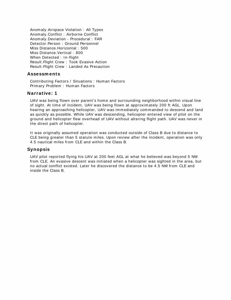
UAV was being flown over parent's home and surrounding neighborhood within visual line
of sight. At time of incident, UAV was being flown at approximately 200 ft AGL. Upon
hearing an approaching helicopter, UAV was immediately commanded to descend and land
as quickly as possible. While UAV was descending, helicopter entered view of pilot on the
ground and helicopter flew overhead of UAV without altering flight path. UAV was never in
the direct path of helicopter.
It was originally assumed operation was conducted outside of Class B due to distance to
CLE being greater than 5 statute miles. Upon review after the incident, operation was only
4.5 nautical miles from CLE and within the Class B.
Synopsis
UAV pilot reported flying his UAV at 200 feet AGL at what he believed was beyond 5 NM
from CLE. An evasive descent was initiated when a helicopter was sighted in the area, but
no actual conflict existed. Later he discovered the distance to be 4.5 NM from CLE and
inside the Class B.
ACN: 1409198 (5 of 50)
Time / Day
Date : 201612
Local Time Of Day : 1201-1800
Place
Locale Reference.Airport : MSP.Airport
State Reference : MN
Altitude.MSL.Single Value : 10000
Environment
Light : Daylight
Aircraft : 1
Reference : X
ATC / Advisory.TRACON : M98
Aircraft Operator : Air Carrier
Make Model Name : Regional Jet 200 ER/LR (CRJ200)
Crew Size.Number Of Crew : 2
Operating Under FAR Part : Part 121
Flight Plan : IFR
Mission : Passenger
Nav In Use : FMS Or FMC
Flight Phase : Climb
Airspace.Class E : ZMP
Aircraft : 2
Reference : Y
Make Model Name : UAV - Unpiloted Aerial Vehicle
Flight Phase : Cruise
Airspace.Class E : ZMP
Person
Reference : 1
Location Of Person.Aircraft : X
Location In Aircraft : Flight Deck
Reporter Organization : Air Carrier
Function.Flight Crew : Pilot Not Flying
Function.Flight Crew : Captain
Qualification.Flight Crew : Air Transport Pilot (ATP)
ASRS Report Number.Accession Number : 1409198
Human Factors : Distraction
Human Factors : Workload
Events
Anomaly.Conflict : Airborne Conflict
Anomaly.Deviation - Track / Heading : All Types
Detector.Person : Flight Crew
When Detected : In-flight
Result.Flight Crew : Became Reoriented
Result.Flight Crew : Returned To Clearance
Result.Flight Crew : Took Evasive Action
Result.Air Traffic Control : Issued Advisory / Alert
Assessments
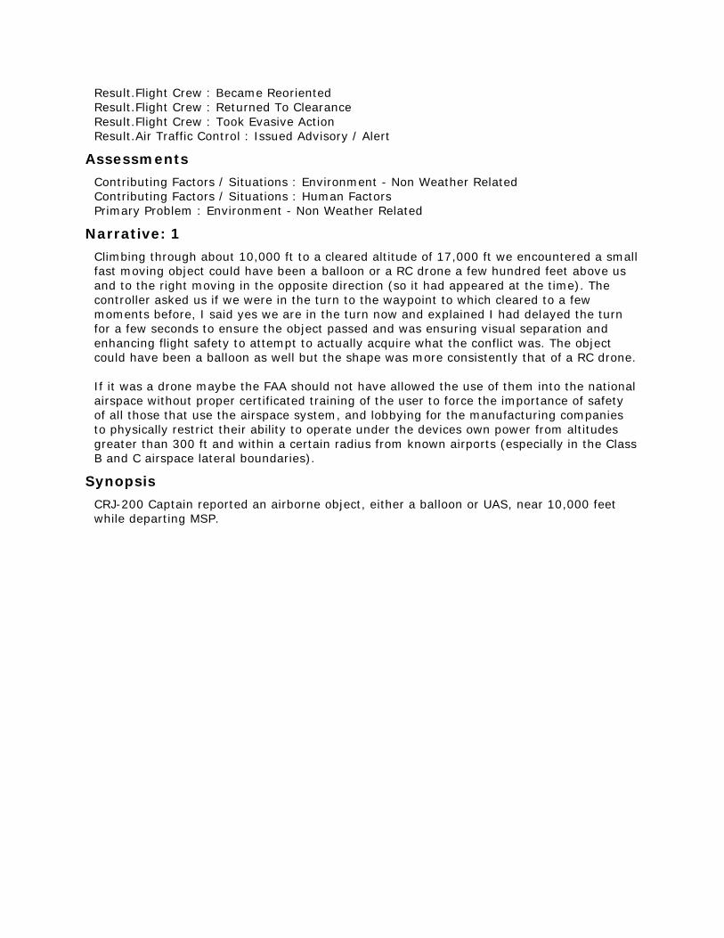
Contributing Factors / Situations : Environment - Non Weather Related
Contributing Factors / Situations : Human Factors
Primary Problem : Environment - Non Weather Related
Narrative: 1
Climbing through about 10,000 ft to a cleared altitude of 17,000 ft we encountered a small
fast moving object could have been a balloon or a RC drone a few hundred feet above us
and to the right moving in the opposite direction (so it had appeared at the time). The
controller asked us if we were in the turn to the waypoint to which cleared to a few
moments before, I said yes we are in the turn now and explained I had delayed the turn
for a few seconds to ensure the object passed and was ensuring visual separation and
enhancing flight safety to attempt to actually acquire what the conflict was. The object
could have been a balloon as well but the shape was more consistently that of a RC drone.
If it was a drone maybe the FAA should not have allowed the use of them into the national
airspace without proper certificated training of the user to force the importance of safety
of all those that use the airspace system, and lobbying for the manufacturing companies
to physically restrict their ability to operate under the devices own power from altitudes
greater than 300 ft and within a certain radius from known airports (especially in the Class
B and C airspace lateral boundaries).
Synopsis
CRJ-200 Captain reported an airborne object, either a balloon or UAS, near 10,000 feet
while departing MSP.
ACN: 1407744 (6 of 50)
Time / Day
Date : 201612
Local Time Of Day : 1201-1800
Place
Locale Reference.Airport : SEA.Airport
State Reference : WA
Altitude.AGL.Single Value : 1300
Environment
Flight Conditions : VMC
Aircraft : 1
Reference : X
ATC / Advisory.Tower : SEA
Aircraft Operator : Air Carrier
Make Model Name : Large Transport
Crew Size.Number Of Crew : 2
Operating Under FAR Part : Part 121
Flight Plan : IFR
Mission : Passenger
Flight Phase : Final Approach
Airspace.Class B : SEA
Aircraft : 2
ATC / Advisory.Tower : SEA
Make Model Name : UAV - Unpiloted Aerial Vehicle
Airspace.Class B : SEA
Person
Reference : 1
Location Of Person.Aircraft : X
Location In Aircraft : Flight Deck
Reporter Organization : Air Carrier
Function.Flight Crew : First Officer
Function.Flight Crew : Pilot Not Flying
Qualification.Flight Crew : Air Transport Pilot (ATP)
Experience.Flight Crew.Last 90 Days : 200
Experience.Flight Crew.Type : 1802
ASRS Report Number.Accession Number : 1407744
Human Factors : Situational Awareness
Events
Anomaly.Conflict : NMAC
Detector.Person : Flight Crew
When Detected : In-flight
Assessments
Contributing Factors / Situations : Aircraft
Contributing Factors / Situations : Airport
Primary Problem : Aircraft
Narrative: 1
On short final we encountered a drone approximately 1300 feet AGL just to the right of the
runway centerline. I was the pilot monitoring and the flight operated normally up to the
final approach fix. The Captain Pilot Flying (PF) had just directed gear down, full flaps just
prior to the encounter. I saw out of the corner of my eye a dark object just the right of the
aircraft, but perceived it to be either a reflection (the sun was to our left and behind a
little), or possibly a balloon. I initially dismissed it, until the aircraft in front of us began
talking to tower about a drone on short final at approximately 1000 feet. I estimate the
drone was 2-3 feet in diameter, dark in color, and roughly 30-50 feet right and slightly
above our position on final. We reported our encounter to Tower after landing.
Synopsis
An aircraft on short final reported a NMAC with a drone.
ACN: 1407417 (7 of 50)
Time / Day
Date : 201612
Local Time Of Day : 1201-1800
Place
Locale Reference.Airport : SJC.Airport
State Reference : CA
Relative Position.Angle.Radial : 126
Relative Position.Distance.Nautical Miles : 16
Altitude.MSL.Single Value : 6000
Environment
Flight Conditions : VMC
Weather Elements / Visibility.Visibility : 30
Light : Daylight
Aircraft : 1
Reference : X
ATC / Advisory.TRACON : NCT
Aircraft Operator : Personal
Make Model Name : Small Transport
Crew Size.Number Of Crew : 1
Operating Under FAR Part : Part 91
Flight Plan : IFR
Mission : Passenger
Nav In Use : FMS Or FMC
Nav In Use : GPS
Nav In Use.Localizer/Glideslope/ILS : Runway 30L
Flight Phase : Initial Approach
Airspace.Class E : ZOA
Aircraft : 2
Reference : Y
Make Model Name : UAV - Unpiloted Aerial Vehicle
Flight Phase : Cruise
Airspace.Class E : ZOA
Person
Reference : 1
Location Of Person.Aircraft : X
Location In Aircraft : Flight Deck
Reporter Organization : Personal
Function.Flight Crew : Pilot Flying
Function.Flight Crew : Single Pilot
Qualification.Flight Crew : Sea
Qualification.Flight Crew : Air Transport Pilot (ATP)
Qualification.Flight Crew : Multiengine
Qualification.Flight Crew : Instrument
Qualification.Flight Crew : Rotorcraft
Experience.Flight Crew.Total : 3110
Experience.Flight Crew.Last 90 Days : 35
Experience.Flight Crew.Type : 880
ASRS Report Number.Accession Number : 1407417
Human Factors : Workload
Human Factors : Distraction
Events
Anomaly.Conflict : Airborne Conflict
Anomaly.Deviation - Procedural : Published Material / Policy
Anomaly.Deviation - Procedural : FAR
Detector.Person : Passenger
Miss Distance.Horizontal : 600
Miss Distance.Vertical : 0
When Detected : In-flight
Result.General : None Reported / Taken
Assessments
Contributing Factors / Situations : Human Factors
Contributing Factors / Situations : Procedure
Primary Problem : Procedure
Narrative: 1
Adult passenger (non-pilot) in co-pilot seat reported to me that a small drone passed by
our aircraft on the starboard side (the drone was heading in a northerly direction).
Distance was uncertain. No report of drone was heard while monitoring ATC.
Synopsis
A pilot on approach to SJC Runway 30L near KLIDE at 6,000 ft was told by his passenger
their aircraft passed by a UAS traveling north.
ACN: 1405965 (8 of 50)
Time / Day
Date : 201611
Local Time Of Day : 0601-1200
Place
Locale Reference.Airport : ZZZ.Airport
State Reference : US
Altitude.AGL.Single Value : 144
Environment
Flight Conditions : VMC
Light : Daylight
Aircraft
Reference : X
Aircraft Operator : Personal
Make Model Name : UAV - Unpiloted Aerial Vehicle
Operating Under FAR Part.Other
Flight Plan : None
Mission : Utility
Flight Phase : Cruise
Airspace.Class G : ZZZ
Airspace.TFR : FIRE
Person
Reference : 1
Location Of Person : Hangar / Base
Reporter Organization : Personal
Function.Flight Crew : Single Pilot
Qualification.Flight Crew : Private
Experience.Flight Crew.Total : 120
Experience.Flight Crew.Last 90 Days : 2
Experience.Flight Crew.Type : 30
ASRS Report Number.Accession Number : 1405965
Events
Anomaly.Airspace Violation : All Types
Anomaly.Deviation - Procedural : FAR
Detector.Person : Flight Crew
When Detected : Routine Inspection
Result.General : None Reported / Taken
Assessments
Contributing Factors / Situations : Environment - Non Weather Related
Contributing Factors / Situations : Procedure
Primary Problem : Procedure
Narrative: 1
I performed an unmanned aircraft operation lasting 4 minutes and 46 seconds reaching a
maximum altitude of 144 feet AGL travelling a maximum distance of 800 ft. The purpose
of the flight was to survey damage to our second residence. Prior to travelling to the area,
I had checked for a TFR and found one active in the area with a 5 NM radius. My planned
area of flight was approximately 2 NM outside of the published TFR map and not within the
vicinity of any active firefighting activities as they had moved back into the area. After
completing the flight and returning home, I was self-debriefing and discovered the TFR
had been expanded to cover the area of my operation just prior to my flight. Since no
firefighting or emergency response activities were occurring in the area at the time of the
flight, I had no reason to believe the original TFR was not still valid. Due to the lack of
cellular data service in the area, I would not have been able to access updated TFR
information prior to the operation. No conflicts or accidents occurred as a result of my
operation.
Synopsis
A UAS pilot discovered after his flight that a nearby TFR had been expanded to include the
area of his previous operation.
ACN: 1405192 (9 of 50)
Time / Day
Date : 201611
Local Time Of Day : 1201-1800
Place
Locale Reference.Airport : ROA.Airport
State Reference : VA
Relative Position.Angle.Radial : 090
Relative Position.Distance.Nautical Miles : 4.8
Altitude.MSL.Single Value : 3000
Environment
Flight Conditions : VMC
Weather Elements / Visibility.Visibility : 10
Light : Dusk
Ceiling.Single Value : 5000
Aircraft : 1
Reference : X
ATC / Advisory.Tower : ROA
Aircraft Operator : FBO
Make Model Name : DA20 Undifferentiated
Crew Size.Number Of Crew : 2
Operating Under FAR Part : Part 91
Flight Plan : VFR
Mission : Training
Flight Phase : Cruise
Route In Use : None
Airspace.Class C : ROA
Aircraft : 2
Reference : Y
Make Model Name : UAV - Unpiloted Aerial Vehicle
Flight Phase : Cruise
Airspace.Class C : ROA
Person
Reference : 1
Location Of Person.Aircraft : X
Location In Aircraft : Flight Deck
Reporter Organization : FBO
Function.Flight Crew : Instructor
Function.Flight Crew : Pilot Not Flying
Qualification.Flight Crew : Instrument
Qualification.Flight Crew : Commercial
Qualification.Flight Crew : Flight Instructor
Experience.Flight Crew.Total : 4600
Experience.Flight Crew.Last 90 Days : 130
Experience.Flight Crew.Type : 150
ASRS Report Number.Accession Number : 1405192
Events
Anomaly.Conflict : NMAC
Detector.Person : Flight Crew
Miss Distance.Horizontal : 200
Miss Distance.Vertical : 100
When Detected : In-flight
Result.General : None Reported / Taken
Assessments
Contributing Factors / Situations : Human Factors
Primary Problem : Human Factors
Narrative: 1
Flight departed Runway 06 at ROA. Initial heading was 070 with a climb to our requested
VFR altitude. A few minutes later, ROA Tower cleared us on course (south). After leveling
at 3000 feet MSL, we observed what appeared to be a small unmanned aircraft of
moderate size (3 feet or less), possibly a quadcopter approximately 100 feet above and
200 feet to our left (east). It appeared to be maneuvering but not converging with us. We
continued on our heading and altitude and informed Tower of the sighting.
Synopsis
DA20 instructor pilot reported a NMAC with a UAV east of ROA at 3000 feet. No evasive
action was required.

ACN: 1402826 (10 of 50)
Time / Day
Date : 201611
Place
Locale Reference.Airport : ATL.Airport
State Reference : GA
Altitude.AGL.Single Value : 500
Environment
Flight Conditions : VMC
Light : Daylight
Aircraft : 1
Reference : X
ATC / Advisory.CTAF : ZZZ
Aircraft Operator : Air Taxi
Make Model Name : Helicopter
Crew Size.Number Of Crew : 1
Operating Under FAR Part : Part 135
Flight Plan : VFR
Mission : Passenger
Flight Phase : Final Approach
Route In Use : Visual Approach
Airspace.Class E : A80
Aircraft : 2
Reference : Y
Make Model Name : UAV - Unpiloted Aerial Vehicle
Flight Phase : Cruise
Airspace.Class E : A80
Person
Reference : 1
Location Of Person.Aircraft : X
Location In Aircraft : Flight Deck
Reporter Organization : Air Taxi
Function.Flight Crew : Single Pilot
Function.Flight Crew : Pilot Flying
Qualification.Flight Crew : Commercial
Qualification.Flight Crew : Rotorcraft
Qualification.Flight Crew : Instrument
ASRS Report Number.Accession Number : 1402826
Events
Anomaly.Conflict : NMAC
Detector.Person : Flight Crew
Miss Distance.Horizontal : 150
Miss Distance.Vertical : 100
When Detected : In-flight
Result.General : None Reported / Taken
Assessments
Contributing Factors / Situations : Human Factors
Primary Problem : Human Factors
Narrative: 1
Flying into [a helicopter pad in Atlanta] on short final we encountered a drone on our
direct flight path for landing. I announced to crew I was taking evasive action, before I
could initiate evasive action the drone dropped down and to the right out of our flight
path. It was not seen again.
Synopsis
Helicopter pilot reported a UAV in his path on short final to a helipad. The UAV pilot
maneuvered away before the helicopter pilot could and was not seen again.
ACN: 1400261 (11 of 50)
Time / Day
Date : 201611
Local Time Of Day : 0601-1200
Place
Locale Reference.Airport : JFK.Airport
State Reference : NY
Altitude.AGL.Single Value : 200
Environment
Flight Conditions : VMC
Weather Elements / Visibility.Visibility : 10
Light : Daylight
Ceiling.Single Value : 12000
Aircraft : 1
Reference : X
ATC / Advisory.Tower : JFK
Aircraft Operator : Personal
Make Model Name : UAV - Unpiloted Aerial Vehicle
Operating Under FAR Part.Other
Mission : Personal
Flight Phase : Cruise
Route In Use : None
Airspace.Class B : JFK
Aircraft : 2
Reference : Y
ATC / Advisory.Tower : JFK
Aircraft Operator : Government
Make Model Name : Helicopter
Crew Size.Number Of Crew : 1
Operating Under FAR Part : Part 91
Flight Phase : Cruise
Airspace.Class B : JFK
Person
Reference : 1
Location Of Person : Hangar / Base
Reporter Organization : Personal
Function.Flight Crew : Single Pilot
Qualification.Flight Crew : Private
Experience.Flight Crew.Total : 750
Experience.Flight Crew.Last 90 Days : 30
Experience.Flight Crew.Type : 30
ASRS Report Number.Accession Number : 1400261
Human Factors : Communication Breakdown
Human Factors : Confusion
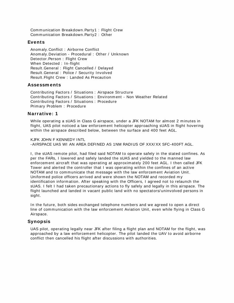
Communication Breakdown.Party1 : Flight Crew
Communication Breakdown.Party2 : Other
Events
Anomaly.Conflict : Airborne Conflict
Anomaly.Deviation - Procedural : Other / Unknown
Detector.Person : Flight Crew
When Detected : In-flight
Result.General : Flight Cancelled / Delayed
Result.General : Police / Security Involved
Result.Flight Crew : Landed As Precaution
Assessments
Contributing Factors / Situations : Airspace Structure
Contributing Factors / Situations : Environment - Non Weather Related
Contributing Factors / Situations : Procedure
Primary Problem : Procedure
Narrative: 1
While operating a sUAS in Class G airspace, under a JFK NOTAM for almost 2 minutes in
flight, UAS pilot noticed a law enforcement helicopter approaching sUAS in flight hovering
within the airspace described below, between the surface and 400 feet AGL.
KJFK JOHN F KENNEDY INTL
-AIRSPACE UAS WI AN AREA DEFINED AS 1NM RADIUS OF XXX/XX SFC-400FT AGL.
I, the sUAS remote pilot, had filed said NOTAM to operate safely in the stated confines. As
per the FARs, I lowered and safely landed the sUAS and yielded to the manned law
enforcement aircraft that was operating at approximately 200 feet AGL. I then called JFK
Tower and alerted the controller that I was operating within the confines of an active
NOTAM and to communicate that message with the law enforcement Aviation Unit.
Uniformed police officers arrived and were shown the NOTAM and recorded my
identification information. After speaking with the Officers, I agreed not to relaunch the
sUAS. I felt I had taken precautionary actions to fly safely and legally in this airspace. The
flight launched and landed in vacant public land with no spectators/uninvolved persons in
sight.
In the future, both sides exchanged telephone numbers and we agreed to open a direct
line of communication with the law enforcement Aviation Unit, even while flying in Class G
Airspace.
Synopsis
UAS pilot, operating legally near JFK after filing a flight plan and NOTAM for the flight, was
approached by a law enforcement helicopter. The pilot landed the UAV to avoid airborne
conflict then cancelled his flight after discussions with authorities.
ACN: 1398838 (12 of 50)
Time / Day
Date : 201609
Local Time Of Day : 1201-1800
Place
Locale Reference.Airport : ZZZ.Airport
State Reference : US
Altitude.AGL.Single Value : 200
Environment
Weather Elements / Visibility.Visibility : 10
Light : Daylight
Aircraft
Reference : X
Aircraft Operator : Personal
Make Model Name : UAV - Unpiloted Aerial Vehicle
Operating Under FAR Part.Other
Flight Plan : None
Mission : Personal
Flight Phase : Cruise
Route In Use : None
Airspace.Class D : ZZZ
Person
Reference : 1
Location Of Person : Hangar / Base
Reporter Organization : Personal
Function.Flight Crew : Pilot Flying
Function.Flight Crew : Single Pilot
Experience.Flight Crew.Total : 350
Experience.Flight Crew.Last 90 Days : 30
Experience.Flight Crew.Type : 150
ASRS Report Number.Accession Number : 1398838
Human Factors : Training / Qualification
Events
Anomaly.Airspace Violation : All Types
Anomaly.Deviation - Procedural : FAR
Detector.Person : Flight Crew
When Detected : Routine Inspection
Result.Flight Crew : Became Reoriented
Assessments
Contributing Factors / Situations : Human Factors
Contributing Factors / Situations : Procedure
Primary Problem : Human Factors
Narrative: 1
While operating a UAV under a part 107 license I may have flown into controlled airspace
without authorization. Prior to beginning a series of short flight(s) that took place [in
September], I went to the FAA UAV waiver website and completed the information
required for an airspace waiver allowing me to fly within Class D controlled airspace. I was
under the mistaken impression that authorization was granted upon the completion of the
online form and I could commence the flight(s). However, I later learned that it may take
up to 90 days to receive the requested authorization. Although I requested multiple COAs
under a 333 exemption almost a year ago and have made multiple "requests" for Class D
waivers recently none of these have been granted yet to my knowledge and therefore
several of my recent flights may have been made in Class D airspace without
authorization. However, all flights were at or below tree top level and in no circumstances
exceeded 200 ft AGL within at least 2 miles of an airport, they were conducted without
incident, and did not interfere with the operation of a manned aircraft in any way
whatsoever.
Synopsis
UAV pilot reported going to the FAA UAV waiver website and completing the information
required for a Class D airspace waiver then operating his UAV in Class D as planned. Later
they learned that a response from the FAA was required before conducting such flights.
ACN: 1398214 (13 of 50)
Time / Day
Date : 201610
Local Time Of Day : 0601-1200
Place
Locale Reference.Airport : BOS.Airport
State Reference : MA
Altitude.MSL.Single Value : 7000
Environment
Flight Conditions : VMC
Light : Daylight
Aircraft : 1
Reference : X
ATC / Advisory.TRACON : A90
Aircraft Operator : Air Carrier
Make Model Name : A319
Crew Size.Number Of Crew : 2
Operating Under FAR Part : Part 121
Flight Plan : IFR
Mission : Passenger
Nav In Use : FMS Or FMC
Nav In Use : GPS
Flight Phase : Initial Approach
Route In Use.STAR : ROBUC2
Airspace.Class E : A90
Aircraft : 2
Reference : Y
Make Model Name : UAV - Unpiloted Aerial Vehicle
Flight Phase : Cruise
Airspace.Class E : A90
Person : 1
Reference : 1
Location Of Person.Aircraft : X
Location In Aircraft : Flight Deck
Reporter Organization : Air Carrier
Function.Flight Crew : First Officer
Function.Flight Crew : Pilot Not Flying
Qualification.Flight Crew : Air Transport Pilot (ATP)
Experience.Flight Crew.Type : 420
ASRS Report Number.Accession Number : 1398214
Person : 2
Reference : 2
Location Of Person.Aircraft : X
Location In Aircraft : Flight Deck
Reporter Organization : Air Carrier
Function.Flight Crew : Pilot Flying
Function.Flight Crew : Captain
Qualification.Flight Crew : Air Transport Pilot (ATP)
Experience.Flight Crew.Type : 5266
ASRS Report Number.Accession Number : 1398222
Events
Anomaly.Conflict : Airborne Conflict
Detector.Person : Flight Crew
Miss Distance.Horizontal : 500
Miss Distance.Vertical : 1000
When Detected : In-flight
Result.General : None Reported / Taken
Assessments
Contributing Factors / Situations : Human Factors
Primary Problem : Human Factors
Narrative: 1
While descending through 7,000 feet between BEREI and BBOGG intersection on the
ROBUC2 STAR into BOS, the captain reported to me that he saw a silver and white colored
drone 1,000 feet below our aircraft and approximately 500 feet off our 8 o'clock position.
The sighting was reported to BOS Approach Control.
Narrative: 2
While on the ROBUC2 Arrival near the BEREI Intersection descending through 7000 feet, a
silver and white drone was sighted 500 feet laterally left and 1000 feet vertically below the
aircraft.
Synopsis
A319 flight crew reported sighting a UAV below and to the left of their aircraft while
descending through 7000 feet on the ROBUC2 arrival to BOS.
ACN: 1398198 (14 of 50)
Time / Day
Date : 201610
Local Time Of Day : 0601-1200
Place
Locale Reference.Airport : LGA.Airport
State Reference : NY
Altitude.MSL.Single Value : 8000
Environment
Flight Conditions : VMC
Light : Daylight
Aircraft : 1
Reference : X
ATC / Advisory.TRACON : N90
Aircraft Operator : Air Carrier
Make Model Name : Regional Jet 900 (CRJ900)
Crew Size.Number Of Crew : 2
Operating Under FAR Part : Part 121
Flight Plan : IFR
Mission : Passenger
Nav In Use : FMS Or FMC
Nav In Use : GPS
Flight Phase : Initial Approach
Route In Use.STAR : MILTON4
Airspace.Class E : N90
Aircraft : 2
Reference : Y
Make Model Name : UAV - Unpiloted Aerial Vehicle
Flight Phase : Cruise
Airspace.Class E : N90
Person
Reference : 1
Location Of Person.Aircraft : X
Location In Aircraft : Flight Deck
Reporter Organization : Air Carrier
Function.Flight Crew : First Officer
Function.Flight Crew : Pilot Flying
Qualification.Flight Crew : Air Transport Pilot (ATP)
ASRS Report Number.Accession Number : 1398198
Events
Anomaly.Conflict : NMAC
Detector.Person : Flight Crew
Miss Distance.Horizontal : 75
Miss Distance.Vertical : 0
When Detected : In-flight
Result.General : None Reported / Taken
Assessments
Contributing Factors / Situations : Human Factors
Primary Problem : Human Factors
Narrative: 1
Spotted a drone during turn from DREMS intersection to APPLE intersection at 8000 feet.
Silver drone, size of maybe a small bag was about 50-100 feet on the starboard side same
altitude moving east to West. No evasive action was necessary. Flight continued normally.
Informed approach control. After landing ground control gave us a phone number.
Provided all the information to this number and they said they will put in a report. After
arriving at hotel contacted chief pilot and informed him of what happened also.
Synopsis
CRJ-900 First Officer reported sighting a UAV at 8000 feet near DREMS on the MILTON4
Arrival to LGA. No evasive action was taken, but the UAV passed within 75 feet of the
aircraft.
ACN: 1396916 (15 of 50)
Time / Day
Date : 201610
Local Time Of Day : 1801-2400
Place
Locale Reference.ATC Facility : ZZZ.Tower
State Reference : US
Altitude.AGL.Single Value : 0
Environment
Light : Dusk
Aircraft : 1
Reference : X
ATC / Advisory.Tower : ZZZ
Aircraft Operator : Military
Make Model Name : UAV - Unpiloted Aerial Vehicle
Operating Under FAR Part : Part 91
Flight Plan : IFR
Flight Phase : Taxi
Route In Use : None
Aircraft : 2
Reference : Y
ATC / Advisory.Tower : ZZZ
Aircraft Operator : Air Carrier
Make Model Name : Medium Transport, Low Wing, 2 Turbojet Eng
Crew Size.Number Of Crew : 2
Operating Under FAR Part : Part 121
Flight Plan : IFR
Mission : Passenger
Flight Phase : Takeoff
Route In Use : None
Person
Reference : 1
Location Of Person.Facility : ZZZ.Tower
Reporter Organization : Government
Function.Air Traffic Control : Local
Qualification.Air Traffic Control : Fully Certified
Experience.Air Traffic Control.Time Certified In Pos 1 (yrs) : 1
ASRS Report Number.Accession Number : 1396916
Human Factors : Situational Awareness
Human Factors : Time Pressure
Human Factors : Distraction
Events
Anomaly.ATC Issue : All Types
Anomaly.Conflict : Ground Conflict, Less Severe
Anomaly.Deviation - Procedural : Clearance
Detector.Person : Flight Crew
Detector.Person : Air Traffic Control
When Detected : Taxi
Result.Flight Crew : Rejected Takeoff
Result.Air Traffic Control : Issued New Clearance
Assessments
Contributing Factors / Situations : Aircraft
Contributing Factors / Situations : Equipment / Tooling
Contributing Factors / Situations : Human Factors
Contributing Factors / Situations : Procedure
Primary Problem : Aircraft
Narrative: 1
Aircraft X just landed and slow taxied off the runway. Then, from my perspective, it
appeared Aircraft X was clear of the active runway, so I cleared my next departure for
takeoff. During my continual runway scan, I noticed that Aircraft X appeared not to be
moving, and due to the time of night, size/shape of the UAV, and my prior understanding
of the excessively slow taxi speeds of Aircraft X, doubt started to surface in my mind
whether or not Aircraft X was clear of the runway. I continued to monitor the movement of
Aircraft X until its stationary position made me uncomfortable enough to begin a
transmission that would have cancelled my departure's takeoff clearance. However, just as
I keyed up, Aircraft X began moving again, and I finished the transmission with
"DISREGARD". Nonetheless, the departing pilot advised that they were aborting takeoff. I
continued to watch Aircraft X slowly taxi into their parking ramp as I instructed my
departure to exit the runway.
My first issue with this event is the lack of training I have received in reference to handling
unmanned aircraft. I was advised by another controller that the procedures for working
UAVs had been ironed out the same night despite the aircraft already having flown for a
few months. Management has provided little to no training on procedures to work these
aircraft who require special handling because they are unmanned. This lack of training is
mostly due, in my estimation, to poor staffing and poor management. Had the shift been
staffed properly, controllers wouldn't be placed in situations such as these where we're on
position for extended periods of time, forced to take shortened breaks, etc. Moreover, I
believe the Supervisor in charge of the shift and responsible for preparing the control
position rotation was negligent creating an unnecessarily strenuous rotation straining
controller's abilities. Poor management is a systemic problem, and it must be addressed
immediately. Until that happens, situations such as these will continue to happen as good
controllers are put in unfortunate situations causing a threat to the safety of the National
Airspace System.
Synopsis
Tower Controller reported a UAV landed and was taxiing off the runway. The Controller
cleared the next aircraft for departure then noticed the UAV may not be completely clear
of the runway. The Controller canceled the takeoff clearance, sees the UAV moving, and
says disregard. The aircraft departing advised they were aborting departure.
ACN: 1395951 (16 of 50)
Time / Day
Date : 201610
Local Time Of Day : 0601-1200
Place
Locale Reference.Airport : ZZZ.Airport
State Reference : US
Altitude.AGL.Single Value : 200
Environment
Light : Daylight
Aircraft
Reference : X
Aircraft Operator : Personal
Make Model Name : UAV - Unpiloted Aerial Vehicle
Operating Under FAR Part.Other
Mission : Photo Shoot
Flight Phase : Cruise
Airspace.Class G : ZZZ
Person
Reference : 1
Location Of Person : Hangar / Base
Reporter Organization : Personal
Function.Flight Crew : Single Pilot
ASRS Report Number.Accession Number : 1395951
Human Factors : Confusion
Events
Anomaly.Deviation - Procedural : Published Material / Policy
Anomaly.Deviation - Procedural : FAR
Detector.Person : Flight Crew
When Detected : Routine Inspection
Result.Flight Crew : Became Reoriented
Assessments
Contributing Factors / Situations : Procedure
Primary Problem : Procedure
Narrative: 1
This submission is due to my misunderstanding of the UAS registration process. I had
registered my UAS earlier this year, but prior to the online process now available to Part
107 commercial operators. Between utilizing a 3rd party company to apply for my 333
Exemption, the recreational and the new Part 107 rules, I inadvertently registered my UAS
under the recreational option. Since then, I have used my UAS for commercial use (1
time), believing to be in full compliance. Once the error was recognized, I immediately
registered my UAS for commercial use. This occurred in October 2016, when it was used
for aerial photography. All other provisions were complied with, NOTAM published, local
airport personnel notified, even the local air ambulance company was notified.
The error was identified while reviewing a FAA webinar from a FAAST team leader, and I
would suggest recommending that video be reviewed by all commercial UAS operators,
especially those new to UAS operations. It is titled FAA Webinar 9-28-16 Part 1, and is an
extensive overview of the Part 107 rules.
Synopsis
A UAS operator reported registering under FAR part 107 as a recreational operator instead
of a commercial operator. After reviewing an FAA webinar on part 107 he realized his error
and corrected it.
ACN: 1394042 (17 of 50)
Time / Day
Date : 201610
Local Time Of Day : 0601-1200
Place
Locale Reference.Airport : SLC.Airport
State Reference : UT
Altitude.AGL.Single Value : 6
Environment
Flight Conditions : VMC
Weather Elements / Visibility.Visibility : 10
Light : Daylight
Ceiling.Single Value : 20000
Aircraft
Reference : X
Aircraft Operator : Personal
Make Model Name : UAV - Unpiloted Aerial Vehicle
Operating Under FAR Part.Other
Mission : Personal
Flight Phase : Cruise
Route In Use : None
Airspace.Class B : SLC
Person
Reference : 1
Location Of Person : Gate / Ramp / Line
Reporter Organization : Personal
Function.Flight Crew : Single Pilot
Experience.Flight Crew.Type : 20
ASRS Report Number.Accession Number : 1394042
Human Factors : Training / Qualification
Human Factors : Situational Awareness
Events
Anomaly.Airspace Violation : All Types
Anomaly.Deviation - Procedural : FAR
Anomaly.Deviation - Procedural : Published Material / Policy
Detector.Person : Flight Crew
When Detected : In-flight
Result.Flight Crew : Became Reoriented
Result.Flight Crew : Exited Penetrated Airspace
Result.Flight Crew : Took Evasive Action
Assessments
Contributing Factors / Situations : Chart Or Publication
Contributing Factors / Situations : Human Factors
Primary Problem : Human Factors
Narrative: 1
Preflighted the area that day, looking for active TFRs or controlled airspace. The area I
wanted to fly at looked clear of SLC or any TFRs. I went to fly low level over a pond at
Memory Grove Park, UT (2-10AGL). I took off, hovering at 6 ft AGL, and my phone
provided an alert I may be close to a caution area (DJI APP Notification). I was 5 miles
East of SLC, I opened my phone to pull up the SLC VFR TAC, and noticed I was closer than
expected to the border of the SLC Class B shelf. I immediately landed the aircraft from the
10 ft AGL altitude. The duration of the flight was around 1 minute.
From now on, I'll always use the GPS in Garmin Pilot in correlation with the VFR Sectional,
VFR TAC, and continue checking for active TFRs before I fly at the exact location. As Small
drone operating systems are becoming more complex and user friendly, I'd be good for
them to incorporate the VFR Sectionals and TAC into the operating system to make pilots
fully aware of their location in relation to airspace around them.
Synopsis
A DJI Phantom UAS pilot launched after checking diligently for TFR and controlled
airspace. However, after takeoff his DJI phone app alerted his aircraft proximity to SLC
Class B. The UAS flight was aborted.
ACN: 1392486 (18 of 50)
Time / Day
Date : 201610
Local Time Of Day : 0601-1200
Place
Locale Reference.ATC Facility : ZDV.ARTCC
State Reference : CO
Altitude.MSL.Single Value : 50000
Environment
Light : Daylight
Aircraft
Reference : X
ATC / Advisory.Center : ZDV
Aircraft Operator : Government
Make Model Name : UAV - Unpiloted Aerial Vehicle
Operating Under FAR Part : Part 91
Flight Plan : IFR
Mission : Utility
Flight Phase : Cruise
Airspace.Class A : ZDV
Person
Reference : 1
Location Of Person.Facility : ZDV.ARTCC
Reporter Organization : Government
Function.Air Traffic Control : Enroute
Qualification.Air Traffic Control : Fully Certified
Experience.Air Traffic Control.Time Certified In Pos 1 (yrs) : 2
ASRS Report Number.Accession Number : 1392486
Human Factors : Workload
Human Factors : Communication Breakdown
Human Factors : Confusion
Human Factors : Situational Awareness
Human Factors : Time Pressure
Human Factors : Distraction
Communication Breakdown.Party1 : ATC
Communication Breakdown.Party2 : Flight Crew
Communication Breakdown.Party2 : ATC
Events
Anomaly.ATC Issue : All Types
Anomaly.Deviation - Procedural : Published Material / Policy
Detector.Person : Flight Crew
When Detected : In-flight
Result.Flight Crew : Requested ATC Assistance / Clarification
Result.Air Traffic Control : Issued Advisory / Alert

Assessments
Contributing Factors / Situations : Human Factors
Contributing Factors / Situations : Procedure
Primary Problem : Procedure
Narrative: 1
Aircraft X (a drone) was being switched to my frequency as I was getting a relief briefing.
The previous sector was having difficulty switching the aircraft, and after he was about 10
miles into our airspace, he finally checked on. The briefing I was given was the pilot was
supposed to give me a 10 min warning before he started dropping buoys out of his
airplane, and that he needed a 20 mile radius with no airplanes. Aircraft X then asked to
start dropping the buoys in 3 min (not the 10 min warning I was briefed) and that he
wanted the 20 mile radius. As I tried to get more information on the buoys, size, shape,
how many, if they go all the way to the ground, the only information the pilot was able to
tell me was that he wanted to drop one every 10 min. I told him he was not authorized to
drop at that moment, that I had to move airplanes out of his way and that I would let him
know when he could drop the first one. I moved the airplanes, and tried to call him up and
I did not receive a response. I tried him three more times and let the CIC know what was
going on (although, he heard me and already had an idea of what was going on). He got
the OM (Operations Manager) involved, who then called to the pilot on the phone. The
pilot said that he was having communication issues. Once the pilot reported back on my
frequency, I informed him that I had built him the 20 mile hole that he had requested, but
that I could not get ahold of him. If he requests to be dropping things out of the airplane
with a 20 mile sterilized airspace, then he has to be in communication with me and
monitoring the frequency. I authorized the first drop and switched him to the next sector.
As I went to get the call sign, a different OM was working the desk and I explained the
situation. He told me that they don't need 20 miles, he has no idea where that came from,
and that they are authorized to drop the buoys out of the airplane. The 10 min warning is
just as a heads up and he is responsible solely for the release of the instruments. The
buoys are small and if they run into another airplane, no harm will come to them. He then
proceeded to tell me that I had no authority to tell the pilot that he could not drop the
buoys. He pulled up the section of the 7110.65 and showed it to me. That is all great and
wonderful, but that information would have served me and the drone pilot much better
prior to this incident. Regardless of the rules and regulations, the pilot must be able to
communicate with ATC if he is going to be flying.
TRAINING! Controllers need to be made aware of the situation fully, not just an "Oh by the
way" moment. No one in my area, including the CIC or OM, had any idea how to handle
the situation. Even if there was no time to give a formal briefing to everyone that could be
working that aircraft, information could have been properly given to the controllers
immediately before the aircraft checked on the frequency. The OM that I had spoken to
after the incident was annoyed that I didn't know that it was ok for a drone to throw
things out of his airplane. And that it was ridiculous that I was trying to clear a 20 mile
hole for the aircraft. That he had no idea where I had been given that information from.
He was shocked to hear that the pilot of the aircraft was asking for it and that I should
have known better than to give it to him.
Synopsis
Denver Center Controller reported of miscommunication and a lack of communication with
a UAV pilot. The Controller was advised of a special request in which was not valid. The
Operations Manager advised the Controller of what needed to be done.
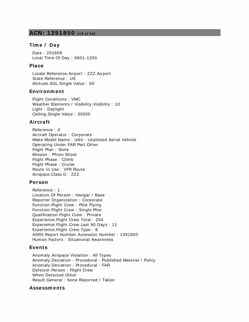
ACN: 1391850 (19 of 50)
Time / Day
Date : 201609
Local Time Of Day : 0601-1200
Place
Locale Reference.Airport : ZZZ.Airport
State Reference : US
Altitude.AGL.Single Value : 60
Environment
Flight Conditions : VMC
Weather Elements / Visibility.Visibility : 10
Light : Daylight
Ceiling.Single Value : 30000
Aircraft
Reference : X
Aircraft Operator : Corporate
Make Model Name : UAV - Unpiloted Aerial Vehicle
Operating Under FAR Part.Other
Flight Plan : None
Mission : Photo Shoot
Flight Phase : Climb
Flight Phase : Cruise
Route In Use : VFR Route
Airspace.Class D : ZZZ
Person
Reference : 1
Location Of Person : Hangar / Base
Reporter Organization : Corporate
Function.Flight Crew : Pilot Flying
Function.Flight Crew : Single Pilot
Qualification.Flight Crew : Private
Experience.Flight Crew.Total : 204
Experience.Flight Crew.Last 90 Days : 11
Experience.Flight Crew.Type : 8
ASRS Report Number.Accession Number : 1391850
Human Factors : Situational Awareness
Events
Anomaly.Airspace Violation : All Types
Anomaly.Deviation - Procedural : Published Material / Policy
Anomaly.Deviation - Procedural : FAR
Detector.Person : Flight Crew
When Detected.Other
Result.General : None Reported / Taken
Assessments
Contributing Factors / Situations : Environment - Non Weather Related
Contributing Factors / Situations : Human Factors
Contributing Factors / Situations : Procedure
Primary Problem : Human Factors
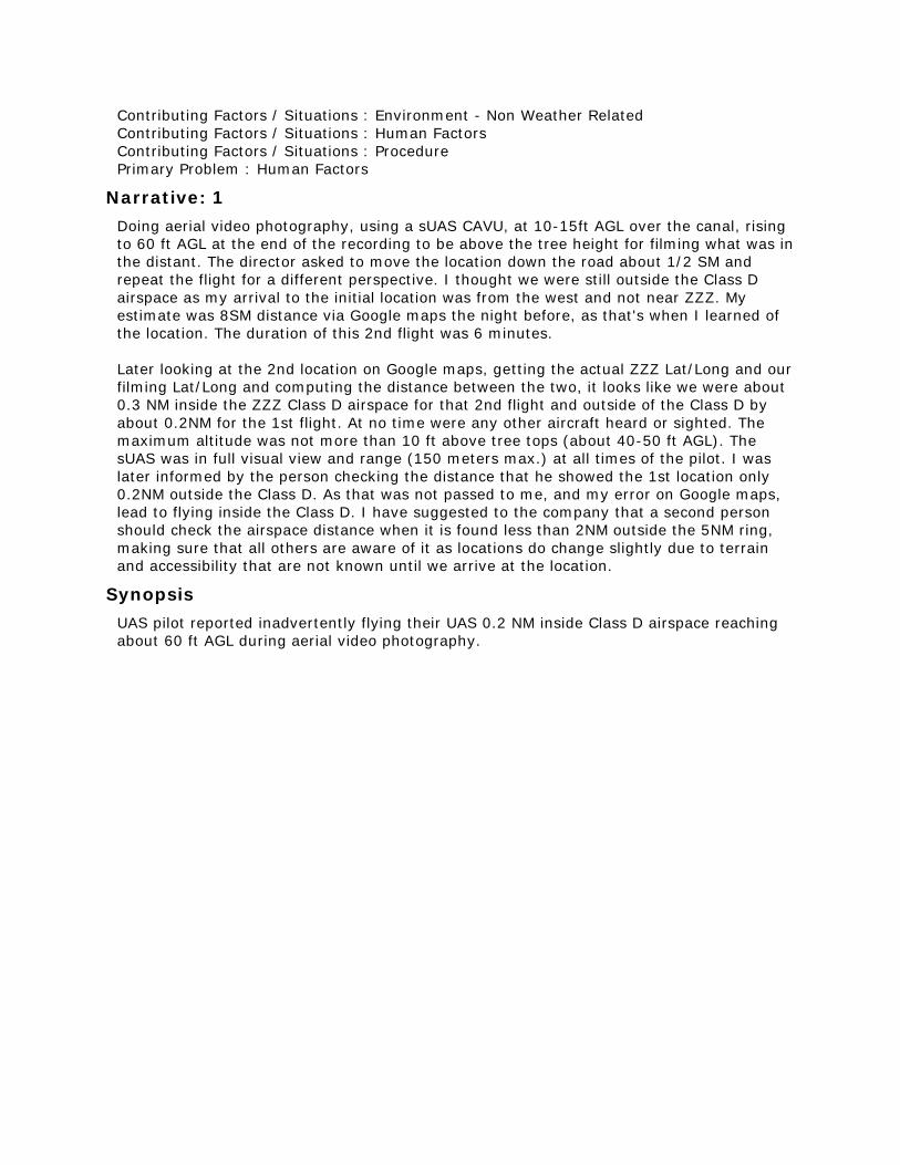
Narrative: 1
Doing aerial video photography, using a sUAS CAVU, at 10-15ft AGL over the canal, rising
to 60 ft AGL at the end of the recording to be above the tree height for filming what was in
the distant. The director asked to move the location down the road about 1/2 SM and
repeat the flight for a different perspective. I thought we were still outside the Class D
airspace as my arrival to the initial location was from the west and not near ZZZ. My
estimate was 8SM distance via Google maps the night before, as that's when I learned of
the location. The duration of this 2nd flight was 6 minutes.
Later looking at the 2nd location on Google maps, getting the actual ZZZ Lat/Long and our
filming Lat/Long and computing the distance between the two, it looks like we were about
0.3 NM inside the ZZZ Class D airspace for that 2nd flight and outside of the Class D by
about 0.2NM for the 1st flight. At no time were any other aircraft heard or sighted. The
maximum altitude was not more than 10 ft above tree tops (about 40-50 ft AGL). The
sUAS was in full visual view and range (150 meters max.) at all times of the pilot. I was
later informed by the person checking the distance that he showed the 1st location only
0.2NM outside the Class D. As that was not passed to me, and my error on Google maps,
lead to flying inside the Class D. I have suggested to the company that a second person
should check the airspace distance when it is found less than 2NM outside the 5NM ring,
making sure that all others are aware of it as locations do change slightly due to terrain
and accessibility that are not known until we arrive at the location.
Synopsis
UAS pilot reported inadvertently flying their UAS 0.2 NM inside Class D airspace reaching
about 60 ft AGL during aerial video photography.
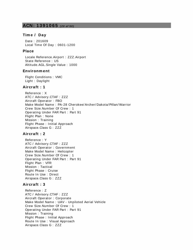
ACN: 1391065 (20 of 50)
Time / Day
Date : 201609
Local Time Of Day : 0601-1200
Place
Locale Reference.Airport : ZZZ.Airport
State Reference : US
Altitude.AGL.Single Value : 1000
Environment
Flight Conditions : VMC
Light : Daylight
Aircraft : 1
Reference : X
ATC / Advisory.CTAF : ZZZ
Aircraft Operator : FBO
Make Model Name : PA-28 Cherokee/Archer/Dakota/Pillan/Warrior
Crew Size.Number Of Crew : 1
Operating Under FAR Part : Part 91
Flight Plan : None
Mission : Training
Flight Phase : Initial Approach
Airspace.Class G : ZZZ
Aircraft : 2
Reference : Y
ATC / Advisory.CTAF : ZZZ
Aircraft Operator : Government
Make Model Name : Helicopter
Crew Size.Number Of Crew : 1
Operating Under FAR Part : Part 91
Flight Plan : VFR
Mission : Tactical
Flight Phase : Cruise
Route In Use : Direct
Airspace.Class G : ZZZ
Aircraft : 3
Reference : Z
ATC / Advisory.CTAF : ZZZ
Aircraft Operator : Corporate
Make Model Name : UAV - Unpiloted Aerial Vehicle
Crew Size.Number Of Crew : 1
Operating Under FAR Part : Part 91
Mission : Training
Flight Phase : Initial Approach
Route In Use : Visual Approach
Airspace.Class G : ZZZ
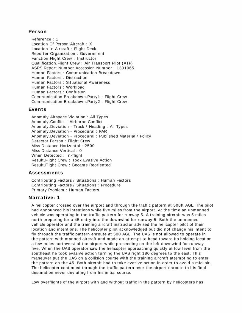
Person
Reference : 1
Location Of Person.Aircraft : X
Location In Aircraft : Flight Deck
Reporter Organization : Government
Function.Flight Crew : Instructor
Qualification.Flight Crew : Air Transport Pilot (ATP)
ASRS Report Number.Accession Number : 1391065
Human Factors : Communication Breakdown
Human Factors : Distraction
Human Factors : Situational Awareness
Human Factors : Workload
Human Factors : Confusion
Communication Breakdown.Party1 : Flight Crew
Communication Breakdown.Party2 : Flight Crew
Events
Anomaly.Airspace Violation : All Types
Anomaly.Conflict : Airborne Conflict
Anomaly.Deviation - Track / Heading : All Types
Anomaly.Deviation - Procedural : FAR
Anomaly.Deviation - Procedural : Published Material / Policy
Detector.Person : Flight Crew
Miss Distance.Horizontal : 2500
Miss Distance.Vertical : 0
When Detected : In-flight
Result.Flight Crew : Took Evasive Action
Result.Flight Crew : Became Reoriented
Assessments
Contributing Factors / Situations : Human Factors
Contributing Factors / Situations : Procedure
Primary Problem : Human Factors
Narrative: 1
A helicopter crossed over the airport and through the traffic pattern at 500ft AGL. The pilot
had announced his intentions while five miles from the airport. At the time an unmanned
vehicle was operating in the traffic pattern for runway 5. A training aircraft was 5 miles
north preparing for a 45 entry into the downwind for runway 5. Both the unmanned
vehicle operator and the training aircraft instructor advised the helicopter pilot of their
location and intentions. The helicopter pilot acknowledged but did not change his intent to
fly through the traffic pattern enroute at 500 AGL. The UAS is not allowed to operate in
the pattern with manned aircraft and made an attempt to head toward its holding location
a few miles northwest of the airport while proceeding on the left downwind for runway
five. When the UAS operator saw the helicopter approaching quickly at low level from the
southeast he took evasive action turning the UAS right 180 degrees to the east. This
maneuver put the UAS on a collision course with the training aircraft attempting to enter
the pattern on the 45. Both aircraft had to take evasive action in order to avoid a mid-air.
The helicopter continued through the traffic pattern over the airport enroute to his final
destination never deviating from his initial course.
Low overflights of the airport with and without traffic in the pattern by helicopters has
been an ongoing problem over the last year. They have been advised on multiple
occasions that the pattern is active with training aircraft yet they continue to cross over
the field at 500 AGL flying under and over aircraft in various phases of takeoff and landing.
Today it came to a head by causing a potential mid-air between a manned and unmanned
aircraft. Our fixed wing TPA is 1000 ft AGL, with no provision for helicopter traffic. This
airport is unique in that it is [a high traffic training airport]. In addition, unmanned vehicle
operates from the field for research, development, and training purposes. There is no
operational reason (both law enforcement and otherwise) for helicopters to cross over at
500 ft.
I feel it is important that action be taken to stop this helicopter practice due to the risk
that it imposes on both students and instructors operating aircraft in the pattern.
Synopsis
PA-28 instructor pilot reported a government helicopter flew through the CTAF VFR pattern
with a PA-28 and UAS in the pattern. The UAS had to change course to avoid the
helicopter, but that put it in conflict with the PA-28. Both training aircraft took evasive
action, but the helicopter pilot apparently did not.
ACN: 1390632 (21 of 50)
Time / Day
Date : 201609
Local Time Of Day : 1201-1800
Place
Locale Reference.Airport : ORD.Airport
State Reference : IL
Altitude.MSL.Single Value : 2400
Environment
Light : Daylight
Aircraft : 1
Reference : X
ATC / Advisory.Tower : ORD
ATC / Advisory.TRACON : C90
Aircraft Operator : Air Carrier
Make Model Name : A319
Crew Size.Number Of Crew : 2
Operating Under FAR Part : Part 121
Flight Plan : IFR
Mission : Passenger
Nav In Use : FMS Or FMC
Flight Phase : Initial Approach
Airspace.Class B : ORD
Aircraft : 2
Reference : Y
Make Model Name : UAV - Unpiloted Aerial Vehicle
Operating Under FAR Part : Part 91
Flight Phase : Cruise
Airspace.Class B : ORD
Person
Reference : 1
Location Of Person.Aircraft : X
Location In Aircraft : Flight Deck
Reporter Organization : Air Carrier
Function.Flight Crew : Captain
Function.Flight Crew : Pilot Not Flying
Qualification.Flight Crew : Air Transport Pilot (ATP)
Experience.Flight Crew.Total : 14000
Experience.Flight Crew.Last 90 Days : 240
Experience.Flight Crew.Type : 483
ASRS Report Number.Accession Number : 1390632
Human Factors : Situational Awareness
Human Factors : Workload
Human Factors : Distraction
Events
Anomaly.Airspace Violation : All Types
Anomaly.Conflict : Airborne Conflict
Anomaly.Deviation - Procedural : Published Material / Policy
Anomaly.Deviation - Procedural : FAR
Anomaly.Inflight Event / Encounter : Other / Unknown
Detector.Person : Flight Crew
Miss Distance.Vertical : 600
When Detected : In-flight
Result.Flight Crew : Requested ATC Assistance / Clarification
Assessments
Contributing Factors / Situations : Airport
Contributing Factors / Situations : Airspace Structure
Contributing Factors / Situations : Human Factors
Contributing Factors / Situations : Procedure
Primary Problem : Human Factors
Narrative: 1
A beach ball sized drone flew overhead traveling in the opposite direction of our approach
course. At approximately 1 mile prior to SEIKA, 28C FAF, and 2400 MSL, a silver reflective
drone was sighted above and to the right of our position. It was travel[ing] in a ENE
direction at about 3000. It was never a conflict to our flight path. Both Approach Control
and ORD tower were advised at the time of the sighting.
Synopsis
A319 Captain on approach to ORD Runway 28C at 2,400 feet reported a UAV at 3,000 feet
one mile prior to SEIKA.
ACN: 1390389 (22 of 50)
Time / Day
Date : 201607
Local Time Of Day : 0001-0600
Place
Locale Reference.Airport : 4G4.Airport
State Reference : OH
Altitude.MSL.Single Value : 2500
Environment
Flight Conditions : VMC
Light : Night
Aircraft : 1
Reference : X
ATC / Advisory.TRACON : PIT
Aircraft Operator : Air Taxi
Make Model Name : Helicopter
Crew Size.Number Of Crew : 2
Operating Under FAR Part : Part 135
Flight Plan : VFR
Mission : Passenger
Flight Phase : Cruise
Route In Use : VFR Route
Airspace.Class E : ZOB
Aircraft : 2
Reference : Y
Make Model Name : UAV - Unpiloted Aerial Vehicle
Operating Under FAR Part : Part 91
Flight Phase : Cruise
Airspace.Class E : ZOB
Aircraft : 3
Reference : Z
Make Model Name : UAV - Unpiloted Aerial Vehicle
Operating Under FAR Part : Part 91
Flight Phase : Cruise
Airspace.Class E : ZOB
Person
Reference : 1
Location Of Person.Aircraft : X
Location In Aircraft : Flight Deck
Reporter Organization : Air Taxi
Function.Flight Crew : Single Pilot
Qualification.Flight Crew : Rotorcraft
Qualification.Flight Crew : Commercial
ASRS Report Number.Accession Number : 1390389
Human Factors : Situational Awareness
Human Factors : Distraction
Human Factors : Workload
Events
Anomaly.Airspace Violation : All Types
Anomaly.Conflict : Airborne Conflict
Anomaly.Deviation - Procedural : FAR
Anomaly.Deviation - Procedural : Published Material / Policy
Detector.Person : Flight Crew
Miss Distance.Horizontal : 500
Miss Distance.Vertical : 0
When Detected : In-flight
Result.Flight Crew : Took Evasive Action
Result.Flight Crew : Requested ATC Assistance / Clarification
Assessments
Contributing Factors / Situations : Human Factors
Contributing Factors / Situations : Procedure
Primary Problem : Human Factors
Narrative: 1
Encountered 2 drones while inflight [near] 4G4 while maintaining 2500 feet MSL (heading
323 degrees). The pilot seated in the left front crew seat called out "two drones at 11 and
12 o'clock." Both drones appeared to be well within 500 feet of the aircraft, and at the
same altitude. An immediate climb of 1000 feet was initiated and calls were made to
approach control and operations. The drones were illuminated. The first one to be and
appeared to be red in color, and the second drone appeared to be white. The flight
continued without incident.
Synopsis
Helicopter pilot flying at 2,500 ft near 4G4 airport at night reported sighting two lighted
UAVs at his altitude so he climbed to 3,500 ft.
ACN: 1390317 (23 of 50)
Time / Day
Date : 201609
Local Time Of Day : 0601-1200
Place
Locale Reference.Airport : ORD.Airport
State Reference : IL
Altitude.MSL.Single Value : 4000
Environment
Flight Conditions : VMC
Light : Daylight
Aircraft : 1
Reference : X
ATC / Advisory.TRACON : C90
Aircraft Operator : Air Carrier
Make Model Name : B777 Undifferentiated or Other Model
Crew Size.Number Of Crew : 2
Operating Under FAR Part : Part 121
Flight Plan : IFR
Mission : Passenger
Nav In Use : FMS Or FMC
Nav In Use.Localizer/Glideslope/ILS : Runway 28C
Flight Phase : Initial Approach
Airspace.Class B : ORD
Aircraft : 2
Reference : Y
Make Model Name : UAV - Unpiloted Aerial Vehicle
Operating Under FAR Part : Part 91
Flight Phase : Cruise
Airspace.Class B : ORD
Person
Reference : 1
Location Of Person.Aircraft : X
Location In Aircraft : Flight Deck
Reporter Organization : Air Carrier
Function.Flight Crew : Captain
Function.Flight Crew : Pilot Not Flying
Qualification.Flight Crew : Air Transport Pilot (ATP)
Experience.Flight Crew.Type : 971
ASRS Report Number.Accession Number : 1390317
Events
Detector.Person : Flight Crew
When Detected : In-flight
Result.General : None Reported / Taken
Assessments
Contributing Factors / Situations : Human Factors
Primary Problem : Human Factors
Narrative: 1
On approach to 28C at ORD. Cleared for the approach at 4000 ft over HAZIL. First Officer
was pilot flying. Just as the descent was started on the glideslope over the shoreline of
Lake Michigan, I saw a drone below and to the left side of the nose of the airplane pass
underneath. My best guess on the altitude is 2000-3000 ft. It was close enough to my
aircraft that I could see 2 white propellers on the top. The body appeared to be orange in
color. It was only in sight for a couple of seconds before passing underneath the nose. I
reported the sighting to ATC.
Synopsis
B777 Captain reported sighting a UAV about 1500 feet below his aircraft while on
approach to ORD Runway 28C.
ACN: 1390151 (24 of 50)
Time / Day
Date : 201609
Local Time Of Day : 0601-1200
Place
Locale Reference.Airport : HMT.Airport
State Reference : CA
Relative Position.Angle.Radial : 190
Relative Position.Distance.Nautical Miles : 1.7
Altitude.MSL.Single Value : 2200
Environment
Flight Conditions : VMC
Weather Elements / Visibility.Visibility : 10
Light : Daylight
Ceiling : CLR
Aircraft : 1
Reference : X
ATC / Advisory.CTAF : HMT
Aircraft Operator : FBO
Make Model Name : PA-28 Cherokee/Archer/Dakota/Pillan/Warrior
Crew Size.Number Of Crew : 2
Operating Under FAR Part : Part 91
Flight Plan : None
Mission : Training
Flight Phase : Initial Climb
Route In Use : None
Airspace.Class E : RIV
Aircraft : 2
Reference : Y
Aircraft Operator : Personal
Make Model Name : UAV - Unpiloted Aerial Vehicle
Operating Under FAR Part : Part 91
Mission : Personal
Airspace.Class G : HMT
Person
Reference : 1
Location Of Person.Aircraft : X
Location In Aircraft : Flight Deck
Reporter Organization : FBO
Function.Flight Crew : Instructor
Function.Flight Crew : Pilot Not Flying
Qualification.Flight Crew : Instrument
Qualification.Flight Crew : Commercial
Qualification.Flight Crew : Flight Instructor
Qualification.Flight Crew : Multiengine
Experience.Flight Crew.Total : 650
Experience.Flight Crew.Last 90 Days : 170
Experience.Flight Crew.Type : 640
ASRS Report Number.Accession Number : 1390151
Events
Anomaly.Conflict : Airborne Conflict
Detector.Person : Flight Crew
Miss Distance.Horizontal : 2000
Miss Distance.Vertical : 100
When Detected : In-flight
Result.General : None Reported / Taken
Assessments
Contributing Factors / Situations : Airport
Contributing Factors / Situations : Human Factors
Primary Problem : Airport
Narrative: 1
While departing from HMT Runway 23, my student noticed an unmanned aircraft, that
appeared to be a recreational use RC aircraft operating in the area about 1.7 miles
southwest of HMT. There appeared to be a miniaturized runway constructed of concrete on
the ground with multiple RC aircraft on the ground. The UAS appeared to be operating
about 100 feet below us, and about 2000 feet laterally to our left. This would put the
aircraft at about 500-600 feet AGL. The aircraft did not pose an immediate threat to us,
however the aircraft and the field it appeared to be operating from are located in the flight
path normally used by pilots performing a 45 degree entry to the left downwind of runway
23. There were no notices on the airport ASOS or over any other frequencies.
Synopsis
PA28 instructor pilot reported that a miniature airport for model aircraft is located 1.7 NM
SW of the HMT airport and one of the aircraft came in conflict with them nearby the RC
strip.
ACN: 1390011 (25 of 50)
Time / Day
Date : 201609
Local Time Of Day : 0601-1200
Place
Locale Reference.Airport : SFB.Airport
State Reference : FL
Altitude.MSL.Single Value : 1600
Environment
Flight Conditions : VMC
Light : Daylight
Aircraft : 1
Reference : X
ATC / Advisory.TRACON : F11
Aircraft Operator : FBO
Make Model Name : Skyhawk 172/Cutlass 172
Crew Size.Number Of Crew : 2
Operating Under FAR Part : Part 91
Mission : Training
Flight Phase : Initial Approach
Route In Use : VFR Route
Airspace.Class C : SFB
Aircraft : 2
Reference : Y
Aircraft Operator : Personal
Make Model Name : UAV - Unpiloted Aerial Vehicle
Operating Under FAR Part : Part 91
Mission : Personal
Flight Phase : Cruise
Airspace.Class C : SFB
Person
Reference : 1
Location Of Person.Aircraft : X
Location In Aircraft : Flight Deck
Reporter Organization : FBO
Function.Flight Crew : Pilot Not Flying
Function.Flight Crew : Instructor
Qualification.Flight Crew : Flight Instructor
Qualification.Flight Crew : Commercial
ASRS Report Number.Accession Number : 1390011
Events
Anomaly.Conflict : Airborne Conflict
Anomaly.Deviation - Procedural : FAR
Detector.Person : Flight Crew
When Detected : In-flight
Result.Flight Crew : Took Evasive Action
Assessments
Contributing Factors / Situations : Human Factors
Primary Problem : Human Factors
Narrative: 1
On the Monroe Approach into SFB, Student saw something that look[ed] to be a black dot
floating in the air from the right of the wing of the aircraft. Instructor Pilot (IP) scanned
the area to verify information from the student, IP identified the black dot to be a
Drone/Quad-helicopter floating in mid-air around 1500-1600 ft on the Monroe arrival path.
IP took action and avoided the drone (stationary) and reported to Orlando App for the
drone. Orlando App asked for a brief description and information was given to the best of
the ability at the time. No further incident occurred afterwards. Switched over to Tower
and continued for closed traffic. Incident was written up for safety after the flight.
Synopsis
C172 instructor pilot reported sighting a drone at 1600 feet during arrival to SFB. Evasive
action was taken.
ACN: 1389549 (26 of 50)
Time / Day
Date : 201609
Local Time Of Day : 0601-1200
Place
Locale Reference.Airport : ZZZ.Airport
State Reference : US
Altitude.AGL.Single Value : 10
Environment
Flight Conditions : VMC
Weather Elements / Visibility.Visibility : 10
Light : Daylight
Ceiling.Single Value : 9000
Aircraft
Reference : X
Aircraft Operator : Corporate
Make Model Name : UAV - Unpiloted Aerial Vehicle
Crew Size.Number Of Crew : 1
Operating Under FAR Part.Other
Flight Plan : None
Mission : Photo Shoot
Flight Phase : Cruise
Route In Use : None
Airspace.Class G : ZZZ
Person
Reference : 1
Location Of Person : Hangar / Base
Reporter Organization : Corporate
Function.Flight Crew : Pilot Flying
Qualification.Flight Crew : Instrument
Qualification.Flight Crew : Commercial
Qualification.Flight Crew : Multiengine
Experience.Flight Crew.Total : 500
Experience.Flight Crew.Last 90 Days : 90
Experience.Flight Crew.Type : 200
ASRS Report Number.Accession Number : 1389549
Human Factors : Situational Awareness
Events
Anomaly.Deviation - Procedural : FAR
Detector.Person : Flight Crew
Miss Distance.Horizontal : 0
Miss Distance.Vertical : 10
When Detected : Routine Inspection
Result.General : None Reported / Taken
Assessments
Contributing Factors / Situations : Environment - Non Weather Related
Contributing Factors / Situations : Human Factors
Primary Problem : Human Factors
Narrative: 1
While conducting a cinematography flight under part 107, I inadvertently flew over people.
I was focused on conducting the flight line of sight, avoiding obstacles at the altitude of
the drone as best I could see from a cleared designated landing area. Upon reviewing the
recorded video of the TV broadcast after returning home, I realized that a number of
people who were not part of the operation were directly underneath the flight path of the
drone. In the future I will utilize visual observers along the boundaries of the designated
flying area who can let me know if I get close to the edge of this boundary.
Synopsis
UAV pilot reported discovering after the fact that his aircraft overflew people at low
altitude during a cinematography flight under part 107.
ACN: 1389014 (27 of 50)
Time / Day
Date : 201609
Local Time Of Day : 0601-1200
Place
Locale Reference.Airport : IAG.Airport
State Reference : NY
Altitude.AGL.Single Value : 395
Environment
Flight Conditions : VMC
Weather Elements / Visibility.Visibility : 10
Light : Daylight
Ceiling.Single Value : 25000
Aircraft
Reference : X
Aircraft Operator : Personal
Make Model Name : UAV - Unpiloted Aerial Vehicle
Crew Size.Number Of Crew : 1
Operating Under FAR Part.Other
Flight Plan : None
Mission : Personal
Flight Phase : Cruise
Route In Use : None
Person
Reference : 1
Location Of Person : Hangar / Base
Reporter Organization : Personal
Function.Flight Crew : Single Pilot
Qualification.Flight Crew : Private
Experience.Flight Crew.Total : 750
Experience.Flight Crew.Last 90 Days : 25
Experience.Flight Crew.Type : 30
ASRS Report Number.Accession Number : 1389014
Human Factors : Situational Awareness
Events
Anomaly.Airspace Violation : All Types
Anomaly.Deviation - Procedural : Published Material / Policy
Anomaly.Deviation - Procedural : FAR
Detector.Person : Flight Crew
When Detected : In-flight
Result.General : None Reported / Taken
Assessments
Contributing Factors / Situations : Airspace Structure
Contributing Factors / Situations : Human Factors
Primary Problem : Human Factors
Narrative: 1
I hold two FAA ratings: Part 61 Private Pilot ASEL and Part 107 Remote Pilot, small
Unmanned Aircraft System. I carefully researched flying a small unmanned aircraft system
over Niagara Falls weeks before this flight. Pilot safely and legally launched, and
subsequently landed, a drone (UAS) from the New York State side of the Falls with most of
the flight taking place over the American Falls, also located on the New York State side.
While in the course of this carefully planned, and safe, controlled flight over Niagara Falls,
pilot failed to recognize the exact part of the airspace over the Horseshoe Falls that is
actually in Canadian Airspace. This was realized after the flight was concluded and verified
with mapping on the DJI Go app, which records the sequence of flight.
Also, it is believed the altitudes indicated during flight were not accurate even after the
UAS was properly calibrated over a grass surface. Some of the recorded altitudes indicate
higher than 400 AGL and believe this may be a composite measurement of the launch
point altitude of 614 feet MSL and the drop off over the falls descending to as low as 167
feet below that, indicating an MSL altitude of 447 feet. In the future I shall also contact
Transport Canada before any flights over the Horseshoe Falls, even if the flight begins and
ends in United States Airspace.
Synopsis
A UAS pilot realized after a flight over the Horseshoe Falls portion of Niagara Falls that he
may have inadvertently flown into Canadian Airspace. Also, the UAS postflight altitude
indicated greater than 400 ft because the 167 ft waterfall drop off made the aircraft
appear higher than the preflight calibrated altitude.
ACN: 1388373 (28 of 50)
Time / Day
Date : 201609
Local Time Of Day : 0601-1200
Place
Locale Reference.Airport : ZZZ.Airport
State Reference : US
Altitude.AGL.Single Value : 200
Environment
Flight Conditions : VMC
Light : Dawn
Aircraft
Reference : X
Aircraft Operator : Personal
Make Model Name : UAV - Unpiloted Aerial Vehicle
Operating Under FAR Part : Part 91
Flight Plan : None
Mission : Personal
Flight Phase : Cruise
Airspace.Class G : ZZZ
Person
Reference : 1
Location Of Person : Gate / Ramp / Line
Reporter Organization : Personal
Function.Flight Crew : Single Pilot
Experience.Flight Crew.Total : 0
ASRS Report Number.Accession Number : 1388373
Human Factors : Situational Awareness
Events
Anomaly.Airspace Violation : All Types
Anomaly.Deviation - Procedural : FAR
Detector.Person : Ground Personnel
When Detected.Other
Result.Flight Crew : Became Reoriented
Assessments
Contributing Factors / Situations : Human Factors
Primary Problem : Human Factors
Narrative: 1
It was brought to my attention by the Airport Manager (email notification received) that
my recent recreational drone flight unintentionally and unknowingly occurred within 5
miles of the airport. I was vacationing with my family and I was unaware of my proximity
to the airport which sits on a mesa roughly 600 ft above my flight location. During my
flight I ascended to an altitude of 200-300 ft above ground level for a total flight time of
roughly 2-3 minutes. After reviewing my location on several maps, I estimate my distance
from the airport to be approximately 2 miles. I then drove to another location several
miles away and flew the same drone.
Synopsis
A UAS pilot was notified by an Airport Manager via email that his UAS had been flown
within 5 NM of the airport.
ACN: 1387544 (29 of 50)
Time / Day
Date : 201609
Local Time Of Day : 1201-1800
Place
Locale Reference.Airport : MDW.Airport
State Reference : IL
Altitude.AGL.Single Value : 400
Environment
Flight Conditions : VMC
Weather Elements / Visibility.Visibility : 10
Light : Daylight
Ceiling.Single Value : 3000
Aircraft : 1
Reference : X
ATC / Advisory.Tower : MDW
Aircraft Operator : Corporate
Make Model Name : Citation II S2/Bravo (C550)
Crew Size.Number Of Crew : 2
Operating Under FAR Part : Part 91
Flight Plan : IFR
Mission : Passenger
Flight Phase : Initial Climb
Route In Use.SID : MIDWAY2
Airspace.Class C : MDW
Aircraft : 2
Reference : Y
Make Model Name : UAV - Unpiloted Aerial Vehicle
Operating Under FAR Part : Part 91
Flight Phase : Cruise
Airspace.Class C : MDW
Person
Reference : 1
Location Of Person.Aircraft : X
Location In Aircraft : Flight Deck
Reporter Organization : Corporate
Function.Flight Crew : Captain
Function.Flight Crew : Pilot Flying
Qualification.Flight Crew : Multiengine
Qualification.Flight Crew : Air Transport Pilot (ATP)
Experience.Flight Crew.Total : 8600
Experience.Flight Crew.Last 90 Days : 65
Experience.Flight Crew.Type : 2200
ASRS Report Number.Accession Number : 1387544
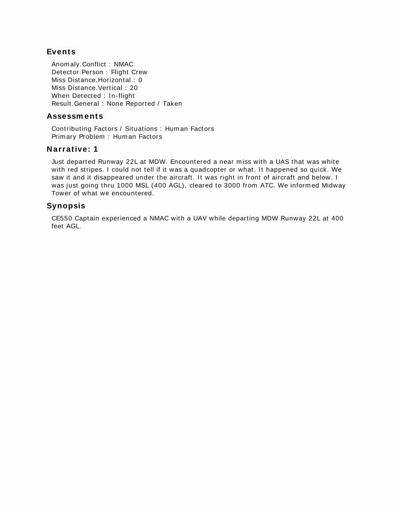
Events
Anomaly.Conflict : NMAC
Detector.Person : Flight Crew
Miss Distance.Horizontal : 0
Miss Distance.Vertical : 20
When Detected : In-flight
Result.General : None Reported / Taken
Assessments
Contributing Factors / Situations : Human Factors
Primary Problem : Human Factors
Narrative: 1
Just departed Runway 22L at MDW. Encountered a near miss with a UAS that was white
with red stripes. I could not tell if it was a quadcopter or what. It happened so quick. We
saw it and it disappeared under the aircraft. It was right in front of aircraft and below. I
was just going thru 1000 MSL (400 AGL), cleared to 3000 from ATC. We informed Midway
Tower of what we encountered.
Synopsis
CE550 Captain experienced a NMAC with a UAV while departing MDW Runway 22L at 400
feet AGL.
ACN: 1387105 (30 of 50)
Time / Day
Date : 201609
Local Time Of Day : 1801-2400
Place
Locale Reference.Airport : Y31.Airport
State Reference : MI
Altitude.MSL.Single Value : 7400
Environment
Flight Conditions : VMC
Light : Daylight
Aircraft : 1
Reference : X
ATC / Advisory.TRACON : MBS
Aircraft Operator : Personal
Make Model Name : Cessna 150
Crew Size.Number Of Crew : 1
Operating Under FAR Part : Part 91
Flight Plan : VFR
Mission : Personal
Flight Phase : Cruise
Route In Use : Direct
Airspace.Class E : MBS
Aircraft : 2
Reference : Y
Make Model Name : UAV - Unpiloted Aerial Vehicle
Flight Plan : None
Flight Phase : Cruise
Airspace.Class E : MBS
Person
Reference : 1
Location Of Person.Aircraft : X
Location In Aircraft : Flight Deck
Reporter Organization : Personal
Function.Flight Crew : Pilot Flying
Function.Flight Crew : Single Pilot
Qualification.Flight Crew : Commercial
Qualification.Flight Crew : Flight Instructor
Qualification.Flight Crew : Instrument
Experience.Flight Crew.Total : 850
Experience.Flight Crew.Last 90 Days : 30
Experience.Flight Crew.Type : 220
ASRS Report Number.Accession Number : 1387105
Human Factors : Distraction
Human Factors : Workload
Events
Anomaly.Airspace Violation : All Types
Anomaly.Conflict : NMAC
Anomaly.Deviation - Procedural : Published Material / Policy
Anomaly.Deviation - Procedural : FAR
Anomaly.Inflight Event / Encounter : Object
Detector.Person : Flight Crew
Miss Distance.Horizontal : 300
Miss Distance.Vertical : 300
When Detected : In-flight
Result.Flight Crew : Requested ATC Assistance / Clarification
Assessments
Contributing Factors / Situations : Human Factors
Contributing Factors / Situations : Procedure
Primary Problem : Human Factors
Narrative: 1
I was level in cruise flight, south/southeast bound at 7,400 (slightly off my desired altitude
of 7,500) receiving basic radar service from ATCT/TRACON. While looking outside my left
window, I noticed a drone/UAV just below my altitude by approximately 300 feet and less
than 500 feet away horizontally. It was moving due northbound. The drone appeared to be
shaped like a long dumbbell in a vertical orientation, with a motor of some sort on the top
propelling it forward, dragging a lower section (perhaps a camera) that was connected to a
cable of some sort. The drone was silver in color (possibly white and just reflecting brightly
from the sun beginning to set in the west), approximately 3 feet long (top to bottom), and
very narrow in width. I have experienced seeing weather balloons before, but this did not
appear to be one, and this was to my knowledge not a weather balloon launch area. The
top portion of this drone was not inflated and did not appear inflatable. I notified ATC as
soon as the drone was spotted.
I was quite surprised at the potential this encounter had for becoming a midair collision.
Given my airplane's small size, this could have easily caused an emergency had I been
just a hare more to the east where this drone was flying, and just a touch more off of my
preplanned altitude.
Synopsis
A C150 pilot at 7,400 ft reported a near miss with what appeared to be a camera carrying
drone.
ACN: 1386746 (31 of 50)
Time / Day
Date : 201609
Local Time Of Day : 1801-2400
Place
Locale Reference.Airport : 61VA.Airport
State Reference : VA
Altitude.AGL.Single Value : 350
Environment
Flight Conditions : VMC
Light : Daylight
Aircraft
Reference : X
Aircraft Operator : Personal
Make Model Name : UAV - Unpiloted Aerial Vehicle
Operating Under FAR Part : Part 91
Mission : Training
Airspace.Class G : 61VA
Person
Reference : 1
Location Of Person : Hangar / Base
Reporter Organization : Personal
Function.Flight Crew : Pilot Flying
Qualification.Flight Crew : Flight Instructor
Qualification.Flight Crew : Commercial
Experience.Flight Crew.Total : 3500
Experience.Flight Crew.Last 90 Days : 40
ASRS Report Number.Accession Number : 1386746
Human Factors : Other / Unknown
Human Factors : Situational Awareness
Events
Anomaly.Airspace Violation : All Types
Anomaly.Deviation - Procedural : Published Material / Policy
Detector.Person : Flight Crew
When Detected : Routine Inspection
Result.Flight Crew : Became Reoriented
Assessments
Contributing Factors / Situations : Chart Or Publication
Contributing Factors / Situations : Human Factors
Primary Problem : Human Factors
Narrative: 1
I misread the distance from the location of my hobbyist UAS training flight and was about
4 miles from High View Airport, a private, non-towered airport in northern Virginia,
approximately 10 nm south of MRB. I had tried to contact the owner of the airport
previously in order to discuss contacting him if need be and never received a response
from him. There are actually two other private airports in the immediate vicinity of High
View, but they are not charted on the Washington Sectional. They are actually busier than
High View which sees very little activity. None of the three have more than 1 or two flights
per week that I can tell. I went back to the area I flew and used the B4UFly app and
discovered my measurement error.
There does not seem to be a good way to find contact information for private airports.
None appear in the FAA's Chart Supplement book (formerly Airport Facility Directory) and
I cannot find contact info on web based programs like ForeFlight. If the FAA is going to
require notification of private airports (as this showed up on B4UFly), we need a source of
contact information. I just happened to know the owner of High View and as stated before
had tried unsuccessfully to contact him.
Synopsis
UAV pilot discovered after the fact that he flew within 4 NM of a private airport. He
believes that if the FAA is going to require notification to private airports a source of
contact information needs to be available. There does not seem to be a good way to find
contact information for private airports.
ACN: 1386058 (32 of 50)
Time / Day
Date : 201609
Local Time Of Day : 0601-1200
Place
Locale Reference.ATC Facility : ZZZ.ARTCC
State Reference : US
Altitude.MSL.Single Value : 20000
Environment
Flight Conditions : VMC
Light : Daylight
Aircraft
Reference : X
ATC / Advisory.Center : ZZZ
Aircraft Operator : Government
Make Model Name : UAV - Unpiloted Aerial Vehicle
Crew Size.Number Of Crew : 1
Operating Under FAR Part : Part 91
Flight Plan : IFR
Mission : Utility
Flight Phase : Cruise
Airspace.Class A : ZZZ
Component
Aircraft Component : Navigational Equipment and Processing
Aircraft Reference : X
Problem : Malfunctioning
Person
Reference : 1
Location Of Person : Company
Reporter Organization : Government
Function.Flight Crew : Pilot Flying
Qualification.Flight Crew : Instrument
Qualification.Flight Crew : Air Transport Pilot (ATP)
Qualification.Flight Crew : Flight Instructor
Qualification.Flight Crew : Multiengine
Experience.Flight Crew.Total : 8200
Experience.Flight Crew.Last 90 Days : 50
Experience.Flight Crew.Type : 100
ASRS Report Number.Accession Number : 1386058
Human Factors : Human-Machine Interface
Human Factors : Situational Awareness
Human Factors : Time Pressure
Human Factors : Confusion
Events
Anomaly.Airspace Violation : All Types
Anomaly.Deviation - Track / Heading : All Types
Anomaly.Deviation - Procedural : Clearance
Anomaly.Inflight Event / Encounter : Loss Of Aircraft Control
Detector.Person : Flight Crew
When Detected : In-flight
Result.Flight Crew : Became Reoriented
Result.Flight Crew : Regained Aircraft Control
Result.Flight Crew : Returned To Clearance
Assessments
Contributing Factors / Situations : Aircraft
Primary Problem : Aircraft
Narrative: 1
The tracker display showed the aircraft turning left north toward Canada less than a mile
from the border. Flying at about 105 knots indicated airspeed and flight level 200, it had
just passed the entry waypoint for the operational mission it had been flying for several
circuits. I expected it to turn right and away from Canada toward the next waypoint. To
correct the unintended left turn, I turned off preprogrammed mode, returning the aircraft
to heading, altitude, and airspeed hold modes. I then set the commanded heading
southward. The aircraft responded by maintaining altitude and airspeed and continuing the
left turn to the commanded heading. During the course of these events the aircraft
completed a 180 degree turn through Canada and crossed back into the United States.
As the preprogrammed track had been one mile from the border, there was little time to
catch the unanticipated change in the flight path. The last waypoint in the operational
mission was about one to two miles from the entry waypoint. The entry waypoint was on
the same line as the previous leg of the preprogrammed mission. Winds were quartering
from the right rear around 35 knots. The aircraft datalink was via Ku-band satellite with
Line of Sight backup. I did not notice any relevant warnings in the heads down display and
did not notice any abnormalities during the previous three hours of flight. I built a new
operational mission about five nautical miles south of the border. The aircraft responded
as I intended to this guidance, and I noted no further abnormalities during the remainder
of the flight.
I believe the aircraft had not been able to successfully transition from the last waypoint to
the entry waypoint and had initiated the left turn to restart the preprogrammed route. I
built the next mission with more space between the last and entry waypoints to allow
more space for the aircraft to transition from waypoint to waypoint.
Synopsis
A MQ-9 UAV pilot reported his aircraft's preprogrammed track near the Canadian border
malfunctioned and the aircraft entered Canadian airspace. The aircraft's manual mode was
activated to depart Canada and a new preprogrammed track built further from the border.
ACN: 1383510 (33 of 50)
Time / Day
Date : 201608
Local Time Of Day : 1201-1800
Place
Locale Reference.Airport : ARR.Airport
State Reference : IL
Relative Position.Angle.Radial : 120
Relative Position.Distance.Nautical Miles : 11.5
Altitude.MSL.Single Value : 1700
Environment
Flight Conditions : VMC
Weather Elements / Visibility.Visibility : 10
Light : Daylight
Ceiling : CLR
Aircraft : 1
Reference : X
Aircraft Operator : FBO
Make Model Name : Small Aircraft, High Wing, 1 Eng, Fixed Gear
Crew Size.Number Of Crew : 1
Operating Under FAR Part : Part 91
Flight Plan : None
Mission : Traffic Watch
Flight Phase : Cruise
Route In Use : Direct
Airspace.Class E : C90
Aircraft : 2
Reference : Y
Make Model Name : UAV - Unpiloted Aerial Vehicle
Flight Phase : Cruise
Airspace.Class E : C90
Person
Reference : 1
Location Of Person.Aircraft : X
Location In Aircraft : Flight Deck
Reporter Organization : Contracted Service
Function.Flight Crew : Pilot Flying
Function.Flight Crew : Single Pilot
Qualification.Flight Crew : Instrument
Qualification.Flight Crew : Commercial
Experience.Flight Crew.Total : 460
Experience.Flight Crew.Last 90 Days : 70
Experience.Flight Crew.Type : 160
ASRS Report Number.Accession Number : 1383510
Human Factors : Confusion
Human Factors : Distraction
Events
Anomaly.Conflict : NMAC
Detector.Person : Flight Crew
Miss Distance.Horizontal : 100
Miss Distance.Vertical : 0
Were Passengers Involved In Event : Y
When Detected : In-flight
Result.Flight Crew : Took Evasive Action
Assessments
Contributing Factors / Situations : Airspace Structure
Contributing Factors / Situations : Environment - Non Weather Related
Contributing Factors / Situations : Human Factors
Primary Problem : Airspace Structure
Narrative: 1
While enroute in cruise flight on my normal route for traffic watch, I encountered another
aircraft over the location noted. I noticed the aircraft as it appeared approximately 100ft
ahead, directly 12 o'clock to my aircraft's nose, flying head on at my aircraft. Immediately
I banked my aircraft to the right, and the other aircraft banked to its right. The aircraft
was at the same altitude, 1,700 ft. The aircraft was not a manned aircraft, possibly a
heavy duty remote control airplane or a UAV. It was red and white, and looked similar to a
glider but much smaller. It did not appear on my ADS-B receiver. To my knowledge, it is
not legal to fly an unmanned aircraft at the altitude I was at, which endangered the safety
of my flight and passenger, as well as scaring my passenger. The aircraft had no anti-
collision light operating and was difficult to see until it was very close. I am unsure if there
are any means of finding the operator of this aircraft, but I felt it necessary to report as
the aircraft is operating possibly illegally and may potentially cause more incidents in the
future with other aircraft.
Synopsis
A small aircraft pilot reported a close encounter with a UAV. He took immediate evasive
action and avoided a collision with the UAV.
ACN: 1382762 (34 of 50)
Time / Day
Date : 201608
Local Time Of Day : 1201-1800
Place
Locale Reference.Airport : ZZZ.Airport
State Reference : US
Altitude.AGL.Single Value : 250
Environment
Flight Conditions : VMC
Weather Elements / Visibility.Visibility : 30
Light : Daylight
Ceiling.Single Value : 5000
Aircraft
Reference : X
Aircraft Operator : FBO
Make Model Name : UAV - Unpiloted Aerial Vehicle
Crew Size.Number Of Crew : 1
Operating Under FAR Part : Part 91
Flight Plan : None
Mission : Training
Flight Phase : Cruise
Route In Use : None
Airspace.Class G : ZZZ
Person
Reference : 1
Location Of Person.Aircraft : X
Location In Aircraft : Flight Deck
Reporter Organization : FBO
Function.Flight Crew : Pilot Flying
Function.Flight Crew : Single Pilot
Qualification.Flight Crew : Air Transport Pilot (ATP)
Qualification.Flight Crew : Flight Instructor
Qualification.Flight Crew : Multiengine
Qualification.Flight Crew : Instrument
Qualification.Flight Crew : Flight Engineer
Experience.Flight Crew.Total : 7000
Experience.Flight Crew.Last 90 Days : 30
Experience.Flight Crew.Type : 5
ASRS Report Number.Accession Number : 1382762
Human Factors : Distraction
Events
Anomaly.No Specific Anomaly Occurred : All Types
Detector.Person : Flight Crew
When Detected : In-flight
Result.General : Police / Security Involved
Result.Flight Crew : Became Reoriented
Result.Flight Crew : Took Evasive Action
Assessments
Contributing Factors / Situations : Environment - Non Weather Related
Contributing Factors / Situations : Human Factors
Primary Problem : Human Factors
Narrative: 1
After operating a small UAS, 5 lb foam fixed wing "SwiftTrainer", I was approached by a
very confrontational woman who claimed I was not allowed to take pictures of her and fly
over her with a drone. We were flying under a COA (Certificate of Approval) for a public
university, as employees of that university, flying an aircraft owned and registered by that
university and on land owned by the university. She was never visible to my Visual
Observer (VO) or myself during the flight. The mission was a training and familiarization
flight for the UAS. There was never any intent to do anything other than fly a practice
photogrammetry mission at 75 meters elevation. The land we were flying over was
undeveloped university owned open space with some trees and bushes that has a dirt road
around it and signs posted that the trails and land are closed for reclamation. People are
allowed to walk on the road but not off it. We were parked on the road but were flying
over the open space. We, as university employees, are allowed to be anywhere on the
land since we are employees doing work and research. I explained to her that we were
within our right to fly there but she was combative and did not want to hear the rules at
play. I eventually told her to call the police, which she did. An officer from our police
department came and talked with us, he was helpful and nice. As employees who were
clearly authorized to be there and doing research within all applicable laws he simply left
after a few moments and we continued with our flying operations.
My concern is how a citizen who has no understanding of the rules at play in a UAS
operation such as ours can approach us and distract us from our operation. If we
happened to be flying at the time she accosted us it would have certainly been a violation
of the "sterile cockpit" principal and could have caused an accident or mishap. If the UAS
would have been 50lbs instead of 5lbs this could have posed a risk to life and limb. I am
considering implementing a policy in our UAS operations where we have a "guard" with us
when we fly larger UAS. This guard's sole responsibility would be to ensure that nobody
approaches the PIC or VO when flight operations are being conducted. 99.9 percent of
individuals we encounter when we are flying UAS are pleasant, never distract anybody
who is flying, and are just interested in the watching or learning about the technology. It's
fairly easy to maintain a "sterile cockpit" from outsiders in an airliner with a hardened
door. It's another thing entirely to maintain a "sterile cockpit" when anybody can simply
walk up behind you and distract you from flight operations.
Synopsis
A UAS pilot employed by a university reported being confronted by a passerby on school
property which caused a distraction. The reporter was concerned about the ability to
maintain the "sterile cockpit" policy when operating in open and public areas.
ACN: 1381776 (35 of 50)
Time / Day
Date : 201608
Local Time Of Day : 1201-1800
Place
Locale Reference.Airport : ZZZ.Airport
State Reference : US
Altitude.AGL.Single Value : 650
Environment
Flight Conditions : VMC
Weather Elements / Visibility.Visibility : 10
Light : Daylight
Ceiling.Single Value : 12000
Aircraft : 1
Reference : X
ATC / Advisory.Tower : ZZZ
Aircraft Operator : FBO
Make Model Name : Helicopter
Crew Size.Number Of Crew : 2
Operating Under FAR Part : Part 91
Flight Plan : VFR
Mission : Utility
Flight Phase : Cruise
Airspace.Class G : ZZZ
Aircraft : 2
Reference : Y
Aircraft Operator : Personal
Make Model Name : UAV - Unpiloted Aerial Vehicle
Mission : Personal
Flight Phase : Cruise
Airspace.Class G : ZZZ
Person
Reference : 1
Location Of Person.Aircraft : X
Location In Aircraft : Flight Deck
Reporter Organization : Contracted Service
Function.Flight Crew : Captain
Function.Flight Crew : Pilot Flying
Qualification.Flight Crew : Flight Instructor
Qualification.Flight Crew : Commercial
ASRS Report Number.Accession Number : 1381776
Human Factors : Distraction
Human Factors : Situational Awareness
Human Factors : Workload
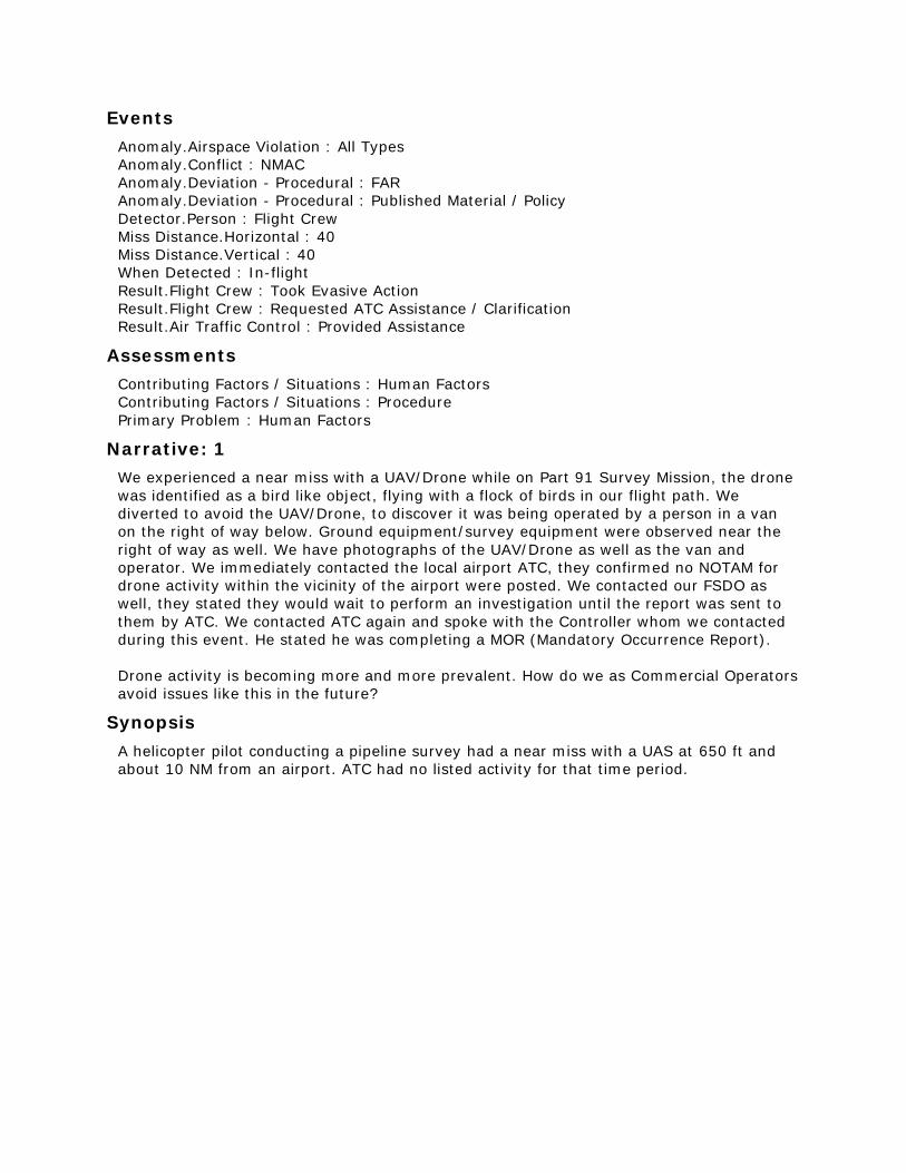
Events
Anomaly.Airspace Violation : All Types
Anomaly.Conflict : NMAC
Anomaly.Deviation - Procedural : FAR
Anomaly.Deviation - Procedural : Published Material / Policy
Detector.Person : Flight Crew
Miss Distance.Horizontal : 40
Miss Distance.Vertical : 40
When Detected : In-flight
Result.Flight Crew : Took Evasive Action
Result.Flight Crew : Requested ATC Assistance / Clarification
Result.Air Traffic Control : Provided Assistance
Assessments
Contributing Factors / Situations : Human Factors
Contributing Factors / Situations : Procedure
Primary Problem : Human Factors
Narrative: 1
We experienced a near miss with a UAV/Drone while on Part 91 Survey Mission, the drone
was identified as a bird like object, flying with a flock of birds in our flight path. We
diverted to avoid the UAV/Drone, to discover it was being operated by a person in a van
on the right of way below. Ground equipment/survey equipment were observed near the
right of way as well. We have photographs of the UAV/Drone as well as the van and
operator. We immediately contacted the local airport ATC, they confirmed no NOTAM for
drone activity within the vicinity of the airport were posted. We contacted our FSDO as
well, they stated they would wait to perform an investigation until the report was sent to
them by ATC. We contacted ATC again and spoke with the Controller whom we contacted
during this event. He stated he was completing a MOR (Mandatory Occurrence Report).
Drone activity is becoming more and more prevalent. How do we as Commercial Operators
avoid issues like this in the future?
Synopsis
A helicopter pilot conducting a pipeline survey had a near miss with a UAS at 650 ft and
about 10 NM from an airport. ATC had no listed activity for that time period.
ACN: 1379975 (36 of 50)
Time / Day
Date : 201608
Local Time Of Day : 1201-1800
Place
Locale Reference.Airport : ZZZ.Airport
State Reference : US
Altitude.MSL.Single Value : 7000
Environment
Flight Conditions : Mixed
Light : Daylight
Aircraft : 1
Reference : X
ATC / Advisory.Center : ZZZ
Aircraft Operator : Personal
Make Model Name : Skyhawk 172/Cutlass 172
Crew Size.Number Of Crew : 2
Operating Under FAR Part : Part 91
Flight Plan : IFR
Mission : Training
Flight Phase : Cruise
Route In Use : Vectors
Airspace.Class E : ZZZ
Aircraft : 2
Reference : Y
Aircraft Operator : Military
Make Model Name : UAV - Unpiloted Aerial Vehicle
Operating Under FAR Part : Part 91
Flight Phase : Cruise
Airspace.Class E : ZZZ
Person
Reference : 1
Location Of Person.Aircraft : X
Location In Aircraft : Flight Deck
Reporter Organization : Personal
Function.Flight Crew : Instructor
Qualification.Flight Crew : Commercial
Qualification.Flight Crew : Flight Instructor
Experience.Flight Crew.Total : 767
Experience.Flight Crew.Last 90 Days : 30
Experience.Flight Crew.Type : 370
ASRS Report Number.Accession Number : 1379975
Human Factors : Communication Breakdown
Human Factors : Distraction
Human Factors : Time Pressure
Human Factors : Workload
Human Factors : Confusion
Communication Breakdown.Party1 : Flight Crew
Communication Breakdown.Party2 : ATC
Analyst Callback : Completed
Events
Anomaly.ATC Issue : All Types
Anomaly.Conflict : Airborne Conflict
Anomaly.Deviation - Altitude : Excursion From Assigned Altitude
Detector.Person : Air Traffic Control
Miss Distance.Horizontal : 1000
Miss Distance.Vertical : 300
When Detected : In-flight
Result.Flight Crew : Requested ATC Assistance / Clarification
Result.Flight Crew : Took Evasive Action
Result.Air Traffic Control : Issued Advisory / Alert
Assessments
Contributing Factors / Situations : Aircraft
Contributing Factors / Situations : Procedure
Contributing Factors / Situations : Weather
Primary Problem : Procedure
Narrative: 1
ATC advised of traffic at my nine to ten o'clock descending through 7600. We were level at
7000 MSL. Since there were clouds at our nine to ten o'clock, it was difficult to see the
traffic. Finally I observed the traffic flying from west to east, as we were, but converging
and descending. As it was getting closer, I advised Center that I would need to descend,
as collision would be highly likely if we stayed on our assigned altitude. We descended,
and I could see the aircraft passing over us through our windscreen. I would estimate
about 300 feet above us. I had not received a response from center, so I once again
advised Center that we were descending to 6000. Center asked the reason, and I replied
that it was to avoid what looked like a drone. The aircraft looked like a UAV to me, as I
could not discern a cockpit windshield area when I had seen it from the side view. The
aircraft finally passed to the right (South) of us, and I advised Center we would climb back
to our assigned altitude of 7000 MSL. Then upon reaching 7000, I advised Center that we
were level at 7000. About five to ten minutes later, Center once again advised that the
same traffic was now at our 3 o'clock. I asked for direction of flight, and was told that it
was about our direction but faster than us, so it may not be a factor. I never saw the
traffic again.
Callback: 1
The reporter stated the UAS was white with about a 20-25 ft wingspan. As it passed
overhead close enough to see some detail, no cockpit windscreen was seen. ATC was
tracking the aircraft's transponder, but apparently not in contact with the UAS operator.
The fact that it flew faster than his aircraft and flew by unseen at some distance a second
time lead the reporter to believe the aircraft may have been military.
Synopsis

C172 instructor pilot reported taking evasive action from a medium sized UAS with a
transponder which ATC observed. Reporter mentioned appeared to be a military aircraft
because no cockpit windscreen was visible as it passed overhead.
ACN: 1374413 (37 of 50)
Time / Day
Date : 201607
Local Time Of Day : 0601-1200
Place
Locale Reference.Airport : CON.Airport
State Reference : NH
Altitude.MSL.Single Value : 4500
Environment
Flight Conditions : VMC
Weather Elements / Visibility.Visibility : 10
Light : Daylight
Ceiling.Single Value : 20000
Aircraft : 1
Reference : X
ATC / Advisory.TRACON : A90
Aircraft Operator : FBO
Make Model Name : Skyhawk 172/Cutlass 172
Crew Size.Number Of Crew : 2
Operating Under FAR Part : Part 91
Flight Plan : VFR
Mission : Training
Flight Phase : Descent
Route In Use : Visual Approach
Airspace.Class E : A90
Aircraft : 2
Reference : Y
Make Model Name : UAV - Unpiloted Aerial Vehicle
Airspace.Class E : A90
Person
Reference : 1
Location Of Person.Aircraft : X
Location In Aircraft : Flight Deck
Reporter Organization : FBO
Function.Flight Crew : Instructor
Function.Flight Crew : Pilot Not Flying
Qualification.Flight Crew : Glider
Qualification.Flight Crew : Sea
Qualification.Flight Crew : Air Transport Pilot (ATP)
Qualification.Flight Crew : Flight Instructor
Qualification.Flight Crew : Multiengine
Qualification.Flight Crew : Instrument
Experience.Flight Crew.Total : 20800
Experience.Flight Crew.Last 90 Days : 300
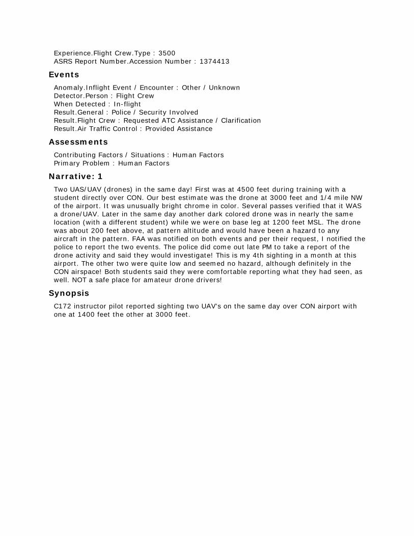
Experience.Flight Crew.Type : 3500
ASRS Report Number.Accession Number : 1374413
Events
Anomaly.Inflight Event / Encounter : Other / Unknown
Detector.Person : Flight Crew
When Detected : In-flight
Result.General : Police / Security Involved
Result.Flight Crew : Requested ATC Assistance / Clarification
Result.Air Traffic Control : Provided Assistance
Assessments
Contributing Factors / Situations : Human Factors
Primary Problem : Human Factors
Narrative: 1
Two UAS/UAV (drones) in the same day! First was at 4500 feet during training with a
student directly over CON. Our best estimate was the drone at 3000 feet and 1/4 mile NW
of the airport. It was unusually bright chrome in color. Several passes verified that it WAS
a drone/UAV. Later in the same day another dark colored drone was in nearly the same
location (with a different student) while we were on base leg at 1200 feet MSL. The drone
was about 200 feet above, at pattern altitude and would have been a hazard to any
aircraft in the pattern. FAA was notified on both events and per their request, I notified the
police to report the two events. The police did come out late PM to take a report of the
drone activity and said they would investigate! This is my 4th sighting in a month at this
airport. The other two were quite low and seemed no hazard, although definitely in the
CON airspace! Both students said they were comfortable reporting what they had seen, as
well. NOT a safe place for amateur drone drivers!
Synopsis
C172 instructor pilot reported sighting two UAV's on the same day over CON airport with
one at 1400 feet the other at 3000 feet.
ACN: 1372635 (38 of 50)
Time / Day
Date : 201607
Local Time Of Day : 1201-1800
Place
Locale Reference.Airport : IAG.Airport
State Reference : NY
Relative Position.Angle.Radial : 060
Relative Position.Distance.Nautical Miles : 3
Altitude.MSL.Single Value : 2000
Environment
Flight Conditions : VMC
Weather Elements / Visibility.Visibility : 10
Light : Daylight
Ceiling.Single Value : 25000
Aircraft : 1
Reference : X
ATC / Advisory.Tower : IAG
Aircraft Operator : FBO
Make Model Name : PA-28 Cherokee/Archer/Dakota/Pillan/Warrior
Crew Size.Number Of Crew : 2
Operating Under FAR Part : Part 91
Flight Plan : None
Mission : Training
Flight Phase : Final Approach
Route In Use : Visual Approach
Route In Use : Direct
Airspace.Class D : IAG
Aircraft : 2
Reference : Y
Make Model Name : UAV - Unpiloted Aerial Vehicle
Flight Phase : Cruise
Airspace.Class D : IAG
Person
Reference : 1
Location Of Person.Aircraft : X
Location In Aircraft : Flight Deck
Reporter Organization : FBO
Function.Flight Crew : Instructor
Qualification.Flight Crew : Instrument
Qualification.Flight Crew : Rotorcraft
Qualification.Flight Crew : Commercial
Qualification.Flight Crew : Flight Instructor
Qualification.Flight Crew : Multiengine
Experience.Flight Crew.Total : 5000

Experience.Flight Crew.Last 90 Days : 120
Experience.Flight Crew.Type : 1415
ASRS Report Number.Accession Number : 1372635
Events
Anomaly.Conflict : NMAC
Detector.Person : Flight Crew
Miss Distance.Horizontal : 10
Miss Distance.Vertical : 20
When Detected : In-flight
Result.Flight Crew : Requested ATC Assistance / Clarification
Result.Air Traffic Control : Provided Assistance
Assessments
Contributing Factors / Situations : Human Factors
Primary Problem : Human Factors
Narrative: 1
Near miss with a drone inside IAG airport traffic area on final approach at 2000 MSL.
Drone passed above by 20 feet and left by 10 feet. Reported event to Niagara Falls tower.
Tower could see the drone via binoculars. They dispatched local authorities to attempt to
locate the operator.
Synopsis
PA28 instructor pilot reported a NMAC with a drone at 2000 feet MSL while on final
approach to IAG Runway 24.
ACN: 1370944 (39 of 50)
Time / Day
Date : 201607
Local Time Of Day : 0601-1200
Place
Locale Reference.Airport : EWR.Airport
State Reference : NJ
Altitude.MSL.Single Value : 2000
Environment
Light : Daylight
Aircraft : 1
Reference : X
ATC / Advisory.Tower : EWR
Make Model Name : BAe 125 Series 800
Crew Size.Number Of Crew : 2
Flight Plan : IFR
Mission : Passenger
Nav In Use.Localizer/Glideslope/ILS : Runway 04R
Flight Phase : Final Approach
Airspace.Class B : EWR
Aircraft : 2
Reference : Y
Make Model Name : UAV - Unpiloted Aerial Vehicle
Flight Phase : Cruise
Airspace.Class B : EWR
Person
Reference : 1
Location Of Person.Aircraft : X
Location In Aircraft : Flight Deck
Function.Flight Crew : Captain
Function.Flight Crew : Pilot Flying
Qualification.Flight Crew : Air Transport Pilot (ATP)
ASRS Report Number.Accession Number : 1370944
Events
Anomaly.Conflict : Airborne Conflict
Detector.Person : Flight Crew
Detector.Person : Air Traffic Control
Miss Distance.Horizontal : 500
Miss Distance.Vertical : 50
When Detected : In-flight
Result.Air Traffic Control : Issued Advisory / Alert
Assessments
Contributing Factors / Situations : Human Factors
Primary Problem : Human Factors
Narrative: 1
On ILS 04R Approach EWR we were informed that a drone was reported in our vicinity. As
ATC was telling us this the PM spotted the white drone 500 feet right of our flight path and
about 50 feet below us. He reported it to ATC along with the color.
Synopsis
BAE125 Captain reported being informed by ATC of a drone in the vicinity of the EWR ILS
Runway 04R before sighting it 500 feet to the right of the localizer.
ACN: 1370646 (40 of 50)
Time / Day
Date : 201607
Local Time Of Day : 1201-1800
Place
Locale Reference.Airport : FDW.Airport
State Reference : SC
Altitude.AGL.Single Value : 200
Environment
Flight Conditions : VMC
Weather Elements / Visibility.Visibility : 10
Light : Daylight
Aircraft : 1
Reference : X
ATC / Advisory.CTAF : FDW
Aircraft Operator : Government
Make Model Name : UAV - Unpiloted Aerial Vehicle
Operating Under FAR Part : Part 91
Flight Plan : VFR
Mission : Utility
Flight Phase : Final Approach
Airspace.Class G : FDW
Aircraft : 2
Reference : Y
ATC / Advisory.CTAF : FDW
Aircraft Operator : Personal
Make Model Name : Beechcraft Single Piston Undifferentiated or Other Model
Crew Size.Number Of Crew : 1
Operating Under FAR Part : Part 91
Flight Plan : None
Mission : Personal
Flight Phase : Initial Climb
Route In Use : None
Airspace.Class G : FDW
Person
Reference : 1
Location Of Person : Gate / Ramp / Line
Reporter Organization : Government
Function.Flight Crew : Pilot Flying
Function.Flight Crew : Single Pilot
Qualification.Flight Crew : Multiengine
Qualification.Flight Crew : Commercial
Qualification.Flight Crew : Instrument
Experience.Flight Crew.Total : 2200
Experience.Flight Crew.Last 90 Days : 5
Experience.Flight Crew.Type : 5
ASRS Report Number.Accession Number : 1370646
Human Factors : Communication Breakdown
Communication Breakdown.Party1 : Flight Crew
Communication Breakdown.Party2 : Flight Crew
Events
Anomaly.Conflict : Airborne Conflict
Detector.Person : Flight Crew
Miss Distance.Horizontal : 500
Miss Distance.Vertical : 100
When Detected : In-flight
Result.Flight Crew : Took Evasive Action
Assessments
Contributing Factors / Situations : Human Factors
Primary Problem : Human Factors
Narrative: 1
While conducting a UAV mapping flight of Runway 4 at FDW the UAV was nearing end of
mission when the low battery indication was noted. During approach to landing a
Beechcraft Bonanza announced departure from Runway 22. Evasive actions were taken to
descend from 900 feet MSL to get the UAV on the ground ASAP. The departing Bonanza
held the aircraft low while departing. CTAF calls were made to the departing aircraft of
position and altitude of the UAV but received no response. UAV aircraft was recovered
without incident.
Synopsis
UAV pilot conducting a mapping flight of FDW Runway 4 reported a low battery light and a
quick return to Runway 4 using CTAF procedures with a hand held VHF radio. A Bonanza
announced departing Runway 22, but does not acknowledge the UAV pilot. Evasive action
was taken by the UAV pilot.

ACN: 1370512 (41 of 50)
Time / Day
Date : 201607
Local Time Of Day : 1201-1800
Place
Locale Reference.Airport : ORD.Airport
State Reference : IL
Altitude.MSL.Single Value : 3000
Environment
Flight Conditions : VMC
Light : Daylight
Ceiling.Single Value : 5000
Aircraft : 1
Reference : X
ATC / Advisory.Tower : ORD
Aircraft Operator : Air Carrier
Make Model Name : EMB ERJ 145 ER/LR
Crew Size.Number Of Crew : 2
Operating Under FAR Part : Part 121
Flight Plan : IFR
Mission : Passenger
Flight Phase : Final Approach
Airspace.Class B : ORD
Aircraft : 2
Reference : Y
Make Model Name : UAV - Unpiloted Aerial Vehicle
Flight Phase : Cruise
Airspace.Class B : ORD
Person : 1
Reference : 1
Location Of Person.Aircraft : X
Location In Aircraft : Flight Deck
Reporter Organization : Air Carrier
Function.Flight Crew : First Officer
Function.Flight Crew : Pilot Not Flying
Qualification.Flight Crew : Air Transport Pilot (ATP)
ASRS Report Number.Accession Number : 1370512
Person : 2
Reference : 2
Location Of Person.Aircraft : X
Location In Aircraft : Flight Deck
Reporter Organization : Air Carrier
Function.Flight Crew : Captain
Function.Flight Crew : Pilot Flying
Qualification.Flight Crew : Air Transport Pilot (ATP)
ASRS Report Number.Accession Number : 1370510
Events
Anomaly.Conflict : Airborne Conflict
Detector.Automation : Aircraft RA
Detector.Person : Flight Crew
Miss Distance.Vertical : 400
When Detected : In-flight
Result.Flight Crew : Requested ATC Assistance / Clarification
Assessments
Contributing Factors / Situations : Human Factors
Primary Problem : Human Factors
Narrative: 1
We were on final approach for 9L over DOOGY at 3000 feet we got a traffic alert and then
a monitor vertical speed for traffic below us at 2,500 feet. We did not get a climb or
descent, we did not deviate from anything assigned to us. But we did report to Chicago
tower that there was a drone below our aircraft.
The only threat we had was that we could have possibly collided with the drone and
possibly an unstable approach from trying to find the drone and trying to figure out what it
was but we did not have any errors associated with this situation.
Narrative: 2
We received a TCAS RA while operating flight to ORD. The event occurred while on final
approach for 9L. I was the pilot flying and had the autopilot engaged while the aircraft was
captured on the 9L localizer. We were at our last assigned altitude of 3,000 feet and
cleared the visual approach for 9L over the DOOGY fix (10.3 DME) when we received the
TCAS TA. The FO, acting as the pilot monitoring, had the TCAS display up at a range of 12
miles. At the time the traffic advisory was issued the FO looked outside his side window to
locate the traffic visually. While the FO was looking out the window I adjusted the TCAS
display to 6 miles to get a better idea of the aircraft location. The FO visually acquired the
aircraft causing the TA and informed me that it appeared to be a black multi-rotor drone.
According to the TCAS display, the traffic appeared to be at our 4 o'clock position, 500 feet
below and closing. Immediately afterwards we received a TCAS RA. The RA command was
to "monitor vertical speed." The autopilot was still engaged and holding 3,000 feet. I
elected to leave the autopilot engaged because the glideslope was not alive. The approach
mode was armed, but we were just inside the DOOGY fix and a few miles from glide
intercept. I held my thumb over the disconnect button and monitored the VS and
glideslope. The RA was active for approximately 4 seconds. The RA did not require us to
vacate our last assigned altitude so we did not notify approach of the RA. The FO
maintained visual of the aircraft during the RA and until it was clear of us. The FO reported
the traffic's approximate location and altitude (2,500 feet near DOOGY) to approach
control. We continued the approach and landing without any further disruptions.
I believe one threat that occurred during this event is that we were cleared the approach
at 3,000 feet over DOOGY. The altitude over DOOGY on the 21-3 plate is 4,000 feet.
Approach control's instruction to descend to 3,000 put us at the bottom of the Class B
shelf at that location. This increases the possibility of getting close to VFR traffic operating
just below class B. Another threat was that approach did not advise us of the traffic. One
error that I made was leaving the approach mode engaged. In hindsight, I think I should
have armed the Nav mode once we received the RA command to "maintain vertical speed"
to prevent the glide from capturing and descending towards the traffic. We also should
have advised approach control of the RA even though it did not require us deviate from
our altitude.
Synopsis
EMB145 flight crew reported a possible drone sighting at 3,000 feet over DOOGY on
approach to ORD Runway 9L. A TCAS RA was generated to, "Monitor Vertical Speed" for
the traffic 500 feet below.
ACN: 1369666 (42 of 50)
Time / Day
Date : 201607
Local Time Of Day : 0601-1200
Place
Locale Reference.Airport : PHX.Airport
State Reference : AZ
Altitude.AGL.Single Value : 500
Environment
Flight Conditions : VMC
Light : Daylight
Aircraft : 1
Reference : X
ATC / Advisory.Tower : PHX
Make Model Name : Small Aircraft, Low Wing, 1 Eng, Retractable Gear
Crew Size.Number Of Crew : 1
Flight Plan : IFR
Flight Phase : Final Approach
Airspace.Class B : PHX
Aircraft : 2
Reference : Y
Make Model Name : UAV - Unpiloted Aerial Vehicle
Flight Phase : Cruise
Airspace.Class B : PHX
Person
Reference : 1
Location Of Person.Aircraft : X
Location In Aircraft : Flight Deck
Function.Flight Crew : Single Pilot
Function.Flight Crew : Pilot Flying
Qualification.Flight Crew : Air Transport Pilot (ATP)
ASRS Report Number.Accession Number : 1369666
Human Factors : Distraction
Events
Anomaly.Conflict : Airborne Conflict
Anomaly.Inflight Event / Encounter : Other / Unknown
Detector.Person : Flight Crew
Miss Distance.Horizontal : 50
Miss Distance.Vertical : 50
When Detected : In-flight
Result.Flight Crew : Requested ATC Assistance / Clarification
Assessments
Contributing Factors / Situations : Airspace Structure
Contributing Factors / Situations : Environment - Non Weather Related
Primary Problem : Ambiguous
Narrative: 1
While approaching 25L at PHX I encountered a drone at approximately 500-700 feet AGL.
I made a radio call to the tower reporting it, and the tower replied that they could also see
it visually. It appeared to be about 50 feet high and to the right of the airplane. It was
black, with 4 motors. Roughly the size of a microwave. I did not have to take evasive
action, and landed without incident.
Synopsis
The pilot of a single engine transport aircraft reported seeing a UAV while on final
approach to PHX Runway 25L. No evasive action was required and, after reporting the
sighting to the Tower, he landed without incident.
ACN: 1369662 (43 of 50)
Time / Day
Date : 201607
Local Time Of Day : 0601-1200
Place
Locale Reference.Airport : ORD.Airport
State Reference : IL
Altitude.MSL.Single Value : 1300
Environment
Flight Conditions : VMC
Light : Daylight
Aircraft : 1
Reference : X
ATC / Advisory.Tower : ORD
Aircraft Operator : Air Carrier
Make Model Name : B737-800
Crew Size.Number Of Crew : 2
Operating Under FAR Part : Part 121
Flight Plan : IFR
Mission : Passenger
Flight Phase : Final Approach
Airspace.Class B : ORD
Aircraft : 2
Reference : Y
Make Model Name : UAV - Unpiloted Aerial Vehicle
Flight Phase : Cruise
Airspace.Class B : ORD
Person
Reference : 1
Location Of Person.Aircraft : X
Location In Aircraft : Flight Deck
Reporter Organization : Air Carrier
Function.Flight Crew : Captain
Qualification.Flight Crew : Air Transport Pilot (ATP)
ASRS Report Number.Accession Number : 1369662
Human Factors : Distraction
Human Factors : Workload
Human Factors : Situational Awareness
Events
Anomaly.Conflict : Airborne Conflict
Anomaly.Deviation - Procedural : FAR
Detector.Person : Flight Crew
When Detected : In-flight
Result.Flight Crew : Requested ATC Assistance / Clarification
Assessments
Contributing Factors / Situations : Human Factors
Contributing Factors / Situations : Procedure
Primary Problem : Human Factors
Narrative: 1
Spotted drone approximately 2.5 mile final 27L at 1300 MSL about 1 mile south of course.
Notified ATC and dispatch.
Synopsis
Air carrier Captain reported a UAS 1 mile south of ORD Runway 27L at 1,300 ft on a 2.5
mile final.
ACN: 1368165 (44 of 50)
Time / Day
Date : 201606
Local Time Of Day : 0601-1200
Place
Locale Reference.Airport : LAX.Airport
State Reference : CA
Altitude.MSL.Single Value : 1000
Environment
Flight Conditions : VMC
Light : Daylight
Aircraft : 1
Reference : X
ATC / Advisory.Tower : LAX
Aircraft Operator : Air Carrier
Make Model Name : Large Transport, Low Wing, 2 Turbojet Eng
Crew Size.Number Of Crew : 2
Operating Under FAR Part : Part 121
Flight Plan : IFR
Mission : Passenger
Nav In Use : FMS Or FMC
Nav In Use : GPS
Nav In Use.Localizer/Glideslope/ILS : Runway 25L
Flight Phase : Initial Approach
Airspace.Class B : LAX
Aircraft : 2
Reference : Y
Make Model Name : UAV - Unpiloted Aerial Vehicle
Flight Phase : Cruise
Airspace.Class B : LAX
Person
Reference : 1
Location Of Person.Aircraft : X
Location In Aircraft : Flight Deck
Reporter Organization : Air Carrier
Function.Flight Crew : Pilot Flying
Function.Flight Crew : Captain
Qualification.Flight Crew : Air Transport Pilot (ATP)
ASRS Report Number.Accession Number : 1368165
Human Factors : Distraction
Human Factors : Situational Awareness
Events
Anomaly.Conflict : Airborne Conflict
Detector.Person : Flight Crew
When Detected : In-flight
Result.General : None Reported / Taken
Assessments
Contributing Factors / Situations : Human Factors
Contributing Factors / Situations : Procedure
Primary Problem : Human Factors
Narrative: 1
While on the ILS 25L, my FO stated, "Is that a bird?" and pointed to the left side of the
aircraft. As I turned to look at what the FO was pointing at, he stated that he saw a UAV of
some sort to the left of the approach course. I did not see the object.
Synopsis
Air carrier Captain reported that the First Officer saw a UAS off the aircraft's left on
approach to LAX. The Captain did not see it.
ACN: 1367986 (45 of 50)
Time / Day
Date : 201606
Local Time Of Day : 0601-1200
Place
Locale Reference.Airport : OAK.Airport
State Reference : CA
Altitude.MSL.Single Value : 5000
Environment
Flight Conditions : VMC
Light : Daylight
Aircraft : 1
Reference : X
ATC / Advisory.TRACON : NCT
Aircraft Operator : Air Carrier
Make Model Name : Widebody, Low Wing, 3 Turbojet Eng
Crew Size.Number Of Crew : 2
Operating Under FAR Part : Part 121
Flight Plan : IFR
Mission : Cargo / Freight
Nav In Use : FMS Or FMC
Flight Phase : Initial Approach
Route In Use : Vectors
Airspace.Class E : NCT
Aircraft : 2
Reference : Y
Make Model Name : UAV - Unpiloted Aerial Vehicle
Flight Phase : Cruise
Airspace.Class E : NCT
Person
Reference : 1
Location Of Person.Aircraft : X
Location In Aircraft : Flight Deck
Reporter Organization : Air Carrier
Function.Flight Crew : Captain
Function.Flight Crew : Pilot Flying
Qualification.Flight Crew : Air Transport Pilot (ATP)
ASRS Report Number.Accession Number : 1367986
Human Factors : Distraction
Events
Anomaly.Conflict : NMAC
Anomaly.Deviation - Procedural : Published Material / Policy
Anomaly.Deviation - Procedural : FAR
Detector.Person : Flight Crew
When Detected : In-flight
Result.Flight Crew : Requested ATC Assistance / Clarification
Assessments
Contributing Factors / Situations : Human Factors
Contributing Factors / Situations : Procedure
Primary Problem : Human Factors
Narrative: 1
Vectors on approach to OAK over the town of Pleasanton, CA at 5,000 feet. Near miss with
a white drone. Advised ATC of the event.
Get those things out of the sky!
Synopsis
Air carrier Captain reported a near miss with a UAV at 5,000 ft over Pleasanton, CA.
ACN: 1367012 (46 of 50)
Time / Day
Date : 201606
Local Time Of Day : 1201-1800
Place
Locale Reference.Airport : 3CK.Airport
State Reference : IL
Altitude.AGL.Single Value : 1000
Environment
Flight Conditions : VMC
Light : Daylight
Aircraft : 1
Reference : X
ATC / Advisory.CTAF : 3CK
Aircraft Operator : Personal
Make Model Name : Small Aircraft, High Wing, 1 Eng, Fixed Gear
Crew Size.Number Of Crew : 1
Operating Under FAR Part : Part 91
Flight Plan : None
Mission : Personal
Flight Phase : Initial Climb
Route In Use : Direct
Airspace.Class E : C90
Aircraft : 2
Reference : Y
Make Model Name : UAV - Unpiloted Aerial Vehicle
Flight Phase : Cruise
Airspace.Class E : C90
Person
Reference : 1
Location Of Person.Aircraft : X
Location In Aircraft : Flight Deck
Reporter Organization : Personal
Function.Flight Crew : Pilot Flying
Function.Flight Crew : Single Pilot
Qualification.Flight Crew : Flight Instructor
Qualification.Flight Crew : Air Transport Pilot (ATP)
Qualification.Flight Crew : Multiengine
Qualification.Flight Crew : Instrument
Experience.Flight Crew.Total : 3850
Experience.Flight Crew.Last 90 Days : 5
Experience.Flight Crew.Type : 500
ASRS Report Number.Accession Number : 1367012
Human Factors : Workload
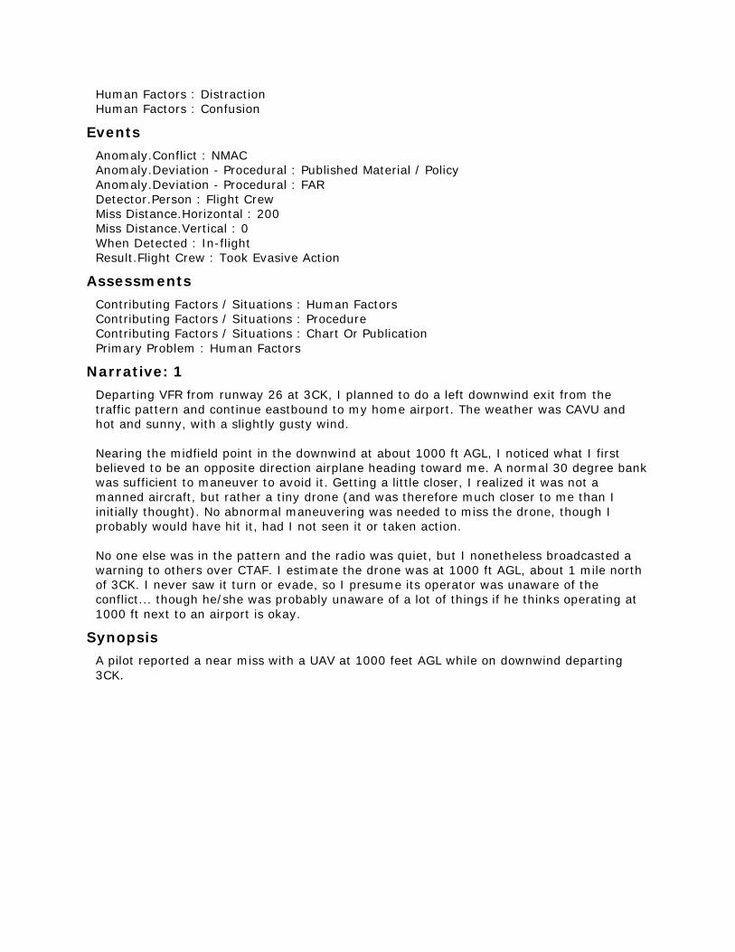
Human Factors : Distraction
Human Factors : Confusion
Events
Anomaly.Conflict : NMAC
Anomaly.Deviation - Procedural : Published Material / Policy
Anomaly.Deviation - Procedural : FAR
Detector.Person : Flight Crew
Miss Distance.Horizontal : 200
Miss Distance.Vertical : 0
When Detected : In-flight
Result.Flight Crew : Took Evasive Action
Assessments
Contributing Factors / Situations : Human Factors
Contributing Factors / Situations : Procedure
Contributing Factors / Situations : Chart Or Publication
Primary Problem : Human Factors
Narrative: 1
Departing VFR from runway 26 at 3CK, I planned to do a left downwind exit from the
traffic pattern and continue eastbound to my home airport. The weather was CAVU and
hot and sunny, with a slightly gusty wind.
Nearing the midfield point in the downwind at about 1000 ft AGL, I noticed what I first
believed to be an opposite direction airplane heading toward me. A normal 30 degree bank
was sufficient to maneuver to avoid it. Getting a little closer, I realized it was not a
manned aircraft, but rather a tiny drone (and was therefore much closer to me than I
initially thought). No abnormal maneuvering was needed to miss the drone, though I
probably would have hit it, had I not seen it or taken action.
No one else was in the pattern and the radio was quiet, but I nonetheless broadcasted a
warning to others over CTAF. I estimate the drone was at 1000 ft AGL, about 1 mile north
of 3CK. I never saw it turn or evade, so I presume its operator was unaware of the
conflict... though he/she was probably unaware of a lot of things if he thinks operating at
1000 ft next to an airport is okay.
Synopsis
A pilot reported a near miss with a UAV at 1000 feet AGL while on downwind departing
3CK.
ACN: 1365558 (47 of 50)
Time / Day
Date : 201606
Local Time Of Day : 0601-1200
Place
Locale Reference.Airport : EWR.Airport
State Reference : NJ
Altitude.MSL.Single Value : 420
Environment
Flight Conditions : VMC
Light : Daylight
Aircraft : 1
Reference : X
ATC / Advisory.Tower : EWR
Aircraft Operator : Air Carrier
Make Model Name : Large Transport, Low Wing, 2 Turbojet Eng
Crew Size.Number Of Crew : 2
Operating Under FAR Part : Part 121
Flight Plan : IFR
Mission : Passenger
Nav In Use : FMS Or FMC
Nav In Use.Localizer/Glideslope/ILS : Runway 22L
Flight Phase : Final Approach
Airspace.Class B : EWR
Aircraft : 2
Reference : Y
Aircraft Operator : Personal
Make Model Name : UAV - Unpiloted Aerial Vehicle
Operating Under FAR Part.Other
Flight Phase : Cruise
Airspace.Class B : EWR
Person : 1
Reference : 1
Location Of Person.Aircraft : X
Location In Aircraft : Flight Deck
Reporter Organization : Air Carrier
Function.Flight Crew : Captain
Function.Flight Crew : Pilot Not Flying
Qualification.Flight Crew : Air Transport Pilot (ATP)
ASRS Report Number.Accession Number : 1365558
Human Factors : Distraction
Human Factors : Situational Awareness
Human Factors : Workload
Person : 2
Reference : 2
Location Of Person.Aircraft : X
Location In Aircraft : Flight Deck
Reporter Organization : Air Carrier
Function.Flight Crew : First Officer
Function.Flight Crew : Pilot Flying
Qualification.Flight Crew : Air Transport Pilot (ATP)
Experience.Flight Crew.Type : 423
ASRS Report Number.Accession Number : 1365881
Human Factors : Workload
Human Factors : Distraction
Human Factors : Situational Awareness
Events
Anomaly.Airspace Violation : All Types
Anomaly.Conflict : Airborne Conflict
Anomaly.Deviation - Procedural : FAR
Detector.Person : Flight Crew
When Detected : In-flight
Result.Flight Crew : Became Reoriented
Assessments
Contributing Factors / Situations : Human Factors
Contributing Factors / Situations : Environment - Non Weather Related
Contributing Factors / Situations : Procedure
Primary Problem : Human Factors
Narrative: 1
While flying the ILS 22L into EWR we heard an aircraft in front of us report that "They may
have just flown past a drone". The tower then asked us to be sure we heard the report. I
was the Pilot monitoring so was looking intently for the drone. At about 420 MSL the drone
came into sight above and to the right of our flight path. The FO also had it in sight and no
deviations were needed. It all happened very fast and the object was quite a blur. It
appeared to be brown or grey in color and the outline of circular rotor blades visible. Size,
speed and direction of travel impossible to tell. It appeared stationary from my perspective
but may be because of the large speed differential. We landed completely normally other
than spotting the drone. We verbally reported to the tower and also were met by police
who wanted a description as well.
Narrative: 2
The aicraft was stable and the drone was not in our immediate Flight Path as it was to the
right and above us. The CA filed a report to capture the details for the company.
Synopsis
An air carrier crew was notified by EWR Tower about an earlier UAS sighting. They also
detected the UAS at about 420 feet, but the craft's details were difficult to determine.
ACN: 1365320 (48 of 50)
Time / Day
Date : 201606
Local Time Of Day : 1201-1800
Place
Locale Reference.Airport : ORF.Airport
State Reference : VA
Altitude.MSL.Single Value : 10000
Environment
Flight Conditions : VMC
Light : Daylight
Aircraft : 1
Reference : X
ATC / Advisory.Center : ZDC
Aircraft Operator : Air Carrier
Make Model Name : EMB ERJ 170/175 ER/LR
Crew Size.Number Of Crew : 2
Operating Under FAR Part : Part 121
Flight Plan : IFR
Mission : Passenger
Nav In Use : FMS Or FMC
Flight Phase : Climb
Airspace.Class E : ZDC
Aircraft : 2
Reference : Y
Make Model Name : UAV - Unpiloted Aerial Vehicle
Flight Phase : Cruise
Airspace.Class E : ZDC
Person
Reference : 1
Location Of Person.Aircraft : X
Location In Aircraft : Flight Deck
Reporter Organization : Air Carrier
Function.Flight Crew : Captain
Function.Flight Crew : Pilot Not Flying
Qualification.Flight Crew : Air Transport Pilot (ATP)
ASRS Report Number.Accession Number : 1365320
Human Factors : Other / Unknown
Analyst Callback : Completed
Events
Anomaly.Conflict : NMAC
Anomaly.Deviation - Procedural : FAR
Detector.Person : Passenger
Were Passengers Involved In Event : Y
When Detected : In-flight
Result.General : None Reported / Taken
Assessments
Contributing Factors / Situations : Environment - Non Weather Related
Contributing Factors / Situations : Human Factors
Contributing Factors / Situations : Procedure
Primary Problem : Human Factors
Narrative: 1
Passenger reported seeing a large drone flying just near the wingtip of the airplane. Drone
was described as 3 feet in length, dark grey in color and spherical in shape. Stated that it
had an arm with a camera and a green blinking light and just missed the wing of the
airplane on the right hand side. Altitude was approximately 17,000 ft when it was reported
to the crew.
Callback: 1
The reporter stated his altitude was 17,000 ft when notified by the Flight Attendant about
the UAS. The encounter may had been much lower but the report delayed because of the
sterile cockpit procedure. The Flight Attendant believed the passenger knew what he was
talking about and believed the UAS flew formation with the aircraft which at the time was
climbing at 230 kts.
Synopsis
An EMB-175 Captain reported being advised by a Flight Attendant that a passenger
witnessed a dark grey, spherically shaped UAS three feet long flew near their aircraft's
wingtip at some point during departure.
ACN: 1364983 (49 of 50)
Time / Day
Date : 201606
Local Time Of Day : 1201-1800
Place
Locale Reference.ATC Facility : NHK.TRACON
State Reference : MD
Altitude.MSL.Single Value : 7000
Environment
Flight Conditions : VMC
Weather Elements / Visibility.Visibility : 20
Light : Daylight
Aircraft : 1
Reference : X
ATC / Advisory.TRACON : NHK
Aircraft Operator : Air Taxi
Make Model Name : Light Transport, Low Wing, 2 Turbojet Eng
Crew Size.Number Of Crew : 2
Operating Under FAR Part : Part 135
Flight Plan : IFR
Mission : Passenger
Nav In Use : FMS Or FMC
Nav In Use : GPS
Flight Phase : Initial Approach
Route In Use : Visual Approach
Route In Use : Direct
Airspace.Class E : NHK
Aircraft : 2
Reference : Y
Make Model Name : UAV - Unpiloted Aerial Vehicle
Operating Under FAR Part : Part 91
Flight Phase : Cruise
Airspace.Class E : NHK
Person
Reference : 1
Location Of Person.Aircraft : X
Location In Aircraft : Flight Deck
Reporter Organization : Air Taxi
Function.Flight Crew : Pilot Not Flying
Function.Flight Crew : First Officer
Qualification.Flight Crew : Air Transport Pilot (ATP)
Qualification.Flight Crew : Multiengine
Experience.Flight Crew.Total : 14280
Experience.Flight Crew.Last 90 Days : 78
Experience.Flight Crew.Type : 4650
ASRS Report Number.Accession Number : 1364983
Human Factors : Confusion
Human Factors : Distraction
Human Factors : Situational Awareness
Human Factors : Communication Breakdown
Communication Breakdown.Party1 : Flight Crew
Communication Breakdown.Party2 : ATC
Analyst Callback : Completed
Events
Anomaly.Airspace Violation : All Types
Anomaly.ATC Issue : All Types
Anomaly.Conflict : NMAC
Anomaly.Deviation - Procedural : FAR
Detector.Person : Flight Crew
Miss Distance.Horizontal : 300
Miss Distance.Vertical : 300
When Detected : In-flight
Result.Flight Crew : Requested ATC Assistance / Clarification
Assessments
Contributing Factors / Situations : Environment - Non Weather Related
Contributing Factors / Situations : Human Factors
Contributing Factors / Situations : Procedure
Primary Problem : Human Factors
Narrative: 1
Initially, I was looking inside the cockpit performing NFP pre-landing duties. PIC startled
me as he brought my attention outside. I looked up in time enough to see the drone,
shining and stable passing less than 300 feet off the starboard side. It might have been
about 5 feet in length. It passed less than 300 feet below us. My gut is that it may have
been as close as 150 below and 200 starboard. I immediately called TRACON, but she was
occupied and delayed in responding to me. When I got her attention I reported us having
passed a drone; the controller did not seem concerned and did not ask any questions. I
even asked that she copied my report - she acknowledged and went on about her duties.
My fellow pilot and I later debriefed on the incident and agreed that it was a drone, it
appeared gray and black, maybe with white, and we agreed on our estimations of the
approximate position of it passing our aircraft.
A cursory search does not avail a drone reporting system, and I would suggest that either
one be created or that this ASRS system provide accounting for drones. I would like to
know what if anything can be confirmed about this incident, and express my serious
concern for a drone at 6800 MSL, unreported, without TCAS, and passing so close to
manned aircraft.
Callback: 1
The reporter stated their destination was SBY. NHK TRACON showed no interest in filing
information about this event. The reporter stated he was very angry at the Controller's
attitude.
Synopsis

Light Jet Air taxi First Officer reported a near miss with a UAV at 7,000 ft while flying a
straight in visual approach to SBY Runway 14. TRACON Controller showed no interest in
the event.
ACN: 1364948 (50 of 50)
Time / Day
Date : 201606
Local Time Of Day : 1801-2400
Place
Locale Reference.Airport : ZZZ.Airport
State Reference : US
Altitude.AGL.Single Value : 206
Environment
Flight Conditions : VMC
Weather Elements / Visibility.Visibility : 10
Light : Daylight
Aircraft
Reference : X
Aircraft Operator : Personal
Make Model Name : UAV - Unpiloted Aerial Vehicle
Operating Under FAR Part.Other
Flight Plan : None
Mission : Personal
Flight Phase : Cruise
Route In Use : Direct
Airspace.Class G : ZZZ
Component
Aircraft Component : Navigational Equipment and Processing
Aircraft Reference : X
Problem : Malfunctioning
Person
Reference : 1
Location Of Person.Aircraft : X
Reporter Organization : Personal
Function.Flight Crew : Pilot Flying
Function.Flight Crew : Single Pilot
Qualification.Flight Crew : Instrument
Qualification.Flight Crew : Commercial
Experience.Flight Crew.Total : 3374
Experience.Flight Crew.Last 90 Days : 7
Experience.Flight Crew.Type : 1042
ASRS Report Number.Accession Number : 1364948
Human Factors : Human-Machine Interface
Events
Anomaly.Inflight Event / Encounter : Object
Detector.Person : Other Person
Were Passengers Involved In Event : N
When Detected : In-flight
Result.Aircraft : Aircraft Damaged
Assessments
Contributing Factors / Situations : Aircraft
Primary Problem : Aircraft
Narrative: 1
I was leisurely taking pictures of the sunset and the lights around the cathedral with my
DJI Inspire 1 Pro drone. After approximately 7 minutes of flight with approximately 5+
minutes left of flight and 58% battery life and visual contact the UAS lost signal with the
ground control unit and "disconnected". It was last visually seen above a parking lot. At
this point I initiated lost signal procedures to return the UAS at 400 feet to home. After
approximately 10 minutes I considered it a flyaway. I had my wife stay at the home
(return) location as I looked for the UAS and looked until [late that night] and did not
recover the UAS. I called the local PD and made a lost property report at that time. [Three
days later] I received a call from a police detective saying that they had recovered the
drone but would not release it or any information until [2 days later]. When I met with the
detective she informed me that there was no injury but approximately $500 in property
damage occurred (broken window) in an unoccupied space and fell 25 stories with no
injury to people. She also indicated that there were no local laws broken or punitive
measure taken. The drone had been totaled and she released it back to me at this time. I
met with the property owner of the [building] and gave him my insurance info.
Synopsis
A DJI Inspire 1 Pro UAS owner lost communication with the aircraft which then did not
return "home" but hit a tall building destroying the UAS and breaking a window 25 stories
up.