unc charlotte foundation property marketing package
TRANSCRIPT
0
htt p://bunker. iscrow .synology.me/im ages/.gifhtt p://bun ker.synology.me/images/t opbar.gif
Union County, N.C.
in Rapidly-Growing
Charlotte MSA
__________
Zoned R-40 Single-
Family
-----------------
Outstanding School
District
__________
4th Highest Income
Census Tract in
Charlotte MSA
__________
Proximity to Shopping,
Parks, & Other
Amenities
_________
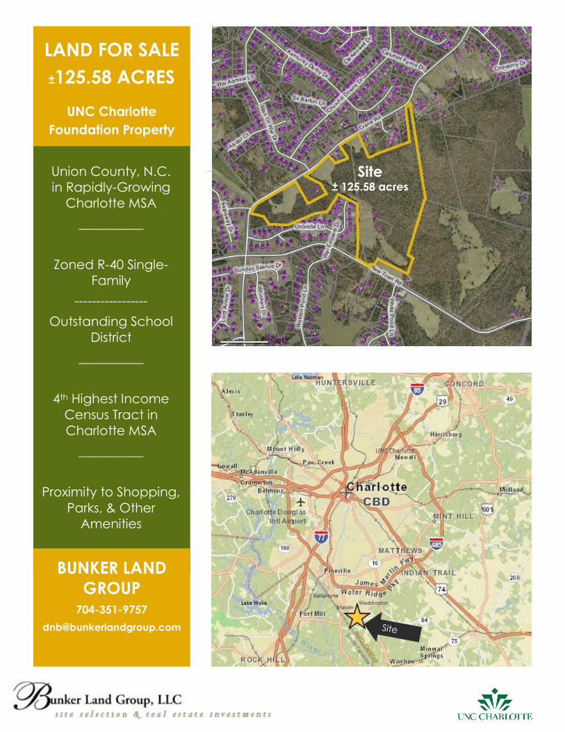
LAND FOR SALE
±125.58 ACRES
UNC Charlotte
Foundation Property
BUNKER LAND
GROUP 704-351-9757
Site ± 125.58 acres
1
TABLE OF CONTENTS
EXECUTIVE SUMMARY ...……………………………………………………………………………………………………………. 2
ECONOMIC DEVELOPMENT……………………………………………………………………………………………………….. 3
HOUSING PROFILE IN FIVE MILE RING ……………………………………………………………………………………………. 4
PROPERTY OVERVIEW ………………………………………………………………………………………………………...…..... 8
GENERAL DESCRIPTION AND LOCATION ……………………………………………………………………………………..… 8
PHYSICAL CHARACTERISTICS OF THE SITE ……………………………………………………………………………………..… 9
FLOOD PLAIN ………………………………………………………………………………………………………………..……….. 9
UTILITIES ………………………………………………………………………………………………………………...…..……….... 10
SCHOOLS……………………………………………………………………………………………………………………...……… 11
PROPERTY TAXES……………………………………………………………………………………………………………….…….. 11
MUNICIPAL BOUNDARIES…………………………………………………………………………………………………….…….. 12
ZONING……………………………………………………………………………………………………………………….……..... 13
DISCLAIMERS………………………………………………………………………………………………………………….…...…. 14
ADDENDUM…………………………………………………………………………………………………………………….…..… 15
CONCEPTUAL SITE PLAN ………………………………………………………………………………………………………...… 16
LIMITED RISK ASSESSMENT: PHASE I……………………………………………………………………………………….…......… 17
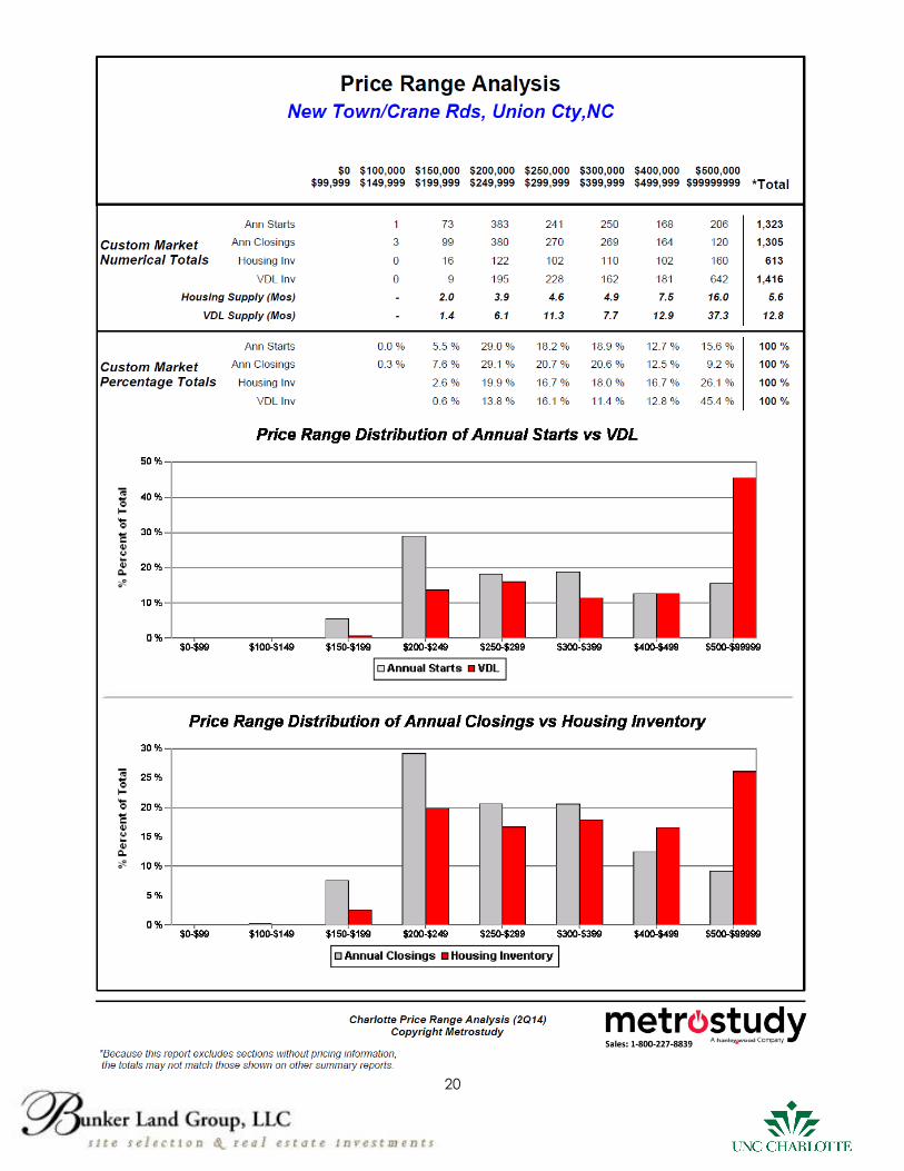
PRICE RANGE ANALYSIS…………………………………………………………………………………………………….……... 20
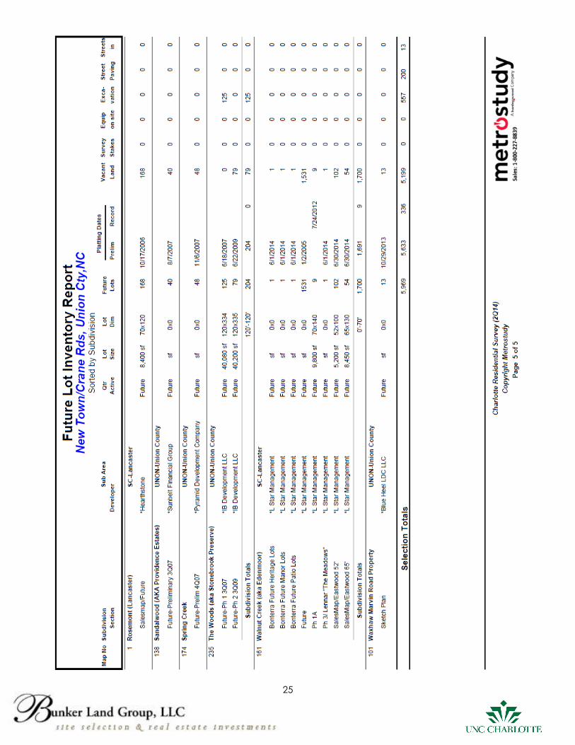
FUTURE LOT INVENTORY REPORT……………………………………………………………………………………….….……… 21
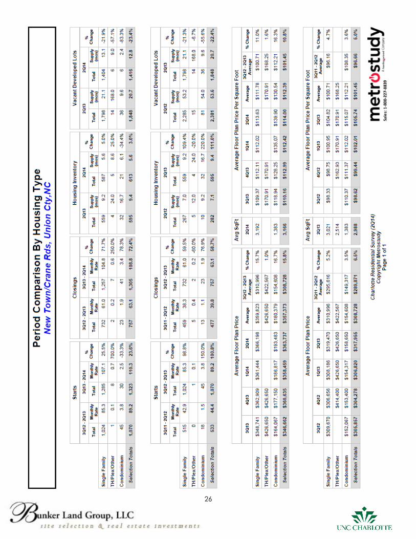
PERIOD COMPARISON BY HOUSING TYPE…………………………………………………………………….…………….….. 26
BROCHURE: Working With Real Estate Agents……………………………………………………………….…………….…. 27
2
UNC CHARLOTTE FOUNDATION PROPERTY EXECUTIVE SUMMARY
Bunker Land Group, LLC has been engaged to exclusively represent the UNC Charlotte Foundation in
the sale of a ±125.58 acre tract of undeveloped land in Union County, North Carolina (Charlotte MSA).
The property was gifted to the Foundation by Dr. Gage in January, 2005 with restrictions that it could
not be developed for a period of time. This restriction encumbers the property until September 5, 2016.
Any sale prior to September 5, 2016 would be subject to this restriction.
LOCATION
The property is located at the intersection of New Town and Crane Roads within the jurisdiction of Union
County and in the highly desirable Marvin School District. This area of Union County is currently a very
active target acquisition area for numerous homebuilders due to the high income demographics, low
land supply, and excellent schools. Currently, there is a great deal of activity and momentum in this
submarket by builders and developers to acquire developed lots and undeveloped tracts of land.
ZONING
The property is zoned R-40, which allows for a minimum lot size of 40,000 square feet. The County Land
Use Ordinance also has a provision for clustering (20,000-square foot minimum). Surrounding the
property to the north, west, and south are predominantly single family subdivisions, also zoned R-40. Lot
sizes for the surrounding subdivisions range from less than 20,000 square feet to large estate lots well
over one acre. Directly adjacent to the property to the east are undeveloped parcels zoned
Residential Conservation District (RCD) by the Town of Weddington. Similar to the Union County R-40
Zoning Classification, minimum lots sizes in the RCD district are 40,000 square feet, unless developed as
a conservation subdivision.
HOUSING MARKET CHARACTERISTICS
We invite your attention to the Metrostudy 2nd Quarter, 2014, Housing Profile in Five Mile Ring Study (pg.
4-7). There are 52 active subdivisions in the study area. Approximately 20 subdivisions have sales activity
from $500,000 up. Most of the remaining neighborhoods have sales activity in the $300,000-$500,000
range. The Total Supply of housing is 5.6 months (6-8 month’s supply is historically considered Equilibrium
for the Charlotte market). The VDL Supply (supply of vacant developed lots) is 12.8 months (24-30
month’s supply is historically considered Equilibrium for the Charlotte market). Finally, the Annual Lots
Delivered compared to Annual Housing Starts indicates a trend of demand exceeding supply. 891 lots
were delivered in the four previous quarters (2nd Qtr. 2013-2nd Qtr. 2014) and 1,323 houses were started
in those same four quarters. Additionally, a Price Range Analysis Report, Future Lot Inventory Report,
and Period Comparison by Housing Type Report are included in the Addendum.
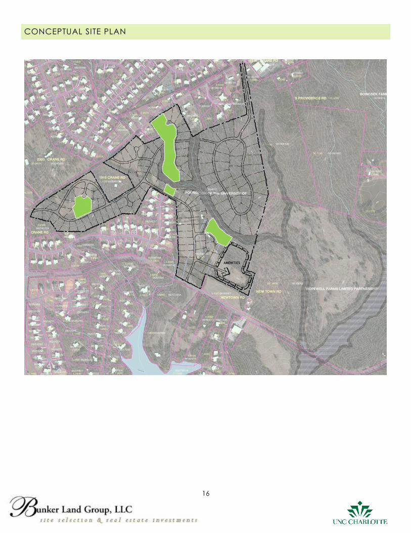
DEVELOPMENT OPPORTUNITY
The highest and best use of the land is an upscale residential subdivision comparable to other
communities found in the submarket. A Conceptual Site Plan and Limited Risk Assessment- Phase I can
be found in the Addendum.
Note: 1) Pricing of the offering “To Be Determined” by the Market
2) Best and Final Offers are due by 5:00 PM on September 16, 2014
Dennis N. Bunker, III
Bunker Land Group, LLC
(704) 351-9757
Disclaimer: The enclosed materials and information are furnished for illustration purposes only. Each Buyer is expected to
conduct their own due diligence and should not rely on any of the materials set forth in this package other than for
illustrative purposes.
3
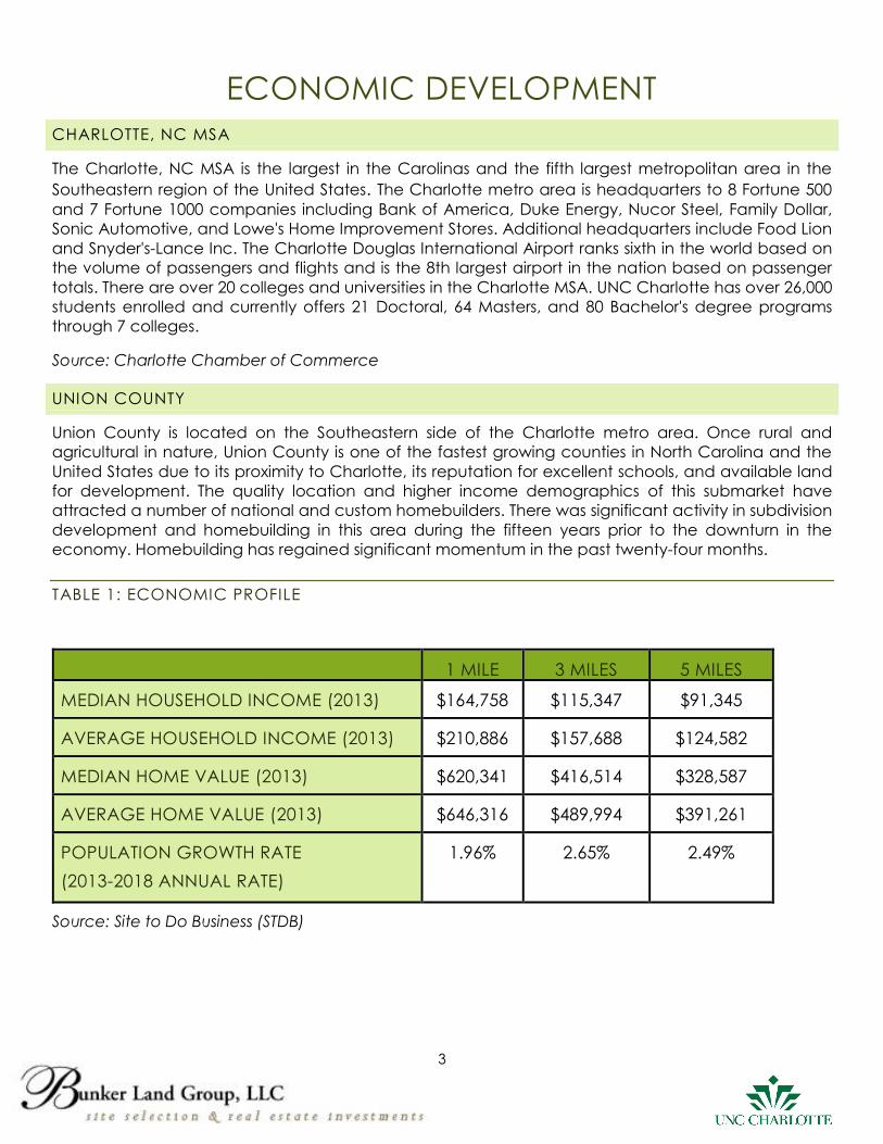
ECONOMIC DEVELOPMENT
CHARLOTTE, NC MSA
The Charlotte, NC MSA is the largest in the Carolinas and the fifth largest metropolitan area in the
Southeastern region of the United States. The Charlotte metro area is headquarters to 8 Fortune 500
and 7 Fortune 1000 companies including Bank of America, Duke Energy, Nucor Steel, Family Dollar,
Sonic Automotive, and Lowe's Home Improvement Stores. Additional headquarters include Food Lion
and Snyder's-Lance Inc. The Charlotte Douglas International Airport ranks sixth in the world based on
the volume of passengers and flights and is the 8th largest airport in the nation based on passenger
totals. There are over 20 colleges and universities in the Charlotte MSA. UNC Charlotte has over 26,000
students enrolled and currently offers 21 Doctoral, 64 Masters, and 80 Bachelor's degree programs
through 7 colleges.
Source: Charlotte Chamber of Commerce
UNION COUNTY
Union County is located on the Southeastern side of the Charlotte metro area. Once rural and
agricultural in nature, Union County is one of the fastest growing counties in North Carolina and the
United States due to its proximity to Charlotte, its reputation for excellent schools, and available land
for development. The quality location and higher income demographics of this submarket have
attracted a number of national and custom homebuilders. There was significant activity in subdivision
development and homebuilding in this area during the fifteen years prior to the downturn in the
economy. Homebuilding has regained significant momentum in the past twenty-four months.
TABLE 1: ECONOMIC PROFILE
1 MILE 3 MILES 5 MILES
MEDIAN HOUSEHOLD INCOME (2013) $164,758 $115,347 $91,345
AVERAGE HOUSEHOLD INCOME (2013) $210,886 $157,688 $124,582
MEDIAN HOME VALUE (2013) $620,341 $416,514 $328,587
AVERAGE HOME VALUE (2013) $646,316 $489,994 $391,261
POPULATION GROWTH RATE
(2013-2018 ANNUAL RATE)
1.96% 2.65% 2.49%
Source: Site to Do Business (STDB)
4
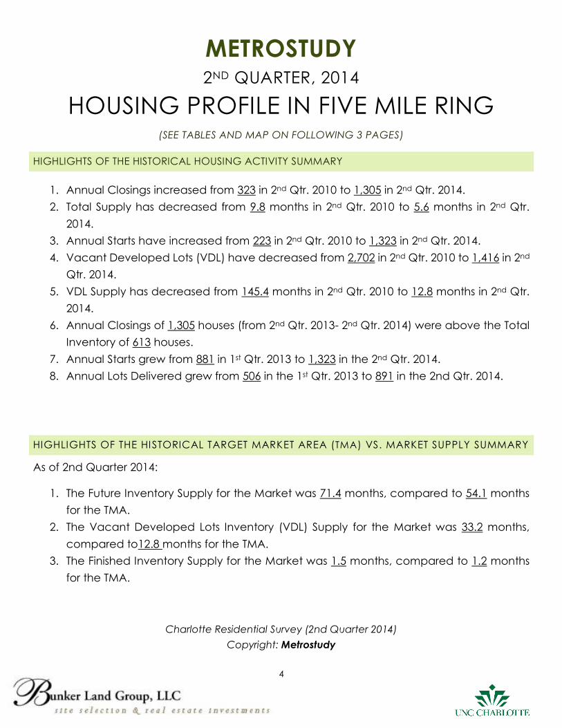
METROSTUDY
2ND QUARTER, 2014
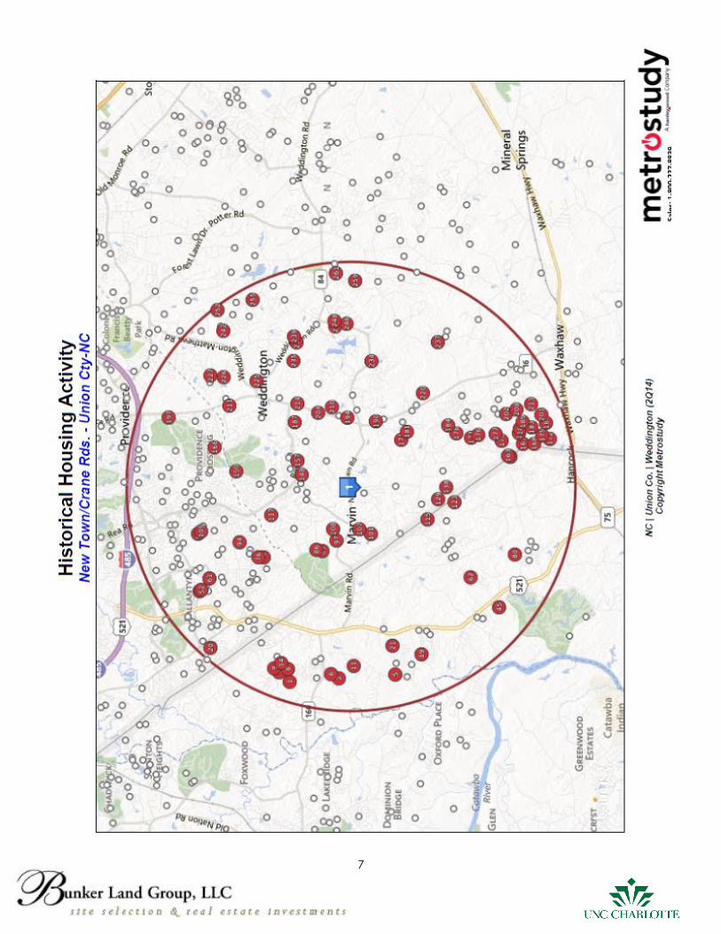
HOUSING PROFILE IN FIVE MILE RING (SEE TABLES AND MAP ON FOLLOWING 3 PAGES)
HIGHLIGHTS OF THE HISTORICAL HOUSING ACTIVITY SUMMARY
1. Annual Closings increased from 323 in 2nd Qtr. 2010 to 1,305 in 2nd Qtr. 2014.
2. Total Supply has decreased from 9.8 months in 2nd Qtr. 2010 to 5.6 months in 2nd Qtr.
2014.
3. Annual Starts have increased from 223 in 2nd Qtr. 2010 to 1,323 in 2nd Qtr. 2014.
4. Vacant Developed Lots (VDL) have decreased from 2,702 in 2nd Qtr. 2010 to 1,416 in 2nd
Qtr. 2014.
5. VDL Supply has decreased from 145.4 months in 2nd Qtr. 2010 to 12.8 months in 2nd Qtr.
2014.
6. Annual Closings of 1,305 houses (from 2nd Qtr. 2013- 2nd Qtr. 2014) were above the Total
Inventory of 613 houses.
7. Annual Starts grew from 881 in 1st Qtr. 2013 to 1,323 in the 2nd Qtr. 2014.
8. Annual Lots Delivered grew from 506 in the 1st Qtr. 2013 to 891 in the 2nd Qtr. 2014.
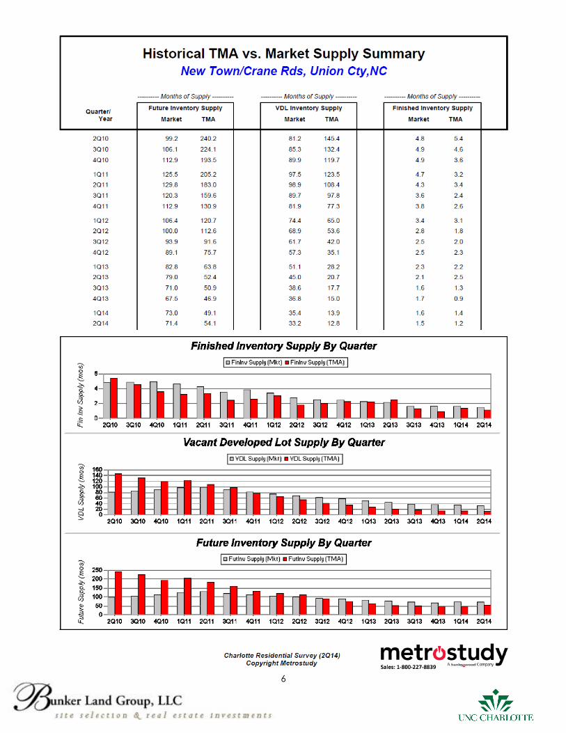
HIGHLIGHTS OF THE HISTORICAL TARGET MARKET AREA (TMA) VS. MARKET SUPPLY SUMMARY
As of 2nd Quarter 2014:
1. The Future Inventory Supply for the Market was 71.4 months, compared to 54.1 months
for the TMA.
2. The Vacant Developed Lots Inventory (VDL) Supply for the Market was 33.2 months,
compared to12.8 months for the TMA.
3. The Finished Inventory Supply for the Market was 1.5 months, compared to 1.2 months
for the TMA.
Charlotte Residential Survey (2nd Quarter 2014)
Copyright: Metrostudy
5
6
7
8
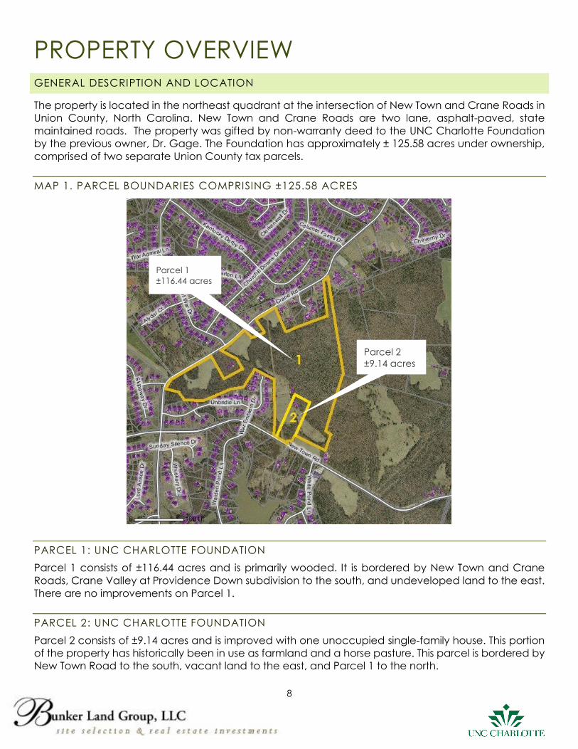
PROPERTY OVERVIEW GENERAL DESCRIPTION AND LOCATION
The property is located in the northeast quadrant at the intersection of New Town and Crane Roads in
Union County, North Carolina. New Town and Crane Roads are two lane, asphalt-paved, state
maintained roads. The property was gifted by non-warranty deed to the UNC Charlotte Foundation
by the previous owner, Dr. Gage. The Foundation has approximately ± 125.58 acres under ownership,
comprised of two separate Union County tax parcels.
MAP 1. PARCEL BOUNDARIES COMPRISING ±125.58 ACRES
PARCEL 1: UNC CHARLOTTE FOUNDATION
Parcel 1 consists of ±116.44 acres and is primarily wooded. It is bordered by New Town and Crane
Roads, Crane Valley at Providence Down subdivision to the south, and undeveloped land to the east.
There are no improvements on Parcel 1.
PARCEL 2: UNC CHARLOTTE FOUNDATION
Parcel 2 consists of ±9.14 acres and is improved with one unoccupied single-family house. This portion
of the property has historically been in use as farmland and a horse pasture. This parcel is bordered by
New Town Road to the south, vacant land to the east, and Parcel 1 to the north.
Parcel 1
±116.44 acres
Parcel 2
±9.14 acres
9
PHYSICAL CHARACTERISTICS OF THE SITE
The property is flat to gently rolling and is appropriately shaped for subdivision development with
adequate road frontage along New Town and Crane Roads. Site characteristics include an
intermittent stream and an electric distribution line, which may be mitigated by developing the
property under Union County’s cluster provisions. The blue-line creek running through the property
provides a planning opportunity for a preserved trail or community greenway corridor.
MAP 2: TOPOGRAPHY
FLOOD PLAIN
According to Federal Emergency Management Administration (FEMA) Map (Panel # 4465), the
property is neither located within a watershed, nor subject to floodplain insurance nor other floodplain
regulatory requirements.
MAP 3: FEMA MAP PANEL #4465
Site
±125.58 acres

10
UTILITIES
In order to utilize the cluster provisions in the Union County Zoning Code, the site must be serviced by
Union County water and sewer. Although Union County water and sewer can be found in subdivisions
contiguous to this property, the availability and capacity of municipal services will need to be verified.
Please see the maps below for existing water and sewer lines in proximity to the property.
MAP 4: WATER
MAP 5: SEWER
Site
±125.58 acres
Site
±125.58 acres
Union County Public Works Department
Charles P. O’Cain, P.E.
704-296-4244
11
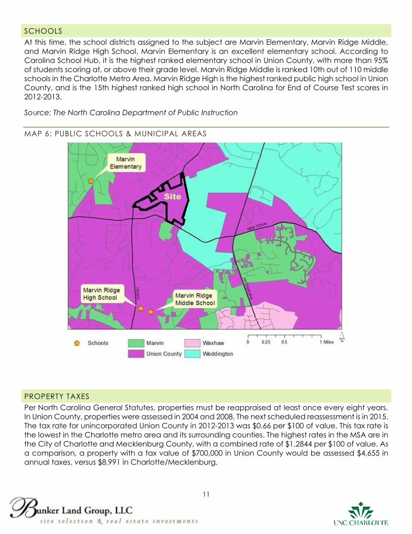
SCHOOLS
At this time, the school districts assigned to the subject are Marvin Elementary, Marvin Ridge Middle,
and Marvin Ridge High School. Marvin Elementary is an excellent elementary school. According to
Carolina School Hub, it is the highest ranked elementary school in Union County, with more than 95%
of students scoring at, or above their grade level. Marvin Ridge Middle is ranked 10th out of 110 middle
schools in the Charlotte Metro Area. Marvin Ridge High is the highest ranked public high school in Union
County, and is the 15th highest ranked high school in North Carolina for End of Course Test scores in
2012-2013.
Source: The North Carolina Department of Public Instruction
MAP 6: PUBLIC SCHOOLS & MUNICIPAL AREAS
PROPERTY TAXES
Per North Carolina General Statutes, properties must be reappraised at least once every eight years.
In Union County, properties were assessed in 2004 and 2008. The next scheduled reassessment is in 2015.
The tax rate for unincorporated Union County in 2012-2013 was $0.66 per $100 of value. This tax rate is
the lowest in the Charlotte metro area and its surrounding counties. The highest rates in the MSA are in
the City of Charlotte and Mecklenburg County, with a combined rate of $1.2844 per $100 of value. As
a comparison, a property with a tax value of $700,000 in Union County would be assessed $4,655 in
annual taxes, versus $8,991 in Charlotte/Mecklenburg.
Site
12
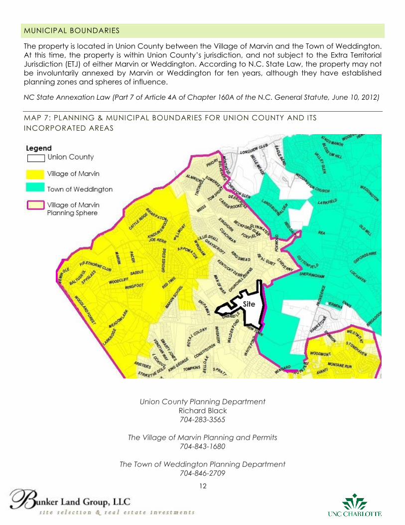
MUNICIPAL BOUNDARIES
The property is located in Union County between the Village of Marvin and the Town of Weddington.
At this time, the property is within Union County’s jurisdiction, and not subject to the Extra Territorial
Jurisdiction (ETJ) of either Marvin or Weddington. According to N.C. State Law, the property may not
be involuntarily annexed by Marvin or Weddington for ten years, although they have established
planning zones and spheres of influence.
NC State Annexation Law (Part 7 of Article 4A of Chapter 160A of the N.C. General Statute, June 10, 2012)
MAP 7: PLANNING & MUNICIPAL BOUNDARIES FOR UNION COUNTY AND ITS
INCORPORATED AREAS
Union County Planning Department
Richard Black
704-283-3565
The Village of Marvin Planning and Permits
704-843-1680
The Town of Weddington Planning Department
704-846-2709
Site
13
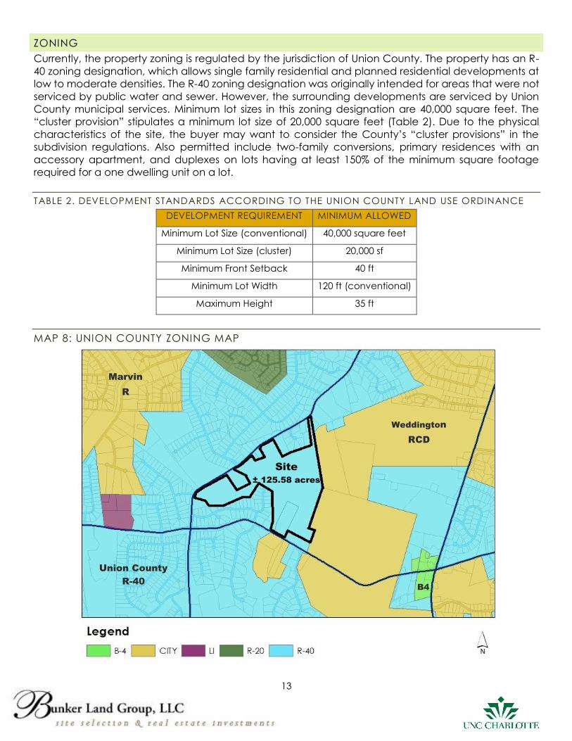
ZONING
Currently, the property zoning is regulated by the jurisdiction of Union County. The property has an R-
40 zoning designation, which allows single family residential and planned residential developments at
low to moderate densities. The R-40 zoning designation was originally intended for areas that were not
serviced by public water and sewer. However, the surrounding developments are serviced by Union
County municipal services. Minimum lot sizes in this zoning designation are 40,000 square feet. The
“cluster provision” stipulates a minimum lot size of 20,000 square feet (Table 2). Due to the physical
characteristics of the site, the buyer may want to consider the County’s “cluster provisions” in the
subdivision regulations. Also permitted include two-family conversions, primary residences with an
accessory apartment, and duplexes on lots having at least 150% of the minimum square footage
required for a one dwelling unit on a lot.
TABLE 2. DEVELOPMENT STANDARDS ACCORDING TO THE UNION COUNTY LAND USE ORDINANCE
DEVELOPMENT REQUIREMENT MINIMUM ALLOWED
Minimum Lot Size (conventional) 40,000 square feet
Minimum Lot Size (cluster) 20,000 sf
Minimum Front Setback 40 ft
Minimum Lot Width 120 ft (conventional)
Maximum Height 35 ft
MAP 8: UNION COUNTY ZONING MAP
Union County
R-40 B4
Site
± 125.58 acres
Weddington
RCD
Marvin
R
14
DISCLAIMERS:
The Sellers and Seller’s Exclusive Agents (here collectively as we, us, our, etc,) have obtained the
information continued herein from sources believed reliable. While we have no reason to doubt its
accuracy, we have not verified it and make no guarantee, warranty or representation about the
information (including without limitation, none about the information’s accuracy, completeness,
applicability, or appropriateness). It is the responsibility of all parties interested in this property (herein
as you, your, etc.) to conduct a careful, independent investigation of the property to discover, obtain
and verify all applicable information regarding and / or affecting the property (including without
limitation the information contained herein; all local, municipal, state and federal regulations; utility
improvements and services; geo technical information; hydrological information; topographical
information; environmental information; information regarding the property’s title, boundaries,
encumbrances, etc; and all other applicable information) and independently determine to your
complete satisfaction the suitability of the property for your needs. You must not base your
expectations of the property, any of your actions regarding the property, or any offer for the property
upon any information disseminated by us. Unless otherwise expressly stated in writing, the two sole
purposes of all information we disseminate regarding the property (including without limitation all
distances, boundaries, acreages, data, etc, in all text and / or shown on all aerial photos, maps, and
other illustrations, have been, are, and will be (1) to create an awareness of the property’s availability,
and (2) to share information we have obtained regarding the property merely as a courtesy, but
expressly not for the purpose of fulfilling any of your due diligence responsibilities or in any way making
any express or implied representations or warranties regarding the information.
This property is being offered on an “AS IS, WHERE IS, WITH ALL FAULTS” BASIS. THE OWNER OF THE
PROPERTY, THE OWNER’S EXCLUSIVE AGENTS, AND THEIR EMPLOYEES, AGENT, SUBSIDIARIES OR
AFFILIATES, MAKE NO WARANTY OR REPRESENTATION, EXPRESS OR IMPLIED OR ARISING BY OPERATION
OF LAW, INCLUDING WITHOUT LIMITATION ANY WARRANTY OF CONDITION, HABITABILITY,
MERCHANTABILITY OR FITNESS FOR A PARTICULAR PURPOSE, WITH RESPECT TO THE PROPERTY. Further,
we hereby expressly disclaim any warranty, guarantee or representation, express or implied, oral or
written, past, present, or future, of as to, or concerning any and all characteristics potentially or actually
concerning the property including without limitation: (a) the condition of the property or any
improvements (on site or off site) which may affect the property; (b) the extent of any right-of way,
lease, possession, lien, encumbrance, easement, license, reservation or condition with the Property;
(c) the compliance of the Property or its operation with any applicable laws, ordinances, or regulations
of any government, public, private, or other body, including without limitations, compliance with any
past, present or future land us or the Americans with Disabilities Act, wetland, zoning law or regulations,
applicable environmental or watershed or wetland laws, rules, ordinances and regulations, property
owners associations; (d) title to the property, boundaries of the property, or any easements, regulatory
rules or any encumbrances which may affect the property; (e) the property’s access, ingress or egress;
and (f) the physical condition of the property and its surroundings, including without limitation the
structural, mechanical and engineering characteristics of any improvements which may affect the
property.
15
ADDENDUM
16
CONCEPTUAL SITE PLAN
17
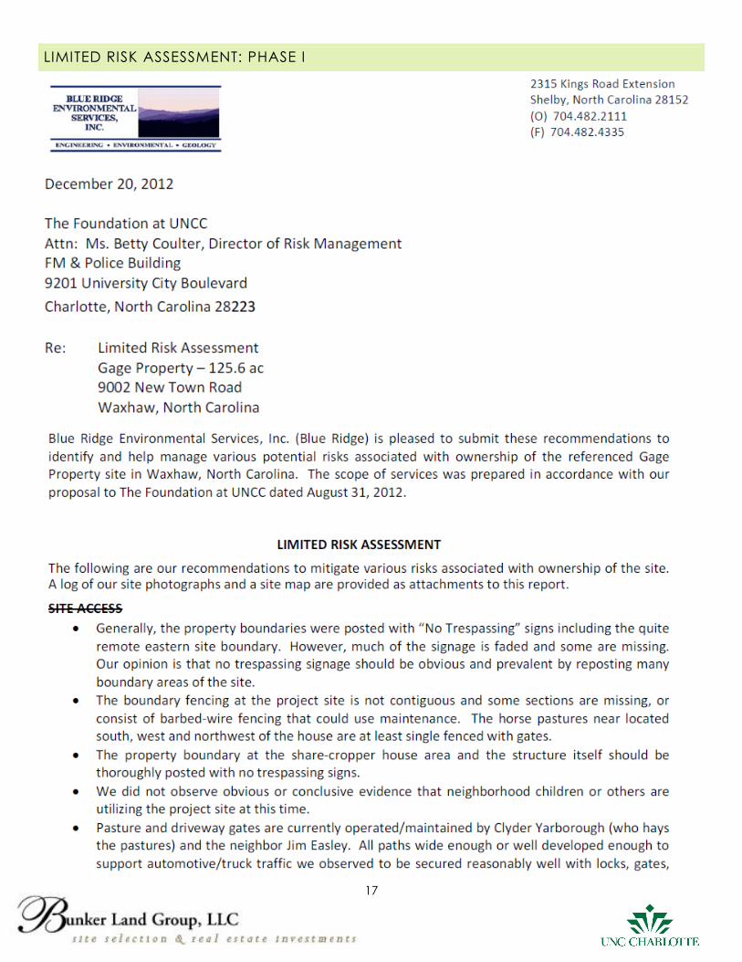
LIMITED RISK ASSESSMENT: PHASE I
18
19
20
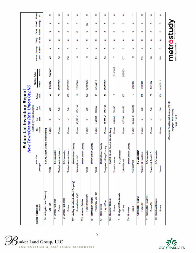
21
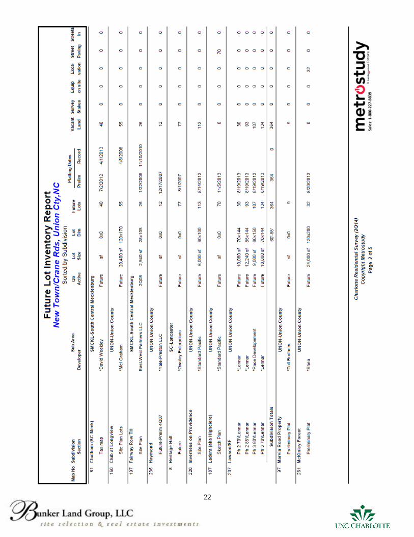
22
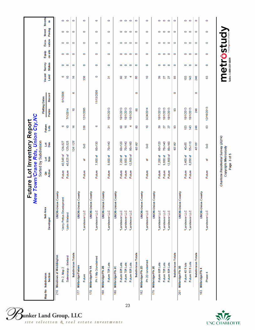
23
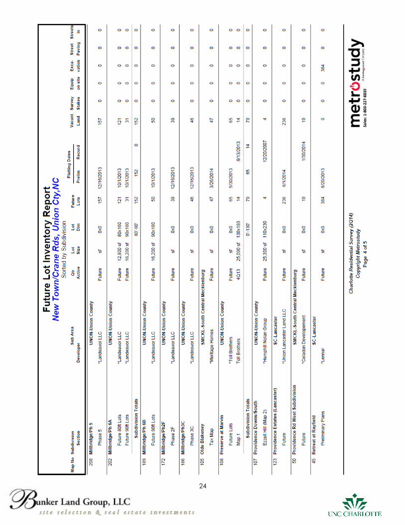
24
25
26
27
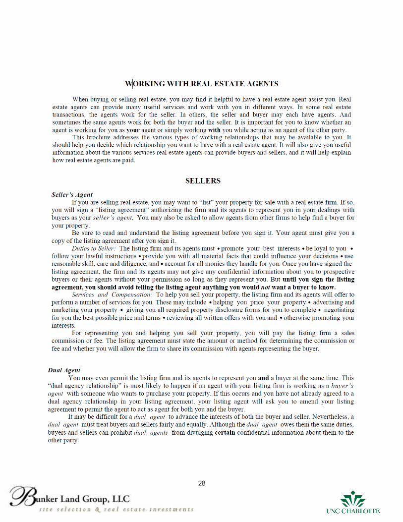
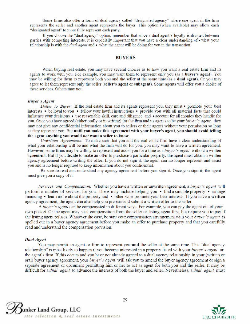
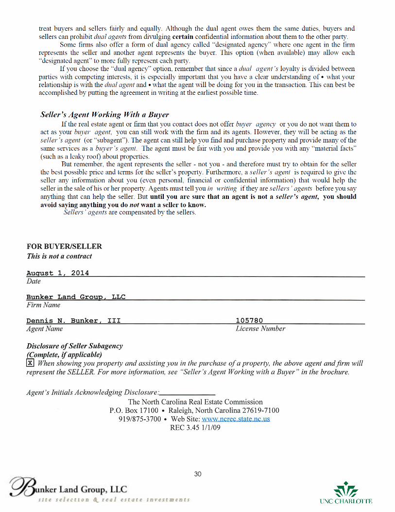
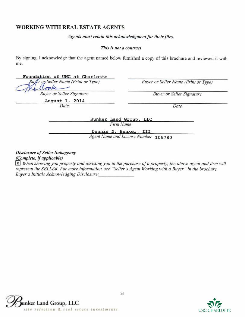
BROCHURE: WORKING WITH REAL ESTATE AGENTS
The following four pages are a reprint of a brochure provided by the North Carolina Real Estate
Commission. Please sign the last page of this brochure, as an indication that you have
received, read and understand the brochure. After signing, please mail or e-mail the signed
page to Bunker Land Group, LLC at the following address:
Bunker Land Group, LLC
Attn: Dennis N. Bunker, III
1140 Dilworth Crescent Row
Charlotte, NC 28203
28
29
30
31