u urrbbaann ffllooooddppllaaiinn...
TRANSCRIPT
UUUrrrbbbaaannn fffllloooooodddppplllaaaiiinnn mmmaaannnaaagggeeemmmeeennnttt iiinnn EEEuuurrrooopppeee aaannnddd AAAmmmeeerrriiicccaaa
RRReeelllaaattteeeddd tttooo ffflllooooooddd dddaaammmaaagggeee ppprrreeevvveeennntttiiiooonnn:::
aaa fffeeewww eeexxxaaammmpppllleeesss aaannnddd ssstttrrraaattteeegggiiieeesss cccooommmpppaaarrreeeddd
AUTHOR: KATHY BECKER-GOSS

2
3
UUUrrrbbbaaannn fffllloooooodddppplllaaaiiinnn mmmaaannnaaagggeeemmmeeennnttt iiinnn EEEuuurrrooopppeee aaannnddd AAAmmmeeerrriiicccaaa
RRReeelllaaattteeeddd tttooo ffflllooooooddd dddaaammmaaagggeee ppprrreeevvveeennntttiiiooonnn:::
aaa fffeeewww eeexxxaaammmpppllleeesss aaannnddd ssstttrrraaattteeegggiiieeesss cccooommmpppaaarrreeeddd
�The principles of floodplain management are now well known. There�s no silver bullet. What you need is people willing to come to grips with the problem honestly. And now is the time to come to grips with it, because the half-life of memories of floods is very short.�
Brig. Gen. Gerald Galloway (1994)
KATHY BECKER-GOSS February 5, 2007 Master�s Thesis Module: Second Phase Environmental Science Saxion University, Deventer, Netherlands University of Greenwich, London, England, UK Saxion University Sponsors:
Ir. Frans Bertels Ir. Harrie van Bommel
External sponsor: Drs. Piet van Iersel
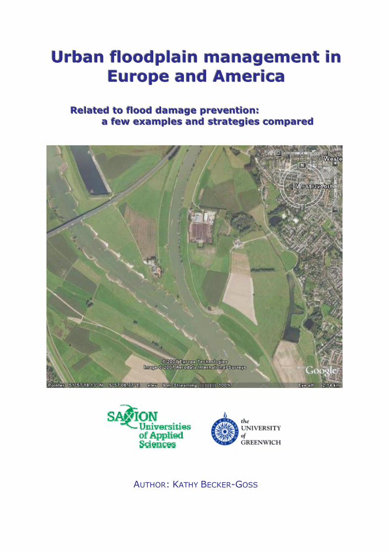
Cover photo: Westervoort, The Netherlands, split of the Rhine river into the lower Rhine and the IJssel rivers. (Google Earth 2007)
4
Preface The research project described in this paper has been completed in order to meet the requirements of the Master of Environmental Science programme (specializing in Water and Natural Resource Management) at Saxion University, Deventer, The Netherlands. The programme is accredited by Greenwich University, London. The project began on June 15, 2006 and has been completed February 5, 2007. The topic for this research project must be relevant, actual and include integral, interdisciplinary aspects. The results of the project must make a contribution to the scientific literature of the research subject in an area of the student�s interest. To meet these criteria water management, spatial planning and ecosystem management will be explored for strategies that can contribute to the prevention or reduction of the impacts caused by flooding in urban areas. The choice to study �Urban floodplain management in Europe and America� is rooted in reality. As an American who has lived in The Netherlands for the past 13 years (and studied for the past two), I find it interesting to compare the two countries and see if there are strategies or management tools that we can share with each other. Case studies have been conducted on 3 projects in The Netherlands and 2 in Houston, Texas. These projects are to serve as study material for the development of better planning strategies for floodplain management in urban areas. As such this report will be sent to the participating agencies and organisations. In the U.S. these are the U.S. Army Corps of Engineers, Galveston District and the Harris County Flood Management District in Houston Texas. In The Netherlands these are the Dutch Ministry of Transportation and Public Works (RWS) and the Water boards De Dommel, Aa and Maas, and Brabantse Delta. Many thanks must go out to the people who helped to make this project possible: my coach and �chief-difficult-question-asker�: sponsor Ir. Frans Bertels and my co-sponsor, Ir. Harrie van Bommel. Also thanks to Dr. Piet van Iersel, my external sponsor, who remained alert and interested even with long silences in between contacts. Thanks to all of the people who took the time to provide information, to answer my questions and to comment on my work: Mr. Bart Pastor, Ir. Marcel van Betuw, Mr. Henk Eerden, Mr. Gene Rushing, Mr. Raouf Farid, Dr. Brack Hale, Dr.-Ing. Manfred Ostrowski and Dr. Peter Horchler. Thanks to my study partners, Atse Veeke, Cuno Grootscholten and Frank Meijer for keeping me on schedule with regular deadlines and for providing crucial feedback. And a very special thanks to my family, Hans, Carine, Chris and Marlies for all their help. And most of all, thanks to Chris, Hans, Ellen and Sydney for all their love, help and support.
5
Table of Contents Preface.......................................................................................................4 Summary ...................................................................................................9 Chapter 1 Introduction ........................................................................11
1.1 The need for floodplain management research.......................................... 11 1.1.1 Why flood damage prevention in urban floodplains? .................................... 11 1.1.2 Factors affecting urban floodplains............................................................... 12 1.1.3 Actors affecting urban floodplains................................................................. 13 1.1.4 Strategies for managing urban floodplains................................................... 14
1.2 Thesis: main research question and research goals .................................. 15 1.2.1 General ........................................................................................................ 15 1.2.2 Main research question ................................................................................ 15 1.2.3 Research goals ............................................................................................ 16 1.2.4 Definition of terms ........................................................................................ 16
1.3 Reader�s guide ........................................................................................... 18 Chapter 2 Research methods.............................................................19
2.1 General research plan................................................................................ 19 2.2 Limiting the scope of the research: choices and assumptions.................... 19
2.2.1 Choice of strategies for water management, spatial planning and ecosystem management................................................................................................. 19
2.2.2 Relating sustainable floodplain management to ecosystem management .... 20 2.2.3 Choice of study areas................................................................................... 21
2.3 Data sources: project plans and interviews ................................................ 21 Chapter 3 Analysis framework............................................................22
3.1 Introduction................................................................................................. 22 3.2 Traditional flood control strategies: Command and control paradigm......... 22 3.3 A changing paradigm: sustainable floodplain management principles ....... 23 3.4 Challenges in the transition ........................................................................ 25 3.5 What needs to be done .............................................................................. 26 3.6 One possible strategy: ecosystem management........................................ 26 3.7 Adapting the ecosystem management framework for use in sustainable
urban floodplain management .................................................................... 27 3.8 Theory behind framework........................................................................... 27 3.9 Relationship between the framework and the main research question ...... 34
Chapter 4 Cases studied in the framework ........................................35
4.1 Case study presentation............................................................................. 35 4.1.1 Case study criteria........................................................................................ 35
4.2 Using the framework .................................................................................. 36 4.2.1 Data collection.............................................................................................. 36 4.2.2 Scoring system............................................................................................. 36
4.3 Case A: Dynamic brook valley: River Aa, The Netherlands ....................... 38 4.3.1 Dynamic brook valley project description...................................................... 38 4.3.2 Water management, spatial planning and ecosystem management factors of
the Dynamic brook valley case ..................................................................... 38
6
4.3.3 Dynamic brook valley case evaluation in the framework............................... 40 4.4 Case B: Reconstruction Tongelreep valley, The Netherlands .................... 42
4.4.1 Tongelreep valley project description ........................................................... 42 4.4.2 Water management, spatial planning and ecosystem management factors of
the Tongelreep valley case........................................................................... 44 4.4.3 Tongelreep Valley case evaluation in the framework.................................... 44
4.5 Case C: Hondsbroeksche Pleij, The Netherlands ...................................... 46 4.5.1 Hondsbroeksche Pleij project description ..................................................... 46 4.5.2 Water management, spatial planning and ecosystem management factors of
the Hondsbroeksche Pleij case.................................................................... 46 4.5.3 Hondsbroeksche Pleij case evaluation in the framework .............................. 47
4.6 Case D: Sims Bayou, Texas....................................................................... 50 4.6.1 Sims Bayou project description ................................................................... 50 4.6.2 Water management, spatial planning and ecosystem management factors of
the Sims Bayou case .................................................................................... 50 4.6.3 Sims Bayou case evaluation in the framework ............................................. 52
4.7 Case E: Brays Bayou, Texas..................................................................... 55 4.7.1 Brays Bayou project description .................................................................. 55 4.7.2 Water management, spatial planning and ecosystem management factors of
the Brays Bayou case................................................................................... 57 4.7.3 Brays Bayou case evaluation in the framework ............................................ 58
4.8 Case study scores in the framework .......................................................... 58 Chapter 5 Analysis and presentation of results..................................60
5.1 Methods ..................................................................................................... 60 5.2 Analysis of framework scores..................................................................... 60
5.2.1 Total score within framework........................................................................ 60 5.2.2 Comparison of the Dutch cases with the Houston cases .............................. 61 5.2.3 Score per ecosystem management theme ................................................... 61 5.2.4 Score per ecosystem management attribute ................................................ 62
Chapter 6 Discussion of results and methods....................................65
6.1 Discussion of the case study results .......................................................... 65 6.1.1 Total score within framework........................................................................ 65 6.1.2 Comparison of the Dutch cases with the Houston cases .............................. 65 6.1.3 Score per ecosystem management theme ................................................... 65 6.1.4 Score per ecosystem management attribute ................................................ 66
6.2 Discussion of the framework ...................................................................... 66 6.2.1 Overall use of the framework........................................................................ 66 6.2.2 Usefulness in project plans and evaluations................................................. 68
6.3 What did the experts say about the framework? ........................................ 68 Chapter 7 Conclusions and recommendations ..................................69
7.1 Conclusions of the case study research..................................................... 69 7.2 Conclusions of the methods and framework............................................... 69 7.3 Answering the main research question ...................................................... 70 7.4 Recommendations for further research with the framework ....................... 70 7.5 Recommendations for urban floodplain managers..................................... 71 7.6 The last word.............................................................................................. 72
Literature..................................................................................................73
7
Appendix 1 Research questions..............................................................78 Appendix 2 Abbreviations........................................................................81 Appendix 3 Research process flow chart ................................................82 Appendix 4 External contacts/organisations ...........................................83 Appendix 5 Ecosystem management framework....................................84 Appendix 6 Data collection tables ...........................................................87 Appendix 7 Interview transcripts ...........................................................109 Appendix 8 Email communication .........................................................123 Appendix 9 Data analysis tables ...........................................................125

8
9
Summary This report is the final product of a research project completed to meet the requirements of a Master of Environmental Science Degree (from Greenwich University, London) completed at Saxion University, Deventer, The Netherlands. During the study of Dutch and European water and natural resource management these past two years, it has become clear that there are big differences between strategies used in floodplain management in the United States and The Netherlands. This paper attempts to measure some of these differences and to see what we can learn on both sides of the ocean. After the review of much literature concerning floodplain management the choice was made to use and adapt an existing framework to evaluate strategies used in flood control projects. This ecosystem management framework was adapted to study the use (or absence) of sustainable floodplain management principles in project planning. With this method two things would be accomplished. First, a study would be made of several cases from the U.S. and The Netherlands, and differences in strategies used and management goals could be identified. Secondly, the framework would be tested for its usefulness in such evaluations. Five cases studies were conducted of urban floodplain management projects for the prevention of damage due to flooding that are in the planning or implementation phases. Three cases in The Netherlands and two from the U.S. city of Houston, in the state of Texas, were compared. The most important conclusions are listed below. The Dutch cases use a significantly higher percentage of sustainable floodplain management strategies than the Houston cases both on an individual and on an average basis. Houston water managers can learn much from the Dutch about the use of a systems approach when planning flood control projects and striving for long term sustainability in projects. Systems approach strategies include: goals for sustainability, the use of resilience strategies, the use of the �retain, store and then drain� principle and the integration of stormwater and groundwater with surface water management in planning flood control projects. Comparison between the two Houston cases showed that the newer Brays Bayou case (2000) planning strategies (led by Harris County Flood Control District) represented significant improvements in the use of sustainable floodplain management strategies compared to the planning of the Sims Bayou case which was led by the U.S. Army Corps of Engineers (1982). And that the policies to gain ownership of flood prone lands and the uncertainty of sufficient funding are seen as weaknesses in both the Houston cases. These weaknesses are related to the organisational structure of the Houston cases. All cases could improve the use of strategies using ecosystem goods and services in planning or as compensation for land use change and could improve the use of public education in planning strategies. In view of the above results, the adapted framework was seen as providing a valid structure to examine weaknesses in the planning of flood control projects with respect to the use of sustainable floodplain management strategies within an ecosystem management framework. The most important recommendations are listed below.
10
Dutch and Houston water managers should be encouraged to continue on their course of implementing sustainable floodplain management strategies. And should continue in their search for workable solutions to using the value of ecosystem services (green and blue services in Dutch) to compensate and pay for projects. The Harris County Flood Control District and the U.S. Army Corps of Engineers at the Galveston District should immediately explore the use of the systems approach as it can provide valuable additions to the current strategies for both Sims and Brays Bayous. This should be seen in the context of events like Tropical Storm Allison: broaden the meaning of sustainability in planning to add resilience to the system so that it can deal with such events. Another valuable addition would be investigating the value of urban stormwater strategies, such as the use of green roofs, or local infiltration systems such as are now used at the Texas Medical Center. Do not exclude the improvement of ecological integrity (such as water quality and the use of sponge capacity in soil) of the Bayous. Subsidence is a costly problem in Texas and the water quality running off the Bayous is directly affecting the water quality of Galveston Bay and ultimately the Gulf of Mexico. Explore the possibility of a monetary value given to the services the Bayous provide. In the light of the difficulties already experienced in public opposition to far reaching, long term plans: educate the public that the need of solving this problem long term has a price, but the price is worth paying. And last but not least, entertain the idea that approaching such issues from a less economic perspective (benefit/cost at all costs) by using the ecosystem management method with the urban area as part of the ecosystem can open up options. Key words: floodplain, floodplain management, sustainable floodplain management, flood damage prevention, water management, spatial planning, ecosystem management, analysis framework Trefwoorden: watermanagement, ruimtelijke ordening, duurzaam waterbeheer, ecosysteem management, analyse kader, overstromingsschade voorkomen
11
Chapter 1 Introduction
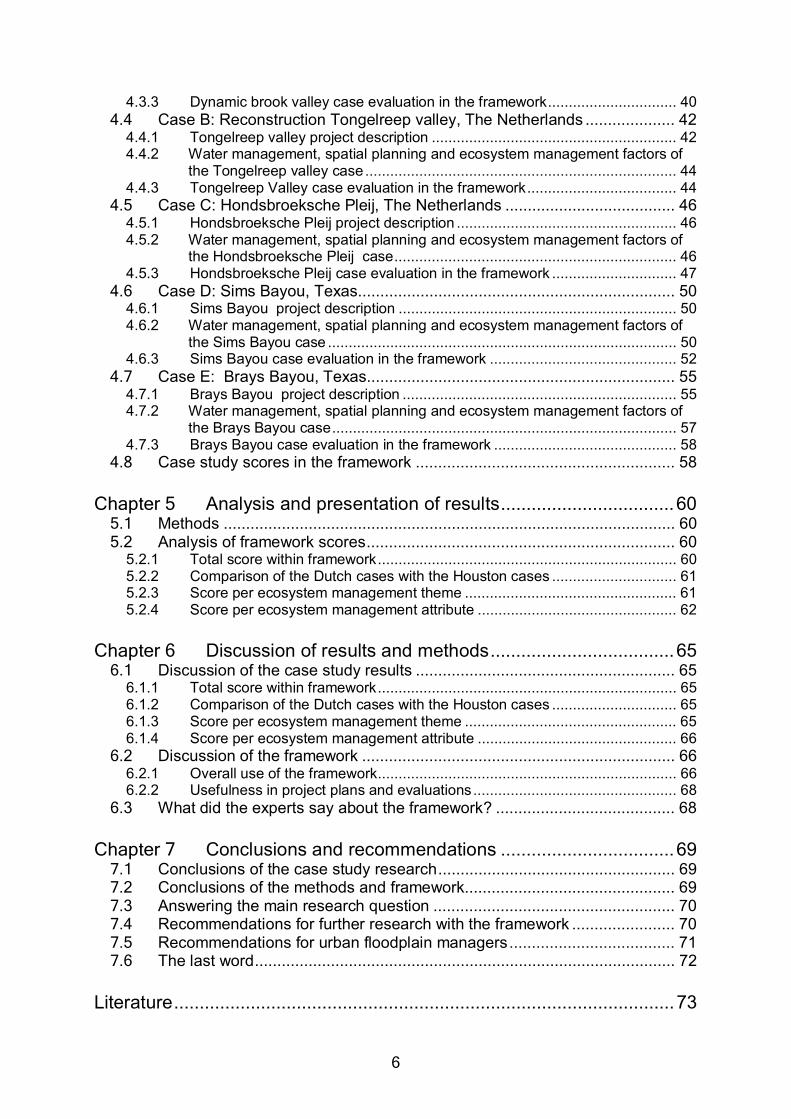
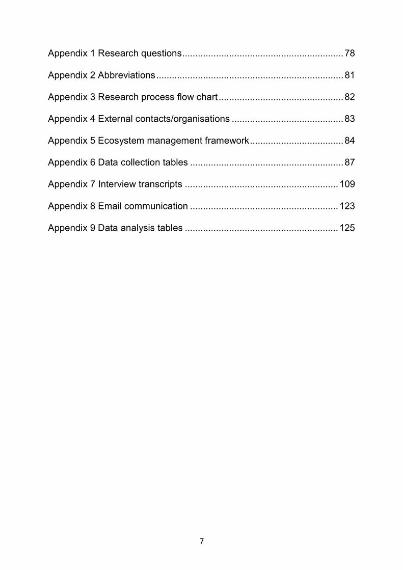
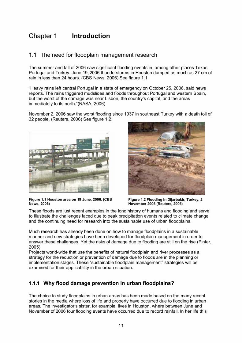
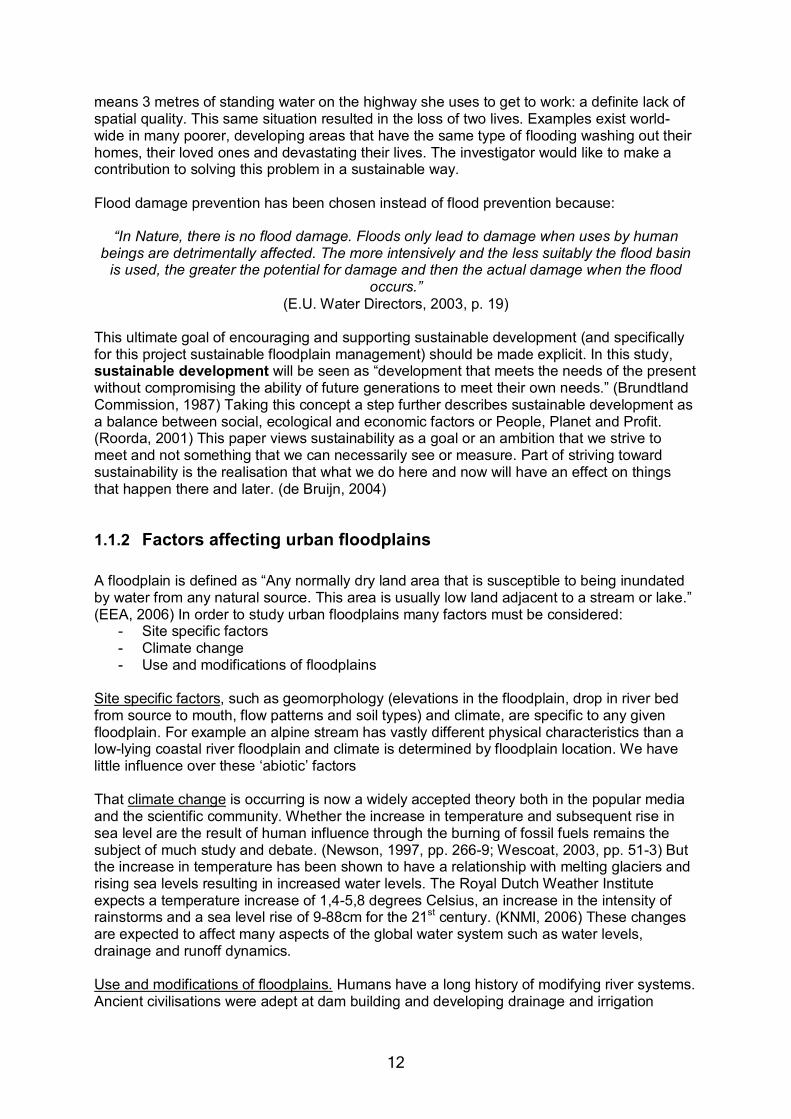
1.1 The need for floodplain management research The summer and fall of 2006 saw significant flooding events in, among other places Texas, Portugal and Turkey. June 19,,2006 thunderstorms in Houston dumped as much as 27 cm of rain in less than 24 hours. (CBS News, 2006) See figure 1.1. �Heavy rains left central Portugal in a state of emergency on October 25, 2006, said news reports. The rains triggered mudslides and floods throughout Portugal and western Spain, but the worst of the damage was near Lisbon, the country�s capital, and the areas immediately to its north.�(NASA, 2006) November 2, 2006 saw the worst flooding since 1937 in southeast Turkey with a death toll of 32 people. (Reuters, 2006) See figure 1.2.
Figure 1.1 Houston area on 19 June, 2006. (CBS News, 2006)
Figure 1.2 Flooding in Dijarbakir, Turkey, 2 November 2006 (Reuters, 2006)
These floods are just recent examples in the long history of humans and flooding and serve to illustrate the challenges faced due to peak precipitation events related to climate change and the continuing need for research into the sustainable use of urban floodplains. Much research has already been done on how to manage floodplains in a sustainable manner and new strategies have been developed for floodplain management in order to answer these challenges. Yet the risks of damage due to flooding are still on the rise (Pinter, 2005). Projects world-wide that use the benefits of natural floodplain and river processes as a strategy for the reduction or prevention of damage due to floods are in the planning or implementation stages. These �sustainable floodplain management� strategies will be examined for their applicability in the urban situation.
1.1.1 Why flood damage prevention in urban floodplains? The choice to study floodplains in urban areas has been made based on the many recent stories in the media where loss of life and property have occurred due to flooding in urban areas. The investigator�s sister, for example, lives in Houston, where between June and November of 2006 four flooding events have occurred due to record rainfall. In her life this
12
means 3 metres of standing water on the highway she uses to get to work: a definite lack of spatial quality. This same situation resulted in the loss of two lives. Examples exist world-wide in many poorer, developing areas that have the same type of flooding washing out their homes, their loved ones and devastating their lives. The investigator would like to make a contribution to solving this problem in a sustainable way. Flood damage prevention has been chosen instead of flood prevention because:
�In Nature, there is no flood damage. Floods only lead to damage when uses by human
beings are detrimentally affected. The more intensively and the less suitably the flood basin is used, the greater the potential for damage and then the actual damage when the flood
occurs.� (E.U. Water Directors, 2003, p. 19)
This ultimate goal of encouraging and supporting sustainable development (and specifically for this project sustainable floodplain management) should be made explicit. In this study, sustainable development will be seen as �development that meets the needs of the present without compromising the ability of future generations to meet their own needs.� (Brundtland Commission, 1987) Taking this concept a step further describes sustainable development as a balance between social, ecological and economic factors or People, Planet and Profit. (Roorda, 2001) This paper views sustainability as a goal or an ambition that we strive to meet and not something that we can necessarily see or measure. Part of striving toward sustainability is the realisation that what we do here and now will have an effect on things that happen there and later. (de Bruijn, 2004)
1.1.2 Factors affecting urban floodplains A floodplain is defined as �Any normally dry land area that is susceptible to being inundated by water from any natural source. This area is usually low land adjacent to a stream or lake.� (EEA, 2006) In order to study urban floodplains many factors must be considered:
- Site specific factors - Climate change - Use and modifications of floodplains
Site specific factors, such as geomorphology (elevations in the floodplain, drop in river bed from source to mouth, flow patterns and soil types) and climate, are specific to any given floodplain. For example an alpine stream has vastly different physical characteristics than a low-lying coastal river floodplain and climate is determined by floodplain location. We have little influence over these �abiotic� factors That climate change is occurring is now a widely accepted theory both in the popular media and the scientific community. Whether the increase in temperature and subsequent rise in sea level are the result of human influence through the burning of fossil fuels remains the subject of much study and debate. (Newson, 1997, pp. 266-9; Wescoat, 2003, pp. 51-3) But the increase in temperature has been shown to have a relationship with melting glaciers and rising sea levels resulting in increased water levels. The Royal Dutch Weather Institute expects a temperature increase of 1,4-5,8 degrees Celsius, an increase in the intensity of rainstorms and a sea level rise of 9-88cm for the 21st century. (KNMI, 2006) These changes are expected to affect many aspects of the global water system such as water levels, drainage and runoff dynamics. Use and modifications of floodplains. Humans have a long history of modifying river systems. Ancient civilisations were adept at dam building and developing drainage and irrigation
13
systems. Modification within the floodplain can vary from structures such as levees and dikes that serve to �train� the river to follow a set course, to structures such as houses and businesses built on the floodplain itself. The modification of one part of the floodplain can have consequences both up and down stream from the modification. These can range from increased flow velocity to increased flood depth to slower drainage. (Newson, 1997, pp. 3-7; Wescoat, 2003, p. 8-10) A factor related to the use of floodplains is urbanisation. Urbanisation is the process of urban development whereby new structures and infrastructure lead to an increase in impermeable surfaces where precipitation and snow melt cannot penetrate into the water table and therefore cause increased runoff and therefore increased flooding. Khan proved that runoff in the Houston area has increased due to urbanisation. (Khan, 2005) This increased runoff combined with the expected increase in precipitation and water levels due to climate change will be crucial factors in the future management of modern urban floodplains.
1.1.3 Actors affecting urban floodplains This study will be limited to cases in the U.S. and in The Netherlands. Therefore a short introduction to the actors involved in these urban floodplains will be illustrative. In chapter 3 there will be a review of policies. United States In the U.S. system a national agency, the U.S. Army Corps of Engineers (USACE) is responsible for navigation and flood control when it is mandated by U.S. law. The state level (such as Texas) is responsible for water supply. The regional agency is a water board and is responsible for flood control and maintaining waterways. And the city is responsible for building and maintaining storm sewers. The state and city are not involved in flood control projects. Funds for flood control projects come from the U.S. national government (also known as the federal government) only when the projects have been included in a law passed by the U.S. House of Representatives (Congress). These laws include projects such as are found to be necessary after a major flood or disaster. Funding for these projects has to be budgeted each year, also by Congress. This can mean that some years there are more funds available than other years which can have an affect on the implementation of a project. (Pers. comm. Rushing, 2006; Farid, 2007) A relevant note to this is that the USACE falls under the Department of Defence and must compete with other defence agencies for funding such as the military operations currently going on in Iraq or Afghanistan. Another characteristic of U.S. funded projects is �that all alternative plans considered by USACE must be based on criteria used to develop a plan which achieves the objectives of National Economic Development (NED).� (USACE, 1982, p. 32) The process requires that impacts for proposed actions are measured and results displayed or accounted for in terms of contributions to NED, Environmental Quality, Regional economic development and other social effects. ( USACE, 1982, p. 29) At the regional, water board level funding can differ by state. For example, in Florida, water boards are supported directly by tax income. In Texas, funds are raised by �bonds� which is a sort of referendum that taxpayers vote for or against. This means that projects on a bond that taxpayers disagree with will have little chance of getting funded. As such, the taxpayer has a powerful influence over the water board and its projects. In cases where U.S. funding is warranted there is usually a shared cost agreement with a local sponsor such as the water board.
14
Other actors in American floodplains are homeowners, businesses, industry and nature organisations among many others. The Netherlands In The Netherlands the Dutch Department of Transportation and Public Works (RWS) is responsible for navigation and safety (flood control) of national strategic importance which includes the country�s dikes along the major rivers and the coast. The provinces are responsible for strategic water management (including water quality issues like ground and drink water and water quantity) at the regional level and form the link between national policy and the water boards. The water boards are responsible for maintenance of dikes and water levels in the many �polders� of reclaimed land as well as the implementation of projects approved of by the provinces. Water boards are also responsible for waste water treatment while municipalities are responsible for sewers and stormwater transport. Funds for national projects comes from the Second Chamber of the national government. The water boards collect their own taxes for funding. Many subsidies are available within the European Union setting. Also here, homeowners, businesses, industry, nature organisations, among many others, influence floodplain management.
1.1.4 Strategies for managing urban floodplains For this study floodplain management will be seen as:
�[t]he operation of an overall program of corrective and preventive measures for reducing flood damage, including but not limited to�plans, flood control works, and floodplain management regulations.� (Internet, DNR, 2006)
This management of floodplains requires strategies. Strategies that will be explored in this study for managing urban floodplains will be divided into the following 3 categories:
- water management - spatial planning - ecosystem management
These categories are meant to give a clear delineation within the study (especially in the descriptions of case studies in Chapter 4) of what is being studied and what isn�t. The three categories are briefly described below. Water management Water management in this study will refer to the strategies used for managing waterways (limited here to rivers and streams and excluding coastal areas) in order to meet water quantity (flood control, water supply, navigation) and water quality (human use, ecological goals) needs. This study will focus on measures, such as the placement or removal of dikes and levees, the restoration of streams and the creation of by-passes for the prevention of flood damage. Also, in the urban environment it is expected that measures such as infiltration techniques like permeable concrete or disconnecting rainwater systems from sewer systems can be valuable. Measures such as flood insurance and emergency warning systems will be omitted.
15
Spatial planning The relationship between water management and spatial planning is obvious in the definition of floodplain management above. If we didn�t build, work and live in floodplains, there would be very little risk associated with flooding. Pinter (2005) illustrates that the pressure for growth and economic development of urban floodplains, even those with a recent history of severe flooding, is still very great. For this reason spatial planning strategies, such as zoning regulations and the integration of water management in spatial plans, will be considered essential for floodplain management improvements in urban areas. Ecosystem management If the definition of an ecosystem is :
�a community of animals and plants interacting with one another and with their physical environment. Ecosystems include physical and chemical components, such as soils, water, and nutrients that support the organisms living within them. These organisms may range from large animals and plants to microscopic bacteria. Ecosystems include the interactions among all organisms in a given habitat. People are part of ecosystems. The health and wellbeing of human populations depends upon the services provided by ecosystems and their components - organisms, soil, water, and nutrients.� (ESA, 2000)
then ecosystem management themes can add valuable attributes to floodplain management as defined above. These ecosystem management themes, such as protecting natural resources so that they continue providing services add a dimension of sustainability to floodplain management projects.
1.2 Thesis: main research question and research goals
1.2.1 General Flood risks are �defined as the probability [or chance] of a flood multiplied by the damage�. (Vis et al, 2003) This has been the traditional basis for flood reduction measures. Measures such as dikes or levees, reservoirs and river training have been designed to reduce the risk of flooding by lowering the frequency of flooding. These are also referred to as �resistance strategies� of flood control. (Vis et al, 2003) Since these resistance strategies not only tend to increase the potential flood depths, but also the potential damage, other options will be considered. (White, 2000; Vis et al, 2003; Wescoat, 2003, p. 152) The other option to reduce risk is to reduce the damage caused by flooding. �In this approach flooding is allowed in certain areas, while at the same time the adverse impact of flooding is minimised by adapting land use.� (Vis et al, 2003) These �resilience� strategies will be considered important elements in sustainable floodplain management. Flooding in itself will not be considered a problem. Reducing the risk by reducing the damage caused by flooding will be the focus.
1.2.2 Main research question After reviewing floodplain management policy and literature, and hearing of urban floods occurring recently, one is left with the question: what needs to be done to make the implementation of sustainable floodplain management work in urban situations? In many cases the policies are in place. Perhaps it�s time to look at specific flood control projects and
16
find out what is actually happening. Are planners only paying lip service to sustainable floodplain management practices and really implementing the old paradigm? Or are other factors overriding the planners, such as the desire for economic growth and development? Or are politics preventing the integration of watershed managers with urban drainage managers? Are there strategies being used in one place that might work in another? In order to address these issues the following main research question has been formulated:
Which floodplain management strategies should be used in urban areas to prevent damage due to flooding while also improving the sustainable use of floodplains?
A framework for the analysis of sustainable floodplain management will be developed in order to answer this question. This framework will include concepts from theory as well as practical experiences from water managers. A complete list of research questions designed to answer the main research question is found in Appendix 1.
1.2.3 Research goals The goal of this research project is the sustainable improvement in the environmental and spatial quality of flood-prone urban areas by making a contribution to the practice of sustainable floodplain management. To reach this goal floodplain management strategies will be researched for a more effective management of floodplains that will result in less damage due to flooding in urban areas. Results in the form of recommendations will be aimed toward water and floodplain managers throughout the United States and the European Union, but specifically for the water management authorities involved in the areas of study: Harris County Flood Management District in Houston, Texas, the U.S. Army Corps of Engineers at the Galveston district, the Netherlands Department of Transportation and Public Works and the Dutch Water Boards Aa and Maas and De Dommel . A secondary goal of the study is the development of an analysis framework that can be used for the evaluation of flood control projects and by extension for the improvement of planning strategies for such projects in other areas.
1.2.4 Definition of terms Which � strategies refers to the expected results of the study that will come in the form of recommendations for possible changes in policy, legislation, planning processes, measures, etc. These will be derived through the analysis of a number of flood control project plans using a framework for the sustainable use of floodplains developed within this study. sustainable floodplain management strategies This includes the concepts discussed in this paper such as the use of water management, spatial planning and ecosystem management strategies in order to maintain high water quality and quantity conditions, fulfil present and future water demands, minimize potential environmental impacts and to increase the resilience of the floodplain. Water management, spatial planning and ecosystem management policies, plans, instruments and measures must take the interdependency of human and natural factors into account. (Zacharias et al, 2003) floodplain is defined as �Any normally dry land area that is susceptible to being inundated by water from any natural source. This area is usually low land adjacent to a stream or lake.� (EEA, 2006)
17
floodplain management is defined as �The operation of an overall program of corrective and preventive measures for reducing flood damage, including but not limited to� plans, flood control works, and floodplain management regulations.� (Internet, DNR, 2006) This management of floodplains requires strategies. Strategies that will be explored in this study for managing urban floodplains will be divided into the following 3 categories:
- water management - spatial planning - ecosystem management
These categories are meant to give a clear delineation within the study (especially in the descriptions of case studies in Chapter 4) of what is being studied and what isn�t. The three categories are briefly described below. Water management in this study will refer to the strategies used for managing waterways (limited here to rivers and streams and excluding coastal areas) in order to meet water quantity (flood control, water supply, navigation) and water quality (human use, ecological goals) needs. This study will focus on measures, such as the placement or removal of dikes and levees, and the restoration of streams, for the prevention of flood damage. Some (non-structural) measures such as flood insurance and emergency warning systems will be omitted. The relationship between water management and spatial planning is obvious in the definition of floodplain management above. If we didn�t build, work and live in floodplains, there would be very little risk associated with flooding. Pinter illustrates that the pressure for growth and economic development of urban floodplains, even those with a recent history of severe flooding, is still very great. (Pinter, 2005) For this reason spatial planning strategies, such as zoning regulations and the integration of water management in spatial plans, will be considered essential for floodplain management improvements in urban areas. If the definition of an ecosystem is: �a community of animals and plants interacting with one another and with their physical environment. Ecosystems include physical and chemical components, such as soils, water, and nutrients that support the organisms living within them. These organisms may range from large animals and plants to microscopic bacteria. Ecosystems include the interactions among all organisms in a given habitat. People are part of ecosystems. The health and wellbeing of human populations depends upon the services provided by ecosystems and their components - organisms, soil, water, and nutrients.� (ESA, 2000) then ecosystem management themes can add valuable attributes to floodplain management as defined above. These ecosystem management themes, such as protecting natural resources so that they continue providing services add a dimension of sustainability to floodplain management projects. urban areas for this study will be considered areas affected by the following factors:
- Risk of flood: o the risk is great due the proximity of human activity and value of structures
within the floodplain. - Growing population:
o the area�s population is growing fast and is expected to continue growing. - Increasing investment:
o investments, including infrastructure within the floodplain, is intensive and expected to increase. This means damage is very costly if floods occur.
- Climate change: o the threat of climate change combined with the increase in impermeable
surface area is expected to increase runoff in the future. (Alberts, 2006; Oosterberg and van Drimmelen, 2006)
18
prevent damage due to flooding In this study the prevention of damage due to flooding will be considered a reduction in the frequency and severity of damage due to flooding. Flooding in itself will not be considered a problem. Loss of life and property as well as long term effects of flooding such as replacement of infrastructure (cost) and loss of economic activity will be considered damage. improving the sustainable use of floodplains refers to the theory that by balancing social, ecological and economic aspects of development will lead to a more sustainable use of natural resources. This theory focuses on long term solutions while recognizing the limitations of using the knowledge available at the present time.
1.3 Reader�s guide The rest of this paper will describe the steps taken to find an answer to the main research question. Chapter 2 briefly describes the methods used to complete the research. Chapter 3 gives descriptions of the strategies currently used in floodplain management and explores a new possible strategy: ecosystem management. Chapter 3 concludes with the development of an analysis framework for evaluating urban flood control projects. Chapter 4 describes the application of this framework in five case studies. Chapter 5 analyses and presents the results of this evaluation. Chapter 6 discusses the results of the case studies as well as the use of the framework. Chapter 7 will present the conclusions of the project with an answer to the main research question and possible recommendations to water managers and researchers. Following chapter 7 is an extensive list of the literature used in the project which is then followed by several appendices filled with relevant data. A few additional notes to the reader: - Appendix 2 has a list of abbreviations used in the paper. - When describing the governmental structure in the United States the U.S. national
government will be referred to as the national or U.S. government; (these terms are interchangeable in the U.S. with federal government). If a state is referred to it is state government such as the State of Texas.
- When describing European Community and European Commission laws and policies E.U. will be used. This is an oversimplification of the reality of the European Community and European Commission as law making entities and the European Union as a political entity.
- There may be discrepancies in spelling caused by writing this paper in British English and quoting sources or describing situations in American English. For example the British English spelling �programme� is used in the investigator�s own text, but is spelled program when referring to U.S. policies.
19
Chapter 2 Research methods This chapter describes the general research plan, the limits of the research and the data sources used in the study.
2.1 General research plan Below, divided into 5 overlapping phases , is a generalised list of the steps taken to complete the study. Appendix 3 contains a research process flow chart that describes the project as it was planned. Orientation/exploration In this phase the research design was developed after searching through the available literature databases which provided information about research methods, design and possible analysis frameworks. Parallel to the search for methods was the search for valid research topics which resulted in the choice to study sustainable strategies for urban floodplain management. The completion of this phase was marked with an approved research plan. Exploration/inventory In this phase the so called �Body of knowledge� was explored for theories behind sustainable floodplain management principles which provide the theoretical basis for the concepts in this report. This inventory of knowledge was then organised into categories for use in the evaluation and analysis of data. Evaluation/Analysis In this phase an analysis framework was found, adapted and used in the study. These developments are described in detail in chapter 3. Several case studies (using planning documents and interviews) were evaluated within the framework. They are described in detail in chapter 4. The results of these evaluations were used for discussions and conclusions about the project plans analysed and about the use of the framework in improving floodplain management in urban areas. Results are presented in chapter 4 and 5 and discussions and conclusions in chapters 6 and 7 respectively.
2.2 Limiting the scope of the research: choices and assumptions Obviously many choices had to be made to narrow the scope of the project. These limitations are necessary due to restrictions in time (6 months), money (only personal financing) and language (information must be in Dutch or English). Choices made in limiting the project are described below.
2.2.1 Choice of strategies for water management, spatial planning and ecosystem management
Choosing to study aspects of water management and spatial plans assumes that they will have the most influence on urban floodplains and that the addition of ecosystem management aspects is essential to the increased sustainability of the projects. See 2.2.2.
20
Concentrating on the issues of water management, spatial planning and ecosystem management an evaluation is made of project planning documents and the experiences of project managers. It is assumed that planning documents are based on the policy and legislation of the national, regional and local authorities (briefly reviewed in Chapter 3) and that these three main issues will be measurable for their presence or absence in the project planning documents. This means that for example social and economic factors will not be explicitly studied. They are however indirectly represented within the other themes. Also, the detailed evaluation of policy documents, legal documents, and other literature would be too time consuming to include in this study.
2.2.2 Relating sustainable floodplain management to ecosystem management
After an intensive review of literature including the following topics about floodplain management: - risk management (Burby et al, 1999) - river basin management theory and
policy (ASFPM, 2004; CW21, 2000; E.U. 2000, 2003, 2006)
- floodplain management (Larson and Plasencia, 2001)
- ecosystem services or socio-economic benefits of floodplains (Newson, 1997; Naiman et al, 1995)
- ecosystem management (Grumbine, 1994, 1997; Hale and Adams, 2006; Marchand and Toornstra, 1986)
- integration of water management and spatial planning (Wolsink, 2006; Brouwer and van Ek, 2004, Newson, 1997)
- strategies for sustainable floodplain management (Galloway, 1994; E.U. Water directors, 2003; Newson, 1997)
the choice was made to use a broad framework of ecosystem management themes as the basis for the evaluation of projects involving floodplain management. The 10 themes are listed in table 2.1.
Ecosystem management theme 1. Systems approach 2. Ecological Boundaries 3. Ecological integrity 4. Research 5. Monitoring 6. Adaptive management 7. External Cooperation 8. Organisational structure 9. Humans as part of nature 10. Education Outreach
Table 2.1 Ecosystem management themes from Grumbine (1997) as adapted by Hale and Adams (2006)
This approach has been chosen because all of the above listed literature topics are covered within the framework and can be related to water management, spatial planning and ecosystem management aspects. Although the framework was developed for the evaluation of nature reserves it is flexible enough to be modified to include themes and attributes that are specific to urban floodplains. The development and use of this strategy are discussed in detail in Chapter 3.
21
2.2.3 Choice of study areas The choice has been made to use a small set of illustrative examples from The Netherlands and the United States for descriptions of policies and for evaluation with the framework. These projects are meant to serve as examples and are not meant to be representative for all floodplain management projects. Obviously there are examples world wide and this paper recognizes its limitations in this respect. These �cases� will have served well if the developed framework can be used in evaluating a broad range of flood control projects in other urban areas. The �cases� or projects have been chosen based on the following criteria:
1. Project areas are �urban� as described in 1.2.4. Urban areas have been chosen because of the need for better floodplain management strategies as shown in the introduction. Four factors that urban areas in low lying delta areas or �Red Deltas� around the world have in common are:
a. Risk of flood b. Growing population c. Increasing investment d. Climate change (Alberts, 2006; Oosterberg en van Drimmelen, 2006)
2. Project areas are similar in geomorphology (physical characteristics such as topography and hydrology). Project areas are all located in low lying river deltas near the coast but without direct influence from the sea. This limitation narrows the scope of the study.
3. Projects are comparable in size and scale. 4. Agreements were reached with project managers over the exchange of information. 5. Documents are written in English or Dutch and project managers speak English or
Dutch.
2.3 Data sources: project plans and interviews As indicated in the previous section, a number of flood control project plans and supporting documents are evaluated using the framework. - An overview of the data sources is given in Appendix 4. - Project coordinators have been contacted in all projects and organisations involved in the
cases. Open interviews will be conducted structured by framework. These people have agreed to be a source of additional information and will serve an invaluable function as a �field reference� for the study. A list of these contacts can be found in appendix 4.
- Chapter 4 contains descriptions of the projects studied.
22
Chapter 3 Analysis framework
3.1 Introduction This chapter will begin with an overview of recent developments in floodplain management in The Netherlands, Europe and the United States that have led to this study. This information will serve not only to introduce the policies and laws of the study areas but also the need for further study in floodplain management in urban areas. This overview of policies and paradigms will be followed by the theoretical background, adaptation and use of the analysis framework.
3.2 Traditional flood control strategies: Command and control paradigm The Netherlands Floodplain management is a part of Dutch history and the country relies on the successful control of river systems. Two thirds of the country lies below sea level and most of that is reclaimed land surrounded by dikes. For centuries the water boards have been in charge of protection against flooding and the draining of land for development and agriculture. (Wolsink, 2006; Vis et al, 2003) The Great Flood of 1953, where the combination of spring tide and storm surge inundated coastal areas and cost nearly two thousand lives led to huge, technically advanced infrastructural projects to protect against flooding: the Delta Works. (Internet, Deltawerken Online, 2006) The Delta Works is a series of coastal flood barriers that are designed to protect against a flood of the scale that would happen once in 4,000-10,000 years. Up until the river floods of 1993 the Dutch worked on this command and control basis with ever higher dikes as a result. The paradigm was that risk, no matter how great, could be controlled with ever more sophisticated structures. The high waters of 1993 and 1995 along the Rhine and the Maas (Meuse) made clear that new dangers, such as increased runoff due to climate change (increased snow melt and precipitation), sea level rise and land subsidence would require new strategies. (Wolsink, 2006) United States Mississippi river floods have provided much of the impetus for flood control policies in the United States. The early strategies, focusing on issues of navigation, power generation, water supply, irrigation and flood control, have remained dominant. Measures concentrate on combinations of structural modifications such as canals, levees, spillways and reservoirs. (Reuss and Walker, 1983) They have been designed based on a cost benefit approach: the potential costs of damaged property weighed against the income and money saved by avoiding damage. (White, 2000) The Floodplain Insurance Act of 1968 established the National Flood Insurance Program (NFIP) where an attempt was made to link land-use to the risks involved. Pinter shows that NFIP has led to an increase in the development of floodplains (just as White showed in 1958 that flood protection structures increased development in floodplains). People are led to believe they are safe from flooding because the Federal Emergency Management Agency (FEMA) (the issuer of flood insurance and floodplain maps) does not include land behind 100 year levees in their floodplain maps. So people feel safe, and are not even encouraged to buy flood insurance, but the risk has increased. If the system fails, as it did in New Orleans and in the Mississippi river floods of 1993 and 2001, the losses are greater. (Pinter, 2005)
23
3.3 A changing paradigm: sustainable floodplain management principles In the early 1990�s flooding in the Netherlands and elsewhere in Europe led to new legislation both at the European Union and the Dutch national level. Similarly, the �Great Flood of 1993� on the Upper Mississippi River basin led to new legislation in the United States. These new laws and policies, discussed below, are part of the changing paradigm to more sustainable strategies. Netherlands The Room for the River (RvR) directive was passed in 1996 in response to the floods of 1993 and signals a shift in the policy paradigm. This policy calls for the integration of spatial planning and water management and recognizes the need to consider ecological and social factors as well as economic factors when considering development of floodplains. (Wolsink, 2006, V&W, 1996) Major provisions in the RvR:
� �New developments (housing, buildings, obstructing infrastructure) in the floodplains are no longer allowed; this also holds for expanding existing buildings. � Water embankments and the zones they are protecting will be assigned a land use. Land that is part of a winter bed will be assigned to �public works�. In the case of more than one land use assignment, the principal land use is to protect against high water. � A system of construction permits is needed for all activities that may hinder the draining of water or may cause a decrease in water storage capacity.� (Wolsink, 2006)
The Dutch Commission for Water Management 21st Century (CW21), with a report published in 2000, took these principles further with added strategies. CW21 established the policy of water as an ordering principle in spatial planning and no geographical transfer of water problems. A three stage strategy was mandated for authorities:
1. Excess water must be retained upstream; [retain] 2. If necessary water should be stored alongside waterways in specially designated
areas and; [store] 3. If storage and drainage are insufficient only then may water be drained-off
downstream. [drain] (Wolsink, 2006; Brouwer and van Ek, 2004; CW21, 2000) The principles named above were also included in the Dutch National Spatial Plan of 2000 and its revision in 2004. Official Dutch policy now calls for a watershed system approach to water management and where possible, the restoration of natural systems in order to increase the defensive capability of the watershed for the prevention of flooding. (Wolsink, 2006; VROM 2001, 2005) New instruments Two important instruments were introduced in this plan: the Water Assessment and the Layer Approach (VROM, 2001, 2005) The Water Assessment is required in all spatial plans whether initiated by public or private parties. Developers are required to consult with local water boards to get their plans approved. This is a powerful instrument in ensuring that water issues are considered early in spatial planning stages. The second instrument is the Layer Approach. This is a strategy recommended for spatial planners to help integrate other disciplines in the planning process. Space is divided into three layers: (under)ground layer, the network layer and the occupation layer as shown in figure 3.1.
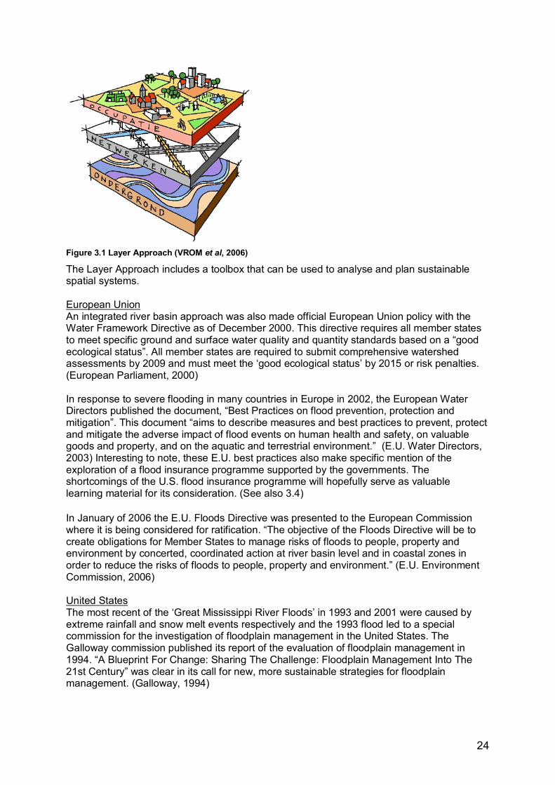
24
Figure 3.1 Layer Approach (VROM et al, 2006)
The Layer Approach includes a toolbox that can be used to analyse and plan sustainable spatial systems. European Union An integrated river basin approach was also made official European Union policy with the Water Framework Directive as of December 2000. This directive requires all member states to meet specific ground and surface water quality and quantity standards based on a �good ecological status�. All member states are required to submit comprehensive watershed assessments by 2009 and must meet the �good ecological status� by 2015 or risk penalties. (European Parliament, 2000) In response to severe flooding in many countries in Europe in 2002, the European Water Directors published the document, �Best Practices on flood prevention, protection and mitigation�. This document �aims to describe measures and best practices to prevent, protect and mitigate the adverse impact of flood events on human health and safety, on valuable goods and property, and on the aquatic and terrestrial environment.� (E.U. Water Directors, 2003) Interesting to note, these E.U. best practices also make specific mention of the exploration of a flood insurance programme supported by the governments. The shortcomings of the U.S. flood insurance programme will hopefully serve as valuable learning material for its consideration. (See also 3.4) In January of 2006 the E.U. Floods Directive was presented to the European Commission where it is being considered for ratification. �The objective of the Floods Directive will be to create obligations for Member States to manage risks of floods to people, property and environment by concerted, coordinated action at river basin level and in coastal zones in order to reduce the risks of floods to people, property and environment.� (E.U. Environment Commission, 2006) United States The most recent of the �Great Mississippi River Floods� in 1993 and 2001 were caused by extreme rainfall and snow melt events respectively and the 1993 flood led to a special commission for the investigation of floodplain management in the United States. The Galloway commission published its report of the evaluation of floodplain management in 1994. �A Blueprint For Change: Sharing The Challenge: Floodplain Management Into The 21st Century� was clear in its call for new, more sustainable strategies for floodplain management. (Galloway, 1994)
25
The Water Resources Development Act of 1999 builds on these recommendations. The Act �includes a provision, authorizing the [U.S. Army] Corps [of Engineers] to implement a programme, Flood Mitigation and Riverine Restoration (Challenge 21), for the formulation, design, and implementation of non-structural floodplain management projects. (USACEa, USACEb, 2000; White, 2000)
�...this initiative expands the use of non-structural options to achieve the dual purposes of flood damage reduction and the restoration of riverine ecosystems. Challenge 21 responds to those communities who have expressed a strong desire to aggressively reduce or even eliminate repeated losses and improve the quality of their environment by creating partnerships with these state, tribal and local entities, allowing their priorities to be realized�. (USACEa, 2000)
At the state level, the Association of State Floodplain Managers has also emerged as a leader in the development of policies and strategies. Their manifest �No Adverse Impact � states that:
�A �no adverse impact floodplain� is one in which the action of one property owner or community does not adversely affect the flood risks for other properties or communities as measured by increased flood stages, increased flood velocity, increased flows, or the increased potential for erosion and sedimentation, unless the impact is mitigated as provided for in a community or watershed based plan.� (Larson and Plasencia, 2001)
Clearly, the E.U. and U.S. are heading toward comprehensive advances in floodplain management policies and laws. As shown below, this trend will have to be watched closely to make sure they stay on track.
3.4 Challenges in the transition Netherlands The government in the Netherlands has, since the passage of the Room for the River directive, had another shift in policy. The minister of Housing, Spatial Planning and Environment proposed, in February 2006, that building in floodplains will now be allowed under certain strict conditions. In his May 10th speech, Minister Dekker laid out the new policy line of the ministry. Therein provisions are made to develop �outside the dikes�, as the Dutch refer to it, in order to stimulate �regional development possibilities�. (Dekker, P.W., 2006) The ministry wants to stimulate combinations of the land uses housing, businesses and water through innovative pilot projects involving floating structures and structures built on piles. Although the policy clearly states that safety and river functions come first, it is easy to imagine how such a policy could lead to the further development of structures within the floodplain and therefore increase the potential damage caused by flooding. United States After the Mississippi floods of 1993 (which broke flow records along 1600 km of rivers and caused 16 billion dollars in damage) massive property buyouts and relocations (even an entire town) were used as the new strategy to reduce structures in the floodplain and thereby the damage risks associated with flooding. Even with this knowledge, and the initiatives by the Army Corps of Engineers and the Association of State Floodplain managers, new development in and of floodplains continues. �Since 1993, the amount of such infrastructure has increased dramatically: [in the Mississippi basin] 28,000 new homes were built,
26
population increased 23%, and 26.8 km2 of commercial and industrial development were added on land that was inundated during the 1993 flood.� (Pinter, 2005) Pinter blames the FEMA guidelines with respect to the National Flood Insurance Program which �limit development in the central portion of the floodplain (the �floodway�), but allow virtually unlimited development across the rest of the floodplain so long as developed areas are either raised above the level of the 100-year flood (the event with a 1% chance of occurring in any year) or protected by levees with at least 100-year protection�. (Pinter, 2005) Pinter acknowledges that floodplain management has improved and that �successes outnumber the failures. The problem is when these measures succumb to local economic self-interest and political pressure, small local failures ─ like cracks in the levees themselves ─ allow massive increases in floodplain infrastructure that can rob the nation of all the net improvements painstakingly won elsewhere.� (Pinter, 2005; Larson and Plansencia, 2001)
3.5 What needs to be done Above are just a few examples of the threats facing the implementation of sustainable flood management strategies, even when mandated by law. The laws and policies are in place and in many places the will is present to make the shift to the new paradigm. But strategies must be brought from the strategic level down to the regional and local level. There can be no effect if there is no implementation. In order to support decision makers and give them evidence of the benefits the sustainable use of floodplains, it is imperative that research continues to give new, improved ways to translate strategies into practical policy implementation. The following chapters describe the analysis framework adapted in this study to help meet these goals.
3.6 One possible strategy: ecosystem management A recent study by Hale and Adams adapted the 10 themes of ecosystem management developed by Grumbine to develop �an idealized model of ecosystem management� to evaluate different approaches to the conservation of river floodplain systems. A Wisconsin river in the U.S. and a German river in Europe were compared (Hale and Adams, 2006; Grumbine, 1994, 1997). The themes provide �attributes� that can be �measured� for their presence or absence in project planning documents and implemented projects. These attributes can also be considered equivalent to ambitions for sustainability as discussed in section 1.1.1. The cases used in Hale and Adams� study were river reserves and as such had special protection. For this study, project areas do not have a reserve status, but have an extreme urban spatial component. For this reason the themes for ecosystem management used by Hale and Adams have been adapted for the evaluation of sustainable floodplain management in urban areas. When reviewing literature for an evaluation framework, this framework stood out because of its use of very broad categories under which the principles of sustainable floodplain management can be listed and made operational. A reproduction of Hale and Adams� framework as published in their study is included in Appendix 5.
27
3.7 Adapting the ecosystem management framework for use in sustainable urban floodplain management
The ecosystem framework designed by Dr. Hale has been adapted through a number of steps before being used to evaluate a number of cases.
1. For the adaptation of Hale and Adams� framework major differences between the reserve situation and the urban situation were identified. The main difference noted was the issue of safety. The need to �control� water systems in order to prevent damage and casualties due to extremely wet or dry conditions and meeting the needs of people with their residential and industrial land uses can be expected to outweigh the conservation of natural processes in urban areas.
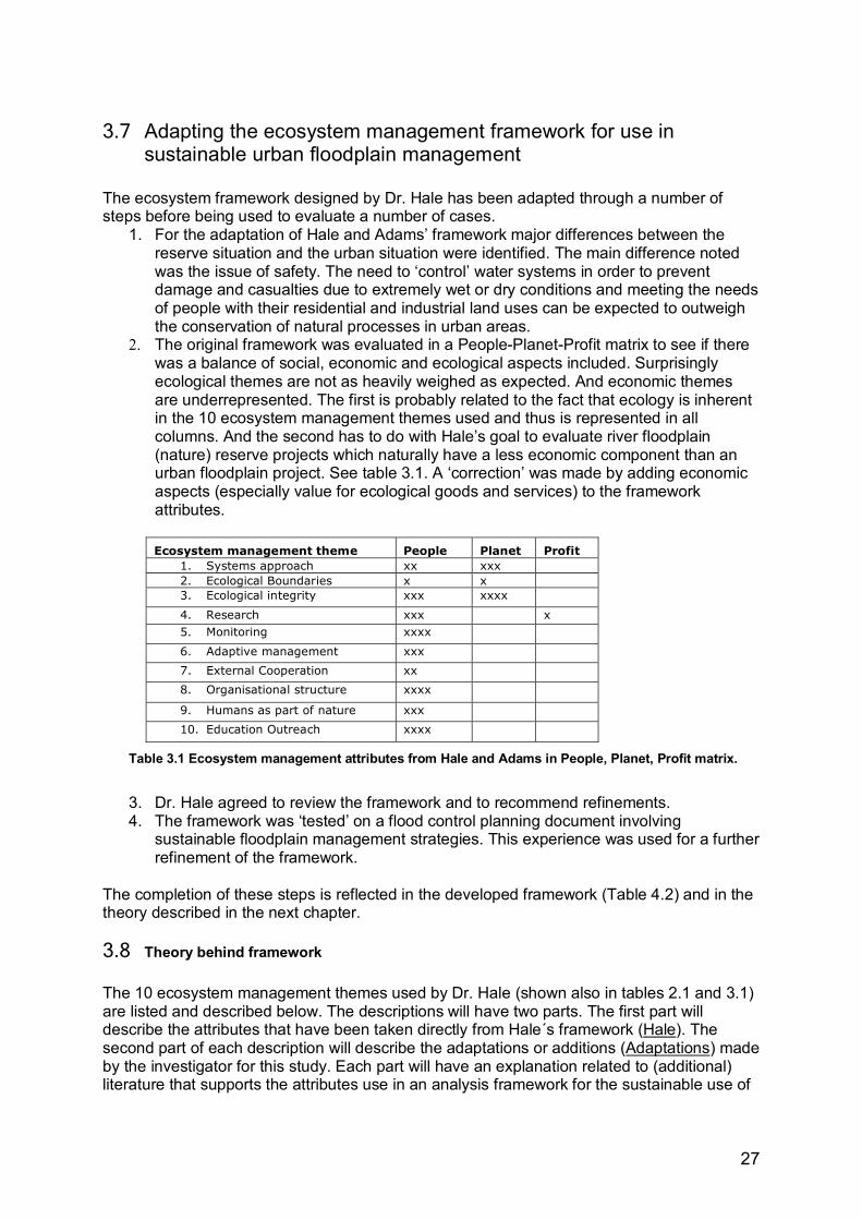
2. The original framework was evaluated in a People-Planet-Profit matrix to see if there was a balance of social, economic and ecological aspects included. Surprisingly ecological themes are not as heavily weighed as expected. And economic themes are underrepresented. The first is probably related to the fact that ecology is inherent in the 10 ecosystem management themes used and thus is represented in all columns. And the second has to do with Hale�s goal to evaluate river floodplain (nature) reserve projects which naturally have a less economic component than an urban floodplain project. See table 3.1. A �correction� was made by adding economic aspects (especially value for ecological goods and services) to the framework attributes.
Ecosystem management theme People Planet Profit
1. Systems approach xx xxx 2. Ecological Boundaries x x 3. Ecological integrity xxx xxxx
4. Research xxx x 5. Monitoring xxxx
6. Adaptive management xxx
7. External Cooperation xx
8. Organisational structure xxxx
9. Humans as part of nature xxx
10. Education Outreach xxxx
Table 3.1 Ecosystem management attributes from Hale and Adams in People, Planet, Profit matrix.
3. Dr. Hale agreed to review the framework and to recommend refinements. 4. The framework was �tested� on a flood control planning document involving
sustainable floodplain management strategies. This experience was used for a further refinement of the framework.
The completion of these steps is reflected in the developed framework (Table 4.2) and in the theory described in the next chapter.
3.8 Theory behind framework The 10 ecosystem management themes used by Dr. Hale (shown also in tables 2.1 and 3.1) are listed and described below. The descriptions will have two parts. The first part will describe the attributes that have been taken directly from Hale´s framework (Hale). The second part of each description will describe the adaptations or additions (Adaptations) made by the investigator for this study. Each part will have an explanation related to (additional) literature that supports the attributes use in an analysis framework for the sustainable use of

28
urban floodplains. Numbers, in brackets [ ], refer to the number of the attribute in the framework in the tables below and in table 4.2.
1. SYSTEMS APPROACH Theme Attribute
1. Do plans use a watershed, -system approach?2. Do goals focus on long term sustainability?
3. Are multiple scales used?4. Are resilience strategies used? (Is there an attempt to use natural processes to prevent damage due to flooding?)
5. Is retain, store and then drain used?6. Is the principle of no adverse impact (up- and downstream) used?7. Is groundwater management linked to surface water
Syst
ems
app
roac
h
Table 3.2 Systems approach attributes included in the framework
Hale Hale describes a systems approach as �big picture thinking that� that takes not only ecological processes but social and economic processes on multiple scales [3] into account. In this approach the focus is on long term sustainability [2]. (Hale and Adams, 2006) See table 3.2. Adaptations The investigator found it important to be more specific and included a watershed attribute [1]. This approaches assume �that all the processes operating within given catchments are linked by the system of the river� (Wolsink, 2006) and views the watershed or river basin as an ecosystem. The ecosystem concept used for this study explicitly includes the urban area as part of the ecosystem. (Wolsink, 2006; Newson, 1997, p. 107-108; Marchand and Toornstra, 1986; Grumbine, 1994;) Linked to the watershed approach are several specific indicators that refer to sustainable floodplain management strategies as described in chapter 3.3. These strategies are: - resilience strategies such as green rivers and stream restoration [4], (see also ecological
integrity), - the �retain, store and drain� principle [5], - the no adverse impact principle [6] - and the linking of groundwater management to surface water management [7]. This
concept comes from the layer approach mentioned in 3.3 where the consequences for surface water management should be accounted for in all the layers: ground, network and occupation layers. As such issues of subsidence and water table issues are important to consider. (VROM et al, 2006)
2. ECOLOGICAL BOUNDARIES
Theme Attribute
8. Are ecological boundaries used?
9. Do boundaries extend across political boundaries?
Ecol
ogic
al
boun
dari
es
Table 3.3 Ecological boundaries attributes included in the framework
29
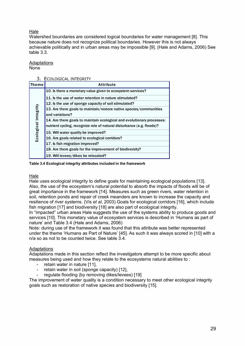
Hale Watershed boundaries are considered logical boundaries for water management [8]. This because nature does not recognize political boundaries. However this is not always achievable politically and in urban areas may be impossible [9]. (Hale and Adams, 2006) See table 3.3. Adaptations None
3. ECOLOGICAL INTEGRITY Theme Attribute
10. Is there a monetary value given to ecosystem services?
11. Is the use of water retention in nature stimulated?12. Is the use of sponge capacity of soil stimulated?13. Are there goals to maintain/restore native species/communities and variations?14. Are there goals to maintain ecological and evolutionary processes: nutrient cycling, recognize role of natural disturbance (e.g. floods)?
15. Will water quality be improved?16. Are goals related to ecological corridors?17. Is fish migration improved?18. Are there goals for the improvement of biodiversity?
19. Will levees/dikes be relocated?
Ecol
ogic
al in
tegr
ity
Table 3.4 Ecological integrity attributes included in the framework
Hale Hale uses ecological integrity to define goals for maintaining ecological populations [13]. Also, the use of the ecosystem�s natural potential to absorb the impacts of floods will be of great importance in the framework [14]. Measures such as green rivers, water retention in soil, retention ponds and repair of creek meanders are known to increase the capacity and resilience of river systems. (Vis et al, 2003) Goals for ecological corridors [16], which include fish migration [17] and biodiversity [18] are also part of ecological integrity. In �impacted� urban areas Hale suggests the use of the systems ability to produce goods and services [10]. This monetary value of ecosystem services is described in �Humans as part of nature� and Table 3.4 (Hale and Adams, 2006) Note: during use of the framework it was found that this attribute was better represented under the theme �Humans as Part of Nature� [45]. As such it was always scored in [10] with a n/a so as not to be counted twice. See table 3.4. Adaptations Adaptations made in this section reflect the investigators attempt to be more specific about measures being used and how they relate to the ecosystems natural abilities to :
- retain water in nature [11], - retain water in soil (sponge capacity) [12], - regulate flooding (by removing dikes/levees) [19]
The improvement of water quality is a condition necessary to meet other ecological integrity goals such as restoration of native species and biodiversity [15].
30
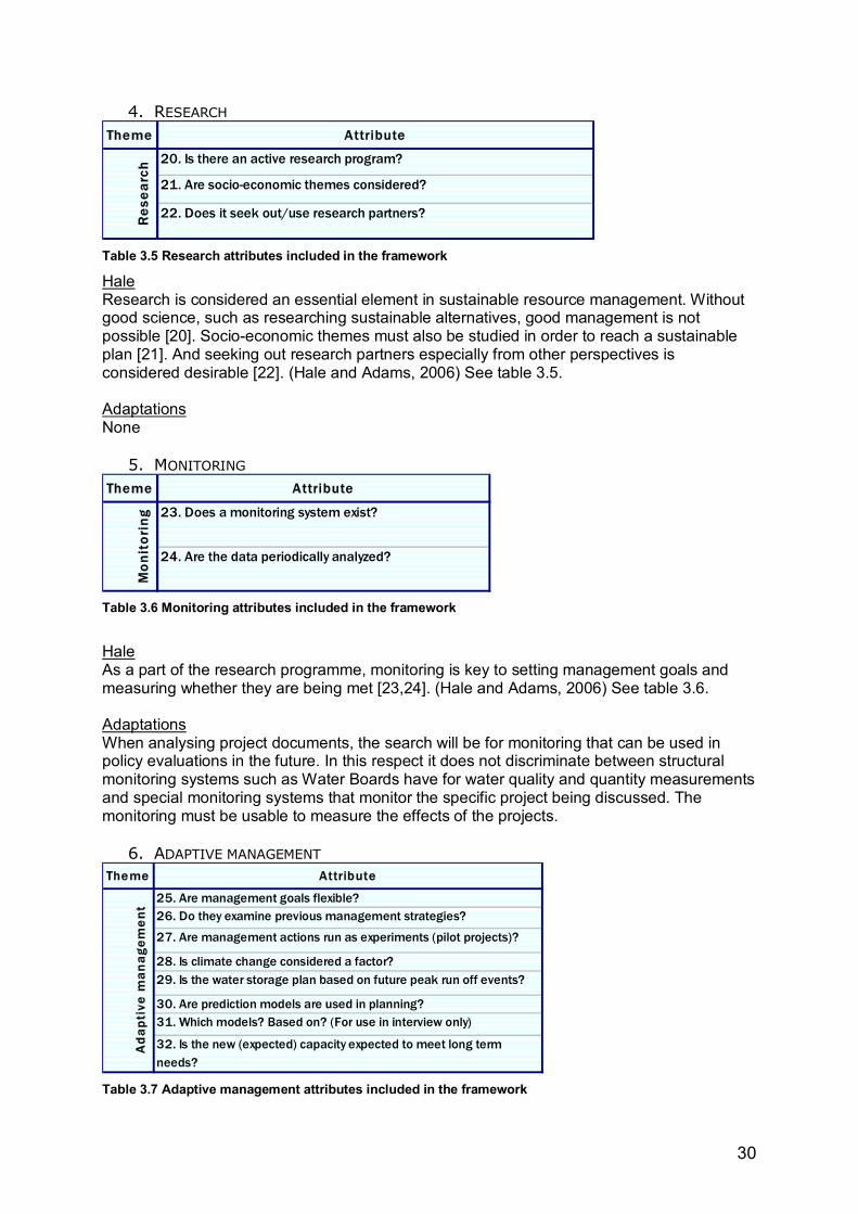
4. RESEARCH Theme Attribute
20. Is there an active research program?
21. Are socio-economic themes considered?
22. Does it seek out/use research partners?Res
earc
h
Table 3.5 Research attributes included in the framework
Hale Research is considered an essential element in sustainable resource management. Without good science, such as researching sustainable alternatives, good management is not possible [20]. Socio-economic themes must also be studied in order to reach a sustainable plan [21]. And seeking out research partners especially from other perspectives is considered desirable [22]. (Hale and Adams, 2006) See table 3.5. Adaptations None
5. MONITORING Theme Attribute
23. Does a monitoring system exist?
24. Are the data periodically analyzed?
Mon
itor
ing
Table 3.6 Monitoring attributes included in the framework
Hale As a part of the research programme, monitoring is key to setting management goals and measuring whether they are being met [23,24]. (Hale and Adams, 2006) See table 3.6. Adaptations When analysing project documents, the search will be for monitoring that can be used in policy evaluations in the future. In this respect it does not discriminate between structural monitoring systems such as Water Boards have for water quality and quantity measurements and special monitoring systems that monitor the specific project being discussed. The monitoring must be usable to measure the effects of the projects.
6. ADAPTIVE MANAGEMENT Theme Attribute
25. Are management goals flexible? 26. Do they examine previous management strategies?
27. Are management actions run as experiments (pilot projects)?
28. Is climate change considered a factor?29. Is the water storage plan based on future peak run off events?
30. Are prediction models are used in planning?31. Which models? Based on? (For use in interview only)
32. Is the new (expected) capacity expected to meet long term needs?
Ad
apti
ve m
anag
eme
nt
Table 3.7 Adaptive management attributes included in the framework
31
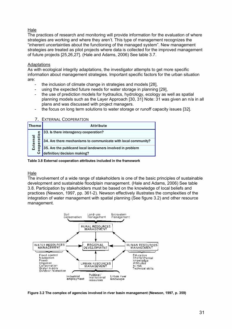
Hale The practices of research and monitoring will provide information for the evaluation of where strategies are working and where they aren�t. This type of management recognizes the �inherent uncertainties about the functioning of the managed system�. New management strategies are treated as pilot projects where data is collected for the improved management of future projects [25,26,27]. (Hale and Adams, 2006) See table 3.7. Adaptations As with ecological integrity adaptations, the investigator attempts to get more specific information about management strategies. Important specific factors for the urban situation are:
- the inclusion of climate change in strategies and models [28], - using the expected future needs for water storage in planning [29], - the use of prediction models for hydraulics, hydrology, ecology as well as spatial
planning models such as the Layer Approach [30, 31] Note: 31 was given an n/a in all plans and was discussed with project managers.
- the focus on long term solutions to water storage or runoff capacity issues [32].
7. EXTERNAL COOPERATION Theme Attribute
33. Is there interagency cooperation?
34. Are there mechanisms to communicate with local community?
35. Are the publicand local landowners involved in problem definition/decision making?
Exte
rnal
C
oope
rati
on
Table 3.8 External cooperation attributes included in the framework
Hale The involvement of a wide range of stakeholders is one of the basic principles of sustainable development and sustainable floodplain management. (Hale and Adams, 2006) See table 3.8. Participation by stakeholders must be based on the knowledge of local beliefs and practices (Newson, 1997, pp. 361-2). Newson effectively illustrates the complexities of the integration of water management with spatial planning (See figure 3.2) and other resource management.
Figure 3.2 The complex of agencies involved in river basin management (Newson, 1997, p. 359)
32
This interaction is reflected in the framework with the attributes: - interagency cooperation [33], - communication with the local community [34] and - involvement of public and landowners in decision making [35]
Cooperation with spatial planners will be reflected in the �Organisational structure� theme below. The other interactions shown above are essential but do not fall into the scope of this study. Adaptations None
8. ORGANISATIONAL STRUCTURE Theme Attribute
36. Does management seek consensus building and partnerships (vertical)?
37. Is there a horizontal flow (interdisciplinary collaboration) of information?
38. Do (zoning) regulations restrict functions within floodplains?
39. Are spatial planners and developers required to consult with water managers (water test)?
40. Is there a policy to gain ownership of floodprone lands for nature development?
41. Are permitting barriers acknowledged during the planning process?
41.a. Is sufficient funding expected? Org
anis
atio
nal s
truc
ture
Table 3.9 Organisational structure attributes included in the framework
Hale The organisational structure refers to the water management organisation, where vertical as well as horizontal (interdisciplinary) flow of information is important [36, 37] See table 3.9. Adaptations Important additions to this theme were made to try to reflect the organisation�s ability to implement its policies. This structure of laws and regulations within which these organisations must work and instruments they can use include:
- zoning laws and regulations[38] that prohibit development in floodplains; - requirements for spatial planners and water planners to work together such as the
Water Assessment [39] described in 3.3. In the Netherlands, this Water Assessment is considered a powerful instrument. Cooperation between water managers and spatial planners will be seen as essential in the planning of projects;
- policies to gain ownership of flood prone land [40]; - the permitting process which can present barriers to plan implementation [41]; - sufficient funding which is obviously crucial to plan implementation [41a]. Note: 41a is
numbered this way because it was added late in the framework development.
9. HUMANS AS PART OF NATURE Theme Attribute
42. Does management incorporate human uses?43. Does it attempt to shift non-sustainable uses and practices?
44. Does it respect cultural uses? 45. Are ecosystem goods and services used in flood damage prevention project planning?46. Is the value of ecosystem services used as compensation or incentive for land use change?47. Are peak water levels/run-off dynamics improved for flood damage prevention?
48. Is safety improved for the project area?49. Is safety improved up-, downstream?Hum
ans
as p
art
of n
atur
e
Table 3.10 Humans as part of nature attributes included in the framework
33
Hale This concept recognizes that human activities and development will continue in the system. As such management must:
- incorporate human uses such as housing, businesses and recreation [42], - attempt to shift to sustainable practices which balance the needs of the people with
those of the environment [43] and, - respect cultural uses [44] so that humans will benefit from the projects. See table
3.10. Adaptations A promising strategy for the sustainable use of natural resources is found in recognizing and valuing the �Benefits humans derive from (intact) freshwater ecosystems� as shown in table 3.11. Direct use of surface waters and ground waters
Products harvested from healthy freshwater ecosystems
Services provided by healthy freshwater ecosystems
- Preparation of food/drink - Fish and wildlife - Recreation (fishing, hunting, boating, swimming)
- Hygiene, waste disposal - Riparian products - Transportation of goods - Livestock production - Wetland products - Water storage/flood
control - Hydropower - Streambed minerals and
materials - Nutrient deposition/waste
purification - Cooling - Climatic moderation - Manufacturing - Buffering of polluted
inputs - Fire fighting - Aesthetics and mental
health
Table 3.11 Benefits of freshwater ecosystems (after Newson, 1997, p. 355; Naiman et al, 1995)
Learning to appreciate and use these benefits or ecosystem goods and services before they are lost or restoring ecosystems is a great challenge facing water managers world wide. A project in New York is a good example of the loss of ecosystem services (and the related cost) and their restoration.
�Before it became overwhelmed by agricultural and sewage runoff, the watershed of the Catskill Mountains provided New York City with water ranked among the best in the Nation by Consumer Reports. When the water fell below quality standards, the City investigated what it would cost to install an artificial filtration plant. The estimated price tag for this new facility was six to eight billion dollars, plus annual operating costs of 300 million dollars - a high price to pay for what once was free. New York City decided instead to invest a fraction of that cost ($660M) in restoring the natural capital it had in the Catskill�s watershed. In 1997, the City raised an Environmental Bond Issue and is currently using the funds to purchase land and halt development in the watershed, to compensate property owners for development restrictions on their land, and to subsidize the improvement of septic systems.� (ESA, 2000)
One way to give a value to ecosystem benefits is to compensate landowners for use of their land for water storage or by compensating them for maintaining floodplains on their land. The presence of such policies will be measured in planning projects [45, 46] Also, since this study focuses on urban floodplains, the investigator has also included the attribute of safety under this theme. This will be measured with the following attributes:
- improvement of peak water levels/runoff dynamics for the project area [47] - improvement of safety for the project area [48] - improvement of safety up- and down stream [49]
34
10.EDUCATION AND OUTREACH Theme Attribute
50. Is public education a goal?
51. Is there a public outreach program?
Educ
atio
n O
utre
ach
Table 3.12 Education and outreach attributes included in the framework
Hale Called �values� by Grumbine, this heading refers to the need for support for sustainable water management projects. If the public and stakeholders are informed about the need for sustainable practices they will be more likely to support measures that need to be taken. The public must for example feel that measures are valuable in that they will provide safety from flood damage or provide new opportunities for recreation [50, 51]. See table 3.11. Adaptations None
3.9 Relationship between the framework and the main research question
The framework is expected to show which strategies are being used and which are not. The absence of an attribute in a plan will be scored with a 0 and will indicate an area of weakness in the plan regarding the implementation of sustainable floodplain management principles. It is expected that the results when related to possible strategies that were not used can suggest improvements in planning strategies. The choice of a wide range of case studies was made in order to show a wide range of possible situations. It is expected that the differences found can suggest strategies that work in one place can also be applied to another place. A question one might ask now is what should the framework now be called? So far the adaptations fall well within the ecological management theme framework and so the name will not change. The value of the addition of certain attributes (which are expected to indicate the presence or absence of sustainable floodplain management principles in urban areas) will have to be determined based on the results acquired, their discussion and the conclusions made about them and the use of the framework. These judgements will be reserved for the final chapters of this report. How the framework is used will be described in Chapter 4.

35
Chapter 4 Cases studied in the framework
4.1 Case study presentation This chapter will describe the cases studied and evaluated in the ecosystem management framework. For each case the following will be described:
- a project description - factors in each case with respect to:
o water management o spatial planning o ecosystem management
- evaluation of the case within the framework At the end of this chapter Table 4.2 shows all case study scores in the framework.
4.1.1 Case study criteria As described in 2.2.3 the cases chosen have the following elements in common:
- Project areas are �urban� where the following factors apply:
o Risk of flood o Growing population o Increasing investment o Climate change
- Project area�s are located in low lying river delta systems. - Projects are of approximately the same size and scale. - Contact was made with project managers and agreements were reached over the
exchange of information. The Dutch cases were chosen because they are part of larger pilot projects dealing with sustainable floodplain management principles and as such should provide interesting strategies for the comparisons between the Dutch and American approaches. The Dynamic Brook Valley and the Reconstruction of the Tongelreep Valley fall under the European Interregional IIIb project �Nature-oriented flood damage prevention� which strives to use resilience strategies in floodplain management. The Hondsbroeksche Pleij is a �Room for the River� project that is also part of a European Interregional IIIb project �Sustainable Development of Floodplains�. In this respect they are all pilot projects that can provide valuable lessons for the implementation of sustainable floodplain management principles. The cases from Houston are different. Sims Bayou is a project initiated in the 1960�s with a plan dating back to 1983 . This plan was written by the U.S. Army Corp of Engineers as the agency responsible for nationally funded flood control projects. As such it will probably show less of the sustainable floodplain management practices that have been developing in the last 20-30 years. The Brays Bayou plan is more recent and is different from Sims Bayou. The newer laws for floodplain management allow the local sponsor, in this case Harris County Flood Control District, to be the primary planner in nationally funded projects. The difference between the �old� USACE approach and the newer HCFCD and Dutch approaches are expected to be visible in the results.
36
4.2 Using the framework The attributes are listed in the form of questions and are relevant for sustainable floodplain management in urban areas. The questions are formulated so that they can be answered with a yes, it is present (++), no, it is absent (0) or it is in development (+). When possible questions will be formulated so that a yes answer indicates the presence of an attribute that is considered sustainable. If an attribute could not have been expected to be present in a planning document due to the nature of the project an (n/a) for not applicable may be used. An ordinal score was chosen because the data that would be collected from projects using the framework does not lend itself to a more numerical interpretation. The only knowledge that could be gained was if one project scored higher or lower on an attribute than another project. Next to the score column is room for explanations and comments. These will be derived both from documents and interviews with project managers. Here valuable information from project managers is expected to provide insight into experiences working with sustainable floodplain management principles and what works and what doesn�t and why. See table 4.2 for an overview of the final framework. As mentioned in the ecological integrity description, number 10 was scored n/a in all plans to avoid counting it twice as it is so similar to [45]. And [31] was also scored n/a because models were not well represented in the plans and as such was reserved for discussion with project managers.
4.2.1 Data collection Data for the evaluation of each project have been obtained from various sources. For each case project planning documents, obtained from project managers, were searched for key words and information relating to the attributes in the framework. Planning documents were sometimes too narrowly focused on project design to measure all the attributes. In those cases the documents were viewed in the larger context of other strategic documents from the organisations involved. A list of the exact documents studied is found in Appendix 4. Detailed data collection tables, including search terms, are found in Appendix 6. Additionally, open interviews were held with the respective project managers for information about an attribute that could not be found in the documents. The framework was used as a loose structure for the interviews. Project managers were also asked what they would have done differently or what we could learn from their experiences. This information is also reflected in the data collection tables in Appendix 6. Transcripts from each interview are found in Appendix 7.
4.2.2 Scoring system As mentioned above, attributes were scored on an ordinal scale:
- ++ if an attribute was obviously present - 0 if it was obviously absent - + if the attribute was partially present or in development - (n/a) not applicable was given if an attribute could not have been expected to be
present due to the nature of the project

37
An ordinal score was chosen because the data that would be collected from projects using the framework does not lend itself to a more numerical interpretation. The only knowledge that could be gained was if one project scored higher or lower on an attribute than another document. Note: attribute number [10] is scored n/a in all cases because the same data is obtained with number [45]. This way the score would not be counted twice. Number [31] was also always answered with n/a because models were not well represented in planning documents. Modifications such as this, that took place after the final draft of the framework was made, will be described in the discussion.
38
4.3 Case A: Dynamic brook valley: River Aa, The Netherlands
4.3.1 Dynamic brook valley project description The River Aa is located in the province of North Brabant in the southern part of the Netherlands. The Dynamic brook valley project area begins at the Castle (Kasteel) Heeswijk weir and extends to just southeast of �s Hertogenbosch, also know as Den Bosch, a city of 135,000 people (see figure 4.1). The river flows from the Castle in the east toward and through Den Bosch in the west. The old meanders in this stretch of the Aa were straightened with many embankments and a heavily pumped drainage system was installed in the 1930�s for the protection of towns against flooding and for irrigation of farm land. Since then flooding has been uncommon. None the less, the extreme years of 1993, 1995 and 1998 resulted in critical water levels. (Grontmij, 2006, p. 1) Goals of the Dynamic brook valley project are:
- water retention - stream restoration - improvement of ecological corridors - improvement of water related recreation (Grontmij, 2006, p. vii)
Measures to be taken in the Aa valley include the restoration of meanders and removal of embankments and various water works to increase the water retention in the floodplain. See figure 4.1 and 4.2 for an overview of the project plan. These measures are expected to protect the cities of Middelrode, Berlicum and Den Bosch from damage due to flooding while at the same time restoring the natural functions and dynamics of the brook valley system. (Grontmij, 2006, p. 7; NOFDP, 2006)
4.3.2 Water management, spatial planning and ecosystem management factors of the Dynamic brook valley case
Water management In order to improve water retention and restore the natural functions of the Aa valley most embankments and one weir will be removed and meanders excavated and reconnected. The existing canalised Aa will be partially filled in. These measures will make it possible for natural processes, including flooding, to return to the Aa valley. (Grontmij, 2006, p. 5) The increased surface area for the floodplain will also meet the water retention goals. Measures taken are expected to decrease the amount of runoff in extreme situations (1/100 year) downstream at Den Bosch by 17% (Grontmij, 2006, p. viii). Spatial planning
In the Netherlands land use change must be reflected in the zoning map of the local municipalities. These maps have a legal status and the procedure to revise them can be costly and time consuming. Also permits must be obtained for a wide range of activities such as excavation, flora and fauna regulations and water system regulations. Space for retention and meanders must be found on existing farms. This will require cooperative agreements with farmers and other land owners. Plans are to set up a compensation system for farmers whose land is periodically inundated. In some cases arrangements will be made to construct dikes around sensitive properties.
39
Figure 4.1 Dynamic brook valley project area with projected meander at Hersend shown here in the red square and in figure 4.2. (Grontmij, 2006, Bijlage 1; Google Earth 2007; Castle Heeswijk, K. Becker)
Projected new Zuidwillemsvaart
N
● ● existing and projected pools ■■ ecological corridors ---- the projected Aa river bed
Dynamic Brook Valley measures map (Scale 1:20,000)
--●--●--●- plan area _______ projected and current Aa
40
Figure 4.2 Impression of Dynamic Brook Valley at Hersend (Grontmij, 2006, p. 12) from left to right: normal situation, once a year situation and 1 in 10 year situation This project area has two special planning considerations. There is a proposed road improvement on the N279 that will affect the Aa Valley and a proposed improvement to the Zuidwillemsvaart, a navigational channel that runs parallel to the Aa. Cooperation with the responsible parties, the province and the Dutch Department of Public Works will have direct influence on the success of the Aa project. Ecosystem management Ecological goals in the project plan include the improvement of ecological corridors and the restoration of the natural dynamics of the brook, with subsequent restoration of native species. The area around the Castle has been given the special status of a �wet nature pearl� by the province and as such has goals to develop nature with different characteristics than the dynamics strived for in the Dynamic brook project. This conflict will have to be resolved in the planning stages. From the information above one can conclude that without the cooperation of other parties the project could not be implemented. In the case of the Dynamic Brook Valley this will mean cooperation between the Water Board Aa and Maas as initiator of the plan with at least 2 municipalities, the Province, the Dutch Department of Transportation, 17 or more farmers, the public and many special interest groups. The project plan was approved in September of 2006 and implementation plans are being written. See Appendix 7.A. for comments from the project manager including a diagram of the organisation around the project.
4.3.3 Dynamic brook valley case evaluation in the framework As expected, based on the description above and because it is also part of the �Nature-oriented flood damage prevention project�, the Dynamic brook valley scores well in the framework. In this section the results will be explained per theme. See table 4.2 for results in the framework and Appendix 6.A. for the detailed data collection tables. Appendix 7.A. has a transcript of the interview conducted with the project manager in this case. In the systems approach category all aspects could be documented with explicit goals for long term (2050) and improving the resilience of the water system. The link between ground and surface water management scored only a plus because the ground water is monitored on a scale that would make it difficult to see effects within the brook valley. Ecological boundaries are evident in the use of the brook valley as a plan border. Ecological integrity scored overall well in the framework. Water retention is stimulated in nature and expected to deliver 3.3 million m3 of storage capacity. There are clear goals to stimulate habitat for target species and allow natural processes including sedimentation and inundation to occur. The ecological integrity category showed one weakness: the stimulation
41
of sponge capacity in soil is explicitly unwanted because of the effect a higher water table level would have on neighbouring farms. As in most of the cases, water quality is expected to improve only in an ecological sense. Chemical water quality is not expected to improve due to factors upstream. Other elements for the repair of the natural system are present such as ecological corridors in and along the brook which can be expected to improve biodiversity. Many dikes will be removed to restore the natural dynamic of the brook system. As noted in 3.7, attribute [10] was scored n/a in all cases. This attribute is repeated as number [45]. Research and monitoring are obviously present. Much research was done prior to project planning including social themes; economic themes were found to be underrepresented. Monitoring is not planned specifically for the project but is included in overall routine monitoring programmes of the water board. Adaptive management was clearly present in plans. For the water board this does not represent a pilot project except within the context of the Nofdp. The hydraulic models used were adequate to predict effects of 1 in 100 year events. This was considered adequate because more severe flooding would meet a number of barriers such as roads. According to the project manager, concerning external cooperation, getting the public as well as other agencies involved had not been done well when the plans were first initiated. This mistake cost the project many misunderstandings in the community and years of extra time (project was initiated in 1999 and the plan not approved until 2006). This lesson was well learned and corrected in the more recent stages of planning. The planning document used for evaluation reflects this improvement. (Pers. comm., Pastor, 2007) The organisational structure is crucial to plan success as mentioned above and scored very well in the framework. An extensive network has been constructed with the project manager represented at all levels. This organisational structure is shown in appendix 7.A. Humans as part of nature also scored well. Obvious was that the use of ecological goods and services is in development but procedures and calculation methods must still be negotiated and developed. It was made clear that the idea of arranging a payment system that compensates landowners at the outset for the use of their land for inundation was made unworkable. This sort of arrangement is seen by the E.U. as an agricultural subsidy and as such is unacceptable. (Pers. comm., Pastor, 2007) Public education was not a goal in the plan and public outreach is limited to flyers and public meetings. These were scored with a plus because they were not an explicit goal combined with the comments under external cooperation, i.e. there is possibility for improvement.
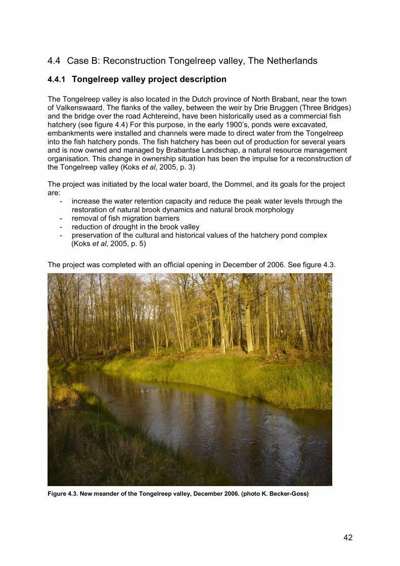
42
4.4 Case B: Reconstruction Tongelreep valley, The Netherlands
4.4.1 Tongelreep valley project description The Tongelreep valley is also located in the Dutch province of North Brabant, near the town of Valkenswaard. The flanks of the valley, between the weir by Drie Bruggen (Three Bridges) and the bridge over the road Achtereind, have been historically used as a commercial fish hatchery (see figure 4.4) For this purpose, in the early 1900�s, ponds were excavated, embankments were installed and channels were made to direct water from the Tongelreep into the fish hatchery ponds. The fish hatchery has been out of production for several years and is now owned and managed by Brabantse Landschap, a natural resource management organisation. This change in ownership situation has been the impulse for a reconstruction of the Tongelreep valley (Koks et al, 2005, p. 3) The project was initiated by the local water board, the Dommel, and its goals for the project are:
- increase the water retention capacity and reduce the peak water levels through the restoration of natural brook dynamics and natural brook morphology
- removal of fish migration barriers - reduction of drought in the brook valley - preservation of the cultural and historical values of the hatchery pond complex
(Koks et al, 2005, p. 5)
The project was completed with an official opening in December of 2006. See figure 4.3.
Figure 4.3. New meander of the Tongelreep valley, December 2006. (photo K. Becker-Goss)
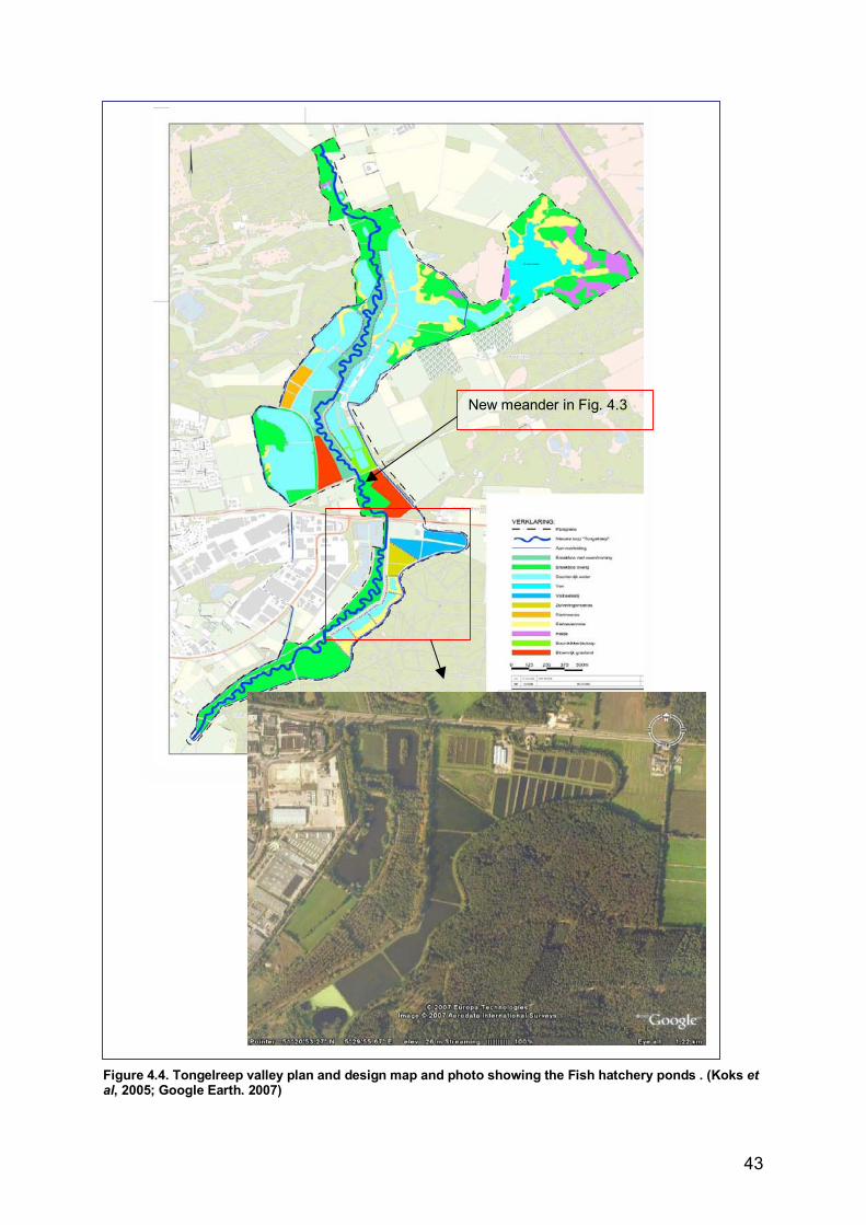
43
Figure 4.4. Tongelreep valley plan and design map and photo showing the Fish hatchery ponds . (Koks et al, 2005; Google Earth. 2007)
New meander in Fig. 4.3
44
4.4.2 Water management, spatial planning and ecosystem management factors of the Tongelreep valley case
Water management Water management goals for added water retention and reduction of peak water levels were met with the restoration of meanders with an overflow floodplain alongside the brook and the reconstruction of the fish ponds. (Koks et al, p. 6) Spatial planning The project has a fairly simple spatial planning element. In this case all necessary land is owned either by the Brabantse Landschap or by the water board. So lengthy negotions over land use change were not necessary. The zoning maps did require revision and this proved to be a hurdle for the project. The project area had been designated for water retention and nature development in the Provincial �reconstruction� plan which were drawn up to deal with the changing situation in Dutch agriculture. These reconstruction plans have a legal status and are supposed to work directly without the need for a zoning map revision. After revisions to 7 zoning maps within 3 municipalities, the project manager could say that this did not happen in practice. See Appendix 7.B. for his comments. Ecosystem management The project area is part of the national ecological infrastructure and is also a European Habitat Framework area with special status. Fish migration will be made possible by the installation of a fish ladder and water quality will be improved for ponds downstream by the installation of a reed swamp (helophyte filter) for water filtration. There are also features installed for nature oriented recreation such walking routes and a bird watching tower.
4.4.3 Tongelreep Valley case evaluation in the framework Like the Dynamic brook valley, the Tongelreep valley is a part of the NOFDP project and as such scored well in the framework. It was necessary to use the strategic water board document in combination with the Tongelreep Layout document to see the project in a bigger context. In this section the results will be explained per theme. See table 4.2 for results in the framework and Appendix 6.B. for the detailed data collection tables. Appendix 7.B. has a transcript of the interview conducted with the project manager in this case. A systems approach with clear goals for sustainability was evident in the documents. Ecological boundaries have been used with the borders of the stream valley. Ecological integrity is clearly promoted. Again in this project the use of water retention in soil is problematic due to other land uses in the area. Goals for biodiversity were not explicit although there are clear goals for a wide variety of flora and fauna. In this plan some embankments will be removed or lowered, but the embankments around the fish hatchery ponds will be kept intact to meet water storage goals. Research is evident in the many reports made in early planning stages and in the involvement in the Nofdp where the goal is to develop a �decision support system�. Monitoring is accounted for in the routine monitoring network by the water board. The project manager also made it clear that the measures taken in this project are not new to the water board, so they have a good idea of what the effects will be. (Pers. comm. van Betuw, 2007)
45
Adaptive management scores well overall. The models used in planning did not, however, include climate change prediction scenarios so those aspects scored lower. The project manager is confident that the changes in runoff volumes will be picked up by the routine monitoring network and that the water board is flexible enough to adapt to these future changes. External cooperation was evident in the signing of a copperative agreement with stakeholders. Organisational structure scored overall well, but the permitting barriers (changing the municipal zoning maps) mentioned above under spatial planning resulted in the low score here and the need for improvement. Humans as part of nature attributes scored well. The value of ecosystem services is clearly in development, not specifically in this project, but in other projects within the water board. Education and outreach score well. This is a clearly stated goal within the water board�s strategic mission and is reflected in the efforts to inform and involve the public.
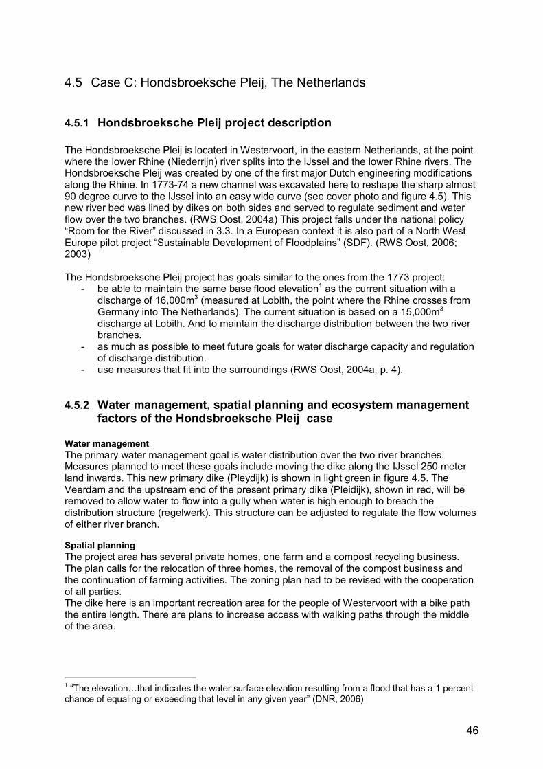
46
4.5 Case C: Hondsbroeksche Pleij, The Netherlands
4.5.1 Hondsbroeksche Pleij project description The Hondsbroeksche Pleij is located in Westervoort, in the eastern Netherlands, at the point where the lower Rhine (Niederrijn) river splits into the IJssel and the lower Rhine rivers. The Hondsbroeksche Pleij was created by one of the first major Dutch engineering modifications along the Rhine. In 1773-74 a new channel was excavated here to reshape the sharp almost 90 degree curve to the IJssel into an easy wide curve (see cover photo and figure 4.5). This new river bed was lined by dikes on both sides and served to regulate sediment and water flow over the two branches. (RWS Oost, 2004a) This project falls under the national policy �Room for the River� discussed in 3.3. In a European context it is also part of a North West Europe pilot project �Sustainable Development of Floodplains� (SDF). (RWS Oost, 2006; 2003) The Hondsbroeksche Pleij project has goals similar to the ones from the 1773 project:
- be able to maintain the same base flood elevation1 as the current situation with a discharge of 16,000m3 (measured at Lobith, the point where the Rhine crosses from Germany into The Netherlands). The current situation is based on a 15,000m3 discharge at Lobith. And to maintain the discharge distribution between the two river branches.
- as much as possible to meet future goals for water discharge capacity and regulation of discharge distribution.
- use measures that fit into the surroundings (RWS Oost, 2004a, p. 4).
4.5.2 Water management, spatial planning and ecosystem management factors of the Hondsbroeksche Pleij case
Water management The primary water management goal is water distribution over the two river branches. Measures planned to meet these goals include moving the dike along the IJssel 250 meter land inwards. This new primary dike (Pleydijk) is shown in light green in figure 4.5. The Veerdam and the upstream end of the present primary dike (Pleidijk), shown in red, will be removed to allow water to flow into a gully when water is high enough to breach the distribution structure (regelwerk). This structure can be adjusted to regulate the flow volumes of either river branch. Spatial planning The project area has several private homes, one farm and a compost recycling business. The plan calls for the relocation of three homes, the removal of the compost business and the continuation of farming activities. The zoning plan had to be revised with the cooperation of all parties. The dike here is an important recreation area for the people of Westervoort with a bike path the entire length. There are plans to increase access with walking paths through the middle of the area.
1 �The elevation�that indicates the water surface elevation resulting from a flood that has a 1 percent chance of equaling or exceeding that level in any given year� (DNR, 2006)
47
Ecosystem management The area between the proposed new �Pleydijk� and the old Westervoort �banddijk� (shown in black dotted line in figure 4.5) has a remnant of an old river branch (strang). This strang will be slightly lengthened and widened to increase the already high natural value. The area is zoned as a nature area and will be made more accessible to the public with walking paths. Many permits for the protection of flora and fauna, especially bats and birds, are necessary for the construction in the area.
4.5.3 Hondsbroeksche Pleij case evaluation in the framework As expected the Hondsbroeksche Pleij project, as part of the Room for the River and SDF projects, scored well in the framework. In this section the results will be explained per theme. See table 4.2 for results in the framework and Appendix 6.C. for the detailed data collection tables. Appendix 7.C. has a transcript of the interview conducted with the project manager in this case. The systems approach is very strongly present in the plan especially when seen in the SDF context where 12 projects will be implemented as a larger project along the German and Dutch stretches of the Rhine. Calculations for measures here are dependant on the measures taken in other areas. (RWS Oost, 2003) The use of ecological boundaries was not present in the plan area itself, but, again, seen in the larger context, the Rhine river basin is used as a boundary. Ecological integrity is evident in the obvious use of water retention in nature and in the recognition of flooding as a natural process. Sponge capacity in soil is explicitly not used. The ground water table is so high in the area, and only gets higher with high river levels, that there is a special �kwelvenster� or ground water outlet with a pump necessary to keep ground water levels in Westervoort at acceptable levels. Fish migration is not considered applicable because the high water gully will be dry most of the year. The are no specific goals for the improvement of water quality or biodiversity. Water quality is not expected to change. Biodiversity goals are not explicit, but with the nature areas it is expected to improve. And as mentioned in the project description, dikes will be moved to create more �room for the river�.
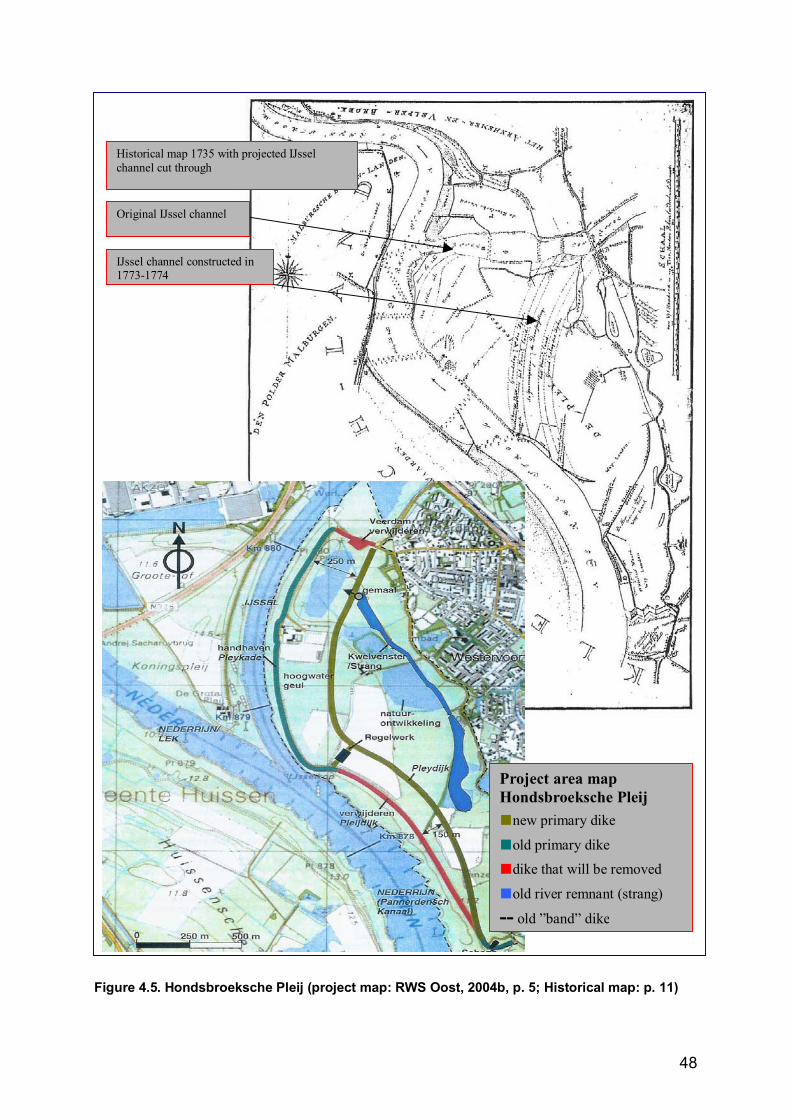
48
Figure 4.5. Hondsbroeksche Pleij (project map: RWS Oost, 2004b, p. 5; Historical map: p. 11)
Historical map 1735 with projected IJssel channel cut through
Project area map Hondsbroeksche Pleij ■new primary dike ■old primary dike ■dike that will be removed
■old river remnant (strang)
-- old �band� dike
IJssel channel constructed in 1773-1774
Original IJssel channel
49
Research and monitoring were evident in the Room for the River project context and the E.U. �Sustainable Development of Floodplains� project of which the Hondsbroeksche Pleij is a part. Transnational exchange of information is a key goal here. Management goals were clearly flexible and consider climate change and previous strategies. Past management schemes and the history of the area were both considered. The distribution structure is also meant to be adaptable to changing conditions. External cooperation scored well. In speaking with the project manager it was made clear how important going into the field was in reaching consensus with stakeholders. (Pers. comm. Eerden, 2007) The organisational structure is well equipped for this project. The status of the project as a national strategic project and as an E.U. pilot project ensures funding and cooperation between many parties. There is no explicit policy to acquire flood prone lands; the plan states a goal to have landowners cooperate on a voluntary basis. Humans as part of nature was evident in the plans for recreational access to the area and in aims to improve safety. The use of ecosystem goods and services is not explicit, but there are plans to compensate landowners (the farmer) for flood damages and for maintenance of dikes and other project structures. No explicit goals for education and outreach were found, but are evident within the SDF and in an active public information campaign in the Westervoort, where the investigator lives.
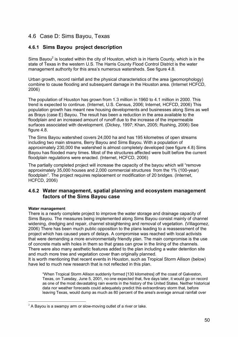
50
4.6 Case D: Sims Bayou, Texas
4.6.1 Sims Bayou project description Sims Bayou2 is located within the city of Houston, which is in Harris County, which is in the state of Texas in the western U.S. The Harris County Flood Control District is the water management authority for this area�s numerous watersheds. See figure 4.8. Urban growth, record rainfall and the physical characteristics of the area (geomorphology) combine to cause flooding and subsequent damage in the Houston area. (Internet HCFCD, 2006) The population of Houston has grown from 1.3 million in 1960 to 4.1 million in 2000. This trend is expected to continue. (Internet, U.S. Census, 2006; Internet, HCFCD, 2006) This population growth has meant new housing developments and businesses along Sims as well as Brays (case E) Bayou. The result has been a reduction in the area available to the floodplain and an increased amount of runoff due to the increase of the impermeable surfaces associated with development. (Dickey, 1997; Khan, 2005; Rushing, 2006) See figure 4.8.
The Sims Bayou watershed covers 24,000 ha and has 195 kilometres of open streams including two main streams, Berry Bayou and Sims Bayou. With a population of approximately 230,000 the watershed is almost completely developed (see figure 4.8) Sims Bayou has flooded many times. Most of the structures affected were built before the current floodplain regulations were enacted. (Internet, HCFCD, 2006)
The partially completed project will increase the capacity of the bayou which will �remove approximately 35,000 houses and 2,000 commercial structures from the 1% (100-year) floodplain�. The project requires replacement or modification of 20 bridges. (Internet, HCFCD, 2006)
4.6.2 Water management, spatial planning and ecosystem management factors of the Sims Bayou case
Water management There is a nearly complete project to improve the water storage and drainage capacity of Sims Bayou. The measures being implemented along Sims Bayou consist mainly of channel widening, dredging and repair, channel straightening and removal of vegetation. (Villagomez, 2006) There has been much public opposition to the plans leading to a reassessment of the project which has caused years of delays. A compromise was reached with local activists that were demanding a more environmentally friendly plan. The main compromise is the use of concrete mats with holes in them so that grass can grow in the lining of the channels. There were also many aesthetic features added to the plan including a water detention site and much more tree and vegetation cover than originally planned. It is worth mentioning that recent events in Houston, such as Tropical Storm Allison (below) have led to much new research that is not reflected in this plan.
�When Tropical Storm Allison suddenly formed [130 kilometres] off the coast of Galveston, Texas, on Tuesday, June 5, 2001, no one expected that, five days later, it would go on record as one of the most devastating rain events in the history of the United States. Neither historical data nor weather forecasts could adequately predict this extraordinary storm that, before leaving Texas, would dump as much as 80 percent of the area's average annual rainfall over
2 A Bayou is a swampy arm or slow-moving outlet of a river or lake.
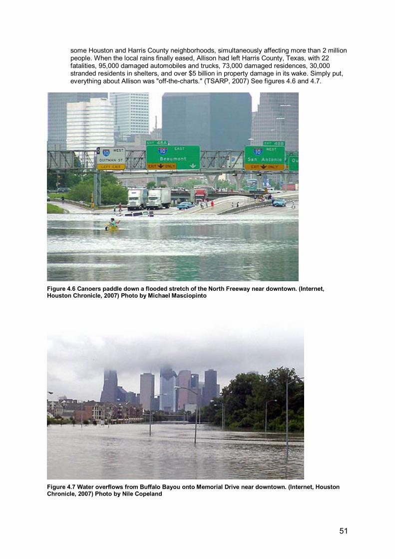
51
some Houston and Harris County neighborhoods, simultaneously affecting more than 2 million people. When the local rains finally eased, Allison had left Harris County, Texas, with 22 fatalities, 95,000 damaged automobiles and trucks, 73,000 damaged residences, 30,000 stranded residents in shelters, and over $5 billion in property damage in its wake. Simply put, everything about Allison was "off-the-charts." (TSARP, 2007) See figures 4.6 and 4.7.
Figure 4.6 Canoers paddle down a flooded stretch of the North Freeway near downtown. (Internet, Houston Chronicle, 2007) Photo by Michael Masciopinto
Figure 4.7 Water overflows from Buffalo Bayou onto Memorial Drive near downtown. (Internet, Houston Chronicle, 2007) Photo by Nile Copeland
52
Spatial planning �The upper reach of the watershed drains Missouri City and the lower reach of the watershed drains the cities of South Houston and Pasadena�, so cooperation between municipalities is important. One consequence of the channel widening along the bayou is the need to replace or reconstruct 20 bridges. Permits will be required for the bridges and a total of 375 hectares of additional right-of-way must be obtained. (Internet HCFCD, 2006) See figure 4.8. Other issues are the need to purchase rights-of-way in a heavily urbanised area. Massive floodplain buyouts were abandoned early in the planning as infeasible. This difficult relationship between city (spatial) planning and water management is also evident in the exclusion of lateral drainage problems from the plan even though, �problems are further compounded by inadequate storm sewers and lateral drainage ditches and tributary streams which retard runoff to the bayou.� (USACE, 1982) Ecosystem management Plans include the construction of bike trails and park areas along the Bayou. This multiple use of space is expected to increase the spatial and ecological value of the area.
4.6.3 Sims Bayou case evaluation in the framework The Sims Bayou case scores lower than the previous cases. This was expected due to the long planning history of the project and the age of the plans that were evaluated (1992 and 1983). In this section the results will be explained per theme. See table 4.2 for results in the framework and Appendix 6.D. for the detailed data collection tables. For this case interview data could not (yet) obtained. A previous conversation with the project manager and the interview with the Brays Bayou manager provided additional information. (See Appendix 7.D. and 7.E.) A systems approach was evident in the descriptions of the (sub-) watershed relationships in the area, but the �lateral� water drainage problems were specifically left out of the plan. These are the City of Houston�s responsibility, which provides evidence that the use of multiple scales could be improved. Also, Sims Bayou is a tributary of Buffalo Bayou but �to develop a comprehensive plan for the control of floods in the remaining areas of the Buffalo Bayou watershed�.study [has been] conducted on tributary by tributary basis� due to changing needs and rapid growth of Houston, (USACE 1882, p. 7). Related to this is an explored alternative to construct a 40 kilometre long diversion channel, or bypass, that would have diverted water from Sims Bayou, as well as contributing to flood control of Clear Creek, Hickory Slough, Turkey Creek and Armand Bayou, directly to an outlet into Galveston Bay. This alternative was dropped early in the planning due to its high cost and low benefit ratio. (USACE, 1982, p. 49) Below table 4.1 shows an overview of the costs of this channel diversion compared to the alternative that was chosen: Plan description Initial costs Annual
costs Annual benefits
Benefits to costs ratio
Net benefits
50 year channel improvements
$123,050,000 $10,775,000 $111,776,000 10.37 $101,001,000
Channel diversion $444,276,000 $51,056,000 $117,928,000 2.31 $66,872,000 Table 4.1 �Economics of preliminary plans� showing the comparison of calculations for the chosen plan of channel modifications over the channel diversion plan (after USACE, 1982, p. 54)

53
Figure 4.8. Watersheds of Harris County, location in Texas and details of the Sims Bayou project area (Internet HCFCD, 2006; Google Earth 2007)
54
The plan recognises that subsidence is a problem but that is another agency�s responsibility. Resilience strategies were not used; goals were clearly for water drainage. Only recently, with the implementation of the plan, were retention areas added. Ecological boundaries were used in the sense that watershed boundaries are used for project boundaries. These do cross political boundaries and make it important for local authorities to participate in planning. Ecological integrity does not score well in the framework. As mentioned above, water retention was added late in the process and water storage in soil is not considered a goal, or necessary, by the project managers. Goals for native species are not specific; there is a mention of planting native trees if locally available and affordable. Goals or the use of natural processes is explicitly excluded. The main goal is drainage and the channel must be wide, smooth and relatively straight to accommodate this. There were concessions made to the public interest groups by choosing a concrete lining with holes in it so that grass could grow on the sides of the channels. Water quality is not expected to improve and is poor due to the main sources of water in the Bayou: local runoff and effluent from local water treatment plants. Goals for the improvement of fish migration and biodiversity are not present which is related to the poor water quality. Levees will not be removed, or heightened, the channels profiles will be widened. Research is represented in the many research reports referred to in the plans. Socioeconomic themes are well represented as would be expected in such an urban environment. Monitoring does occur, but by another agency and not for the effects of this project. Adaptive management does not score well. Goals are set: prevent damage due to flooding. There is some evidence that previous management strategies were examined. Climate change is not considered a significant factor. And modelling is present and is modelled on a 50 year event. External cooperation is definitely present, but there is no evidence of cooperation between the stormwater management agency (City of Houston) and USACE or HCFCD. And the reason for the new plan is that public participation was lacking in the original plan. Organisational structure is present in the plans. A policy to gain ownership of flood prone lands is partially present, but only if monetary benefits exceed the cost of buyout. Again horizontal flow of information shows little integration of stormwater infrastructure in the plan. Humans as part of nature is well represented in the prevention of damage due to flooding categories. Safety will improve once the project is complete. But shifting to sustainable practices (as the resilience strategies are seen in this study) is not a goal and is not considered feasible. Compensation for ecosystem services is evident only in property buyouts, the cost of which must first be weighed against economic benefits. Public education and outreach are not explicit goals in the plans. It is evident that this is improving but largely due to the public opposition to the first plan. More improvement is seen in the Brays Bayou plan and is seen in the recent publications about Sims Bayou. (Internet, HCFCD, 2006)
55
4.7 Case E: Brays Bayou, Texas
4.7.1 Brays Bayou project description �The Brays Bayou watershed is situated [adjacent to Sims Bayou] within a humid region of Texas, which maintains subtropical weather during all parts of the year, especially the summer primarily due to the proximity of the Gulf of Mexico. This area of Texas is subject to both intensive local thunderstorms of relatively short duration and thunderstorms that may stall and persist for several days. In addition, this region is subject to violent storms associated with tropical disturbances, including occasional hurricanes. Annual rainfall in the Houston area is generally 45 inches [114cm] per year.� (PBS&J, 2006, p. 4-2) Like Sims Bayou, Brays Bayou is sub-watershed of the Buffalo Bayou. In 1990, a flood control project was planned for Brays Bayou that consisted of two major elements: a detention element and a diversion element. The upstream �detention element� includes canalisation and regional detention basins in the upper reaches of Brays Bayou. See figure 4.9. This part of the plan was authorized and implementation is underway. This upstream detention element will not be included in this case study. The planned downstream �diversion element� consisted of channels and dams diverting flows from Keegans Bayou and portions of Willow Waterhole Bayou to a detention site on Sims Bayou. HCFCD determined in a re-evaluation of the plan that the separate diversion element could no longer be implemented as proposed in the authorized Brays Bayou project due to technical infeasibility and public opposition. The plan discussed for this case study is the alternative to the original downstream plan and is called �Alternative to the Diversion Separable Element�. (PBS&J, 2006, p. 1-4) The objectives of this Brays Bayou downstream element project are:
- �Reduce residential and business flooding caused by large flows in Brays Bayou. - Minimize cost. - Maximize the economic benefits to the community. - Avoid and minimize adverse impacts to the environment. - Enhance or improve the aesthetics, environmental quality, and existing recreational
amenities where possible. Requirements:
- The general support of the affected citizens and businesses in the watershed is desirable.
- The project must conform to the mission of the HCFCD. - No adverse flood impacts may be created by the implementation of the proposed
action. - No diversion outside of the watershed would be considered.� (PBS&J, 2006, p. 2-2)
56
Figure 4.9. Brays Bayou downstream project area showing bridges to be modified with detail of Texas Medical Center area (Internet, HCFCD, 2006; Google Earth, 2007)
57
4.7.2 Water management, spatial planning and ecosystem management factors of the Brays Bayou case
Water management The downstream element project described here is urban over 95% of its area (see figure 4.9). Without measures an estimated 17,000 structures would be at risk, including the Texas Medical Center. Damages for a 100 year event are estimated at $1.8 billion. The downstream element of Brays Bayou will:
- widen 28 kilometres of channel - build a stormwater detention facility at Willow Waterhole Bayou - and modify or replace 28 bridges to remove obstructions in the channel
(PBS&J, p. 3-2) In considering other alternatives, flooplain buyouts and levee construction were excluded because of the high initial costs. (HCFCD, 2000) Spatial planning An estimated 6 structures for channel widening and another 5 structures (with 96 hectares) for the detention sites will have to be acquired. Permits for the bridge modifications will also be required. (PBS&J, p. 5-21) Also, in light of the Tropical Storm Allison story, it is worth adding that the local community, namely the Texas Medical Center, have been designing their own urban stormwater strategies, such as the use of green roofs, permeable concrete and local infiltration systems (Skidmore et al, 2005). Ecosystem management There are plans to plant approximately 6000 trees and 6000 shrubs and to add recreational and park elements to the channel slopes and detention facility. (PBS&J, p. 5-1) See figure 4.10. (Internet, HCFCD, 2006) Local participation has led to these aesthetic additions to the plan. The economic importance of the area leaves little room for ecological concerns. It must be noted that the downstream element of Bray�s Bayou is influenced by tide fluctuations. This is not considered a factor for this study.
Figure 4.10. Brays Bayou channel designs (Internet, HCFCD, 2006)

58
4.7.3 Brays Bayou case evaluation in the framework The Brays Bayou plan, being more recent, has as expected scored better than Sims Bayou in the framework. In this section the results will be explained per theme. See table 4.2 for results in the framework and Appendix 6.E. for the detailed data collection tables. A transcript of the interview with the Brays Bayou manager is found in Appendix 7.E. There is clearly a watershed approach to the project but as in Sims Bayou, the economic component is weighed heavily. The resilience strategies are not used (except detention) due to lack of space and high the economic risks. Groundwater is not a concern for the project. Ecological boundaries are used in the form of the watershed boundaries and again these extend over city and municipal borders. The extent of urbanisation makes it difficult to make improvements in ecological integrity. The unlikely impacts on wildlife are reflected in the low scores in this category. Research and monitoring are clearly present. Several hydraulic models have been developed for this project. Adaptive management scores reflect the fact that this plan is a re-evaluation of a previous plan. Again climate change is not considered a significant factor. Questions about the long term capacity of the new system went unanswered. Only that the damage from a 1/100 year event was reduced by 75%. External cooperation is well represented in the list of organisations and public actors involved. Here there is specific mention of cooperation with the City of Houston Department of Planning and Development. The organisational structure is well accounted for. The floodplain restrictions have to be found in local ordinances that require developers to prove that they have mitigated detention needs for all new developments. As in Sims Bayou funding must be requested from Congress every year and external factors can have great influence on how much money is available each year. (Pers. comm. Raouf Farid, 2007) Humans as part of nature scored well overall. The value of ecosystem services is not explicitly used, but there is a policy to buy-out structures if other solutions can�t be found. Public education and outreach are not goals, but are present in the many references to public meetings and the importance of participation. Made clear by the project manager was that the public also has the right to vote for these proposals and as such can heavily influence project funding. (Pers. comm. Farid, 2007)
4.8 Case study scores in the framework For scores of all the case studies see table 4.2. These results will be further analysed in chapter 5.
59
Dyn
amic
br
ook
valle
y
Tong
el-
reep
val
ley
Hon
ds
broe
ksch
e pl
eij
Sim
s B
ayou
Bra
ys
Bay
ou
1. Do plans use a watershed, -system approach? ++ ++ ++ + ++2. Do goals focus on long term sustainability? ++ ++ ++ + +3. Are multiple scales used? ++ ++ ++ + ++4. Are resilience strategies used? (Is there an attempt to use natural processes to prevent damage due to flooding?)
++ ++ ++ 0 +
5. Is retain, store and then drain used? ++ ++ ++ + +6. Is the principle of no adverse impact (up- and downstream) used? ++ ++ ++ ++ ++7. Is groundwater management linked to surface water management? + ++ ++ + +8. Are ecological boundaries used? ++ + + ++ ++
9. Do boundaries extend across political boundaries? ++ ++ ++ ++ ++
10. Is there a monetary value given to ecosystem services? n/a n/a n/a n/a n/a11. Is the use of water retention in nature stimulated? ++ ++ ++ + ++
12. Is the use of sponge capacity of soil stimulated? 0 0 0 0 013. Are there goals to maintain/restore native species/communities and variations? ++ ++ + + ++
14. Are there goals to maintain ecological and evolutionary processes: nutrient cycling, recognize role of natural disturbance (e.g. floods)?
++ ++ ++ 0 +
15. Will water quality be improved? + ++ 0 0 +16. Are goals related to ecological corridors? ++ ++ ++ 0 017. Is fish migration improved? ++ ++ n/a 0 018. Are there goals for the improvement of biodiversity? ++ + + 0 019. Will levees/dikes be relocated? ++ + ++ + +20. Is there an active research program? ++ ++ ++ + ++21. Are socio-economic themes considered? + + ++ ++ ++
22. Does it seek out/use research partners? ++ ++ ++ + +
23. Does a monitoring system exist? + ++ ++ + ++
24. Are the data periodically analyzed? + ++ ++ + ++
25. Are management goals flexible? ++ ++ ++ 0 ++26. Do they examine previous management strategies? ++ ++ ++ + ++
27. Are management actions run as experiments (pilot projects)? + ++ ++ 0 ++
28. Is climate change considered a factor? ++ + ++ + 029. Is the water storage plan based on future peak run off events? ++ + ++ ++ +30. Are prediction models are used in planning? ++ ++ ++ + ++31. Which models? Based on? (For use in interview only) n/a n/a n/a n/a n/a32. Is the new (expected) capacity expected to meet long term needs? ++ + ++ + +33. Is there interagency cooperation? ++ ++ ++ + ++
34. Are there mechanisms to communicate with local community? ++ ++ ++ ++ ++
35. Are the publicand local landowners involved in problem definition/decision making?
++ ++ ++ + ++
36. Does management seek consensus building and partnerships (vertical)?
++ ++ ++ ++ ++
37. Is there a horizontal flow (interdisciplinary collaboration) of information?
++ ++ ++ + ++
38. Do (zoning) regulations restrict functions within floodplains? ++ ++ ++ ++ +39. Are spatial planners and developers required to consult with water managers (water test)? ++ ++ ++ ++ ++
40. Is there a policy to gain ownership of floodprone lands for nature d l ?
++ + + + +
41. Are permitting barriers acknowledged during the planning process? ++ 0 ++ ++ ++41.a. Is sufficient funding expected? ++ ++ ++ + +42. Does management incorporate human uses? ++ ++ ++ ++ ++43. Does it attempt to shift non-sustainable uses and practices? ++ ++ ++ 0 +44. Does it respect cultural uses? ++ ++ ++ ++ ++45. Are ecosystem goods and services used in flood damage prevention project planning?
+ + + 0 +
46. Is the value of ecosystem services used as compensation or incentive for land use change?
+ + + 0 +
47. Are peak water levels/run-off dynamics improved for flood damage prevention?
++ ++ ++ ++ ++
48. Is safety improved for the project area? ++ n/a ++ + ++
49. Is safety improved up-, downstream? ++ ++ ++ ++ ++
50. Is public education a goal? + ++ + 0 +
51. Is there a public outreach program?+ ++ ++ + ++
Edu
cati
on
Ou
trea
chA
dap
tive
man
age
men
t E
xter
nal
C
oop
era
tion
O
rga
nisa
tio
nal
stru
ctu
reH
uman
s as
pa
rt o
f na
ture
E
colo
gic
al
bou
ndar
ies
Eco
logi
cal i
nteg
rity
Res
ear
chM
onit
orin
g
Theme Attribute
CaseS
yste
ms
app
roac
h
Table 4.2 Scores of case studies in framework
60
Chapter 5 Analysis and presentation of results
5.1 Methods In Chapter 4 the cases were compared to the ecosystem management framework adapted for this study. This qualitative analysis yielded data tables with scores ranging from (++) to (+) to (n/a) not applicable to (0) (as shown in table 4.2 and the Appendix 6 tables). This ordinal scale was used due to the nature of the data: the only knowledge that could be gained shows that an attribute is obviously present (++), partially present (+), obviously not present, was not applicable to the given project (n/a), or was explicitly excluded (0). In order to compile and analyse the relationships of the data a concordance method of giving a numerical value to the data will be used. These conversions are meant only to make the data usable for graphical analysis and does not attempt to give a quantitative value to the data. Since the data is in a qualitative form, the comparisons can only show if one case scored higher, lower or the same for a given attribute, within a given theme or in the framework overall. The following conversion was made:
++ = 2 + = 1 n/a = 0 0 = -1 Figure 5.1 Conversion of scores
This conversion is possible because the attributes in the framework were considered to contribute to the sustainable management of floodplains when answered with a (++) and not to contribute or to negatively affect the sustainable management of floodplains when answered with a (0). It was decided that the few instances where n/a was used should not affect the outcome of the scores and were thus given a value of 0 for the analysis. With the above values the n/a will influence the score little or not at all (as in the case of attribute [10] and [31] where all cases scored n/a). The data conversion tables are found in Appendix 9.1.
5.2 Analysis of framework scores
5.2.1 Total score within framework Figure 5.2 shows the total possible score in the framework (100% at the far right) compared to the total framework score of each case. The data table can be found in Appendix 9.1. This graphic clearly shows the three Dutch cases scoring above 80% and the Houston cases 38% and 68% respectively. Also clear is that, as expected, Brays Bayou, scores significantly higher overall than Sims Bayou.
61
87,0 82,0 85,0
38,0
68,0
100,0
0,0
10,0
20,0
30,0
40,0
50,0
60,0
70,0
80,0
90,0
100,0
tota
l sco
re
1
ecosystem management framework per case
Total score comparison
Dynamic brook valley
Tongelreep valleyHonds broeksche pleijSims BayouBrays Bayoutotal possible
Figure 5.2 Total scores of all cases in framework compared to the total score possible
5.2.2 Comparison of the Dutch cases with the Houston cases The overall average of the Dutch case scores is compared to the overall average of the Texas case scores in figure 5.3. This graphic shows that the Dutch cases scored consistently and significantly higher in the framework than the Houston cases.
85,0
53,0
100
0,0
10,0
20,0
30,0
40,0
50,0
60,0
70,0
80,0
90,0
100,0
Ave
rage
sco
re
Average overall results
Dutch casesHouston casesTotal possible
Figure 5.3. Overall average of the Dutch case scores is compared to the overall average of the Houston case scores
5.2.3 Score per ecosystem management theme Figure 5.4 shows the scores of the five cases broken down into ecosystem management theme categories. Here it becomes evident in which categories a case scored best or worst.
62
For example in the systems approach Sims Bayou scored lowest of all cases. The same is true of Sims Bayou in ecological integrity, research, adaptive management, external cooperation, organisational structure, humans as part of nature and education and outreach (where it scored a total of 0). Again, this graphic shows consistently higher scores for the Dutch cases than for the Houston cases. It is also clear that the Brays Bayou case scores consistently, and almost always significantly, higher than Sims Bayou in all themes except for ecological boundaries where they score the same.
-5,0
0,0
5,0
10,0
15,0
20,0
fram
ewor
k sc
ore
systems approach
ecologicalboundaries
ecological integrity
research
monitoring
adaptivem
anagement
externalcooperation
organisationalstructure
humans as part ofnature
education outreach
ecosystem management theme
Dynamic brookvalley
Tongelreep valley
HondsbroekschePleij
Sims Bayou
Brays Bayou
total possible
Figure 5.4 Total framework scores per ecosystem management theme
5.2.4 Score per ecosystem management attribute Further detailed analysis was done in the form of graphs of each theme and its corresponding attributes. These can be found in Appendix 9.2. In this analysis no significant trends in the overall data were visible. Relationships between individual cases and individual attributes were seen. These relationships are already visible in table 4.2 and have been described in the framework analysis for each case in chapter 4. A summary of these findings is listed in table 5.1 with key words describing the attributes that were either only partially present or were not present in the plans. This can be seen as a list of sustainable floodplain management attributes that could be improved in the corresponding case. Described per case the following findings are evident: Dynamic brook valley: here it can be seen that all attributes were at least partially present. The only attribute not present was the use of sponge capacity in soil. This attribute is not present in any of the cases which brings its use into doubt. The consequences of this will be discussed in the next chapter. Tongelreep valley: here it can be seen that all attributes were at least partially present except for the acknowledgement of permitting barriers and the use of sponge capacity in soil.
63
Hondsbroeksche Pleij: here it is evident that all attributes were at least partially present except the use of sponge capacity in soil. Sims Bayou: here it can be seen that all attributes were at least partially present except the use of resilience strategies, sponge capacity in soil, use of natural processes, ecological corridors, fish migration, biodiversity, flexible goals and a shift to sustainable uses. Brays Bayou: here it can be seen that all attributes were at least partially present except the use of sponge capacity in soil, ecological corridors, fish migration, biodiversity, climate change and a shift to sustainable uses. There are also certain relationships evident when looking for attributes that are only partially present across the cases. These findings are: - The Houston cases both score poorly for the systems approach attributes: goals for
sustainability, the use of resilience strategies, the use of the �retain, store and then drain� principle and the integration of groundwater in the planning.
- As mentioned above the use of sponge capacity in soil was absent in all plans and as such must be scrutinised in the next chapter.
- The ecological integrity goal of improving water quality was only partially present in all cases except the Tongelreep and was not used at all in both Houston cases.
- The adaptive management attributes of using climate change in modelling and meeting long-term capacity needs were only partially present or absent in both Houston cases.
- The organisational structure attributes to gain ownership of flood prone lands and sufficient funding were only partially present in both Houston cases.
- The humans as part of nature attributes of using ecosystem goods and services in planning or as compensation for land use change are only partially present in all cases.
- The education and outreach attribute of public education was only partially present in all cases except the Hondsbroeksche Pleij.
In the next chapter the probable validity of the findings presented here will be discussed. There will also be a discussion of the methods used to arrive at these results.
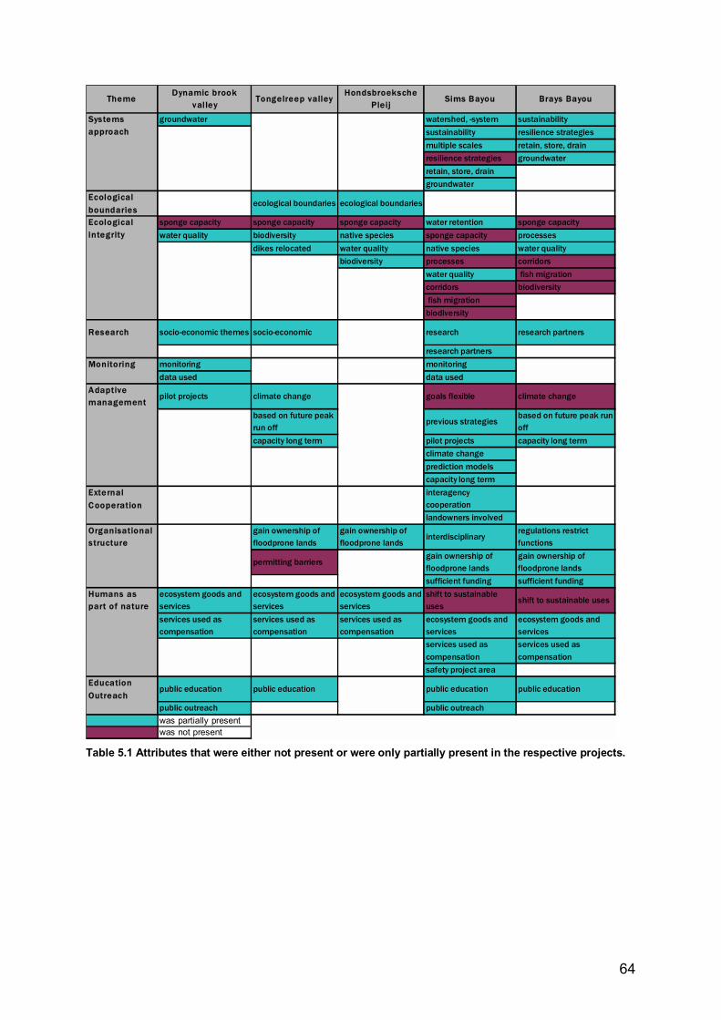
64
ThemeDynamic brook
valley Tongelreep valley
Hondsbroeksche Pleij
Sims Bayou Brays Bayou
groundwater watershed, -system sustainabilitysustainability resilience strategiesmultiple scales retain, store, drainresilience strategies groundwaterretain, store, draingroundwater
Ecological boundaries
ecological boundaries ecological boundaries
sponge capacity sponge capacity sponge capacity water retention sponge capacitywater quality biodiversity native species sponge capacity processes
dikes relocated water quality native species water qualitybiodiversity processes corridors
water quality fish migrationcorridors biodiversity fish migrationbiodiversity
Research socio-economic themes socio-economic research research partners
research partnersMonitoring monitoring monitoring
data used data usedAdaptive management
pilot projects climate change goals flexible climate change
based on future peak run off
previous strategiesbased on future peak run off
capacity long term pilot projects capacity long termclimate changeprediction modelscapacity long term
External C ooperation
interagency cooperationlandowners involved
Organisational structure
gain ownership of floodprone lands
gain ownership of floodprone lands
interdisciplinaryregulations restrict functions
permitting barriersgain ownership of floodprone lands
gain ownership of floodprone lands
sufficient funding sufficient fundingHumans as part of nature
ecosystem goods and services
ecosystem goods and services
ecosystem goods and services
shift to sustainable uses
shift to sustainable uses
services used as compensation
services used as compensation
services used as compensation
ecosystem goods and services
ecosystem goods and services
services used as compensation
services used as compensation
safety project areaEducation Outreach
public education public education public education public education
public outreach public outreachwas partially presentwas not present
Systems approach
Ecological integrity
Table 5.1 Attributes that were either not present or were only partially present in the respective projects.
65
Chapter 6 Discussion of results and methods
6.1 Discussion of the case study results
6.1.1 Total score within framework Due to the limited number and the differences in case study areas the cases can not be considered representative. The overall scores, from section 5.2.1, do however, show clear differences between these cases and are useful because they show the degree to which sustainable floodplain management principles are present in the plans which in turn reflect to what degree these principles are being used in practice. These scores will be seen as valid in showing this relationship in these cases. The percentages shown, cannot however be seen as absolute due to the non-numerical nature of the data. The higher percentage for the Brays Bayou case compared to the Sims Bayou case indicates an improvement in the use of sustainable floodplain management strategies in Houston. This can be seen as a valid result because the two cases are overall highly compareable. The main difference is that in the Sims Bayou case the USACE is the lead party and in the Brays Bayou case the HCFCD is the lead party. This will be seen as an indication that the �old� USACE methods are being improved upon by �new� HCFCD methods.
6.1.2 Comparison of the Dutch cases with the Houston cases As can be clearly seen in figure 5.2 and 5.3 (section 5.2.2) there are obvious differences between the scores for the Dutch cases and those for the Houston cases. The clear result of a greater percentage of sustainable floodplain management strategies being put into practice in the Dutch cases than in the Houston cases will be seen as valid. Again the percentages shown, cannot however be seen as absolute due to the non-numerical nature of the data.
6.1.3 Score per ecosystem management theme The validity of these findings will be discussed per case. Dynamic Brook valley: There is no evidence that the high score for this case in all the themes is not warranted. The absence of using the sponge capacity in soil can be accounted for in the case, but also in the subjective nature of the question. This attribute was absent in all cases and therefore warrants further discussion in the methods section. Tongelreep: Here again there is no evidence that the high score is not warranted. The problems concerning permitting barriers were acknowledged by the project manager and can serve as a lesson to others. Hondsbroeksche Pleij: High scores here are also warranted and will be seen as valid. Sims Bayou: The low scores for this case must be qualified somewhat. These were expected due to the age and history of the plans. The data also lacks additional information from the project manager interview that was present in all the other cases. It is likely that this would have led to a slightly higher score. Nevertheless, evidence from the Brays case can also be applied here and thus there is no evidence to refute the partial presence or complete
66
absence of a number of sustainable floodplain management attributes. Therefore results showing Sims Bayou as the lowest scoring case will be seen as valid. Brays Bayou: Here there is no evidence that would suggest that the Brays score is invalid. It will therefore be seen as higher than Sims Bayou and lower than the Dutch cases.
6.1.4 Score per ecosystem management attribute The relationships found when comparing the results per case and per attribute are shown in table 5.2. The relevant relationships that will be viewed as valid are: - that the Houston cases score poorly for a systems approach when seen in the light of
results for the use of goals for sustainability, the use of resilience strategies, the use of �retain, store and then drain� strategies and the integration of groundwater and surface water management.
- that the ecological integrity goal is only partially present in 80% of the plans. - that the Houston cases do not using climate change as a factor in its models was
confirmed by the project manager and can therefore be seen as valid. The result of meeting long-term capacity was seen as subjective in use and will not be seen as valid.
- that both the Houston cases show the policies of the buyout of flood prone lands and funding as weaknesses.
- and that the use of ecosystem goods and services and public education score are only partially present in most plans.
6.2 Discussion of the framework
6.2.1 Overall use of the framework Working with the framework was seen as useful in categorising essential information. The information gained from project plans and project managers did reveal many weak spots with respect to what could be done differently in project planning or what works or doesn�t in certain situations. In the practical use of the framework several modifications were necessary. Attribute number [10] �Is there a monetary value given to ecosystem services?� is a good example. When using the descriptions for attributes from Hale it seemed logical to use the monetary value of ecosystem services in the ecological integrity theme. The investigator�s thoughts being, �if ecosystem services are worth a dollar/euro value then keeping their ecological integrity is �worth� something�. But the only evidence of the use of a value for ecosystem services was related to property buyouts or compensation for inundated land. This and the fact that the two questions were always answered with the same data made it appropriate to put this attribute under Humans as part of nature. Also, the score would not be counted twice. This indicates that the attribute can be dropped from the framework.
67
The choice to convert data from :
++ = yes + = partially n/a = n/a 0 = no
to:
++ = 2 + = 1 n/a = 0 0 = -1
was made with the knowledge that it would produce more obvious differences in the cases (than perhaps the use of a 0 for the 0 for example) as represented in the graphs. This treatment of data only served to show the difference in cases. This conversion was negated by the final manipulation of the data. While looking at the data to find areas for improvement these subtleties in differences resurfaced. Answering attribute [31] �Which prediction models were used?� would have required another set of documents for all of the cases. This was considered infeasible within the given time. The alternative was to ask the project managers directly which did provide enough information (mainly hydraulic and hydrologic modelling) for this study. It would have been interesting to know more details, such as were any comparable to the layer approach? Or were any models part of an information decision support system using Geographical Information Systems (GIS) tools? These questions could be added to future frameworks. Another modification was the addition of [41a] �Is sufficient funding expected?� late in the development of the framework. This attribute seemed important only after a closer look at the process of funding for the projects. Limited funding seemed to be an issue especially in the U.S. projects. The attribute was added to see if this was a measurable difference in the cases and as shown in the results it was. Here below some comments concerning a few of the ecosystem management themes and attributes: Systems approach Two things that were perceived as lacking in the plans were the integration of stormwater management with surface and groundwater management and the related use of green strategies, such as green roofs or local infiltration systems in cities for the capture of rainwater runoff. This was noticed too late in the study to be added as a specific attribute, but could have been a valuable addition under the systems approach in the framework. Also, all plans used a watershed system as a plan area and in that sense used a systems approach. But this broad attribute fails to show if improvements should be made in the strategy. In Houston, for example, it seems clear that not only a much more integrated approach is necessary but the use of more regional scale would bring many aspects into the plan that are now not included. Ecological Boundaries The ecological boundaries attributes did not fit well into the urban floodplain situation. All plan areas were part of sub-watersheds of larger watersheds and basins. It becomes very difficult in the urban context to know what a realistic ecological boundary would be. Ecological integrity Sponge capacity in soil scored negative in all cases. As such it indicated two things. First, that the use of sponge capacity in soil is not a real option in some areas. And second that its use in the framework should be re-evaluated. A comment from Dr. Hale is useful here: �you may want to define "water retention in nature" better, as some might argue the sponge capacity of soils is part of that.� This should be considered in future use of the framework. Relating this to the water supply and subsidence
68
problems in many urban areas (including The Netherlands and Houston) an important question one could ask is: �If sponge capacity cannot be used in one area, should it be mitigated in another area?� Adaptive management Dr. Hale had some valuable comments in this category such as: should you �broaden this goal to include general uncertainty? Climate change is certain[ly] a big factor, but could there be others?� and �Are the models periodically reassessed, do they incorporate new data and knowledge?� Definitely worth adding to a revised framework, but in the opinion of the investigator climate change should remain an individual attribute.
6.2.2 Usefulness in project plans and evaluations One could argue that the degree of urbanisation in each case affected the outcomes in the data. But since this study was also interested in the lessons or strategies that one situation could teach or learn from another this contrast proved to be valuable. One weakness of the framework lies in the subjective nature of scoring. When asking if sponge capacity in soil is used, for example, it is difficult to know whether to score an (n/a) when the plan specifically excludes such a measure based on local conditions or a (0) because it is absent. In other words should scores be consistent in their insistence of the presence of an attribute in a plan even when it clearly is not feasible. This question will have to be resolved for future use of the framework. Overall the framework proved useful and provided valuable insight into planning strategies. In retrospect, the differentiation of urban floodplains seems unnecessary. A comment by Dr. Ostrowski is also useful here, �Your solution is uncommon, as it differentiates between urban and rural projects beforehand. Integrated manag[e]ment should be basinwide and look at the two types in closer context. Obviously, to avoid a mixed evaluation scheme, you use spatially oriented differences, i.e. urban areas stand for economic value, while rural areas are closer to ecology��
6.3 What did the experts say about the framework? Two experts, as seen above, were asked to comment on the framework. Requested early in the project, but not sent until nearly the end, these comments are found in Appendix 8. Due to their late arrival, they were not used to modify the framework as planned, but are none the less valuable for future research with the framework. Including the comments above, Dr. Brack Hale, who designed the original framework said, �In general, it looks pretty good�. He also made many suggestions for properly defining attributes. Dr. Ostrowski is involved in the Nofdp project and is a professor of Engineering, Hydrology and Water Resources Engineering at the Technical University in Darmstadt, Germany. He said, �In general I find your framework acceptable�. One of his questions was: �Adequate decision making processes have been a deficit in Nofdp. Is this reflected in the framework?� And as above, �Distinction between urban and other areas is not pure in the context of integrated water management.� Again, this distinction was also not found to be necessary in the context of this project. Really, as Dr. Ostrowski says, the same principles apply, the management tools can sometimes differ.
69
Chapter 7 Conclusions and recommendations
7.1 Conclusions of the case study research Below is a list of the conclusions made based on the results of this research project using the ecosystem management framework adapted for sustainable floodplain management. » Dutch cases use a significantly higher percentage of sustainable floodplain management
strategies than Houston cases both on an individual and on an average basis. » The Brays Bayou case showed that significant improvements have been made in the use
of sustainable floodplain management strategies since the planning of the Sims Bayou case. This indicates a difference, also, in the strategies used then (1982, 1993) by the USACE and those used now (2000, 2006) by the HCFCD.
» The Houston cases use a significantly lower percentage of the systems approach attributes than the Dutch cases such as: goals for sustainability, the use of resilience strategies, the use of the �retain, store and then drain� principle and the integration of groundwater in planning flood control projects.
» The ecological integrity goal of improving water quality could be improved in both Houston cases and in the Dynamic brook valley and Hondsbroeksche Pleij cases.
» The adaptive management attribute of using climate change in modelling was absent in both Houston cases.
» The organisational structure attributes to gain ownership of flood prone lands and sufficient funding are seen as weaknesses in both Houston cases.
» The humans as part of nature attributes of using ecosystem goods and services in planning or as compensation for land use change could be improved in all cases.
» The education and outreach attribute of public education could be improved in all cases except the Hondsbroeksche Pleij.
7.2 Conclusions of the methods and framework Here below is a list of the conclusions based on the use and evaluation of the ecosystem management framework adapted for sustainable floodplain management. » The developed framework proved useful and provided valuable insight into differences in
floodplain management planning strategies involved in urban flood control projects. » The integration of stormwater management with surface and groundwater management
should be made an explicit attribute in the framework under systems approach. » Attribute number [10] �Is there a monetary value given to ecosystem services?� can be
dropped from the framework. » The ecological boundaries attributes should be either be left out or defined by other
attributes for use in the urban floodplain situation. » Attribute [41a] �Is sufficient funding expected?� should remain in the framework. » The use of green strategies, such as green roofs or local infiltration systems in cities for
the capture of rainwater runoff should be added as an attribute when evaluating urban plans.
» Under adaptive management, the addition of a �goal to include general uncertainty� as Dr. Hale suggests, is a valuable addition.
» Dr. Ostrowski�s suggestion that �Adequate decision making processes� be added to the framework is recommended. And in this respect the addition of the use of an IDSS
70
[Integrated decision support system] such as is being developed within the Nofdp, as an attribute could be useful.
» And, the distinction between urban and other areas need not be used.
7.3 Answering the main research question Was the framework the right method to answer the main research question? In a black and white way, one could argue that since the question was:
Which floodplain management strategies should be used in urban areas to prevent damage due to flooding while also improving the sustainable use of floodplains?
and since the since the cases are not representative, then, no, the question could not be answered using the methods in this study. The question that could be, and in the opinion of the investigator has been answered is:
Which floodplain management strategies are missing in some urban areas that can prevent damage due to flooding while also improving the sustainable use of floodplains?
In this light, the framework has provided a valid structure to examine weaknesses in the planning of flood control projects with respect to the use of sustainable floodplain management strategies within an ecosystem management framework. The differentiation of urban areas is, in the end, seen as unnecessary. The answer, then, to this second question is that » the systems approach attributes: goals for sustainability, the use of resilience strategies,
the use of the �retain, store and then drain� principle and the integration of stormwater, groundwater and surface water in planning flood control projects are missing in the Houston projects.
» ecological integrity goals such as improving water quality and the adaptive management attribute of using climate change could be added to the planning strategies of all cases.
» the further improvement of gaining ownership of flood prone lands and the guarantee of sufficient funding are seen as weaknesses in the Houston cases.
» the humans as part of nature attributes of using ecosystem goods and services in planning or as compensation for land use change could be improved in all cases.
» the education and outreach attribute of public education could be improved in all cases (except the Hondsbroeksche Pleij).
7.4 Recommendations for further research with the framework » In answering attribute [31] �Which prediction models were used?� it would have been
interesting to know more details, such as were any comparable to the layer approach? Or were any models part of an information decision support system using Geographical Information Systems (GIS) tools? These questions could be added to future frameworks.
» One weakness of the framework lies in the subjective nature of scoring. It is difficult to know whether to score an (n/a) when the plan specifically excludes an attribute based on local conditions or a (0) because it is absent. In other words should scores be consistent in their insistence on the presence of an attribute in a plan even when it clearly is not feasible. This question will have to be resolved for future use of the framework.
71
» The ecological integrity attribute, the use of sponge capacity in soil, must be better defined. Also its necessity in the framework should be questioned within the context of the research question being asked.
7.5 Recommendations for urban floodplain managers What should urban (and other) floodplain managers do based on this research study? The Dutch water managers should: » be encouraged to continue on their course of implementing sustainable floodplain
management strategies. Lessons should be learned and communicated to the province and municipality level that reconstruction plans are not yet recognized as overriding zoning plans and this error should be corrected.
» continue in their search for workable solutions to using the value of ecosystem services (green and blue services in Dutch) to compensate and pay for projects.
» explore the use of sponge capacity in soil, in the context of subsidence and soil drought, to see if it warrants mitigation in other areas.
Harris County Flood Control District and the U.S. Army Corps of Engineers at the Galveston District should also be encouraged by the improvement seen in the planning strategies. They should also do the same that is recommended above as well as: » immediately explore the use of the systems approach as it can provide valuable additions
to the current strategies for both Sims and Brays Bayous. This should be seen in the context of events like Tropical Storm Allison. Broadening the meaning of sustainability in planning to not just numbers of years but to the added resilience of the system to deal with such events means also integrating the surface water management with ground and stormwater management. Another valuable addition to strategies would be investigating the value of urban stormwater strategies, such as the use of green roofs, or local infiltration systems such as are now used at the Texas Medical Center (Skidmore et al, 2005).
» not exclude the improvement of ecological integrity (such as water quality and the use of sponge capacity in soil) of the Bayous. Subsidence is a costly problem in Texas and the water quality running off the bayous is directly affecting the water quality of Galveston Bay and ultimately the Gulf of Mexico.
» Explore the possibility of a monetary value given to the services the bayou�s provide. If this had been calculated, for example, into the benefit/cost analysis of the Channel Diversion alternative in the Sims Bayou plan from 1982, at a cost of 500 million dollars, the benefit/cost ratio would have changed. While not presuming to know if the channel would have made a significant difference in the Tropical Storm Allison scenario, if it had reduced the damage by half (2.5 billion dollars), then in retrospect it was not a too costly option.
» educate the public to the need and the benefit of solving this problem long term and that it has a price, but the price is worth paying. This in the light of the difficulties already experienced in public opposition to such far reaching, long term plans.
» And last but not least, entertain the idea that approaching such issues from a less economic perspective (benefit/cost at all costs) by using the ecosystem management method with the urban area as part of the ecosystem and see what kind of options open up.
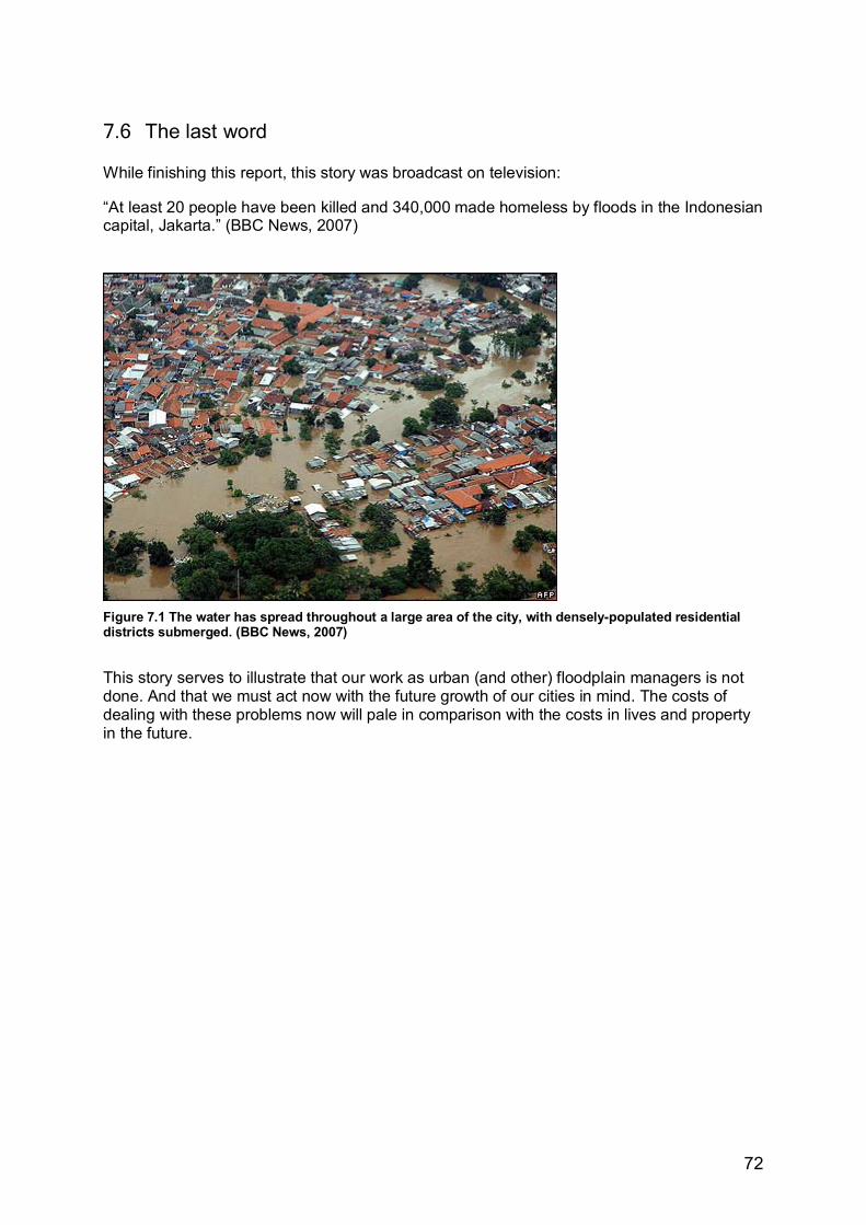
72
7.6 The last word While finishing this report, this story was broadcast on television: �At least 20 people have been killed and 340,000 made homeless by floods in the Indonesian capital, Jakarta.� (BBC News, 2007)
Figure 7.1 The water has spread throughout a large area of the city, with densely-populated residential districts submerged. (BBC News, 2007)
This story serves to illustrate that our work as urban (and other) floodplain managers is not done. And that we must act now with the future growth of our cities in mind. The costs of dealing with these problems now will pale in comparison with the costs in lives and property in the future.
73
Literature Literature cited Alberts, Frank. 2006. Learning from Red Deltas. College Saxion 29 November, 2006. RIZA,
Rijkswaterstaat. 2006. ASFPM Foundation. 2004. NAI Community Case studies. Published by Association of state
floodplain managers. Madison, WI. Obtained at www.floods.org/foundation 20 august 2006. Brouwer, Roy and Remco van Ek. 2004. Integrated ecological, economic and social impact
assessment of alternative flood control policies in the Netherlands. Ecological Economics 2004 Vol. 50, p. 1-21. Elsevier.
Bruijn, Theo de. 2004. Lectorale Rede: Samen werken aan duurzame ontwikkeling (Lector�s
chair:Working toegether on sustainable development). Deventer: Saxion Hogescholen. Brundtland Commission. 1987. Our Common Future, Report of the world Commission on
Environment and Development, New York: Oxford University Press. Burby, R. et al. 1999. Unleashing the power of Planning to Create Disaster-Resistant Communitie�.
Journal of the American Planning Association vol. 65, issue 3. APA: Washington, DC. CW21. 2000. Commissie Waterbeheer 21ste eeuw. Waterbeleid voor de 21ste eeuw (Water Policy for
the 21st Century). Ministry of Transport and Public Works/ Union of Waterboards, Den Haag. Dekker, P.W. 2006. Symposium Bouwen in de uiterwaarden (Building in the River Forelands):
Minister Dekker�s speaking points. Obtained from http://www.vrom.nl/pagina.html?id=23381 27 October 2006. VROM (Ministry of Housing, Spatial Planning and Environment), Den Haag: 2006.
Dickey, Marilyn. 1997. Down on the Bayou: A compromise is reached on measures designed to stop
flooding along Sims Bayou in Houston. Landscape Architecture vol. 87 issue 4, pp. 54-59. American Society of Landscape Architects, Harrisburg, PA:
EEA. 2006. European Environmental Agency. Information for improving the environment: Glossary.
Obtained via http://glossary.eea.europa.eu/EEAGlossary/ 30 October 2006. ESA. 2000. Ecological Society of America. Ecosystem services brochure. Washington, D.C. Obtained
from http://www.esa.org 28 October, 2006. European Parliament. 2000. EU Water Framework Directive. European Community Framework
2000/60/EC from the Eurpoean Parliament from 23 oktober 2000. Obtained from http://europa.eu.int/eur-lex/nl/consleg/pdf/2000/nl_2000L0060_do_001.pdf op 1 March 2005.
E.U. Environment Commission. 2006. Proposal for a DIRECTIVE OF THE EUROPEAN
PARLIAMENT AND OF THE COUNCIL on the assessment and management of floods {SEC(2006) 66}. Obtained from http://ec.europa.eu/environment/water/flood_risk/consult.htm 27 October 2006.
E.U. Water Directors. 2003. Best Practices on flood prevention, protection and mitigation. Results
from meetings in Budapest on 30 November and 1 December 2002, and in Bonn on 5/6 February 2003. Prepared by Germany.
74
Galloway, G.E. Jr. 1994 A Blueprint For Change: Sharing The Challenge: Floodplain Management Into The 21st Century. Report of the Interagency Floodplain Management Review Committee,Washington, D.C.
Gemeente Westervoort. 2005. Zoning plan river widening Hondsbroeksche Pleij and forelands.
(Bestemmingsplan Rivierverruiming Hondsbroeksche Pleij en uiterwaarden). Westervoort. Google Earth. 2007. Satellite images from Europa Technologies, Aerodata International Surveys,:
2007. Grontmij. 2006. Final design lay-out: Dynamic Brook Valley (Eindontwerp Inrichtingsplan
Dynamisch Beekdal). Waterschap Aa en Maas: �s-Hertogenbosch, September 2006. Grumbine, R.E. 1994. What is ecosystem management? Conservation Biology, Vol. 8, No. 1, pp. 27-
38. March 1994. Grumbine, R.E. 1997. Reflections on What is ecosystem management? Conservation Biology, Vol. 11,
No. 1, pp. 41-47. February 1997. Hale, Brack W. and Michael S. Adams. 2006. Ecosystem management and the conservation of river---
floodplain systems. Landscape and Urban Planning. In publication Elsevier 2006. HCFDC. 2006. Harris County Flood Control District. Website glossary and project descriptions.
Obtained from http://www.hcfcd.org/glossary.html#F on 27 September 2006. HCDFD. 2000. Brays Bayou Flood Damage Reduction Plan June 2000. Houston, Texas. Khan, Shuhab D. 2005. Urban development and flooding in Houston Texas, inferences from remote
sensing data using neural network technique. Environmental Geology Vol. 45, pp 1120-1127. Springer-Verlag.
Koks, L., A. Rochat and J. Beuseker. 2005. Inrichtingsplan Herinrichting Tongelreepdal nabij de
voormalige viskweekvijvers. (Lay-out Plan reconstruction Tongelreep valley past the former fish hatchery ponds). Oranjewoud, Oosterhout: March 2005.
KNMI. 2006. Het Koninklijk Nederlands Meteorologisch Instituut. Klimaat en klimaatsveranderingen.
Obtained 31 October, 2006 from http://www.knmi.nl/klimaatverandering_en_broeikaseffect/klimaat_en_klimaatverandering/deel_7.html
Larson, Larry and Doug Plasencia. 2001. No Adverse Impact: A New Direction in Floodplain
Management Policy. Natural Hazards Review, vol. 2, Nov. 2001, IAAN. Marchand, M. and F.H. Toornstra. 1986. Ecological guidelines for river basin development. Centrum
voor Milieukunde, Dept. 28, Rijksuniversiteit, Leiden. Naiman, R.J., J.J. Magnuson, D.M. McKnight, J.A. Stanford. 1995. The Freshwater Imperative: A
Research Agenda. Island Press: Washington, D.C.
Newson, Malcolm. 1997. Land, Water and Development: sustainable management of river basin systems, 2nd edition. Routledge: New York and London. (Rights obtained)
NOAA (National Oceanic and Atmospheric Association). 2006.
(http://www.research.noaa.gov/spotlite/archive/spot_gcip.html)
75
NOFDP. 2006. Nature oriented flood damage prevention brochure and project descriptions. Obtained via www.nofdp.net May 2006.
Oosterberg, Willem en Camiel van Drimmelen. 2006. Rode Delta's: overstromingsrisicobeheer in
verstedelijkt gebied- de praktijk in het buitenland. Rijkswaterstaat-RIZA:Ministerie van Verkeer en Waterstaat December 2006.
PBS & J. 2006. Brays Bayou Federal Flood Control Project: Alternative to the diversion separable
element: Draft EA. Prepared for HCFCD and USACE, October 2006. Houston, Texas. Pinter, Nicholas. 2005. Policy Forum: One step forward, two steps back on U.S. Floodplains. Science
vol. 308, Issue 5719, April 8, 2005. AAAS: Washington, DC. Reuss, Martin and Paul K. Walker.1983. Financing Water Resources: A short history. Office of
History, U.S. Army Corp of Engineers: Washington, D.C. Roorda, N. 2001. AISHE (Auditing Instument for Sustainability in Higher Rducation. CDHO
(Commissie Duurzaam Hoger Onderwijs): Amsterdam. RWS (Rijkswaterstaat). 2006. National Bureau for Room for the River. Obtained from
http://www.ruimtevoorderivier.nl/ 8 October 2006.
RWS Oost-Nederland. 2004a. Project plan/ Environmental Impact Assessment River widening by dike repositioning Hondsbroeksche Pleij: Main Report (Projectnota/MER Rivierverruiming door dijkverlegging Hondsbroeksche Pleij: Hoofdrapport). Arnhem: February 2004.
RWS Oost-Nederland. 2004b. Landschapsplan Hondsbroeksche Pleij. Arnhem: February 2004. RWS Oost-Nederland. 2003. Sustainable Development of Floodplains (SDF) brochure. Arnhem: 2003. Skidmore, Owings & Merrill LLP. 2005. Texas Medical Center: Stormwater Management Design
Guidelines: For the Member Institutions of theTexas Medical Center, Houston,Texas. Obtained via http://www.tmc.edu/masterplan/stormwater/STORMWATER-Master-Plan-2005.pdf .
USACE. 2000a. A National Dialogue About America�s Water Resources Challenges For the 21st
Century: National Report on Identified Water Resources Challenges and Water Challenge Areas. Obtained from http://www.iwr.usace.army.mil/outlook/docs_out/National_Report.pdf 27 Oct. 2006
USACE. 2000b. Civil Works Floodplain Management Initiatives: Value to the Nation. Obtained from http://www.iwr.usace.army.mil/docs/FloodplainManagement.pdf 27 October 2006.. Published by Institute for Water Resources Publications Office:April 2000.
USACE. 1993. Sims Bayou Modified Channel Plan and Environmental Assessment. United States
Army Corps of Engineers, Galveston District. USACE. 1982. Sims Bayou Main Report, Environmental Impact Statement and Appendices. United
States Army Corps of Engineers, Galveston District. United States 109th Congress. 2006. Water Resources Development Act of 2006. Obtained at
http://www.govtrack.us/data/us/bills.text/109/h/h2864.pdf 26 October 2006. V&W. 1996. Ministerie Verkeer en Waterstaat (Ministry of Transport and Public Works), Ruimte
voor de Rivier (Room for the River). Staatscourant 77,9.
76
Villagomez, Rick. 2006. Section 211-Harris County Flood Control District. Project update: US Army Corps of Engineers, Galveston District. Galeveston:2006.
Vis et al. 2003. Resilience strategies for flood risk management in the Netherlands. International
Journal River Basin Management, vol. 1, no. 1, pp. 33-40. IAHR & INBO: 2003. VROM. 2001. Vijfde Nota over de Ruimtelijke Ordening 2000/2020: Ruimte Maken, Ruimte Delen,
Den Haag:2001. VROM, et al. 2006. Startpagina Ruimte x Milieu. Ministerie van VROM, Dauvellier Plan Advies
(Peter Dauvellier), H2Ruimte (Henk Puylaert), Mocean (Ben Koppenens) en TNO (Roelof Westerhof). Verkregen via http://vrom.ruimtexmilieu.nl/frame.php?nID=2 10 januari 2006.
VROM. 2005. Nota Ruimte: Ruimte voor Ontwikkeling. Deel 3A. Sdu Uitgevers, �s-
Gravenhage:2005. Water Board De Dommel. 2001. Water management Plan 2001-2004: Driven by Water.
(Waterbeheersplan 2001-2004: Gedreven door water.) Waterschap De Dommel:Boxtel, Netherlands.
Wescoat, James L. and Gilbert F. White. 2003. Water for life : water management and environmental
policy. Cambridge University Press: 2003. White, Gilbert F. 2000. Water Science and Technology: Some Lessons from the 20th Century.
ENVIRONMENT 2000 Vol. 42 Nr. 1 Pag. 30-38. White, Gilbert F. et al. 1958. Changes in Urban Occupance of Flood Plains in the United States.
University of Chicago Geography Research Papers, No. 57. Chicago: 1958. Wolsink, Maarten. 2006. River basin approach and integrated water management: Governance pitfalls
for the Dutch Space-Water-Adjustment Management Principle. Geoforum 2006 Vol. 37, pp. 473-487. Elsevier: 2006.
Zacharias, I., E. Dimitriou and Th. Koussouris. 2003. Developing sustainable water management
scenarios by using thorough hydrologic analysis and environmental criteria. Journal of Environmental Management, vol. 69, pp, 401-412. Elsevier Ltd.: 2003.
Additional literature Wageningen, Nel van. 2006. Blok 4 Onderzoek (Research Manual). Saxion University: Deventer,
Netherlands. White, Gilbert F. 1998. Reflections on the 50-year international search for integrated water
management. Water Policy 1998 Vol. 1, pp. 21-27. Elsevier Science Ltd.:1998. Yin, Robert. 1993. Case study research: design and methods, 2nd edition. Sage Publications: Thousand
Oaks, CA. Personal communications and interviews Betuw, Marcel van. 2007. Personal communication. Water Board De Dommel. Project manager
Tongelreep valley project. 24 January 2007.
77
Eerden, Henk. 2007. Personal communication Dutch Department of Public Works and Transportation. Project manager Hondsbroeksche Pleij. 24 January 2007.
Farid, Raouf. 2007. Personal communication. Harris County Flood Control District Planning manager
for Brays Bayou Project. 26 January 2007. Hale, Brack Ph.D.. Email communication. Asssitant Professor Biology/Environmental Science,
Franklin College, Sorengo, Switserland. 1 February 2007. Ostrowski, Manfred, Dr. Ing.. Email communication. Technical University, Darmstadt, Germany.
Ingenieurhydrologie und Wasserbewirtschaftung. 23 January 2007. Pastor, Bart. 2007. Personal communication. Water Board Aa and Maas. Project manager for Dynamic
Brook Valley project. 17 January 2007. Rushing, Gene. 2006. Personal communication. Harris County Flood Control District Planning
manager for Sims Bayou Project. 24 October 2006. Internet Sources BBC News. 2007. Jakarta flooding. Obtained February 4, 2007 via
http://news.bbc.co.uk/2/hi/in_pictures/6328977.stm CBS News. 2006. http://www.cbsnews.com/stories/2006/06/20/national/main1732067.shtml Census scope. 2006. U.S. Census 2000. Population growth: Houston, Tx. Obtained from
http://www.censusscope.org/us/m3360/chart_popl.html 9 October 2006. Deltawerken Online. 2006. http://www.deltawerken.com/Copyright-Kleurcodes/449.html DNR. 2006. Definition of Terms in the National Flood Insurance Program Department of Natural
Resources, Lincoln Nebraska. Obtained via www.dnr.state.ne.us/floodplain/flood/Insurance/definitions-NFIP.html 22 January 2007.
Houston Chronicle. 2007.The Great Flood of 2001: Allison�s Legacy. Obtained 3 February 2007 via
http://www.chron.com/content/chronicle/special/01/flood/index.html . NASA. 2006. Floods in Portugal. Natural Hazards, Earth Observatory. Obtained via
http://earthobservatory.nasa.gov/NaturalHazards/natural_hazards_v2.php3?img_id=13947 2 December 2006.
Reuters. 2006. Flash floods sweep southeast Turkey, killing 33. 02 Nov 2006. Obtained via
http://www.alertnet.org/thenews/newsdesk/L02751972.htm 2 December 2006. TSARP. 2007. Tropical Storm Allison Recovery Project. Federal Emergency Management Agency
and Harris County Flood Control District. Obtained via http://www.tsarp.org/tsa_over/index.html 3 Feb. 2007.
78
Appendix 1 Research questions Orientation/exploration Introduction (step 1) 1. What types of research design/methods are there and which one lends itself to the research
question? 1.1. Which research design can be used to compare a real-life subject to a theoretical approach? 1.2. What kind of data is necessary to answer the research question and where can it be found?
1.2.1. Is a case study appropriate? 1.2.2. If so, what criteria can be used to choose a case? 1.2.3. If not, what other options are there? �Flood control projects� as subject for
evaluation/comparison? 1.3. Which research method can be used to explore the published literature of sustainable
floodplain management? 1.4. Which research method can be used to inventory the policies and practices of floodplain
management? Policy overview (step 2) 2. What are the floodplain management policies of the US? of the EU? Netherlands?
2.1. What are the flood damage prevention policies of the US? of the EU? Netherlands? 2.1.1. Who are the relevant actors: who has influence over policy?
3. What are the spatial planning policies of the US? of the EU? Netherlands? 3.1. What is the relationship between floodplain management policy and spatial planning
policies? 3.2. Which development strategies support the implementation of sustainable floodplain policy? 3.3. What are the relevant criteria concerning the relationship between spatial planning policy and
sustainable floodplain management for use in a comparison/evaluation? 3.4. Which criteria should be used to choose a study area for further evaluation?
Sustainable floodplain management (step 3) 4. What is sustainable floodplain management according to scientific literature?
4.1. Can I find definitions on sustainability? 4.2. What do I have to take into account? 4.3. Is it possible to categorize or to prioritise? 4.4. Which policies and measures are considered to have a positive effect on the sustainable
management of floodplains and the prevention of damage due to flooding? 4.5. Which of these policies and measures promote the use of floodplain restoration? 4.6. What is the definition of sustainable floodplain management for this study? 4.7. Which elements/factors of sustainable floodplain management can be used to define criteria
for the evaluation of floodplain management policies and measures for this study? 4.8. Which elements/factors of sustainable floodplain management will be used to evaluate
strategies for the study area? And how? Methods (step 4) 5. What are the goals of the study?
5.1. Compare Dutch, European and American cases on flood protection measures on water management, ecology and spatial planning.
5.2. Which are the best sustainable approaches? 5.3. Can the approach be improved to a more sustainable one?
79
Methods (step 5-6) 6. How can the principles of sustainable floodplain management be used in a framework for the
evaluation of flood control projects? 6.1. Is there an existing framework or will one have to be developed? 6.2. Are there experts to consult for help in using or developing a framework?
Methods (step 7) 7. Are the principles of floodplain management being used in flood control projects?
7.1. What are the criteria for choosing case study projects? 7.2. Describe the current status of the study area. 7.3. What are the relevant policies and instruments used for the implementation of the project? 7.4. What are the factors and actors of special relevance for the study area? 7.5. Are proposed measures considered sustainable? 7.6. Are implemented measures considered sustainable? 7.7. What are the results of the measures implemented?
Results (step 8) 8. What are the results of the comparison of flood control project plans to theory in the framework?
8.1. How do the water management policies used in the plans compare to sustainable floodplain management theory?
8.2. How do the spatial planning policies used in the plans compare to sustainable floodplain management theory?
9. What are the results of the comparison of flood control project managers� practical experience to theory in the framework? 9.1. What are the experiences in the practice of sustainable floodplain management policies?
9.1.1. Sims Bayou, Texas? 9.1.2. Brays Bayou, Texas? 9.1.3. Room for the River project? 9.1.4. NOFDP?
9.2. What are the experiences/results of the measures implemented? 9.2.1. Sims Bayou, Texas? 9.2.2. Brays Bayou, Texas? 9.2.3. Room for the River project? 9.2.4. NOFDP?
10. In what form should the final results be presented? Discussion (step 9) 11. What are the results of the data evaluation in the analysis framework?
11.1. Are sustainable floodplain management principles present? 11.2. Are there key factors missing?
12. How do the flood control project scores compare to each other? 13. How do the scores compare to theory? 14. How do scores compare to current policy? Discussion (step 10-11) 15. What are the relevant results for the improvement of sustainable floodplain management?
15.1. Which results can be used to support recommendations for floodplain managers for the improvement of the prevention of damage due to flooding?
16. What are the relevant experiences of the practical implementations? 16.1. Which lessons/experiences apply to or can be used to improve other situations?
17. What is the applicability of sustainable floodplain management principals for other urbanised floodplains? 17.1. Which policies have the most chance of success and why? 17.2. Which measures have the most chance of success and why?
80
Discussion (step 12) 18. Did the study follow the research plan?
18.1. If not, what did not follow the plan? 18.2. Was the research design adequate? 18.3. If not, what would have improved it? 18.4. Was the analysis framework effective? 18.5. Were the results what you expected? 18.6. Looking back at the research project what would or should you have done differently? 18.7. Are there recommendations for further research? 18.8. Are there warnings to future researchers?
Conclusions and recommendations (step 13) 19. What are the conclusions that can be drawn from an analysis of the study area within a framework
of sustainable floodplain management key factors? 19.1. Which policy decisions have to be made by the water management authorities in order
to make use of these key factors? 19.2. Which existing instruments can be of use or are new instruments needed?
20. Is the developed framework useful in project evaluation? 21. Which recommendations can be made for the improved use of applicable sustainable
floodplain management principles in flood control project planning to prevent damage due to flooding in urban areas? And to whom should recommendations be made? 21.1. To whom should these recommendations be made?
81
Appendix 2 Abbreviations
CW21 Dutch Commission for Water Management for the 21st century FEMA Federal Emergency Management Agency HCFCD Harris County Flood Control District NED National Economic Development NFIP National flood insurance program NOFDP Nature oriented flood damage prevention RvR Ruimte voor de Rivier (Room for the River) RWS Rijkswaterstaat (Dutch Department of Public works and Transportation) USACE United States Army Corps of Engineers
82
Appendix 3 Research process flow chart
Figure A3.1 Research process flow chart
Research design:Literature search
Research questions and goals Research plan
Research plan
Sustainable floodplain management theory
Floodplain management policy
Floodplain management practice
Criteria for choosing projects for case studies
Ecosystem management framework (Hale)
+ Urban floodplains
Project plan 2Project plan 1
Theory
Research design evaluation
Pract ice
Compare results to - framework (theory) - each other - policy
Report with discussion and recommendations: - Are themes used in policy reflected in planning? - If not, why not= - What are significant differences in results? What works?
What doesn�t? - Which sustainable floodplain management strategies can we
use to improve floodplain management in urban areas? - Is the developed framework useful in project evaluation?
Check framework validity with experts (Hale, Ostrowski)
Analysis of project documents (cases)
Project plan 3
Themes from policy(layer approach, water
test) +
lessons learned from practical implementation
Analysis framework =Sustainable floodplain management + urban flood damage prevention
Project plan 4
Project manager 1 Project manager 2 Project manager 3 Project manager 4
Framework based interview:
83
Appendix 4 External contacts/organisations External sponsor
Piet van Iersel Water Board Brabantse Delta, Ulvenhout, Netherlands Netherlands nofdp project coördinator Telephone 076 564 1511
Project contacts (manager interviewed) Planning documents analysed Case A Bart Pastor Project manager Dynamic brook valley: River Aa (Nature-oriented flood damage prevention (Nofdp) project) Water Board Aa and Maas, Den Bosch, Netherlands 073 615 6798 [email protected]
- Final design lay-out: Dynamic Brook Valley (Grontmij, 2006)
- Nofdp project documents (Nofdp, 2006)
Case B Marcel van Betuw Project manager Tongelreep Valley Reconstruction (Nofdp) Water Board De Dommel, Boxtel, Netherlands 0411 618 423 [email protected]
- Lay-out Plan reconstruction Tongelreep valley past the former fish hatchery ponds (Koks et al, 2005)
- Nofdp project documents (Nofdp, 2006) - Water management plan (Water Board De
Dommel, 2001) Case C Henk Eerden Project manager: Hondsbroeksche Pleij Rijkswaterstaat-Oost, Arnhem, Netherlands Sustainable Development of Floodplains (SDF)/Room for the River Project Telephone (0031) (0)26-368 8118 Mobiel (0031) (0)6-5370 0865 [email protected]
- Landscape plan Hondsbroeksche Pleij (RWS Oost, 2004b)
- Zoning plan River widening Hondsbroeksche Pleij and River forelands (Gemeente Westervoort, 2005)
- Projectnota/MER River widening through dike relocation Hondbroeksche Pleij: Main report (RWS Oost, 2004a)
- Sustainable Development of Floodplains (SDF) brochure (RWS Oost, 2003)
Case D Gene Rushing Planning manager Sims Bayou Project Harris County Flood Control District, Houston, Texas, US 1 713 684 4080 [email protected]
- Sims Bayou Main Report, EIS and Appendices (USACE, 1982)
- Sims Bayou Modified Channel Plan and EA (USACE, 1993)
Case E Raouf Farid Project manager Brays Bayou Harris County Flood Control District, Houston, Texas, US [email protected]
- Brays Bayou Flood Damage Reduction Plan (HCDFD, 2000)
- Brays Bayou Federal Flood Control Project: Alternative to the diversion separable element: Draft EA (PBS&J, 2006)
Tabel A4.1 Data sources: project planning documents and project managers
Consulted on framework theory
Brack Hale, Ph.D. Assistant Professor Biology/Environmental Science Franklin College Switzerland, Sorengo Switserland Tel. +41 91 986 3650 [email protected]
Prof. Dr.-Ing. Manfred Ostrowski, Engineering Hydrology and Water Resources Engineering Technical University Darmstadt Germany [email protected]
84
Appendix 5 Ecosystem management framework
Figure A5.1 (part 1) Ecosystem management framework and ratings for each reserve. (Hale and Adams, 2006)
85
Figure A5.1 (part 2) Ecosystem management framework and ratings for each reserve. (Hale and Adams, 2006)

86

87
Appendix 6 Data collection tables
Appendix 6. A. Project: Dynamisch Beekdal Aa Appendix 6. B. Project: Tongelreep Valley Appendix 6. C. Project: Hondsbroeksche Pleij Appendix 6. D. Project: Sims Bayou Appendix 6. E. Project: Brays Bayou

88
89
Appe
ndix
6.A
. Dat
a co
llect
ion
tabl
e: D
ynam
ic v
alle
y: A
a
Them
e At
tribu
tesc
ore
sear
ch te
rms
1. D
o pl
ans
use
a w
ater
shed
, -sy
stem
app
roac
h?++
EI p
. vii
"duu
rzaa
m w
ater
syst
eem
", p.
2 "
natu
urlij
k w
ater
syst
eem
"
2. D
o go
als
focu
s on
long
term
sus
tain
abili
ty?
++EI
p. v
ii 2
050
,3.
Are
mul
tiple
sca
les
used
?++
EI p
. vii
inte
gral
e: lo
kaal
, wat
ersc
hap,
gem
eent
e, p
rovi
ncie
4. A
re re
silie
nce
stra
tegi
es u
sed?
(Is
ther
e an
att
empt
to u
se n
atur
al p
roce
sses
to
pre
vent
dam
age
due
to fl
oodi
ng?)
++EI
p. v
ii na
tuur
lijke
dyn
amie
k va
n Aa
-dal
wor
dt v
ergr
oot,
p. 3
3
veer
krac
ht v
an h
et w
ater
syst
eem
wor
dt v
ergr
oot,
mea
nder
x 14
0
5. Is
reta
in, s
tore
and
then
dra
in u
sed?
++EI
p. v
ii en
p. i
x vas
thou
den-
berg
en-a
fvoe
ren
6. Is
the
prin
cipl
e of
no
adve
rse
impa
ct (u
p- a
nd d
owns
tream
) use
d?++
EI p
. vii
niet
afw
ente
len
7. Is
gro
undw
ater
man
agem
ent l
inke
d to
sur
face
wat
er m
anag
emen
t?+
EI p
. 12
ben
eden
stro
oms
wor
dt v
eel n
atte
r en
onge
schi
kt v
oor
regu
liere
land
bouw
; BP
gro
ndw
ater
krij
gt v
eel a
anda
cht i
n pl
an
maa
r mon
itorin
g is
gro
fmaz
ig e
n be
perk
t8.
Are
eco
logi
cal b
ound
arie
s us
ed?
++EI
p. 1
pla
ngeb
ied
is b
eekd
al, p
.17
"een
beg
in w
ordt
gem
aakt
m
et h
et h
erst
el v
an d
e la
ndsc
haps
ecol
ogis
che
verb
indi
ng m
et h
et ri
vier
ecos
yste
em"
9. D
o bo
unda
ries
exte
nd a
cros
s po
litic
al b
ound
arie
s?++
wat
ersc
hap,
mee
rder
e ge
mee
ntes
, mee
dere
pro
vinc
ies,
rijk
10. I
s th
ere
a m
onet
ary
valu
e gi
ven
to e
cosy
stem
ser
vice
s?n/
azie
45
en 4
6
11. I
s th
e us
e of
wat
er re
tent
ion
in n
atur
e st
imul
ated
?++
EI p
. vii
wat
erbe
rgin
g is
een
doe
lste
ling,
p. v
iii 1
7% re
duct
ie
piek
afvo
er e
n 3.
3 m
ilioe
n m
3 b
ergi
ng12
. Is
the
use
of s
pong
e ca
paci
ty o
f soi
l stim
ulat
ed?
0EI
p. 1
9, v
erna
tting
is n
iet a
ltijd
real
isee
rbaa
r of g
ewen
st in
pla
n om
dat h
et le
idt t
ot h
oger
e gr
ondw
ater
pei
len
in la
ndbo
uw
gebi
eden
, p. 2
1 ni
et g
ewen
st iv
m d
ynam
iek
13. A
re th
ere
goal
s to
mai
ntai
n/re
stor
e na
tive
spec
ies/
com
mun
ities
and
va
riatio
ns?
++EI
p. 2
stre
efso
orte
n
14. A
re th
ere
goal
s to
mai
ntai
n ec
olog
ical
and
evo
lutio
nary
pro
cess
es: n
utrie
nt
cycl
ing,
reco
gnize
role
of n
atur
al d
istu
rban
ce (e
.g. f
lood
s)?
++EI
p. 1
9 in
unda
tie le
idt t
ot h
oger
e gr
ondw
ater
pei
len
en
�bi
jzon
dere
soo
rten
15. W
ill w
ater
qua
lity b
e im
prov
ed?
+EI
p. 1
4 v
erbe
terin
g va
n ec
olog
isch
e w
ater
kwal
iteit
wor
dt w
el
verw
acht
maa
r mee
tbar
e ve
rbet
erin
g w
ordt
nie
t ver
wac
ht iv
m
bove
nstro
oms
fact
oren
16. A
re g
oals
rela
ted
to e
colo
gica
l cor
ridor
s?++
EI s
ee 8
, ver
bind
ing
x 32
17. I
s fis
h m
igra
tion
impr
oved
?++
EI p
. 4 g
ehee
l tra
ject
is v
ispa
seer
baar
18. A
re th
ere
goal
s fo
r the
impr
ovem
ent o
f bio
dive
rsity
?++
EI p
. 18
vis
soor
ten,
p. 1
9 so
orte
n rij
ke s
chra
alla
nden
19. W
ill le
vees
/dik
es b
e re
loca
ted?
++EI
p. v
iii k
ades
lang
sd d
e Aa
wor
den
grot
ende
els
verw
ijder
d
Systems approachEcological
boundariesEcological integrity
Ta
ble
A6.
A. (
part
1)
++ =
attr
ibut
e is
pre
sent
; +
= p
artia
lly p
rese
nt o
r in
deve
lopm
ent;
0 =
not
pre
sent
; n/a
= n
ot a
pplic
able
Sour
ces
= Pl
an: F
inal
Des
ign
lay-
out D
ynam
ic V
alle
y(EI
); In
terv
iew
Bar
t Pas
tor (
BP)
90
Them
e At
tribu
tesc
ore
sear
ch te
rms
20. I
s th
ere
an a
ctiv
e re
sear
ch p
rogr
am?
++EI
p. 3
0 Ri
za d
oet o
nder
zoek
, p. 5
5 ar
cheo
logi
sche
ond
erzo
ek, p
. 59
hyd
rolo
gisc
he o
nder
zoek
21. A
re s
ocio
-eco
nom
ic th
emes
con
side
red?
+
EI B
ijlag
e 9
plan
is b
eper
kt v
anw
ege
vele
eco
nom
isch
e fu
nctie
s in
het
geb
ied,
p. 3
1 ka
nsen
voo
r lan
dbou
w22
. Doe
s it
seek
out
/use
rese
arch
par
tner
s?++
RIZA
, Gro
ntm
ij, e
tc
23. D
oes
a m
onito
ring
syst
em e
xist?
+
EI n
iet g
evon
den;
BP
maa
kt e
en v
ersc
hil t
usse
n be
leid
sdoe
l m
onito
ring
en e
ffect
en m
onito
ring.
Voo
r bel
eids
doel
en zi
jn n
u de
nu
l situ
atie
gem
eten
, voo
r effe
cten
ook
, vra
ag is
of d
at o
ok w
eer
geto
ets
wor
dt, w
el in
rout
inem
atig
e m
onito
ring
van
wat
ersc
hap
en b
ehee
rder
s
24. A
re th
e da
ta p
erio
dica
lly a
nalyz
ed?
+zie
23
25. A
re m
anag
emen
t goa
ls fl
exib
le?
++EI
wel
in d
e zin
van
KRW
en
land
bouw
doe
lein
den;
BP
inric
htin
gspl
anne
n m
oete
n m
et m
aatw
erk
gem
aakt
wor
den
dus
in d
ie zi
n zij
n ze
flex
ible
26
. Do
they
exa
min
e pr
evio
us m
anag
emen
t stra
tegi
es?
++
EI p
. vii
De
beek
die
in h
et v
erle
den
rech
t is
getro
kken
(g
ekan
alis
eerd
), m
et h
et o
og o
p ee
n sn
elle
re a
fvoe
r van
wat
er,
geve
n w
e nu
haa
r oor
spro
nkel
ijke
loop
wee
r ter
ug.
27. A
re m
anag
emen
t act
ions
run
as e
xper
imen
ts (p
ilot p
roje
cts)
?+
hier
nvt
, maa
r wat
ersc
hap
voer
t wel
pilo
ts u
it (W
BP p
. 30,
104
10
5)
28. I
s cl
imat
e ch
ange
con
side
red
a fa
ctor
?++
EI
p. 3
3 D
oor w
ater
mee
r rui
mte
te g
even
wor
dt d
e ve
erkr
acht
va
n he
t wat
ersy
stee
m v
ergr
oot e
n za
l de
Aa b
eter
in s
taat
zijn
to
ekom
stig
e on
twik
kelin
gen
in h
et k
limaa
t op
te v
ange
n.29
. Is
the
wat
er s
tora
ge p
lan
base
d on
futu
re p
eak
run
off e
vent
s?++
EI
p. 6
tabe
l 1.1
30. A
re p
redi
ctio
n m
odel
s ar
e us
ed in
pla
nnin
g?++
EI
p. 7
SOB
EK
31. W
hich
mod
els?
Bas
ed o
n? (F
or u
se in
inte
rvie
w o
nly)
n/a
Sobe
k32
. Is
the
new
(exp
ecte
d) c
apac
ity e
xpec
ted
to m
eet l
ong
term
nee
ds?
++EI
p.1
1 ta
bel 2
.1
33. I
s th
ere
inte
rage
ncy c
oope
ratio
n?++
EI
p. 3
9-40
sam
enw
erki
ng p
rovi
ncie
en
rws
ivm
N27
9 en
ZW
V34
. Are
ther
e m
echa
nism
s to
com
mun
icat
e w
ith lo
cal c
omm
unity
? ++
EI
p.ix
, x v
ersc
hille
nde
com
mun
icat
ie m
idde
len
35. A
re th
e pu
blic
and
loca
l lan
dow
ners
invo
lved
in p
robl
em d
efin
ition
/dec
isio
n m
akin
g?
++
EI p
. ix i
nspr
aak;
BP
sam
enw
erki
ng m
et lo
kale
bel
angh
ebbe
nde
is c
ruci
aal g
ewee
st in
pla
nvor
min
g en
blij
ft cr
ucia
al v
oor
inric
htin
gspl
anne
n en
uitv
oerin
g
External
Cooperation Research Monitoring Adaptive management
Ta
ble
A6.
A. (
part
2)
++ =
attr
ibut
e is
pre
sent
; +
= p
artia
lly p
rese
nt o
r in
deve
lopm
ent;
0 =
not
pre
sent
; n/a
= n
ot a
pplic
able
So
urce
s =
Plan
: Fin
al D
esig
n la
y-ou
t Dyn
amic
Val
ley(
EI);
Inte
rvie
w B
art P
asto
r (B
P)
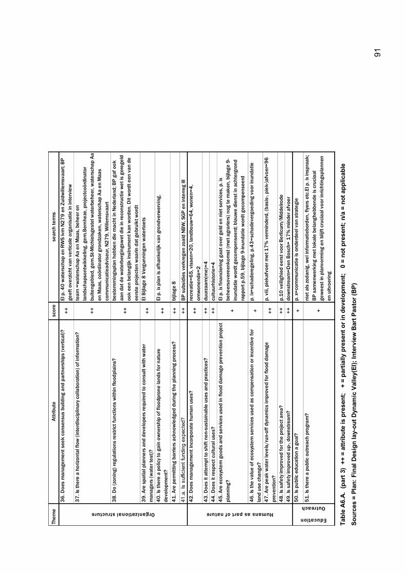
91
Them
e At
tribu
tesc
ore
sear
ch te
rms
36. D
oes
man
agem
ent s
eek
cons
ensu
s bu
ildin
g an
d pa
rtner
ship
s (v
ertic
al)?
++
EI p
. 40
wat
ersc
hap
en R
WS
ivm
N27
9 en
Zui
dwill
emsv
aart;
BP
geef
t ove
rzic
ht v
an v
ertic
ale
orga
nisa
tie in
inte
rvie
w37
. Is
ther
e a
horiz
onta
l flo
w (i
nter
disc
iplin
ary c
olla
bora
tion)
of i
nfor
mat
ion?
++
team
=w
ater
scha
p Aa
en
Maa
s, b
ehee
r en
land
scha
pson
twik
kelin
g, g
em.B
ernh
eze,
pro
ject
coör
dina
tor
buite
ngeb
ied,
gem
.St-M
ichi
elsg
este
l wat
erbe
heer
, wat
ersc
hap
Aa
en M
aas,
coö
rdin
ator
gro
ndza
ken,
wat
ersc
hap
Aa e
n M
aas
com
mun
icat
iead
vise
ur, N
279,
Will
emsv
aart
38. D
o (z
onin
g) re
gula
tions
rest
rict f
unct
ions
with
in fl
oodp
lain
s?
++
best
emm
ings
plan
heb
ben
die
mac
ht in
Ned
erla
nd; B
P ga
f ook
aa
n da
t de
wat
erbe
rgin
gsw
et d
ie in
reco
nstru
ctie
wet
is g
ereg
eld
ook
een
bela
ngijk
inst
rum
ent k
an w
orde
n. D
it w
ordt
een
van
de
eers
te p
roje
cten
waa
rin d
at g
ebru
ikt w
ordt
39. A
re s
patia
l pla
nner
s an
d de
velo
pers
requ
ired
to c
onsu
lt w
ith w
ater
m
anag
ers
(wat
er te
st)?
++EI
Bijl
age
8 Ve
rgun
ning
en w
ater
toet
s
40. I
s th
ere
a po
licy t
o ga
in o
wne
rshi
p of
floo
dpro
ne la
nds
for n
atur
e de
velo
pmen
t?++
EI p
. ix p
lan
is a
fhan
kelij
k va
n gr
ondv
erw
ervi
ng,
41. A
re p
erm
ittin
g ba
rrier
s ac
know
ledg
ed d
urin
g th
e pl
anni
ng p
roce
ss?
++bi
jlage
8
41.a
. Is
suffi
cien
t fun
ding
exp
ecte
d?
++BP
sub
sidi
es v
erkr
egen
zoal
d NB
W, S
GP e
n in
terre
g III
42. D
oes
man
agem
ent i
ncor
pora
te h
uman
use
s?++
recr
eatie
=65,
vis
sen=
20, l
andb
ouw
=64,
won
en=4
, om
won
ende
=243
. Doe
s it
atte
mpt
to s
hift
non-
sust
aina
ble
uses
and
pra
ctic
es?
++du
urza
am(m
e)=4
44. D
oes
it re
spec
t cul
tura
l use
s?
++cu
ltuur
hist
orie
=445
. Are
eco
syst
em g
oods
and
ser
vice
s us
ed in
floo
d da
mag
e pr
even
tion
proj
ect
plan
ning
?+
EI p
. ix f
inan
cier
ing
gaat
ove
r gel
d en
nie
t ser
vice
s, p
. ix
behe
erso
vere
enko
mst
(met
agr
arie
rs) n
og te
mak
en, b
ijlag
e 9-
inun
datie
wor
dt g
ecom
pens
eerd
; bla
uwe
dien
st in
ach
terg
rond
ra
ppor
t p.5
9, b
ijlag
e 9-
inun
datie
wor
dt g
ecom
pens
eerd
46. I
s th
e va
lue
of e
cosy
stem
ser
vice
s us
ed a
s co
mpe
nsat
ion
or in
cent
ive
for
land
use
cha
nge?
+p.
ix=s
chad
ereg
elin
g, p
.43=
scha
deve
rgoe
ding
voo
r inu
ndat
ie
47. A
re p
eak
wat
er le
vels
/run
-off
dyna
mic
s im
prov
ed fo
r flo
od d
amag
e pr
even
tion?
++p.
viii
, pie
kafv
oer m
et 1
7% v
erm
inde
rd, (
basi
s-, p
iek-
)afv
oer=
96
48. I
s sa
fety
impr
oved
for t
he p
roje
ct a
rea?
++p.
10 v
eilig
hied
eer
st v
oor B
erlic
um/M
idde
lrode
49. I
s sa
fety
impr
oved
up-
, dow
nstre
am?
++do
wns
tream
=Den
Bos
ch=
17%
min
der a
fvoe
r50
. Is
publ
ic e
duca
tion
a go
al?
+p.
x=co
mm
unic
atie
is o
nder
deel
van
stra
tegi
e
51. I
s th
ere
a pu
blic
out
reac
h pr
ogra
m?
+
niet
als
zoda
nig,
wel
info
rmat
iebo
rden
, flye
rs e
tc.E
I p. i
x ins
praa
k;
BP s
amen
wer
king
met
loka
le b
elan
gheb
bend
e is
cru
ciaa
l ge
wee
st in
pla
nvor
min
g en
blij
ft cr
ucia
al v
oor i
nric
htin
gspl
anne
n en
uitv
oerin
g
Education
OutreachOrganizational structure Humans as part of nature
Ta
ble
A6.
A. (
part
3)
++ =
attr
ibut
e is
pre
sent
; +
= p
artia
lly p
rese
nt o
r in
deve
lopm
ent;
0 =
not
pre
sent
; n/a
= n
ot a
pplic
able
Sour
ces
= Pl
an: F
inal
Des
ign
lay-
out D
ynam
ic V
alle
y(EI
); In
terv
iew
Bar
t Pas
tor (
BP)
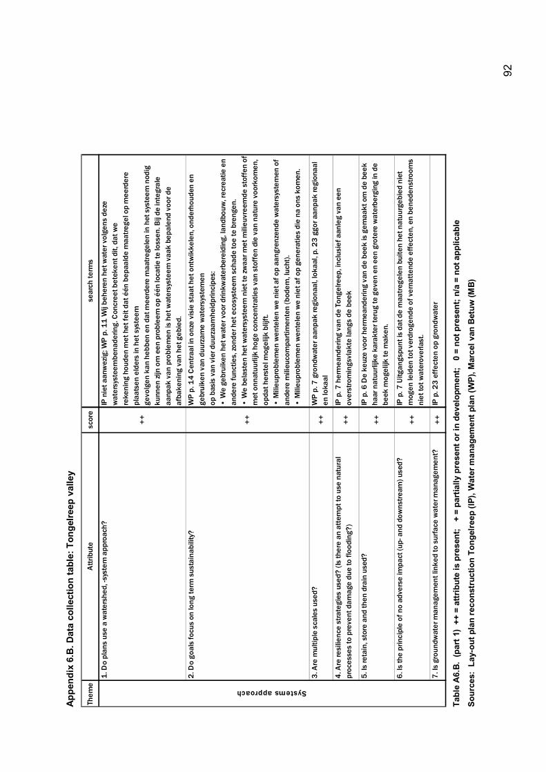
92
Appe
ndix
6.B
. Dat
a co
llect
ion
tabl
e: T
onge
lreep
val
ley
Them
e A
ttrib
ute
scor
ese
arch
term
s
1. D
o pl
ans
use
a w
ater
shed
, -sy
stem
app
roac
h?
++
IP n
iet a
anw
ezig
; WP
p. 1
1 W
ij be
here
n he
t wat
er v
olge
ns d
eze
wat
ersy
stee
mbe
nade
ring.
Con
cree
t bet
eken
t dit,
dat
we
reke
ning
hou
den
met
het
feit
dat é
én b
epaa
lde
maa
trege
l op
mee
rder
e pl
aats
en e
lder
s in
het
sys
teem
gevo
lgen
kan
heb
ben
en d
at m
eerd
ere
maa
treg
elen
in h
et s
yste
em n
odig
ku
nnen
zijn
om
een
pro
blee
m o
p éé
n lo
catie
te lo
ssen
. Bij
de in
tegr
ale
aanp
ak v
an p
robl
emen
is h
et w
ater
syst
eem
vaa
k be
pale
nd v
oor d
e af
bake
ning
van
het
geb
ied.
2. D
o go
als
focu
s on
long
term
sus
tain
abili
ty?
++
WP
p. 1
4 C
entra
al in
onz
e vi
sie
staa
t het
ont
wik
kele
n, o
nder
houd
en e
n ge
brui
ken
van
duur
zam
e w
ater
syst
emen
op b
asis
van
vie
r duu
rzaa
mhe
idpr
inci
pes:
� W
e ge
brui
ken
het w
ater
voo
r drin
kwat
erbe
reid
ing,
land
bouw
, rec
reat
ie e
n an
dere
func
ties,
zond
er h
et e
cosy
stee
m s
chad
e to
e te
bre
ngen
.�
We
bela
sten
het
wat
ersy
stee
m n
iet t
e zw
aar m
et m
ilieu
vree
mde
sto
ffen
of
met
onn
atuu
rlijk
hog
e co
ncen
trat
ies
van
stof
fen
die
van
natu
re v
oork
omen
, op
dat h
erst
el m
ogel
ijk b
lijft.
� M
ilieu
prob
lem
en w
ente
len
we
niet
af o
p aa
ngre
nzen
de w
ater
syst
emen
of
ande
re m
ilieu
com
part
imen
ten
(bod
em, l
ucht
).�
Mili
eupr
oble
men
wen
tele
n w
e ni
et a
f op
gene
ratie
s di
e na
ons
kom
en.
3. A
re m
ultip
le s
cale
s us
ed?
++
WP
p. 7
gro
ndw
ater
aan
pak
regi
onaa
l, lo
kaal
, p. 2
3 gg
or a
anpa
k re
gion
aal
en lo
kaal
4. A
re re
silie
nce
stra
tegi
es u
sed?
(Is
ther
e an
att
empt
to u
se n
atur
al
proc
esse
s to
pre
vent
dam
age
due
to fl
oodi
ng?)
++
IP p
. 7 h
erm
eand
erin
g va
n de
Ton
gelre
ep, i
nclu
sief
aan
leg
van
een
over
stro
min
gsvl
akte
lang
s de
bee
k
5. Is
reta
in, s
tore
and
then
dra
in u
sed?
++
IP p
. 6 D
e ke
uze
voor
her
mea
nder
ing
van
de b
eek
is g
emaa
kt o
m d
e be
ek
haar
nat
uurli
jke
kara
kter
teru
g te
gev
en e
n ee
n gr
oter
e w
ater
berg
ing
in d
e be
ek m
ogel
ijk te
mak
en.
6. Is
the
prin
cipl
e of
no
adve
rse
impa
ct (u
p- a
nd d
owns
trea
m) u
sed?
++
IP p
. 7 U
itgan
gspu
nt is
dat
de
maa
treg
elen
bui
ten
het n
atuu
rgeb
ied
niet
m
ogen
leid
en to
t ver
drog
ende
of v
erna
tten
de e
ffect
en, e
n be
nede
nstro
oms
niet
tot w
ater
over
last
.
7. Is
gro
undw
ater
man
agem
ent l
inke
d to
sur
face
wat
er m
anag
emen
t?+
+IP
p. 2
3 e
ffec
ten
op g
rond
wat
er
Systems approach
Ta
ble
A6.
B. (
part
1)
++ =
attr
ibut
e is
pre
sent
; +
= p
artia
lly p
rese
nt o
r in
deve
lopm
ent;
0 =
not
pre
sent
; n/a
= n
ot a
pplic
able
Sour
ces:
Lay
-out
pla
n re
cons
truc
tion
Tong
elre
ep (I
P), W
ater
man
agem
ent p
lan
(WP)
, Mar
cel v
an B
etuw
(MB)
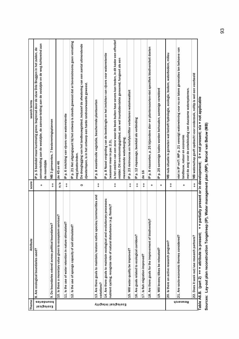
93
Them
e At
tribu
tesc
ore
sear
ch te
rms
8. A
re e
colo
gica
l bou
ndar
ies
used
?
+
IP p
. 5 b
eekd
al m
aar k
untm
atig
gre
ns: b
egre
nsd
door
de
stuw
Drie
Bru
ggen
in h
et zu
iden
, de
aanv
oerle
idin
g aa
n de
wes
tzijd
e, d
e aa
nvoe
r-lei
ding
aan
de
oost
zijde
en
de w
eg A
chte
rein
d aa
n de
noo
rdzi
jde
9. D
o bo
unda
ries
exte
nd a
cros
s po
litic
al b
ound
arie
s?+
+M
B 3
gem
eent
es, 7
bes
tem
min
gspl
anne
n
10. I
s th
ere
a m
onet
ary v
alue
giv
en to
eco
syst
em s
ervi
ces?
n/a
zie 4
5 en
46
11. I
s th
e us
e of
wat
er re
tent
ion
in n
atur
e st
imul
ated
?+
+IP
p. 6
inric
htin
g va
n vi
jver
s vo
or w
ater
rete
ntie
12. I
s th
e us
e of
spo
nge
capa
city
of s
oil s
timul
ated
?
0
IP p
. 21
Het
uitg
angs
punt
bij
het o
ntw
erp
is s
teed
s ge
wee
st d
at e
r bov
enst
room
s ge
en v
erna
ttin
g m
ag p
laat
svin
den.
De
droo
gleg
ging
van
het
land
bouw
gebi
ed, i
nclu
sief
de
afw
ater
ing
van
een
aant
al u
itmon
dend
e zij
wat
erlo
pen,
is in
het
ont
wer
p ee
n ha
rde
rand
voor
waa
rde
gew
eest
.
13. A
re th
ere
goal
s to
mai
ntai
n/re
stor
e na
tive
spec
ies/
com
mun
ities
and
va
riatio
ns?
++
IP p
. 8 w
aard
evol
le v
eget
atie
, bes
cher
mde
pla
ntso
orte
n
14. A
re th
ere
goal
s to
mai
ntai
n ec
olog
ical
and
evo
lutio
nary
pro
cess
es:
nutr
ient
cyc
ling,
reco
gnize
role
of n
atur
al d
istu
rban
ce (e
.g. f
lood
s)?
++
IP p
. 8 N
aast
ver
grot
ing
van
de b
eekl
engt
e en
het
inric
hten
van
vijv
ers
voor
wat
erre
tent
ie
(waa
rove
r mee
r in
par.
2.3
),is
het
cre
ëren
van
een
zone
waa
r de
beek
bui
ten
haar
oev
ers
kan
trede
n, in
dit
kade
r een
effe
ctie
f m
idde
l. D
it ov
erst
rom
ings
gebi
ed, o
ok w
el in
unda
tievl
akte
gen
oem
d, fu
ngee
rt al
s ee
n m
eest
rom
ende
wat
erbe
rgin
g.15
. Will
wat
er q
ualit
y be
impr
oved
?+
+IP
p. 2
3 rie
tmoe
ras
en h
elof
yten
filte
r ver
bete
ren
wat
erkw
alite
it
16. A
re g
oals
rela
ted
to e
colo
gica
l cor
ridor
s?+
+IP
p. 1
2 vi
spas
sage
, bee
kdal
als
ver
bind
ing
17. I
s fis
h m
igra
tion
impr
oved
?+
+zie
16
18. A
re th
ere
goal
s fo
r the
impr
ovem
ent o
f bio
dive
rsity
?+
IP p
. 8 v
isso
orte
n, p
. 25
bijzo
nder
e di
er- e
n pl
ante
nsoo
rten-
niet
spe
cifie
k bi
odiv
ersi
teit
doel
en
19. W
ill le
vees
/dik
es b
e re
loca
ted?
+IP
p. 2
5 so
mm
ige
kade
s w
orde
n be
houd
en, s
omm
ige
verw
ider
d
20. I
s th
ere
an a
ctiv
e re
sear
ch p
rogr
am?
++
MB
nul
s si
tuat
ie is
gem
eten
wat
bet
reft
hyd
rolo
gie,
eco
logi
e, b
odem
, wat
erbo
dem
, mili
eu
21. A
re s
ocio
-eco
nom
ic th
emes
con
side
red?
+
niet
in IP
nvt
?; W
P p.
21
ver
enig
t wat
erw
inni
ng v
oor n
u en
late
re g
ener
atie
s te
n be
hoev
e va
n la
ndbo
uw, n
atuu
r en
econ
omie
met
de
zorg
voo
r de
ontw
ikke
ling
van
duur
zam
e w
ater
syst
emen
.
22. D
oes
it se
ek o
ut/u
se re
sear
ch p
artn
ers?
++
MB
wat
ersc
hap
geef
t opd
rach
t voo
r ond
erzo
ek, n
ofdp
is w
el e
en v
oorb
eeld
Ecological integrityResearch
Ecological boundaries
Ta
ble
A6.
B. (
part
2)
++ =
attr
ibut
e is
pre
sent
; +
= p
artia
lly p
rese
nt o
r in
deve
lopm
ent;
0 =
not
pre
sent
; n/a
= n
ot a
pplic
able
Sour
ces:
Lay
-out
pla
n re
cons
truc
tion
Tong
elre
ep (I
P), W
ater
man
agem
ent p
lan
(WP)
, Mar
cel v
an B
etuw
(MB)
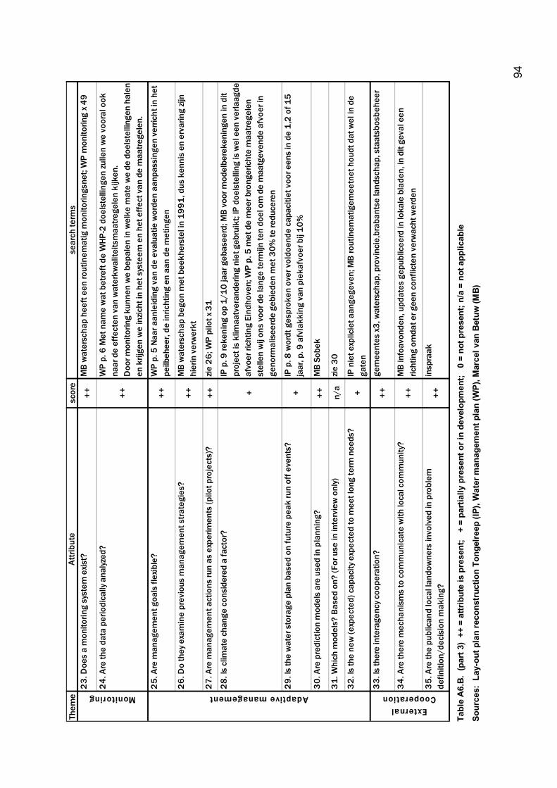
94
Them
e At
tribu
tesc
ore
sear
ch te
rms
23.
Doe
s a
mon
itorin
g sy
stem
exis
t?
++M
B w
ater
scha
p he
eft e
en ro
utin
emat
ig m
onito
rings
net;
WP
mon
itorin
g x 4
9
24.
Are
the
data
per
iodi
cally
ana
lyzed
?
++
WP
p. 6
Met
nam
e w
at b
etre
ft de
WHP
-2 d
oels
telli
ngen
zulle
n w
e vo
oral
ook
na
ar d
e ef
fect
en v
an w
ater
kwal
iteits
maa
trege
len
kijk
en.
Doo
r mon
itorin
g ku
nnen
we
bepa
len
in w
elke
mat
e w
e de
doe
lste
lling
en h
alen
en
krij
gen
we
inzic
ht in
het
sys
teem
en
het e
ffect
van
de
maa
trege
len.
25.
Are
man
agem
ent g
oals
flex
ible
? ++
WP
p. 5
Naa
r aan
leid
ing
van
de e
valu
atie
wor
den
aanp
assi
ngen
ver
richt
in h
et
peilb
ehee
r, de
inric
htin
g en
aan
de
met
inge
n
26.
Do
they
exa
min
e pr
evio
us m
anag
emen
t stra
tegi
es?
++M
B w
ater
scha
p be
gon
met
bee
kher
stel
in 1
991,
dus
ken
nis
en e
rvar
ing
zijn
hier
in v
erw
erkt
27.
Are
man
agem
ent a
ctio
ns ru
n as
exp
erim
ents
(pilo
t pro
ject
s)?
++zie
26;
WP
pilo
t x 3
1
28.
Is c
limat
e ch
ange
con
side
red
a fa
ctor
?
+
IP p
. 9 re
keni
ng o
p 1/
10 ja
ar g
ebas
eerd
; MB
voor
mod
elbe
reke
ning
en in
dit
proj
ect i
s kl
imaa
tver
ande
ring
niet
geb
ruik
t; IP
doe
lste
lling
is w
el e
en v
erla
agde
af
voer
rich
ting
Eind
hove
n; W
P p.
5 m
et d
e m
eer b
rong
eric
hte
maa
trege
len
stel
len
wij
ons
voor
de
lang
e te
rmijn
ten
doel
om
de
maa
tgev
ende
afv
oer i
n ge
norm
alis
eerd
e ge
bied
en m
et 3
0% te
redu
cere
n
29.
Is th
e w
ater
sto
rage
pla
n ba
sed
on fu
ture
pea
k ru
n of
f eve
nts?
+IP
p. 8
wor
dt g
espr
oken
ove
r vol
doen
de c
apac
itiet
voo
r een
s in
de
1,2
of 1
5 ja
ar, p
. 9 a
fvla
kkin
g va
n pi
ekaf
voer
bij
10%
30.
Are
pre
dict
ion
mod
els
are
used
in p
lann
ing?
++M
B So
bek
31.
Whi
ch m
odel
s? B
ased
on?
(For
use
in in
terv
iew
onl
y)n/
azie
30
32.
Is th
e ne
w (e
xpec
ted)
cap
acity
exp
ecte
d to
mee
t lon
g te
rm n
eeds
?+
IP n
iet e
xplic
iet a
ange
geve
n; M
B ro
utin
emat
igem
eetn
et h
oudt
dat
wel
in d
e ga
ten
33.
Is th
ere
inte
rage
ncy c
oope
ratio
n?++
gem
eent
es x
3, w
ater
scha
p, p
rovi
ncie
,bra
bant
se la
ndsc
hap,
sta
atsb
osbe
heer
34.
Are
ther
e m
echa
nism
s to
com
mun
icat
e w
ith lo
cal c
omm
unity
? ++
MB
info
avon
den,
upd
ates
gep
ublic
eerd
in lo
kale
bla
den,
in d
it ge
val e
en
richt
ing
omda
t er g
een
conf
licte
n ve
rwac
ht w
erde
n
35.
Are
the
publ
ican
d lo
cal l
ando
wne
rs in
volv
ed in
pro
blem
de
finiti
on/d
ecis
ion
mak
ing?
++
insp
raak
External Cooperation Monitoring Adaptive management
Ta
ble
A6.
B. (
part
3)
++ =
attr
ibut
e is
pre
sent
; +
= p
artia
lly p
rese
nt o
r in
deve
lopm
ent;
0 =
not
pre
sent
; n/a
= n
ot a
pplic
able
Sour
ces:
Lay
-out
pla
n re
cons
truc
tion
Tong
elre
ep (I
P), W
ater
man
agem
ent p
lan
(WP)
, Mar
cel v
an B
etuw
(MB)
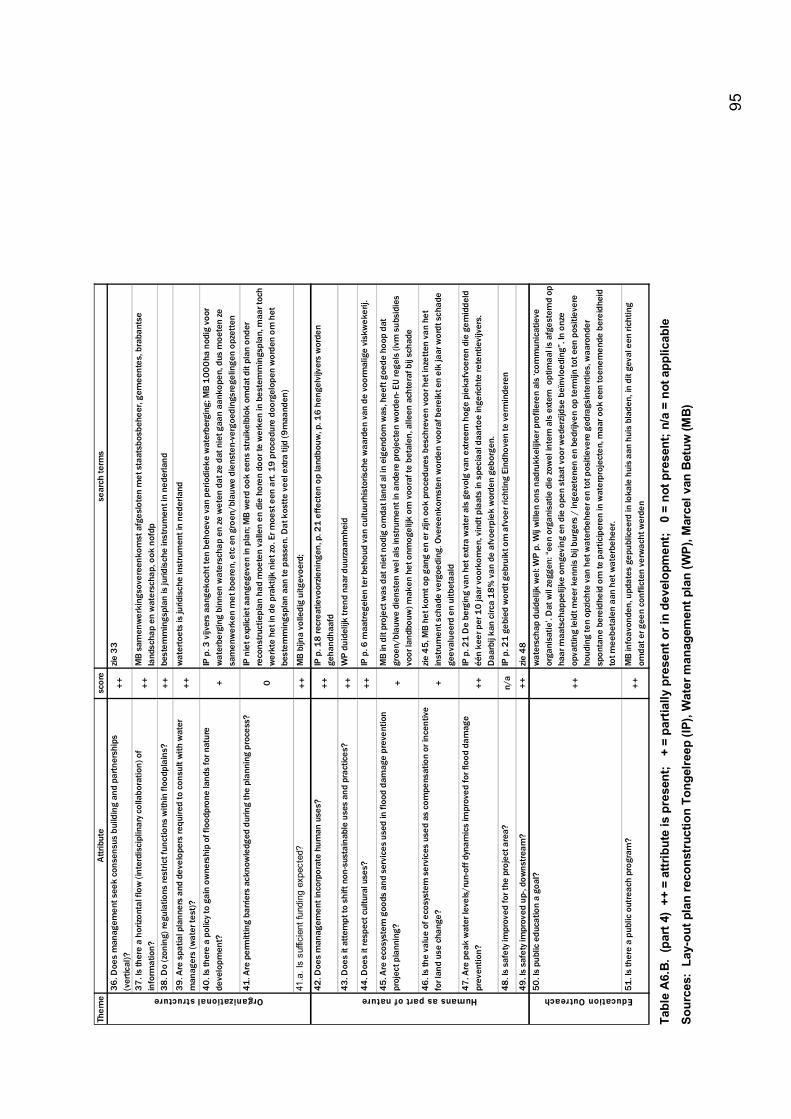
95
Them
e At
tribu
tesc
ore
sear
ch te
rms
36. D
oes
man
agem
ent s
eek
cons
ensu
s bu
ildin
g an
d pa
rtner
ship
s (v
ertic
al)?
++zie
33
37. I
s th
ere
a ho
rizon
tal f
low
(int
erdi
scip
linar
y col
labo
ratio
n) o
f in
form
atio
n?
++M
B sa
men
wer
king
sove
reen
kom
st a
fges
lote
n m
et s
taat
sbos
behe
er, g
emee
ntes
, bra
bant
se
land
scha
p en
wat
ersc
hap,
ook
nof
dp38
. Do
(zon
ing)
regu
latio
ns re
stric
t fun
ctio
ns w
ithin
floo
dpla
ins?
++be
stem
min
gspl
an is
jurid
isch
e in
stru
men
t in
nede
rland
39. A
re s
patia
l pla
nner
s an
d de
velo
pers
requ
ired
to c
onsu
lt w
ith w
ater
m
anag
ers
(wat
er te
st)?
++w
ater
toet
s is
jurid
isch
e in
stru
men
t in
nede
rland
40. I
s th
ere
a po
licy t
o ga
in o
wne
rshi
p of
floo
dpro
ne la
nds
for n
atur
e de
velo
pmen
t?+
IP p
. 3 v
ijver
s aa
ngek
ocht
ten
beho
eve
van
perio
diek
e w
ater
berg
ing;
MB
1000
ha n
odig
voo
r w
ater
berg
ing
binn
en w
ater
scha
p en
ze w
eten
dat
ze d
at n
iet g
aan
aank
open
, dus
moe
ten
ze
sam
enw
erke
n m
et b
oere
n, e
tc e
n gr
oen/
blau
we
dien
sten
-ver
goed
ings
rege
linge
n op
zette
n
41. A
re p
erm
ittin
g ba
rrier
s ac
know
ledg
ed d
urin
g th
e pl
anni
ng p
roce
ss?
0
IP n
iet e
xplic
iet a
ange
geve
n in
pla
n; M
B w
erd
ook
eens
stru
ikel
blok
om
dat d
it pl
an o
nder
re
cons
truct
iepl
an h
ad m
oete
n va
llen
en d
ie h
oren
doo
r te
wer
ken
in b
este
mm
ings
plan
, maa
r toc
h w
erkt
e he
t in
de p
rakt
ijk n
iet z
o. E
r moe
st e
en a
rt. 1
9 pr
oced
ure
door
gelo
pen
wor
den
om h
et
best
emm
ings
plan
aan
te p
asse
n. D
at k
ostte
vee
l ext
ra ti
jd (9
maa
nden
)
41.a
. Is
suffi
cien
t fun
ding
exp
ecte
d?
++M
B bi
jna
volle
dig
uitg
evoe
rd;
42. D
oes
man
agem
ent i
ncor
pora
te h
uman
use
s?++
IP p
. 18
recr
eatie
voor
zieni
ngen
, p. 2
1 ef
fect
en o
p la
ndbo
uw, p
. 16
heng
elvi
jver
s w
orde
n ge
hand
haaf
d43
. Doe
s it
atte
mpt
to s
hift
non-
sust
aina
ble
uses
and
pra
ctic
es?
++W
P du
idel
ijk tr
end
naar
duu
rzaa
mhe
id
44. D
oes
it re
spec
t cul
tura
l use
s?
++IP
p. 6
maa
trege
len
ter b
ehou
d va
n cu
ltuur
hist
oris
che
waa
rden
van
de
voor
mal
ige
visk
wek
erij.
45. A
re e
cosy
stem
goo
ds a
nd s
ervi
ces
used
in fl
ood
dam
age
prev
entio
n pr
ojec
t pla
nnin
g?+
MB
in d
it pr
ojec
t was
dat
nie
t nod
ig o
mda
t lan
d al
in e
igen
dom
was
, hee
ft go
ede
hoop
dat
gr
oen/
blau
we
dien
sten
wel
als
inst
rum
ent i
n an
dere
pro
ject
en w
orde
n- E
U re
gels
(ivm
sub
sidi
es
voor
land
bouw
) mak
en h
et o
nmog
elijk
om
voo
raf t
e be
tale
n, a
lleen
ach
tera
f bij
scha
de
46. I
s th
e va
lue
of e
cosy
stem
ser
vice
s us
ed a
s co
mpe
nsat
ion
or in
cent
ive
for l
and
use
chan
ge?
+zie
45,
MB
het k
omt o
p ga
ng e
n er
zijn
ook
pro
cedu
res
besc
hrev
en v
oor h
et in
zette
n va
n he
t in
stru
men
t sch
ade
verg
oedi
ng. O
vere
enko
mst
en w
orde
n vo
oraf
ber
eikt
en
elk
jaar
wor
dt s
chad
e ge
eval
ueer
d en
uitb
etaa
ld
47. A
re p
eak
wat
er le
vels
/run
-off
dyna
mic
s im
prov
ed fo
r flo
od d
amag
e pr
even
tion?
++IP
p. 2
1 D
e be
rgin
g va
n he
t ext
ra w
ater
als
gev
olg
van
extre
em h
oge
piek
afvo
eren
die
gem
idde
ld
één
keer
per
10
jaar
voo
rkom
en, v
indt
pla
ats
in s
peci
aal d
aarto
e in
geric
hte
rete
ntie
vijv
ers.
D
aarb
ij ka
n ci
rca
18%
van
de
afvo
erpi
ek w
orde
n ge
borg
en.
48. I
s sa
fety
impr
oved
for t
he p
roje
ct a
rea?
n/a
IP p
. 21
gebi
ed w
ordt
geb
ruik
t om
afv
oer r
icht
ing
Eind
hove
n te
ver
min
dere
n
49. I
s sa
fety
impr
oved
up-
, dow
nstre
am?
++zie
48
50. I
s pu
blic
edu
catio
n a
goal
?
++
wat
ersc
hap
duid
elijk
wel
: WP
p. W
ij w
illen
ons
nad
rukk
elijk
er p
rofil
eren
als
�com
mun
icat
ieve
or
gani
satie
�. D
at w
il ze
ggen
: �ee
n or
gani
satie
die
zow
el in
tern
als
ext
ern
opt
imaa
l is
afge
stem
d op
ha
ar m
aats
chap
pelij
ke o
mge
ving
en
die
open
sta
at v
oor w
eder
zijds
e be
ïnvl
oedi
ng�.
In o
nze
opva
tting
leid
t mee
r ken
nis
bij b
urge
rs /
inge
zete
nen
en b
edrij
ven
op te
rmijn
tot e
en p
ositi
ever
e ho
udin
g te
n op
zicht
e va
n he
t wat
erbe
heer
en
tot p
ositi
ever
e ge
drag
sint
entie
s, w
aaro
nder
sp
onta
ne b
erei
dhei
d om
te p
artic
iper
en in
wat
erpr
ojec
ten,
maa
r ook
een
toen
emen
de b
erei
dhei
d to
t mee
beta
len
aan
het w
ater
behe
er.
51. I
s th
ere
a pu
blic
out
reac
h pr
ogra
m?
++M
B in
foav
onde
n, u
pdat
es g
epub
licee
rd in
loka
le h
uis
aan
huis
bla
den,
in d
it ge
val e
en ri
chtin
g om
dat e
r gee
n co
nflic
ten
verw
acht
wer
den
Education OutreachOrganizational structure Humans as part of nature
Ta
ble
A6.
B. (
part
4)
++ =
attr
ibut
e is
pre
sent
; +
= p
artia
lly p
rese
nt o
r in
deve
lopm
ent;
0 =
not
pre
sent
; n/a
= n
ot a
pplic
able
Sour
ces:
Lay
-out
pla
n re
cons
truc
tion
Tong
elre
ep (I
P), W
ater
man
agem
ent p
lan
(WP)
, Mar
cel v
an B
etuw
(MB)
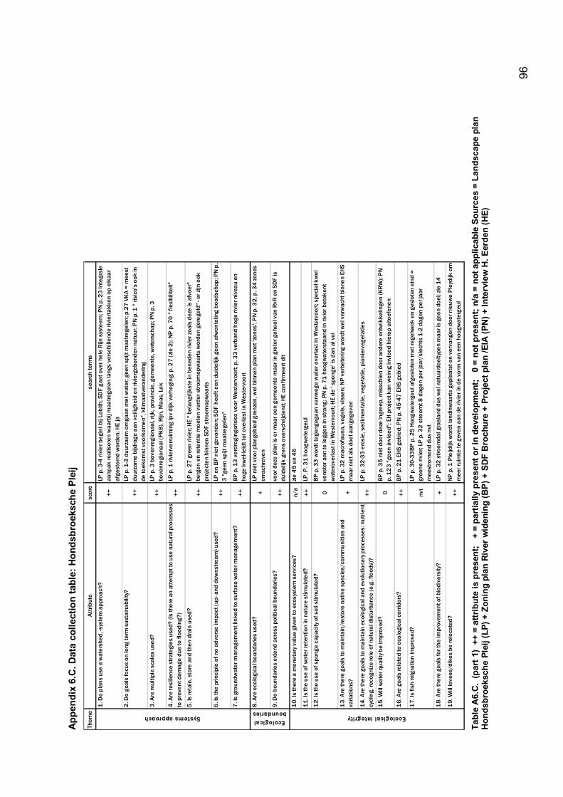
96
Appe
ndix
6.C
. Dat
a co
llect
ion
tabl
e: H
onds
broe
ksch
e Pl
eij
Them
e At
tribu
tesc
ore
sear
ch te
rms
1. D
o pl
ans
use
a w
ater
shed
, -sy
stem
app
roac
h?++
LP p
. 3-4
rivi
er b
egin
t bij
Lobi
th; S
DF
gaat
ove
r hel
e Ri
jn s
yste
em; P
N p.
23
Inte
gral
e aa
npak
real
iser
en w
aarb
ij m
aatre
gele
n la
ngs
vers
chill
ende
rivi
erta
kken
op
elka
ar
afge
stem
d w
orde
n; H
E ja
2. D
o go
als
focu
s on
long
term
sus
tain
abili
ty?
++LP
p. 1
-3 d
uurz
aam
om
gaan
met
wat
er; g
een
spijt
maa
trege
len;
p.2
7 V
KA
= m
eest
du
urza
me
bijd
rage
aan
vei
lighe
id e
n riv
ierg
ebon
den
natu
ur; P
N p.
1 "
risic
o's
ook
in
de to
ekom
st v
oork
omen
", k
limaa
tver
ande
ring
3. A
re m
ultip
le s
cale
s us
ed?
++LP
p. 3
bov
enre
gion
aal,
rijk,
pro
vinc
ie, g
emee
nte,
wat
ersc
hap;
PN
p. 3
bo
venr
egio
naal
(PK
B), R
ijn, M
aas,
Lek
4. A
re re
silie
nce
stra
tegi
es u
sed?
(Is
ther
e an
att
empt
to u
se n
atur
al p
roce
sses
to
pre
vent
dam
age
due
to fl
oodi
ng?)
++LP
p. 1
rivi
erve
rruim
ing
ipv
dijk
ver
hogi
ng; p
. 27
(zie
2);
NP p
. 70
" fle
xibi
litei
t"
5. Is
reta
in, s
tore
and
then
dra
in u
sed?
++LP
p. 2
7 g
reen
rivi
er; H
E " b
elan
grijk
ste
in b
ened
en ri
vier
zoal
s de
ze is
afv
oer"
be
rgen
en
rete
ntie
moe
ten
verd
er s
troo
mop
waa
rts
wor
den
gere
geld
" - e
r zijn
ook
pr
ojec
ten
binn
en S
DF
stro
omop
waa
rts
6. Is
the
prin
cipl
e of
no
adve
rse
impa
ct (u
p- a
nd d
owns
tream
) use
d?++
LP e
n B
P ni
et g
evon
den;
SD
F he
eft e
en d
uide
lijk
geen
afw
ente
ling
bood
scha
p; P
N p
. 3
"gee
n sp
ijt m
aatre
gele
n"
7. Is
gro
undw
ater
man
agem
ent l
inke
d to
sur
face
wat
er m
anag
emen
t?++
BP p
. 13
ver
drog
ings
risic
o vo
or W
este
rvoo
rt; p
. 33
verb
and
hoge
rivi
er n
ivea
u en
ho
ge k
wel
-leid
t tot
ove
rlast
in W
este
rvoo
rt
8. A
re e
colo
gica
l bou
ndar
ies
used
?+
LP n
iet v
oor p
lang
ebie
d gr
enze
n, w
el b
inne
n pl
an m
et 'z
ones
'; P
N p.
32,
p. 3
4 zo
nes
omsc
hrev
en
9. D
o bo
unda
ries
exte
nd a
cros
s po
litic
al b
ound
arie
s?++
voor
dez
e pl
an is
er m
aar e
en g
emee
nte
maa
r in
grot
er g
ehee
l van
RvR
en
SDF
is
duid
elijk
gre
ns o
vers
chrij
dend
; HE
conf
irmee
rt d
it
10.
Is th
ere
a m
onet
ary v
alue
giv
en to
eco
syst
em s
ervi
ces?
n/
azie
45
en 4
6
11.
Is th
e us
e of
wat
er re
tent
ion
in n
atur
e st
imul
ated
?++
LP. P
. 31
hoog
wat
erge
ul
12.
Is th
e us
e of
spo
nge
capa
city
of s
oil s
timul
ated
?0
BP p
. 33
wor
dt te
geng
egaa
n va
nweg
e w
ater
ove
rlast
in W
este
rvoo
rt; s
peci
al k
wel
ve
nste
r aan
te le
ggen
in s
trang
; PN
p. 7
1 ho
ogw
ater
staa
nd in
rivi
er b
etek
ent
wat
erov
erla
st in
Wes
terv
oort
; HE
de '
spon
ge' i
s da
n al
vol
13. A
re th
ere
goal
s to
mai
ntai
n/re
stor
e na
tive
spec
ies/
com
mun
ities
and
va
riatio
ns?
+LP
p. 3
2 m
acro
faun
a, v
ogel
s, v
isse
n; N
P v
erbe
terin
g w
ordt
wel
ver
wac
ht b
inne
n EH
S m
aar n
iet a
ls d
oel a
ange
geve
n
14. A
re th
ere
goal
s to
mai
ntai
n ec
olog
ical
and
evo
lutio
nary
pro
cess
es: n
utrie
nt
cycl
ing,
reco
gniz
e ro
le o
f nat
ural
dis
turb
ance
(e.g
. flo
ods)
?++
LP p
. 32-
33 e
rosi
e, s
edim
enta
tie, v
eget
atie
, pio
nier
vege
tatie
s
15.
Will
wat
er q
ualit
y be
impr
oved
?0
BP p
. 35
nie
t doo
r dez
e in
gree
p, m
issc
hien
doo
r and
ere
ontw
ikke
linge
n (K
RW
); P
N p.
12
3 "g
een
invl
oed"
; EH
pro
ject
kan
wei
nig
invl
oed
hier
op u
itoef
enen
16.
Are
goa
ls re
late
d to
eco
logi
cal c
orrid
ors?
++BP
p. 2
1 EH
S ge
bied
; PN
p. 4
5-47
EH
S ge
bied
17. I
s fis
h m
igra
tion
impr
oved
?nv
tLP
p. 3
0-33
BP p
. 25
Hoo
gwat
erge
ul a
fges
lote
n m
et re
gelw
erk
en g
eslo
ten
eind
=
groe
ne ri
vier
; LP
p. 3
2 st
room
t 8 d
agen
per
jaar
/sle
chts
1-2
dag
en p
er ja
ar
mee
stro
men
d du
s nv
t1
8. A
re th
ere
goal
s fo
r the
impr
ovem
ent o
f bio
dive
rsity
?+
LP p
. 32
str
oom
dal g
rasl
and
dus
wel
nat
uurd
oelty
pen
maa
r is
geen
doe
l; zie
14
19. W
ill le
vees
/dik
es b
e re
loca
ted?
++NP
p. 1
Ple
ijdijk
wor
dt la
ndin
waa
rts
gepl
aats
t en
verv
ange
n do
or n
ieuw
e Pl
eydi
jk o
m
mee
r rui
mte
te g
even
aan
de
rivie
r in
de v
orm
van
een
hoo
gwat
erge
ul
Systems approachEcological boundaries
Ecological integrity
Ta
ble
A6.
C. (
part
1)
++ =
attr
ibut
e is
pre
sent
; +
= p
artia
lly p
rese
nt o
r in
deve
lopm
ent;
0 =
not
pre
sent
; n/a
= n
ot a
pplic
able
Sou
rces
= L
ands
cape
pla
n H
onds
broe
ksch
e Pl
eij (
LP) +
Zon
ing
plan
Riv
er w
iden
ing
(BP)
+ S
DF
Bro
chur
e +
Proj
ect p
lan
/EIA
(PN
) + In
terv
iew
H. E
erde
n (H
E)
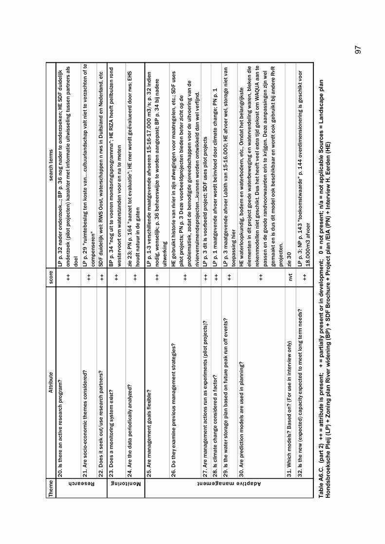
97
Them
e At
tribu
tesc
ore
sear
ch te
rms
20. I
s th
ere
an a
ctiv
e re
sear
ch p
rogr
am?
++LP
p. 3
2 na
der o
nder
zoek
�; B
P p.
36
nog
nade
r te
onde
rzoe
ken;
HE
SDF
duid
elijk
on
derz
oek
(pilo
t pro
ject
en) k
arak
ter m
et in
form
atie
uitw
isse
ling
tuss
en p
artn
ers
als
doel
21. A
re s
ocio
-eco
nom
ic th
emes
con
side
red?
++
LP p
. 29
"rui
mte
besl
ag te
n ko
ste
van�
.cul
tuur
land
scha
p va
lt ni
et te
ver
zach
ten
of te
co
mpe
nser
en"
22. D
oes
it se
ek o
ut/u
se re
sear
ch p
artn
ers?
++SD
F du
idel
ijk w
el: R
WS
Oost
, wat
ersc
happ
en n
rws
in D
uits
land
en
Nede
rland
, etc
23. D
oes
a m
onito
ring
syst
em e
xist?
++
BP p
. 34
"nog
uit
te v
oere
n m
onito
rings
prog
ram
ma"
; HE
RIZA
hee
ft pe
ilbui
zen
rond
w
este
rvoo
rt om
wat
erst
ande
n vo
or e
n na
te m
eten
24. A
re th
e da
ta p
erio
dica
lly a
nalyz
ed?
++zie
23;
PN
p. 1
64 "a
anze
t tot
eva
luat
ie";
HE m
er w
ordt
geë
valu
eerd
doo
r rw
s; E
HS
houd
t nat
uur i
n de
gat
en
25. A
re m
anag
emen
t goa
ls fl
exib
le?
++LP
p. 1
-3 v
ersc
hille
nde
maa
tgev
ende
afv
oere
n 15
-16-
17.0
00 m
3/s;
p. 3
2 in
dien
no
dig,
wen
selij
k; p
. 36
behe
ersw
ijze
te w
orde
n aa
ngep
ast;
BP p
. 34
bij n
ader
e ui
twer
king
26. D
o th
ey e
xam
ine
prev
ious
man
agem
ent s
trate
gies
?
++
HE g
ebru
ikt h
isto
rie v
an ri
vier
in zi
jn a
fweg
inge
n vo
or m
aatr
egel
en, e
tc.;
SDF
uses
pi
lot p
roje
cts;
PN
p. 3
Dez
e vo
orbe
eldp
roje
cten
bie
den
bete
r zic
ht o
p de
pr
oble
mat
iek,
zoda
t de
beno
digd
e ge
reed
scha
ppen
voo
r de
uitv
oerin
g va
n de
riv
ierv
erru
imen
depr
ojec
ten.
..kun
nen
wor
den
ontw
ikke
ld d
an w
el v
erfij
nd.
27. A
re m
anag
emen
t act
ions
run
as e
xper
imen
ts (p
ilot p
roje
cts)
?++
LP p
. 3 d
it is
voo
rbee
ld p
roje
ct; S
DF
uses
pilo
t pro
ject
s
28. I
s cl
imat
e ch
ange
con
side
red
a fa
ctor
?++
LP p
. 1 m
aatg
even
de a
fvoe
r wor
dt b
eïnv
loed
doo
r clim
ate
chan
ge; P
N p.
1
29. I
s th
e w
ater
sto
rage
pla
n ba
sed
on fu
ture
pea
k ru
n of
f eve
nts?
++LP
p. 3
maa
tgev
ende
afv
oer L
obith
van
15-
16.0
00; H
E af
voer
wel
, sto
rage
nie
t van
to
epas
sing
hie
r 30
. Are
pre
dict
ion
mod
els
are
used
in p
lann
ing?
++
HE w
ater
loop
kund
ig, b
odem
en
wat
erbo
dem
, etc
., Om
dat h
et b
elan
grijk
ste
elem
ente
n in
dit
proj
ect g
oede
wat
erbe
weg
ing
en w
ater
verd
elin
g w
aren
, ble
ken
die
reke
nmod
elle
n ni
et g
esch
ikt.
Dus
het
hee
ft ve
el e
xtra
tijd
gek
ost o
m W
AQUA
aan
te
pass
en e
n de
goe
de ra
ndvo
orw
aard
en e
rin te
krij
gen.
Dez
e aa
npas
sing
en zi
jn w
el
gem
aakt
en
is d
us d
it m
odel
ook
bes
chik
baar
en
wor
dt o
ok g
ebru
ikt b
ij an
dere
RvR
pr
ojec
ten.
31
. Whi
ch m
odel
s? B
ased
on?
(For
use
in in
terv
iew
onl
y)nv
tzie
30
32. I
s th
e ne
w (e
xpec
ted)
cap
acity
exp
ecte
d to
mee
t lon
g te
rm n
eeds
?++
LP p
. 3; N
P p.
143
"toe
kom
stw
aard
e" p
. 144
ove
rdim
ensi
oner
ing
is g
esch
ikt v
oor
18.0
00m
3 af
voer
Research Monitoring Adaptive management
Ta
ble
A6.
C. (
part
2)
++ =
attr
ibut
e is
pre
sent
; +
= p
artia
lly p
rese
nt o
r in
deve
lopm
ent;
0 =
not
pre
sent
; n/a
= n
ot a
pplic
able
Sou
rces
= L
ands
cape
pla
n H
onds
broe
ksch
e Pl
eij (
LP) +
Zon
ing
plan
Riv
er w
iden
ing
(BP)
+ S
DF
Bro
chur
e +
Proj
ect p
lan
/EIA
(PN
) + In
terv
iew
H. E
erde
n (H
E)
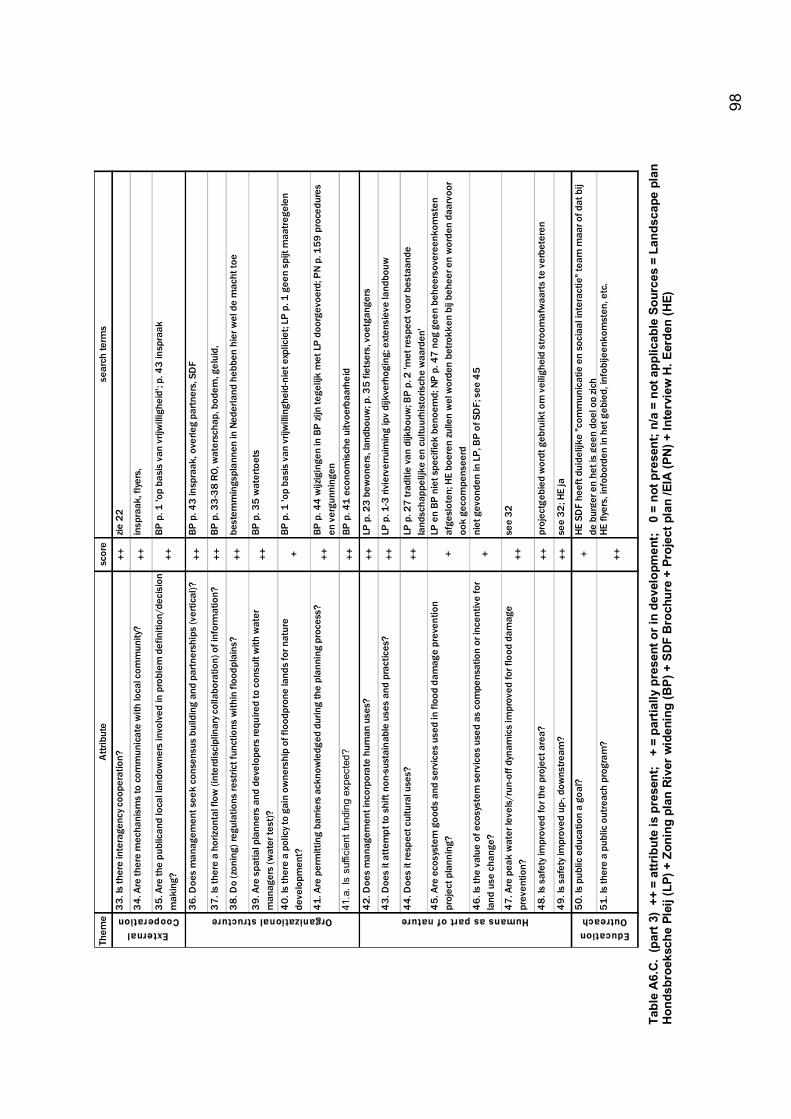
98
Them
e At
tribu
tesc
ore
sear
ch te
rms
33. I
s th
ere
inte
rage
ncy c
oope
ratio
n?++
zie 2
2
34. A
re th
ere
mec
hani
sms
to c
omm
unic
ate
with
loca
l com
mun
ity?
++in
spra
ak, f
lyers
,
35. A
re th
e pu
blic
and
loca
l lan
dow
ners
invo
lved
in p
robl
em d
efin
ition
/dec
isio
n m
akin
g?
++BP
p. 1
'op
basi
s va
n vr
ijwill
ighe
id';
p. 4
3 in
spra
ak
36. D
oes
man
agem
ent s
eek
cons
ensu
s bu
ildin
g an
d pa
rtner
ship
s (v
ertic
al)?
++BP
p. 4
3 in
spra
ak, o
verle
g pa
rtne
rs, S
DF
37. I
s th
ere
a ho
rizon
tal f
low
(int
erdi
scip
linar
y col
labo
ratio
n) o
f inf
orm
atio
n?
++BP
p. 3
3-38
RO,
wat
ersc
hap,
bod
em, g
elui
d,
38. D
o (z
onin
g) re
gula
tions
rest
rict f
unct
ions
with
in fl
oodp
lain
s?++
best
emm
ings
plan
nen
in N
eder
land
heb
ben
hier
wel
de
mac
ht to
e
39. A
re s
patia
l pla
nner
s an
d de
velo
pers
requ
ired
to c
onsu
lt w
ith w
ater
m
anag
ers
(wat
er te
st)?
++BP
p. 3
5 w
ater
toet
s
40. I
s th
ere
a po
licy t
o ga
in o
wne
rshi
p of
floo
dpro
ne la
nds
for n
atur
e de
velo
pmen
t?+
BP p
. 1 'o
p ba
sis
van
vrijw
illin
ghei
d-ni
et e
xplic
iet;
LP p
. 1 g
een
spijt
maa
treg
elen
41. A
re p
erm
ittin
g ba
rrier
s ac
know
ledg
ed d
urin
g th
e pl
anni
ng p
roce
ss?
++BP
p. 4
4 w
ijzig
inge
n in
BP
zijn
tege
lijk
met
LP
doo
rgev
oerd
; PN
p. 1
59 p
roce
dure
s en
ver
gunn
inge
n41
.a. I
s su
ffici
ent f
undi
ng e
xpec
ted?
++
BP p
. 41
econ
omis
che
uitv
oerb
aarh
eid
42. D
oes
man
agem
ent i
ncor
pora
te h
uman
use
s?++
LP p
. 23
bew
oner
s, la
ndbo
uw; p
. 35
fiets
ers,
voe
tgan
gers
43. D
oes
it at
tem
pt to
shi
ft no
n-su
stai
nabl
e us
es a
nd p
ract
ices
?++
LP p
. 1-3
rivi
erve
rrui
min
g ip
v di
jkve
rhog
ing;
ext
ensi
eve
land
bouw
44. D
oes
it re
spec
t cul
tura
l use
s?
++LP
p. 2
7 tr
aditi
e va
n di
jkbo
uw; B
P p.
2 'm
et re
spec
t voo
r bes
taan
de
land
scha
ppel
ijke
en c
ultu
urhi
stor
isch
e w
aard
en'
45. A
re e
cosy
stem
goo
ds a
nd s
ervi
ces
used
in fl
ood
dam
age
prev
entio
n pr
ojec
t pla
nnin
g?+
LP e
n BP
nie
t spe
cifie
k be
noem
d; N
P p.
47
nog
geen
beh
eers
over
eenk
omst
en
afge
slot
en; H
E bo
eren
zul
len
wel
wor
den
betro
kken
bij
behe
er e
n w
orde
n da
arvo
or
ook
geco
mpe
nsee
rd46
. Is
the
valu
e of
eco
syst
em s
ervi
ces
used
as
com
pens
atio
n or
ince
ntiv
e fo
r la
nd u
se c
hang
e?+
niet
gev
onde
n in
LP,
BP
of S
DF;
see
45
47. A
re p
eak
wat
er le
vels
/run
-off
dyna
mic
s im
prov
ed fo
r flo
od d
amag
e pr
even
tion?
++se
e 32
48. I
s sa
fety
impr
oved
for t
he p
roje
ct a
rea?
++pr
ojec
tgeb
ied
wor
dt g
ebru
ikt o
m v
eilig
heid
str
oom
afw
aart
s te
ver
bete
ren
49. I
s sa
fety
impr
oved
up-
, dow
nstre
am?
++se
e 32
; HE
ja
50. I
s pu
blic
edu
catio
n a
goal
? +
HE S
DF
heef
t dui
delij
ke "c
omm
unic
atie
en
soci
aal i
nter
actie
" tea
m m
aar o
f dat
bij
de b
urge
r en
het i
s ge
en d
oel o
p zi
ch51
. Is
ther
e a
publ
ic o
utre
ach
prog
ram
?++
HE fl
yers
, inf
obor
den
in h
et g
ebie
d, in
fobi
jeen
kom
sten
, etc
.
Education Outreach
External Cooperation Organizational structure Humans as part of nature
Ta
ble
A6.
C. (
part
3)
++ =
attr
ibut
e is
pre
sent
; +
= p
artia
lly p
rese
nt o
r in
deve
lopm
ent;
0 =
not
pre
sent
; n/a
= n
ot a
pplic
able
Sou
rces
= L
ands
cape
pla
n H
onds
broe
ksch
e Pl
eij (
LP) +
Zon
ing
plan
Riv
er w
iden
ing
(BP)
+ S
DF
Bro
chur
e +
Proj
ect p
lan
/EIA
(PN
) + In
terv
iew
H. E
erde
n (H
E)
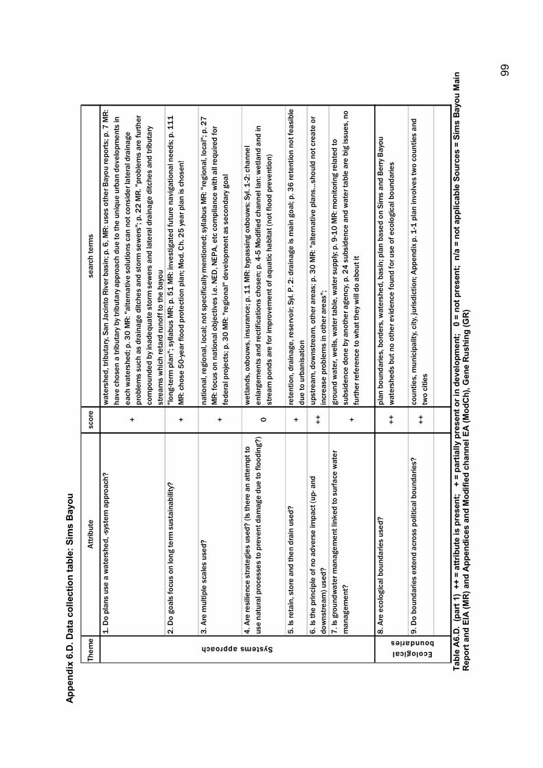
99
Appe
ndix
6.D
. Dat
a co
llect
ion
tabl
e: S
ims
Bay
ou
Them
e At
tribu
tesc
ore
sear
ch te
rms
1. D
o pl
ans
use
a w
ater
shed
, -sy
stem
app
roac
h?
+
wat
ersh
ed, t
ribut
ary,
San
Jaci
nto
Rive
r bas
in; p
. 6, M
R: u
ses
othe
r Bay
ou re
ports
; p. 7
MR:
ha
ve c
hose
n a
tribu
tary
by t
ribut
ary a
ppro
ach
due
to th
e un
ique
urb
an d
evel
opm
ents
in
each
wat
ersh
ed; p
. 30
MR:
"alte
rnat
ive
solu
tions
can
not
con
side
r lat
eral
dra
inag
e pr
oble
ms
such
as
drai
nage
ditc
hes
and
stor
m s
ewer
s"; p
. 22
MR.
"pro
blem
s ar
e fu
rther
co
mpo
unde
d by
inad
equa
te s
torm
sew
ers
and
late
ral d
rain
age
ditc
hes
and
tribu
tary
st
ream
s w
hich
reta
rd ru
noff
to th
e ba
you
2. D
o go
als
focu
s on
long
term
sus
tain
abili
ty?
+"lo
ng-te
rm p
lan"
; syll
abus
MR;
p. 5
1 M
R: in
vest
igat
ed fu
ture
nav
igat
iona
l nee
ds; p
. 111
M
R: c
hose
50-
year
floo
d pr
otec
tion
plan
; Mod
. Ch.
25
year
pla
n is
cho
sen!
3. A
re m
ultip
le s
cale
s us
ed?
+
natio
nal,
regi
onal
, loc
al; n
ot s
peci
fical
ly m
entio
ned;
syll
abus
MR:
"reg
iona
l, lo
cal";
p. 2
7 M
R: fo
cus
on n
atio
nal o
bjec
tives
i.e.
NED
, NEP
A, e
tc c
ompl
ianc
e w
ith a
ll re
quire
d fo
r fe
dera
l pro
ject
s; p
. 30
MR:
"reg
iona
l" de
velo
pmen
t as
seco
ndar
y go
al
4. A
re re
silie
nce
stra
tegi
es u
sed?
(Is
ther
e an
atte
mpt
to
use
natu
ral p
roce
sses
to p
reve
nt d
amag
e du
e to
floo
ding
?)0
wet
land
s, o
xbou
ws,
insu
ranc
e; p
. 11
MR:
byp
assi
ng o
xbou
ws;
Syl
. 1-2
: cha
nnel
en
larg
emen
ts a
nd re
ctifi
catio
ns c
hose
n; p
. 4-5
Mod
ified
cha
nnel
lan:
wet
land
and
in
stre
am p
onds
are
for i
mpr
ovem
ent o
f aqu
atic
hab
itat (
not f
lood
pre
vent
ion)
5. Is
reta
in, s
tore
and
then
dra
in u
sed?
+re
tent
ion,
dra
inag
e, re
serv
oir;
Syl.
P. 2
: dra
inag
e is
mai
n go
al; p
. 36
rete
ntio
n no
t fea
sibl
e du
e to
urb
anis
atio
n 6.
Is th
e pr
inci
ple
of n
o ad
vers
e im
pact
(up-
and
do
wns
tream
) use
d?++
upst
ream
, dow
nstre
am, o
ther
are
as; p
. 30
MR:
"alte
rnat
ive
plan
s�sh
ould
not
cre
ate
or
incr
ease
pro
blem
s in
oth
er a
reas
"; 7.
Is g
roun
dwat
er m
anag
emen
t lin
ked
to s
urfa
ce w
ater
m
anag
emen
t?+
grou
nd w
ater
, wel
ls, w
ater
tabl
e, w
ater
sup
ply;
p. 9
-10
MR:
mon
itorin
g re
late
d to
su
bsid
ence
don
e by
ano
ther
age
ncy,
p. 2
4 su
bsid
ence
and
wat
er ta
ble
are
big
issu
es, n
o fu
rther
refe
renc
e to
wha
t the
y will
do
abou
t it
8. A
re e
colo
gica
l bou
ndar
ies
used
?++
plan
bou
ndar
ies,
bor
ders
, wat
ersh
ed, b
asin
; pla
n ba
sed
on S
ims
and
Berry
Bay
ou
wat
ersh
eds
but n
o ot
her e
vide
nce
foun
d fo
r use
of e
colo
gica
l bou
ndar
ies
9. D
o bo
unda
ries
exte
nd a
cros
s po
litic
al b
ound
arie
s?++
coun
ties,
mun
icip
ality
, city
, jur
isdi
ctio
n; A
ppen
dix p
. 1-1
pla
n in
volv
es tw
o co
untie
s an
d tw
o ci
ties
Ecological boundaries
Systems approach
Ta
ble
A6.
D. (
part
1)
++ =
attr
ibut
e is
pre
sent
; +
= p
artia
lly p
rese
nt o
r in
deve
lopm
ent;
0 =
not
pre
sent
; n/
a =
not a
pplic
able
Sou
rces
= S
ims
Bayo
u M
ain
Rep
ort a
nd E
IA (M
R) a
nd A
ppen
dice
s an
d M
odifi
ed c
hann
el E
A (M
odC
h), G
ene
Rus
hing
(GR
)
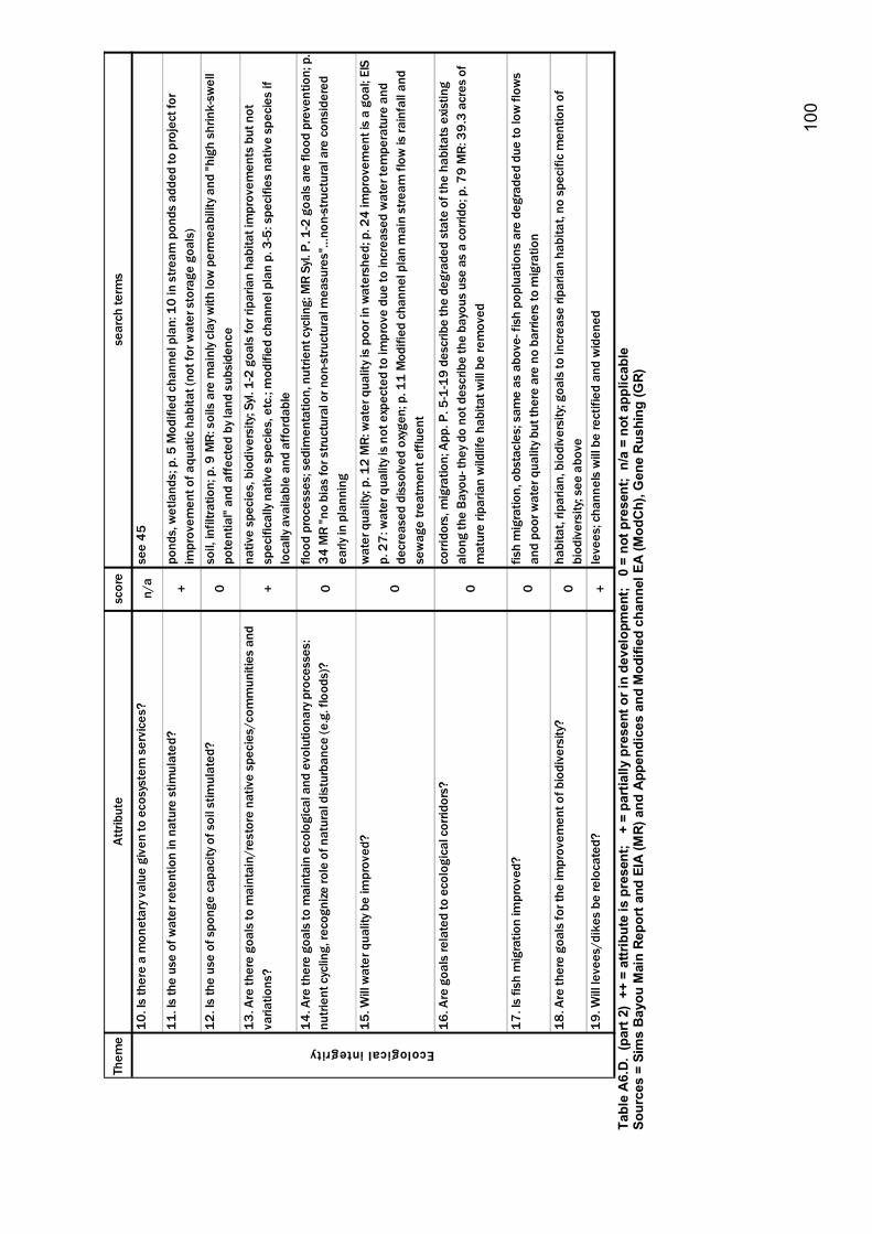
10
0
Them
e At
tribu
tesc
ore
sear
ch te
rms
10. I
s th
ere
a m
onet
ary v
alue
giv
en to
eco
syst
em s
ervi
ces?
n/a
see
45
11. I
s th
e us
e of
wat
er re
tent
ion
in n
atur
e st
imul
ated
?+
pond
s, w
etla
nds;
p. 5
Mod
ified
cha
nnel
pla
n: 1
0 in
stre
am p
onds
add
ed to
pro
ject
for
impr
ovem
ent o
f aqu
atic
hab
itat (
not f
or w
ater
sto
rage
goa
ls)
12. I
s th
e us
e of
spo
nge
capa
city
of s
oil s
timul
ated
?0
soil,
infil
tratio
n; p
. 9 M
R: s
oils
are
mai
nly c
lay w
ith lo
w p
erm
eabi
lity a
nd "h
igh
shrin
k-sw
ell
pote
ntia
l" an
d af
fect
ed b
y lan
d su
bsid
ence
13. A
re th
ere
goal
s to
mai
ntai
n/re
stor
e na
tive
spec
ies/
com
mun
ities
and
va
riatio
ns?
+na
tive
spec
ies,
bio
dive
rsity
; Syl.
1-2
goa
ls fo
r rip
aria
n ha
bita
t im
prov
emen
ts b
ut n
ot
spec
ifica
lly n
ativ
e sp
ecie
s, e
tc.;
mod
ified
cha
nnel
pla
n p.
3-5
: spe
cifie
s na
tive
spec
ies
if lo
cally
ava
ilabl
e an
d af
ford
able
14. A
re th
ere
goal
s to
mai
ntai
n ec
olog
ical
and
evo
lutio
nary
pro
cess
es:
nutri
ent c
yclin
g, re
cogn
ize ro
le o
f nat
ural
dis
turb
ance
(e.g
. flo
ods)
?0
flood
pro
cess
es; s
edim
enta
tion,
nut
rient
cyc
ling;
MR
Syl.
P. 1
-2 g
oals
are
floo
d pr
even
tion;
p.
34 M
R "n
o bi
as fo
r stru
ctur
al o
r non
-stru
ctur
al m
easu
res"
�no
n-st
ruct
ural
are
con
side
red
early
in p
lann
ing
15. W
ill w
ater
qua
lity b
e im
prov
ed?
0
wat
er q
ualit
y; p.
12
MR:
wat
er q
ualit
y is
poor
in w
ater
shed
; p. 2
4 im
prov
emen
t is
a go
al; E
IS
p. 2
7: w
ater
qua
lity i
s no
t exp
ecte
d to
impr
ove
due
to in
crea
sed
wat
er te
mpe
ratu
re a
nd
decr
ease
d di
ssol
ved
oxyg
en; p
. 11
Mod
ified
cha
nnel
pla
n m
ain
stre
am fl
ow is
rain
fall
and
sew
age
treat
men
t effl
uent
16. A
re g
oals
rela
ted
to e
colo
gica
l cor
ridor
s?
0
corri
dors
, mig
ratio
n; A
pp. P
. 5-1
-19
desc
ribe
the
degr
aded
sta
te o
f the
hab
itats
exis
ting
alon
g th
e Ba
you-
they
do
not d
escr
ibe
the
bayo
us u
se a
s a
corri
do; p
. 79
MR:
39.
3 ac
res
of
mat
ure
ripar
ian
wild
life
habi
tat w
ill b
e re
mov
ed
17. I
s fis
h m
igra
tion
impr
oved
?0
fish
mig
ratio
n, o
bsta
cles
; sam
e as
abo
ve- f
ish
popl
uatio
ns a
re d
egra
ded
due
to lo
w fl
ows
and
poor
wat
er q
ualit
y but
ther
e ar
e no
bar
riers
to m
igra
tion
18. A
re th
ere
goal
s fo
r the
impr
ovem
ent o
f bio
dive
rsity
?0
habi
tat,
ripar
ian,
bio
dive
rsity
; goa
ls to
incr
ease
ripa
rian
habi
tat,
no s
peci
fic m
entio
n of
bi
odiv
ersi
ty; s
ee a
bove
19. W
ill le
vees
/dik
es b
e re
loca
ted?
+le
vees
; cha
nnel
s w
ill b
e re
ctifi
ed a
nd w
iden
ed
Ecological integrity
Ta
ble
A6.
D. (
part
2)
++ =
attr
ibut
e is
pre
sent
; +
= p
artia
lly p
rese
nt o
r in
deve
lopm
ent;
0 =
not
pre
sent
; n/
a =
not a
pplic
able
So
urce
s =
Sim
s B
ayou
Mai
n Re
port
and
EIA
(MR)
and
App
endi
ces
and
Mod
ified
cha
nnel
EA
(Mod
Ch)
, Gen
e R
ushi
ng (G
R)
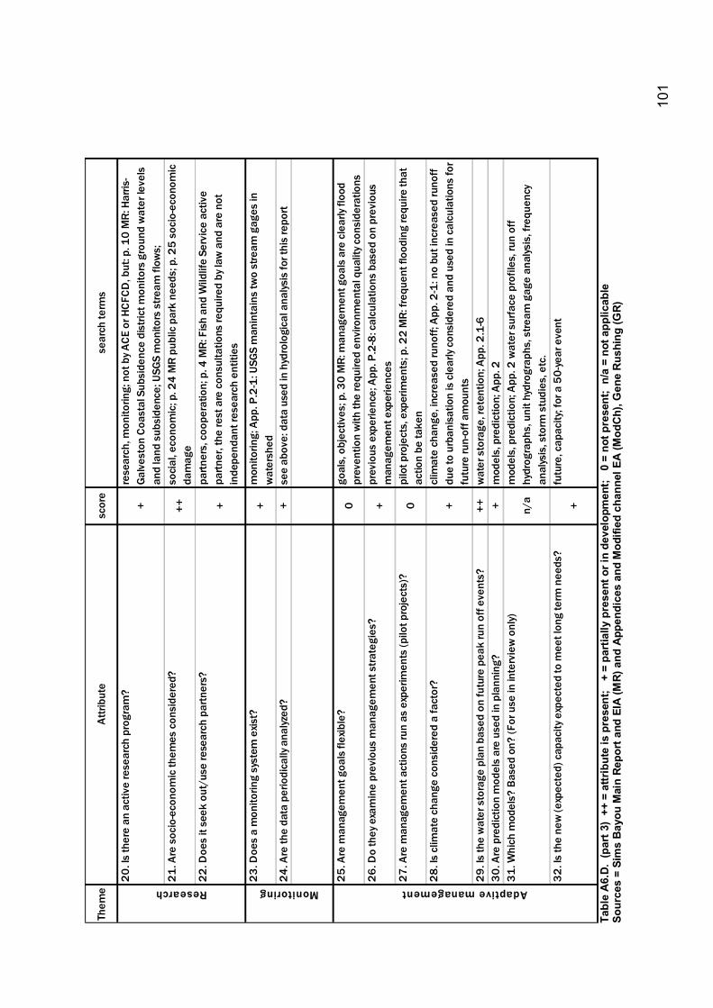
10
1
Them
e At
tribu
tesc
ore
sear
ch te
rms
20. I
s th
ere
an a
ctiv
e re
sear
ch p
rogr
am?
+re
sear
ch, m
onito
ring;
not
by A
CE o
r HCF
CD, b
ut: p
. 10
MR:
Har
ris-
Galv
esto
n Co
asta
l Sub
side
nce
dist
rict m
onito
rs g
roun
d w
ater
leve
ls
and
land
sub
side
nce;
USG
S m
onito
rs s
tream
flow
s;
21. A
re s
ocio
-eco
nom
ic th
emes
con
side
red?
++
soci
al, e
cono
mic
; p. 2
4 M
R pu
blic
par
k ne
eds;
p. 2
5 so
cio-
econ
omic
da
mag
e22
. Doe
s it
seek
out
/use
rese
arch
par
tner
s?+
partn
ers,
coo
pera
tion;
p. 4
MR:
Fis
h an
d W
ildlif
e Se
rvic
e ac
tive
partn
er, t
he re
st a
re c
onsu
ltatio
ns re
quire
d by
law
and
are
not
in
depe
ndan
t res
earc
h en
titie
s
23. D
oes
a m
onito
ring
syst
em e
xist?
+
mon
itorin
g; A
pp. P
.2-1
: USG
S m
anin
tain
s tw
o st
ream
gag
es in
w
ater
shed
24
. Are
the
data
per
iodi
cally
ana
lyzed
? +
see
abov
e: d
ata
used
in h
ydro
logi
cal a
nalys
is fo
r thi
s re
port
25. A
re m
anag
emen
t goa
ls fl
exib
le?
0go
als,
obj
ectiv
es; p
. 30
MR:
man
agem
ent g
oals
are
cle
arly
flood
pr
even
tion
with
the
requ
ired
envi
ronm
enta
l qua
lity c
onsi
dera
tions
26. D
o th
ey e
xam
ine
prev
ious
man
agem
ent s
trate
gies
?+
prev
ious
exp
erie
nce;
App
. P.2
-8: c
alcu
latio
ns b
ased
on
prev
ious
m
anag
emen
t exp
erie
nces
27. A
re m
anag
emen
t act
ions
run
as e
xper
imen
ts (p
ilot p
roje
cts)
?0
pilo
t pro
ject
s, e
xper
imen
ts; p
. 22
MR:
freq
uent
floo
ding
requ
ire th
at
actio
n be
take
n 28
. Is
clim
ate
chan
ge c
onsi
dere
d a
fact
or?
+cl
imat
e ch
ange
, inc
reas
ed ru
noff;
App
. 2-1
: no
but i
ncre
ased
runo
ff du
e to
urb
anis
atio
n is
cle
arly
cons
ider
ed a
nd u
sed
in c
alcu
latio
ns fo
r fu
ture
run-
off a
mou
nts
29. I
s th
e w
ater
sto
rage
pla
n ba
sed
on fu
ture
pea
k ru
n of
f eve
nts?
++w
ater
sto
rage
, ret
entio
n; A
pp. 2
.1-6
30. A
re p
redi
ctio
n m
odel
s ar
e us
ed in
pla
nnin
g?+
mod
els,
pre
dict
ion;
App
. 2
31. W
hich
mod
els?
Bas
ed o
n? (F
or u
se in
inte
rvie
w o
nly)
n/a
mod
els,
pre
dict
ion;
App
. 2 w
ater
sur
face
pro
files
, run
off
hydr
ogra
phs,
uni
t hyd
rogr
aphs
, stre
am g
age
anal
ysis
, fre
quen
cy
anal
ysis
, sto
rm s
tudi
es, e
tc.
32. I
s th
e ne
w (e
xpec
ted)
cap
acity
exp
ecte
d to
mee
t lon
g te
rm n
eeds
?+
futu
re, c
apac
ity; f
or a
50-
year
eve
nt
Research Monitoring Adaptive management
Ta
ble
A6.
D. (
part
3)
++ =
attr
ibut
e is
pre
sent
; +
= p
artia
lly p
rese
nt o
r in
deve
lopm
ent;
0 =
not
pre
sent
; n/
a =
not a
pplic
able
So
urce
s =
Sim
s B
ayou
Mai
n Re
port
and
EIA
(MR)
and
App
endi
ces
and
Mod
ified
cha
nnel
EA
(Mod
Ch)
, Gen
e R
ushi
ng (G
R)
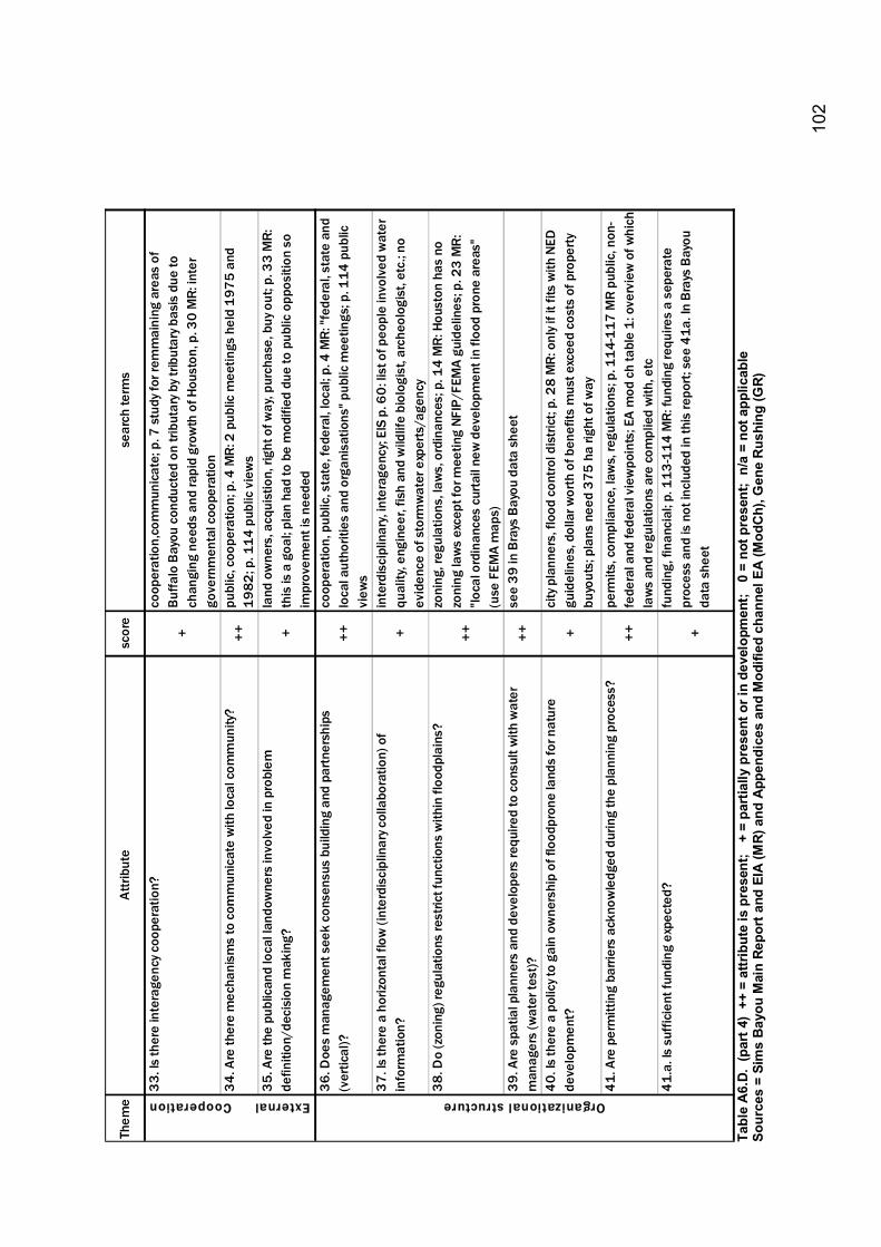
10
2
Them
e At
tribu
tesc
ore
sear
ch te
rms
33. I
s th
ere
inte
rage
ncy c
oope
ratio
n?
+
coop
erat
ion,
com
mun
icat
e; p
. 7 s
tudy
for r
emm
aini
ng a
reas
of
Buffa
lo B
ayou
con
duct
ed o
n tri
buta
ry b
y trib
utar
y bas
is d
ue to
ch
angi
ng n
eeds
and
rapi
d gr
owth
of H
oust
on, p
. 30
MR:
inte
r go
vern
men
tal c
oope
ratio
n 34
. Are
ther
e m
echa
nism
s to
com
mun
icat
e w
ith lo
cal c
omm
unity
? ++
publ
ic, c
oope
ratio
n; p
. 4 M
R: 2
pub
lic m
eetin
gs h
eld
1975
and
19
82; p
. 114
pub
lic v
iew
s35
. Are
the
publ
ican
d lo
cal l
ando
wne
rs in
volv
ed in
pro
blem
de
finiti
on/d
ecis
ion
mak
ing?
+
land
ow
ners
, acq
uist
ion,
righ
t of w
ay, p
urch
ase,
buy
out
; p. 3
3 M
R:
this
is a
goa
l; pl
an h
ad to
be
mod
ified
due
to p
ublic
opp
ositi
on s
o im
prov
emen
t is
need
ed36
. Doe
s m
anag
emen
t see
k co
nsen
sus
build
ing
and
partn
ersh
ips
(ver
tical
)?++
coop
erat
ion,
pub
lic, s
tate
, fed
eral
, loc
al; p
. 4 M
R: "f
eder
al, s
tate
and
lo
cal a
utho
ritie
s an
d or
gani
satio
ns" p
ublic
mee
tings
; p. 1
14 p
ublic
vi
ews
37. I
s th
ere
a ho
rizon
tal f
low
(int
erdi
scip
linar
y col
labo
ratio
n) o
f in
form
atio
n?
+in
terd
isci
plin
ary,
inte
rage
ncy;
EIS
p. 6
0: li
st o
f peo
ple
invo
lved
wat
er
qual
ity, e
ngin
eer,
fish
and
wild
life
biol
ogis
t, ar
cheo
logi
st, e
tc.;
no
evid
ence
of s
torm
wat
er e
xper
ts/a
genc
y38
. Do
(zon
ing)
regu
latio
ns re
stric
t fun
ctio
ns w
ithin
floo
dpla
ins?
++
zoni
ng, r
egul
atio
ns, l
aws,
ord
inan
ces;
p. 1
4 M
R: H
oust
on h
as n
o zo
ning
law
s ex
cept
for m
eetin
g NF
IP/F
EMA
guid
elin
es; p
. 23
MR:
"lo
cal o
rdin
ance
s cu
rtail
new
dev
elop
men
t in
flood
pro
ne a
reas
" (u
se F
EMA
map
s)39
. Are
spa
tial p
lann
ers
and
deve
lope
rs re
quire
d to
con
sult
with
wat
er
man
ager
s (w
ater
test
)?++
see
39 in
Bra
ys B
ayou
dat
a sh
eet
40. I
s th
ere
a po
licy t
o ga
in o
wne
rshi
p of
floo
dpro
ne la
nds
for n
atur
e de
velo
pmen
t?+
city
pla
nner
s, fl
ood
cont
rol d
istri
ct; p
. 28
MR:
onl
y if i
t fits
with
NED
gu
idel
ines
, dol
lar w
orth
of b
enef
its m
ust e
xcee
d co
sts
of p
rope
rty
buyo
uts;
pla
ns n
eed
375
ha ri
ght o
f way
41. A
re p
erm
ittin
g ba
rrier
s ac
know
ledg
ed d
urin
g th
e pl
anni
ng p
roce
ss?
++pe
rmits
, com
plia
nce,
law
s, re
gula
tions
; p. 1
14-1
17 M
R pu
blic
, non
-fe
dera
l and
fede
ral v
iew
poin
ts; E
A m
od c
h ta
ble
1: o
verv
iew
of w
hich
la
ws
and
regu
latio
ns a
re c
ompl
ied
with
, etc
41.a
. Is
suffi
cien
t fun
ding
exp
ecte
d?
+
fund
ing,
fina
ncia
l; p.
113
-114
MR:
fund
ing
requ
ires
a se
pera
te
proc
ess
and
is n
ot in
clud
ed in
this
repo
rt; s
ee 4
1a. I
n Br
ays
Bayo
u da
ta s
heet
Organizational structureExternalCooperation
Ta
ble
A6.
D. (
part
4)
++ =
attr
ibut
e is
pre
sent
; +
= p
artia
lly p
rese
nt o
r in
deve
lopm
ent;
0 =
not
pre
sent
; n/
a =
not a
pplic
able
So
urce
s =
Sim
s B
ayou
Mai
n Re
port
and
EIA
(MR)
and
App
endi
ces
and
Mod
ified
cha
nnel
EA
(Mod
Ch)
, Gen
e R
ushi
ng (G
R)
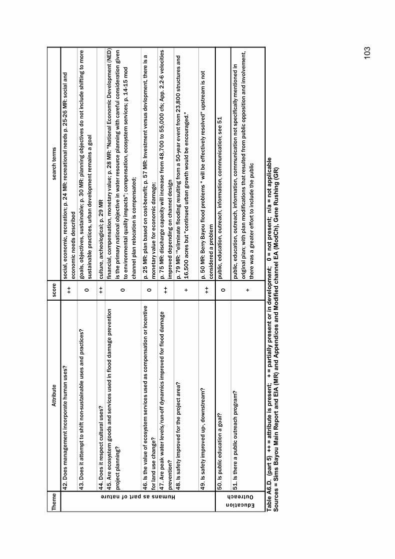
10
3
Them
e At
tribu
tesc
ore
sear
ch te
rms
42. D
oes
man
agem
ent i
ncor
pora
te h
uman
use
s?++
so
cial
, eco
nom
ic, r
ecre
atio
n; p
. 24
MR:
recr
eatio
nal n
eeds
p. 2
5-26
MR:
soc
ial a
nd
econ
omic
nee
ds d
escr
ibed
43. D
oes
it at
tem
pt to
shi
ft no
n-su
stai
nabl
e us
es a
nd p
ract
ices
?0
goal
s, o
bjec
tives
, sus
tain
able
; p. 3
0 M
R: p
lann
ing
obje
ctiv
es d
o no
t inc
lude
shi
fting
to m
ore
sust
aina
ble
prac
tices
, urb
an d
evel
opm
ent r
emai
ns a
goa
l
44. D
oes
it re
spec
t cul
tura
l use
s?
++cu
lture
, arc
heol
ogic
al; p
. 29
MR
45. A
re e
cosy
stem
goo
ds a
nd s
ervi
ces
used
in fl
ood
dam
age
prev
entio
n pr
ojec
t pla
nnin
g?0
finan
cial
, com
pens
atio
n, m
onet
ary v
alue
; p. 2
8 M
R: "N
atio
nal E
cono
mic
Dev
elop
men
t (NE
D)
is th
e pr
imar
y nat
iona
l obj
ectiv
e in
wat
er re
sour
ce p
lann
ing
with
car
eful
con
side
ratio
n gi
ven
to e
nviro
nmen
tal q
ualit
y im
pact
s"; c
ompe
nsat
ion,
eco
syst
em s
ervi
ces;
p. 1
4-15
mod
ch
anne
l pla
n re
loca
tion
is c
ompe
nsat
ed;
46. I
s th
e va
lue
of e
cosy
stem
ser
vice
s us
ed a
s co
mpe
nsat
ion
or in
cent
ive
for l
and
use
chan
ge?
0p.
25
MR:
pla
n ba
sed
on c
ost-b
enef
it; p
. 57
MR:
Inve
stm
ent v
ersu
s de
vlop
men
t, th
ere
is a
m
onet
ary v
alue
for e
cono
mic
dam
age;
47
. Are
pea
k w
ater
leve
ls/r
un-o
ff dy
nam
ics
impr
oved
for f
lood
dam
age
prev
entio
n?++
p. 7
5 M
R: d
isch
arge
cap
acity
will
incr
ease
from
48,
700
to 5
5,00
0 cf
s; A
pp. 2
.2-6
vel
ociti
es
impr
oved
dep
endi
ng o
n ch
anne
l des
ign
48. I
s sa
fety
impr
oved
for t
he p
roje
ct a
rea?
+p.
79
MR:
'"el
imin
ate
flood
ing
resu
lting
from
a 5
0-ye
ar e
vent
from
23,
800
stru
ctur
es a
nd
16,5
00 a
cres
but
"con
tinue
d ur
ban
grow
th w
ould
be
enco
urag
ed."
49. I
s sa
fety
impr
oved
up-
, dow
nstre
am?
++p.
50
MR:
Ber
ry B
ayou
floo
d pr
oble
ms
" will
be
effe
ctiv
ely r
esol
ved"
ups
tream
is n
ot
cons
ider
ed a
pro
blem
50. I
s pu
blic
edu
catio
n a
goal
? 0
publ
ic, e
duca
tion,
out
reac
h, in
form
atio
n, c
omm
unic
atio
n; s
ee 5
1
51. I
s th
ere
a pu
blic
out
reac
h pr
ogra
m?
+
publ
ic, e
duca
tion,
out
reac
h, in
form
atio
n, c
omm
unic
atio
n no
t spe
cific
ally
men
tione
d in
or
igin
al p
lan;
with
pla
n m
odifi
catio
ns th
at re
sulte
d fro
m p
ublic
opp
ositi
on a
nd in
volv
emen
t, th
ere
was
a g
reat
er e
ffort
to in
clud
e th
e pu
blic
Humans as part of nature Education Outreach
Ta
ble
A6.
D. (
part
5)
++ =
attr
ibut
e is
pre
sent
; +
= p
artia
lly p
rese
nt o
r in
deve
lopm
ent;
0 =
not
pre
sent
; n/
a =
not a
pplic
able
So
urce
s =
Sim
s B
ayou
Mai
n Re
port
and
EIA
(MR)
and
App
endi
ces
and
Mod
ified
cha
nnel
EA
(Mod
Ch)
, Gen
e R
ushi
ng (G
R)
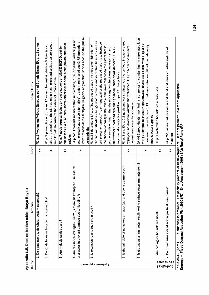
10
4
Appe
ndix
6.E
. Dat
a co
llect
ion
tabl
e: B
rays
Bay
ou
Them
e A
ttrib
ute
scor
ese
arch
term
s
1. D
o pl
ans
use
a w
ater
shed
, -sy
stem
app
roac
h?++
FD p
. 1 "w
ater
shed
"=Br
ays
Bay
ou a
s pa
rt of
Buf
falo
Bay
ou; E
A p
. 1-1
sam
e
2. D
o go
als
focu
s on
long
term
sus
tain
abili
ty?
+FD
p. 9
pro
ject
life
of 5
0 ye
ars;
EA
sear
ch fo
r sus
tain
abili
ty =
0; t
he d
istri
ct
sees
the
bene
fits
of th
e pl
an a
s m
ainl
y eco
nom
ic a
nd s
ocia
l, ec
olog
y pla
ys a
sm
alle
r rol
e be
caus
e of
the
exte
nt o
f urb
anis
atio
n
3. A
re m
ultip
le s
cale
s us
ed?
++FD
p. 7
goa
ls e
xpre
ss d
esire
s an
d ex
pect
atio
ns o
f USA
CE, H
CFCD
, pub
lic,
busi
ness
es; E
A p.
41
cum
ulat
ive
effe
cts
for f
eder
al, s
tate
, priv
ate
and
loca
l en
titie
s4.
Are
resi
lienc
e st
rate
gies
use
d? (I
s th
ere
an a
ttem
pt to
use
nat
ural
pr
oces
ses
to p
reve
nt d
amag
e du
e to
floo
ding
?)+
EA p
. 5-1
3 pr
even
t sed
imen
tatio
n an
d er
osio
n, p
. 3-6
"ch
anne
l wid
enin
g is
an
econ
omic
ally
attr
activ
e al
tern
ativ
e"; d
ente
ntio
n is
use
d se
e 5;
RF
mea
nder
s w
ere
not c
onsi
dere
d fo
r hyd
raul
ic g
oals
, onl
y ae
sthe
tics
and
beca
use
the
publ
ic
dem
ands
them
5. Is
reta
in, s
tore
and
then
dra
in u
sed?
+
FD p
. 11
dete
ntio
n; E
A 1
-1 T
he p
ropo
sed
actio
n in
clud
es a
com
bina
tion
of
chan
nel m
odifi
catio
ns, b
ridge
mod
ifica
tions
, and
det
entio
n ba
sins
as
wel
l as
soil
plac
emen
t are
as. T
he p
rimar
y go
al o
f the
pro
pose
d ac
tion
is to
incr
ease
th
e ch
anne
l cap
acity
in th
e m
iddl
e an
d lo
wer
reac
hes
to th
e ex
tent
that
is
econ
omic
ally
optim
um th
ereb
y red
ucin
g flo
odin
g fro
m h
eavy
rain
fall
and
stor
mw
ater
runo
ff an
d pr
even
ting
cons
eque
ntia
l flo
od d
amag
e.; p
. 5-1
2
impr
oved
dra
inag
e is
a p
ositi
ve im
pact
for b
rays
bay
ou
6. Is
the
prin
cipl
e of
no
adve
rse
impa
ct (u
p- a
nd d
owns
tream
) use
d?
++
FD p
. 8 a
nd E
A p
. 2-2
goa
ls a
nd c
onst
rain
ts: n
o ad
vers
e flo
od im
pact
cre
ated
by
pro
ject
; no
dive
rsio
n ou
tsid
e th
e w
ater
shed
; FD
p. 1
5 ad
vers
e im
pact
s do
wns
tream
mus
t be
addr
esse
d.
7. Is
gro
undw
ater
man
agem
ent l
inke
d to
sur
face
wat
er m
anag
emen
t?
+
EA 4
-22
grou
ndw
ater
mon
itorin
g is
ong
oing
for c
omta
min
ants
ass
ocia
ted
loca
l w
ith p
etro
chem
ical
indu
stry
; gro
undw
ater
leve
ls a
ssoc
iate
d w
ith p
roje
ct n
ot
men
tione
d. 'w
ater
tabl
e'=0
; EA
p. 8
-4 e
xcav
atio
n an
d fil
l will
not
adv
erse
ly im
pact
wat
er s
uppl
ies
8. A
re e
colo
gica
l bou
ndar
ies
used
?++
FD p
. 1 w
ater
shed
bou
ndar
ies
clea
rly u
sed
9. D
o bo
unda
ries
exte
nd a
cros
s po
litic
al b
ound
arie
s?++
EA p
. 2-1
wat
ersh
ed lo
cate
d in
For
t Ben
d an
d Ha
rris
cou
ntie
s an
d C
ity o
f H
oust
on
Systems approach Ecological boundaries
Ta
ble
A6.
E. (
part
1)
++ =
attr
ibut
e is
pre
sent
; +
= p
artia
lly p
rese
nt o
r in
deve
lopm
ent;
0 =
not
pre
sent
; n/
a =
not a
pplic
able
So
urce
s =
Flo
od D
amag
e R
educ
tion
Plan
200
0 (F
D);
Env.
Ass
essm
ent 2
006
(EA
); R
aouf
Far
id (R
F)
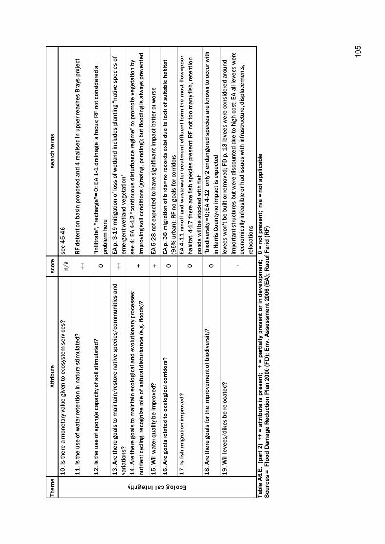
10
5
Them
e At
tribu
tesc
ore
sear
ch te
rms
10. I
s th
ere
a m
onet
ary v
alue
giv
en to
eco
syst
em s
ervi
ces?
n/a
see
45-4
6
11. I
s th
e us
e of
wat
er re
tent
ion
in n
atur
e st
imul
ated
?++
RF d
eten
tion
basi
n pr
opos
ed a
nd 4
real
ised
in u
pper
reac
hes
Bray
s pr
ojec
t
12. I
s th
e us
e of
spo
nge
capa
city
of s
oil s
timul
ated
?0
"infil
trate
", "r
echa
rge"
= 0;
EA
1-1
drai
nage
is fo
cus;
RF
not c
onsi
dere
d a
prob
lem
her
e
13. A
re th
ere
goal
s to
mai
ntai
n/re
stor
e na
tive
spec
ies/
com
mun
ities
and
va
riatio
ns?
++EA
p. 3
-19
miti
gatio
n of
loss
of w
etla
nd in
clud
es p
lant
ing
"nat
ive
spec
ies
of
emer
gent
wet
land
veg
etat
ion"
14. A
re th
ere
goal
s to
mai
ntai
n ec
olog
ical
and
evo
lutio
nary
pro
cess
es:
nutri
ent c
yclin
g, re
cogn
ize ro
le o
f nat
ural
dis
turb
ance
(e.g
. flo
ods)
?+
see
4; E
A 4-
12 "c
ontin
uous
dis
turb
ance
regi
me"
to p
rom
ote
vege
tatio
n by
im
prov
ing
soil
cond
ition
s (g
razin
g, p
ondi
ng);
but f
lood
ing
is a
lway
s pr
even
ted
15. W
ill w
ater
qua
lity b
e im
prov
ed?
+EA
5-2
8 no
t exp
ecte
d to
hav
e si
gnifi
cant
impa
ct b
ette
r or w
orse
16. A
re g
oals
rela
ted
to e
colo
gica
l cor
ridor
s?0
EA p
. 38
mig
ratio
n of
bird
s=no
reco
rds
exis
t due
to la
ck o
f sui
tabl
e ha
bita
t (9
5% u
rban
); RF
no
goal
s fo
r cor
ridor
s17
. Is
fish
mig
ratio
n im
prov
ed?
0EA
4-1
1 ru
noff
and
was
tew
ater
trea
tmen
t effl
uent
form
the
mos
t flo
w=p
oor
habi
tat,
4-17
ther
e ar
e fis
h sp
ecie
s pr
esen
t; RF
not
too
man
y fis
h, re
tent
ion
pond
s w
ill b
e st
ocke
d w
ith fi
sh18
. Are
ther
e go
als
for t
he im
prov
emen
t of b
iodi
vers
ity?
0"b
iodi
vers
ity'=
0; E
A 4-
12 o
nly 2
end
ange
red
spec
ies
are
know
n to
occ
ur w
ith
in H
arris
Cou
nty-n
o im
pact
is e
xpec
ted
19. W
ill le
vees
/dik
es b
e re
loca
ted?
+
leve
es w
on't
be b
uilt
or re
mov
ed; F
D p
. 13
leve
es w
ere
cons
ider
ed a
roun
d im
porta
nt s
truct
ures
but
wer
e di
scou
nted
due
to h
igh
cost
; EA
all l
evee
s w
ere
econ
omic
ally
infe
asib
le o
r had
issu
es w
ith in
frast
ruct
ure,
dis
plac
emen
ts,
relo
catio
ns
Ecological integrity
Ta
ble
A6.
E. (
part
2)
++ =
attr
ibut
e is
pre
sent
; +
= p
artia
lly p
rese
nt o
r in
deve
lopm
ent;
0 =
not
pre
sent
; n/
a =
not a
pplic
able
So
urce
s =
Flo
od D
amag
e R
educ
tion
Plan
200
0 (F
D);
Env.
Ass
essm
ent 2
006
(EA
); R
aouf
Far
id (R
F)
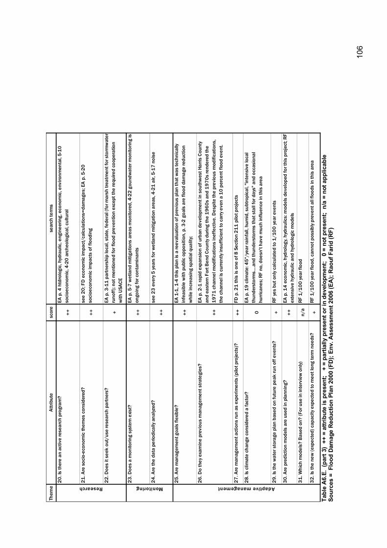
10
6
Them
e At
tribu
tesc
ore
sear
ch te
rms
20. I
s th
ere
an a
ctiv
e re
sear
ch p
rogr
am?
++
EA p
. 4 h
tdro
logi
c, h
ydra
ulic
, eng
inee
ring,
eco
nom
ic, e
nviro
nmen
tal,
5-10
so
cioe
cono
mic
, 4-2
0 ar
cheo
logi
cal,
cultu
ral
21. A
re s
ocio
-eco
nom
ic th
emes
con
side
red?
++
see
20; F
D e
cono
mic
impa
ct/c
alcu
latio
ns=d
amag
es; E
A p.
5-2
0 so
cioe
cono
mic
impa
cts
of fl
oodi
ng
22. D
oes
it se
ek o
ut/u
se re
sear
ch p
artn
ers?
+
EA p
. 3-1
1 pa
rtner
ship
loca
l, st
ate,
fede
ral (
for m
arsh
trea
tmen
t for
sto
rmw
ater
ru
noff)
; not
men
tione
d fo
r flo
od p
reve
ntio
n ex
cept
the
requ
ired
coop
erat
ion
with
USA
CE
23. D
oes
a m
onito
ring
syst
em e
xist?
++
EA p
. 5-7
wet
land
miti
gatio
ns a
reas
mon
itore
d, 4
-22
goun
dwat
er m
onito
ring
is
ongo
ing
for c
onta
min
ants
24. A
re th
e da
ta p
erio
dica
lly a
nalyz
ed?
++
see
23 e
very
5 ye
ars
for w
etla
nd m
itiga
tion
area
s, 4
-21
air,
5-17
noi
se
25. A
re m
anag
emen
t goa
ls fl
exib
le?
++
EA 1
-1, 1
-4 th
is p
lan
is a
reev
alua
tion
of p
revi
ous
plan
that
was
tech
nica
lly
infe
asib
le w
ith p
ublic
opp
ositi
on, p
. 3-2
goa
ls a
re fl
ood
dam
age
redu
ctio
n w
hile
incr
easi
ng s
patia
l qua
lity;
26. D
o th
ey e
xam
ine
prev
ious
man
agem
ent s
trate
gies
?
++
EA p
. 2-1
rapi
d ex
pans
ion
of u
rban
dev
elop
men
t in
sout
hwes
t Har
ris C
ount
y an
d ea
ster
n Fo
rt Be
nd C
ount
y dur
ing
the
1960
s an
d 19
70s
rend
ered
the
1971
cha
nnel
mod
ifica
tions
inef
fect
ive.
Des
pite
the
prev
ious
mod
ifica
tions
, th
e ch
anne
l is
curre
ntly
insu
ffici
ent t
o ca
rry e
ven
a 10
per
cent
floo
d ev
ent.
27. A
re m
anag
emen
t act
ions
run
as e
xper
imen
ts (p
ilot p
roje
cts)
?++
FD p
. 21
this
is o
ne o
f 8 S
ectio
n 21
1 pi
lot p
roje
cts
28. I
s cl
imat
e ch
ange
con
side
red
a fa
ctor
?
0
EA p
. 19
clim
ate:
45"
/yea
r rai
nfal
l, hu
mid
, sub
tropi
cal,
"inte
nsiv
e lo
cal
thun
ders
torm
s�.a
nd th
unde
rsto
rms
that
sta
ll fo
r day
s" a
nd o
ccas
iona
l hu
rrica
nes;
RF
no, d
oesn
't ha
ve m
uch
influ
ence
in th
is a
rea
29. I
s th
e w
ater
sto
rage
pla
n ba
sed
on fu
ture
pea
k ru
n of
f eve
nts?
+RF
yes
but o
nly c
alcu
late
d to
1/1
00 ye
ar e
vent
s
30. A
re p
redi
ctio
n m
odel
s ar
e us
ed in
pla
nnin
g?++
EA p
. 14
econ
omic
, hyd
rolo
gy, h
ydra
ulic
s: m
odel
s de
velo
ped
for t
his
proj
ect;
RF
exte
nsiv
e hy
drau
lic a
nd h
ydro
logi
c m
odel
s
31. W
hich
mod
els?
Bas
ed o
n? (F
or u
se in
inte
rvie
w o
nly)
n/a
RF 1
/100
year
floo
d
32. I
s th
e ne
w (e
xpec
ted)
cap
acity
exp
ecte
d to
mee
t lon
g te
rm n
eeds
?+
RF 1
/100
year
floo
d, c
anno
t pos
sibl
y pre
vent
all
flood
s in
this
are
a
Research Monitoring Adaptive management
Ta
ble
A6.
E. (
part
3)
++ =
attr
ibut
e is
pre
sent
; +
= p
artia
lly p
rese
nt o
r in
deve
lopm
ent;
0 =
not
pre
sent
; n/
a =
not a
pplic
able
So
urce
s =
Flo
od D
amag
e R
educ
tion
Plan
200
0 (F
D);
Env.
Ass
essm
ent 2
006
(EA
); R
aouf
Far
id (R
F)
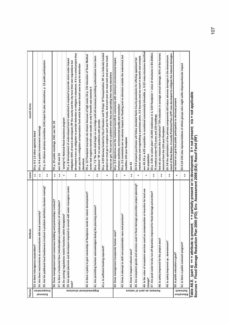
10
7
Them
e At
tribu
tesc
ore
sear
ch te
rms
33. I
s th
ere
inte
rage
ncy c
oope
ratio
n?++
EA p
. 6-1
13
othe
r age
ncie
s lis
ted
34. A
re th
ere
mec
hani
sms
to c
omm
unic
ate
with
loca
l com
mun
ity?
++EA
p. 6
-4 p
ublic
invo
lvem
ent m
eetin
gs
35. A
re th
e pu
blic
and
loca
l lan
dow
ners
invo
lved
in p
robl
em d
efin
ition
/dec
isio
n m
akin
g?
++FD
p. 1
4 ci
tizen
s ad
viso
ry c
omm
ittee
(CAC
)-inp
ut fo
r pla
n al
tern
ativ
es, p
. 19
publ
ic p
artic
ipat
ion
36. D
oes
man
agem
ent s
eek
cons
ensu
s bu
ildin
g an
d pa
rtner
ship
s (v
ertic
al)?
++FD
p. 1
9 pu
blic
mee
tings
, CAC
; see
34,
35
37. I
s th
ere
a ho
rizon
tal f
low
(int
erdi
scip
linar
y col
labo
ratio
n) o
f inf
orm
atio
n?
++se
e 30
and
33
38. D
o (z
onin
g) re
gula
tions
rest
rict f
unct
ions
with
in fl
oodp
lain
s?+
'zon
ing'
=0; N
atio
nal f
lood
insu
ranc
e pr
ogra
m
39. A
re s
patia
l pla
nner
s an
d de
velo
pers
requ
ired
to c
onsu
lt w
ith w
ater
man
ager
s (w
ater
te
st)?
++
FD p
. 8 d
evel
opm
ent o
f und
evel
oped
land
in w
ater
shed
is re
quire
d to
pro
vide
sto
rm w
ater
impa
ct
miti
gatio
n (9
5% o
f lan
d is
dev
elop
ed);
RF
the
coun
ty a
nd th
e ci
ty h
ave
thei
r ow
n re
gula
tions
but
de
velo
pers
hav
e an
obl
igat
ion
to p
rovi
de d
eten
tion
or m
itiga
te it
els
ewhe
re. I
f it i
s a
smal
l pro
ject
they
ca
n pa
y int
o a
miti
gatio
n co
mpe
nsat
ion
fund
whi
ch th
e w
ater
boa
rd u
ses
to p
ay fo
r det
entio
n el
sew
here
40. I
s th
ere
a po
licy
to g
ain
owne
rshi
p of
floo
dpro
ne la
nds
for n
atur
e de
velo
pmen
t?+
FD p
. 12
Floo
dpla
in b
uy-o
uts
nto
chos
en b
ecau
se o
f hig
h co
sts;
EA
p. 3
-8 re
loca
tion
of T
exas
Med
ical
ce
nter
had
neg
ativ
e be
nefit
cos
t res
ults
so
only
if b
enef
it co
st w
arra
nts
it
41. A
re p
erm
ittin
g ba
rrier
s ac
know
ledg
ed d
urin
g th
e pl
anni
ng p
roce
ss?
++EA
p. 7
-2 "N
o w
ork
shal
l beg
in o
n an
y brid
ge u
ntil
all n
eces
sary
per
mitt
ing
auth
oriza
tions
hav
e be
en
obta
ined
." R
F no
real
pro
blem
s w
ith p
erm
its41
.a. I
s su
ffici
ent f
undi
ng e
xpec
ted?
+
EA p
. 4-2
9 bi
kew
ay fu
nded
by C
ity o
f Hou
ston
and
TX
Dep
t. Of
Tra
nspo
rtat
ion;
RF
as a
fede
rally
fund
ed
proj
ect w
e m
ust g
o to
con
gres
s ea
ch ye
ar fo
r fun
ds. A
nd e
ach
year
we
mus
t wai
t and
see
how
muc
h m
oney
we
get.
That
can
be
a pr
oble
m w
hen
they
are
spe
ndin
g th
eir m
oney
els
ewhe
re
42. D
oes
man
agem
ent i
ncor
pora
te h
uman
use
s?++
EA p
. 2-2
obj
ectiv
es a
re th
e m
axim
um b
enef
it to
com
mun
ity w
ith m
inim
um e
nviro
nmen
tal i
mpa
ct,
enha
nce
aest
hetic
s, e
nviro
nmen
tal q
ualit
y an
d re
crea
tion
43. D
oes
it at
tem
pt to
shi
ft no
n-su
stai
nabl
e us
es a
nd p
ract
ices
?+
EA p
. 2-2
con
stra
ints
are
no
adve
rse
impa
ct o
n flo
odin
g an
d no
div
ersi
on o
utsi
de th
e w
ater
shed
; but
m
odifi
es 1
00 ye
ar fl
oodp
lain
44. D
oes
it re
spec
t cul
tura
l use
s?
++se
e 42
45. A
re e
cosy
stem
goo
ds a
nd s
ervi
ces
used
in fl
ood
dam
age
prev
entio
n pr
ojec
t pla
nnin
g?+
EA 6
-6 p
rope
rty p
urch
ases
will
follo
w s
tand
ard
Harri
s Co
unty
pro
cedu
res
for o
fferin
g ap
prai
sed
fair
mar
ket v
alue
s an
d ne
gotia
ting
a pu
rcha
se p
rice,
3-2
buy
-out
s co
st to
o m
uch
in b
enef
it co
st a
nalys
is
46. I
s th
e va
lue
of e
cosy
stem
ser
vice
s us
ed a
s co
mpe
nsat
ion
or in
cent
ive
for l
and
use
chan
ge?
+se
e 45
; EA
p. 4
-29
acq
uisi
tion
is c
onsi
dere
d ec
onom
ical
ly in
feas
ible
, p. 5
-22
man
y stru
ctur
es id
entif
ied
for a
cqui
sitio
n47
. Are
pea
k w
ater
leve
ls/r
un-o
ff dy
nam
ics
impr
oved
for f
lood
dam
age
prev
entio
n?++
EA p
. 4-2
6 no
act
ion
plan
= 16
,000
resi
denc
es in
1/1
00 fl
oodp
lain
= v
alue
of s
truct
ures
is $
4.2b
illio
n,
TX m
edic
al c
ente
r=67
5 ac
res
and
100
bui
ldin
gs48
. Is
safe
ty im
prov
ed fo
r the
pro
ject
are
a?++
how
do
you
mea
sure
this
in h
ydra
ulic
s? 7
5% re
duct
ion
in a
vera
ge a
nnua
l dam
age,
90
% o
f the
hom
es
rem
oved
from
the
100
year
floo
dpla
in49
. Is
safe
ty im
prov
ed u
p-, d
owns
tream
?++
EA 3
-8 th
e op
timiza
tion
of th
e pr
imar
y com
pone
nts
did
indu
ce a
dver
se d
amag
es in
the
dow
nstre
am
reac
h of
Bra
ys B
ayou
. A L
ocal
ly Pr
efer
red
Plan
(LPP
) was
dev
elop
ed to
miti
gate
the
indu
ced
dam
ages
.50
. Is
publ
ic e
duca
tion
a go
al?
+no
t lis
ted
as a
goa
l but
pub
lic p
artic
ipat
ion
is o
bvio
usly
pres
ent
51. I
s th
ere
a pu
blic
out
reac
h pr
ogra
m?
++EA
5-1
9 CA
C-al
so re
pres
enta
tions
of e
thni
c gr
oups
who
mig
ht s
uffe
r dis
prop
ortio
nate
impa
ct
Education Outreach
External Cooperation Organisational structure Humans as part of nature
Ta
ble
A6.
E. (
part
4)
++ =
attr
ibut
e is
pre
sent
; +
= p
artia
lly p
rese
nt o
r in
deve
lopm
ent;
0 =
not
pre
sent
; n/
a =
not a
pplic
able
So
urce
s =
Flo
od D
amag
e R
educ
tion
Plan
200
0 (F
D);
Env.
Ass
essm
ent 2
006
(EA
); R
aouf
Far
id (R
F)

10
8

109
Appendix 7 Interview transcripts Appendix 7.A. Dynamisch Beekdal: Interview with project manager Bart Pastor Appendix 7.B. Tongelreep: Interview with project manager Marcel van Betuw Appendix 7.C. Hondsbroeksche Pleij: Interview with project manager Henk Eerden Appendix 7.D. Sims Bayou: Interview with project manager Gene Rushing Appendix 7.E. Brays Bayou: Interview with project manager Raouf Farid

110
111
Appendix 7.A. Dynamisch Beekdal: Interview transcript: project manager Bart Pastor Interview of: Bart Pastor, Project manager Dynamisch Beekdal 17 januari 2007 By: Kathy Becker Transcript reviewed and revised by Bart Pastor 22 January 2007 Vraag (V): Vindt u het goed als ik dit opneem? Antwoord (A): Ja, als het maar niet op de radio komt! V: Heb je mijn inforpakket gelezen A: wel genoeg om een idee te krijgen van wat er verwacht wordt met de interview V: Met dit plan (Koepelplan Dyn. Beekdal) heb ik de framework afgelopen en die kwam met een 10 uit de bus. A: een tevreden lach V: Dus de vragen die ik heb gaan over dingen die niet in het plan te vinden zijn zoals monitoren A: moeilijk verhaal: je hebt twee typen monitoren relevant voor het project:
• Beleidsmonitoring; meet de mate waarin door de inrichtingsvorm beleiddoelstellingen worden bereikt (denkend aan waterbergingsdoelstellingen en ecologische doelstellingen)
• Monitoren neveneffecten (met name de gevolgen van met name de waterbergingscomponent op gebruikersfuncties landbouw (frequentie, duur en mate van overstroming), wonen (onderlopen kelders, huizen, tuinen), natuur (gevolgen verandering waterhuishouding op bestaande natuur). Met andere woorden zijn de gevolgen gelijk, minder of erger dan verwacht. Wij zeggen bv woningen beschermd zijn en dingen zoals kelders die bij woningen horen geen schade zullen krijgen. Dus wat wij doen is in feite de nul situatie opnemen zodat als er schade ontstaat in de toekomst, dan kunnen we dat vergelijken met de nul situatie en kunnen zien of de schade te relateren is aan dit project. Nul situatie moet in samenwerking met de mensen die een belang hebben in het gebied, ze moeten er achter staan, anders heeft het geen zin en krijg je later er ook problemen mee.
Voor beleidsdoel monitoring loopt het stroef, eigenlijk moeten we nu de nul situatie meten Voor grondwater: er wordt grondwater gemeten, maar heel grofmazig (3 punten) waterstanden hebben we wel, maar grondwater niet. De grondwater gegevens bank (TNO) bestaat wel, maar gegevens zijn vaak te ver weg van project grenzen (in dit geval 150 m van beek af) en dus niet van toepassing op beekdal zelf. Dus dat kan beter, maar gaat door de waterschap niet opgepakt worden. V: Is de SOBEK model gekoppeld aan grondwaterstanden. A: nee, alleen oppervlakte water. Sobek meet alleen bakprofiel. Deze model heeft over-land flow ook gebruikt. Ze hebben er ook zo voor gekozen voor een ander middel omdat ook het doel is veranderd. Eerste intentie was blauwe diensten ontwikkelen. Naar de boer toe om op perceelniveau een overeenkomst te sluiten betreffende jaarlijkse vergoeding op basis van statistische (statistische) frequentieberekening van overstroming. De frequentie is in hoge mate bepalend voor de hoogte van de schadevergoeding. Vandaar dat destijds ook hele hoge kwaliteitseisen aan het model werden gesteld (Sobek vertaald in SIMGRO; zodoende werd de grondwatercomponent meegenomen in het model). Toen werden de ontwikkeling blauwe diensten gestopt omdat dit gevoelig zou zijn voor verkapte staatssteun. Vergoedingsstelsel wat nu in ontwikkeling is gebaseerd op schadebetaling achteraf: eerst schade en daarna pas betalen. Dus nu is de exacte bepaling van de frequentie minder van belang (orde van grote voldoet in deze). Doorde grote problemen die onstonden in de omzetting van de sobekgegevens in simgro is gekozen voor een alternatief Sobek Overland V: De blauwe diensten dan, waarom zijn die niet van de grond gekomen? A:Gevoeligheid voor verkapte staatssteun A: Parallel aan dit inrichtingsplan is de juridische instrumentarium waterberging gekomen. Wij zijn de eerste waterschap die ook een keurkaart hebben. Dynamisch beekdal is opgenomen in de keurkaart als plangrens. Dus heeft het gebied functie waterberging. Dan is het ook niet nodig om te zeggen hoe vaak het nat zal zijn; functie waterberging, punt. Dus is de T100 lijn gebruikt voor afgrenzing.
112
V: Terug naar monitoring, chemische kwaliteit van het water? A: wordt gedaan in een reguliere waterkwaliteitsmonitoring programma van de waterschap. Er zijn ook 3 riooloverstoorten in het gebied en die worden ook aangepakt. Hoe weten we nog niet. V: ivm KRW doelen? A: Plan is getoets of het tegenstrijdig is met KRW doelen. En alles wat we nu doen is of een positief of neutraal verandering mbt waterkwaliteit. Vis migratie is terug gebracht, dynamiek is terug, etc. Wel wat natuur wordt ingeleverd bv van bij het kasteel. Dat verandert met de tijd eerst achteruit en daarna bouwt het zich weer op. De natte natuurparel bij het kasteel is tegenstrijdig. Dynamiek vs. Peilverhoging (vernatting) en waterschap vs. Provincie. Dit moet nog opgelost worden, maar ik heb het idee dat wij gaan winnen (dus dynamiek) V: De natuurdoeltypes discussie speelt hier ook een rol in? A: De natuurdoeltype discussie is een stempel boven op de natte natuur parel die eigenlijk anti-verdroging doelstellingen heeft. BP zegt dat het geen doel moet zijn-anti-verdroging. Je moet een bepaalde ecosysteem nastreven en daar is je waterhuishouding op aangepast. En voor een beek is dat dynamiek en niet vernatting. V: Er wordt over een bermsloot gesproken in het plan; gaat dat de oplossing worden van de waterpeil conflicten? A: Ja, dat zou kunnen want zo werkt het ook nu. Bermsloot vormt een buffer. Dus we kunnen kijken of we het weer ergens kunnen maken of profiel aanpassingen of een onderwater stuw. V: Interessant is toch die tegenstrijdigheden tussen provincie, Brabantse landschap en waterschap. Iedereen wil natuur en iets moois maken, maar toch zijn er verschillen in hoe of wat. A: Dat moet met de inrichtingsplan opgelost worden. Of met dynamisch beekdal of natte natuur parel of iets tussenin. V: De factor tijd lijkt mij ook een bedreiging voor lange termijn. Want dit plan is maar het begin en daar is al heel veel tijd ingegaan. Inrichtingsplannen moeten nog komen. A: Ja en toch zeg ik dat we niet genoeg tijd krijgen voor het maken van de plannen. Je moet dat ook in context van subsidies zien. Daar loop je ook achteraan omdat dat moet. Maar eigenlijk moet je gewoon die laten liggen totdat je zoals met dit plan zover bent. Dan pas subsidies gaan regelen: want een goed project krijgt financiering. Want nu heb ik eigenlijk Nofdp geld niet meer nodig. Ik heb zoveel andere subsidies binnen gekregen. (subsidie gebiedsgericht beleid (SGB)-reconstructie wet, CORK, eu). Tevens heb ik geld misgelopen doordat bijdragen van donoren in een vroeg stadium vaak gebaseerd zijn op optimistische ramingen. Dus dat is wel een les: eerst je eigen investering in ontwerpfase, namelijk het plan maken, daarna pas subsidies aanvragen op de bedragen in het plan. V: Blauw/groene diensten struikelblok is de EU geweest? A: Ja en ook eigenlijk de LNV. LNV durfde het niet aan om die regeling (vooraf een regeling treffen) aan te vragen want dat wordt gezien als een subsidie voor boeren waar wij als EU vanaf willen/moeten. V: Ik zag grondverwerving als een bedreiging waar veel van het plan van afhankelijk is. Wat verwacht je? A: Van daar dat we het plan gebied hebben aangewezen als waterbergingsgebied met de juridische instrumentarium keurkaart. Dus als dat proces is doorlopen kunnen we de dijken weghalen en kunnen we altijd de waterbergingsdoelstellingen halen. Of we dan de ecologische doelstellingen dan halen blijft de vraag. Maar volgens mij is het dan gewoon een kwestie van de dijken weghalen en dan heeft de boer zoveel last van hoogwater dat hij de grond wel kwijt wil. V: Heb je kijk op hoe lang dat gaat duren? A: Rechtsom of linksom gaat het gebeuren maar tijdspad?? Loigt er ook aan hoe hard het waterschap wil inzetten (dijken gewoon weghalen of in overeenstemming). Dat is een nog door te lopen proces waar ik ook nog geen kijk op heb. Aanliggende gronden voor meander Assendelft zijn al verworven en over een maand heb ik een uitvoeringsplan wat de inspraak zal ingaan. Het kasteel komt er ook aan, maar daarna? Er zijn ook veel bezwaren. De boeren zijn flink bezig met juridische adviezen enzovoorts. Dus als ze een bezwaar hebben wat we niet kunnen weerleggen dan kan het heel lang duren.
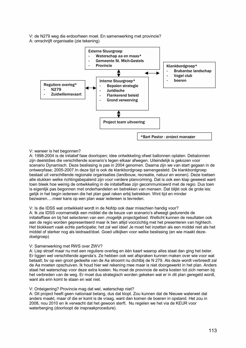
113
V: de N279 weg die erdoorheen moet. En samenwerking met provincie? A: omschrijft organisatie (zie tekening)
V: waneer is het begonnen? A: 1998-2004 is de initatief fase doorlopen; idee ontwikkeling ofwel ballonnen oplaten. Debalonnen zijn deelstdies die verschillende scenario�s tegen elkaar afwegen. Uiteindelijk is gekozen voor scenario Dynamisch. Deze beslissing is pas in 2004 genomen. Daarna zijn we van start gegaan in de ontwerpfase; 2005-2007.In deze tijd is ook de klankbordgroep samengesteld. De klankbordgroep bestaat uit verschillende regionale organisaties (landbouw, recreatie, natuur en wonen). Deze toetsen alle stukken welke richtingsbepalend zijn voor verdere planvorming. Dat is ook een klap geweest want toen bleek hoe weinig de ontwikkeling in de initatieffase zijn gecommuniceerd met de regio. Dus toen is eigenlijk pas begonnen met onderhandelen en betrekken van mensen. Dat blijkt ook de grote les: gelijk in het begin iedereen die het plan gaat raken erbij betrekken. Wint tijd en minder bezwaren�.meer kans op een plan waar iedereen is tevreden. V: Is die IDSS wat ontwikkeld wordt in de Nofdp ook daar misschien handig voor? A: Ik zie IDSS voornamelijk een middel die de keuze van scenario�s afweegt gedurende de initatieffase en bij het selecteren van een ,mogelijk projectgebied. Wellicht kunnen de resultaten ook aan de regio worden gepresenteerd maar ik ben altijd voorzichtig met het presenteren van hightech. Het blokkeert vaak echte participatie; het zal wel idee! Je moet het inzetten als een middel niet als het middel of sterker nog als leidraad/doel. Goed uitkijken voor welke beslissing (en wie maakt deze-doelgroep) V: Samenwerking met RWS over ZWV? A: Liep stroef maar nu met een reguliere overleg en één kaart waarop alles staat dan ging het beter. Er liggen wel verschillende agenda�s. Ze hebben ook wel afspraken kunnen maken over wie voor wat betaalt; bv op een groot gedeelte van de Aa stroomt nu dichtbij de N 279. Als deze wordt verbreedt zal de Aa moeten opschuiven. Ik houd hier wel rekening mee maar is niet doorgewerkt in het plan. Anders staat het waterschap voor deze extra kosten. Nu moet de provincie de extra kosten tot zich nemen bij het verbreden van de weg. Er moet dus strategisch worden gekeken wat er in dit plan geregeld wordt, want als erin komt te staan en wat niet. V: Onteigening? Provincie mag dat wel, waterschap niet? A: Dit project heeft geen nationaal belang, dus dat klopt. Zou kunnen dat de Nieuwe waterwet dat anders maakt, maar of die er komt is de vraag, want dan komen de boeren in opstand. Het zou in 2008, nou 2010 en ik verwacht dat het gewoon sterft. Nu regelen we het via de KEUR voor waterberging (doorloopt de inspraakprocedure).
Externe Stuurgroep- Waterschap aa en maas* - Gemeente St. Mich-Gestels - Provincie
Interne Stuurgroep*- Bepalen strategie - Juridische - Flankerend beleid - Grond verwerving
*Bart Pastor - project manager
Klankbordgroep* - Brabantse landschap- Vogel club - boeren
Reguliere overleg* - N279 - Zuidwillemsvaart
Project team uitvoering
114
Appendix 7.B. Tongelreep: Interview transcript: project manager Marcel van Betuw Interview of: Marcel van Betuw, Project manager Herinrichting Tongelreepdal, Waterschap De Dommel, Boxtel Netherlands By: Kathy Becker Transcript reviewed and revised by Marcel van Betuw 24 January 2007 Vraag (V): Vindt u het goed als ik dit opneem? Antwoord (A): ja V: Eerste vraag gaat over het watersysteem benadering. IK probeer dit plan in een groter verband te plaatsen. Is er een ander plan? A: Waterbeheersplan waarin functies ook staan. De aanleiding voor dit project is dat de huidige inrichting van de Tongelreepdal niet aansluit op de functie toewijzing in het waterbeheersplan en daar moet het waterschap wat aan doen. Ook in de reconstructieplannen (Reconstructie plan Bovendommel) is ook gekeken naar het stroomgebied van de Tongelreep. Daarin is vastgesteld dat omdat het veel EHS gebieden bevatte en dat het een soort natuurbeek moest worden. Recon. Plan bovendommel geeft ook aan dat de Tongelreepdal heringericht moet worden. Provincie heeft ook beek en kreekherstel verhaal, maar dat is meer een programma van eisen van hoe een beek of kreek eruit moet zien (referentie). Ook een strategische visie van watershap. V: Dit project is eind jaren 90 opgestart. Waneer is de Nofdp erin gekomen? A: Er zijn twee lijnen eigenlijk. De herinrichting Tongelreep zelf en dan de subsidie aanvragen (Nofdp) die parallel lopen en moet afzonderlijk bekeken worden. V: Groen/blauwe diensten zijn zover ik kon zien nvt. Klopt dat? A: Klopt en dat zal ik uitleggen. Die groen/blauwe diensten heb je alleen nodig waneer je water moet parkeren en dat op agrarisch grond moet plaatsvinden. Dat gebeurt hier niet omdat water in viskweekvijvers wordt geparkeerd. Wel wil ik zeggen dat waterschap De Dommel hoopt dat g/b diensten wel een succes wordt omdat we weten dat er 1000ha waterbergingsgebied moet worden gevonden binnen een waterschap die 152,000ha groot is. En we weten dat we dat 1000ha niet gaan aankopen. Wat betekent dat we een overeenkomst moet krijgen met de eigenaren. Er zijn ook modellen opgesteld van hoe dat proces opgestart moet worden en er is uitgerekend hoe de vergoeding berekend gaat worden. Er wordt wel voor schade vergoed, maar dan achteraf jaarlijks wordt er gekeken wat de schade is en wordt er uitbetaald. Er zijn gewoon nog weinig ervaringen. V: Hoe wordt de vergoeding berekend? A: Hangt ervan af, gewas schade kan daarop berekend worden; maar vermogensschade of planschade (bv waneer het gebied in bestemmingsplannen aangeduid is met de functie waterberging dat gevolgen heeft voor de waarde van de grond, etc). Deze discussie is ook een van de redenen waarom het nog niet op groots omarmd wordt. DVD: Duurzame watersystemen: experimenteren met waterbeheer laat een pilot project zien waarin overeenkomsten zijn gesloten. (Perry van Kempen, Louis Vrings Interreg IIIa) V: Groene/blauwe diensten zijn dus wel in ontwikkeling? A: Ja, je mag niet van te voren met een afkoopsom komen. V: Onderzoeksprogramma? A: Wij noemen dat anders, inventarisatie rapporten: hydrologie, ecologie, bodem, waterbodem, milieu ook omdat er vuilstorten in het gebied is. Deze gegevens worden randvoorwaarden voor de inrichting. V: Monitoring? A: Brabantse landschap beheert het land en de waterschap het water. De beheerders in Nederland hebben een verplichting om een keer in de 5 jaar te inventariseren op natuurdoeltypen. Dit omdat ze een vergoeding krijgen voor het beheer aan de hand van ndt�s. Dus ecologie op het land wordt gemonitored. Watershap heeft een structureel monitoringsprogramma: waterstanden, afvoeren, waterkwaliteit (fysische/chemische) en waterkwaliteit ecologische. Een keer per 3 jaar visstandsonderzoek. Hylofietenfilter wordt niet gemonitored omdat het eigenlijk een wens van
115
Brabantse landschap is geweest en wij dachten, �baat het niet, schadt het niet�. Maar daar gaan we verder niks aan doen. V: Is in plannen opgenomen dat we wel over 5 jaar gaan kijken wat er met het gebied is gebeurd? A: Je hoeft niet bij elke project te kijken als er bouwstenen inzitten die je al heb geprobeerd in andere plaatsen. Waterschap is begonnen met beekherstel en hermeandering projecten in 1991 en dus heeft al pilot projecten achter de rug. Dus het onderdeel pilot project is al achter de rug en is ook onderzocht door Alterra. Het effect van afvoer benedenstrooms wordt wel gemeten omdat het een van de doelstelling is. Maar dat wordt weer met de routinematige meetnet gedaan. V: Springen de beheerders erop in (helofytenfilter bv) A: Beheerders: water interesseert ze niet, en als ze geen grondwater monitoring bv willen/hoeven dan gebeurt het niet. V: Dit gebied is EHS? A: Ja, het hele gebied valt onder EHS en ook habitat richtlijn gebied. Flora fauna wet heeft meer invloed wat betreft vogels, vleermuizen, etc. Dat heeft ook effect op uitvoering ivm broedseizoenen. V: Is dit als pilot project aangemerkt. A: nee, qua beekherstel niet (voor Nofdp wel, maar dat is voor IDSS ontwikkeling) V: Afvoer van 1/10 wordt gebruikt. Waarom geen 1/100?[Hydraulisch = in beek (afvoer); hydrologisch (grondwater)] A: Wij hebben 4 afvoer situaties doorgerekend. Een 100% afvoer is een afvoer die gemiddeld een dag per jaar voorkomt. 10% afvoer = zomer afvoer; 25% afvoer, 100% en 140% hebben we gebruikt. Dus we zijn gegaan tot 1/10 jaar. Effecten benedenstrooms bij Eindhoven voor afvoer 1/10 zie je dat er water geborgen wordt en dat de piek lager wordt. V: Zitten klimaatsverandering in de model? A: Nee, dat zit er niet in. Dit is geen neerslag afvoer model alleen afvoer. Maar de monitoring kan wel laten zien dat de piekafvoer groter wordt als gevolg van klimaatverandering in de toekomst en kan de waterschap erop inspringen. V: Interdisciplinair gewerkt? A: ja ook samenwerkingovereenkomst bereikt met gemeente en Brabantse landschap; externe partijen heb je ook nodig. Samenwerking is niet vrijblijvend. Tevreden in dit geval. V: Uit jou ervaring, wat vind je het belangrijkste instrument voor jou als planvormer om tegenstrijdig partijen mee te krijgen? A: lokale mensen eerder erbij betrekken. Dan kan je ook inschatten wat voor problemen je mag verwachten. Je moet in het voortraject meer doen. V: Het publiek erbij betrekken? A: Was niet zo belangrijk in dit geval. Er zijn wel informatie avonden gehouden. In het verleden was de viskwekerij verboden gebied voor het publiek. Brabantse landschap heeft besloten om gedeeltes nou wel open te stellen, en gedeelten niet. Wandelroutes maken het gebied opener. V: Of het publiek interactief betrokken is in het planvormingsproces. A: Nee, niet actief. Het plan is gepresenteerd en heeft ter inspraak gelegen. Heeft eigenlijk met de eigendom situatie te maken en geen tegenstrijdig belangen. V: Communicatie met publiek? A: Wel een richting. 4 info avonden, inspraak, artikel in weekblad publicatie van gemeente. V: Wat had anders moeten of kunnen gaan? A: Met name externe samenwerking met de 4 partners. Veel aandacht besteed aan effecten van flora en fauna wet. Hoe gaan we daarmee om. Dingen omwijken ging wel goed, maar we moeten wel in een hele smalle periode dingen doen. Broedseizoen valt af, winter is te nat, bouwvak is onmogelijk, resteert alleen de periode na de bouwvak: aug-nov. Hierdoor zullen grotere inrichtingsprojecten in meerdere jaren moeten worden uitgevoerd.

116
V: Wat had je anders willen doen? A: Wat slecht is gegaan: de reconstructie wet geeft al richtingen aan voor het gebied, maar je moet toch wel een bestemmingsplan procedure uitgebreid ingaan. De gemeente moest ook toestemming krijgen van provincie (art. 19). De procedures hebben wel veel tijd gekost (9maanden). Dus dat de reconstructieplannen niet direct doorwerken in bestemmingsplannen is een struikelblok. Het hoort wel zo te werken, maar in de praktijk is dat niet zo. Wat hij had gewild is dat hij zijn plan had ingeleverd bij de gemeente met de melding dat het een uitwerking van een reconstructie plan is en gelijk toestemming (een vergunning) had gekregen�zo hoort het maar dat is niet gebeurd. Had de provincie ook moeten zeggen maar dat doen ze niet. Link waterbeheer / r.o. Uiteindelijk 7 bestemmingsplannen in 3 gemeentes! V: Zijn er nog andere instrumenten voorhanden? A: De ontwerp-Waterwet gaat zeggen dat boeren moeten gedogen dat waterbergingsgebieden op hun percelen komt. Een van de discussie punten.
117
Appendix 7.C. Hondsbroeksche Pleij: Interview transcript: project manager Henk Eerden Interview of: Henk Eerden, Project manager Hondsbroeksche Pleij, Rijkswaterstaat, Arnhem, Netherlands By: Kathy Becker Reviewed and revised by Henk Eerden 24 Januari 2007 Vraag (V): Vindt u het goed als ik dit opneem? Antwoord (A): ja V: Is Honds Pleij wel onderdeel van Ruimte voor de Rivier (RvR)? Hoe zit de relatie tussen RvR en Sustainable Development of Floodplains (SDF)? A: Ja Hond Pleij is wel onderdeel van en is eigenlijk ook een koploper geworden van RvR omdat het al was gepland voor RvR werd aangenomen. SDF projecten moeten V: Systeem benadering zit wel heel goed in de plannen. A: Ja, een rivier systeem is de afvoer van water, sediment en ijs, dat is de definitie. Alles wat erin valt moet afgevoerd worden. Het stuk Emmerich-Lobith is toevallig het stuk wat het meeste af moet voeren. Na Lobith krijg je vertakkingen en de delta van de rivier. Rijn bij Lobith is 16.000m3 met een kans 1/1250 dat het gebeurt; dat vindt men acceptabel, daar moeten we het op inrichten. Het was 15.000 dus we moeten de extra afvoer regelen. We gaan de dijken niet ophogen we gaan de rivier meer ruimte geven (hydraulische weerstand wegnemen, ruwheid, breder, dieper). Honds Pleij wordt rivier breder. Maar belangrijkste is de waterverdeling. V: Plaatje van eerste ingreep van 17� uit Landschapsplan waar de Ijssel is uitgegraven om een flauwere bocht te maken voor een betere afvoer. A: Ik vindt dat om een rivier goed te begrijpen, moet men ook de historie kennen. Er zijn maatregelen genomen in het verleden die er nu nog zitten; sommige willen ze weghalen, maar weten niet welke problemen ze hebben opgelost in het verleden. En dus ook dat probleem terug krijgen. V: Ecological boundaries: dit plan is er niet op gebaseerd. A: In Nederland hebben we ecologische hoofdstructuur dan hebben we de rivier als een lint door het landschap die een verbinding moet vormen en we proberen die verbindingen in stand te houden. V: Ecological integrity: wat is een regelwerk? Kunnen vissen erdoorheen zwemmen? A: Dat is nu in discussie omdat de aannemers die op dat werk inschrijven moeten een ontwerp maken daarop. Daar staat geen eis in dat het paseerbaar moet zijn. Land dieren kunnen over de dijk en de op en afrit van de oude dijk ook belopen. Langs de rivieroever kunnen ze sowieso door. Maar de geul wordt een groene rivier, dus vispasseerbaarheid is nvt. V: Ecological integrity; groen/blauwe diensten: A: nul situatie is dat grond is in agrarisch gebruik. Een subdoel is geworden de EHS, in bestemmingsplannen is het buitengebied als natuurgebied bestemd; in rivierkundige plannen ook natuur; streven naar max natuurwaaarde; dit is een bijzonder plek: abiotische factoren; nauwe plek, snelle stroming (4 m/s bij hoogwater; gras moet gemaaid anders gaat het afschuren en wordt dijk aangetast), maken dat het onmogelijk is om hoogwater natuurwaarde (geen maaien of zo) te maken. V: Sponge werking; is dat hier niet van toepassing? A: Als er hoogwater in de rivier is dan is de sponge ook vul. Omdat de dijk iets dichterbij westervoort komt, wordt het grondwater daar iets hoger. Maar daar werd een kwelvenster voor aangelegd. V: Waterkwaliteit wordt niet verbeterd? A: Daar hebben we weinig invloed op. We hebben wel veel vooruitgang geboekt. Inrichting beperkt organismes (geen paaiplaatsen, etc.) maar aan water kwaliteit ligt dat niet. Blijkt ook dat dingen zoals sommige heavy metals natuurlijk van bron zijn.
118
V: Onderzoek? SDF? A: meer in de zin van informatie uitwisseling. V: Monitoring? Wie? Wat? A: Riza heeft peilbuizen in en om Westervoort. Dat om de nul situatie te meten en te kijken wat voor effect de ingrepen hebben gehad. Ook natuur inventarisatie vooraf voor nul situatie. V: Ik hoorde dat in Gemeente Westervoort problemen had met Milieu groep Westervoort, waar ging dat over? A: Milieugroep had terecht kritiek: omdat Hermsen wel twee nieuwe woningen mochten bouwen naast natuurgebied de Biet waren ze bang dat het natuurgebied aangetast zou worden. Niet zozeer door het plaatsen van de woningen, maar door het gedrag van de mensen. Het zijn ondernemers en voor dat je het weet hebben ze een paar machines staan en ineens is er weer een bedrijf; dat de gemeente dat gaat gedogen. We zijn overeengekomen dat er een juridische brief van RWS naar gemeente bestuur waarin vastgelegd wordt dat het bestemmingsplan niet zo mag worden gelezen. Wat gebeurt er dan, dan gaan ze meewerken en hebben zelfs de expertise geleverd over de flora en fauna om dat proces makkelijker te maken. Dat is puur een kwestie van vertrouwen van beide partijen. V: Adaptive management; is management gericht op als het ineens anders wordt kun je erop springen? A: Wel als je weet dat dan de uitgangspunten kunnen veranderen. Is ook aangetoond dat Westervoort een veels te hoge bevolkingdichtheid en dus veel behoefte heeft aan ruimte en recreatie mogelijkheden. Die komen in de vorm van meer wandelpaden door het gebied. V: Modellen/berekingen? Gebaseerd op 16.000m3. A: ja V: Humans as part of nature: ecosystem services. Boer hoefde niet uitverkocht te worden? A: Hij had alles in pacht dus we hadden al eigenlijk eigendom. Maar we zijn we van mening dat cultuurhistorische gezien dat het belangrijk is dat hij blijft en dan moet hij ook kunnen boeren. Die hebben ook verstand van het land. Dus wordt betrokken bij het beheer en wordt hij gecompenseerd voor onderhoud aan het land. V: Wordt veiligheid verbeterd? En boven- en benedenstrooms? A: Ja, dat staat voorop. Regelkraan vormt een schakel in het systeem en heeft invloed op hele stroomgebied benedenstrooms IJssel en benedenstrooms de Rijn en Lek. Met dit regelwerk kan ik de IJssel standen 25cm beïnvloeden, en de Rijn 10-15cm. Regelwerk kan bij hoogwater 170m3/s wijziging aanbrengen in de afvoer van de rivier. Er gaat bij maatgevende hoogwater 660m3/s door de hoogwatergeul maar dan gaat het minder hard stromen in de oorspronkelijke rivier (IJssel) dus heb je per saldo 170m3/s meer afvoer naar de IJssel. Voor de Rijn geeft elke 50 m3/s minder een waterstanddaling van ca 3,5 cm. De IJssel krijgt per 50m3/s meer een stijging van 7 cm. De huidige waterverdeling in stand houden is dus belangrijk Als je naar de toekomst kijk met 18.000m3 dan kan door inzet van de hoogwatergeul tot 200m3/s extra naar de IJssel worden afgevoerd. De beheersing van de waterstanden op de riviertakken hangt wel van alle maatregelen in het project Ruimte voor de Rivier en in welke volgorde ze uitgevoerd worden. V: Public outreach ervaar ikzelf omdat ik ook flyers in de brievenbus krijg. A: Dit project is ook een pilot geworden voor publiekgericht werken. 27 maart wordt een openavond georganiseerd om te laten weten dat we met uitvoering gaan beginnen. Is nou in aanbesteding en dat duurt tot eind februari. Hermsen pas mid-2008 weg. Aanvullende vragen (telefonisch gestelde 22 januari 2007): V: Wat had anders gemoeten? Of had je anders willen doen? Etc. Lessons learned voor toekomstige projecten? Instrumenten die je miste? A: Omdat het belangrijkste elementen in dit project goede waterbeweging en waterverdeling waren, bleken die rekenmodellen niet geschikt. Dus het heeft veel extra tijd gekost om WAQUA aan te passen en de goede randvoorwaarden erin te krijgen. Deze aanpassingen zijn wel gemaakt en is dus dit model ook beschikbaar en wordt ook gebruikt bij andere RvR projecten.
119
Appendix 7.D. Sims Bayou: Interview transcript: project manager Gene Rushing Transcript 24 October 2006: Personal communication with Gene Rushing Contacted at Harris County Flood Control District, Houston, Texas 001-713-684-4080 [email protected] Gene Rushing is the Harris County Flood Control District (HCFCD) Planning Manager for the Sims Bayou Project.
1. I introduced myself and asked if Mr. Rushing was still the Planning manager for Sims Bayou. He described his role in the project as the implementation side as HCFCD is the local sponsor. Three segments of the project are under construction (so the planning side is almost complete). The Army Corps of Engineers (ACE) are responsible for constructing the channel (which is the main structure in the project). His role is to secure right-of-way through buy-out and relocation procedures. There are several bridges being reconstructed and he is involved in the legal procurement of funds and right-of-way for these projects.
2. When asked if he would be willing to provide me with information about the Sims Bayou Project (such as water balance information) for use in a case study comparing HCFCD planning methods with those in the Netherlands he answered that as Houston was not a �dry� area of the west, the district was not too concerned with a water balance. The area receives an average of 40-45 inches of rain a year. So sufficient rain to recharge the lake which is the primary source of drinking water. There is limited groundwater usage.
3. Making my question clearer, if he would be willing to provide me with information (not now, but later, when I have a more specific list of needed information) he answered that that would be possible as long as it did not involve too much of his time.
4. I mentioned that I was interested in Sims Bayou because it seems to use traditional ACE engineering solutions to flood control and because of the flooding this past June. To this he answered that HCFCD is responsible for the Bayous and the cities are responsible for the local drainage. This can also explain the flooding of neighbourhoods this past summer. Sims Bayou did not flood. The older neighbourhoods flooded because the drainage channels have been poorly maintained or altogether lost (see 5). Also, the system of bayou�s is not the real problem, it�s getting the water to the system that is difficult. I asked if he would characterise these neighbourhoods as the poorer areas and he said that yes, he thought that was the case. He also said these �trouble spots� have an interesting history. See 5.
5. He described how in the 50�s and 60�s property ownership shifted from agriculture to developers. Historic relationships between the property owners and the District were lost in this transition. Where in the old situation, �Farmer Brown� had drainage ditches and channels on his property and the District maintained them in a more or less unwritten agreement, in the new situation the developers built shopping centres (malls) on top of drainage channels and these were thus lost for the transport of runoff to the Bayous.
6. He said that when the project in complete in 3-4 years, the channel is designed with a sufficient capacity to handle the expected increasing amounts of runoff.
7. He emphasised that Houston has no zoning laws! This he attributed to the wild west mentality of �nobody�s gonna tell me what to do with my land� and he associated it with the fact that the State of Texas also collects no income tax. Harris County and other counties have as such no recourse if a developer wants to build in the floodplain! I answered that this could be a good motivation for choosing Houston as a case study and that it makes a comparison with a place like the Netherlands (where there are very specific zoning laws) valuable.
8. Asked for a description of the occupation pattern of Sims Bayou he answered that the downstream end flows into the Houston Ship Channel and is a highly industrialised area, the upstream end is mainly residential and the middle section is a mix. In the past the middle reach has been industrial but much of that is now gone. There are large tracts of undeveloped land in the middle reach.
9. Asked about the Urban Storm water Management Study, which is described at www.hcfcd.org as an important evaluation of the districts policies, he responded that he didn�t know anything about it, but assumed that the District only played a consulting role and that (since the cities are responsible for runoff systems) it is probably a city project.
120
10. Asked what his impression was of the ACE as far as progression to less structural and more non-structural solutions to flood control he responded that ACE has strict protocols based on classic engineering approaches to flood control.
11. Asked if there were questions he would like to see investigated, he mentioned other projects in which he is involved: Brays Bayou, White Oak Bayou and Hunting Bayou. These are projects initiated after the passage of new legislation: the Water Resources Development Act of 19�This Act specifies Section 211-F projects that authorize local sponsors to take the lead role in projects. Whereas Sims Bayou is sponsored by the District, but is led by the ACE (because in the old situation any projects involving national funding were led by ACE). This new law gives local water managers more influence in the planning and implementation of projects (and a background/supporting role for the ACE). So this will be an interesting research topic and one that the district plans on investigating once all the projects are complete. Since the planning phase of the Brays Bayou project is almost complete, I asked if he thought it would be valuable to study the �differences� of the HCFCD approach in the Brays Bayou with that of the ACE in the case of Sims Bayou. As mentioned, he said this is a wish of the district, but they will have to wait for a later phase.
12. Asked where I could find more sources of information about the projects he referred me to the local newspaper, �The Houston Chronicle� and said that most of the information they have published has been correct.
13. Asked if I could have access to planning and policy documents, he answered that that would be possible, but since some are large (scanned) files they would have to be exchanged over a server with a sufficient capacity and that some documents may have yet to be scanned and that could be arranged upon request.
14. At this I ended our exchange, thanked him for his time and said I would be in touch when I had more specific questions and requests.
15. More questions to ask: a. In the June floods, lots of roads were flooded. How are these events viewed? Is there
a strategy for improving this situation, or is this considered an �acceptable risk�?
121
Appendix 7.E. Brays Bayou: Interview transcript: project manager Raouf Farid Interview of: Raouf Farid, Project manager Brays Bayou, Harris County Flood Control District, Houston, Texas US By: Kathy Becker 26 January 2007 Reviewed and revised by Raouf Farid ______________________? First Mr. Farid gave a description of the projects main elements:
- Channel modification to increase the width of the channel - Water detention - And bridge replacements to remove obstructions from the channel
Many alternatives were explored and the plan chosen could not have adverse effects downstream or in another watershed. Q: (question) I have seen �structures removed from the 100 year floodplain� could you explain what that means? A: (answer) This refers to the modifications of the channel that change the water levels in the bayou so that structures are no longer at risk in the 1/100 year event. Q: the only goals I could find relating to sustainability were that the plan had a 50 year life. How do you view that? A: What definition of sustainability are you using? A: I am using the Brundtland definition and the concept of a balance between people, planet and profit. A: Well for these types of federally funded projects there has to be a benefit cost analysis and with this project there are many benefits. Mostly through the prevention of damage due to flooding. We are also realizing many spatial quality benefits for people in the watershed. One example is a bikeway that will be 31 miles each way of bike paths that do not cross roads, they go under the bridges. Q: When looking at different options was meandering considered as a way to store water? A: In this project meanders were not used for hydraulic goals, but to meet the aesthetic needs of the people using the area. In this project the goal is to drain water during peak flows which are not occurring 99% of the time. The channel carries water normally, but must also have the capacity to drain water off quickly. Q: Here in the Netherlands using sponge capacity and avoiding drought in soil is a big issue. Not only are there goals for water detention, but also water storage in soil. Is this not an issue in your area? A: In Houston the problem is having too much water. We have so much water we don�t know what to do with it. Q: Goals for ecological corridors are not an issue in the plan because the area is so urbanised. Does this go for fish, too? A: The Bayous get most of their water from water treatment effluent, so there are no very many fish. The detention ponds will be stocked with fish. Q: Native species? If possible. And with trees and vegetation we have a goal to use native species. We have even tried to �go back in time� to find out what species were here which is not easy as so much has been introduced. Q: Having lived in Houston, I know what the thunderstorms are like. I was wondering if you also used climate change estimates in your calculations and modelling? A: In our situation it is not so much of an issue since high water is a 1% chance per year occurrence. Q: In the plans I reviewed there were no hydrological or hydraulic data given. What are the estimates for the lowering of the peak water levels? And what were they based on.
122
A: The max calculation were 1/100 year levels and the decrease in peak depends on the location but can be as much as 5 feet. Q: Is that expected to meet future needs? A: Yes, although we cannot guarantee that flooding will never occur. Q: So that will remain a risk even with the new channels. A: Yes, there isn�t enough money in the world to prevent flooding all the time here. Q: Here in the Netherlands there is a water assessment which is required before developing land is there such an instrument there? A: Yes, the county and the city have their own regulations and it depends under whose jurisdiction you fall, but there is a similar law. Developers must have an obligation to provide detention or mitigate it elsewhere. If it is a small project they can pay into a mitigation compensation fund which the water board uses to use for detention elsewhere. Q: Is that a new law? A: No, it has been around for at least 20 years. Q: Are there other laws limiting or prohibiting building or developing in floodplains? A: Q: I saw that permits were required for building or reconstructing bridges. Are there permitting barriers that you face as a project manager? A: As a federally funded project we have to get approval from the USACE, and we have the normal environmental permits to deal with, but there are no specific barriers. Q: Is sufficient funding expected? A: Well as a federally funded project we must go to congress each year for funds. And each year we must wait and see how much money we get. That can be a problem when they are spending their money elsewhere. Q: What would be a lesson you�ve learned with the project? A: One thing is that back in the 50�s with the first modifications to Brays Bayou, we were using concrete lined channels. They were and still are the most efficient solution to the problem. But people don�t want to look at that. They don�t want to see concrete and want a more aesthetic solution. But that is more expensive and harder to implement. Q: And you can�t sell that? A: Well you must also realise that we are dependent on voters as they have the power to vote on �bonds� that influence our funding. So that also means we have to be very good at public participation and give incentives to groups to vote on a plan. Thus the public has to be involved in decision making and has real influence over the plan elements.
123
Appendix 8 Email communication Appendix 8.A. Dr. Manford Ostrowski ----- Original Message ----- From: "Manfred Ostrowski" <[email protected] To: "Kathy Becker" <[email protected] Sent: Tuesday, January 23, 2007 2:11 PM Subject: Re: Fw: sustainable floodplain management Dear Mrs. Becker, I have gone through the document before, but not in sufficient depth. Today I reread it and I want to make some comments. Right now I am a course on integrated water resources development and measurement, so I came all major expressions (themes) used in your thesis, but sometimes in a different context. In general I find your framework acceptable, still I would like to mention the following aspects: If you look at fig. 1.1, you might find as many diagrams as you find references (papers or books). Your solution is uncommon, as it differentiates between urban and rural projects beforehand. Integrated managment should be basinwide and look at the two types in closer context. Obviously, to avoid a mixed evaluation scheme, you use spatially oriented differences, i.e. urban areas stand for economic value, while rural areas are closer to ecology. In the light that agriculture is as much a driver as is urban development, this So, you might deal a little bit more with spatial and temporal scales. It is necessary to separate longterm development from midterm managment down to short term operation. Development is closer to larger spatial scales like national and regional strategic development of water resources (in Nofdp it is the spatial vision of river europewide improvement). Management is more related to a set of measures suitable to achieve the development goals. Monitoring determines the consequences of the realised set of measures and leads to adaptive management, a very good approach. In your approach I would rather see the political, legal and institutional frameork as less dynamic boundary conditions for development, within which management occurs. In your framework the theme Research is unusual. In Europe we use research for academic activities. Here, we would say investigations or analysis. Make sure that this is well understood as you are comparing North America and Europe. Finally some remarks concerning decision making. In nofdp we have identified the deficit of adequate decision making procedures as essential. So maybe you might stress the different roles of groups involved in this process a little bit more. E:g. setting longterm development goals (see millenium goals) --> Large scale political and legal framework Assignment of institutions and management regulations regional political and legal framework Definition of scenarios (external boundary conditions such as climate, population economic growth) and agreement on evaluation criteria and scheme overall task Definition of a set of feasible managment options/measures (interest groups and experts) Think of the shortterm iterative nature of the decision making process. The complete process is only partly objective, which can be simulated by engineering and natural science models. The subjective part is a lot larger and consequently it is prone to high uncertainty. I would like to conclude that your approach is certainly feasible and adeqaute, to to the subjectivity and uncertainty involved it is impossible to give a correct answer. Hoping that I could give you a little bit of orientation I remain with best regards Manfred Ostrowski P.S. One good reference I would like to recommend: Isobel Heathcote, University of Guelph, Canada: something like Integrated river basin management
124
Appendix 8.B. Dr. Brack Hale Kathy, I have read over what you sent me. I will primarily comment on the framework, since you said the rest of it had changed somewhat. In general, it looks pretty good. One general is to make sure the terms you use are familiar to your audience; otherwise make sure you define them somewhere. As for specific comments: Systems Approach
• # 5: Is "retain, store, then drain" a standard approach? If so, have quotes around it to clarify.
Ecological Integrity * I am not sure if I would #10 here or in the" human" section. * # 11, 12: I do not think "stimulated" is the word you want to use. Perhaps "simulated" if you mean mimicked. Or perhaps "encouraged"? Also, you may want to define "water retention in nature" better, as some might argue the sponge capacity of soils is part of that. * # 15: do you mean "is a goal of the scheme to improve water quality" or "is the scheme adequate enough to achieve improvement in water quality" ? * # 16: this one also is a bit ambiguous: should they be (re)developing ecological corridors? Adaptive management * #28: broaden this goal to include general uncertainty? Climate change is certain a big factor, but could there be others? * I would add in something like: Are the models periodically reassessed, do they incorporate new data and knowledge? * #32 what do you mean by capacity? Management capacity or water retention? Organizational structure * #41: what are "permitting barriers"? * (you have two 41's): # 41a: perhaps alter slightly: is sufficient funding present/expected? Let me know if you need any clarifications. One other thing. I am not sure how official titles are typically used in the Netherlands, but in the U.S. it would be inappropriate to refer to me as "Mr." as I have a PhD; the appropriate title would be "Dr." Personally, it does not bother me. But, to refer to me as Dr. Hale in the text would lend weight to the feedback I have provided, as well as strengthen the reasons for the use of the study. Good luck with this and please do keep me posted on your progress! I think you have a very interesting study! Groetjes! Brack -----Original Message----- From: Kathy Becker [mailto:[email protected]] Sent: Thursday, February 01, 2007 9:26 PM To: Brack Hale Subject: Re: ecosystem management framework

125
Appendix 9 Data analysis tables
Appendix 9.1 a. Data conversion table b. Overall score table
Appendix 9.2 Graphs of attribute scores per theme
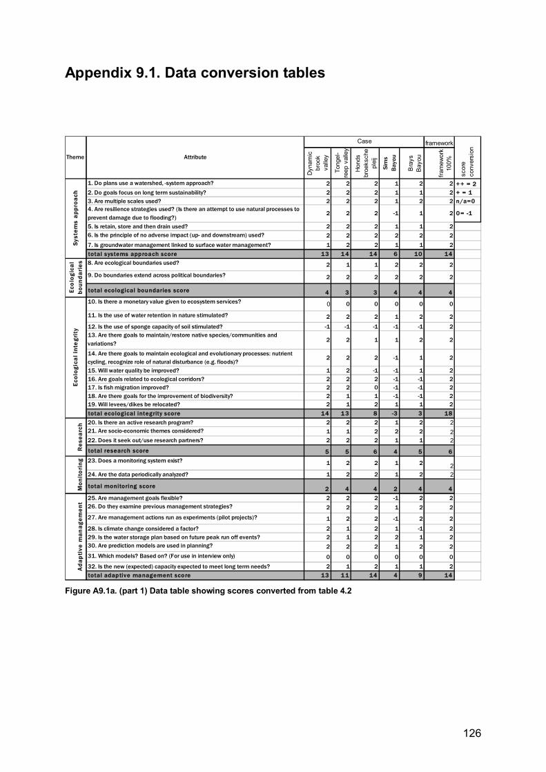
126
Appendix 9.1. Data conversion tables
framework
Dyn
amic
br
ook
valle
y
Tong
el-
reep
val
ley
Hon
ds
broe
ksch
e pl
eij
Sim
s Ba
you
Bra
ys
Bay
ou
fram
ewor
k 10
0%
1. Do plans use a watershed, -system approach? 2 2 2 1 2 2 + + = 22. Do goals focus on long term sustainability? 2 2 2 1 1 2 + = 13. Are multiple scales used? 2 2 2 1 2 2 n/a=04. Are resilience strategies used? (Is there an attempt to use natural processes to prevent damage due to flooding?)
2 2 2 -1 1 2 0 = -1
5. Is retain, store and then drain used? 2 2 2 1 1 26. Is the principle of no adverse impact (up- and downstream) used? 2 2 2 2 2 27. Is groundwater management linked to surface water management? 1 2 2 1 1 2total systems approach score 13 1 4 14 6 10 148. Are ecological boundaries used? 2 1 1 2 2 2
9. Do boundaries extend across political boundaries? 2 2 2 2 2 2
total ecological boundaries score 4 3 3 4 4 410. Is there a monetary value given to ecosystem services? 0 0 0 0 0 0
11. Is the use of water retention in nature stimulated? 2 2 2 1 2 2
12. Is the use of sponge capacity of soil stimulated? -1 -1 -1 -1 -1 213. Are there goals to maintain/restore native species/communities and variations? 2 2 1 1 2 2
14. Are there goals to maintain ecological and evolutionary processes: nutrient cycling, recognize role of natural disturbance (e.g. floods)?
2 2 2 -1 1 2
15. Will water quality be improved? 1 2 -1 -1 1 216. Are goals related to ecological corridors? 2 2 2 -1 -1 217. Is fish migration improved? 2 2 0 -1 -1 218. Are there goals for the improvement of biodiversity? 2 1 1 -1 -1 219. Will levees/dikes be relocated? 2 1 2 1 1 2total ecological integrity score 14 1 3 8 -3 3 1820. Is there an active research program? 2 2 2 1 2 221. Are socio-economic themes considered? 1 1 2 2 2 222. Does it seek out/use research partners? 2 2 2 1 1 2total research score 5 5 6 4 5 623. Does a monitoring system exist? 1 2 2 1 2 224. Are the data periodically analyzed? 1 2 2 1 2 2
total monitoring score 2 4 4 2 4 425. Are management goals flexible? 2 2 2 -1 2 226. Do they examine previous management strategies? 2 2 2 1 2 2
27. Are management actions run as experiments (pilot projects)? 1 2 2 -1 2 2
28. Is climate change considered a factor? 2 1 2 1 -1 229. Is the water storage plan based on future peak run off events? 2 1 2 2 1 230. Are prediction models are used in planning? 2 2 2 1 2 231. Which models? Based on? (For use in interview only) 0 0 0 0 0 032. Is the new (expected) capacity expected to meet long term needs? 2 1 2 1 1 2total adaptive management score 13 1 1 14 4 9 14
Ecol
ogic
al i
nte
grit
y
scor
e co
nver
sion
Ada
pti
ve m
anag
emen
t Ec
olo
gic
al
boun
dar
ies
Res
earc
hM
onit
ori
ng
Theme Attribute
Case
Syst
ems
appr
oach
Figure A9.1a. (part 1) Data table showing scores converted from table 4.2
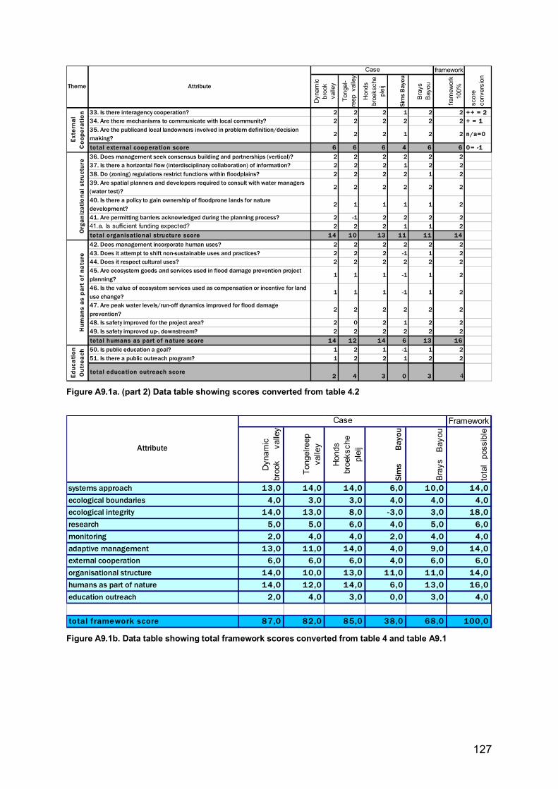
127
framework
Dyn
amic
br
ook
valle
y
Tong
el-
reep
valle
y
Hon
ds
broe
ksch
e pl
eij
Sim
s Ba
you
Bra
ys
Bay
ou
fram
ewor
k 10
0%
33. Is there interagency cooperation? 2 2 2 1 2 2 + + = 234. Are there mechanisms to communicate with local community? 2 2 2 2 2 2 + = 135. Are the publicand local landowners involved in problem definition/decision making?
2 2 2 1 2 2 n/a=0
total external cooperation score 6 6 6 4 6 6 0 = -136. Does management seek consensus building and partnerships (vertical)? 2 2 2 2 2 237. Is there a horizontal flow (interdisciplinary collaboration) of information? 2 2 2 1 2 238. Do (zoning) regulations restrict functions within floodplains? 2 2 2 2 1 239. Are spatial planners and developers required to consult with water managers (water test)?
2 2 2 2 2 2
40. Is there a policy to gain ownership of floodprone lands for nature development?
2 1 1 1 1 2
41. Are permitting barriers acknowledged during the planning process? 2 -1 2 2 2 241.a. Is sufficient funding expected? 2 2 2 1 1 2total organisational structure score 14 1 0 13 11 11 1442. Does management incorporate human uses? 2 2 2 2 2 243. Does it attempt to shift non-sustainable uses and practices? 2 2 2 -1 1 244. Does it respect cultural uses? 2 2 2 2 2 245. Are ecosystem goods and services used in flood damage prevention project planning?
1 1 1 -1 1 2
46. Is the value of ecosystem services used as compensation or incentive for land use change?
1 1 1 -1 1 2
47. Are peak water levels/run-off dynamics improved for flood damage prevention?
2 2 2 2 2 2
48. Is safety improved for the project area? 2 0 2 1 2 249. Is safety improved up-, downstream? 2 2 2 2 2 2total humans as part of nature score 14 1 2 14 6 13 1650. Is public education a goal? 1 2 1 -1 1 251. Is there a public outreach program? 1 2 2 1 2 2
total education outreach score 2 4 3 0 3 4
Exte
rnal
C
oope
rati
on
Org
aniz
atio
nal s
tru
ctur
eH
uman
s as
par
t of
na
ture
Ed
uca
tion
O
utre
ach
Theme Attribute
Case
scor
e co
nver
sion
Figure A9.1a. (part 2) Data table showing scores converted from table 4.2
Framework
Dyn
amic
br
ook
valle
y
Tong
elre
ep
valle
y
Hon
ds
broe
ksch
e pl
eij
Sim
sBa
you
Bra
ysB
ayou
tota
lpo
ssib
lesystems approach 13,0 14,0 14,0 6,0 10,0 14 ,0ecological boundaries 4,0 3,0 3,0 4,0 4,0 4,0ecological integrity 14,0 13,0 8,0 -3,0 3,0 18 ,0research 5,0 5,0 6,0 4,0 5,0 6,0monitoring 2,0 4,0 4,0 2,0 4,0 4,0adaptive management 13,0 11,0 14,0 4,0 9,0 14 ,0external cooperation 6,0 6,0 6,0 4,0 6,0 6,0organisational structure 14,0 10,0 13,0 11,0 11,0 14,0humans as part of nature 14,0 12,0 14,0 6,0 13,0 16 ,0education outreach 2,0 4,0 3,0 0,0 3,0 4,0
total framework score 87,0 82,0 85,0 38,0 68,0 100,0
Attribute
Case
Figure A9.1b. Data table showing total framework scores converted from table 4 and table A9.1
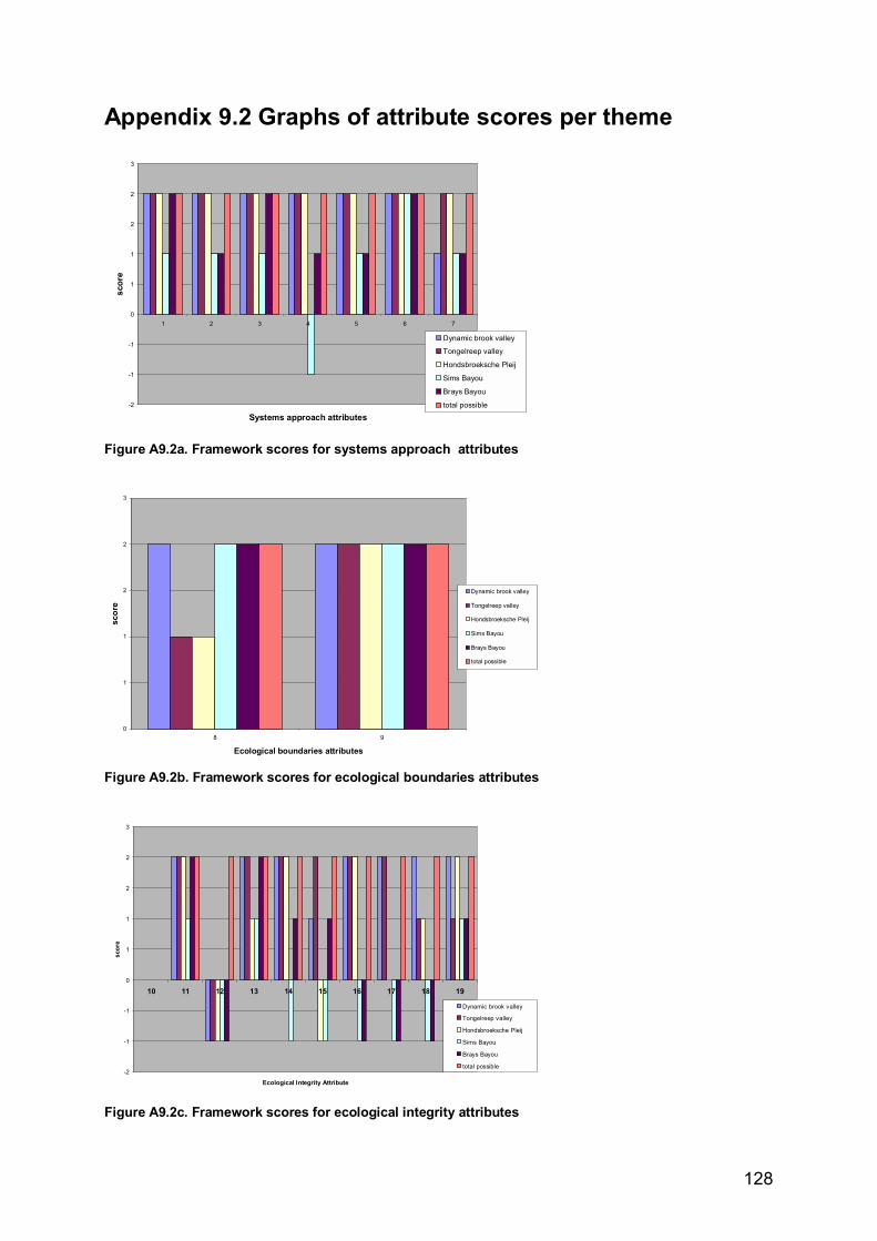
128
Appendix 9.2 Graphs of attribute scores per theme
-2
-1
-1
0
1
1
2
2
3
1 2 3 4 5 6 7
Systems approach attributes
scor
e
Dynamic brook valley
Tongelreep valley
Hondsbroeksche Pleij
Sims Bayou
Brays Bayou
total possible
Figure A9.2a. Framework scores for systems approach attributes
0
1
1
2
2
3
8 9
Ecological boundaries attributes
scor
e
Dynamic brook valley
Tongelreep valley
Hondsbroeksche Pleij
Sims Bayou
Brays Bayou
total possible
Figure A9.2b. Framework scores for ecological boundaries attributes
-2
-1
-1
0
1
1
2
2
3
10 11 12 13 14 15 16 17 18 19
Ecological Integrity Attribute
scor
e
Dynamic brook valley
Tongelreep valley
Hondsbroeksche Pleij
Sims Bayou
Brays Bayou
total possible
Figure A9.2c. Framework scores for ecological integrity attributes
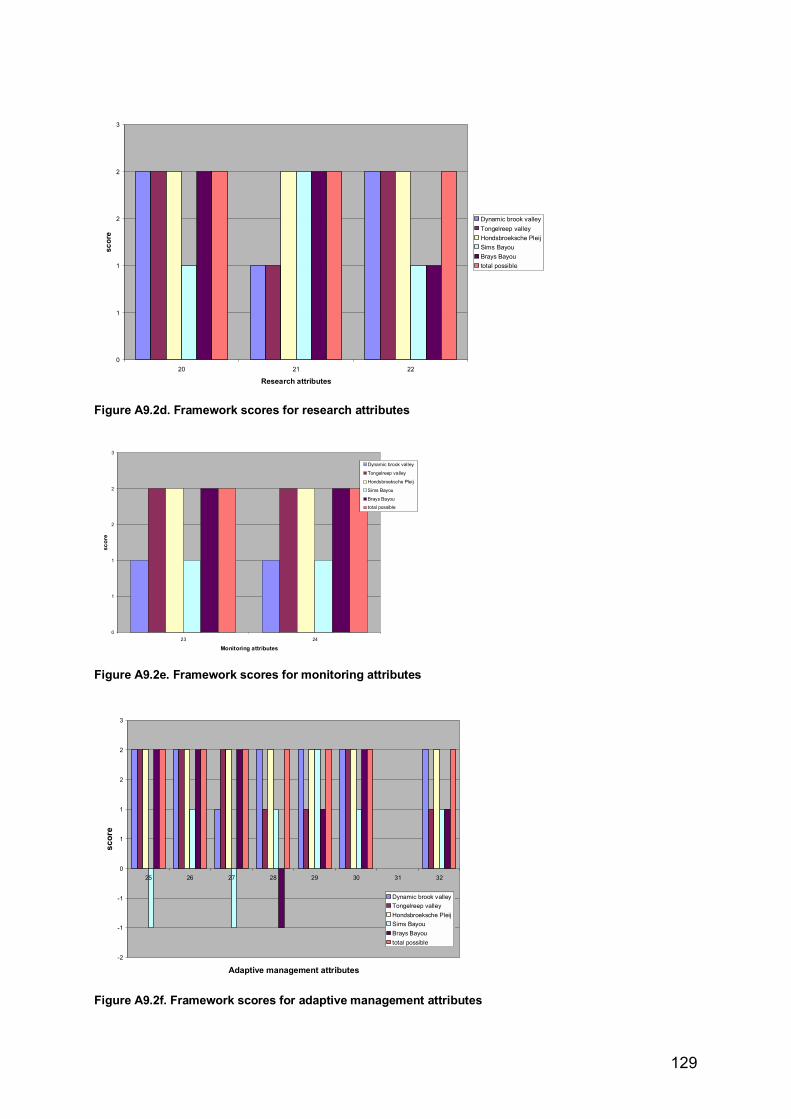
129
0
1
1
2
2
3
20 21 22
Research attributes
scor
e
Dynamic brook valleyTongelreep valleyHondsbroeksche PleijSims BayouBrays Bayoutotal possible
Figure A9.2d. Framework scores for research attributes
0
1
1
2
2
3
23 24
Monitoring attributes
scor
e
Dynamic brook valley
Tongelreep valley
Hondsbroeksche Pleij
Sims Bayou
Brays Bayou
total possible
Figure A9.2e. Framework scores for monitoring attributes
-2
-1
-1
0
1
1
2
2
3
25 26 27 28 29 30 31 32
Adaptive management attributes
scor
e
Dynamic brook valleyTongelreep valleyHondsbroeksche PleijSims BayouBrays Bayoutotal possible
Figure A9.2f. Framework scores for adaptive management attributes
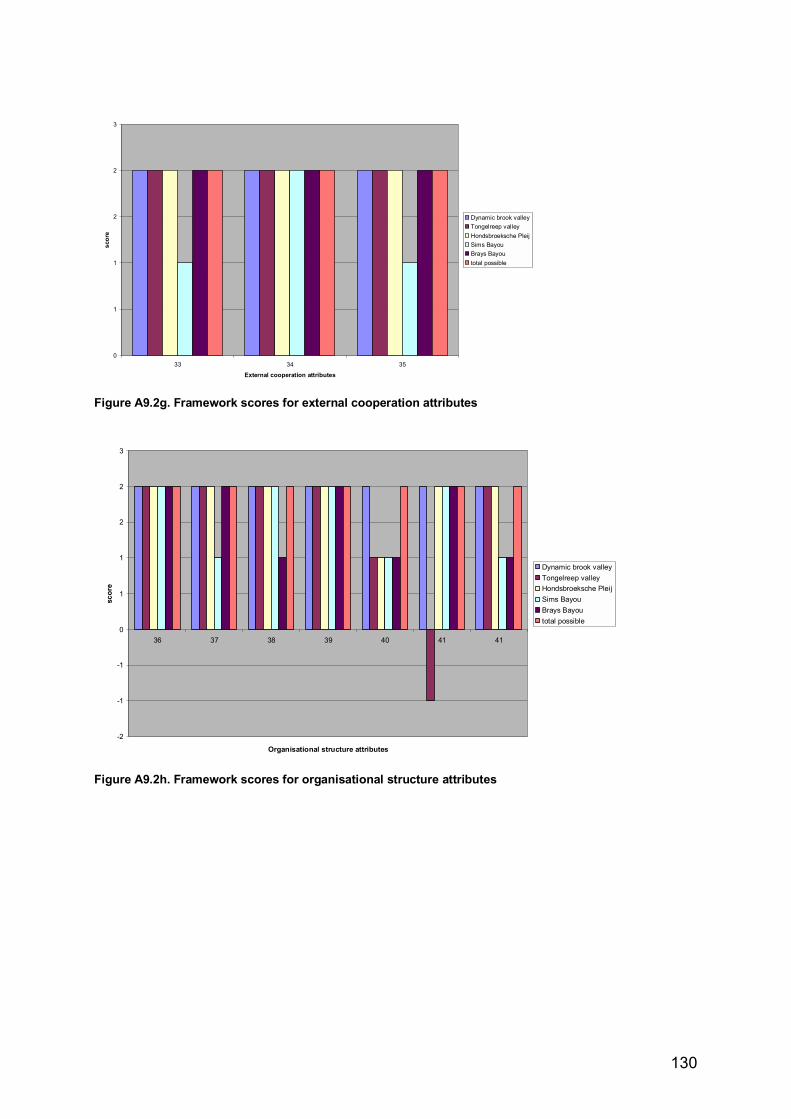
130
0
1
1
2
2
3
33 34 35
External cooperation attributes
scor
e
Dynamic brook valleyTongelreep valleyHondsbroeksche PleijSims BayouBrays Bayoutotal possible
Figure A9.2g. Framework scores for external cooperation attributes
-2
-1
-1
0
1
1
2
2
3
36 37 38 39 40 41 41
Organisational structure attributes
scor
e
Dynamic brook valleyTongelreep valleyHondsbroeksche PleijSims BayouBrays Bayoutotal possible
Figure A9.2h. Framework scores for organisational structure attributes
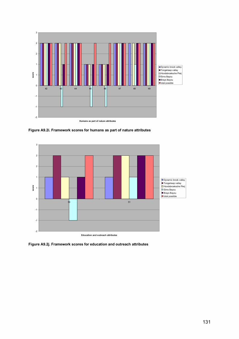
131
-2
-1
-1
0
1
1
2
2
3
42 43 44 45 46 47 48 49
Humans as part of nature attributes
scor
e
Dynamic brook valleyTongelreep valleyHondsbroeksche PleijSims BayouBrays Bayoutotal possible
Figure A9.2i. Framework scores for humans as part of nature attributes
-2
-1
-1
0
1
1
2
2
3
50 51
Education and outreach attributes
scor
e
Dynamic brook valleyTongelreep valleyHondsbroeksche PleijSims BayouBrays Bayoutotal possible
Figure A9.2j. Framework scores for education and outreach attributes

132
Last page☺