tulare county citizens for responsible...
TRANSCRIPT
Tulare County Citizens For Responsible Growth
1
May 27, 2010
Tulare County Resource Management Agency
David Bryant, Project Planner
Government Plaza
5961 South Mooney Boulevard
Visalia, CA 93277
RE: Tulare County Draft General Plan 2030 Update and Recirculated Draft Environmental Impact
Report
(SCH No.2006041162)
Dear Mr. Bryant:
Thank you for the opportunity to comment on the Recirculated Draft Environmental Impact Report
(RDEIR) for the revised Tulare County General Plan 2030 Update.
Tulare County Citizens for Responsible Growth is a diverse group of local residents concerned about the
direction of growth in our County. We are united by a desire for a General Plan Update (GPU) that will
ensure cleaner air, secure and reliable water supplies, a strong and more diverse economy, and the
protection of our agricultural and natural resource lands. We believe that focusing future growth in our
existing urbanized areas is the key to achieving these priorities.
We were pleased to see that many of the value statements and guiding principles set out in the revised
General Plan Update express similar desires. However, we are concerned that the revised General Plan
Update will not attain any of these goals because it will not meet the goal of creating a compact urban
form.
Our letter begins with a summary of our key concerns and recommendations on the GPU and RDEIR. We
then include additional detailed comments on the adequacy of the RDEIR. You will also be receiving
comment letters from some individual TCCRG members (which include extensive recommendations on
GPU text and policies/measures and RDEIR analysis and mitigation measures). Our comments include
both the General Plan Update and the RDEIR since they are each integral to the other.
Tulare County Citizens For Responsible Growth
2
I. Summary of Concerns
♦ Impacts related to sprawl not adequately evaluated or mitigated.
A variety of impacts will result from buildout of any General Plan which permits significant development
away from established urban centers, thus devouring agricultural and open space land unnecessarily,
contributing to unnecessarily increased VMTs, traffic commutes and traffic congestion, reduced air quality,
and a myriad of other impacts. Such is the case with the Tulare County General Plan Update. Its
foundation is a Planning Framework which purports to limit growth to existing urbanized areas, largely by
assuming that the major portion of new growth will take place within incorporated cities and their
designated urban boundaries, and relying on the City general plans as a guide for growth.
The General Plan Update Recirculated Draft Environmental Impact Report assumes that this land use
concept and its implementing policy framework will mitigate potential environmental impacts throughout
the County to a large degree. Yet this essential concept is weakened by the actual wording throughout the
General Plan to the point that effective mitigation simply cannot be assured.
A critical example is the fact that there is no real requirement in the Plan for the County to adhere to the
City general plans for compact growth within their Spheres of Influence and Urban Development
Boundaries (UDBs). In addition the County’s proposals to establish new “Growth Corridors” and “Planned
Communities” (formerly called New Towns) which could be allowed in the rural areas currently intended
for open space or agricultural protection because the Plan establishes no set boundaries for such new
development.
Likewise, the County has designated 11 small, unincorporated communities as “Hamlets” and provided
them with newly devised HDBs within which the RVLP is being repealed. The HDBs appear much larger
than necessary to support the modest growth needed to allow for the small scale retail services appropriate
to these communities and with no demonstration of any possibility of providing needed public facilities.
None of the 11 Hamlets has a Hamlet Plan to guide growth and development. The County is simply
declaring them all Mixed Use.
Where land use designations are not delineated specifically (such as in Hamlets, Growth Corridors,
Mountain Service Centers, and Foothill Mixed Use areas), the designation of Mixed Use is applied,
permitting any combination of uses and residential development from 1-30 units/ acre, resulting in “an
anything goes” plan for much of the unincorporated area.
Yet the RDEIR does not evaluate the impact of this weakening of the General Plan’s basic land use
framework. Rather, it generally concludes that loss of agriculture and open space and numerous other
impacts caused by sprawl will be significant and unavoidable without even exploring all available
mitigation. Clearly, strengthening the land use framework to better protect agriculture and open space and
minimize sprawl is an available and feasible mitigation measure that should be included in a revised
General Plan and RDEIR to substantially reduce impacts of the Plan.
In response to these concerns, Tulare County Citizens for Responsible Growth (TCCRG) recommends a
number of major concept revisions to the General Plan which will ensure a more compact urban form as
the County grows and which will serve to mitigate environmental impacts to a substantially greater degree
than that proposed in the RDEIR:
Tulare County Citizens For Responsible Growth
3
Major Concepts:
TCCRG Proposed General Plan Revisions
and
Mitigation Program
1. Require Consistency with incorporated City Plans and Efficiency of Growth in Unincorporated
Communities to Promote Compact Development Form.
To accomplish this, eliminate CACUABs and CACUDBs in favor of City control of their growth areas
coupled with equitable revenue sharing.
a. Eliminate the CACUABs and replace with agricultural designations.
This area is not needed to support the County’s growth projections for the GPU horizon, and should be
protected as urban/rural separators/buffers.
b. Ensure that urban development takes place in the following areas only:
Within incorporated cities and their designated growth areas as they annex,
Within UDBs of adjacent cities in other counties,
Within UDBs of unincorporated communities and HDBs of Hamlets after they are sized for modest, compact
healthy growth appropriate to each of these locations. (See 2b below.)
The intent is to eliminate County approved urban development in the City UDBs (other than under existing zoning
requiring no new parcelization or use permits) and to promote efficient non-sprawling development in
the unincorporated communities and hamlets. This would be more cost effective for the taxpayers and allow the
cities to deal with orderly resource-efficient growth in the areas to which they would be eventually providing
infrastructure and services.
2. Eliminate “Anything Goes” Features of the Plan. No Growth Corridors or New Towns.
a. Eliminate the proposed Growth Corridors and Planned Communities (New Towns) in the unincorporated area.
b. Create Hamlet Development Boundaries (HDBs), unincorporated community boundaries (UDBs), and land use
designations within them only after specific land use plans are inclusively created for each which clearly locate land
uses of an appropriate scale of neighborhood, commercial, and non-residential uses, developed only concurrent with the
provision of needed infrastructure and developer mitigation fees, and which are consistent with Development
Efficiency Targets.
3. Protect Agriculture and Open Space –
Use Development Efficiency Targets to Protect Agriculture and Open Space, Reduce Sprawl, and Require
Agricultural and Open Space Conservation Easements
a. Require a system of Development Efficiency Targets, such as the ones proposed by the American Farmland Trust in
their 2007 Comment Letter (attached), before a UDB or HDB is revised and before any individual discretionary land
use development project, policy, or program is approved.
b. Revise the agricultural and open space conservation easement policies to require that when developments are
approved that will result in the loss of prime, important, or unique agricultural or open space, a fee will be assessed
sufficient to purchase agricultural and open space protection easements of equal value elsewhere in the county, at a
minimum ratio of 1:1.
4. Adopt the Healthy Growth Alternative – Revised Alternative 5.
We continue to support a Healthy Growth Alternative which incorporates the measures above and ensures an 80% (or
greater)-20% city/county growth scenario. This alternative is a revision of Alternative 5, the Confined Growth
Alternative, which is considered the Environmentally Superior Alternative by the RDEIR. With the revisions we have
recommended, this alternative would remain environmentally superior and would fully meet all of the General Plan
Project Objectives.
Tulare County Citizens For Responsible Growth
4
♦ Efficient Development Patterns Needed.
The most assured way to promote compact urban form and protect agriculture and other important open
spaces is to ensure that most of the growth in the county will occur within the existing and future City
limits, under control of the cities. In order to achieve this goal, the County land use designations and
zoning in the UABs and UDBs surrounding the cities must be exclusively agricultural and open space so
that development will be encouraged within the cities and their development expansion areas. The
experience throughout California is that this will simply not occur if urban development is permitted under
two different jurisdictions, with developers competing for suburban densities over urban densities, lower
fees, and less urban infrastructure requirements. It certainly will not occur under the weak CACUAB and
CACUDB policies in the Planning Framework.
Additional growth is appropriate and needed in the unincorporated communities and hamlets. Such growth
will not result in sprawl, however, if long-term planning boundaries firmly limit the circumstances under
which they can be expanded. The Plan does not accomplish this, since it establishes significantly
oversized UDBs and HDBs around the communities and hamlets and permits an interim allowance of
“anything goes” Mixed Use” land use. In addition, the GPU policies create far too many opportunities for
the UDB to be changed anytime there is a subdivision proposal, or potential “financial benefits” to the
county, or even “any other relevant factor considered on a case by case basis.” This is no more than the
market driven approach roundly criticized in the 2008 Draft general Plan Update, without a name. The
result is that the Urban Development Boundary and Hamlet Development Boundary are no boundaries at
all. We recommend that the proposed development boundaries around the communities and hamlets not be
delineated in the General Plan Update. A General Plan amendment should be required for any
establishment of these development boundaries in addition to an amendment to the community or hamlet
plan (if one has been adopted). The focus of these plans and boundaries should be on revitalization of
existing urbanized areas before allowing greenfield development, especially in areas that lack adequate
infrastructure and reliable water supplies.
Consistent with our previous recommendations, we also support the American Farmlands Trust proposed
Development Efficiency Targets. Such a policy has two benefits: (1) it will minimize the conversion of
lands important for agriculture and natural resources by ensuring that every acre is used efficiently; and (2)
efficient development fosters a built environment that is more conducive to economically sound
development patterns, making communities more attractive to both investors and residents by emphasizing
mixed-use, and promoting pedestrian, bicycle, and public transit services, which in turn promote better
health, lower pollution and GHG emissions, a feeling of community, and overall better quality of life.
♦ Planned Community Areas, New Towns and Growth Corridors Negate the Concept
of
Compact Urban Form and Farmland Protection.
The Planned Community (formerly called New Town) and Growth Corridor concepts furthered in the
General Plan fundamentally undermine its Guiding Principles within the Planning Framework which
emphasize avoiding rural residential sprawl and protection of important agricultural resources, and it
directly contradicts the priorities of the citizens of Tulare County. In effect, this provision encourages the
building of entirely new towns by failing to establish any specific, measurable standards for when such a
Tulare County Citizens For Responsible Growth
5
massive undertaking might be “justified” by unspecified and unlimited “circumstances” that “should be
judged on their individual merits.” (PF-5.1) This vague language leaves the door to “leapfrog”
development wide open. A New Towns provision is no longer needed or justified: planned communities
can easily be accommodated within existing development boundaries, Tulare County citizens want growth
focused in existing communities, and they don’t want new towns.
As reported by the County’s own consultants, the County’s existing cities, communities and hamlets
already offer more than enough land within their existing development boundaries to accommodate 50
years worth of growth at current densities; more than that at higher densities. Moreover, existing urban
areas can more efficiently expand their infrastructure to support such growth at a much lower cost than
would be required to establish entirely new roads, water and power systems, public safety facilities,
schools, etc.
The County’s existing urban areas should be permitted to grow and provide whatever “benefits” any new
town could provide. Instead, the New Town and Growth Corridor policies force Tulare County’s cities,
hamlets and communities to compete with undeveloped land for investment dollars. While infill
development may be more of a challenge to developers, it can also be ultimately more rewarding, as
property values rise as a result of their development. Infill development also benefits the entire community
– not just a particular development – as older downtowns revitalize, attracting new businesses and good-
paying jobs, and bringing much-needed revenue to improve aging infrastructure.
By inviting New Town development in the guise of Planned Community Areas, Tulare County is putting
its existing communities at a competitive disadvantage and jeopardizing their chances of getting the
investment they need. This growth-inducing policy will also invite sprawl; worsen air quality; increase
traffic problems; accelerate loss of agricultural lands, wildlife habitat, open space, and scenic views; result
in higher costs and greater inefficiencies because of failure to utilize existing services, facilities, and
infrastructure; and increase pollution and GHG emissions unnecessarily – to the detriment of the quality of
life of all Tulare County residents.
The RDEIR has not examined the impacts of New Towns. Of particular concern is their potential impact
on existing communities. The assumption that the criteria listed in the General Plan for New Town review
assures they will not cause substantial impact is speculative at best and inappropriately defers this
important subject to further study. As explained above, it is likely that creation of New Towns in Tulare
County would result in significant adverse impacts on existing communities, many of which already suffer
from lack of adequate infrastructure and public services. Moreover, the County must specifically define the
conditions under which New Towns may be considered justified. The rules should be defined during the
General Plan Update process, not tailor-made for each individual project at the time the project is proposed
for approval.
We recommend that this policy be removed altogether and that New Towns be prohibited instead as there
is NO NEED for New Towns, and County citizens have said they don’t want to see the development of,
entirely new towns.
We have a similar concern with the proposed Regional Growth Corridors. Many miles of the County’s
highways in the unincorporated area could be developed under these policies, and without a plan! Policy
C-1.6 permits development in these corridors (which are unspecified) before a plan is developed and with
minimal criteria. The RDEIR has not demonstrated how these minimal criteria would mitigate potential
Tulare County Citizens For Responsible Growth
6
impacts. If the locational criteria are met, a substantial amount of commercial and industrial development
could be allowed, in competition with existing urbanized areas, similar to the impacts of New Towns as
described above. Permitting development of these Growth Corridors simply is not consistent with
numerous policies in the General Plan intended to attempt to encourage (though, regrettably not to require)
a compact urban form Certainly, the visual impacts could be substantial; this impact has not been
adequately discussed in the RDEIR. We recommend that the GPU be revised to prohibit the development
of these Growth Corridors and to focus such development in the urbanized areas that could support and
benefit from it.
II. Additional Detailed Comments on RDEIR Adequacy
Our detailed comments on the adequacy of the RDEIR follow.
♦ Project Description flawed.
Buildout of the Plan not quantified.
Land Use Diagram not complete.
The Project Description is fatally flawed in that the General Plan and the RDEIR never illustrate or
quantify what the project actually adds up to. State law requires that: “A land use element designates the
proposed general distribution and general location and extent of the uses of the land for housing, business,
industry, open space, including agriculture,… and that it “include a statement of the standards of
population density and building intensity recommended for the various districts.” and other territory
covered by the plan.” (Government Section 65302 (a). These basic requirements are not met in the
General Plan Update making it also impossible to set forth an adequate project description in the RDEIR.
“An accurate, stable, and finite project description is the sine qua non of an informative and legally
sufficient EIR.” (San Joaquin Raptor/Wildlife Rescue Center vs. County of Stanislaus, 1994.)
There is no buildout chart in the General Plan Update or in the RDEIR. General Plan Table 4.1 outlines
densities permitted in the various land use designations and where they are allowed. However, there is no
tabulation of how many acres of each designation have been allocated and how many acres are vacant or
underutilized in each category. This information must be provided, and then be used to multiply permitted
densities by acreage and determine both a 2030 buildout and an ultimate holding capacity. Without this
information, we cannot determine the most basic question: Has too much land been slated for
urbanization, resulting in impacts greater than necessary?
In addition, the land use designations are not shown on the Tulare County Planning Areas map (GPU/GPR
Figure 4-1, p 4-5). The various community plans and area plans are incorporated by reference. Yet, one-
third of the unincorporated communities and none of the Hamlets and MSCs have adopted plans. As a
result, there are many areas that simply have not received land use designations more detailed than a
Planning Framework boundary. (The UABs are an example.) A policy framework cannot meet the
requirements of State law for what should be the simplest part of the General Plan for a citizen to
understand: its illustration - the Land Use Map. The Land Use Map is the portion of the General Plan that
in the future will receive the most use. After the policies become a bit dusty, the Map will be used on a
daily basis. A citizen cannot look at the General Plan Update Land Use Map in its current condition and
Tulare County Citizens For Responsible Growth
7
determine what land uses are permitted in the UABs, the Growth Corridors, the Hamlet UDBs, and many
other areas of the county.
Without a complete Land Use Diagram and buildout calculations, numerous critical questions cannot be
answered:
● What is the potential 20 year buildout population if the entirety of the UDBs, HDBs, and MSCs were to
build out?
● The RDEIR relies on a population growth projection as the core of the Project Description (RDEIR page
2-24) with no spatial component other than a determination that State growth projections and traffic
modeling led to a determination that the unincorporated area could accommodate 25% of the growth.
(RDEIR page 2.24, para 3). How much more could the unincorporated area within the UBDs and HDBs
actually accommodate? Could the Plan prediction of a 75%-25% city-county growth ratio expectation be
exceeded by growth in the unincorporated areas of the county, as allowed by these UDBs and HDBs?
● The myriad of specific plans and area plans which make up the Land Use Map have not all been
quantified as to 2030 or full buildout potential. What is the true total buildout potential in the
unincorporated areas?
The RDEIR Project Description goes on to very generally conclude that future growth assumptions are
consistent with “several’ of the Update objectives (RDEIR page 2-24). In fact, the RDEIR Project
Description fails to mention that numerous Planning Framework policies are actually worded counter to
the argument that 75% of the new growth is expected to occur in cities. As an example, PF-4.24 notes that
the County “may” (and, thus, we assume may not) refer development proposals to the cities for annexation.
The RDEIR simply ignores the difficult but essential task of determining specifically where growth
actually could occur based on the General Plan Land Use Map proposed.
In addition to lack of figures for the year 2030 buildout, the RDEIR does not answer the question: What is
the full population capacity of the Land Use Diagram, including the vast 50 year UABs and the various
Mixed Use areas which could permit up to 30 dwelling units per acre? The maximum density permitted in
each land use category by the General Plan must be evaluated to understand its full impact potential. As
discussed previously, State General Plan law requires that all general plans specify the density and
intensity permitted on all lands within the plan. To determine full buildout potential, the Plan and the
RDEIR would need to multiply acreage of each land use type by the density and intensity permitted to
complete RDEIR Table 2-10 (GPU Table 4.1). Clearly, it was assumed by the State via General Plan law
that full density and intensity could occur (Government Code Section 65302 (a)). Certainly, the experience
of land use in California is “if you zone it, they will come.”
Thus, the question remains, what are the impacts of the plan? Without an accurate Land Use Diagram, and
its quantification, most of the Plan’s impacts cannot be accurately determined, and many can hardly be
guessed at.
An understanding of 2030 and ultimate capacity buildout potential could lead to advisable, quantifiable
mitigation such as restrictions on the timing of growth, reduction of growth areas, adjustment of densities,
etc. The RDEIR and the GPU are not legally adequate without an understanding of the Project Description

Tulare County Citizens For Responsible Growth
8
which must include full buildout of the General Plan Update both in population and spatially in 2030 and
at full capacity.
Confusing Land Use Diagram – What Is the Plan?
The Project Description as well as the GPU are also inadequate because of the confusing land use
designation system developed (RDEIR page 2-21). Existing community plans, area and sub-area plans,
and county adopted city general plans are listed and incorporated by reference. However, a citizen would
need to find the land use maps in these plans to piece together an understanding of the whole. The GPU
goes to the extent of including numerous maps delineating the boundaries of these plans, but not the land
use designations within them. In addition, the remainder of the County includes vast areas (in UABs,
HDBs, Growth Corridors, and Community UDBs) that do not have specifically assigned designations; they
are designated Mixed Use over a large area or they are retaining existing General Plan designations which
may or may not be consistent with the policies of the General Plan Update.
♦ Numerous critical policies and measures are so vaguely
worded that mitigation simply cannot be assured.
The draft GPU provides future elected officials with too little real guidance, and the people of Tulare
County with too little assurance, that their vision for the County’s future will be protected. We need a
General Plan with strong, clear, enforceable policies and concrete, trackable, timely implementation
measures.
The GPU states that a policy is “a statement that guides a specific course of action for decision-makers to
achieve a desired goal. The County has strived to develop clear and unambiguous policies” (GPU Part I,
page 1-8). The Goals and Policies Report (GPR) goes on to state that the GPR is the “essence” of the
General Plan and that it “identifies a full set of implementation measures that will ensure the goals and
policies in the General Plan will be carried out.” Finally, the GPR states that an implementation measure is
“a specific measure, program, procedure, or technique that carries out plan policies” and that
“Implementation measures describe actions that are measurable so their completion can be easily
monitored in annual reports” (GPU, Part I, page 1-11).
Unfortunately, the GPU fails to meet its own standards in many respects. Many of the policies are far from
specific, clear, and unambiguous, and many have no identified corresponding implementation measures.
Many of the implementation measures that are provided are so vague as to be neither measurable nor
enforceable; many state that they are “new,” yet indicate for their timeline that they are “ongoing,” so that
one cannot determine whether they are supposedly already being implemented (in which case the date of
actual implementation should be shown) or when one could expect them to be in force; others are
scheduled to be commenced so far in the future that it is doubtful that much in the way of meaningful
outcomes can be made to result from them within the life of the General Plan Update. Many
implementation measures are cited in the RDEIR to serve as mitigation. However, the definition of
implementation measures in the General Plan Update (see GPU/GPR page 1-11.) weakens the ability of
these measures to effectively mitigate impacts. For example, timelines are considered “general guidelines”
and “completion of various tasks… are subject to available staff, financial resources, and other
considerations” (see GPU/GPR page 1-11.).

Tulare County Citizens For Responsible Growth
9
As an example, the General Plan Update’s foundation is a series of policies and measures which purport to
limit sprawl and haphazard growth which is the source of many adverse impacts of growth including loss
of agriculture and open space, reduction in quality of public services and facilities, reduced air quality, and
increased traffic, VMTs, and GHGs, etc. And yet, these very policies and measures are not required to be
carried out in the General Plan Update which uses weakly directive terms such as “may” or “should” or
“encourage.” As a result, the impacts resulting from the buildout pattern permitted by the General Plan
cannot be expected to be mitigated below the significant level. The foundation on which the Plan rests is
simply not firm.
An EIR must provide substantial evidence demonstrating that the recommended mitigation measures are
capable of: “(a) avoiding the impact altogether by not taking a certain action or parts of an action; (b)
minimizing impacts by limiting the degree or magnitude of the action and its implementation; (c) rectifying
the impact by repairing, rehabilitating, or restoring the impacted environment; or (d) reducing or
eliminating the impact over time by preservation and maintenance operations during the life of the action.
(CEQA Guidelines §15370.) The RDEIR must use these tests to analyze whether or not the language
“may” or “should” and other language which may weaken the actual implementation of policies and
measures will actually result in effective mitigation. We argue that it will not, because the decision makers
will not be required to carry out the underlying intent and the decision will be left to the whims of politics.
As an example of ineffective mitigation wording, the General Plan Update Planning Framework policies
are cited throughout the RDEIR chapters as mitigating in nature. A system of concentric growth
boundaries around the cities and various unincorporated areas and a series of associated policies purporting
to focus most growth in city spheres of influence and urban development boundaries form the Planning
Framework (General Plan Update Part I, Chapter 2). The RDEIR claims that these policies will serve to
limit sprawl, preserve agriculture to some degree, reduce traffic and air quality impacts, and more.
However, as discussed above, the vague wording used in most of these policies will not ensure that these
concepts are carried out; in other cases the concepts themselves are flawed (such as that the UABs will
serve to focus growth) and will not reduce sprawl.
For instance, the General Plan Update sets forth a basic program in its Planning Framework that it claims
would focus growth largely in the existing cities. To do this, the General Plan Update claims that it will
rely on the City General Plans for these areas. However, the policy enacting this program does not require
that it be carried out:
PF-4.8. General Plan Designations Within City UDBs. On land that is within a CACUDB, but outside a city’s incorporated limits, the County may
[emphasis added] maintain General Plan land use designations that are compatible with the city’s
adopted General Plan.
In addition, the policy which discusses how land use proposals submitted to the County in the areas just
outside the cities (CACUDBs) will be handled does not require that land use proposals be referred to the
cities for potential annexation, leaving no teeth in the policy:
PF-4.24 Annexations to a City within the CACUDB
In addition to the County’s current policies on development within a CACUDB, the County may
[emphasis added] work with a city to provide that urban development projects within a city’s

Tulare County Citizens For Responsible Growth
10
Sphere of Influence (SOI) as set by the Tulare County Local Agency Formation Commission will be
referred to the affected city for consideration of annexation…..
The second concentric growth boundary circle proposed around the cities is an Urban Area Boundary
(UAB), intended to provide for 50-year growth. The GPU claims that this area will be limited in growth,
and planning will be coordinated with the cities. However PF-4.1, establishing the UABs around cities,
states only that: “the cities’ concerns may [emphasis added] be given consideration as part of the land use
review process…” In addition, this policy states that this area “will generally have an agricultural land
use designation or rural residential land use designation…” Yet the rural residential designation can
include rural ranchette 10 acre parcels (General Plan Table 4.3 - Countywide Land Use Designation
Matrix) which is an inefficient parcel density counter to efforts to preserve agriculture and reduce sprawl.
In addition, the Rural Valley Lands Plan is only advisory in the UABs. The policies attempt to allow some
additional control by the County in these areas, but the wording used only notes that the County “may”
work with individual cities to ensure that the RVLP policies apply in these areas (PF- 4.19, PF-4.21). In
fact, the RDEIR admits in the Agricultural Resources section that development per the GPU in the UABs
and HDBs will result in loss of up to 59,645 acres of important agricultural land (RDEIR Table 3.10-9), a
significant “unavoidable” impact.
The ability of the General Plan Update to limit sprawl is further weakened by the fact that unincorporated
hamlets may be expanded substantially (PF-3), that New Towns (Planned Community Areas) may be
formed (PF-5.1), and that Regional Growth Corridors (C-1.6) will be created. In addition, until plans are
prepared for the Hamlets, Growth Corridors, and Community UDBs, the underlying land use designation is
Mixed Use, which as defined in the General Plan Update permits an “anything goes” type of planning. Up
to 30 units per acre of residential use are allowed and any type of commercial use is allowed, with only
vague direction given: “The consideration of development proposals in Mixed Use areas should
[emphasis added] focus on compatibility between land uses, and the development potential of a given area
compared to the existing and proposed mix of land uses and their development impacts.” (General Plan
Update Part I, page 4-20). The creation of these growth areas, located generally in the middle of
agricultural areas, is inconsistent with the Planning Framework, and the wording in the policies guiding
their review is so permissive as to be ineffective, not serving to mitigate any potential impact.
Further, the General Plan Update does not require that the County, in permitting development within the
CACUDBs and CACUABs, to conform to City infrastructure standards, public service level of service
targets, or fee structures. (See policies PF-4.2 and PF 4.27.) Without equal standards and fees, developers
will pit the County against the City and generally choose to develop where they are the lowest. And, under
GPU policies, a project can be developed under County jurisdiction and not be required to annex to the city
at a future date. (Policy PF 4.24d)
The actual impact of these weakly worded Policy Framework policies and permissively worded growth
plans in the form of New Towns (PCAs), Growth Corridors, and Hamlet and Community development
boundaries would be the opposite of what is claimed in the RDEIR, resulting in heightened impact levels
and inadequate mitigation. Under these Planning Framework policies, a proposed project in an
unincorporated area can be referred to a city, denied annexation by the city at that time for appropriate
reasons (such as inconsistency with their general plan or untimely development), yet can then be approved
by the County with a potentially inconsistent land use density, with infrastructure that does not meet City
standards, and under fees that will not provide for urban public facility levels of service. In addition, the
Tulare County Citizens For Responsible Growth
11
project may never be required to annex to the City in the future (which would be the only remaining way to
eventually create a consistent buildout pattern in the area in question).
There is a pattern of wording of these policies that makes it clear that the County may not truly be
interested in a compact, resource-efficient urban form; there are loopholes in almost every relevant policy
allowing the County to ignore City zoning and standards. And, there are loopholes which would permit
extensive growth outside the cities. Rather than extensively revise the policy wording, it would be more
effective as mitigation to eliminate the UABs, require the County to designate the city UDBs agricultural
with urban plans to be implemented by the cities in this area, prohibit the New Towns PCAs) and Growth
Corridors, and revise the hamlet and community boundaries as we have recommended earlier in this letter.
Weakly worded mitigating policies and implementation measures are found throughout the RDEIR and the
GPU. They must be rewritten to assure effective mitigation and a legally adequate EIR.
♦ Not all available and feasible mitigation is explored in the RDEIR.
An EIR must explore all available feasible mitigation measures even if they are not selected (CEQA
Guidelines § 15091(a)(c)) and Stevens v. City of Glendale (1981).) In some cases, the RDEIR "drops the
ball" and concludes that an impact is unavoidable when, in fact, mitigation measures may be available.
Feasible mitigation measures must be identified even if they do not fully mitigate impacts in an attempt to
reduce impacts to the greatest degree feasible, even if an alternative approach would impede to some degree
the attainment of the project objectives, or would be more costly. (CEQA Guidelines § 15126.6(b.).
Throughout these comments on the RDEIR, we point out mitigation measures which have not been
explored and which will provide greater mitigation than that provided in the RDEIR. The RDEIR must be
revised to explore all such measures and adopt them when determined to be feasible.
♦ Existing Setting description inadequate.
There is no totaling of potential buildout under the existing General Plan or zoning in either the RDEIR or
the General Plan Update. The General Plan Update Background Report does include a number of charts
with some totaling of zoning or general plan designations by acreage and some population projections:
Chapter 3 includes charts that total existing acreage zoning by category for the Rural Valley Lands Plan,
Kings River Plan, the Foothill Growth Management Plan and the Mountain Planning Regions sub-areas.
However, buildout calculations are not presented and cannot be determined by the reader since acreage is
not identified as developed or undeveloped. The community plans have the most existing land use
designation data presented (General Plan Update Background Report Table 3-6). However, the population
projections are only for the plan period, not the full buildout potential, which cannot be determined by the
reader with the data presented. Some of this information is available in individual adopted plans, but in
total there is no way to determine what the existing County General Plan permits. Since the General Plan
buildout calculations of the incorporated areas of the cities are not presented, the true existing buildout
potential of the entire county cannot be understood.
Tulare County Citizens For Responsible Growth
12
From a CEQA standpoint, without a knowledge of the buildout potential of the existing General Plan, it is
impossible not only to understand the existing setting, but also to compare it to the proposed General Plan
Update in the alternatives section of the RDEIR. And, clearly, it was not available during the creation of
the proposed Land Use Diagram to inform decision making. It appears that the existing City Plans with
modest expansion room into the UDBs alone could provide for all the growth projected for the County to
2030.
♦ Land Use and Aesthetic Impacts
Division of the physical arrangement of an existing community discussion and mitigation inadequate
(Impact 3.11). This impact discussion again relies on policies which cannot be assured of mitigation
because of vague wording such as: “The County may [emphasis added] ensure proposed development
within CACUABs is compatible with future…circulation networks as shown in city plans” (PF Policy 4.12)
and the County “may” require a development project to meet the County adopted city development
standards of the city in question (PF Policy 4.10). (Other examples include PF Policies 4.6, 4.8, 4.9, 4.13.)
The General Plan Update maintains that the outer ring of development around the cities, the CACUABs
will generally have an agricultural or rural residential land use designation (Policy PF-4). Yet Rural
Residential land uses are permitted; these ranchette type densities run counter to the goal of reducing rural
residential sprawl cited in the Guiding Principles. This remains a potentially significant impact which
would best be mitigated by elimination of the CACUABs and assignment of agricultural zoning only in
these areas.
However, of most concern related to dividing the physical arrangement of an existing community (which
we assume is the current built form of the county) is the structure providing for “Planned Communities”
(formerly called New Towns) and Growth Corridors within the General Plan Update, which has been
discussed previously in this letter. Though these land use designations have not been specifically located
yet, they clearly have the potential to alter the urban, suburban, and/or rural form of Tulare County.
Implementation measures outline planning issues which must be addressed in these plans; however clearly,
the magnitude of these entirely new growth areas has the potential for significant impacts. In the case of
the Regional Growth Corridors, which could extend along much of the major highways in the County
(RDEIR Figure 2-1), highway oriented commercial, industrial, and mixed use development may be
approved by the County immediately, pending adoption of Regional Growth Corridor plans (Policy C-1.6).
The Planned Communities must be at least 200 acres in size. The RDEIR does not discuss the potential for
these new land use concepts to alter and divide the built form of the county. We maintain that impacts are
unavoidable because of the magnitude of what is proposed and diversion from the current built form of the
unincorporated County, regardless of the future planning that may be involved.
The RDEIR is inadequate without a discussion of these issues and incorporation of the available and
feasible additional mitigation recommended.
Conflict with other adopted land use plans discussion and mitigation inadequate (Impact 3.1.2).
The RDEIR concludes that this impact is less than significant, in part because “policies in the Planning
Framework are specifically designed to direct urban development within UDBs of existing cities,
communities, and other County planning areas to ensure that all development is well planned and
adequately served by infrastructure” (RDEIR p. 3.1-23). However, again, a number of the policies cited
as mitigation in this section include vague language which will not ensure implementation. For example,
Tulare County Citizens For Responsible Growth
13
PF-4.8 notes only that the County “may” maintain General Plan designations that are compatible with the
City’s adopted general plan. In policy PF-4.13, it is recognized that if the City is not ready to annex a
property in a UDB, the County can permit development if it determines that it is not incompatible
development. Similarly, in policy PF-4.10, the County states only that it “may” require a development
project to substantiate sufficient water supply and meet the County adopted city development standards of
the city in question. And per policy PF-4.12, the County “may” (or may not) ensure that proposed
development within CACUABs is compatible with future sewer and water systems, and circulation
networks as shown in city plans.
Numerous other Planning Framework policies cited as mitigation in the RDEIR will not, because of their
non-directive wording, ensure implementation of City plans. (Other examples include PF 2.2, 2.3, 4.1,
4.2,4.5, 4.6, 4.9.)
The conclusion of less than significant relative to conflict with other adopted land use plans cannot be
reached without the revision of these and related policies to include directive language such as “shall” or
“must.”
♦ Impacts to Agricultural Resources
Not all available agricultural impact mitigation is explored.
Land Use Map revision needed.
As discussed previously, the RDEIR does not explore all available mitigation as required by CEQA. This
is particularly evident in the Agricultural Resources impact section. Rather than explore possibilities for
effective mitigation, the RDEIR,by concluding that 59,645 acres of farmland may be lost under General
Plan buildout “drops the ball” by neglecting to explore effective mitigation and concluding that impacts
are unavoidable. Only one mitigation measure is added, and it does not even require action: “The County
shall consider (emphasis added) the implementation of an Agricultural Conservation Easement
Program…” (Agricultural Element Implementation Measure #15).
The most obvious way to reduce loss of agriculture to urban uses is to simply revise the Land Use Map,
which the RDEIR fails to discuss. Elimination of all or part of the city CACUABs alone could retain up
to 49,600 acres of farmland according to the RDEIR’s own figures (RDEIR Table 3.10-9). Even assuming
that existing sprawling Rural Residential zoning is retained in these CACUABs, a substantial amount of
farmland would still be preserved. UDBs around the unincorporated communities, Hamlet HDBs , and
Growth Corridors could also be decreased in size. Combined with the Development Efficiency Targets
discussed below, it is expected that the target population of the County could still readily be
accommodated in this decreased urbanization area and impacts related to loss of agriculture and open space
could be reduced below the significant level.
Efficiency of development needed to reduce sprawl.
Other mitigation options have been suggested which were not explored in the RDEIR. The American
Farmland Trust (AFT) in their comments has recommended a Development Efficiency Target review
system. Again, the RDEIR concluded that approximately 59,645 acres of agricultural land could be lost by
Tulare County Citizens For Responsible Growth
14
2030 under buildout of the General Plan Update. The American Farmland Trust estimated in 2007 that if
the efficiency of development were increased to the Valley-wide average of 8 people per acre, only 23,675
acres would be needed to accommodate growth through 2025; and if it were increased to 15 people per
acre, roughly comparable to the prevailing average in the Bay Area and urban Southern California, only
12,625 acres would be needed – less than 20 percent of the land currently planned for development (AFT,
2007 comments attached). Clearly, the AFT proposal would increase the efficiency of development and
reduce overall per capita land consumption. This system is set forth below and should be evaluated and
included as mitigation in the RDEIR in addition to Land Use Map changes:
Add PF 1.1a: Development Efficiency Targets
Efficient Development to Minimize Agricultural and Other Resource Land Conversion
The County shall promote efficient development that minimizes the conversion of agricultural land
and other resources by adopting and applying Development Efficiency Targets in making future
land use decisions affecting agricultural and open resource land. The County shall establish
Targets for average residential density and commercial floor-to-area ratios (to be applied to public
projects as well as private development), based on the amount of land to be dedicated to these uses,
the projected population and the goal of limiting future urbanization of agricultural and other open
land within the County (including those portions within cities) to not more than 16,000 acres
through the year 2030. (This implies an average development efficiency of about 12 people per acre
over the period, almost three times the current trend in Tulare County.)
The County shall use these Targets (and encourage cities to use them) to evaluate existing spheres
of influence and urban development boundaries, existing zoning districts, rezoning petitions,
community and specific plans, new town proposals (PCAs), agreements with cities that would
expand their spheres of influence or urban development boundaries, and all new development
projects within the unincorporated area of the County that are not already part of a community or
specific plan. Such evaluations shall include specific findings, to be made available to the general
public, that quantify any deviation of the efficiency of the development that is or would be
authorized from the applicable Development Efficiency Targets.
The County shall also identify obstacles to increasing the efficiency of urban development and shall
adopt (and encourage cities to adopt) changes in policies, zoning, rules and incentives to enable
and encourage all communities (urban and urbanizing areas) to meet Development Efficiency
Targets.
Ineffectual wording of policies and measures must be eliminated.
Finally, as throughout the General Plan Update, most of the agricultural resource polices are weakly
worded with little potential for effectiveness because of their permissive wording, using terms such as
“encourage,” “consider,” or “may,” or “should”. An obvious method of decreasing loss of agricultural
land would be to fortify the wording of these policies and measures.
For instance, the Conservation Easement Program recommended in the General Plan update is just that,
only a recommendation: Policy AG-1.6 “The County may (emphasis added) develop an Agricultural
Conservation Easement Program…” Both Implementation Measures 1 and 5 are intended to follow up on
this policy. Yet they are too vague to be measured or enforceable; they should be made specific with a
Tulare County Citizens For Responsible Growth
15
required land replacement ratio and given a deadline for establishment of the mitigation program. (I.M. 1:
“The County shall take the lead to work with the cities and Tulare County Association of Governments
(TCAG) to establish a comprehensive agricultural land mitigation program…” I.M. 5: “The County shall
work with TCAG and the cities to establish criteria for the locations for agricultural conservation
easements.”) Taking the lead does not ensure that a program will be adopted. If the land replacement ratio
is not specified at this time, mitigation cannot be assured.
Conservation easements are the last line of defense in an effective agricultural protection hierarchy: 1.
Protective land use designations, 2. Clustering of growth to avoid sprawl, and finally - 3. Purchase of
agricultural conservation easements on similarly valued agricultural land to mitigate the loss that still
occurs after the first two steps are implemented.
The RDEIR concludes that a variety of other policies will assist in reducing conversion of agricultural
lands to urban uses (table on RDEIR page 3.10-14). However, as discussed previously, most of these
policies include language which does not require their implementation. In order for these policies and
measures to result in any degree of mitigation, their wording must be strengthened.
Williamson Act contracts need greater support. Contracts for lands within UDBs are currently
reviewed every five (5) years to determine whether any community is unduly restrained in its growth by
the existence of an agriculture preserve. The County initiates the non-renewal process if a property is found
to be inhibiting urban growth, and the contract is allowed to lapse at the end of its term. This existing
procedure is more than adequate to protect the interests of both the urban community and the agricultural
user. The following proposed amendment to AG-1.4 would ensure that Williamson Act contracts on land
within UDBs or HDBS are not earlier cancelled or non-renewed unless requested by the landowner, thus
preventing premature conversion of land from agricultural to other uses before the natural expansion of the
urban center would require it, and simply because the land had become enveloped by a UDB or HDB.
We suggest the following policy revisions:
AG-1.4 Williamson Act in UDBs and HDBs: The County shall support nonrenewal
or cancellation processes that meet State law for lands within UDBs and HDBs for lands within
UDBs and HDBs only after it has developed and adopted Development Efficiency Target standards
that must be adhered to in exchange for supporting Williamson Act cancellations and non-renewals
in HDBs and UDBs.
Limits on Ranchettes Still Not Mitigated. We support the concept of limiting ranchette development,
but the General Plan policy has no supporting implementation measure, which renders it meaningless. We
suggest that this policy be revised to read:
AG-1.12 Ranchettes: The County shall discourage not allow the creation of ranchettes in areas
designated Valley Agriculture and Foothill Agriculture.
New policy recommended: Division of agricultural lands shall not be permitted unless the
Agricultural Commissioner / Sealer – Weights & Measures finds that the resulting parcels can be
viably farmed.
Tulare County Citizens For Responsible Growth
16
Summary- RDEIR inadequate without evaluation of all available and feasible agricultural land loss
mitigation. In conclusion, the measures discussed above must be evaluated in order to make a more
adequate meaningful effort to explore all available feasible mitigation consistent with the requirements of
CEQA. While impacts to agriculture may still be significant, they will be greatly reduced using these
measures; these measures should be adopted to promote the greatest degree of mitigation possible. As the
project proponent, if the County feels that these measures are infeasible, it is the County’s responsibility to
document the reasons, rather than simply dismiss the measures. It is not appropriate for the County to
simply throw up its hands at the magnitude of the task that preserving agriculture and open space presents.
Not all agricultural impacts are discussed.
A number of impacts related to agricultural resources were not discussed in the RDEIR:
Economic impacts not discussed. The figures in the 2008 General Plan Update compared with those in the 2010 General Plan Update show
that over 5,000 acres of Prime Farmland were converted from 2004 to 2006. The RDEIR must answer the
question: what are the economic impacts of agricultural land conversion and the continuing trend predicted
in the RDEIR? An EIR must discuss the economic impacts of a project to the extent that they could result
in physical impacts. Agriculture is the economic engine of Tulare County. Certainly, in the case of the
General Plan Update, economic impacts could result in loss of jobs and related blight impacts in individual
communities due to vacated homes and businesses, and loss of tax revenue leading to reduced public
facility levels of service
Animal confinement facilities not discussed. Animal confinement facilities (dairies, feedlots, etc.) are a major component of agriculture and the
economy in Tulare County, and milk is far and away the County’s single leading commodity. The
County’s failure to substantively address these facilities in the General Plan Update/RDEIR documents
constitutes a major omission and detrimentally limits the public’s understanding of the importance of
animal confinement facilities to existing conditions in the County, related environmental impacts, and the
adequacy of the County’s related policies and implementation measures and mitigation measures. The new
Climate Action Plan points out that 63% of the GHG emissions in the unincorporated area of the County
are from dairies and feedlots (the next largest source is Mobile Sources, at 16%). The County must revise
the General Plan Update and the RDEIR to include substantially more information related to this key
subject, in proportion to its importance to all these aspects of the General Plan. To simply state that the
County has a Plan, which is incorporated by reference, gives the public no understanding of the history,
challenges, and problems associated with this Plan, which is still being worked on. Without a detailed
analysis of the impacts of animal confinement facilities, this General Plan Update is inadequate by failing
to examine and disclose the potential significant adverse environmental impacts of a major component of
the County’s land use, agriculture, and economy, affecting air quality, water supply and quality,
Greenhouse Gas emissions, soil, flora, fauna, public health (and, in some cases, scenic landscapes).
Forest resource impacts not discussed.
Without explanation, the County has elected not to discuss potential impacts to existing forestry resources.
This void occurs despite the County’s aggressive development plans for the foothills and mountains.
Tulare County Citizens For Responsible Growth
17
♦ Loss of Open Space
The TCCRG April, 2008 comment letter (attached) described a number of ways to increase protection of
open space (pages 16-17, 21, 28-29), including use of a Transfer of Development Rights system. Since
impacts to loss of open space were concluded to be unavoidable in the RDEIR, all available and feasible
mitigation to reduce the impacts identified must be evaluated.
♦ Biological Resource Impacts
The TCCRG April, 2008, comment letter noted numerous impacts which were not fully evaluated in the
2008 DEIR (letter attached). The additional analysis recommended was not included in the RDEIR
presumably because, with a broad brush, impacts were concluded to be significant and unavoidable in most
cases. However, our 2008 comment letter recommended a number of additional mitigation measures
which must be evaluated in order to explore all available mitigation as required by CEQA.
As an example, one particularly effective mitigation measure’s revision was recommended which would
serve to mitigate impacts to biological resources much more effectively than would have been
accomplished in the RDEIR:
Revised ERM-1.2: Development in Environmentally Sensitive Areas: The County shall prohibit,
restrict, or modify proposed development in areas that contain essential habitat for special status
species, sensitive natural communities, and wetlands and riparian habitats as necessary to ensure
the continued health and survival of these species and sensitive areas. Approved development
projects shall be modified to avoid impacts to these resources to the maximum extent
feasible. If habitat cannot be preserved, the County shall require developers of these resources to
preserve at least one acre of land with comparable or greater resource value for every acre
developed. The preservation of resource land shall be accomplished by purchasing the land in fee
and dedicating a permanent conservation easement to a local non-profit land conservation
organization; by dedicating a permanent easement over a portion of the property to be developed
(generally on the edges of natural communities); or by paying a fee that will allow land with
comparable resource values to be purchased and maintained by a local land conservation
organization.
This TCCRG recommended revision does not appear in ERM 1.2 (GPR p.8-9)
In other cases, biological resource mitigation measures were noted by TCCRG in our 2008 letter to be
ineffective due to weak wording. One example is Policy ERM 1.14, which calls for mitigation banking;
yet no implementation measure is created to ensure that this policy will be carried out.
Each of the measures or revisions to measures related to biological resources which we recommended in
2008 must be evaluated in the GPU/RDEIR as to their effectiveness and an explanation given if they are
not utilized, again, in an attempt to explore and adopt all available feasible mitigation.
Tulare County Citizens For Responsible Growth
18
♦ Air Quality and Global Climate Change
The TCCRG 2008 comment letter (attached) includes extensive comments on the Air Quality and Global
Climate Change sections of the previous DEIR which still apply. We request that these comments be
responded to in detail.
The RDEIR does conclude that buildout of the General Plan will result in significant, unavoidable air
quality impacts and contributions to global climate change. However, the RDEIR concludes that the
proposed project addresses the issue of climate change, in part, by adopting a land use plan and policies
that purportedly focus on compact growth (Table 3.4-5). Yet, examination of the GPU policies and
implementation measures listed in response to the State Attorney General’s recommended measures will
show immediately that they will not serve to carry out the AG’s recommendations.
Throughout this comment letter, we have refuted the claim that the General Plan Update adequately
promotes a compact urban form. In fact, the RDEIR does note that at least two alternatives could result
in a more compact urban form. We have also recommended in this letter a third alternative that would
more assuredly result in a more compact urban form. Yet, the RDEIR does not state any reasons why one
of these more compact alternatives is not feasible and should not be adopted as a way to at least
substantially reduce air quality impacts and greenhouse gas emissions. These reasons must be stated to
ensure a legally adequate Alternatives discussion in the RDEIR. The greatest attempt possible must be
made to find a feasible alternative which will address these (and other) significant, unavoidable impacts as
required by CEQA.
♦ Wildland Fire Hazard
The revised RDEIR should compare the relative fire risks and financial burden to the county of General
Plan Alternatives that allow sprawling rural development versus development within existing boundaries
served by existing fire-fighting districts. The RDEIR should analyze the following approaches to lowering
risk and costs of wildlife in the General Plan Update:
● Mandatory impact fees on new development near or within areas at risk of wildfire that reflect the true
cost of providing fire protection and fuel reduction over the long-term,
● Greater focus on infill development within existing development boundaries as recommended in our
Healthy Growth Alternative which keeps fire emergency response time short and makes fire fuel-reduction
programs more efficient,
● Restriction of new parcels in areas rated “High” or higher, for fire hazard outside of existing fire district
boundaries.
♦ Water Supply
The TCCRG April, 2008, comment letter (attached) includes extensive comments on the Water Supply
section of the DEIR which apply to the RDEIR as well. We request that these previous comments be
responded to in detail.
Tulare County Citizens For Responsible Growth
19
The RDEIR has been revised to make it clear that water supply impacts to individual water districts and the
ability to serve growth provided in the General Plan Update are significant and unavoidable (RDEIR
Impact 3.9-1). It concludes that groundwater drawdown will be significant and unavoidable (RDEIR 3.6-
2). As a result, all available feasible mitigation must be explored. This conclusion gives greater
importance to the need to adopt a land use alternative or set of mitigation measures, such as TCCRG’s
Healthy Growth Alternative, which will cluster development to a greater degree, thus assisting in water
conservation and efficiency of serving new growth. The Healthy Growth Alternative (which could be
created by a significantly revised Alternative 5) must be discussed in the Alternatives section of the
RDEIR.
♦ Water Quality
Analysis of water quality impacts and available mitigation measures related to County buildout not
adequate. The General Plan Update RDEIR concludes that water quality will not be degraded as a result
of buildout of the county (Impact 3.6-1). However, no adequate analysis of baseline conditions is
provided, and no analysis is performed of water quality impacts that will occur as a result of intensive new
development allowed by the General Plan Update. The policies cited to address mitigation do not add
anything to the practices currently in place in the county. There is no specific evaluation of how these
measures will actually be effective in avoiding water quality impacts even if implementation becomes
more vigorous than is the current practice. As such, the water quality assessment fails basic requirements
to provide a baseline assessment of conditions, to analyze significant effects that will be caused by the
project, and to identify all available mitigation measures.
The revised RDEIR must provide a more substantial analysis of the impact that the General Plan Update
would have on the health of Tulare County watersheds and water quality. This analysis must include
impacts associated with the grading of natural topography, loss of natural vegetation, filling of streams and
wetlands, compaction of soils, and removal of trees and other natural vegetation. The RDEIR should
describe the extent of such watershed disturbances projected to occur at full build-out at maximum
allowable densities, and related effects such as alteration of local drainage patterns, increased impervious
cover, loss of topsoil, increased erosion, and increased runoff.
In particular, numerous studies indicate that when as little as 10% of a watershed is covered in
impervious surfaces, it becomes impaired. Greater amounts of impervious cover result
in water quality impairments from increased pollution and runoff, as well as water
supply impacts due to loss of groundwater recharge and contamination of local supplies.
Increased runoff results in erosion and instability of stream banks, changes to channel structure, loss of
natural vegetation and increased sedimentation. The revised RDEIR should analyze the expected increase
in impervious coverage that would result from the GPU at full build-out, assuming maximum allowable
development intensity/density, and describe related storm water, runoff pollution, flooding, erosion, loss of
groundwater recharge and all other related impacts that would occur.
Water quality impacts of animal confinement facilities are not discussed in the RDEIR.
It has been almost nine years since the County entered into the settlement agreement requiring the County
to prepare, circulate for public review, and certify the completion of an SPEIR to the PEIR for the Animal
Confinement Plan-Phase I. The County agreed to carry out these actions within nine months (or sooner)
from the effective date of the agreement, which was executed in June, 2001 (with the proviso that the time
Tulare County Citizens For Responsible Growth
20
limit could be extended “as is reasonably necessary”). Clearly, impacts are not being mitigated; the
Animal Confinement Facilities Plan (ACFP), which the General Plan Update incorporates by reference and
which the RDEIR assumes will provide mitigation, is not being implemented. Yet the RDEIR does not
address this issue. The General Plan Update must include specific policies and concrete, measurable
implementation measures to address these substantial impacts since the ACFP cannot assure mitigation.
♦ Traffic
The RDEIR Traffic and Circulation Impact section is inadequate in that it appears to use a population
growth based impact analysis rather than a land use plan based analysis. It is unlikely that a land use plan
based analysis could have been used since the County has not prepared a full land use plan with proposed
land use designations over the entire county. To fully analyze traffic impacts, the RDEIR must be able to
demonstrate what the full buildout of the General Plan might add up to by multiplying maximum density
permitted by acreage in each land use designation and by subareas of the county. This is not possible with
the information available, rendering the traffic impact discussion inadequate.
However, since impacts to the County’s roadway levels-of-service are expected to be significant and
unavoidable, the biggest drawback in the RDEIR automobile traffic analysis is the fact that not all
available feasible mitigation measures were explored. In the case of traffic, the most obvious way to
reduce impacts is to substantially reduce potential vehicle miles traveled by a greater assurance of
establishing a compact urban form. The measures and alternative that we have described to this end
throughout this letter must be analyzed relative to the ability to reduce traffic impacts.
♦ Public Facilities and Services
The RDEIR concludes that the County may not be able to provide adequate water supply and wastewater
treatment to serve the population provided for in the GPU, determining that impacts will be significant and
unavoidable. (Impacts 3.9-1 and 3.9-2) As discussed throughout our comments, a legally adequate EIR
must explore all available and feasible mitigation. However, the RDEIR does not identify the most
obvious method to at least reduce the impacts identified – prohibition of New Towns (PCAs) and Regional
Growth Corridors. These new growth areas have the potential to attract the portion of the market for
housing and commercial that could have gone to infill existing unincorporated communities or to the cities
or their annexations. A second effective measure would be to ensure that large scale development does not
go forward in the unincorporated communities and hamlets without adopted plans and development
concurrent with provision of adequate public sewer, water, and other services. Again, all available
feasible mitigation such as these measures must be explored.
Other services are determined to be mitigatable through adoption of a new fee structure (for parks,
libraries, police, and fire protection) However, we were not able to find a target date for adoption of these
fees or an assurance that the fee would be required at the full amount needed to provide adequate service.
Until this is remedied, impacts must be considered unavoidable.
Finally, the three to four sentences given to the evaluation of the City Centered and Confined Growth
Alternatives in the RDEIR which conclude that public facility impacts and services would be similar to the
proposed Plan is completely inappropriate given the importance of this issue to the choice of a general plan
Tulare County Citizens For Responsible Growth
21
strategy. Both of these alternatives and our Healthy Growth Alternative would direct enough growth to the
cities compared to the other alternatives that the efficiency of providing sewer as well other public services
would be substantially greater than in the proposed Plan. A fiscal impact report or draft fee study should
be prepared to analyze this issue; an adequate analysis has not yet been provided.
In general, planning for governmental services and public facilities including roads, sewage treatment, and
water is one of the most basic jobs of a General Plan. Yet, the General Plan Update and the RDEIR have
not taken the important first step toward solving those problems. Indeed, if these are truly unsolvable
problems, adopting a land use alternative which clusters development more efficiently is an obvious
solution.
♦ Alternatives
The RDEIR states (page 7-1): “The purpose of this section of the EIR is to describe a reasonable range of
alternatives to the project…that could feasibly attain most of the objectives of the project, but would avoid
or substantially lessen any of the significant effects of the project, and to evaluate the comparative merits
of the alternatives.” Unfortunately, the RDEIR fails all aspects of this CEQA requirement. As an initial
matter, the RDEIR can't reasonably evaluate any alternatives, including the General Plan Update
alternative until baseline buildout calculations based on actual spatial arrangement of proposed and
existing land use designations have been established. The total lack of such calculations makes both the
General Plan and the RDEIR merely speculative, and as such, not in compliance with the core CEQA
requirements.
The RDEIR also fails to provide a “reasonable range of alternatives” for consideration by Tulare County
citizens and decision-makers. As described in the RDEIR, each proposed Alternative “assumes that all of
the proposed policies and implementation measures contained in the Goals and Policies Report (GPR) for
the GPU would be included as part of (this) alternative.” In other words, the four GPU Alternatives
proposed in the RDEIR (in addition to the "no-project alternative"), while offering minor differences on
the surface, have all been framed to implement the same non-specific and loophole-ridden GPU policies
and implementation measures set forth in the General Plan Update/RDEIR. Although the proposed
Alternatives have different titles and different stated priorities, they are as vague and general in nature as
the underlying General Plan Update that they would implement. Because all the Alternatives incorporate
the policies and implementation measures of the GPU/RDEIR, they lack specific growth-directing
measures that would in fact produce different General Plan Update outcomes. As a result, each Alternative
would allow, and even encourage, costly, inefficient sprawl development that would challenge our existing
communities economically and politically while also jeopardizing Tulare County’s farmlands, natural
resources, public health, and quality of life.
This critique applies equally to Alternative 5 (Confined Growth Alternative), which was purportedly
developed (per the 2008 DEIR) based upon “comments from Tulare County Citizens for Responsible
Growth and American Farmland Trust.” While we appreciate the attempt to include a General Plan
Alternative that addresses the goals we share with the overwhelming majority of Tulare County citizens
who participated in the GPU “visioning” process, the proposed Alternative 5 is not reflective of our core
concerns or the extensive and detailed input we previously provided. Given its exceptions, omissions and
vagueness, Alternative 5 offers little essential or practical difference from the other development
Tulare County Citizens For Responsible Growth
22
alternatives presented, and cannot therefore be objectively considered a true, much less an
environmentally-superior, development alternative.
The RDEIR projects that, whichever Alternative is selected, 26-32% of the total population in the County
will reside in the unincorporated area in 2030 (RDEIR Table 4-1) Again, the nearly identical outcomes in
terms of future population distribution are predetermined by the incorporation of the GPU’s flawed
policies and implementation measures into each “alternative.”
The RDEIR is also inherently inadequate because it includes only a superficial assessment of the degree to
which each proposed Alternative would meet the stated objectives of the General Plan Update, without
detailed justification for its conclusions. Conclusions about the failure of the City-Centered Alternative to
meet various project objectives are not well explained, and are simply not supportable given the absence of
details provided about the specifics of each Alternative’s proposal. The RDEIR concludes that the
Confined Growth Alternative will not meet one project objective: increased development in unincorporated
communities. This is certainly not the case, since under the basic concept of this Alternative it would be
possible to allow infill growth in these areas and modest growth within appropriate confined boundaries.
Finally, the RDEIR does not adequately describe why any of the project alternatives are not feasible, as
required by CEQA (Public Resources Code Section 21001). It is not adequate simply to conclude that the
project sponsor’s objectives are not met. And, in the case of Alternative 5, again only one objective is said
to not be met – allowing unincorporated communities to grow. This is an artificially narrow objective; it
could be met readily by this Alternative or a slight revision to it.
Similarly, the RDEIR fails to provide a quantified, objective comparison of the significant impacts that
would result from the adoption of each Alternative. Instead, unsupported general assessments are proffered
about the impact each Alternative would have compared with the General Plan Update (i.e., a more or less
Significant Impact than the General Plan Update), with no basis provided for these assessments. What
criteria were used to categorize the relative impacts generated by each proposed Alternative to the General
Plan Update? What data, benchmarks, thresholds or other forms of analysis were used to conclude that an
impact created by one Alternative would be lesser or greater than the General Plan’s impact? A fiscal
impact analysis would offer clear quantified analysis of the feasibility of providing appropriate traffic
improvements and public facilities and services under each Alternative. Certainly impacts such as traffic
and air quality lend themselves to a quantified analysis. Indeed, how can any assessment be made at all,
without baseline spatial buildout calculations against which the results can be compared? Detailed,
quantified analysis of each Alternative is needed in each impact issue area to understand the relative
impacts.
The root of the RDEIR’s problem is that non-specific Alternatives are proposed to implement a vague and
loophole-ridden General Plan Update, making it virtually impossible to "evaluate the comparative merits of
the alternatives," as required by CEQA. As a result, the relative comparisons of the Alternatives are
meaningless and of little or no value in helping Tulare County decision-makers select an Alternative that
could "feasibly attain most of the objectives of the project, but would avoid or substantially lessen any of
the significant effects of the project.” To fulfill the most basic of CEQA requirements, the RDEIR must
be meaningfully revised to present a reasonable range of General Plan Alternatives that includes at least
one alternative that clearly and firmly directs growth into those urbanized areas that have the desire and
capacity to accommodate that growth.
Tulare County Citizens For Responsible Growth
23
TCCRG Recommendation: the Healthy Growth Alternative.
RDEIR Alternative 5, the Confined Growth Alternative, is similar in some respects to the Healthy Growth
Alternative TCCRG proposed in our Notice of Preparation comments and our comments on the previous,
2008 draft General Plan Update. However, loopholes and provisions inherently inconsistent with smart
growth -- such as regional Growth Corridors, floating Planned Community Areas, large and unrealistic
Hamlet boundaries, and a weak policy structure relative to mandating compact, contiguous, resource-
efficient growth and protection of farmland and open space – coupled with unreliable assurances that
development will be directed to the cities, make the RDEIR’s proposed Alternative 5 unacceptable. We
again urge the County to extensively revise Alternative 5 to provide for a true alternative in the RDEIR
that will meet all project objectives while significantly reducing the environmental impact of the project.
This loophole-free "Healthy Growth Alternative" should include clear, firm policies that specifically
support the following:
Revised Alternative 5:
The Healthy Growth Alternative
1. Base the location, density, and amount of growth within urbanized areas on their desire
and capacity to accommodate growth.
2. Locate development (except that which is directly related to agriculture) within existing
Development Boundaries, without loopholes or exceptions that allow for leapfrog new
town or growth corridor development. This can be accomplished by:
a. eliminating the CACUABs and replacing them with firm agricultural
designations; and
b. Ensuring that the Land Use Diagram locates all specific land use designations in
the unincorporated area
3. Require (or incentivize) efficient development within or contiguous to existing urban
areas:
a. Ensure that urban development takes place only:
i. Within incorporated cities;
ii. within the UDBs of adjacent cities in other counties;
iii. within UDBs of unincorporated communities and HDBs of Hamlets.
1. these UDBs and HDBs must be designated only after specific plans
have been adopted for each of them which include boundaries
Tulare County Citizens For Responsible Growth
24
revised to focus on infill development and well-timed, healthy,
resource-efficient growth appropriate to each of these communities
and hamlets.
2. Community and Hamlet plans must clearly locate specific land uses
of an appropriate scale of neighborhood commercial and non-
residential uses, to be developed only if concurrent with the
provision of needed infrastructure and developer mitigation fees,
and to be reviewed for consistency with Development Efficiency
Targets. (Blanket interim Mixed Use designations over entire UDB
or HDB not permitted.)
The intent of this provision is to eliminate County approved urban development in the
City UDBs (other than under existing zoning requiring no new parcelization or use
permits). City land use designations and pre-zoning for urban land uses would be
allowed in the UDBs for use only by the cities when they annex these lands.
b. To accomplish this, the County must:
i. revise existing (or proposed in this Draft General Plan Update) policies such
that the County land use designations and zoning in what is now referred to
as the CACUDBs will be agricultural zoning only;
ii. Implement equitable revenue sharing arrangements with the incorporated
cities.
iii. Revise the Land Use Diagram to require at least an 80% (or greater)/20%
city/unincorporated population at buildout of the GPU.
4. Make community and hamlet development boundaries meaningful, long-term planning
boundaries by firmly limiting the circumstances under which they can be expanded.
5. Prohibit Growth Corridors and Planned Communities (New Towns) in the
unincorporated area.
6. Discourage the premature conversion of agricultural lands to urban uses, and offset
unavoidable impacts to agricultural lands and natural resource areas with mandatory
mitigation measures such as conservation and agricultural easements:
a. Include the system of Development Efficiency Targets proposed by the American
Farmland Trust before any community UDB or HDB is revised and before any
individual discretionary land use development project, policy, or program is
approved
b. Revise the agricultural conservation easement policies to require that when
developments are approved that will result in the loss of agricultural land, a fee
Tulare County Citizens For Responsible Growth
25
will be assessed to purchase, at a minimum ratio of 1:1, agricultural land
protection easements of equal value elsewhere in the county.
7. Provide strong, clear policies with concrete, enforceable implementation measures that
include definite timeframes, funding sources, and departments in charge of monitoring
and enforcement.
♦ Growth Inducing Effects
Population Growth: Induced or Absorbed? The General Plan Update is predicated upon a substantial
increase in population in Tulare County by 2030. The revised RDEIR must fully disclose and explain the
data, models and assumptions used by the California Department of Finance and the Tulare County
Association of Governments to project growth in Tulare County over the life of the General Plan Update.
Why is the rate of growth projected during the term of the GPU projected at nearly double the rate of
growth that has occurred in recent decades? Given the recent economic downturn, are the 2030 growth
projections used still valid?
The revised RDEIR must disclose what portion of the population growth projected in the RDEIR would be
directly induced by the increased uses and densities proposed in the General Plan Update. A revised
RDEIR must specifically analyze the extent to which the proposed GPU would allow and even encourage
sprawl, and therefore induce population growth in areas where growth is currently constrained (such as in
Planned Community Areas/New Towns, Growth Corridors, resulting from changes to the FGMP, and the
Mixed Uses (and exemptions from the RVLP and FGMP) proposed to be permitted in HDBs and
unincorporated UDBs. Why would the inclusion of a New Town or New Towns not induce growth
beyond the background growth rate expected, given that this is an entirely new land use form for the
county?
Without these analyses, the RDEIR inadequately informs the reader how much the Plan would “foster
economic or population growth… either directly or indirectly…” (CEQA Guidelines Section 15126.2(d))
and where this growth would be fostered.
Tulare County Citizens For Responsible Growth
26
III. Conclusion
In conclusion, we recommend that the General Plan Update Land Use Diagram be completely revised
following the template of our proposed Healthy Growth Alternative to better ensure a compact urban form
in Tulare County that will not only protect agricultural and open space lands to a much greater extent than
proposed in the current draft, but also foster an improved quality of life for all Tulare County residents.
We also recommend that the GPU/RDEIR policies and mitigation measures be revised to more effectively
reduce the numerous impacts we have addressed in this letter. At that time, the RDEIR can be recirculated
for further public review.
Sincerely,
Tulare County Citizens for Responsible Growth
Kelly R. Mitchell
Executive Director
Laurie Oberholtzer
Urban and Environmental Planner
Attachments:
A. TCCRG April 2008 comments on draft General Plan and DEIR These comments are attached as background material and to
provide additional mitigation measures which should be evaluated in the
RDEIR to ensure that all available feasible mitigation measures are explored. Where inconsistencies between our 2008 and this 2010 comment letters exist
the 2010 letter should apply.
B. American Farmland Trust 2007 comment letter on the draft General Plan Update. This letter is provided as background on the significance of farmland loss and the
effectiveness of development efficiency and compact growth in mitigating this impact.
1
April 15 2008
Tulare County Resource Management Agency
ATTN: David Bryant, Project Planner
Government Plaza
5961 South Mooney Boulevard
Visalia, CA 93277
RE: General Plan 2030 Update and Draft Environmental Impact Report (SCH No.
2006041162)
Dear Mr. Bryant:
On behalf of Tulare County Citizens for Responsible Growth, thank you for the
opportunity to comment on the Draft Environmental Impact Report (DEIR) for the
Tulare County General Plan Update 2030 (GPU). We are eager to continue working
with you, the Board of Supervisors and the Planning Commission to shape a final
General Plan that protects everything we love about Tulare County, while providing
appropriate opportunities for development that benefits our communities.
Who we are
Tulare County Citizens for Responsible Growth is a diverse group of local residents
concerned about the direction of growth in our County. We are united by a desire for a
General Plan Update that will ensure cleaner air, secure and reliable water supplies, a
strong and more diverse economy, and the protection of our agricultural and natural
resource lands. We believe that focusing future growth in our existing urbanized areas
is the key to achieving these priorities.
Tulare’s Chance to get it Right
Our tremendous natural resources, successful agricultural economy, central location,
huge recreational potential, and attractive small towns provide a strong foundation on
which to grow. Our General Plan must work to ensure that the County’s growth will be a
blessing, not a curse.
The DEIR is Flawed Because It’s Tied To A Flawed General Plan
2
The DEIR, which must evaluate the potential environmental impacts of adopting and
implementing the GPU, recognizes 31 significant and unavoidable impacts. Such
extensive negative impacts clearly should be considered unacceptable in a plan that
claims “The beauty of the County and the health and safety of its residents will be
protected and enhanced.”
Furthermore, the DEIR’s impact analysis is inadequate. The DEIR fails to establish
baselines for such vital components as water supply and current land uses, or to
quantify the impacts brought about by this General Plan Update (e.g., number of acres
of prime agricultural land converted, number of additional tons of CO2 emitted, etc.)
because the General Plan Update on which it is based is riddled with loopholes, vague
language and inconsistent provisions. The GPU in its current form provides no
meaningful land use designations, comprehensive land use diagrams or maps. The
GPU’s determined avoidance of mandatory language, and refusal to “solidly advocate,
promote, or represent any one development scenario because any attempt to predict the
exact pace and locations of market-driven growth is considered speculative” not only
fails to guide future growth of the County, but makes it impossible for the DEIR to
adequately evaluate the environmental impacts of the Plan.
Without detailed information, provided by the goals, policies and implementation
measures of the GPR, regarding where and to what extent future growth will occur, it is
impossible for this DEIR -- or any DEIR – to provide an adequate baseline or analysis or
to adequately describe the potential environmental impacts of the projected growth.
The GPU and DEIR must be significantly revised if either document is to fulfill its
intended purpose and statutory responsibility. We are therefore asking for a substantial
revision and recirculation of the General Plan Update and DEIR, with the inclusion of
our “Healthy Growth” Alternative, which would also be the environmentally superior
alternative.
We propose the following alternate goals, policies and implementation measures, which
will provide a clear direction for the County’s future growth, mitigating potential
negative impacts associated with the County’s anticipated substantial population
increase, and permitting the revised GPU and DEIR to meet the needs of future
decision-makers:
1. Base the location, density, and amount of growth within urbanized
areas on their desire and capacity to accommodate growth.
3
The General Plan Update1 should promote a balanced and functional mix of land uses
consistent with community values and resource availability. Existing infrastructure,
water supply, environmental conditions, and proximity to jobs, transit, schools, and
civic and commercial centers, and the desire of the community to accommodate
additional growth should be the primary considerations in determining where to locate
growth. Our current Rural Valley Lands Plan and Foothill Growth Management Plan
laid the foundation for resource-driven land use planning. The spirit of these admirable
planning documents should inform this Alternative, and the General Plan Update.
We suggest the following revisions to the draft policies set out below (current GPU
provisions in italics; proposed revisions below):
PF- 1.4 Available Infrastructure: The County shall encourage residential
growth to locate in existing UDBs and HDBs where infrastructure is available.
The County shall ensure that development does not occur unless adequate
infrastructure is available or can be made available for that area and that there
are adequate provisions for long term maintenance.
This is a good goal that needs to be clarified and strengthened. We urge the County to
do so by adopting the following revision: The County shall permit residential growth to
locate in existing UDBs and HDBs only where infrastructure is available or has been
funded and will be provided concurrently with development, and where there are
adequate provisions for long term maintenance.
PF-1.6 Appropriate Land Uses by Location: The County shall utilize the Land
Use Element and adopted community, hamlet or area plans to designate land
uses and intensities that reflect and maintain the appropriate level of urbanized
development in each community, hamlet, or planning area.
Please clarify this policy by defining “appropriate,” and provide a supporting
implementation measure. The GPU should quantify “appropriate” levels by setting
standards for population density and development intensity for each community,
hamlet, and area plan, based on sustainable, available resources such as a safe, reliable
water supply. In order to do this, the GPU must first provide a comprehensive baseline
analysis of existing conditions, infrastructure, and resource availability for each
community and hamlet. Only once the DEIR portion of the GPU has provided this
analysis can it reasonably evaluate the suggested Alternatives.
1 Because, as noted in the DEIR at ES-2-3, the DEIR is so interrelated with the GPU Background and Goals and
Policies Reports, we refer to the combined documents as the General Plan Update or GPU in this comment letter.
4
PF -1.9 Capacity Building and Self Governance: The County shall encourage the
residents in unincorporated communities and hamlets to be actively involved in
self governance.
PF 2.4 Community Plans: The County shall ensure that Community Plans are
prepared (where no plan exists), updated, and maintained for each of the
communities. These plans shall include the entire area within the community’s
UDB and shall address the community’s short- and long-term ability to provide
necessary urban services.
PF-3.3 Hamlet Plans: The County shall ensure that Hamlet Plans are updated
and maintained for each of the identified hamlets. These plans shall include the
entire area within the HDB. The plans will provide a land use diagram with a
discussion of allowed uses and densities/intensities. A discussion of the hamlet’s
short- and long-term ability to provide necessary urban services will also be
provided.
We applaud these policies that encourage local residents to play an active role in the
planning and evolution of their community or hamlet. It is critical that that the plans
be based on clear and accurate information about available infrastructure and resources
so as to better inform community and hamlet decision-makers about current conditions
and future options. Adoption and implementation of the proposals made above with
respect to PF-1.4 and 1.6 will support the County’s efforts in this regard. Moreover,
without such detailed and specific plans, it is impossible for the DEIR to provide an
adequate baseline, to evaluate the potential impacts of growth on these areas or the
County as a whole, or to determine what mitigation measures are required or likely to be
effective.
Until hamlet plans can be developed, we suggest that the County adopt the Ahwahnee
Principles and require interim development to adhere to them. No significant new
development project should be approved in a community whose guiding planning
document is nonexistent, inadequate or out of date. We must start requiring resource
efficient growth now if we are to protect our natural resource, agricultural and open
space lands.
Despite the County’s purported support of community and hamlet plans, most
community and hamlet plans are woefully out of date or nonexistent. The County
should prioritize the development and updating of community and hamlet plans. These
plans be developed through an inclusive, democratic process that is open to all and
fosters broad community participation and support for the plan.

5
PF-2.4 and PF 3.3 should therefore include a provision which reads: The County shall
require that all Community/Hamlet Plans be prepared through a process which
includes extensive public participation and outreach. To implement this provision, the
County should develop guidelines for public participation and outreach that must be
adhered to during the creation, implementation and update of community and hamlet
plans. Important items to include in these guidelines:
• The County shall hold meetings in the local community/hamlet in the evening so
that residents can participate after work
• The County shall provide adequate notice of meetings in Spanish and English
and post them in public areas of unincorporated communities and hamlets
• The County shall conduct meetings in both English and Spanish if at least 10% of
the community/hamlet speaks predominantly Spanish
• All documents for public review shall be translated into Spanish if at least 10% of
the community/hamlet speaks predominantly Spanish.
2. Locate development (except that which is directly related to
agriculture) within existing Development Boundaries, without
loopholes or exceptions that allow for “leapfrog” new town or growth
corridor development.
Locate new development according to these priorities:
• Renew and maintain existing urbanized areas
• Develop vacant land within urban areas that is already served by streets, water,
sewer, and other public services
• When necessary to develop beyond the existing urban footprint, use land
contiguous to existing development
Do not permit new urban development, other than replacement or redevelopment of
existing urban uses in urban areas, in:
• Areas without current adequate public service and utility capacities or funded
capital improvement plans
• Areas where the proposed project would result in significant adverse and
unavoidable impacts to biological and/or agricultural resources; or
• Outside existing urban development boundaries, unless:
o The County specifically finds that no suitable alternative site exists within
the urban boundaries,

6
o The proposed project is otherwise consistent with all applicable General
Plan goals and policies,
o The County can assure residents that the project will not be used as a
precedent for future developments outside the development boundaries,
and
o The project directly benefits the nearby communities.
We suggest revisions to the following draft policies:
PF-1.2 Location of Urban Development
The County shall ensure that urban development takes place only within the
following areas:
1. Within incorporated cities. As an exception to this policy, the County
may consider proposals for urban development within UAB or UDB
for cities if all of the following criteria are met. . .
This policy contradicts Policy PF-4.4, which establishes that the cities are responsible
for urban development within their UDBs; accordingly, development within an
incorporated city should be approved only by the city itself.
The County should avoid creating pockets of low density, unincorporated development
within or adjacent to cities. These unincorporated “islands” complicate and frustrate
the provision of adequate infrastructure, law enforcement and other essential public
facilities and services. Additionally, such development interferes with orderly, planned
growth of the cities by creating inefficient, often low-density unincorporated
“neighborhoods” incompatible with more efficient urban growth.
We suggest that PF-1.2 be revised to read:
The County shall ensure that urban development only takes place in the
following areas:
• Within incorporated cities, within the UDBs of adjacent cities in other
counties, unincorporated communities and HDBs of hamlets with the
remainder of the policy deleted.
PF-5.1 New Towns
The development of new communities should be discouraged, at least to the
extent that haphazard attempts at community development away from
established urban centers should be discouraged. However, should
circumstances appear to justify development of a ‘planned’ community with its

7
own complex of residential, commercial, industrial, public use areas and related
facilities, it would have to be judged on its individual merits and functions as it
would affect the area as a whole and other policies and proposals of the General
Plan.
Policy PF – 5.1 fundamentally undermines the Guiding Principles and other policies
within the Planning Framework which emphasize directing growth into existing
communities, and it directly contradicts the priorities of the citizens of Tulare County.
In effect, this provision encourages the building of entirely new towns by failing to
establish any specific, measurable standards for when such a massive undertaking might
be “justified” by unspecified and unlimited “circumstances” that “would have to be
judged on its individual merits.” This vague language leaves the door to “leapfrog”
development wide open.
While we recognize that there is a New Towns provision in the General Plan now being
updated, the purpose of an Update is to revise the Plan to reflect changed needs and
priorities. A New Towns provision is no longer needed or justified: planned
communities can easily be accommodated within existing development boundaries, and
Tulare County citizens don’t want to see more new towns. The County’s existing cities,
communities and hamlets already offer more than enough land within their existing
development boundaries to accommodate 50 years worth of growth at current
densities;2 more than that at higher density. Moreover, existing urban areas can more
efficiently expand their infrastructure to support such growth at a much lower cost than
would be required to establish entirely new roads, water and power systems, public
safety facilities, schools, etc. The County’s existing urban areas should be permitted to
grow and provide whatever “benefits” any new town could provide.
Instead, this proposed policy forces Tulare County’s cities, hamlets and communities to
compete with undeveloped land for investment dollars. While infill development may
be more of a challenge to developers, it can also be ultimately more rewarding, as
property values rise as a result of their development. Infill development also benefits
the entire community – not just a particular development – as older downtowns
revitalize, attracting new businesses and good-paying jobs, and bringing much-needed
revenue to improve aging infrastructure.
By inviting new town development, Tulare County is putting its existing communities at
a competitive disadvantage and jeopardizing their chances of getting the investment
they need. This growth-inducing policy will also invite sprawl; worsen air quality;
increase traffic problems; accelerate loss of agricultural lands, wildlife habitat, open 2 Tulare County General Plan “Policy Alternatives” August 2005
8
space, and scenic views; and result in higher costs and greater inefficiencies because of
failure to utilize existing services, facilities, and infrastructure – to the detriment of the
quality of life of all Tulare County residents.
If the County chooses to retain the New Towns provisions in the GPU, the DEIR must
carefully examine the impact on the existing communities. As explained above, it is
likely that creation of New Towns in Tulare County would result in significant adverse
impacts on existing communities, many of which already suffer from lack of adequate
infrastructure and public services. Moreover, the County must specifically define the
conditions under which New Towns may be considered justified. The rules should be
defined during the General Plan Update process, not tailor-made for each individual
project at the time the project is proposed for approval.
We recommend that this policy be removed altogether as there is simply NO
NEED for, and County citizens have said they don’t want to see the
development of, entirely new towns.
LU-4.2 Big Box Development: The County shall limit the size of large, “big box,”
retail businesses on a case-by-case basis to be consistent with the character of
the area.
The County should adopt a uniform standard policy for “big box” development, which
should be limited to cities and larger communities that serve a regional, rather than a
local, population. Allowing case-by-case evaluation of proposed big box retail locations
(which often take over formerly-agricultural land) outside of UDBs would be extremely
growth-inducing, as additional retail and other development clusters and expands
around the “anchor” location.
This policy should be revised to read: The County shall approve large, “big box,” retail
businesses only within UDBs, and then only when they are consistent with the
character of the area, the desires of the citizenry and the area’s economic development
plans.
LU-4.3 Commercial Service Locations: The County shall provide for commercial
service businesses such as warehouses, repair services, business support
services, furniture sales and building materials sales where they will not
adversely affect surrounding properties, typically in areas serving occasional
needs rather than day-to-day needs. Criteria to be used in siting commercial
service areas are…
9
These types of large commercial services belong within the UDBs of cities or
communities, and should not be allowed in areas set aside for agriculture unless their
service is directly related to agriculture. This policy should be revised to read:
The County shall provide for non-agricultural commercial service businesses
such as warehouses, repair services, business support services, furniture sales
and building materials sales where they will not adversely affect surrounding
properties, typically in areas serving occasional needs rather than day-to-day
needs, and only within UDBs of communities.
3. Require (or incentivize) efficient development, within or contiguous
to existing urbanized areas.
• Work with cities, communities and other agencies (e.g., the Local Agency
Formation Commission) to promote more efficient development
• Require minimum efficiency standards in higher density development
• Prioritize the redevelopment and reuse of existing urban cores, by creating
incentives (e.g., density bonuses and/or tax incentives)
• Restrict the extension of urban services (sewer lines, water, roads, electricity,
etc.) into areas not identified in adopted plans for contiguous urban growth
• Defer approval of development within incorporated cities’ Spheres of
Influence to city governments
• Adopt smart growth principles and provide policies prohibiting “leapfrog”
developments
We suggest the following policy revisions and additions:
New Policy: Efficient development in communities
The County should add a new policy under PF-2 that establishes standards for land use
efficiency within communities. These standards could be mandatory, and/or it could be
linked to incentives such as mitigation requirements, impact fees, permit expediting,
etc.
Such a policy has two benefits: (1) it will minimize the conversion of lands important
for agriculture and natural resources by ensuring that every acre is used efficiently; and
(2) efficient development fosters a built environment that is more conducive to
economically sound development patterns, making communities more attractive to both
investors and residents by emphasizing mixed-use, and promoting pedestrian, bicycle,
and public transit services, which in turn enhance a feeling of community and overall
quality of life.
10
New Policy: Efficient Development in Hamlets
For the reasons stated directly above re PF-2, the County should also add a new policy
under PF-3 that establishes standards for land use efficiency within hamlets. These
standards could be mandatory, or it could be linked to incentives such as mitigation
requirements, impact fees, permit expediting, etc.
PF-4.1 UABs for Cities: The County shall establish UABs which define the area
where land uses are presumed to have an impact upon the adjacent
incorporated city, and within which the cities’ concerns are to be given serious
consideration as part of the land use review process. The lands within the UAB
are considered to be the next logical area in which urban development may
occur and the area within which UDBs may ultimately be expanded.
By requiring only that the County give “serious consideration” to cities’ concerns
regarding County-authorized development decisions in UABs, rather than setting
concrete standards, this policy enables inefficient rural development in the path of
urban growth, precluding the future orderly expansion of cities and encouraging the
premature conversion of farmland, wildlife habitat and open space. In consideration of
appropriate revenue sharing agreements, the County should not consider or approve
development in the inevitable path of city growth. Lands outside the UDBs should
remain rural, until such time as those lands are added to the UDB.
PF-4.4 Planning in UDBs: The County acknowledges that the cities have
primary responsibility for planning within their UDBs and are responsible for
urban development and the provision of urban services within their UDBs.
We support this policy, recognizing that cities alone should be approving development
within their UDBs; we commend this policy and recommend revising the contradictory
policy in PF-1.2, which allows the County to approve development within the UDBs of
cities.
PF 4.6 Orderly Expansion of City Boundaries: The County shall encourage
orderly outward expansion of urban development by supporting those city UDB
expansion proposals where the city has demonstrated a need for additional
territory after documenting a good faith effort to implement programs for infill
development and/or increased efficiency of development and minimize
conversion of agricultural lands.
11
This is a good policy that needs strengthening and clarification. The County should
include implementation measures detailing specific efficiency standards or average
densities that would have to be met before UDB expansion would be considered.
However, in situations in which an underdeveloped hamlet can be serviced by a nearby
incorporated city, and the citizens of the hamlet support such an effort, the County
should work with the City to encourage annexation, even if it means creating irregular
boundaries. These beneficial annexations, while not meeting the ultimate goal of
concentric growth, would help meet the goals of providing adequate water and
wastewater infrastructure to existing underserved populations and preserving prime
agricultural lands.
LU-1.1: Smart Growth and Healthy Communities; LU-.1.2: Innovative
Development; LU-1.3: Prevent Incompatible Uses; LU-1.4: Compact
Development; LU- 1.8: Encourage Infill Development
These excellent policies are unfortunately rendered meaningless by the failure to make
their provisions mandatory; they must be strengthened. We also recommend an
additional policy: Efficiency of land use. This set of policies should inform the entire
General Plan Update process. A GPU built around these smart-growth principles, the
Awhahnee Principles, and/or the new LEED-ND standards would reduce the
environmental impacts of a growing population, while ensuring a better future for
Tulare County residents.
Specific Plan Content (Policy LU 1.10): All specific plans prepared for projects
in the unincorporated portions of the county must meet the requirements of
state law and comprise five planning frameworks…
This policy states that all Specific Plans must comprise five planning frameworks: Land
Use, Design, Circulation, Infrastructure/Public Facilities and Finance. Specific Plans
should also include a Conservation/Open Space Framework, which addresses issues
including, but not limited to, preservation of agricultural and open space lands and
wildlife habitat; protection of water resources; energy and water efficiency; and air
quality.
LU-3.2 Clustering of Rural Development: The County shall encourage proposed
residential development to be clustered onto portions of the site that are more
suitable to accommodating the development, and shall require access either
directly onto a public road or via a privately-maintained road designed to meet
County road standards.
12
ERM-1.3 Encourage Cluster Development: When reviewing development
proposals, the County shall encourage cluster development in areas with
moderate to high potential for sensitive habitat
We support the concept of clustering, which has been shown to minimize overall
impacts of rural development when done properly. However, absent detailed guidelines
for where and how and under what circumstances clustering should occur, such policies
can cause unintended problems by creating isolated pockets of dense development
without adequate provisions for circulation, fire protection and sewer, water and other
public services. We recommend that the County develop a cluster ordinance that
addresses issues including, but not limited to:
• Locational criteria requiring clustered development to be adjacent to existing
development with adequate public services and facilities.
• Requirements for both maximum and minimum densities of clustered parcels;
• Procedures that ensure the permanent preservation of remainder portions of the
property;
• Thresholds of significance for provision of shared services such as water and
sewer, fire-safe design (i.e., defensible space and multiple access roads), and
transportation improvements;
• In hillside areas, use of a slope-density formula to calculate the number of
allowable clustered parcels.3
• In Foothill Agriculture zones, require additional dwelling units to be ancillary to
the original agricultural operation and clustered in one area to avoid the
parcelization of grazing lands.
LU-3.5 Rural Residential Designations: The County shall not designate any
new areas for rural residential development in the RVLP area, unless it can be
shown that other objectives such as buffers can be achieved.
Low-density development such as would be permitted under the current provision,
(commonly termed “sprawl”), stresses water and wastewater infrastructure, encourages
reliance on unmonitored groundwater resources, fragments wildlife habitat, and
consumes open space – including important agricultural land. Such development also
threatens the economic, social and political vibrancy of our existing communities
because it draws residents and businesses away from our community centers. We
3 Slope-density formulas are widely used by jurisdictions throughout California that allow development in hillside
areas, in recognition of the fact that very steep slopes cannot safely support as much development as more gradual
slopes due to geologic and fire hazards, and water, septic and road constraints. See Santa Clara County Code
sections 2.20 and 5.45
13
suggest this policy be revised so that it reads: The County shall not designate any new
areas for rural residential development with the remainder of the policy deleted.
4. Make community and hamlet development boundaries meaningful,
long-term planning boundaries by firmly limiting the circumstances
under which they can be expanded.
• Require a General Plan amendment for any proposed expansion of
development boundaries, in addition to an amendment to the community or
hamlet plan (if it has adopted one), including a well-advertised public hearing
and comment period, held at times convenient for public participation.
• Focus on revitalization of existing urbanized areas before allowing greenfield
development, especially in areas that lack adequate infrastructure and reliable
water supplies.
We suggest the following policy revisions:
PF-2.2 Modification of Community UDB
1. The County may consider modification to a community UDB under the
following circumstances:
**********
• A request for expansion can be applied for as part of a subdivision or
Specific Plan proposal, or at the request of a special district or the
community.
Notwithstanding the foregoing criteria, the County may consider
modification to a community UDB if it is determined that the
modification qualifies as a “regionally significant proposal,” which
means that the proposal must demonstrate “special significance” to
Tulare County based on any of the following factors:
i. The proposed land uses will be consistent with innovative land
use planning and design principles in addition to those in this
plan;
ii. Significant habitat or agricultural resources will be addressed
through on-site preservation or through the acquisition of off-
site resources and/or fees in lieu thereof
14
iii. Substantial financial benefits will be conferred on county wide
operations; or
iv. Any other relevant factor considered on a case-by-case basis
We support the concept of the UDB because it will attract economic investment and
improve the quality of life in existing communities, while discouraging premature
conversion of agricultural and natural resource lands. However, the UDB will be a
useful tool only if it creates a real boundary that is enforced. The current language
creates opportunities for the UDB to be changed anytime there is a subdivision
proposal, or potential “financial benefits” to the county, or even “any other relevant
factor considered on a case by case basis.” The result is that the Urban Development
Boundary is no boundary at all. This provision should be revised completely to
strengthen and uphold UDBs as meaningful planning tools.
We applaud the concept of drawing the boundaries in the context of a comprehensive
community plan update, and we recommend that the policy be changed to state that
modification of the UDB will be allowed only in the context of a comprehensive
community plan update, or a community plan amendment and general plan
amendment.
PF-3.2 Modification of HDB-Hamlet
The County may consider modification of a HDB under the following
circumstances:
• A request for expansion can be applied for as part of a subdivision or
specific plan proposal, or at the request of a special district or
residents.
Comments provided above in connection with PF-2.2, apply equally to this policy. PF-
3.2 must likewise be completely revised to make the HDB a meaningful boundary.
5. Discourage the conversion of agricultural lands to urban uses, and
offset unavoidable impacts to agricultural lands and natural resource
areas with mandatory mitigation measures such as conservation and
agricultural easements.
Work with the Local Agency Formation Commission (LAFCO) and the incorporated
cities to develop policies based on the following principles:

15
• Agricultural land shall not be annexed for non-agricultural purposes when
feasible alternatives exist
• New development shall not be approved on prime agricultural lands unless the
Board specifically finds that no feasible alternative sites exist to accommodate the
proposed project and that the proposed project will fill an objectively identified
need in the community
• The continued productivity and viability of agricultural land surrounding existing
urbanized areas shall be promoted by preventing the conversion of agricultural
land to other uses before an objective need has been found, and, to the extent
feasible, by minimizing conflicts between agricultural and other land uses (e.g.,
by establishing adequate buffers, by enforcing Right to Farm measures, etc.)
• Division of agricultural lands shall not be permitted unless the Agricultural
Commissioner / Sealer – Weights & Measures finds that the resulting parcels can
be viably farmed.
• Water supplies that historically supported agricultural operations shall not be
used to support residential or commercial development.
Work with the cities and the Tulare County Association of Governments to establish a
comprehensive agricultural land mitigation program, including specific mitigation
ratios and triggers to ensure adequate offsets, based on the following principles:
• At least one acre of equivalent agricultural land must be permanently preserved
as mitigation for each acre of agricultural land changed to a non-agricultural
zoning classification (1:1 ratio)
• Each acre of agricultural or other land proposed as mitigation for the potential
loss of an equivalent acre must be proven equivalent in terms of: soil quality,
water supply adequacy, proximity to the subject site, and other relevant factors
• The division of agricultural land shall not be permitted unless the resulting
parcels can support viable agricultural operations
We suggest the following policy revisions:
AG-1.4 Williamson Act in UDBs and HDBs: The County shall support non-
renewal or cancellation processes for lands within UDBs and HDBs.
County should develop a minimum land use efficiency standard that must be adhered to
in exchange for supporting Williamson Act cancellations and non-renewals in HDBs and
UDBs.

16
In addition, we propose that this provision be amended to read: The County shall
support landowner-initiated non-renewal or cancellation processes for lands within
UDBs and HDBs.
Contracts for lands within UDBs are currently reviewed every five (5) years to determine
whether any community is unduly restrained in its growth by the existence of an
agriculture preserve. The County initiates the non-renewal process if a property is
found to be inhibiting urban growth, and the contract is allowed to lapse at the end of its
term. This existing procedure is more than adequate to protect the interests of both the
urban community and the agricultural user. The proposed amendment to AG-1.4 would
ensure that Williamson Act contracts on land within UDBs or HDBS are not earlier
cancelled or non-renewed unless requested by the landowner, thus preventing
premature conversion of land from agricultural to other uses before the natural
expansion of the urban center would require it, and simply because the land had become
enveloped by a UDB or HDB.
AG-1.12 Ranchettes: The County shall discourage the creation of ranchettes in
areas designated Valley Agriculture and Foothill Agriculture.
We support the concept of limiting ranchette development, but this policy has no
supporting implementation measure, which renders it meaningless. We suggest that
this policy be revised to read: The County shall not allow the creation of ranchettes in
areas designated Valley Agriculture and Foothill Agriculture.
ERM-1.2 Development in Environmentally Sensitive Areas: The County shall
limit development within areas that contain a moderate to high potential for
sensitive habitat, and direct development into less significant habitat areas.
Development in natural habitats shall be controlled so as to minimize erosion
and maximize beneficial vegetative growth.
This is a good policy, but it lacks specific, detailed measures to identify or to ensure that
environmentally sensitive areas are protected, and it fails to provide for mitigation for
destruction of these lands. Moreover, it is not clear what is meant by “limit”. In
addition to establishing a standard by which an area’s potential for sensitive habitat and
communities can be evaluated, the policy should be revised as follows:
ERM-1.2: Development in Environmentally Sensitive Areas: The County shall
prohibit, restrict, or modify proposed development in areas that contain
essential habitat for special status species, sensitive natural communities, and
wetlands and riparian habitats as necessary to ensure the continued health and
survival of these species and sensitive areas. Approved development projects
17
shall be modified to avoid impacts to these resources to the maximum extent
feasible.
If habitat cannot be preserved, the County shall require developers of these
resources to preserve at least one acre of land with comparable or greater
resource value for every acre developed. The preservation of resource land
shall be accomplished by purchasing the land in fee and dedicating a permanent
conservation easement to a local non-profit land conservation organization; by
dedicating a permanent easement over a portion of the property to be
developed (generally on the edges of natural communities); or by paying a fee
that will allow land with comparable resource values to be purchased and
maintained by a local land conservation organization.
ERM-5.15 Open Space Preservation: The County shall preserve natural open
space resources through the concentration of development in existing
communities, use of cluster development techniques, maintaining large lot sizes
in agricultural areas, avoiding conversion of lands currently used for
agricultural production, limiting development in areas constrained by natural
hazards, and encouraging agricultural and ranching interests to maintain
natural habitat in open space areas where the terrain or soil is not conducive to
agricultural production.
This is a good policy, but the implementation measures identified are inadequate. A
number of tools, both voluntary and mandatory, are available to assist the County and
landowners in preserving open space. For example, a transfer of development rights
program, or TDR, that creates an economic incentive for landowners to protect open
space by selling their development rights to a developer in an area where development is
appropriate. In exchange, that developer is able to increase the density of development
on his or her project. Such an implementation measure might look like:
TDR Program. Establish a Transfer of Development Rights program to achieve
effective protection of open space and agricultural lands and maintain viability of
existing agricultural operations and conservation of habitat and watershed lands.
The County in collaboration with local non-profits will seek funding to prepare
and implement a TDR program including the following:
a) Evaluate the potential for donor and receiver sites within the unincorporated
county as well as consider the feasibility of potential receiver sites within
incorporated cities and unincorporated communities in Tulare County.
18
b) Establish criteria to identify donor and receiver sites, and recommend
procedures for the resale and transfer of purchased residential development
rights
c) Evaluate the feasibility of utilizing existing non-profit entities to administer or
participate in an expanded program.
d) The program should be prepared by qualified consultants with expertise in
developing and implementing TDR programs.
Other tools include transfer of development rights to, or participation in, conservation
programs offered though the California Rangeland Trust , the California Rangeland
Conservation Coalition, and other agricultural or environmental groups.
6. Provide strong, clear policies with concrete, enforceable
implementation measures that include definite timeframes, funding
sources, and departments in charge of monitoring and enforcement.
The draft GPU provides future elected officials with too little real guidance, and the
people of Tulare County with too little assurance, that their vision for the County’s
future will be protected. We need a General Plan with strong, clear, enforceable
policies and concrete, trackable, timely implementation measures.
The GPU states that a policy is “a statement that guides a specific course of action for
decision-makers to achieve a desired goal. The County has strived to develop clear and
unambiguous policies.” The Goals and Policies Report (GPR) goes on to state that the
GPR is the “essence” of the General Plan and that it “identifies a full set of
implementation measures that will ensure the goals and policies in the General Plan will
be carried out.” Finally, the GPR states that an implementation measure is “a specific
measure, program, procedure, or technique that carries out plan policies” and that
“Implementation measures should describe actions that are concrete and measurable so
their completion can be easily monitored in annual reports.”
Unfortunately, the GPU fails to meet its own standards in many respects. Many of the
policies are far from specific, clear, and unambiguous, and many have no identified
corresponding implementation measures. Many of the implementation measures that
are provided are so vague as to be neither measurable nor enforceable; many state that
they are “new,” yet indicate for their timeline that they are “ongoing,” so that one cannot
determine whether they are supposedly already being implemented (in which case the
date of actual implementation should be shown) or when one could expect them to be in
force; others are scheduled to be commenced so far in the future that it is doubtful that
19
much in the way of meaningful outcomes can be made to result from them within the
life of the General Plan.
Below are a few examples:
LU-7.13: The County shall encourage preservation of buildings and areas with
special and recognized historic, architectural, or aesthetic value. New
development should respect architecturally and historically significant
buildings and areas.
“Encourage” is not a clear, unambiguous, specific course of action, as required by the
GPU’s earlier definition of a policy. The Implementation Measure (#23) states: The
County shall cooperate with local preservation groups and community property
owners who identify historic buildings . . . to encourage perpetuation of identified
architectural characteristics in new proposed development . . . within the same
viewshed as the historic building. This is set forth as a New Program, but the timeframe
is shown as “Ongoing.”
This Implementation Measure is simply not “a specific measure, program, procedure, or
technique,” nor is it concrete or measurable, as prescribed by the GPR’s definition of an
implementation measure. How does one measure or enforce “encourage,” “should,” and
“cooperate?” The policy to “encourage” is to be implemented by a measure requiring the
County to “cooperate” with others to “encourage.” The goal behind this policy is
admirable, but neither the policy nor its implementation measure can possibly ensure
achievement of the desirable goal.
LU-7.15: The County shall encourage the use of solar power and energy
conservation building techniques in all new development.
This policy’s Implementation Measure (#24) says “The County shall review LEED and
LEED-ND certification requirements and develop an implementation program.” This
review is timed to start sometime between 2010-2015. Again, the policy (“encourage”)
is in no way a statement of a clear, unambiguous, specific course of action, and the
implementation measure (“develop . . . a program”) is far from being a concrete,
measurable, specific measure, program, procedure, or technique. Given the urgency of
global warming and the need to comply with AB32, not to mention the County’s severe
air and water problems, and also given the abundance of jurisdictions which have
already adopted and implemented LEED standards, the County must do much more
than merely “encourage” use of solar power and energy conservation building
techniques, and the requirement to do so should commence well before 2010.
20
Unfortunately, these examples are typical of the GPU’s policies and implementation
measures: vague, ambiguous, and not measurable. Thus, the policies and
implementation measures cannot be relied on to achieve the goals of the GPU, to effect
the DEIR’s mitigation measures, nor to implement the selected DEIR Alternative.
Analysis of the General Plan Update and Draft Environmental Impact Report
Mandatory General Plan Requirements
California Government Code contains certain concrete and specific requirements for
general plans. Some of the key provisions of state law as it relates to Tulare County
General Plan Update are listed below:
Land Use
The Land Use Element (LUE) designates the general distribution and location and
extent of the uses of the land for housing, business, industry, etc. Gov. C §65302(a).
The LUE must include a “statement of standards of population density and building
intensity recommended” for the all areas covered by the General Plan. Id.
Housing
The General Plan Housing Element (HE) must identify and analyze existing and
projected housing needs and to state “goals, policies, quantified objectives, financial
resources, and scheduled programs for the preservation, improvement and development
of housing.” Gov. C. §65883. The HE must identify adequate sites for housing, and
must make adequate provision for existing and projected needs of all economic
segments of the community. Id. The HE must include an assessment of housing needs
and an inventory of resources and constraints relevant to meeting those needs. Gov. C.
§65883(a). This means that the Tulare County General Plan must include an honest
and objective assessment of the County’s of need for additional housing and the
availability of resources (e.g. water supplies, wastewater treatment capacity, circulation
infrastructure, etc.) to meet the anticipated needs.
Based on its conclusions regarding the County’s future housing needs, the County must
designate areas that are best suited to meeting that need. In so doing, the County must
critically consider availability of resources (e.g. water supplies, sewer treatment
capacity, infrastructure, etc.), the priority goals of protection of natural and agricultural
resources, and land use patterns.
The HE does not contain an adequate analysis of the County’s anticipated housing
needs.
Conservation
21
The Conservation Element (CE) must analyze and devise policies for the conservation,
development and utilization of natural resources. Gov. C. §65302(d). The CE must
consider the effects of the growth and development proposed by the LUE on natural
resources. There is no indication that the CE has or will include the kind and extent of
analysis of the General Plan as is required by the Gov. Code.
State law further requires that the portion of the conservation element addressing water
must be developed in coordination with any countywide water agency and with all
district and city agencies, including flood management, water conservation, or
groundwater agencies that have developed, served, controlled, managed, or conserved
water of any type for any purpose in the county or city for which the plan is prepared. Id.
Here, it does not appear that the amendments to the CE have been developed in
coordination with water agencies to the extent required by the Code.
Open Space
State law also requires the County to include an Open Space Element (OSE) to ensure
“the continued availability of land for the production of food fiber, for the enjoyment of
scenic beauty, for recreation and for the use of natural resources.” Gov. C. §65561(a).
The legislature declared that:
“The anticipated increase in the population of the state demands that cities,
counties, and the state at the earliest possible date make definite plans for the
preservation of valuable open space land and take positive action to carry out
such plans by the adoption and strict administration of laws, ordinances, rules
and regulations as authorized.” Gov. C. §65561(e).
The legislature adopted the requirement for an OSE to ensure that the County “will
prepare and carry out open-space plans which, along with state and regional open-space
plans, will accomplish the objectives of a comprehensive open-space program.” Gov. C.
§65562(b). The OSE must include an action plan containing specific programs that the
County intends to pursue to implement its open-space plan. Gov. C. §65564.
It does not appear that the County’s OSE, even with the proposed updates, meets the
requirements of the Government Code. The OSE does not contain specific measures or
an “action plan” for implementation of concrete preservation goals and objectives.
Project Description
The DEIR states that although the General Plan contains policies to control the amount
and location of growth, “it does not solidly advocate, promote or represent any one
22
development scenario because any attempt to predict the exact pace and locations of
future market-driven growth is considered speculative” (EIR 2-9).
The following passage in the DEIR (ES-5) further reveals the passive nature of the
proposed General Plan Update: “Approximately 75% of the population growth is
expected to occur within the Urban Development Boundaries of incorporated cities
throughout the County. The remaining population growth will be directed towards
unincorporated communities, hamlets and development corridors.”
These statements suggest that the principal purpose of the General Plan update is to
accommodate and absorb population growth wherever the market drives it, rather than
direct growth in areas that do not conflict with the goal of preserving Tulare County’s
farm lands, scenery and other natural resources.
The County may not abdicate its responsibility to chart a logical and appropriate path
for the County’s future growth and prosperity on the theory that growth is driven purely
by market forces that are wholly unpredictable and not subject to government control.
Both state law and good planning principles require the County, in consideration of the
will of the people and their needs, to chart a course for the future of the County.
Critique of Land Use Policies
Proposed Policy PF2.2 (modification of Community UDB) provides that a request for
expansion [of a community UDB] can be applied for as part of a subdivision map or
specific plan proposal, or at the request of a special district or the community. As
proposed, this policy essentially reduces to a nullity Policy PF-2 which purports to limit
urban development to the area within the designated UDB for each community. This
policy would encourage disorderly development outside UDBs without regard to
existence of alternative sites with the community UDB, or any objective community
need for the proposed project. Applications for projects outside the community UDB
should be prohibited out right, or at a minimum be allowed only if the County finds that
there is a demonstrable need for the proposed project, that no alternative sites exist
within the community or neighboring communities to accommodate the project, and
that the project would not result in significant adverse impacts on biological or
agricultural resources.
PF-2.2 also provides that the County may consider a modification of the UDB if the
modification qualifies as a regionally significant proposal. It is not clear whether the
criteria set forth in the proposed policy apply to individual projects, or whether projects
that are not regionally significant may not be the subject of a request for modification of
the UDB. This must be clarified.

23
As the DEIR notes, most community plans in Tulare are out of date. The General Plan
should include a mandate that proposals for UDB expansion shall not be approved
unless and until the community plan has been updated. Without such a mandate, it is
likely that communities will continue to grow, not subject to a comprehensive plan that
takes into account community needs and resources, but based on financial speculation
and not in an orderly manner.
Policy PF-3.2, like PF 2.2, contains a provision pursuant to which a request for
expansion of a Hamlet Development Boundary (HDB) can be made as part of a
subdivision or specific plan proposal. Comments above relevant to PF2.2 apply equally
to Policy 3.2.
GPU policy (PF-5.1) retains the language regarding consideration of new town
development in Tulare County:
The development of new communities should be discouraged at least to the
extent that haphazard attempts at community development away from
established urban centers should be discouraged. However, should
circumstances appear to justify development of a “planned” community…..it
would have to be judged on its individual merits and functions as it would affect
the area as a whole and other policies and proposals of the General Plan.
In regard to any “circumstances that appear to justify development of a planned
community,” the revised DEIR must disclose whether land outside of existing urban and
hamlet boundaries is required to meet growth projections contained in the draft General
Plan Update. In answering this question, the revised DEIR must reference a study
prepared by Tulare County consultants, which found that over 950,000 people could be
accommodated within existing development boundaries, and that over 826,000 people
could be accommodated within the development boundaries of the incorporated cities
alone (Tulare County General Plan “Policy Alternatives,” p. 9).
If, as Tulare County’s consultants have concluded, all projected population growth in
Tulare County can be accommodated within existing urban growth boundaries, the
revised DEIR must disclose the specific need to retain policies in the General Plan
Update that would allow for new town development. Since existing development
boundaries have more than enough capacity to absorb the population of 621,000 people
projected in the General Plan Update, in what way would any new town development be
justified by current or projected growth circumstances?
The GPU should further explain and define the “circumstances that appear to justify
development of a planned community.” The GPU should set forth specific objectives
24
and guidelines to better explain the circumstances that can justify the approval of a new
community. Without a more concrete definition and guidelines, a clever planner can
explain why a given new planned community is justified by any set of circumstances. To
fulfill its legal mandate to serve as the constitution of the County, the General Plan must
give the residents of Tulare County a much better idea of the circumstances which would
justify the creation of a new community.
Critique of the DEIR
The DEIR fails to meet CEQA requirements in every resource section, lacks baseline
measurements, and fails to disclose, analyze or mitigate GPU impacts.
The DEIR lacks any meaningful baseline measurements, without which the impact
analysis is fatally flawed. As a preliminary matter, CEQA requires the EIR to describe
the baseline environmental conditions against which the impacts of the project will be
measured.
For example, the DEIR fails to provide baseline information on the location of different
classifications of farm land, current air quality and related health conditions, existing
groundwater supplies, peak hour traffic conditions and current vehicle trips, special-
status species or their habitats, scenic resources, water quality, etc. The lack of baseline
measurements means that the public and Tulare County decision-makers have no basis
to analyze and assess the significance of the environmental impacts that will be caused
by the GPU.
The DEIR consistently fails to provide a quantified, objective analysis of the significant
impacts that would be generated by the GPU. Instead, thinly supported, general impact
assessments are put forth with little description, with the conclusion that 31 impacts are
significant and unavoidable. The DEIR lacks any form of analysis to evaluate the
significance of a particular impact compared with current conditions.
The DEIR also consistently fails to suggest feasible mitigation measures that could
plausibly reduce the severity of likely impacts.
Both the General Plan Update and the DEIR, therefore, must be revised to provide the
public and decision-makers more specific information about where development will
and won’t be allowed, agricultural, natural resource, scenic, historical and other areas
that will and will not be protected, the full set of associated specific and cumulative
environmental impacts compared with baseline conditions, and mitigation measures
sufficient to reduce the significance of those impacts.
25
The revised DEIR must describe the monitoring, mitigation and enforcement program
that will be used for each of the identified impacts. The revised DEIR must provide as
much detail on all of these programs as possible, including analysis and justification
where the DEIR claims proposed mitigation measures will sufficiently or effectively
offset significant adverse effects of the GPU. We ask that particular attention be paid to
impacts that affect ecosystem functions, human health, wildlife habitat and agricultural
resources.
The analysis requested above must include a discussion of any relevant empirical data
which the County contends supports the choice of mitigation measures. Other
important evidence includes but is not limited to case studies, studies, articles, books
and other that can support the choice and the analysis of the efficacy of the proposed
mitigation measures.
The DEIR does not address the enforcement mechanisms that the County intends to
utilize to ensure that the mitigation measures adopted by the County will be
implemented. What are the consequences for failure to implement mitigation measures?
What will happen if the proposed mitigation measures prove to be ineffective in
reducing significant adverse impacts of development?
AGRICULTURE
Tulare County contains some of the most fertile and productive farmlands in California,
making this County one of the most agriculturally productive counties in the state, if not
the world. Our history is founded on agriculture; agriculture influences our culture and
drives our economy.
The DEIR lists as one of the General Plan’s guiding principles: “Protect the County’s
important agricultural resources and scenic natural lands from urban encroachment.”
Yet the first impact analyzed in the DEIR, AG-1, states that the “General Plan Update
could result in the substantial conversion of important farmland to non-agricultural
uses.”
The DEIR fails to provide specific information about the extent and location of farmland
conversion that could occur. Instead, the DEIR again offers only a vague projection of
the amount of future development that would occur on agricultural lands, which would
be dependent upon the whims of the marketplace, rather than by clearly defined growth
boundaries or mandatory polices to protect farmland.
The DEIR states (3-6):
Although these future population distribution patterns form one of the key
assumptions behind the General Plan Update, the specific location as to where
this development would occur within these unincorporated communities is
26
currently not known and would only be available as future development
proposals are brought forward for consideration by the County. Consequently,
the specific impacts to existing or future agricultural resources cannot be
quantified at this time. Because of this uncertainty, this analysis assumes that
future growth and development within the County would result in some limited
conversion of existing agricultural resources to developed uses.
A revised and re-circulated DEIR must provide specific information about the amount
and the location of farmland in all categories (farmland of statewide importance, prime
farmland, grazing land) that would be converted or be at risk of being converted to non-
agricultural uses under the General Plan Update at build-out. The build-out scenario
should assume that development is conducted at the maximum level of intensity and
density that would be allowed by the proposed land use designations, new town,
transportation development corridors and other provisions in the Draft GPU.
If the County contends that the maximum build-out scenario is unlikely, in addition to
the maximum build-out scenario, the GPU and the revised DEIR could include a “likely
build-out” scenario to explain the level of build-out that the County believes will likely
result. Of course, such a scenario should be adequately justified with reference to
factors that the County believes are likely to result in less than a maximum build-out.
Without disclosing the full extent of potential farm land conversion that would be
allowed by the GPU, the DEIR fails to achieve a core CEQA requirement to disclose and
analyze project impacts.
Agricultural Mitigation Measures
The DEIR offers a number of mitigation measures to offset the potentially “substantial”
loss of farm lands designed to “promote the conservation of agricultural resources.” The
DEIR fails to disclose how these measures would actually protect farmland from
conversion to urban uses should a “market-driven” proposal for a subdivision or other
development be proposed. A revised DEIR should disclose whether these provisions
offer any substantive protection against farmland conversion to developed uses.
AG policy 1.6 (3-9) calls for the development of an Ag Conservation Easement Program
to help protect and preserve agricultural lands within the County. This mitigation
measure is poorly defined and is not reasonably crafted to ensure it will be effective.
Because it is open-ended and absent any deadlines for the creation of the Program, AG
Policy 1.6 may not be effective in mitigating the loss of a substantial amount of AG lands
that could result from implementation of the General Plan Amendments.
To be effective, the GPU must set specific deadlines and milestones for the creation of
the Program to ensure its timely implementation. Moreover, the GPU must contain a
prohibition against approving projects that would result in loss of agricultural lands
27
until and unless the Program is in place, unless the County requires alternative
mitigation measures in lieu of taking part in the Program.
AG Policy 1.6 is also inadequate in that it does not contain specific and well defined
guidelines for acquisition of agricultural conservation easements. The type of details
that must be defined by the General Plan include the appropriate ratio of agricultural
land to mitigation land, the type of amenities that mitigation lands must possess,
location criteria for the mitigation lands, etc. Unless these important details are worked
out during the environmental review program, it would be impossible to determine at
this stage whether the Program proposed by AG Policy 1.6 could effectively and
adequately mitigate the conversion of agricultural lands the GPU will undoubtedly
foster.
Williamson Act Contracts
Cancellation of a Williamson Act contract requires elected officials to make a number of
mandatory findings. The DEIR must be revised and re-circulated to include a
description of the findings necessary to cancel Williamson Act contracts.
Similarly, the DEIR must be revised to include an estimate of the number of acres of
farmland currently protected by Williamson Act contracts, including a break down by
land type, type of crop, and identify (by geographic area or other criteria) of the
farmland that is most likely to be subject to cancellation of Williamson Act contracts to
accommodate development as a result of the adoption of the GPU. These calculations
should be based on a maximum density and intensity of development scenario within
each land use designation.
The revised DEIR should include maps showing the current distribution of Williamson
Act contracts and agricultural preserves by land type and crop, and a map depicting
agricultural preserves and Williamson Act-protected acreage impacted at build-out of
the GPU, at maximum allowed development intensity and density.
The revised DEIR must describe the impact that cancellation of Williamson Act
contracts would have on adjacent agricultural properties. The revised DEIR should
include an analysis of whether the findings in support of cancellation of Williamson Act
contracts can be made by the County.
Indirect Impacts
DEIR Impact AG-3 describes the significant and unavoidable indirect impacts from
urban development allowed by the GPU that would be accrue in areas currently
identified as important farmland. These impacts include increased costs to agricultural
operations, rising land values for residential development, again encouraging
28
conversion of additional important farmland to urban uses. Again, the DEIR fails to
provide specific information about the extent and location of farmland conversion that
could occur.
A revised and re-circulated DEIR must specify the amount, location of farmland in all
categories (farmland of statewide importance, prime farmland, grazing land) that
would be converted or be at risk of being converted to non-agricultural uses due to the
indirect effects described in GPU Impact AG-3 at build-out, assuming that development
is conducted at the maximum level of intensity and density that would be allowed by
the proposed land use designations, new town and transportation corridor and other
provisions in the Draft GPU.
The GPU and DEIR must be revised to include policies that would replace the current
weak, permissive, ambiguous and unenforceable plan language with specific,
mandatory, strong, enforceable policies to actually achieve the GPU’s stated goal of:
“Protect[ing] the County’s important agricultural resources and scenic natural lands
from urban encroachment.”
TCCRG has provided specific policy recommendations as part of a proposed “Healthy
Growth Alternative” later in this document under the heading “Alternatives to the
General Plan.”
SCENIC LANDSCAPES
As explained above, state law requires the County General Plan to include concrete
plans, laws and implementation programs to identify and preserve scenic resources.
The County’s General Plan, as updated, does not meet this mandate. Instead, the
General Plan Open Space Element contains vague goals and policies that give the
County decision makers much discretion to analyze projects on a case by case basis.
Without specific maps, plans and guidelines, and mandatory requirement for all
development projects and zoning decisions to conform to these plans and guidelines,
future growth and development will likely result in adverse impact to the County’s open
space and biologically sensitive lands.
For example, Policy SL-1 (intended to protect and feature the beauty of the County’s
views of working and natural landscapes) requires the County to “as appropriate,
require new development to not significantly impact or block views of Tulare County
landscapes.” This goal, along with others that are similarly worded, will not effectively
protect natural resources and viewsheds.
The County Open Space Element violates state law because it does not contain include
specific plans for preservation of specific open space lands.
29
Impact SL-1: The General Plan Update would substantially degrade the existing
visual character or quality in areas of the County.
The DEIR states: ...it is assumed that some new development (i.e., new residential,
commercial, or infrastructure-related, etc.) resulting from population growth
associated with the General Plan Update would result in changes to existing views
within the County’s communities, hamlets, or rural areas. As a portion of this new
development could be proposed on land currently used for a variety of rural
residential, agricultural, and open space uses, new development would alter the
existing open space views of surrounding visible areas and contrast with the
surrounding open space/agricultural environment at the edge of these new
development areas. Consequently, even with implementation of the below mentioned
policies and implementation measure, this impact is still considered potentially
significant.
Similar to its inadequate analysis of the specific impacts of the GPU on agriculture, the
DEIR fails to provide specific information about the extent and location of development
on scenic open space lands that could result from the implementation of the GPU.
The DEIR forecasts that only “a portion” of new development would occur on land
currently in open space. This claim is not substantiated with reference to evidence in the
record. The EIR should be revised to include a more thorough explanation for this
claim. On the other hand, if this claim is not supported by substantial evidence, it must
be stricken from the EIR.
A revised and re-circulated DEIR must specify the amount and location of scenic open
space that would be converted or be at risk of being converted to development uses at
build-out of the GPU, assuming that development is conducted at the maximum level of
intensity and density that would be allowed by the proposed land use designations,
including new town, transportation corridor and other provisions.
The revised DEIR must describe the scenic impacts caused by road widening, traffic and
related pollution that obscures scenic views, new power lines, light and glare and the
myriad other ways in which scenic landscapes would be cluttered with residential,
commercial, and resort development under the GPU at build-out.
The revised DEIR must analyze policies that would avoid or minimize the sort of rural
residential sprawl development that would destroy agriculture, open space and scenic
views, including policies that locate all development to within existing UDBs and HDBs
and require compact, efficient development, expanding in concentric circles from
existing urban areas.
30
TCCRG has provided a set of recommendations for protecting scenic landscapes in a
later section detailing our proposed “Healthy Growth Alternative.”
Impact SL-3: The GPU would create a new source of substantial light or glare
which would adversely affect day or nighttime views in areas of the County.
The DEIR States (4-9) : ... new development resulting from population growth
anticipated as part of the General Plan Update would increase the amount of light and
glare associated with the development of urban uses, such as additional parking lots,
building lights, and streetlights within areas that currently have no light or minimal
amounts of light and glare. While the types of lighting and their specific locations are
not specified at this point, development proposed under the General Plan Update
would increase the amount of spill light and glare onto adjacent areas.
The revised DEIR must provide baseline conditions by documenting the size and
location of areas of the county that currently enjoy night views that currently have no
light or a minimal amount of light and glare. The DEIR should describe the current view
of the night sky from current and proposed urban development areas in the County.
The revised DEIR must then specify the total amount and location of areas that
currently have dark night skies that would be negatively impacted by spill light and glare
at build-out of the GPU, assuming that development is conducted at the maximum level
of intensity and density that would be allowed by the proposed land use designations,
development of new towns, transportation development corridors, and other provisions.
BIOLOGICAL RESOURCES
Impact ERM-1: The GPU could have a substantial adverse effect, directly and
through habitat modification, on many fish or wildlife species including those
officially designated species identified as endangered, threatened, candidate,
sensitive or special status species...
This impact is assessed as significant and unavoidable.
The DEIR states: Sensitive vegetation communities or habitats in the County include
Northern Hardpan Vernal Pool, Valley Saltbrush Scrub, Central Valley Drainage
Hardhead/Squawfish Stream, and Blue Ridge Ecological Reserve (Condor Habitat).
Within these sensitive habitat areas, a number of sensitive plant and wildlife species are
known to occur or have the potential to occur in the County.”
The DEIR fails to describe or map the location of the sensitive vegetation communities
or habitats, or to list or map a single sensitive plant or wildlife species that reside in
31
those habitats. Again, the DEIR fails to describe the baseline condition against which
impacts of the proposed GPU could be realistically assessed, failing a crucial
requirement of CEQA. The revised DEIR must address this failure by surveying and
mapping the location of sensitive vegetation communities or habitats, along with
resident endangered, threatened, candidate, sensitive or special status wildlife species
and sensitive plant species. A thorough biological study must be conducted and
documented, using approved and up-to-date protocols. The revised DEIR must disclose
the survey methods used to conduct biological assessments.
The revised DEIR should reference the “Recovery Plan for Upland Species of the San
Joaquin Valley,” adopted by the U.S. Fish and Wildlife Service in 1998, and discuss ways
in which the proposed GPU is consistent with, or contradictory to, the findings and
recommendations of the report.
The DEIR describes in a general way the myriad negative impacts that could be caused
to sensitive habitats, plants and species by the GPU: ...the General Plan Update will
allow for the introduction of development (predominately agricultural land uses) into
largely undisturbed areas. Such construction has the potential to result in a
significant impact on sensitive habitats, individual plants, and wildlife species. The
primary impact will be the potential for removal of sensitive habitats for building pad
development and the construction of buildings, infrastructure and roadways.
Additional impacts will result from a continued increased incidence of fire due to
human activity, increased erosion from roadways, and the introduction of non-native
weed species. The introduction of developed land uses will also result in the
elimination of habitat and food resources for wildlife through the removal of
vegetative communities. The introduction of new sources of light and glare could affect
nesting habitat and migratory corridors. These effects may be particularly
pronounced for wildlife species with low tolerance for habitat modification or
disturbance, especially some riparian bird and reptile species.
Again the DEIR has failed to disclose or map the location and extent of effects from
development that would be allowed by the proposed GPU. A revised DEIR must specify
and map the total size and location of development that could be introduced into
currently undisturbed areas by the GPU, resulting in the removal of sensitive habitats
and vegetative communities. Similarly, the revised DEIR must quantify the size and
location of negative impacts to sensitive species that would be caused by increased fire
risk, erosion, introduction of non-native weed species, light glare, the introduction of
thousands of domestic pets, and other effects of development allowed under the GPU.
These impact analyses must assume that development is conducted at the maximum
level of intensity and density that would be allowed by the proposed land use
32
designations, including new town, transportation corridor and other provisions
proposed in the GPU.
Impact ERM-2: The General Plan Update could have a substantial adverse effect
on the riparian habitat or other sensitive natural communities identified in local
or regional plans, policies, regulations or by the California Department of Fish
and Game or U.S. Fish and Wildlife Service.
The DEIR states: As more fully described above under Impact ERM-1, development
resulting from implementation of the General Plan Update may result in both direct
and indirect significant adverse impacts to riparian and other sensitive natural
communities occurring in the County.
The DEIR fails to describe, survey or map the location of riparian, forest, oak
woodlands, wetlands or vernal pool habitats, or to list a list a single plant or wildlife
species that resides in those habitats. The revised DEIR must correct this by mapping
the location and size of riparian, forest, oak woodlands, wetlands or vernal pool habitats,
along with an inventory of resident endangered, threatened, candidate, sensitive or
special status wildlife species and sensitive plant species.
A revised DEIR must specify and map the total amount and location of development
that could be introduced into currently undisturbed areas by the GPU, resulting in the
removal of riparian, forest, oak woodlands, wetlands, and vernal pool habitats. The
DEIR must disclose the wildlife and plant species that would be negatively impacted by
development of these habitat areas.
The impacts of new structures and roadways extend far beyond their physical location.
Native species have reduced survival and reproduction rates near homes and roadways.
The zone from which an ecological impact of houses and roads is seen on plant and
wildlife communities is termed the “Disturbance Zone,” and can stretch several hundred
meters around buildings and roads. When including disturbance zones in the
calculation for development impacts, the area of impact increases greatly. The revised
DEIR should include disturbance zones in its evaluation of cumulative impacts on native
wildlife, wildlife habitat and plant species.
The revised DEIR must fully disclose and describe all potential impacts to riparian
habitat and other sensitive natural communities caused by the diversion of water, loss of
groundwater recharge areas, diminishment of groundwater resources, lowering of water
tables, and related effects of development facilitated by the GPU.
Oak Woodlands

33
Tulare County is blessed with one of the largest expanses of blue oak woodland in
California. Tulare County’s oak woodlands are some of the most visible and magnificent
features of the county. They help make Tulare County unique, and give us a sense of
place.
Oak woodland runs through the foothills of Tulare County, covering a vast, relatively
uninterrupted landscape. Most of our blue oak woodlands are also working landscapes
– doubling as habitat for wildlife and grazing land for ranchers. The oak woodland
ecosystem provides a home to more than 200 plant species and 300 vertebrate wildlife
species4, including mountain lion, mule deer, and raptors, which depend on a large,
interconnected ecosystem to maintain viable populations.
The revised DEIR should acknowledge that Valley Oak and Blue Oak woodlands are two
of the most threatened ecosystems in the state. The revised DEIR should evaluate the
extent to which the proposed GPU at build-out would divide the current range of blue
oak woodland into fragments. The DEIR must disclose all potential impacts, including
the possible disturbance or disruption of the north-south gene flow of blue oak
woodland species and disturbance or interruption of migration patterns of any wildlife
and bird species.
The DEIR must describe the way in which the GPU would comply with California Senate
Bill 1334, an oak woodland protection bill passed into law in 2005.
GPU Policy ERM 1.12 Management of Oak Woodland Communities: The County
shall support the conservation and management of oak woodland communities
and their habitats.” This mitigation measure would attempt to offset the
conversion of oak woodlands destroyed by development by planting new oaks
elsewhere. (ERM, IM 16) This mitigation measure is premised on the
assumption that a newly planted oak can offset the destruction of a mature tree.
The two aren’t remotely equivalent. The revised DEIR should acknowledge that
planting young saplings is not an adequate mitigation measure for destruction of
mature or old growth trees, and forests.
We applaud the County for considering developing an oak woodland management plan
in order to qualify for funding under the Oak Woodlands Conservation Act of 2001.
However, the County should commit to developing this management plan, rather than
simply agreeing to assemble stakeholders to assess the feasibility of such a program.
4 Standiford, R.B., J. Klein, and B. Garrison. 1996. Sustainability of Sierra Nevada hardwood rangelands. In:
Status of the Sierra Nevada: Volume III Sierra Nevada Ecosystem Project Report. Pages 637-680. UC Division of
Agriculture and Natural Resources. Wildland Resources Center Report No. 38
34
The DEIR states (4-16): The policies ERM-1.1 through 1.8 and 1.12 require the County
to protect other key sensitive habitats (i.e., riparian, wetlands, and oak woodlands,
etc.) by encouraging future County growth outside these sensitive habitat areas. Policy
ERM-1.14 directs the County to support the establishment and administration of a
mitigation banking program.
These policies are typical of the weak, permissive mitigation measures that are
embedded throughout the DEIR. In what way would policies ERM-1.1 through 1.8 and
1.12 protect sensitive habitat areas, in cases where “market-driven” development
proposals are presented for consideration in these areas, despite “encouragement” to
develop elsewhere?
Policy ERM-1.14 is inadequate in that is fails to provide any details about or guidelines
for mitigation banking programs to be established. What type of offsets would be
required for destruction of sensitive wildlife habitats and species, and sensitive plant
species? What is the ratio of sensitive species habitat that would be restored and
preserved in exchange for destruction of sensitive habitat? How would effective
mitigation of destroyed habitat be assessed? Unless these important details are worked
out during the environmental review program, it would be impossible to determine at
this stage whether the Program proposed by Policy ERM-1.14 could effectively and
adequately mitigate the “substantial adverse effect” to sensitive wildlife and plant
habitats and species that is predicted to occur as a result of GPU implementation.
Impact ERM-3: The General Plan Update could have a substantial adverse effect
on “federally protected” wetlands as defined by Section 404 of the Clean Water
Act (including, but not limited to, marsh, vernal pool, etc.) through direct
removal, filling, hydrological interruption, or other means.
Protection of wetlands should not be limited to those that are “federally protected”
under the Federal Clean Water Act. In California, different state agencies have adopted
their own wetland definition, all of which are broader and therefore more conservative
than the federal definition. Under the Keene-Nejedly California Wetlands Preservation
Act wetlands are defined as: "...streams, channels, lakes reservoirs, bays, estuaries,
lagoons, marshes, and the lands underlying and adjoining such waters, whether
permanently or intermittently submerged to the extent that such waters and lands
support and contain significant fish, wildlife, recreational, aesthetic, or scientific
purposes." (Pub. Res. Code §5812).
Under the California Wildlife Protection Act "wetlands" means lands which may be
covered periodically or permanently with shallow water and which include saltwater
marshes, freshwater marshes, open or closed brackish water marshes, swamps,
35
mudflats, fens, and vernal pools. (Fish & Game Code §2785) We urge you to use one of
the more conservative State definitions. For more information regarding the definition
of “wetland” please go to
http://ceres.ca.gov/wetlands/introduction/defining_wetlands.html.
The DEIR failed to address the following demand for identification of affected waters,
submitted by the California Regional Water Quality Control Board, Central Valley
Region, on 5/30/06, as comment on the NOP for the GPU:
“Please map all waters of the State, as defined by CWA Section 13050(e),
potentially affected by the development proposed….and list them in appropriate
tabular format, organized by waterbody type. Include wetlands, riparian areas as
defined by the National Academy of Sciences, and “isolated” waters. For
waterbodies expected to be directly affected, identify the approximate acreage
and (for drainage features) the number of linear feet directly impacted and sum
the total affected acres and linear feet by waterbody type. Identify any “isolated”
wetlands or other waters excluded from federal jurisdiction by court decisions.”
As it is, the DEIR has not provided a baseline assessment of wetlands in Tulare County,
as previously requested by the California Regional Water Quality Control Board, Central
Valley Region, failing a basic CEQA requirement. The revised DEIR must correct this by
mapping the location and size of all Tulare County wetlands, including those protected
under Section 404 of the Clean Water Act, as well as riparian areas and “isolated”
waters, and areas that meet the State definition of wetlands.
A revised DEIR must specify and map the total amount and location of development
that could occur on Tulare County wetlands, including wetlands protected by Section
404 of the Clean Water Act. How many acres of wetlands would be directly or indirectly
impacted by the development at build-out of the GPU at maximum allowable density
and intensity of development within each land use designation? How will loss of
wetlands affect rates of flooding and volume of flood waters, stream bank erosion, water
quality, and riparian and aquatic habitat?
Impact ERM-4: The General Plan Update could interfere substantially with the
movement of any native resident or migratory fish or wildlife species or with
established native resident or migratory wildlife corridors, or impede the use of
native wildlife nursery sites.
The DEIR states (4-19): “Several areas within the County (predominately waterways and
the riparian areas that border them) are utilized as migratory corridors for the
movement of wildlife (including a variety of bird, mammal, and fish species). As more
36
fully described above under Impact ERM-1, development resulting from
implementation of the General Plan Update may have potential to remove or interfere
with existing linkages between habitat areas currently providing cover and could
increase the distance that animals would need to traverse. Additionally, development
within the County would also cause an increase in both vehicular traffic levels and
nighttime light levels, which would also serve to deter wildlife movement in the area.”
The DEIR fails to describe or map the location of resident or migratory wildlife corridors
or nursery sites. The DEIR has failed to provide a critical baseline condition against
which impacts of the proposed GPU could be realistically assessed. The revised DEIR
must correct this by mapping the location of resident or migratory wildlife corridors or
nursery sites.
The revised DEIR must quantify the size and location of negative impacts to resident or
wildlife corridors or nursery sites that would be caused by implementation of the
General Plan Update, including direct development, traffic, noise, lighting, increased
presence of humans and pets, etc.
The Solution
The solution to protecting Tulare County’s biological resources is to adopt a General
Plan that requires compact, efficient development within our existing development
boundaries, and specific, mandatory, enforceable protections against development in
riparian, forest, oak woodlands, wetlands or vernal pool habitats, and other areas where
sensitive wildlife and plant species reside.
We have provided a detailed set of policy proposals to accomplish this objective in an
accompanying document describing our proposed Healthy Growth Alternative. This
Alternative should be incorporated into a revised GPU, and analyzed in the revised
DEIR.
RECREATION AND OPEN SPACE RESOURCES
Impact ERM-11: The General Plan Update would result in the substantial
physical deterioration of existing neighborhood and regional parks or other
recreational facilities through increased use.
This impact is assessed as insignificant in the DEIR, based upon the assumption that
new or expanded park facilities and recreation programs will be developed to
accommodate the development facilitated by the GPU. A related impact, ERM-12,
states: The General Plan Update would include recreational facilities or require the
construction or expansion of recreational facilities, which would have an adverse
physical effect on the environment.
37
The DEIR states: Similar to any other development in areas of new growth, the
construction of any future required park or recreation facilities could also result in a
variety of environmental impacts (i.e., conversion of existing open space/agricultural
lands, noise, traffic, light/glare, etc.) that cannot be mitigated. Without definitive
plans, it cannot be determined at this time whether these impacts would be substantial
and are therefore characterized as potentially significant.
The revised DEIR must provide an analysis of the total size and location of park or
recreation facilities that would be required to accompany the development that could be
facilitated by the GPU.
CULTURAL RESOURCES
The DEIR states (4-37): Impacts on particular properties or areas are not identified because
specific information concerning the location and design of future development is unknown at
this time. Thus, the DEIR fails to provide a map or to list known historic, cultural or
paleonotological resources that are within areas that could be opened to new
development under the Draft GPU. The DEIR again lacks baseline information
required by CEQA to evaluate the significance of impacts that will be caused by project
(GPU) implementation.
All areas of spiritual, cultural, historical, archaeological, paleontological, etc.
significance by tribes with roots in Tulare County, and/or by historical societies which
are at risk of development under the GPU at build-out should be clearly identified. The
potential impact on each of these areas should be assessed and discussed with as much
detail as possible.
Mitigation measures
ERM Implementation Measure 56A Archaeological Resource Surveys. Prior to
project approval and after consultation, the County shall determine the need for
project applicant to have a qualified archeologist conduct the following activities:
(1) conduct a record search at the Regional Archaeological Information Center
and other appropriate historical repositories, (2) conduct field surveys where
appropriate, and (3) prepare technical reports, where appropriate, meeting
California Office of Historic Preservation Standards (Archeological Resource
Management Reports). [New Policy – Draft EIR Analysis].
The revised DEIR must specify the criteria that will be used by the County to determine
the need for a project application to have a qualified archaeologist. Without knowing
38
these criteria, it would be impossible to determine the efficacy of this proposed
mitigation measure.
ERM Implementation Measure 56B Discovery of Archaeological Resources: In
the event that archaeological or paleontological resources are discovered during
site excavation, the County shall require that grading and construction work on
the project site be suspended until the significance of the features can be
determined by a qualified archaeologist or paleontologist. The County will
require that a qualified archeologist/paleontologist make recommendations for
measures necessary to protect any site determined to contain or constitute an
historical resource, a unique archaeological resource, or a unique paleontological
resource or to undertake data recovery, excavation, analysis, and curation of
archaeological or paleontological materials. County staff shall consider such
recommendations and implement them where they are feasible in light of project
design as previously approved by the County. [New Policy – Draft EIR Analysis].
The revised DEIR must specify the criteria that will be used to determine the
“feasibility” of considering recommendations made by archaeologists/paleontologists
for measures to protect sites determined to contain or contain or constitute an historical
resource, a unique archaeological resource, or a unique paleontological resource. For
example, what cost to a developer for the purposes of redesigning a project to avoid
these resources would be considered excessive and infeasible? Specific guidelines must
be provided in the DEIR to guide County staff in making determinations about when
recommendations MUST be not only considered, but adopted. Without stricter
guidelines, the mere promise that the County staff will “consider” expert
recommendations and make a feasibility determination – without any public review—
amounts almost to no mitigation at all.
ERM Implementation Measure 56C Discovery of Human Remains: “If any human
remains are discovered or recognized in any location on the project site, there shall
be no further excavation or disturbance of the site or any nearby area reasonably
suspected to overlie adjacent human remains until:
…The landowner or his or her authorized representative rejects any timely
recommendations of the descendent, and mediation conducted by the Native
American Heritage Commission has failed to provide measures acceptable
to the landowner. [New Policy – Draft EIR Analysis].
This exception must be deleted in a revised DEIR, as it completely contradicts and
disregards other provisions designed to avoid or minimize disturbance of human
remains, particularly those of Native American origin. If this provision is retained, the

39
revised DEIR must analyze whether this provision conflicts with Section 7050.5 of the
California Health and Safety Code and CEQA Guidelines Section 15064.5. We contend
that this provision would conflict with both the Code and the CEQA Guidelines.
The DEIR states: Because it is possible that, after County decision-makers have
approved a development project, grading activities in an area identified for
development reveal an archaeological resource meeting the definition of an historical
resource, and that such a previously unknown historical resource cannot be preserved
or avoided without substantial redesign at significant cost, the County cannot be sure
that impacts on all such historical resources can be mitigated to less than significant
levels. For this reason, impacts to historical resources would still result in a significant
and unavoidable impact.
This DEIR language leaves open the possibility that no historical resources would be
protected because of cost considerations. The revised DEIR must provide more
specificity about how “substantial” redesign and how “significant” cost would have to be
in order for those factors to take precedence over preservation of historic resources.
This discussion also ignores the County’s responsibility to ensure these cultural and
historical resources are protected.
AIR QUALITY AND GLOBAL CLIMATE CHANGE
Air Quality
Tulare County residents already suffer from some of the worst air quality in the nation.
It has been said that breathing our air is the equivalent to smoking a half a pack of
cigarettes a day. As the DEIR points out, Tulare County is already in violation of small
particulate (PM10) and ozone standards.
The people of Tulare County have emphasized repeatedly that improvement in air
quality is their highest priority for the County’s goals. The EIR should include public
input on air quality concerns generated at public workshops, hearings and other forums
in the development of the Tulare County General Plan Update.
Impact AQ-1: The General Plan Update would result in a cumulatively
considerable net increase of air pollutants. Future growth in accordance with the
General Plan Update would exceed the SJVAPCD thresholds for ROG and PM-10.
The revised DEIR must examine and disclose the health effects of the increase in ROG
and PM-10.
40
The San Joaquin Valley Air Basin is designated non-attainment for ozone and
particulate matter (PM10 and PM 2.5). The revised DEIR must describe how any net
increase in PM10, PM 2.5, and ozone will exacerbate the degree to which Tulare County
is in violation of these standards.
The revised DEIR must provide data on expected increases to baseline air pollution
figures that will result from the proposed General Plan Update at build-out at maximum
allowable intensity/density of development. The assessment of air quality impacts for
the revised DEIR must include methodology, data inputs and model assumptions, such
as the distribution of future land uses facilitated by the GPU and resulting traffic
patterns.
The DEIR states (4-54): Depending on the feasibility and level of implementation as
applied to individual development projects consistent with the General Plan, the
inclusion of additional trip reduction measures would help to further reduce vehicle-
related emissions.
The revised DEIR must describe how “feasibility” of trip reduction measures will be
determined. This language should be altered to say: Mandatory trip reduction
measures will be required to offset new development projects that increase vehicle
trips.
Impact AQ-2: The General Plan Update would not conflict with or obstruct
implementation of an applicable air quality plan.
The revised DEIR must examine how the GPU would affect regional air quality and
compliance with the Clean Air Act and the San Joaquin Valley Air Pollution Control
District (SJVAPCD) standards, regulations and rules. The revised DEIR should also
include an independent critique of project air pollution impacts from the SJVAPCD.
The DEIR must address requirements of SJVAPCD’s new Indirect Source Review (Rule
9510), and disclose mitigation measures for emissions covered by the new ISR rule as
well as for emissions not covered by the rule.
Impact AQ-3: The General Plan Update would expose sensitive receptors to
substantial pollutant concentrations.
In the last decade, the rate of childhood asthma has soared – in the Central Valley it has
nearly doubled. Tulare County experiences some of the worst health conditions in the
state, with avoidable hospitalizations about 20% higher than the statewide average,
including diagnoses of asthma, congestive heart failure, diabetes, and hypertension.
41
The revised DEIR must include data pertaining to current air pollution-related health
problems in Tulare County. The EIR must provide analysis of expected air pollution-
related health impacts, including projected incidences of air pollution-related diseases
in Tulare County as the result of the impacts from the GPU as proposed at build-out at
maximum allowable densities per land use designation.
The revised DEIR should incorporate statistics related to projected work days lost and
premature deaths per year caused directly or indirectly by the additional air pollution
that would be generated by the proposed GPU at build-out, assuming maximum
allowable intensity/density of development.
The County must assess the health effects of the GPU on sensitive receptors. The revised
DEIR must provide specific mitigation measures that would reduce the significance of
projected air pollution and health impacts, including measures strong enough to reduce
the significance of impacts to sensitive receptors such as children, the elderly and
persons with chronic illnesses. The basis used to evaluate the sufficiency and
effectiveness of the proposed mitigation measures must also be provided.
Climate Change
Impact AQ-5: The General Plan Update could conflict with implementation of
state goals for reducing greenhouse gas emissions and thereby have a negative
effect on Global Climate Change due to CO2 emissions from on-road vehicles and
methane emissions from cattle and cattle manure.
In the California Global Warming Solutions Act of 2006, the State has declared, “Global
warming poses a serious threat to the economic well-being, public health, natural
resources, and the environment of California.” This legislation requires statewide
greenhouse gas (GHG) emissions to be reduced to 1990 levels by 2020. Reducing global
warming gas emissions is a statewide priority, and the CA Attorney General has stated
that lead agencies, such as Tulare County, have the responsibility under CEQA to
address the issue.
The DEIR concludes that Tulare County’s General Plan Update will create greenhouse
gas emissions equivalent to 1% of the entire state of California’s reduction goal. The
revised DEIR must disclose the data inputs and assumptions used to make this forecast.
Is the 1% growth in greenhouse gas emissions forecast in the DEIR based upon baseline
conditions versus a 2030 build-out scenario at maximum density and intensity,
including the substantial amount of new town, transportation growth corridor and
leapfrog sprawl development that would be allowed under the GPU?
The greenhouse gas emissions inventory in the revised DEIR must take account of the
emissions from electricity and gas usage, vehicle trips generated by the GPU, water
supply and transportation, operation of construction vehicles and machinery,
42
transportation of construction materials, and waste disposal including transport of solid
waste.
The revised DEIR must also assess the impacts of global warming on planning and
development considerations within the GPU, including flooding caused by increased
rainfall and a proportionate reduction in the amount of snow, increased average
temperature, and increased risk of fire.
The DEIR fails to incorporate or analyze development strategies or mitigation measure
that would significantly reduce Tulare County’s contribution of greenhouse gas
emissions, in accordance with AB32. California counties that have failed to sufficiently
plan to mitigate greenhouse gas emissions in their general plans have faced challenges
from the California Attorney General, including the following examples:
In a June 19, 2007, letter to the City of San Jose regarding its Coyote Valley Specific
Plan, the California Attorney General stated, “More importantly, we note that the City
has avoided its fundamental responsibility under CEQA to determine whether this
Project’s contribution to the quintessentially cumulative problem of global warming is
significant and, if so to require changes or mitigation that will avoid or reduce these
impacts.”
The August 21, 2007, agreement between the California Attorney General and San
Bernardino County requires the County to add a policy to its General Plan that
“describes the County’s goal of reducing those greenhouse gas emissions reasonably
attributable to the County’s discretionary land use decisions and the County’s internal
government operations, and calls for adoption of a Greenhouse Gas Emissions
Reduction Plan.” In addition to requiring the County to inventory GHG emissions, the
agreement requires the County to include in its Plan “a target for the reduction of those
sources of emissions reasonably attributable to the County’s discretionary land use
decisions and the County’s internal government operations.”
The City of Rancho Cordova in its recent Rio del Oro Specific Plan EIR/DEIS stated, “A
project would increase GHG (greenhouse gasses) above the (Global Warming Solutions
Act of 2006) 1990 goal if it would result in generation of more than 2 tons of CO2 per
capita annually.” The same document then computed that “approximately 6 tons of CO2
/person would be generated by the project annually.” Thus, “These emissions would be
nearly 3 times the per capita level that would be needed to achieve 1990 GHG levels, if
the goals of AB 32 were extended to all sources of emissions.” Considering this
information as well as the number of new residents of the project, the document
concluded that, “The project would, therefore, contribute substantially to global
warming impacts.” A conclusion of substantial contribution and significance for GPU at
buildout could very well be the same, and the revised DEIR should address this issue.

43
The Center for Biological Diversity (CBD) argues convincingly in their September, 2007,
report entitled The California Environmental Quality Act – On the Front Lines of
California’s Fight Against Global Warming that “In light of the magnitude and scope of
the climate change impacts facing California and the mandate of both the California
Global Warming Solutions Act of 2006 and Executive Order S-3-05 that existing levels
of greenhouse gases be significantly reduced, any new emissions generated by a project
should be considered cumulatively significant.”
The revised DEIR should discuss whether, in light of AB32, any new greenhouse gas
emissions caused by implementation of the General Plan Update should be considered
cumulatively significant.
CEQA requires the County to consider a reasonable range of alternatives to avoid the
impact on global warming. In this case, a reasonable range of alternatives include
higher density development, mixed use, and alternative locations closer to urban areas
that would reduce vehicle miles traveled.
In addition to considering alternatives, the County must also consider mitigation
measures to reduce the project’s impacts on global warming. PRC §21002. The
County’s first priority must be to adopt mitigation measures that would reduce the
project’s greenhouse emissions. See PRC § 21100(b)(3); CEQA Guidelines, App. F; see
also Anderson First Coalition v. City of Anderson (2005) 130 Cal.App.4th 1173.
The DEIR (4-67) states that “addition of trip reduction measures would help reduce
vehicle-related CO2 emissions,” but fails to include any such measures. The revised
DEIR must require specific trip-reduction measures that would significantly reduce CO2
emissions, including general plan policies which locate all development to within
existing UDBs and HDBs, and require (or incentivize) compact, efficient development,
expanding in concentric circles from existing urban areas.
The revised DEIR should analyze suggestions contained in a September, 2007 report
prepared by the California chapter of the American Planning Agency titled, “Planning
Policy Principles for Climate Change Response.” Suggestion for reduction of greenhouse
gas emissions by local governments include adoption of land use plans and codes that
encourage mixed land use, higher densities (especially around transit), affordable
housing, compact form, non-motor vehicle circulation, water and energy conservation,
and other strategies.
TCCRG has proposed a “Healthy Growth Alternative” for inclusion in a revised DEIR
that utilizes these principles, which would greatly reduce the amount of transportation-
related greenhouse gas emissions produced by the GPU. This alternative, described later
on in this document, should be evaluated in the DEIR for its efficacy in greatly reducing
44
the level of greenhouse gas emissions produced in Tulare County during the term of the
GPU.
URBAN AND WILDLAND FIRE HAZARDS
Impact HS-11: The General Plan Update could expose people or structures to a
significant risk of loss, injury, or death involving wildland fires, including
where wildlands are adjacent to urbanized areas or where residences are
intermixed with wildlands.
This impact is assessed as less than significant. The revised DEIR should re-evaluate
the fire risk that would be caused by the GPU at build-out, and upgrade the significance
of this impact.
The DEIR states (4-89): Wildland fires would continue to pose a significant threat to
the people and structures of the County, in particular those residing in the Foothill and
Mountain Growth Areas, which are more susceptible to wildland fires due to potential
fuel loads (grassland and other vegetation). One of the primary factors contributing
to the effective control of a vegetation fire is the rapid response by local fire units. This
is especially true during fire season, when fire units may be committed to other fires
and are unavailable to respond as quickly.
The DEIR fails to analyze how much new development would be allowed by the GPU at
build-out in areas assessed as high or extreme wildfire risk. This must be disclosed in
the revised DEIR, to allow a more comprehensive assessment of new fire risks posed by
urban construction in fire-prone areas.
The revised DEIR must provide baseline data on the number of Tulare County residents
that currently reside in areas at high risk of wildland fire, and compare that number
with the number of people that residences and persons that would live in high wildland
risk areas at full GPU build-out. How would the introduction of this development and
population affect the wildland fire risk of current residents of these areas? How would
the total increase in population and residences of these areas affect the ability of local
fire units to provide adequate coverage to the full area at build-out?
The DEIR does not disclose the cost of providing an adequate number of firefighters to
help protect the vast areas of new development allowed by the GPU. The revised DEIR
must disclose the cost of providing adequate fire protection for the proposed GPU at
build-out. The revised DEIR must also disclose lessening of fire protection for existing
communities that would occur in a scenario where adequate additional funding is not
provided.
45
The DEIR fails to consider the impacts of climate change on fire risk in Tulare County,
particularly the widely forecast diminishment of snowpack, resulting in drier conditions
for a longer portion of the year. The revised DEIR must include a discussion of the
increase in wildland fire risk that is predicted by climate change forecasts, and describe
how that increase risk will inform development siting decisions.
The revised DEIR should compare the relative fire risks and financial burden to the
county of General Plan alternatives that allow sprawling rural development versus
development within existing boundaries served by existing fire-fighting districts. The
revised DEIR should analyze the following approaches to lowering risk and costs of
wildlife in the General Plan Update:
• Mandatory impact fees on new development that reflect the true cost of providing
fire protection and fuel reduction over the long-term
• Infill development within existing development boundaries which keeps fire
emergency response time short and makes fire fuel-reduction programs more
efficient.
• Restriction of new parcels in high hazard fire areas outside of fire district
boundaries.
NOISE
Impact HS-13: The General Plan Update would result in the exposure of persons
to or generation of noise levels in excess of standards established in the local
general plan or noise ordinance, or applicable standards of other agencies; or
would result in a substantial permanent increase in ambient noise levels in the
project vicinity above levels existing without the project; or would result in a
substantial temporary or periodic increase in ambient noise levels in the project
vicinity above levels existing without the project.
The revised DEIR must include data on current average ambient noise levels, including
analysis of peak noise events and one-hour averages (for multiple periods of the day and
night) at selected undeveloped areas eligible for development under the GPU. This data
must then be compared with projected average, peak and one-hour events post-GPU
build-out, assuming development occurs at maximum density and intensity within all
land use designations. The revised DEIR should quantify the expected increase in noise
levels that will be experienced by those living along travel routes that will experience
substantial increases in traffic volume as a result of development patterns allowed and
facilitated by the GPU at build-out.
The revised DEIR must describe the impact of increased noise on health and stress
levels for humans living or working in areas that will have significant increases in noise
46
levels at GPU build-out. What impact will permanent, temporary and periodic increases
in ambient noise levels have on wildlife species and habitat?
WATER RESOURCES
Water Supply
The GPU DEIR explains that water supplies and water infrastructure analysis for the
General Plan is contained in a document entitled Water Resources General Plan Update.
The DEIR relies upon and refers to this water report. EIR 4-105. But consistent with
California Oak Foundation et al. v. City of Santa Clarita (2005), 133 Cal.App.4th 1219, the
EIR is required to summarize the conclusions and analysis of the Water Resources
General Plan. The DEIR does not contain an adequate summary of the information and
analysis contained in the Background Report (BR).
The BR explains that demand for water within Tulare County is met from 4 major
sources, which include groundwater, surface water, imported water, and exchanged
surface water. EIR 7-10. Untreated groundwater constitutes the principle source of
water in the County. Ibid. As the DEIR admits, although the water suppliers that
operate within the County are not subject to County control, the County must coordinate
with these districts to assure that sufficient water will be available to meet the demand
created by the anticipated growth.
Overall, the DEIR and the BR on which it relies are legally inadequate because they lack
sufficient detail about existing and projected water supplies. In most instances, the BR
does not quantify existing supplies, or explain whether sufficient supplies likely exist to
meet future water needs. Generally, the assessment of these water districts is not based
on accurate and reliable data. Instead of relying on verifiable data and studies of
underground water supplies, the BR relies on anecdotal evidence, and hearsay.
In many instances, the BR states that individual water agency’s water supplies can be
increased simply by adding new wells and/or water delivery infrastructure. These
claims are contradicted and undermined by information contained elsewhere in the
report, which reveals that the overdraft in the Tulare Lake Basin is estimated at a
staggering 820,000 acre-feet per year (AFY). BR 10-11. The BR admits that this
massive overdraft is the greatest overdraft projected in the state, and accounts for 56%
of the statewide total overdraft.
The BR further explains that this overdraft is largely caused by restrictions on, and
reductions in surface waters supply deliveries from the Delta, which have been caused in
part by reductions that have resulted from the implementation of the Endangered
Species Act in the Delta, “and other factors.” Ibid. CVP exporters, who have seen their
47
deliveries reduced by up to 50%, have turned to pumping groundwater. BR 10-12. The
BR further states that overdraft is most pronounced along the western boundary of the
county, but there has also been a progressive lowering of groundwater levels along the
easterly margins of the basin, particularly in the southerly part of the Kern-Tulare Water
District’s jurisdiction. Ibid.
The BR speculates that future reduction in irrigated acreage along the County’s western
boundary, as well as importation of CVP water through the Cross Valley Canal, obtained
by exchange with Arvin-Edison Water Storage District, “will act to mitigate the lowering
of water levels. . . .” Ibid. The BR fails to provide any evidence to support these
speculations. No evidence is cited to support the contention that irrigated acreage will
be reduced, or to describe the water exchange. There is no information from which the
reader can understand whether the proposed exchange is likely to occur, the size of the
exchange, or what approvals will be needed. Moreover, the BR makes no attempt to
quantify the impact of these alleged mitigation measures, or to offer clues about the
magnitude of the mitigation. The BR contains very little analysis or explanation of the
environmental and regulatory factors that have resulted in the reduction of deliveries
from the Delta.
The BR and the EIR do not contain the type of reliable and objective evidence that
affords the County Board of Supervisors the ability to make reasoned and well-informed
decisions about future growth in Tulare County.
Although these comments will not address each individual water supplier discussed in
the EIR and the BR, the following examples illustrate these shortcomings.
Alpaugh Joint Power Authority
The BR explains that the Alpaugh Joint Power Authority water system has been plagued
by high arsenic levels. (7-15). With respect to Well #10 ( a new well on the edge of
town), the BR states that water from this well is safe by government standards, as
indicated by State Health officials. The BR then goes on to state that federal arsenic
standards became more stringent in January 2006. The report fails to explain, however,
whether water from Well No. 10 meets this more recent and stringent federal standard.
The reader, therefore, is left to wonder whether water from Well No. 10 is safe or not.
The BR also states that“[a]lthough the Authority is unable to support additional
connections at this time, ongoing system improvements will improve the system
capacity and allow for additional service connections within the time horizon of the
General Plan.” (Background Report (BR)7-15.) This summary assessment of the
Authority’s future capacity does not constitute reliable or “substantial” evidence because
it lacks any detail, and fails to discuss how system capacity will be improved, and
48
whether additional water will be available even if the system is improved, whether the
water will be safe, and finally how much additional water may become available.
Cutler Public Utility District
The BR states that some of the water from the District’s wells is not suitable for drinking
because of high nitrate levels. BR 7-15. The BR also states that the District intends to
dig additional wells and facilities to mix and dilute the contaminated water to make it
suitable for drinking. The BR does not discuss the total capacity of the aquifer from
which groundwater can be extracted, or the extent of the contamination, or whether it
can or will be remediated. Without this information, it is impossible to draw any
conclusions about future water supply availability.
Earlimart Public Utility District
The BR states that based on “available” information, this water system is operating at
88% capacity. BR 7-19. This statement leaves the reader to wonder whether the system
can reliably serve its customers’ water demand through multiple dry years, or whether
the 88% refers to an average year. Likewise, insufficient information is provided to
decide whether the aquifer from which Earlimart PUD extracts water has sufficient
capacity to support additional supplies to support any additional growth.
California Water Service Company
The BR contains only anecdotal information about this water company, which supplies
water to the community of Goshen. Ibid. The WRGPU expresses some “concerns”
about water supplies, based on conversations with Cal. Water staff, who “indicated that
with the projected population growth, the water supply is inadequate with concerns
[sic.]” Ibid. Despite the water quality concerns and the apparent inadequacy of existing
supplies, the BR opines that “water supply to accommodate future growth would likely
be derived from additional groundwater wells.” The BR makes no attempt to discuss the
extent of the nitrate contamination of the Cal. Water wells, the company’s ability to
afford additional infrastructure, or whether the community has sufficient supplies to
accommodate any future growth.
Ivanhoe PUD
The BR states that Ivanhoe PUD has ample water supplies, but sites no documents or
studies as support for this contention. BR 7-20
London Community Services District
The BR admits that “specific carrying capacity information [for London CSD] is not
available, however, it is likely that the London CSD would need to expand its water
supply and improve the distribution system to support any significant growth . . .” BR 7-
22. The BR goes on to report that the “district is confident that their water supply (three

49
wells) could support additional development” with additional infrastructure. The
statement that specific capacity information is lacking cannot be reconciled with the
CSD’s “confidence” that existing wells can support additional capacity. The BR’s
conclusions and analysis are therefore unreliable.
Poplar Community Services District
The BR states that “based on available” information, Poplar CSD has excess capacity
that can be used to accommodate future growth. BR 7-24. The BR does not provide the
reader with any information about the source or reliability of the “available
information.” The conclusions drawn from this undisclosed information, therefore, are
inherently unreliable.
Springville PUD
The Springville PUD derives all of its water from the Tule River. The BR states that
current demand is on average .3 million MGD, but Springville PUD estimates that it has
a capacity of 1.5 MGD. BR 7-25.
Water Code §10910 et seq.
Water Code (“Wat C”) §10910 et seq., which codified SB 610, requires that when the lead
agency (here, the County) prepares a notice of preparation for an EIR, it must identify
public water systems that may supply water for the implementation of the proposed
project, and must ask each such water agency to assess whether demand for water
supplies generated by the proposed project was included in a the most recent urban
water management plan (UWMP).
If the project was not accounted for by an adopted UWMP, or one does not exist, the
water supplier(s) must prepare a Water Supply Assessment (WSA) to analyze the
availability of water for the project. The WSA, which must be adopted at regular or
special meeting of the water supply agency, must be included in the EIR.
This requirement applies to a general plan amendment. It does not appear that the
County here has complied with the requirements of Wat. C. §10910 et seq., in that the
Draft EIR does not contain any WSAs, nor any evidence that the County timely
requested that water suppliers prepare a WSA as required by the Water Code.
In the recent Vineyard Area Citizens et al. vs City of Rancho Cordova et al. 40 Cal. 4th 412
(2007) decision, the California Supreme Court stated,
“We conclude that while the EIR adequately informed decision makers and the
public of the County’s plan for near-term provision of water to the development,
it failed to do so as to the long-term provision and hence failed to disclose the
50
impacts of providing the necessary supplies in the long term. While the EIR
identifies the intended water sources in general terms, it does not clearly and
coherently explain, using material properly stated or incorporated in the EIR,
how the long-term demand is likely to be met with those sources, the
environmental impacts of exploiting those sources, and how those impacts are to
be mitigated.”
The revised EIR must include verification of sufficient water supplies for the future and
must discuss the environmental impacts of supplying future water to all development
allowed by the GPU at full build-out, assuming maximum permissible development
intensity and density.
The EIR Water Supply Analysis is Inadequate
The EIR fairs to adequately describe and analyze the substantial uncertainty
surrounding the County’s water supplies. As noted above, the majority of the County’s
residents and businesses consume groundwater. Despite the BR’s admission that the
groundwater basin underlying the County suffers from massive overdraft, the EIR fails
to adequately disclose and discuss the overdraft and how it affects the County’s existing
residents, not to mention future growth.
The EIR does not really contain a detailed analysis of water supplies. As explained
above, the water supply analysis in the BR does not cite or rely on objective, reliable
sources for its water supply analysis. Instead, the BR and the EIR largely rely on
hearsay and anecdotal information to conclude in most instances that sufficient supplies
exist with additional wells and/or infrastructure. In its discussion of individual water
agencies, the EIR uncritically states that the water supplies can be expanded with new
wells and/or improvements to the distribution infrastructure. The EIR’s discussion of
the individual suppliers ignores the EIR’s admission that
…in some of the unincorporated urban developments development areas, there
are concerns that adequate water supplies cannot be achieved through
sustainable groundwater management, that is, without creating declining
groundwater levels, and adversely affecting existing wells. Such concerns are
heightened by the fact that most of these areas are presently dependent on
groundwater supplies. (4-129); and
Until comprehensive assessments of groundwater and groundwater
management efforts occur, it is not possible to conclude that the County’s
groundwater resources would be capable of meeting future water demands
resulting from implementation of the General Plan Update. (4-130).
51
In other words, the EIR’s conclusion that individual water supply agencies could
increase capacity by digging additional wells did not take into account the overdraft
condition of the aquifer. The DEIR must be revised in order to specifically identify
communities whose water supplies cannot be expanded without exacerbating the
existing overdraft conditions. A water demand and supply analysis should be conducted
by Tulare County, in coordination with local water agencies, and presented in the
revised DEIR. The General Plan must also be revised to include a curb on new
development in such areas unless new sources of water are found.
Remarkably, the EIR never admits that any community within the County will not have
sufficient supplies to meet future growth. Table 4-4, which contains a population
estimate of the unincorporated community in the County, includes an estimate of
population under the General Plan. It is completely unclear whether these population
estimates take water supplies into account.
Table 4-5 summarizes domestic water supply conditions for unincorporated
communities. Despite the groundwater overdraft, the cutbacks in water deliveries from
the Delta, and the fact that the BR admits some communities do not possess water
supplies adequate to support existing residents, let alone future growth, Table 4-5 finds
that all rural communities have adequate or more than adequate water supplies. EIR, 4-
107.
Instead of this vague and inaccurate table, the EIR must be revised to accurately and
realistically disclose the extent of water supplies and admit the potential shortcomings
without subterfuge. It should be noted that although not disclosed in Table 4-5, the text
of the EIR admits that “sufficient water supplies may not be available at this time to
serve all future growth consistent with the General Plan Update within some
unincorporated communities” (4-127).
Elsewhere, the EIR admits that the County does not possess adequate information about
groundwater resources (4-129). This revelation, although more honest than Table 4-5,
is still too vague. The revised DEIR should clearly and unambiguously identify the
communities which lack sufficient water to accommodate growth.
The General Plan, likewise, should be revised to identify those areas which, owing to
lack of reliable water supplies, are not capable of sustaining growth. Moreover, the
General Plan should be revised to include policies that clearly mandate that additional
growth in unincorporated areas is not to be approved unless sufficient water supplies
are provided. The revised DEIR must include analysis of general plan policies and
mitigation measures that would maximize protection of groundwater supplies and
groundwater recharge.

52
The DEIR also fails to adequately analyze the significant environmental impacts that
would be caused by the increased pumping of groundwater to sustain the anticipated
level of growth over the term of the General Plan Update. The revised DEIR should
answer these questions:
• What effect will increased groundwater pumping have on groundwater levels
and on water quality?
• How will potential lowering of groundwater levels affect nearby agricultural
wells?
• Where will recharge water come from?
• Will this water be of sufficient quality to be used for recharge purposes?
• Rights to this recharge water should be substantiated.
• What are the long-term competing uses for this groundwater, for the
agricultural water, and for the recharge water?
• What uncertainties are associated with long-term groundwater or alternative
water supplies?
• What are the environmental impacts associated with securing and delivering
these supplies?
• What mitigation is feasible for these environmental impacts?
The DEIR fails to adequately analyze the widely forecast impacts of climate change,
including diminished snowpack and the resulting diminished water supply. The Final
DEIR must provide an analysis of how available surface and groundwater would be
affected by climate change impacts, and in turn how those projections will be used to
inform planning for future development in Tulare County.
Water Quality
Impact WR-4: The General Plan Update could violate water quality standards or
waste discharge requirements, or otherwise degrade water quality.
The DEIR analyzes this impact is less than significant. No analysis of baseline
conditions is provided, and no analysis is performed of water quality impacts that will
occur as a result of intensive new development allowed by the GPU. As such, the water
quality assessment fails basic requirements to provide a baseline assessment of
conditions, and to analyze significant effects that will be caused by project
implementation.
The revised DEIR must provide a more substantial analysis of the impact that the GPU
would have on the health of Tulare County watersheds and water quality. This analysis
must include impacts associated with the wholesale grading of natural topography, loss
53
of natural vegetation, filling of streams and wetlands, compaction of soils, and removal
of trees. The revised DEIR should describe the extent of such watershed disturbances
projected to occur as a result of the GPU at full build-out at maximum allowable
densities, and related affects such as alteration of local drainage patterns, increased
impervious cover, loss of topsoil, increased erosion, and increased runoff.
Numerous studies indicate that when 10% or less of a watershed is covered in
impervious surfaces, it becomes impaired. Greater amounts of impervious cover result
in water quality impairments from increased pollution and runoff, as well as water
supply impacts due to loss of groundwater recharge and contamination of local supplies.
Increased runoff results in erosion and instability of stream banks, changes to channel
structure, loss of natural vegetation and increased sedimentation.
The revised DEIR should analyze the expected increase in impervious coverage that
would result from the GPU at full build-out, assuming maximum allowable development
intensity/density, and describe related stormwater, runoff pollution, flooding, erosion,
loss of groundwater recharge and all other related impacts that would occur.
In analyzing the impact of increased impervious coverage, the DEIR should reference the
Impervious Coverage Model, and studies that link a percentage of watershed impervious surface
with water body impairment
TRAFFIC
Impact TC-1: The General Plan Update would result in a substantial increase in
vehicular traffic.
Between 1990 and 2000, VMT increased by 30% in the Sierra region, and is expected to
continue to increase. (Planning for the Future, 2005, SBC Sierra Wealth Index) This
increase in VMT is nearly double the increase in population, indicating that low-density
development patterns are leading to longer commutes and more driving. This translates
to development that consumes more land and generates greater amounts of impervious
cover in the watershed.
A key factor driving these patterns is use separation, a conventional zoning practice that
separates housing, jobs, schools, and retail, and is a common characteristic of suburban
and exurban sprawl. The result is more driving – longer trips and more trips – because
people need to drive between various uses to take care of daily needs.
The DEIR concludes that the General Plan Update will produce a substantial increase in
traffic, and worsening conditions on most of our roads. The DEIR anticipates the need
to widen 8 road segments in the county from 4 lanes to 6 lanes.
54
The DEIR states (5-12): Implementation of the General Plan Update would result in
additional County-wide residential and non-residential land use developments, with
many of the resulting population growth contributing additional vehicle use on local and
regional streets and highways.
Despite a general forecast of increased traffic requiring widening of many roads, The
DEIR fails to provide baseline assessments of peak hour traffic conditions at major
intersections, current daily vehicle trips (DVT) or vehicle miles traveled (VMT) per day
in Tulare County, etc. The DEIR also fails to quantify expected increases in vehicle trips,
vehicle miles traveled and peak hour traffic conditions at major intersections.
The revised DEIR must quantify projections on expected increases in DVT, VMT and
peak hour traffic at key intersections that would be allowed and facilitated by the GPU at
full build-out. The revised DEIR must provide details of the traffic model and
assumptions used to justify those projections, including analysis of traffic increases that
would be caused by a substantial increase in new town, transportation growth corridor
and rural residential sprawl development allowed under the GPU.
One of the most important numbers in determining traffic impacts (and resulting air
quality impacts) is the number of vehicle trips per household per day. Clearly, the more
such vehicle trips, the greater the traffic and air pollution. The Institute of Traffic
Engineers single-family housing average value (and the default value for the URBEMIS
air quality model) is 9.57 trips per household per day. If a rate lower than the average
9.57 rate is used in the revised DEIR, it should be thoroughly documented and justified.
Similarly, methodology to determine the projected number of vehicle trips per tourist,
per employee, etc. at project build-out must be disclosed.
The DEIR should analyze the increase in traffic gridlock expected if funds are not
available for new road widening or interchange improvements. The revised DEIR must
also analyze all of the impacts that would be caused by increased traffic and road
widening, including increased noise, polluted road runoff, dust from pulverized road
abrasives, loss of groundwater recharge areas, etc.
The DEIR states that “trip reduction measures” would help to offset the additional air
pollution from automobiles forecast under the plan, but no such measures are proposed
in the document. Other than proposed road widening and interchange improvements,
for which funding is not identified, the DEIR offers no mitigation measures to reduce
the substantial increases in traffic.
The revised DEIR must include measures to mitigate the impact of new traffic that will
be caused by this plan, including an analysis of general plan policies that would locate
55
all development to within existing UDBs and HDBs, and require compact, efficient
development.
The revised DEIR must compare and describe the difference in daily vehicle trips,
vehicle miles traveled, road congestion, etc caused by general plan policies that allow
substantial auto-dependent rural sprawl vs. policies that require efficient, compact
development utilizing smart growth principles.
PUBLIC FACILITIES AND SERVICES
Wastewater
Impact PFS-1: The General Plan Update would exceed wastewater treatment
requirements of the RWQCB for certain service providers and/or result in a
determination by the wastewater treatment provider that serves or may serve
the project that it has inadequate capacity to serve the project’s projected demand
in addition to the provider’s existing commitments.
The DEIR notes that most of the wastewater treatment facilities (WWTF) in the County
operate at or above capacity. Although the DEIR notes that some districts have plans to
increase capacity, the DEIR correctly concludes that the future adequacy of wastewater
capacity is unpredictable at this point in time. Based on this unpredictability, the DEIR
essentially concludes that the growth planned by the General Plan exceeds the current
and predicted wastewater treatment capacity. The DEIR notes that this constitutes a
significant adverse impact. Owing to this significant adverse impact, the County must
adopt concrete guidelines that would prevent future growth unless the County makes a
finding that reliable wastewater treatment capacity exists to serve the proposed growth.
The revised DEIR must also provide a more comprehensive analysis of existing sewer
system and wastewater treatment infrastructure upgrade needs in all areas of Tulare
County, and an analysis of how funds diverted to service new development would affect
investment in upgrading existing wastewater infrastructure.
The revised DEIR should analyze the higher costs of serving dispersed development and
extending new infrastructure rather than repairing and maintaining existing systems,
and the expected extra burden to rate and tax payers.
Impact PFS-4: The General Plan Update could substantially alter the existing
drainage pattern of the area, including through the alteration of the course of a
stream or river, in a manner which would result in substantial erosion or
siltation on- or off-site or substantially increase the rate or amount of surface
runoff in a manner which would result in on- or off- site flooding.

56
The DEIR states (5-50): Drainage runoff from developing areas or parcels is dependent
on the percent of impervious surface assigned to individual parcels or projects.
Development proposed under the Preferred Alternative especially on currently
undeveloped areas, will increase the amount of impervious surfaces, thereby increasing
the amounts and speed of runoff. Increased runoff volumes and speeds may increase
erosion or siltation and result in localized nuisance flooding in areas without adequate
drainage facilities.
The DEIR analyzes this impact as less than significant. No analysis of baseline
conditions is provided, and no analysis is performed of changes in drainage patterns and
resulting erosion, siltation or surface runoff that will occur as a result of intensive new
development allowed by the GPU at build-out.
The revised DEIR must analyze all changes to drainage patterns and related runoff,
flooding, erosion and other effects that would occur under the GPU build-out, including
impacts associated with the wholesale grading of natural topography, increases in
impervious cover, loss of natural vegetation and topsoil, filling of streams and wetlands,
compaction of soils, loss of topsoil, and removal of trees.
Stormwater runoff
Impact PFS-5: The General Plan Update could create or contribute runoff water
which would exceed the capacity of existing stormwater drainage systems or
provide substantial additional sources of polluted runoff.
The DEIR analyzes this impact as less than significant. No analysis of baseline
conditions is provided, and no analysis is performed of runoff volume that will occur as
a result of intensive new development allowed by the GPU, nor whether existing or
proposed stormwater drainage systems would be adequate to absorb the increased
runoff. As such, stormwater runoff assessment fails basic requirements to provide a
baseline assessment of conditions, and to analyze significant effects that will be caused
by project implementation.
FOOTHILL GROWTH MANAGEMENT PLAN
The DEIR lists 21 impacts related to the FGMP update proposed in the GPU. However,
the DEIR fails to sufficiently analyze or reveal the scale of adverse impacts that would be
generated by changes to the existing FGMP, including policies that may ease restrictions
on development in foothill growth corridors, such as the new proposed policy FGMP.
57
The DEIR fails to provide baseline data for the current FGMP, a rationale for why any
changes are needed to the existing FGMP, or what the range of impacts will be related to
each proposed change and all of the changes on a cumulative basis.
The revised DEIR must provide this information, and reveal how much additional
development could be allowed during the term of the GPU by proposed changes to the
FGMP, compared with continued implementation of the existing plan. All proposed
changes to policies and implementation measures should be displayed side by side, so
that the reader can fully understand what exactly will change in the FGMP, the basis for
those changes, and the corresponding impacts that could occur with those changes if
development is permitted at the maximum levels of intensities and densities allowed.
MOUNTAIN FRAMEWORK PLAN
The DEIR fails to sufficiently analyze or reveal the scale of adverse impacts that would
be generated by changes to the existing Mountain Framework Plan, including policies
that may ease restrictions on development, such as the new proposed policies contained
in Framework Plan Policy M-1.
The DEIR fails to provide baseline data for the current Mountain Framework Plan, a
rationale for why any changes are needed to the existing Mountain Framework Plan, or
what the range of impacts will be related to each proposed change and all of the changes
on a cumulative basis.
The revised DEIR must provide this information, and reveal how much additional
development could be allowed during the term of the GPU by proposed changes to the
Mountain Framework Plan, compared with continued implementation of the existing
plan. All proposed changes to policies and implementation measures should be
displayed side by side, so that the reader can fully understand what exactly will change
in the Mountain Framework Plan, the basis for those changes, and the corresponding
impacts that could occur with those changes if development is permitted at the
maximum levels of intensities and densities allowed.
ALTERNATIVES TO THE GENERAL PLAN UPDATE
The DEIR states (7-1): “The purpose of this section of the EIR is to describe a reasonable
range of alternatives to the project…that could feasibly attain most of the objectives of
the project, but would avoid or substantially lessen any of the significant effects of the
project, and to evaluate the comparative merits of the alternatives.” Unfortunately, the
DEIR fails all aspects of this CEQA requirement.
As an initial matter, the DEIR can't reasonably evaluate any alternatives, including the
GPU alternative, unless meaningful baseline measures have been established. The total
58
lack of such baseline measures makes both the GPU and the DEIR merely speculative,
and as such, not in compliance with the core CEQA requirements.
The DEIR also fails to provide a “reasonable range of alternatives” for consideration by
Tulare County citizens and decision-makers. As described in the DEIR, each proposed
Alternative “assumes that all of the proposed policies and implementation measures
contained in the Goals and Policies Report for the updated General Plan would be
included as part of (this) alternative.” In other words, the four GPU Alternatives
proposed in the DEIR (in addition to the "no-project alternative"), while offering minor
differences on the surface, have all been framed to implement the same non-specific and
loophole-ridden General Plan policies and implementation measures set out in the GPU.
Although the proposed Alternatives have different titles and different stated priorities,
they are as vague and general in nature as the underlying General Plan that they would
implement. Because all Alternatives incorporate the policies and implementation
measures of the GPU, they lack specific growth-directing measures that would in fact
produce different General Plan outcomes. As a result, each Alternative would allow, and
even encourage, costly, inefficient sprawl development that would challenge our existing
communities economically and politically while also jeopardizing Tulare County’s
farmlands, natural resources, public health, and quality of life.
This critique applies equally to Alternative 5, which was purportedly developed based
upon “comments from Tulare County Citizens for Responsible Growth and American
Farmland Trust.” While we appreciate the attempt to include a GPU Alternative that
addresses the goals we share with the overwhelming majority of Tulare County citizens
who participated in the “visioning” process, the proposed Alternative 5 is not reflective
of our core concerns or the extensive and detailed input we previously provided. Given
its exceptions, omissions and vagueness, Alternative 5 offers little essential or practical
difference from the other development alternatives presented, and cannot therefore be
objectively considered a true, much less an environmentally-superior, development
alternative.
The DEIR projects that, whichever Alternative is selected, 26-30% of growth during the
term of the GPU would occur in Tulare County’s unincorporated areas. Again, the
nearly identical outcomes in terms of future population distribution are predetermined
by the incorporation of the GPU’s flawed policies and implementation measures into
each “alternative.” No alternative is provided that would, for example, direct 90% or
more of future growth to already urbanized areas, require resource-efficient
development, and strictly limit the circumstances under which development boundaries
could be modified.
59
Notably, however, there is no population distribution information given for the
"Confined Growth" Alternative 5. Why is this information “not available” for this
Alternative only?
The DEIR is also inherently inadequate because it includes only a superficial assessment
of the degree to which each proposed Alternative would meet the stated objectives of the
GPU, without detailed justification for its conclusions. Conclusions about the failure of
the City-Centered and the Confined-Growth alternatives to meet various project
objectives are not well explained, and are simply not supportable given the absence of
details provided about the specifics of each Alternative’s proposal.
Similarly, the DEIR fails to provide a quantified, objective comparison of the significant
impacts that would result from the adoption of each Alternative. Instead, unsupported,
general assessments are proffered about the impact each Alternative would have
compared with the General Plan Update (i.e., a more or less Significant Impact than the
GPU), with no basis provided for these assessments. What criteria were used to
categorize the relative impacts generated by each proposed Alternative to the GPU?
What data, benchmarks, thresholds or other forms of analysis were used to conclude
that an impact created by one Alternative would be lesser or greater than the GPU’s
impact? Indeed, how can any assessment be made at all, without baseline measures
against which the results can be compared?
The root of the DEIR’s problem is that non-specific Alternatives are proposed to
implement a vague and loophole-ridden GPU, making it virtually impossible to
"evaluate the comparative merits of the alternatives," as required by CEQA.
As a result, the relative comparisons of the Alternatives are meaningless and of little or
no value in helping Tulare County decision-makers select an Alternative that could
"feasibly attain most of the objectives of the project, but would avoid or substantially
lessen any of the significant effects of the project."
To fulfill the most basic of CEQA requirements, the DEIR must be meaningfully revised
to present a reasonable range of General Plan Alternatives that includes at least one
alternative that clearly and firmly directs growth into those urbanized areas that have
the desire and capacity to accommodate that growth.
Healthy Growth Alternative
We urge the County to include an Alternative to the GPU that truly directs growth into
our existing urbanized areas, that protects agriculture and open space through efficient
development, that allows no leapfrog development of new towns and growth corridors,
and provides only very limited circumstances under which urban development
60
boundaries may be expanded. This loophole-free "Healthy Growth Alternative" should
include clear, firm policies that support the following:
• Base the location, density, and amount of growth within urbanized areas on their
desire and capacity to accommodate growth.
• Locate development (except that which is directly related to agriculture) within
existing Development Boundaries, without loopholes or exceptions that allow for
leapfrog new town or growth corridor development.
• Require (or incentivize) efficient development within or contiguous to existing
urbanized areas.
• Make community and hamlet development boundaries meaningful, long-term
planning boundaries by firmly limiting the circumstances under which they can
be expanded.
• Discourage the premature conversion of agricultural lands to urban uses, and
offset unavoidable impacts to agricultural lands and natural resource areas with
mandatory mitigation measures such as conservation and agricultural easements.
• Provide strong, clear policies with concrete, enforceable implementation
measures that include definite timeframes, funding sources, and departments in
charge of monitoring and enforcement.
To provide a true Healthy Growth Alternative for consideration in a revised DEIR, the
underlying General Plan Update must also be substantially revised to provide specificity
about where growth will be directed during the duration of the GPU, and how
agricultural and natural resource lands will be protected and preserved.
The revised DEIR must include for the Healthy Growth Alternative a detailed,
quantified, justified analysis of its relative costs, benefits and capacity to achieve GPU
objectives relative to other proposed GPU Alternatives.
In performing a quantified comparison of a true range of General Plan Update
Alternatives, the revised DEIR must identify which of the Alternatives would "avoid or
substantially lessen any of the significant effects of the project," particularly in regard to
areas identified as priorities for the County in the DEIR:
• Transportation and Circulation Impacts
• Air Quality Impacts
• Noise and Nuisance Effects
• Loss of Agricultural Land
• Biological Resource Impacts
• Viewshed Impacts

61
The revised DEIR must compare the specific environmental and fiscal effects of an
Alternative that features efficient city and community-centered development with the
effects of Alternatives that allow "market-driven," sprawling development -- including
specific effects on agricultural/open space land consumption, costs of providing and
servicing infrastructure (e.g., roads, water, sewer, schools, police, firefighters, parks,
etc.), vehicle miles traveled per capita, tons of greenhouse gases and air pollutants such
as NOx emitted, impact on and compatibility with existing water supplies, water quality
and wastewater treatment facilities, amount of new impervious surfaces created, acres
of wildlife habitat lost, etc.
The following are examples of the specific questions that must be addressed in a
quantitative comparison of GPU Alternatives, including TCCRG's proposed "Healthy
Growth Alternative."
• What is the difference between the General Plan Update and each Alternative in
the number of acres of important agricultural land converted to urban or other
non-agricultural uses?
• What acreage of wildlife habitat would be disrupted by each Alternative?
• How many tons of additional air pollutants, such as ozone and PM2.5 will be
produced by each Alternative?
• How many additional air pollution- induced diseases, such as asthma, are
projected to occur under each Alternative?
The DEIR describes policies (e.g., Land Use policies 1.1, 1.2, 1.3, 1.4, 1.8) to reduce air
pollution, including the following which are “designed to encourage economic and social
growth while retaining quality of life standards”:
• smart growth and healthy communities
• innovative development
• prevent incompatible uses
• compact development
• encourage infill development
The revised DEIR should address the ways that the various GPU Alternatives would
conform to the above air-pollution reducing planning approaches, as well as proposed
"trip reduction measures." The extent to which the proposed GPU Alternatives would
meet these criteria should be evaluated in the context of existing land uses, traffic
patterns, location of employment and shopping centers, etc. in Tulare County.
The revised DEIR must quantify projected increases in vehicle trip generation and
vehicle emissions that will accompany each alternative, including analysis of TCCRG’s
62
proposed Healthy Growth Alternative. The underlying traffic model and assumptions
must be provided. How many more cars are expected on our roads per day under each
alternative? How much traffic gridlock delay is expected if funds are not available for
new road widening or interchange improvements? What effect would such road
widening or interchange improvements have on overall traffic levels? On air quality?
Using the best greenhouse gas modeling tools available, the Final EIR must provide a
more specific, quantified analysis of the difference in greenhouse gas emissions that
would be produced by each alternative, including TCCRG’s proposed Healthy Growth
Alternative. The revised DEIR should consider which of the proposed GPU Alternatives
would be most commensurate with California AB32. As part of this analysis, the revised
DEIR should reference a September, 2007 report prepared by the California chapter of
the American Planning Agency entitled, “Planning Policy Principles for Climate Change
Response.” Its suggestions for reduction of greenhouse gas emissions include mixed
land use, higher densities (especially around transit), affordable housing, compact form,
non-motor vehicle circulation, water and energy conservation, and other strategies.
How would open space scenery and night sky views be affected by alternatives that allow
significant growth in currently undeveloped areas, as opposed to an alternative that
would direct all growth to within existing development boundaries, using efficient, infill
development approaches? A visual/scenic simulation of each proposed GPU Alternative
at build-out should be provided, from the vantage point of key observation points in the
County.
The DEIR should compare the amount of projected population increase that would be
accommodated within the existing development footprint (urbanized areas) of Tulare
County, and within existing development boundaries, among the GPU Alternatives,
using a range of density per acre scenarios. Similarly, the revised DEIR should analyze
the corresponding acreage of farmland and wildlife habitat that would be developed,
vehicle trips generated, air pollution generated and related impacts associated with
compact, efficient development within existing urbanized areas versus a more dispersed,
sprawling pattern of development.
The revised DEIR should analyze the expected increase in impervious coverage that
would result from each GPU Alternative at full build-out, assuming maximum allowable
development intensity/density, and describe related stormwater, flooding, erosion, loss
of groundwater recharge and other impacts that would occur.
• What is the acreage of new impervious surfaces that would be created under each
Alternative?
63
• How would total area of impervious cover differ among Alternatives in
groundwater recharge areas?
• How do the Alternatives compare in terms of reliance upon depleted or unknown
water supplies?
• How do the Alternatives compare in regard to compatibility with existing
wastewater infrastructure?
If, after conducting a specific analysis among all Alternatives, the revised DIER
concludes that the Healthy Growth Alternative is the environmentally-superior
alternative but evaluates it as being less feasible, more costly, or less able to achieve the
desired GPU outcomes, then the revised DEIR must provide detailed substantiation of
these conclusions.
The revised DEIR must include extensive analysis and justification for assessments
made about the ability of each of the proposed Alternatives to meet project objectives, as
well as the relative priority of each Project Objective. For example:
• What is the relative importance to Tulare County of helping unincorporated
communities to grow versus meeting other project objectives such as protecting
the County's agricultural uses and scenic lands from urban encroachment,
avoiding rural residential sprawl and promoting reinvestment in existing
communities?
• What is the relative importance of helping unincorporated communities to grow
versus accommodating new growth in places that produce the fewest negative
effects to farm land, water quality and supply, traffic volumes, air quality, etc?
In considering the economic feasibility and/or costs of implementing a Healthy Growth
Alternative compared with the four Alternatives presented in the DEIR that would allow
leapfrog sprawl and related development, the revised DEIR should reference relevant
studies conducted on the financial costs of sprawl vs. efficient, infill development.
In recent decades, numerous studies have documented the costs of public services to
serve different development patterns. Unsurprisingly, most of these studies have found
that it costs considerably less to provide linear services (sewer, water, streets) to a
compact, efficient development pattern (city/community-centered growth) than to a
sprawling pattern. The revised DEIR should include reference to at least the following
studies and their conclusions:
• A 1995 study, Alternatives for future urban growth in California’s Central
Valley: The Bottom Line, compared the consequences of adding an expected 8
million people by the year 2040 to the Central Valley in two possible scenarios: at
64
3 dwelling units per acre and at 6 units per acre. The study concluded that cities
and counties would save $29 billion in the cost of taxpayer-financed services over
a 45 year period if housing developed at an average density of 6 units per acre
rather than 3 units per acre.
• A CSU-Bakersfield study compared the infrastructure costs associated with a
community-centered development in central Bakersfield with those costs for a
sprawling subdivision away from town. The sprawl development cost 25% more,
$927 per house, per year, to service.
The revised DEIR must address these relevant studies, and apply their findings. Any
findings presented in the DEIR contrary to those provided in relevant studies such as
those presented above must be substantiated. As part of the analysis of the costs to
Tulare County of servicing different GPU Alternatives, the revised DEIR must relate
those findings to the ability of Tulare County to achieve the stated GPU Project
Objectives, including: Promote reinvestment in existing communities and hamlets in a
way that enhances the quality of life in these locations.
In other words, the DEIR must determine which of the Alternatives would be expected
to generate the most revenue and cost the least to serve, and therefore produce the most
net funds to help existing communities to meet currently un-met needs, such as water
supply and transportation infrastructure upgrades.
Finally, in order to ensure that the DEIR is revised sufficiently to provide a reasonable
range of Alternatives under CEQA, including a true Healthy Growth Alternative, and
that the GPU documents have been revised sufficiently to provide clear, unambiguous
policies and concrete, measurable implementations that would truly effectuate a
Healthy Growth Alternative, we urge the County to engage the public by circulating the
improved, revised draft GPU and DEIR.
Growth Inducing Effects of the General Plan Update
Population Growth: Induced or Absorbed?
The General Plan Update is predicated upon a substantial increase in population in
Tulare County by 2030. The DEIR states, that “future development in Tulare County
will be driven by population growth and the distribution of that growth throughout the
County.”
The DEIR states that the “…County experienced a 36.8 percent population increase
since 1980.” Yet, the DEIR forecasts a 69% rate of growth during the term of the
65
General Plan Update, nearly double the rate of growth that has occurred over the last
two decades.
The revised DEIR must fully disclose the data, models and assumptions used by the
California Department of Finance and the Tulare County Association of Governments to
project growth in Tulare County over the life of the General Plan Update. Why is the
rate of growth projected during the term of the GPU projected at nearly double the rate
of growth that has occurred in recent decades?
The DEIR states that “implementation of the GPU would induce some of the population
and housing growth in the County, in part because it increases intensity of uses and
densities in both the cities and communities that comprise the County.”
The revised DEIR must disclose what portion of the population growth projected in the
DEIR would be induced by the increases of uses and densities, and other changes
proposed in the GPU, including new towns, growth corridors and alterations to the
FGMP. The revised DEIR should include a TCAG forecast for population growth in
Tulare County that would occur under the current General Plan/no-project Alternative.
A revised DEIR must analyze the extent, to which the proposed GPU would allow and
even encourage sprawl development, and therefore induce population growth rather
than serve as a guide for where growth is to be allowed. In other words, what is the
expected future population level under General Plan policies that would direct growth to
defined areas, versus induce growth by allowing leapfrog sprawl development wherever
it is proposed? What level of population growth, with what impacts, would occur if
market-driven growth were permitted at maximum density on all land use designations,
as proposed in the GPU?
Since Tulare County’s consultants have concluded that all projected population growth
in Tulare County can be accommodated within existing urban development boundaries,
the revised DEIR must disclose the reason for not directing a greater share of expected
growth within those boundaries, as well as the rationale for directing 25% of expected
population growth to growth corridors, new towns, and rural areas throughout the
county.
The DEIR should analyze how much new population could be accommodated within the
existing development footprint (e.g., infill) of Tulare County’s existing urbanized areas if
density were increased from current levels to a range of 10-30 people per acre, with
increasing density scaled in over the term of the GPU.
66
Without this information, it would be impossible to adequately analyze the various
alternatives proposed by DEIR in order to reach an informed and reasoned conclusion.
Thank you for consideration of our comments.
Sincerely,
Sarah Graber
Executive Director
Laurie Schwaller
Co-Chair
Jeff Steen
Co-Chair

Comments and Recommendations on the Proposed Tulare County General Plan Update
February 14, 2007 The proposed Tulare County general plan update (GPU) was released to the public in November 2006 as a draft Goals and Policies Report (GPR). The deadline for public comment is February 14, 2007. American Farmland Trust deeply appreciates the opportunity to submit comments on the proposed general plan update. We have the utmost respect for local land use decision making, and have consulted farmers, officials and others in Tulare County as we prepared these comments. We hope and trust that they will be received in the same spirit of cooperation as they are offered. We would be glad to discuss them with County planners and elected officials at any time. Summary Tulare County is developing more land per new resident than any other county in the Central Valley. At the current rate, its urban area will almost double in size by 2025. Most of the 40 cities, communities and hamlets in the county – all of which are slated to grow under the proposed general plan update -- are located in the midst of productive farmland. Thus, the only effective way for the county and its cities to conserve a meaningful amount of farmland is to improve the efficiency of development. The proposed general plan update includes many policies aimed at minimizing the conversion of farmland, but none directly addresses the critical issue of per capita land consumption. AFT proposes that the County adopt an explicit policy of measuring, tracking, publicizing and reducing per capita land consumption and pledges to work with County officials to implement it. American Farmland Trust and Its Interest in the Tulare GPU AFT is a national nonprofit organization founded in 1980 to protect the best farmland from conversion to other uses and to help farmers adopt agricultural practices that will improve environmental quality. It is widely acknowledged to be the nation’s most authoritative source of information and expertise about farmland protection policies. We have had an office in California since 1983 and have made the Central Valley the focus of our efforts in the state ever since an AFT research report Farming on the Edge (1993) concluded that the region was – as it still is -- the most productive agricultural area in America under the most severe urban growth pressure. As the second highest grossing agricultural county in the Valley – indeed, in the United States – Tulare is among the jurisdictions that AFT is most interested in helping to conserve the farmland that is the basis of its economy. In 1995, AFT completed another research project in cooperation with the University of California campuses at Berkeley and Davis, entitled Alternatives for Future Urban Growth in California’s
2
Central Valley: The Bottom Line for Agriculture and Taxpayers.1 That study projected two different growth patterns into the future, finding that a continuation of present trends would consume far more farmland and have a greater negative impact on both the agricultural economy and the cost of municipal services than a more compact, efficient model of development that has come to be called “smart growth.” In 2006, AFT released another report The Future Is Now: Central Valley Farmland at the Tipping Point2 which found that, despite the adoption of local plans and policies favoring smarter growth, the pattern of development in the Central Valley has not changed much from a decade earlier. Tulare County was the only county that actually regressed by developing less efficiently than in the past. AFT places a great deal of emphasis on factual analysis as the basis for public policies that will effectively conserve and protect farmland for agricultural use. We, therefore, offer the facts as we know them as the basis for our comments on the proposed Tulare County general plan update. While we have confidence in our sources and analysis, we acknowledge that the County itself may have better information, gathered from local rather than the statewide sources AFT relied on, that may shed even clearer light on the issues raised by the plan. If so, we encourage the County to recalculate the key figures presented below on farmland conversion and planned growth. Factual Background Tulare County has long been acclaimed as a national leader in farmland protection. For more than a quarter-century, its Rural Valley Lands Plan has been celebrated as an innovative approach to preventing the unnecessary development of high quality agricultural land. Recent evidence, however, calls into question the efficacy of the county’s overall policy framework – and, not to be ignored, the policies of the cities within it – at preventing the kind of unnecessary farmland conversion that can undermine the health of its agricultural economy. In a region like the Central Valley where the population is exploding, but the amount of farmland remains relatively fixed,3 the key to minimizing the loss of farmland and, thereby, maintaining agricultural production capacity, is to reduce per capita land consumption, i.e., the amount of land developed for each new resident. During the 1990’s, development within Tulare County (including its cities) consumed an acre of farmland – 10,070 acres in all -- for every 5.7 new residents, ranking it at the very bottom of all Central Valley counties in its performance at avoiding unnecessary farmland loss.4 Indeed, measured on a per capita basis, Tulare is using up farmland 1.4 times as fast as the Valley as a whole, which itself averaged only 8 people per acre.5
1http://www.farmlandinfo.org/documents/30361/FUTURE_URBAN_GROWTH_IN_CALIFORNIAS_CENTRAL_VALLEY.pdf 2 www.farmland.org/programs/states/futureisnow/default.asp 3 There is simply no substitute for high-quality farmland. As the Report of the Agricultural Task Force for Resource Conservation and Economic Growth in the Central Valley (1998), whose vice chair was current state Resources Agency Secretary Mike Chrisman, put it: “During California’s post World War II sprawl, new agricultural technologies an additional irrigation allowed more intense agricultural production to occur while prime soils were being urbanized. This is no longer a viable option. We cannot expect the same kinds of yields nor to remain competitive in a global market if agriculture is pushed onto lower quality soils that require higher inputs.” http://www.cfbf.com/issues/landuse/report1.cfm 4 This and, unless otherwise referenced, all other figures in this comment letter are from AFT’s 2006 report, The Future Is Now: Central Valley Farmland at the Tipping Point, cited above. Most of the raw data on
3
The inefficiency of development in Tulare County wouldn’t be so problematic if the land being lost were not so highly productive. But 58 percent of all the land developed in Tulare during the 1990’s – and 71 percent of that developed between 2000 and 2004 -- was prime, unique or statewide important farmland. This is attributable to the fact that almost all of Tulare’s cities, communities, hamlets and other developing areas are located in the midst of this high quality farmland. Indeed, 78 percent of all the land within current city spheres of influence in Tulare County is high quality farmland. Thus, as long as the existing cities and unincorporated communities in Tulare County continue to grow, it is unrealistic to suggest (as the GPU does) that a strategy of directing development away from high quality farmland can succeed. The only way to truly minimize the loss of the county’s best farmland is to reduce the amount of this land consumed by each new resident. If the current, inefficient development patterns continue, and the county’s population grows by the 189,400 people the County’s General Plan Background Report (at 2-40) predicts by 2025,6 Tulare County will lose another 33,200 acres of farmland to urbanization – roughly doubling the current urban area of the county’s cities. By contrast, about 50,900 (59%) of the 86,700 acres within the current city spheres of influence in Tulare County remain undeveloped. We have not been able to determine the amount of undeveloped land within community and hamlet urban development boundaries. But the developed area outside city spheres of influence (16,400 acres) represents about 31 percent of the developed area within them. 7 If we assume that these outlying areas are permitted to grow at roughly the same proportion as areas within spheres, it would suggest that an additional 15,800 acres could be available for development.8 Thus, the total land now planned for urban growth appears to be as much as 66,700 acres – more than twice as much as would be needed to accommodate all development through 2025, even if its efficiency is not increased at all. On the other hand, if the efficiency of development were increased to the Valley-wide average of 8 people per acre, only 23,675 acres would be needed to accommodate growth through 2025; and if it were increased to 15 people per acre, roughly comparable to the prevailing average in the Bay Area and urban Southern California, only 12,625 acres would be needed – less than 20 percent of the land currently planned for development. In summary, Tulare County and its cities are consuming more farmland per new resident than any other county in the Central Valley. They have earmarked far more land for development than is needed for growth through 2025, even if development does not become more efficient. And most of the land being developed, as well as that planned for development around existing cities and other communities, is of the highest quality for agriculture, making a strategy of avoiding high
which that report relies is from the Farmland Mapping and Monitoring Program of the state Department of Conservation. 5 For comparison, new development in the urban areas of the Bay Area and Southern California averaged 14 and 15 people per acre respectively in the 1990’s. 6 The report projects a population of 630,529 by 2025. A 2007 population estimate of 441,100 was obtained by interpolating the 2005 and 2010 data in Table 2-25, yielding a net increase of about 189,400. 7 This does not include another 21,000 acres of existing “ranchette” development (rural residences on lots from 1 ½ to 20 acres, which are, needless to say, the most inefficient development of all. 8 Estimated by multiplying the 31 percent of development outside spheres by the amount of available land within spheres (0.31 x 50,900 = 15,800).
4
quality farmland unrealistic. It is against this background that we evaluated the proposed general plan update. Our Core Recommendation
Our principal recommendation for improving the draft general plan is to incorporate policies and implementing mechanisms that will commit the county (and the cities within it) to making a concerted, systematic and good faith effort to increase the efficiency of development and thereby reduce overall per capita land consumption to the extent necessary to save a specific amount of high-quality farmland that would otherwise be developed by the year 2025. In this way – and perhaps only in this way – can the County actually implement its proposed policy of “minimiz[ing] the conversion of existing agricultural land … associated with new development” (LU-1.8, Land Use Element, New Policy, GPR, 5-12) while enabling its cities and other communities to continue to grow.
Increasing development efficiency will also help achieve other smart growth goals that the County says it embraces, among them, reducing public service costs, traffic congestion and air pollution (including greenhouse gas emissions), and creating more economic opportunity for all communities. True economic opportunity for communities in Tulare County can be realized, we submit, without the unnecessary sacrifice of farmland. Indeed, wasting land on sprawling development is widely recognized to be a deterrent to true economic opportunity because of the excessive financial burdens in puts on growing communities.9 Critique of the Proposed General Plan Update The proposed general plan update contains many lofty and laudable goals with respect to protecting farmland through smarter growth, among them:
“The County will protect its agricultural economy while diversifying employment opportunities.” Value Statement #1, Goals and Policy Report (GPR), A-1
“Protect the county’s agricultural uses … from urban encroachment.” Principle 3, Planning
Framework, GPR, A-2
“Preservation of productive agricultural lands shall be the highest priority when considering modifications (to urban development boundaries).” PF-2.2, Planning Framework, GPR, 2-6
“The County shall maintain agriculture as the primary land use in the valley region of the
county.” AG-1.1, Agriculture Element, GPR, 4-3
9 For example, AFT’s report Alternative Futures for California’s Central Valley, cited above, found that a continuation of current development patterns would result in 24% higher public service costs for municipalities than would the same amount of development that is roughly twice as efficient, making it less likely that adequate services could be provided. (Summary Report, at 12).

5
“The County shall promote the preservation of its agricultural economic base and open space resources through … identification of urban growth parameters for all urban areas located in the county.” AG-1.7, Agriculture Element, GPR, 4-4
“The County shall promote the principles of smart growth within UDBs and HDBs, including
… discouraging sprawl, urban infill and preserving open space.” LU-1.1, Land Use Element, GPR, 5-12; and last but perhaps most importantly …
“The County shall encourage and provide incentives for infill development … to maximize
the use of land within existing urban areas, [and] minimize the conversion of existing agricultural land … associated with new development. LU-1.8, Land Use Element, New Policy, GPR, 5-12.
We applaud these good intentions. But the ability of the County to achieve these goals will be made very difficult by several other key policy decisions reflected in the proposed GPU:
New development is permitted in a large number of widely-scattered cities (8), unincorporated communities (19), hamlets (13), and an unspecified number of possible new towns (PF-2, GPR, 2-5; PF-3, GPR, 2-8; PF-5, GPR, 2-10);
An exceedingly liberal policy of considering urban boundary expansions upon a simple
request for subdivision approval, among other methods. (PF-2.2, GPR, 2-6; PF-3.2, GPR, 2-8). This is exacerbated by an illusory policy of allowing urban boundary expansions “only when … non-agricultural lands are not reasonably available to the community,” a condition that will almost always be met because nearly every community and hamlet in the county is surrounded by productive farmland.10 (PF-4.6, GPR, 2-10)
The designation of far more land within city spheres of influence and the urban
development boundaries of unincorporated communities and hamlets than will be needed to accommodate the population in 2025 (see Factual Background, above).
All of these are open invitations to inefficient urban sprawl that is likely to consume far more agricultural land than is necessary to achieve the county’s economic opportunity goals, sacrificing agricultural production, revenue, jobs and open space that could be saved if these policies were tightened. We suggest changes in each of these three policy decisions. Permitting urban expansion merely through a subdivision proposal, really ought to be reconsidered. There appears to be no good reason for such a piecemeal approach to expansion, one that will be subject to political favoritism and likely to ignore cumulative impacts on farmland. The GPU offers several other, more comprehensive avenues for considering expansion that probably are not as subject to these pitfalls.
10 Similarly, the proposed new policy of “direct[ing] development away from valuable agricultural lands to cities, unincorporated communities and hamlets (LU-2.1, GPR, 5-15) appears to be completely ineffectual, given that practically all the undeveloped land in these settlements is productive agricultural land.
6
Permitting development in every existing community, large and small, and allowing adequate room for it to occur (as the first and third of the above policies do), appear to be unavoidable as long as the county is committed to promoting economic opportunity for all. But new towns should be carefully evaluated lest they divert economic opportunity away from existing communities and pose additional risks to agriculture as new magnets for development, land price inflation and potential land use conflicts. And the county should take stronger measures to assure that economic opportunity is not squandered by allowing development to consume more farmland and tax dollars than necessary. One measure that is essential to preventing unnecessary, counterproductive farmland conversion in Tulare County, given the foregoing circumstances and policies, is the adoption of an explicit policy of minimizing conversion of the highest quality farmland and a mechanism by which to implement it in the only way that is likely to be effective: measure, track and reduce the total amount of farmland consumed by the 189,400 new residents the county will add by 2025. The closest that the GPU appears to come to such a policy is in its conditions for supporting the expansion of city urban development boundaries:
“The County shall encourage orderly outward expansion of urban development by supporting those city UDB expansion proposals where the city has demonstrated a need for additional territory after documenting a good faith effort to implement an infill development program and minimize conversion of productive agricultural lands.” (Emphasis added, PF-4.6, GPR, 2-10)
Again, the intention is praiseworthy, if limited in scope. But unless there is some way to measure how much land development is consuming, not just in the aggregate and after the fact, but in advance and in terms of the amount used on average for each new resident; and unless there are affirmative steps taken to try to decrease per capita land consumption; it is difficult to understand how any city could demonstrate the kind of good faith effort this policy seems to call for. Further, limiting the policy to the expansion of cities, in which the county has only an advisory role, inexplicably excludes the opportunity to minimize farmland conversion in cases where the county has direct approval authority over the expansion of unincorporated communities and hamlets and over the location and configuration of new towns. Therefore, we propose that the County adopt the following policy (or a refinement thereof) as part of the general plan update. It is intended to supplement the other well-intentioned farmland protection policies in the GPU by providing a test that can be applied to future decisions about development to provide better information on which to base such decisions.
LU-1.x Efficient Development to Minimize Agricultural Land Conversion The County shall promote efficient development that minimizes the conversion of agricultural land and other resources by adopting and applying Development Efficiency Targets in making future land use decisions affecting agricultural land. The County shall establish Targets for average residential density and commercial floor-to-area ratios (to be applied to public projects as well a private development), based on the amount of land to be dedicated to these uses, the projected population and the goal of limiting future
7
urbanization of agricultural and other open land within the County (including those portions within cities) to not more than 16,000 acres through the year 2025.11 The County shall use these Targets (and encourage cities to use them) to evaluate existing spheres of influence and urban development boundaries, existing zoning districts, rezoning petitions, community and specific plans, new town proposals, agreements with cities that would expand their spheres of influence or urban development boundaries, and all new development projects within the unincorporated area of the County that are not already part of a community or specific plan. Such evaluations shall include specific findings, to be made available to the general public, that quantify any deviation of the efficiency of the development that is or would be authorized from the applicable Development Efficiency Targets. The County shall also identify obstacles to increasing the efficiency of urban development and shall adopt (and encourage cities to adopt) changes in policies, zoning, rules and incentives to enable and encourage all communities to meet Development Efficiency Targets.
This proposed policy would be relatively simple to implement12 and would provide vital information for future land use decision making. It would not require any specific changes in local zoning or subdivision rules, though it could lay the foundation for graduated mitigation fees and other incentives to encourage more efficient development of farmland. What it ultimately would do is focus the attention of decision makers on the critical issue of development efficiency and, by making empirical information available to them and the public, encourage greater accountability for implementing the County policy of minimizing agricultural land conversion. If it is sincere about wanting to conserve farmland and protect agriculture, frankly, we see no good reason why the County would not want to adopt such a policy and implementing mechanisms. We would welcome the opportunity to discuss our comments and recommendations with County planners, elected officials and others with an interest in conserving farmland and safeguarding the agricultural economy of Tulare County, while providing greater economic opportunity for all. Respectfully, Edward Thompson, Jr. California Director 530-753-1073 [email protected]
11 This implies an average development efficiency of about 12 people per acre over the period, double the current trend in Tulare County. It would save 25 square miles of farmland. Obviously, a less ambitious goal could be established, but we believe that what we propose is both realistic and worthwhile. 12 We are incorporating as part of our comments a spreadsheet that begins to suggest a general approach to establishing Development Efficiency Targets and allows the County to substitute its own data for the sample data it contains. A printout of the sample data is on the next page.
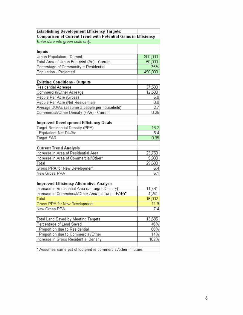
8