transportation planning and mobility division€¦ · virginia department of transportation...
TRANSCRIPT
VIRGINIA DEPARTMENT OF TRANSPORTATION
TRANSPORTATION PLANNING AND MOBILITY DIVISION
INSTRUCTIONAL AND INFORMATIONAL MEMORANDUM
GENERAL SUBJECT:
Corridor Planning Studies – Arterial Management Plans
NUMBER:
IIM-TMPD-2.0
SPECIFIC SUBJECT:
Process for Conducting Planning Studies on the Arterial Preservation Network
DATE: 7/13/17
SUPERSEDES:
APPROVED: Marsha Fiol State Transportation Planner Approved ______7/13/17______
EFFECTIVE DATE
These instructions are effective as of July 13, 2017.
BACKGROUND
VTrans, Virginia’s Multimodal Transportation Plan for 2040, designates certain major highway facilities as Corridors of Statewide Significance (CoSS). In addition to the CoSS system, there are other highway facilities that are needed for statewide connectivity. These highways are functionally classified as Principal or Other Principal Arterials, and like the CoSS, are intended to accommodate long distance movements of people and goods. The viability of this system (the CoSS and the other Principal Arterials) is very important for Virginia’s economy as it provides both interstate and intrastate connectivity.
Arterial Preservation Network
The Arterial Preservation Network includes segments of selected facilities that are part of the
CoSS system or are functionally classified as Principal or Other Principal Arterials. Those
roadway segments selected for the Arterial Preservation Network are identified as follows:
“Mobility Preservation Segments” (MPS) – These are segments of arterial roadways
outside of urban areas (population of 50,000 or more) that serve a critical long
distance mobility function where no parallel Interstate/freeway route exists. VDOT’s
Instructional & Informational Memorandum IIM-TMPD-2.0 Sheet 2 of 13
focus on these highway segments will be to preserve the mobility by minimizing the
delays for through traffic whenever access changes are proposed.
“Mobility Enhancement Segments” (MES) – These are segments of Arterial roadways
inside of urbanized areas (population of 50,000 or more) where there may be
opportunities to improve traffic flow without major widening. These (MES) segments
often experience significant traffic growth due to the adjacent land development and
travel delay due to the proliferation of entrances and traffic signals that serve adjacent
land uses. MES segments generally also serve multiple modes of travel.
This Arterial Preservation Network is shown on a statewide map at this link.
PURPOSE/SCOPE/REQUIREMENTS
The primary function of the Corridors of Statewide Significance (CoSS) as well as the facilities that are classified as Principal Arterials is to serve long distance travel. In order for these corridors to continue serving this function, the ability of long distance travelers and goods to move safely and efficiently must be preserved and given priority over local access. The Commonwealth Transportation Board (CTB) has expressed the following goals for the Arterial Preservation Network:
1. Preserving the capacity on the MPS; 2. Enhancing the capacity on the MES; 3. Improving the operating efficiency; 4. Reducing the number of existing traffic signals; and 5. Minimizing the number of new traffic signals on these same facilities.
The purpose of this policy is to carry out the goals of the CTB through the development of Arterial Management Plans (AMP). The AMPs will include detailed studies of the existing conditions and operations of a corridor, soliciting input from stakeholders, gaining locality input to plan innovative and cost effective solutions to improve safety, operations, and mobility. The procedures outlined in this document shall be used when developing AMPs and other corridor studies on the Arterial Preservation Network; however, these procedures should also be used for corridor studies on Other Principal Arterials and Minor Arterials that are not part of the Arterial Preservation Network that are important for regional connectivity and mobility. Planned improvements shall minimize delay for through traffic without compromising the safety for local drivers and other road users. Current access and future access points must be evaluated, planned, and designed to minimize conflict points and delay for through traffic and provide safe access to adjacent land development. This policy is intended to preserve the Commonwealth’s transportation investments by guiding the development of Arterial
Instructional & Informational Memorandum IIM-TMPD-2.0 Sheet 3 of 13
Management Plans (AMP) that will allow localities and the Department to better manage and balance system performance with local access needs.
The Commonwealth Transportation Board has approved a Process for Studying Corridors of
Statewide Significance (CTB Policy on CoSS - page 3-116).
The CTB’s policy is the guidance document for corridor studies on the Corridors of Statewide
Significance (COSS) and developing Corridor Master Plans for the COSS. This IIM is
intended to give further instructions for the development of AMPs and other corridor studies
on the Arterial Preservation Network.
The following documents contain instructions and guidance on various elements that may be
incorporated in the AMPs and other corridor studies:
Appendix A of the Road Design Manual – with emphasis on laying the foundation for
Context Sensitive Solutions (CSS) - Common Sense Engineering (CSE) and Context
Sensitive Solutions to Transportation Challenges (IIM-LD-235) and Practical Design
Flexibility in the Project Development Process - Fundamentals of Common Sense
Engineering (IIM-LD-255).
Appendix F of the Road Design Manual (access management, intersections,
entrances, and crossovers)
Requirements for Signal Justification Reports (SJRs) For New and Reconstructed
Signals (IIM-TE-387)
The Manual on Uniform Traffic Control Devices (MUTCD) and the Virginia Supplement
to the MUTCD.
When Main Street Is a Highway: Addressing Conflicts between Land Use and
Transportation (VTRC Report 17-R13) – December 2016, Kayleigh M. Roy and Peter
B. Ohlms
Improving Collaboration and Consensus Building in the Coordination of Access
Management and Land Use in Corridor Planning (VTRC Report 15-R20) – June 2015,
Roger W. Howe
Traffic Operations and Safety Analysis Manual (TOSAM)
Based on the CTB’s goal of eliminating traffic signals where possible, all AMPs and corridor
studies on the Arterial Preservation Network shall evaluate existing traffic signals and
consider the following:
Can existing traffic signals feasibly and reasonably be consolidated using access
management or local road changes to allow traffic to access the signal at the
consolidated location?
Instructional & Informational Memorandum IIM-TMPD-2.0 Sheet 4 of 13
If existing signals are to remain, can the signal be feasibly and reasonably redesigned
to reduce the number of signal phases and maximize the amount of green time
allotted to the major street? This will involve the consideration and evaluation of
Alternative Intersection/Interchange (AI/I) designs.
Can the existing traffic signal feasibly and reasonably be eliminated, as per Part 4B of
the Virginia Supplement to the MUTCD? Signal “removal” could constitute simple stop
sign installation, or conversion of the intersection to a non-signalized Alternative
Intersection/Interchange (AI/I) configuration such as a roundabout or a Restricted
Crossing U-Turn (RCUT).
VDOT’s Junction Screening Tool (VJuST) should be used where applicable to
evaluate and screen feasible Alternative Intersection/Interchange (AI/I) configurations.
PROCEDURES
A corridor study may be initiated in several ways. Typically, a request for the study is sent
from a locality or regional planning organization (MPO/PDC) to the District
Engineer/Administrator/Planning Manager. After reviewing the request, the District
Engineer/Administrator/Planning Manager will forward the request to the Transportation and
Mobility Planning Division. Arterial Management Plans are often initiated by TMPD in
coordination with the respective district(s). The corridor study process starts by establishing a
study team. The CTB members that represent the District or the area are ex-officio
members of the study team, will be notified of the schedule and study progress and
any related meetings to facilitate their participation and involvement.
The study team shall be comprised of the following internal and external representatives and
are expected to attend all meetings (pending availability):
VDOT Study Team Members
District Planning Manager (usually the VDOT project manager)
Residency — Resident Engineer/Residency Administrator or ARE-LU
District Traffic Engineering and/or Regional Operations
District Location and Design
Central Office Transportation and Mobility Planning
External Study Team Members
Affected Localities
Regional Planning Organizations (MPO/PDC)
Instructional & Informational Memorandum IIM-TMPD-2.0 Sheet 5 of 13
The study team should also include the following representatives based on study needs:
VDOT
District Environmental
District Right of Way
Central Office Traffic Engineering (required at the appropriate stage if a new traffic signal is proposed)
Central Office Location and Design (required at the appropriate stage if new crossover is proposed or a new/modified access is proposed on a Limited Access Facility.
External
Federal Highway Administration (FHWA)
Department of Rail and Public Transportation
Regional & Local Transit
Stakeholders – (ex. civic groups, National Park Service, large employers,
transportation advocacy groups, etc.)
The corridor study team should begin by establishing a corridor vision and goals which
support the safe, efficient, and effective movement of people and goods. Engaging local
governments throughout the process is critical in two important respects:
1) to ensure that local objectives regarding access, mobility, economic development,
and aesthetic standards are considered and included appropriately in a
cooperative way that helps further statewide goals, and
2) to ensure that the CTB’s statewide goals in VTrans are reflected in local
comprehensive plans and land use decision-making.
The study team should meet at regular intervals to discuss key topics at the various stages of
the corridor study.
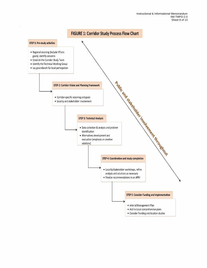
The Corridor Study Process Flow Chart (FIGURE 1) highlights the five main steps in the
corridor study process. These five steps are based upon the CTB Policy on CoSS Studies
(page 3-116), as previously referenced in this document. The study team will ensure that
input is captured from localities and stakeholders, and that all participants are working
constructively toward solutions that respect the legitimate goals of all involved.
STEP 1: Pre-study activities
Pre-study activities include: (a) establishing the corridor study team including a
technical work group, (b) gathering information from the Locality’s land use plan,
recently approved land rezoning or site plans, prior statewide planning efforts, such as
Instructional & Informational Memorandum IIM-TMPD-2.0 Sheet 6 of 13
VTrans and the Surface Transportation Planning process, that should be presented
through informative visual displays; (c) focusing specific analysis at the broad corridor
level and at some key geographic areas within corridor; and (d) establishing the
groundwork for participation in the study, including local and stakeholder participation.
STEP 2: Corridor Vision and Planning Framework
The Corridor visioning involves the collaborative efforts of VDOT, the Locality, DRPT,
and other stakeholders to apply the statewide goals of VTrans to the specific corridor,
and developing potential strategies that respect the Locality and stakeholder
objectives. Additional input will be sought through meetings with individual or groups
of stakeholders and through public meetings in accordance with the Public
Participation in Virginia’s Transportation Planning and Programming Process
guidebook.
STEP 3: Technical Analysis The technical analysis must ensure that an appropriate evaluation of the traffic
demand and operations is made for a particular location or area. The level of the
analysis will be based on the intensity of current and future traffic demands. Technical
analyses will include the collection of traffic data in accordance with the Traffic
Operations and Safety Analysis Manual (TOSAM), conducting field reviews and
stakeholder interviews, analysis of existing conditions (e.g. land use, crash analysis,
access conformance as per VDOT’s Access Management Regulations, traffic
operations), and development of traffic volume forecasts consistent with regional or
statewide forecasting procedures. Regardless of the methodology used, all traffic
forecasts developed for the corridor study must be recorded in the Statewide Planning
System by contacting VDOT Transportation and Mobility Planning Division. The
analysis will identify all issues that need to be addressed and resolved. Alternatives
will be developed, analyzed and evaluated in accordance with TOSAM, with emphasis
on creative, cost effective and context sensitive design solutions.
Common Sense Engineering and Context Sensitive Designs will be employed in the
consideration/evaluation of alternatives. Alternatives should optimize the existing
roadway capacity through methods such as operational improvements, access
management, Alternative Intersection/Interchange (AI/I) designs, turn lanes, and
technology/signal operation improvements to facilitate mobility at existing signals as
well as Transportation Demand Management (TDM) before recommending additional
capacity through roadway widening. TDM strategies include but are not limited to
Park & Ride Lots, transit, bicycle/pedestrian facilities, and employer outreach for
flexible work schedules and telework opportunities. New signals at currently non-
signalized intersections shall be evaluated in accordance with IIM TE-387 and the
Virginia Supplement to the MUTCD. Results of these evaluations will be shared with
stakeholders at public meetings.
Instructional & Informational Memorandum IIM-TMPD-2.0 Sheet 7 of 13
STEP 4: Coordination and Study Completion
Coordination efforts include workshops and meetings with local governments and
stakeholders to explain the technical analysis and the preliminary recommendations
for the corridor. The study team must facilitate the discussions on solutions to ensure
that the input from all participants is considered in developing the final
recommendations. The corridor study will then be documented in the form of an
Arterial Management Plan.
STEP 5: Project Advancement and Implementation
Many of these activities occur after the formal corridor study is incorporated into an
Arterial Management Plan for this MPS or MES.
o Local government activities include adopting the Arterial Management Plan,
revising local comprehensive plans, and identifying possible local sources of
funding.
o Regional agency activities include updating regional planning documents (e.g.,
Constrained Long Range Plan, Rural Long Range Plan), and identifying any
possible regional funding options.
o State –VDOT/DRPT activities include the incorporation of the AMP (after Local
adoption) in state planning documents (e.g. VTrans), updating the Statewide
Planning System, identifying state and federal funding options, performing
detailed location studies, and ultimately, project construction and/or
improvements to highway, transit and rail services. State implementation may
also include non-construction recommendations, such as new policies, rules or
procedural changes.
These represent the broad steps for the development of corridor studies and AMPs along the
Arterial Preservation Network; however, each study should be designed for the unique
characteristics of the study corridor. If there is an existing safety need, the corridor study
should follow the Fundamentals of Common Sense Engineering as outlined in IIM-LD-255. In
cases where a study corridor is relatively undeveloped but is anticipated to develop or is
planned for redevelopment based on the future land uses identified in the locality’s
Comprehensive Plan, the corridor analysis must consider those planned land use changes.
Instructional & Informational Memorandum IIM-TMPD-2.0 Sheet 8 of 13
Instructional & Informational Memorandum IIM-TMPD-2.0 Sheet 9 of 13
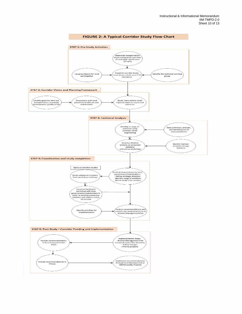
A key point illustrated by the flow chart is the involvement of local governments and other
stakeholders in the development of an effective corridor management plan and investment
strategy.
The corridor study team will meet with the elected leaders and Locality staff early in the
process in order to reach an understanding of corridor interests and to capture local priorities.
These might be special meetings or regular meetings of board or planning commissions or
transportation committees. The goal is to engage local officials throughout the corridor study
process. Beginning at the initiation of the study, the study team should encourage
communication with elected leaders and collaboration specifically where special issues, such
as congestion relief, unique safety needs, historical and cultural resources or specific growth
pressures exist.
Specific recommendations are likely to be adjusted throughout the study to reflect technical
and planning considerations, changing needs and conditions. The study team should use
area maps with overlays as well as other displays that may be needed for the participants to
clearly understand the issues and impacts.
It is important that VDOT and local study team representatives keep all stakeholders
informed and seek common ground to achieve transportation goals. The study process must
be designed to maximize the constructive cooperation of all involved. This cooperation will
promote buy-in to the plan which is critical for implementation and effectiveness.
The technical processes and procedural steps for corridor studies are well-established and
documented in NCHRP Report 435, Guidebook for Transportation Corridor Studies. See
FIGURE 2 for A Typical Corridor Study Flow Chart on the technical process. Using the
Figure 2 flow chart as a guide, the Study Team will meet with stakeholders to develop the
study outline and scope of work to address the long term planning vision as well as any
issues that may be unique to the corridor.
Instructional & Informational Memorandum IIM-TMPD-2.0 Sheet 10 of 13
Instructional & Informational Memorandum IIM-TMPD-2.0 Sheet 11 of 13
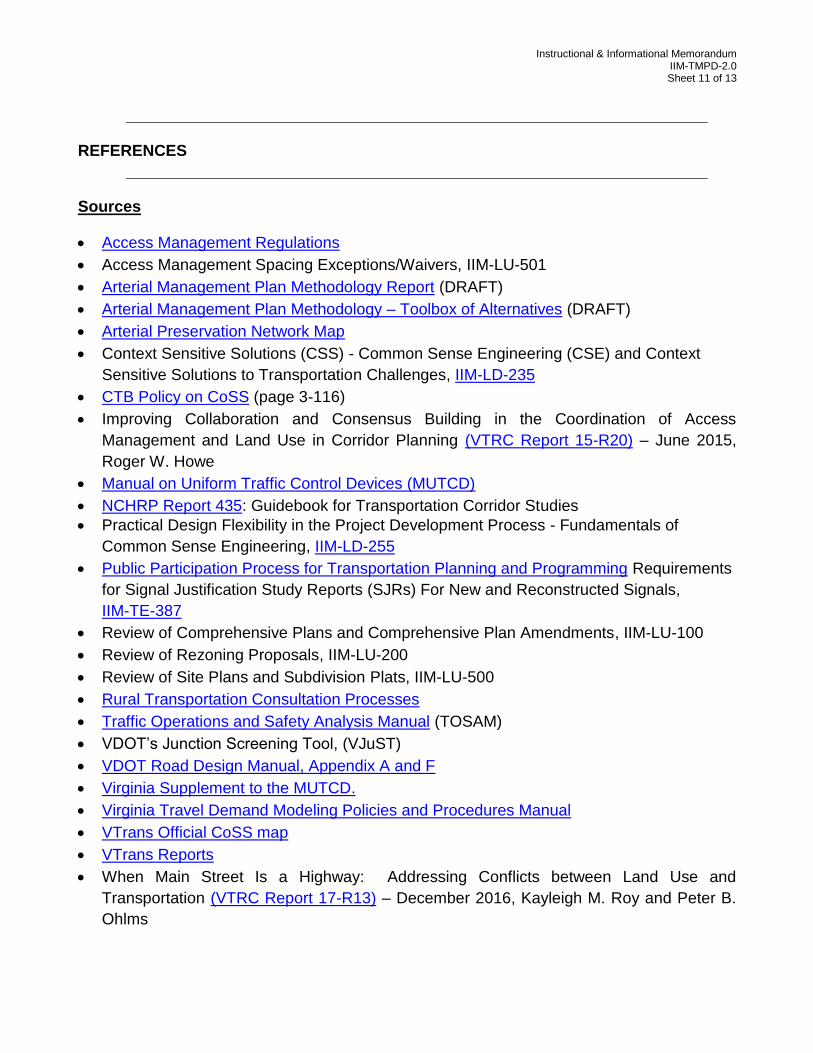
REFERENCES
Sources
Access Management Regulations
Access Management Spacing Exceptions/Waivers, IIM-LU-501
Arterial Management Plan Methodology Report (DRAFT)
Arterial Management Plan Methodology – Toolbox of Alternatives (DRAFT)
Arterial Preservation Network Map
Context Sensitive Solutions (CSS) - Common Sense Engineering (CSE) and Context
Sensitive Solutions to Transportation Challenges, IIM-LD-235
CTB Policy on CoSS (page 3-116)
Improving Collaboration and Consensus Building in the Coordination of Access
Management and Land Use in Corridor Planning (VTRC Report 15-R20) – June 2015,
Roger W. Howe
Manual on Uniform Traffic Control Devices (MUTCD)
NCHRP Report 435: Guidebook for Transportation Corridor Studies
Practical Design Flexibility in the Project Development Process - Fundamentals of
Common Sense Engineering, IIM-LD-255
Public Participation Process for Transportation Planning and Programming Requirements
for Signal Justification Study Reports (SJRs) For New and Reconstructed Signals,
IIM-TE-387
Review of Comprehensive Plans and Comprehensive Plan Amendments, IIM-LU-100
Review of Rezoning Proposals, IIM-LU-200
Review of Site Plans and Subdivision Plats, IIM-LU-500
Rural Transportation Consultation Processes
Traffic Operations and Safety Analysis Manual (TOSAM)
VDOT’s Junction Screening Tool, (VJuST)
VDOT Road Design Manual, Appendix A and F
Virginia Supplement to the MUTCD.
Virginia Travel Demand Modeling Policies and Procedures Manual
VTrans Official CoSS map
VTrans Reports
When Main Street Is a Highway: Addressing Conflicts between Land Use and
Transportation (VTRC Report 17-R13) – December 2016, Kayleigh M. Roy and Peter B.
Ohlms
Instructional & Informational Memorandum IIM-TMPD-2.0 Sheet 12 of 13
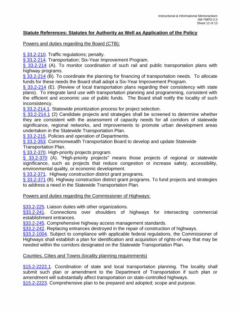
Statute References: Statutes for Authority as Well as Application of the Policy Powers and duties regarding the Board (CTB): § 33.2-210. Traffic regulations; penalty. § 33.2-214. Transportation; Six-Year Improvement Program. § 33.2-214 (A). To monitor coordination of such rail and public transportation plans with highway programs. § 33.2-214 (B). To coordinate the planning for financing of transportation needs. To allocate funds for these needs the Board shall adopt a Six-Year Improvement Program. § 33.2-214 (E). (Review of local transportation plans regarding their consistency with state plans). To integrate land use with transportation planning and programming, consistent with the efficient and economic use of public funds. The Board shall notify the locality of such inconsistency. § 33.2-214.1. Statewide prioritization process for project selection. § 33.2-214.1 (2) Candidate projects and strategies shall be screened to determine whether they are consistent with the assessment of capacity needs for all corridors of statewide significance, regional networks, and improvements to promote urban development areas undertaken in the Statewide Transportation Plan. § 33.2-215. Policies and operation of Departments. § 33.2-353. Commonwealth Transportation Board to develop and update Statewide Transportation Plan. § 33.2-370. High-priority projects program. § 33.2-370 (A). “High-priority projects" means those projects of regional or statewide significance, such as projects that reduce congestion or increase safety, accessibility, environmental quality, or economic development. § 33.2-371. Highway construction district grant programs. § 33.2-371 (B). Highway construction district grant programs. To fund projects and strategies to address a need in the Statewide Transportation Plan. Powers and duties regarding the Commissioner of Highways: §33.2-225. Liaison duties with other organizations. §33.2-241. Connections over shoulders of highways for intersecting commercial establishment entrances. §33.2-245. Comprehensive highway access management standards. §33.2-242. Replacing entrances destroyed in the repair of construction of highways. §33.2-1004. Subject to compliance with applicable federal regulations, the Commissioner of Highways shall establish a plan for identification and acquisition of rights-of-way that may be needed within the corridors designated on the Statewide Transportation Plan. Counties, Cities and Towns (locality planning requirements) §15.2-2222.1. Coordination of state and local transportation planning. The locality shall submit such plan or amendment to the Department of Transportation if such plan or amendment will substantially affect transportation on state-controlled highways. §15.2-2223. Comprehensive plan to be prepared and adopted; scope and purpose.
Instructional & Informational Memorandum IIM-TMPD-2.0 Sheet 13 of 13
§15.2-2223 (B.3) The transportation plan and any amendment shall be consistent with the Commonwealth Transportation Board’s Statewide Transportation Plan, Six-Year Improvement Program, and the location of routes. § 15.2-2223 (B.4) Prior to adoption of the transportation plan or any amendment the locality shall submit such plan or amendment to the Department. § 15.2-2223.1. Comprehensive plan to include urban development areas. Any locality may amend its comprehensive plan to incorporate one or more Urban Development Area(s). § 15.2-2224. Surveys and studies to be made in preparation of plan; implementation of plan. § 15.2-2230. Comprehensive Plan to be reviewed every five years. § 15.2-2232. Legal Status of the Plan. Each local government through which one or more of the designated Corridors of Statewide Significance traverses, shall, at a minimum, note such corridor or corridors on the transportation plan map.