transportation in michigan history · • 15!1~ u transportation in michigan history transportation...
TRANSCRIPT
TRANSPORTATION
IN MICHIGAN HISTORY
SESQUICENTENNIAL SERIES
1987

TABLE OF CONTENTS
1. Indians Started Road from Footpaths to Freeways
2. Sled Dogs Carried Supplies, Mail in Early-Day Michigan
3. Plank Roads Were the Rage in 19th Century Michigan
4. "King Mud" Once Ruled the Roads
5. Michigan -- A State of Highway "Firsts''
6. Bicyclists Led the Way to Good Highways
7. Old Chicago Road, Now I-94, is Still Michigan Main Street
8. Poor Signing Made it Tough to Get from Here to There
9. Motorists Once Free-Wheeled Without Licenses
10. Iron Truss Bridges are a Disappearing Breed
11. Busy Ferry Fleet Preceded Mackinac Bridge

15!1~ • u
TRANSPORTATION IN MICHIGAN HISTORY
TRANSPORTATION IN MICHIGAN HISTORY
INDIANS STARTED ROAD FROM FOOTPATHS TO FREEWAYS
By Philip P. Mason
T~ey didn't know it at t~e time, but Indians were Michigan's
~irst highway route location encineers. With few exceptions,
the state's modern hig!"lways follow the course of the trails of
the Indians who roamed the wilderness several thousand years
before the coming of the white man.
These paths, worn deep by centuries of foot travel by the
Indians, were located on high, dry ground along watersheds and
streams. They connected main Indian villages and led to the
rich hunting and fishing grounds of thP. region now known as
Michigan. They linked the numerous rivers which covered the
area, thus providing a continuous transportation system. Indian
war parties used the trails in their attacks on enemy tribes and
the villages and forts of the British and Americans.
Convenient Paths
Some of the Indian trails that criss-crossed ~1ichigan were
segments of we 11-known trails connecting the Atlantic seaboarc
and the plains states. Explorers, missionaries and fur traders
used these convenient paths as they traveled westward to
penetrate the frontier. Later, they provided a way through the
wild country for thousands of settlers who poured into Michigan
to carve out homes in :he ~1:jerness.

-2-
These trails should not be confused, however, with modern
highways or even the crude wagon roads built by the early
settlers. An Indian trail was merely a narrow path, about 12 to
18 inches wide, ;:>ermitting only single-file travel. This gave
the tribesmen some protection against surprise attack or ambush
and spared them the tedious job of clearing a <,;ider path. i •
was not until the coming of the white settlers, laden wit!":
supplies, that the trails were improved.
Paths Expanded
The use of the pack horse was the first step in the process
of widening the pathways. Branches and bushes were broken off
from each side of the trail and soon it was several feet wide,
Later, when white settlers flocked to Michigan territory,
bringing their possessions by oxen-drawn wagons, there was a
need for even wider roads.
Rising to the call for aid, Congress appropriated funds for
the survey and improvement of roads in the territory. Such road
as low as
logs, and
work consisted of cutting down trees
possible, filling the low and swampy
and bushes
areas with
draining water holes. Even with improvements these roads soon
developed ruts, and wagon travel was slow and sometimes
dangerous. Decades passed before good gravel roads came into
use. Indeed, it was nearly a century before paved roads were
built in Michigan. •Great Sauk Trail•
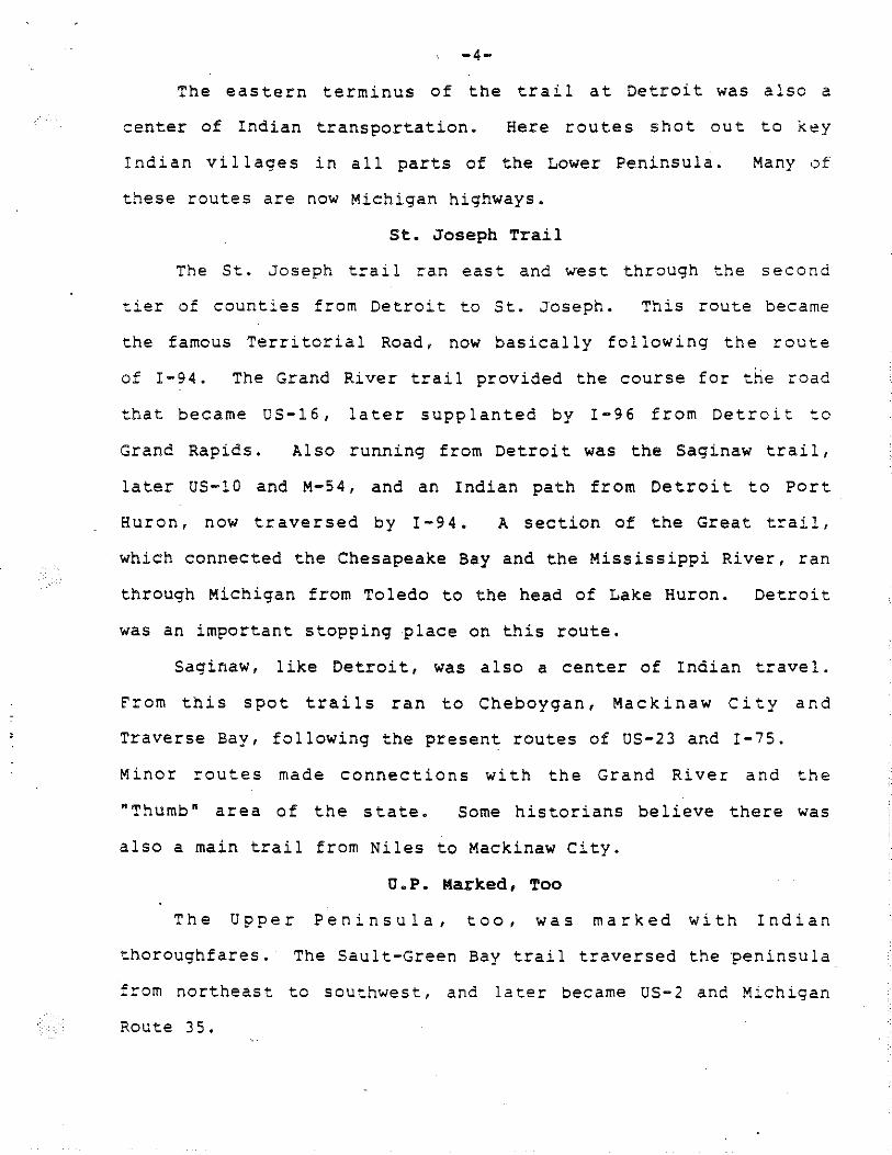
The most famous Indian ~rail in Michigan was the Great Sauk
trail, which ran from De~~~l~ ~o C!"::caco. Now US-12, this route
-3-
was in use centuries before the discovery of America. It is
believed to have been first.beat out of the wilderness by great
herds of buffalo and other animals which roamed the Lower
Peninsula.
Later, tribes of Chippewas, Potowatomi, Sauks and Fox, and
other Indians of Wisconsin, Illinois and Michigan used the trail
for the annual trips to Fort Malden, near Amherstburg, Ont., to
receive gifts from the English government. It was used by_ these
tribes in their attacks on Detroit during the American Revolution
and the War of 1812.
The Great Sauk trail was first improved in the 1830s.
Largely as a result of the activities of Father Gabriel Richard,
Michigan Territory's delegate, Conqress authorized the survey
of a road from Detroit to Chicago in 1824.
At first, surveyors planned to build the road in a straight
line between the two cities. When the plan proved impractical,
they decided to follow the well-marked Sauk trail, which bypassed
swamps, lakes and other natural obstacles to good travel. Thus,
the Chicago Road, or OS-12, as it was later called, came into
being.
Other important trails intersected the Great Sauk trail at
various points. Near Niles, where it crossed the St. Joseph
River, other trails ran from it to all parts of Michigan and
Indiana. From the head of Lake Michigan, a trail ran through
Illinois to the Mississippi ~iver.
-4-
The eastern terminus of the trail at Detroit was also a
center of Indian transportation. Here routes shot out to k~y
Indian villages in all parts of the Lower Peninsula. Many •Jf
these routes are now Michigan highways.
St. Joseph Trail
The St. Joseph trail ran east and west through the second
tier of counties from Detroit to St. Joseph. This route became
the famous Territorial Road, now basically following the route
of I-94. The Grand River trail provided the course for the road
that became US-16, later supplanted by I-96 from Detroit to
Grand Rapids. Also running from Detroit was the Saginaw trai 1,
later US-10 and M-54, and an Indian path from Detroit to Port
Huron, now traversed by I-94. A section of the Great trail,
which connected the Chesapeake Bay and the Mississippi River, ran
through Michigan from Toledo to the head of Lake Huron. Detroit
was an important stopping place on this route.
Saginaw, like Detroit, was also a center of Indian travel.
From this spot trails ran to Cheboygan, Mackinaw City and
Traverse Bay, following the present routes of US-23 and I-75.
Minor routes made connections with the Grand River and the
"Thumb" area of the state. Some historians believe there was
also a main trail from Niles to Mackinaw City.
O.P. Marked, Too
The Upper Peninsula, too, was marked with Indian
thoroughfares. The Sault-Green Bay trail traversed the peninsula
from northeast to southwest, and later became US-2 and Michigan
Route 35.
-s-The Old Mackinac trail, which ran from the Sault to St.
Ignace, is now OS-2. There were several important trails in the
western part of the peninsula. Michigan Route 26, which divides
the Keweenaw Peninsula, was used for thousand of years by Indians
in their migration to the rich copper deposits of the area.
L'Anse, too, was a center of Indian activity and from this spot
spread numerous trails, including the Lac Vieux Desert trail,
which followed present OS-141.
The L'Anse-Marquette Indian trail, which in turn became
US-41, and Route 35 from Marquette to Escanaba, which follows
the old Carp River trail, are two other Opper Peninsula highways
with historic beginnings.
In addition to well-known Indian trails, hundred of smaller
trails in all parts of- the state were used by early settlers.
In time, many of them became state highways.
Traces of the original Indian trails have now all but
vanished from our landscape. Only in our imagination can we
visualize the appearance of these narrow, foot-trod paths and
the Indians who made and used them.
(Dr. Phi lip P. Mason University and has transportation.)
U#
is a professor of history at Wayne State a special interest 1n the history of
Contact: Public Information Office, Michigan Department of Transportation, P.O. Box 30050, Lansing, :-II 48909. (Phone: 571/373-2160)

Long before Michigan became , .s::a::e, ·Indians beat do.vm the narrow foot trails that basically .set the course fo~ many modern highways.

ST, .._.,.. Clf££X
1-=- -,·--- .... -- I:JIIII· tr ........ l ' '
-------'---_I_
Michigan's 1,180-mile Interstate Freeway system, started in 1956 and now nearly complete, rese~oles the network of early Indian trai:~.
IONIA, Ml
SENTINEL-STANDARD E-4,770
JAN-12-67
Indians started roads: I .
from paths to freeways By Philip P. Mason Professor of History Wayne State University
DETROIT - They didn't know it at the time, but Indians were Michigan's first highway . route location engineers. ·
With few exceptions, the state's modern highways follow the course of the trails of the Indians who roamed the wilderness several thousand years before the coming of the white man.
These paths, worn deep by cen· turies of foot travel by the Indians, were located on high, dry ground alongwatel"Jheds and streams. They connec!AHI main Indian villages and led to the rich hunting and fishing grounds of the region now known as Michigan.
THEY LINKED the numerous rivers which covered the area, thus providing a continuous tran· sportation system. Indian war parties used the trails in their at· tacks on enemy tribes and the villages and forts of the British and Americans.
CONVENIENT PATHS Some of the Indian trails that
criss-crossed Michigan were segments of well-known trails connecting the Atlantic seaboard and the plains states. Explorers, missionaries and fur traders used these convenient paths as they traveled westward to penetrate the frontier. Later. they provided a way through the wild country for thousands of settlers who poured into Michigan to carve out homes in the wilderness.
THESE TRAILS should not be confused, however, with modern highways or even the crude wagon roads built by the early settlers. An Indian trail was- merely a narrow path, about 12 to 18 inches wide, permitting only single-file travel.
This gave the tribesmen some protection against surprise attack or ambush and spared them the tedious job of clearing .a wider path. It was not until the coming of the white settlers, laden with supplies, that the trails were improved.
PATHS EXPMIDEI).-The use of the P'l"k horse"was the
first step in the process of widening the pathways. Branches and bushes were broken off from each side of the trail and soon it was several feet wide. Later, when white settlers flocked to Michigan territory. bringing their possessions by oxEmdrawn wagons, there was a need for even wider roads.
Rising to the call for aid, Congress appropriated funds for the survey and improvement of roads in the territory. Such road work consisted of cutting down trees and bushes as low as possible, filling the tow and swampy areas with logs, and draining water holes.
Even with improvements these roads soon developed ruts, and wagon travel was slow ans sometimes dangerous. Decades passed before good gravel roads came into use. Indeed, it was nearly
a century before paved roads were built in Michigan.
"GREAT SAUK TRAIL" The most famous Indian trail in
Michigan was the Great Sauk trail, which ran from Detroit to Chicago. Now US-12. this route was in use centuries before the discovery of America. It is believed to have been first beat out of the wilderness by great herds of buffalo and other animals which roamed the Lower Peninsula.
Later, tribes of Chippewas, Potowatomi, Sauks .Jind Fox, and other Indians of Wisconsin, Illinois and Michig~o used .the~ trailfor the annual trips to. FoPi"Malden, near Amherstburg, Ont., to receive gifts from the English government.
IT W i\S used by these tribes in their attacks on Detroit during the American Revolution and the War of 1812.
The Great Sauk trail was first improved in the 1830s. Largely as a result of thl' activities of Father Gabriel Richard, Michigan Territory's delegate, Congress authorized the survey of a road from Detroit to Chicago in 1824.
At first. surveyors planned to build the road in a straight line between the two cities. When the plan proved impractical, they decided to follow the well-marked Sauk.irail .. which bypassed swamps,
(More)

lakes and other natural obstacles to good travel. Thus, the Chicago Road, or US-12, as it was later called, came into being.
OTHER IMPORTANT trails intersected the Great Sauk trail at various points. Near Niles, where it crossed the St. Joseph River, other trails ran from it to all parts of Michigan and Indiana. From the head of Lake Michigan, a trail ran through Ulinois to the Mississippi River.
The eastern terminus of the trail at Detroit was also a center of Indian transportation. Here routes shot out to key Indian villages in all parts of the Lo-:.~1' Peninsula. Many '6f these routes are now M~hj_@p highways.
ST. JOSEPH TRAIL The St. Joseph trail ran east and
west through the second tier of counties from Detroit to St. Joseph. This route became the famous Territorial Road, now basically following the route of I-94.
The Grand River trail provided the course for the road that became US-16, later supplanted by I-96 from Detroit to Grand Rapids. Also rUnning from Detroit was the Saginaw trail, later US-10 and M-54, · and an Indian path from Detroit to Port Huron, now traversed by l-94.
A SECTION of the Great trail, which connected the Chesapeake
Bay and the Mississippi lt1ver, ran through Michigan from Toledo to the head of Lake Huron. Detroit was an important stopping place on this route.
Saginaw, like Detroit, was also a center of Indian travel. From this spot trails ran to Cheboygan, Mackinaw City and Traverse Bay, following the present routes of US-23 and 1~75. Minor routes made con~ nections with the Grand River and the "Thumb" area of the state. Some historians believe there was also a main trail from Niles to Mackinaw City.
U.P. MARKED, TOO The Up~~r Peninsula, too, was
marked with Indian thoroughfares . The Sault-Green Bay trail traversed the peninsula from northeast to southwest, and later became US-2 and Michigan Route 35.
The Old Mackinac trail, which ran from the Sault to St. Ignace, is now US~2. There were several important trails in the western part of the peninsula. Michigan Route 26, which divides the Keweenaw· Peninsula, was used for thousand of years by Indians in their migration to the rich copper deposits of the area.
L'ANSE, TOO, was a center of Indian activity and from this spot spread numerous trails, including the Lac Vieux Desert trail, which followed present US-141.
The L'Anse-Marquette Indian trail, which in turn became US-41, and Route 35 from Marquette to Escanaba, which follows the old Carp River trail, are two other Upper Peninsula highways with historic beginnings.
In addition to well-known Indian trails, hundred of smaller trails in all parts of the state were used by early settlers. In time, many of them became state highways.
Traces of the original Indian trails have now all but vaniShed from our landscape. Only in oui- imagination can we visualize the appearance of these narrow, foot-trod paths and ~he Indians who made and used them.
(More)

long before Michigan became a state, before Europeans even visited the state, ! Native Americans beat down the narrow foot trails that basically set the course for
many modern highways. \
(More)

Mops courtesy Michigan Deportment of Transportation
Michigan's 1,180 miles in the Interstate Freeway system were put into construction in 1956. Now nearly complete, the freeway system resembles the network of early Native American trails.

TRANSPORTATION IN MICHIGAN HISTORY
Following is a~other in a series of art~cles on i~terest:~g
aspects of transportation in Michigan history. They are beino cistr~buted every few weeks as part of the Sesquicentenn:al celebration marking Michigan's lSOth year of statehood.)
TRANSPORTATION IN MICHIGAN HISTORY
SLED DOGS CARRIED SUPPLIES, MAIL IN EARLY-DAY MICHIGAN
By A. cecil Boughton
Up the ice-covered Grand River in the winter of 1837 came a
team of harnessed cogs pulling a sled which c·ontained an unusual
cargo. They were hauling a printing press from Grand Haven into
the Gr.and Rapids area for the newly established "Grand River
Times," Kent County's first newspaper.
The first issue was published on April 18, less than three
months after Michigan became the 26th state to enter· the Union.
But for those sturdy dogs, the task of moving a heavy piece
of equipment would have been much more difficult in a period
when overland travel was slow and often hazardous.
The role of oxen and horses in Michigan's early
transportation h·istory is well known, but dogs also made a
significant contribution.
Archaeologists conclud.e that Indians have been in Michigan
since 11,000 b.c. and that the dog was their first domesticated
animal. Through the successive trades with other tribes to the
southwest, they eventually obtained horses, which were originally
brought to America by the Spanish conquistadors in the 1500s.
Indian tribes reckoned their history from the time they
-2-
acquired the horse--which they called "the big dog"--and referred
to what went before as "the dog days." Dogs were used for
moving camp, hauling the Indians' personal belongings on their
backs, ;:>ull ing loaded travo is in the summer and to·boggan-ty;:>e
sleds in the winter.
Historical records confirm that the early ;:>ioneers in
Michigan adopted many Indian waY:s, including the use of dogs for
transportation. In territorial days and the early years of
statehood, the mail was carried, on a regular route, all the way
from Detroit to Sault Ste. Marie, via dog teams.
A· Presbyterian missionary at the Soc in 1831 noted how the
winter mails moved: "Two men on snowshoes drove dogs hitched to
a toboggan, which carried a tent, blankets, food and a bag of
mail. They went to the Straits, crossed the ice, and then went
all the way down to Saginaw and Detroit •••. In a month or two,
they would come back with news from the 'outside.'"
It is recorded that when a u.s. Post Office was established
in Alpena, the first mail arrived on Jan. 17, 1858, drawn on a
train pulled by three dogs following the shore of Thunder Bay on
Lake Huron.
"The mail came regularly once a week in winter," the
historian wrote, "while the only chance for mai 1 in the summer
was in case someone· 'went below.'"
Records also indicate that the first white people in the
western Upper Peninsula received their mail via dog team from
Green Bay, Wis. Even as late as the 1930s, there was a dog team

-3-
mail route in the eastern Upper Peninsula from the Whitefish
Point post office to the Vermillion Coast Guard station. ~ruman
"Doc" McLean used five d-ogs to carry the mail, groceries,
passengers, medicine and tools.
Photos, prints and drawings, as well as written records,
document the use of dog trains for carrying mai 1, supplies and
information between remote outposts.
A photo taken at the Straits of Mackinac in 1880 shows a
team of three dogs pulling a sleigh, providing regular
communication across the frozen waterway that separates the two
peninsulas. Another photo shows a Rev. w. Poyseor traveling via
dog sled to the congregations in his district--the lumber camps
of the Upper Peninsula.
Today, dog teams are used for sport instead of for work.
Racing dogs include Siberian huskies, Alaskan malamutes, Alaskan
Indian dogs and Samoyeds. They can travel up to 35 or 40 miles
an hour on a well-packed trail, but average 18 or 19 mph, partly
depending on the terrain and snow depth.
The first documented sled dog race in Michigan was a
children's competition in Ishpeming in 1910, with each child
running one dog. That was only three years after the first race
held in Alaska, a state that is now the locale of the famed
1,049-mile Iditarod race.
The sport of sled dog racing began to catch on in Michigan
in 1959 and spread to other states. Eight competitions are
scheduled through March 1, 1987, in locations ranging from
• -4-
Battle Creek in the south to Newberry in the Upper Peninsula.
In Michigan's Sesquicentennial year, they will highlight
the contribution of dog transportation through much of i'::s
history as a state.
#U
(A. Cecil Houghton of Grand Rapids is a sled dog racer and founder of the Great Lakes Sled Dog Association and the International Sled Dog Racing Association.)
-o-Following is a list of sled dog races scheduled in Michigan
this winter:
Jan. 3 and 4, Muskegon and Grand Rapids; Jan. 10-11, Gun Lake, west of Hastings1 Jan 17-18, Kalkaska and Bay City; Jan. 24 and 25, Grand Valley State College, Allendale; Jan. 31 and Feb. 1, Ft. Custer, Battle Creek;. Feb. 21 and 22, Traverse City (Ranch Rudolph) 1 Feb. 2 8 and 2 9, Newberry and Evart east of Reed City.
Earlier, races were held at Harrison Dec. 27 and 28.
U#
Contact: Public Information Office, Michigan Department of Transportation, P.O.Sox 30050, Lansing., Mich. 48909. (Phone 517/373-2160)
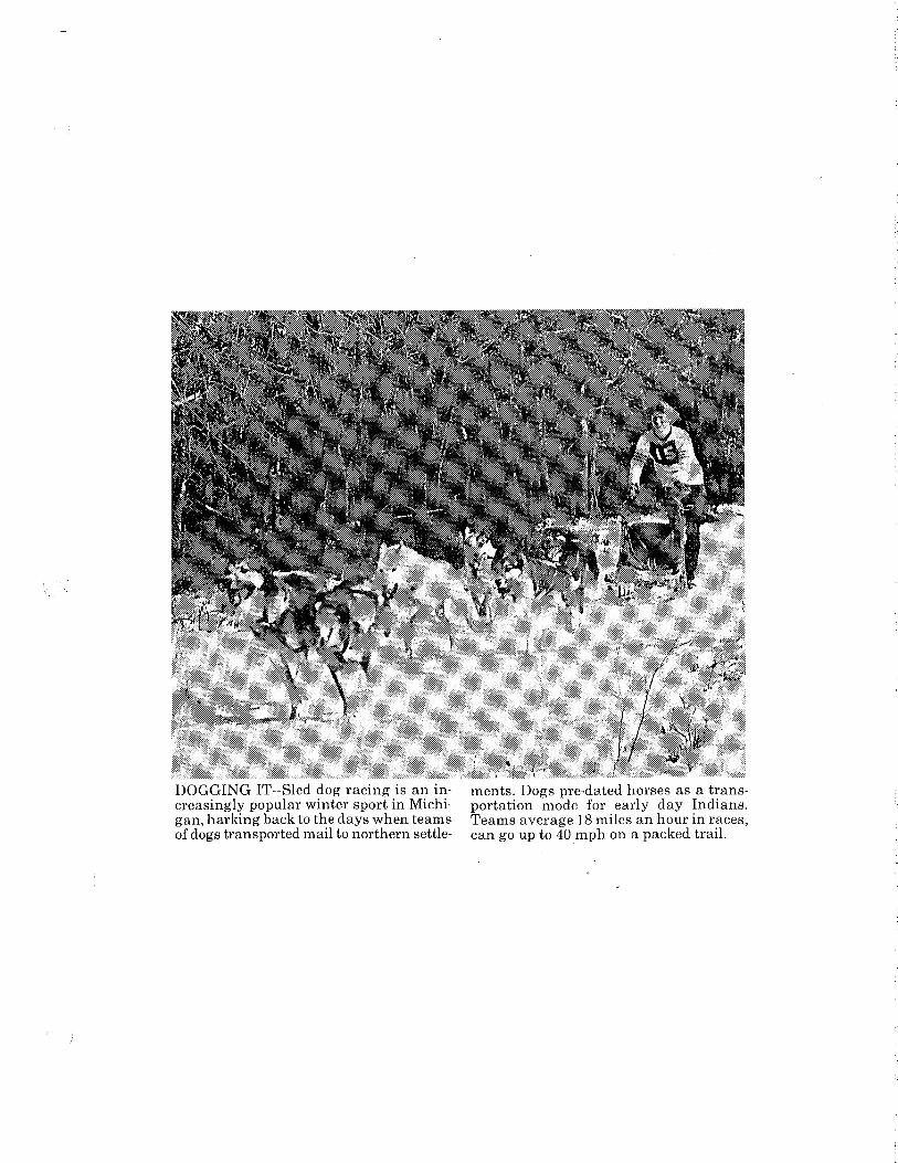
DOGGING IT--Sled dog racing is an increasingly popular winter sport in Michigan, harking back to the days when teams of dogs transported mail to northern settle-
ments. Dogs pre-dated horses as a transportation mode for early day Indians. Teams average 18 miles an hour in races, can go up to 40 mph on a packed trail.

Lansing State Journal • Sunday, Feb. 22, 1987
Sled dogs earned their keep in Michigan's earliest y~ar~.
Here, based on A. Cecil Houghton's research, is an accou~t of the role of sled dogs in MiChigan from the early years to today:
Up the ice-covered Grand River in the winter of 1837 came a team of harnessed dogs pulling a sled which contained an unusual cargo. They were hauling a printing press from Grand Haven into the Grand Rapids area for . the newly established Grand River Times, Kent C<?unty's first newspaper.
The first issue was published on April 18, less than three months after Michigan became the 26th state to enter the Union.
But for those sturdy dogs, the task of moving a heavy piece of equipment would have been
. much more difficult in a period when overland travel was slow and often hazardous. .
The role of oxen and horses m Michigan's early transportation history is well known, but dogs also made a significant contnbution.
Archaeologists conclude that · Indians have been in M1ctugan since 11,000 B.C. and that the do_g was their first domesticated ammal. Through the successive trades with other tribes to the southwest, they eventually obtained horses, which were originally brought to America by the Spanish conquistadors in the 1500s.
Indian tribes reckoned their history from the time they acquired the horse - which they called "the big dog~· - and referred to what went before as "the dog days." Dogs were used for moving camp, hauling the Indtans' personal belongings on thejr backs, pulling loaded travois in the summer and toboggan-type sleds in the winter.
Records confirm that the early pioneers in Michi~n adopted many Indian ways, mcludmg the use of dogs for transportation. In territorial days and the early years of statehood, the mail was carried, on a regular route, all the way from Detroit to Sault Ste. Marie, via dog teams.
A Presbyterian missionary at the Soo in 1831 noted how the winter mails moved: "Two men on snowshoes drove dogs hitched to a toboggan, which carried a tent, blankets, food and a bag of mail. They went to the Strail!i~
.Crossed the Ire. and then went all the way· down to Saginaw and Detroit ... In a month or two, they would come back with news from the "outside."
It is recorded that when a U.S. Post Office was established in Alpena, the first mail artlveq on Jan. 17, 1858, drawn on a train pulled by three doss. fllllO\Ying the shore of Thunder Bay on Lake Huron.
"The mail came regularly once a week in winter," the hlsto- · rian wrote, "while the only chance for mail in the summer was in case someone 'went below.'"
Records also indicate that the first white people in the western Upper Peninsula received their mail via dog team from Green Bay, Wis. Even as late as the 1930s, there was a dog team mail route in the eastern Upper Peninsula from the Whitefish Point post office to the Vermillion Coast Guard station. Truman "Doc" McLean used five dogs to carry the mail, groceries, passengers, medicine and tools. . Photos, prints and drawings, as
well as written records, docu~ ment the use of dog trains for carrying mail, supplies and information between remote outposts.
A photo taken at the Straits of Mackinac in 1880 shows a team of three dogs pulling a sleigh, providing regular communica~ tion across the frozen waterway that separates the two peninsulas. Another photo shows a Rev. W. Poyseor traveling via dog sled ~
to the congregations in his district - the lumber camps of the Upper Peninsula.
Today, the dog teams are used for sport instead of for work. They can travel up to 35 or 40 miles per hour on a well-packed trail, but aYerage 18 or 19 mph, partly depending on the terrain and snow depth.
The first documented sled dog
race in Michigan was a chi!·: dren's competition in Ishpeming in 1910, with each child running one dog. That was only three years after the first race held in Alaska. a state that is now locale of the famed 1,049-mile lditafod• race.
The sport of sled dog racing began to catch on in Michigan in 1959 and spread to other states.
(Photo on next page)

Michigan. Department of Transportatiot:
Doug Houghton and a six-dog team speed along in a race. Dogs have provided vital transpor-tation in Michigan from prehistoric times until this century. . .
- -~- _,. ·:'·.
TRANSPO_RTATION IN MICHIGAN HISTORY
(Following is another in a series of articles ·on interesting aspects of transportation in Michigan history. They are being distributed every few weeks as part of the Sesquicentennial celebration marking Michigan's l50th year of statehood.) #3
TRANSPORTATION IN MICHIGAN HISTORY
PLANK ROADS WERE THE RAGE IN 19TH CENTURY MICHIGAN
By Philip P. Mason
Lansing was still a "city in the forest" in 1852, but its
settlers had cause for optimism as they gathered one hot July
afternoon at the Seymour House to await the arrival of a
stagecoach. It was not the first stage to arrive in the new
capital, nor was it the arrival of a celebrity which attracted
the· crowd. ·The occasion was the formal opening of t.he Lansing-
Howell Plank Road.
The ·stage was heard a mile away speeding over the new oak
planks, but it was not until it came into sight that the crowd
started cheering. In speeches which followed..,. James Seymour and
other prominent Lansing citizens predicted a •new ~ra• in travel
and transportation. The new road, which· joined the plank road
from Howell to Detroit, would end the control of "king mud," they
said, ~timulate the economy of Ingham County, and provide
Lansing's "first outlet to civilization.•
Other towns and cities all over Michigan, and indeed, the
rest of the country, were witnessing similar ceremonies, for the
construction of plank ro~ds had become a mania with the American
people. Michigan was one of· the leaders,. in fact, the first
.:.2-
plank road in the United States was built in this state.
Although the movement lasted only a few decades, it represented a
unique place in the development of Michigan's highway system.
construction of Plank Roads
Plank roads should not be confused with "corduroy" roads,
which also were popular in Michigan during the early 19th
century. The latter were made by placing logs, often of
different sizes, over a low or swampy area. Although depressions
were filled with gravel or with smaller logs,. the corduroyed road
was usually rough and sometimes even dangerous. Logs floated and
rolled in the liquid mud and horses were "frightened by the
unstable footings.•
Plank roads on .. the other hand, we:r;-e. made of boards, ?~nd as
long as they were p~operly maintained,·provided a smooth surface.
They were constructed by laying planks of pine or oak, eight to
16 feet long and three to four inches thick, across "sleepers" or
•stringers" which were placed parallel to the direction of the
road. Ditches were dug on either side of the road to provide
proper drainage.
First Plank Roads
Most highway authorit~es claim that the plank road was
introduced in this country in New York in 1844. They overlook
the conclusive evidence, however, that seven years earlier, in
1837, the Michigan State Legislature granted a charter to the
Oetroi t, Plymouth and Ann Arb!=>r Turnpike .Company for a "timber
road made of good, well-hewn timber.• 'The Legislature granted
-3-
similar charters to other ?rivate com?anies. In 1844, for
exam?le, it authorized .the construction of ?lank roads from
Detroit to Port Huron and from near Sylvania, Ohio, to
Blissfield, Mich. TWo years later, charters were given to the
Corunna ·and Nortnam?ton and the Marshall and Onion City Plank
Road com?anies.
So great had interest become in the construction of these
?rivately-operated turnpikes that in 1848 the State Legislature
?assed a general Plank Road Law. It was no longer necessary to
get a special charter from the Legislature in order to build and
O?erate a ?lank road. The new law ?rovided that any company
could. operate a plank road as long as it was constructed
according to certain specifications, namely, that the road be two
to four rods wide, 16 feet· of which was to be i•a good, smooth,
?ermanent road,· we.ll drained by ditches on either side." At
least eight feet of the road was to be covered with ?lank three
inches thick. The law also provided that no grades were to be
greater than one in ten and that the charters were to run for 60
years.
Plank Road Companies
Private control of ?lank roads, or turnpikes, as they were
commonly called, reflected the failure of state and local
governmental units to provide an adequate highway system.
Des?ite the tremendous influx of settlers to Michigan in the
decades after 1830 (the population rose from 31,640 in 1830 to
212,267 in 1840 and to 341,591 in 1850), the State of Michigan
-4-
did practically nothing to provide roads.
Local units of government made feeble attempts to build
_roads but the total results were hopelessly inadequate. Even the
program of the federal government failed to meet the needs of
Michigan settlers. Prior to 1837 Congress authorized the
construction of a number of "territorial" roads, ostensibly for
military reasons, but the construction of these roads proceeded
so slowly that they failed to assist settlement. Thus the task
of road construction fell by default to private corporations.
Financial support for the plank road companies came mainly
from local sources. Well-to-do farmers, manufacturers, merchants
and professional men invested in ~hese ventures. Prominent .
backers of the Detroi:t-Howe_ll _Plank Road company were Lewis· Cass,
Zachariah Chandler, ·Henry Ledyard, C. _H. and Frederic;k· Bush, C.
C ;. Trowbridge and other inf 1 uential Detroi ters. These men were
als.o stockholders in the Detroit-Mt. Clemens Plank Road co. The
Lansing-Howell Road was financed by James Turner, H. H. Smith and
James Seymour of Lansing and businessmen from Howell,
Fowlerville, Williamston and Okemos. Farmers along the way
contributed materials and labor for the road. Additional capital
was obtained from eastern capitalists.
The paid capital stock of the plank road companies. varied
greatly. Ninety thousand dollars was invested in the Detroit and
Howell Plank Road Co. and only one thousand dollars in a venture
in Sault Ste. Marie. Typical of the other company investments
were: Adrian and Bean Creek,- $24,000; Detroit and Birmingham,

-s-S24,ooo, Ann Arbor and Whitmore Lake, $12,000; Flint and
Fentonville, $18,000; Grand Rapids and Plainfield, $20,000;
Lansing and Howell, $44,457; and Ontonagon and Rockland, $20,000.
In all, $2,040,180 was invested in Michigan plank road companies.
Construction costs
The cost of building plank roads ranged from one to three
thousand dollars per mile, depending upon the co"ndition of the
road bed, accessibility of timber and gravel and the cost of
labor. Bridges over rivers and streams were costly and put a
heavy financial burden on the plank road companies. Toll houses
also were added to initial capital outlay. Some companies, like
the one which operated a road between Detroit and Mt. Clemens,
purchased· several stands of timber· and a lumber mill on th-e
Clinton River to guarantee an ·adequa:te supply of planks. Gravel
pits also were purchased by many companies.
Tolls
The Legislature not only set up specifications for the
construction of the plank roads, but. they regulated the tolls as
well. A charge of two cents a mile was made for a wagon or
carriage drawn by two horses, and one cent a mile for every sled
or sleigh so drawn. If more than two horses were used an
additional charge of three-quarters of a cent per mile for each
additional animal was levied. A toll of one cent per mile was
made for a vehicle drawn ·by one horse, as well as for a horse and
rider. Tolls of one-half cent a mile were levied for every score
cf~~cf'm!!=cattle, "1:w::x:Ei:sa
mile.

-6-
Popularity of Plank Roads
Despite the tolls, plank roads were extremely popular during
their heyday. As long as they were properly maintained they
were a great improvement over the dirt roads, which were
impassable during many weeks of the year. Trips which took from
four to six days on· dirt roads were cut by 10 to 14 hours over
plank roads.
Plank roads were as. popular in rural areas as in .towns and
cities. Farmers could carry greater loads. to market, and many
preferred to use the plank road rather than the railroad, which
was being introduced in the state during the 1830 1 s and 1840 1 s.
Plank roads, in fact, were often called "farmers railroads" by .
con~emporaries who mai~tained that competition from plank roads . . . .
would keep down railroad rates~
A total of 202 plank road· companies received charters in
Michigan during the nineteenth century •. The longest plank road
given a charter was to have run from Zilwaukee to Mackinaw City
via Traverse City, a distance of 220 miles. The shortest was a
one-mile plank road in sault Ste. Marie.
Detroit was the terminus of eight plank roads which spread
out like spokes in a wheel from the metropolis. Mt. Elliott,
Michigan, Grand River, woodward, Grati~t and Jefferson avenues
were once plank roads. Plank roads were extremely popular in
Grand Rapids where seven companies operated toll roads.
Monroe was another important center, with plank roads
running to Dearborn, Flat Rock, Newport and Saline. Lansing
plank roads connected Eaton Rapids, Mason, Howell, Ann Arbor and
. -7-
Jackson with.the capita~ city. Other cities with plank roads
were Adrian, Ann Arbor, Dexter, Flint, Hastings, Hillsdale,
Kalamazoo, Lapeer, Marshall, Niles, Ontonagon, Paw Paw, Plymouth,
Pontiac, Saginaw, Tawas City, Utica and Wyandotte.
Scores of other .plank roads were projected only on paper.
Of the 202 companies which obtained charters cnly 89 actually
built and operated plank roads: Indeed, of the 5,082 miles of
plank road authorized by the Legislature, only 1,179 miles were
every built.
Decline of the Plank Road
Despite the initial popularity of these roads and the hopes
of their promoters, the "plank road craze" did not last long.
The roads remained "in good condition for the first three or four
years; but a·fter t;hat they needed constant attention •. Plank·s
loosened, warped and decayed and had to be replaced often. It
was estimated that annual repairs cost from 20 to 30 percent of
the original cost of the road.
Toll ·houses had to be built and maintained and a· .full-time
superintendent employed throughout the year. Some road companies
had to buy and operate lumber mills. Moreover, toll income was
reduced by-the use of "shunpikes• --short stretches of road built
to avoid the toll gates.
Because of the high costs of lumber, some companies
substituted gravel as the planks decayed. Thus the road became a
combination of plank and gravel. This made travel difficult and,
in some cases, hazardous. It was the famous humorist Mark Twain
who left us the classic description of this type of road. Asked

-8-
how he liked his trip over the Kalamazoo and Grand Rapids Plank
Road, he replied, ""It would have been good if some unconscionable
·scoundrel had not now and then dropped a plank across it."
Another writer referred to a road in a similar condition as "an
enlarged washboard."
By 1900 only 23 of the original 89 plank roads were in
operation, and of these only a short stretch of Detroit-Howe 11
road was actually made of planks. In the first decade of the
20th century the remaining private roads, coming increasingly
under public scorn, were turned over to the state or purchased by
street railway companies.
(Dr. Philip P. Mason is a professor· of history at Wayne State University and h~s a special interest in' the history of transportation.)
Contact: Public Informatioi Office, Michigan Department of Transportation, P •. o. Box 30050, Lansing, MI 48909. (Phone: 571/373-2160)
--

TRAVELING IN STYLE-- Eighty-nine plank roads, like this one running to Detroit along the present route of Gratiot Avenue in Macomb County, were built in Michigan in the Nineteenth Century. They were made of boards of pine or oak, eight to sixteen feet long and three to four inches thick.
Monday, April 6, 1987 • OFFICIAL MICIDGAN
Sesqui Series
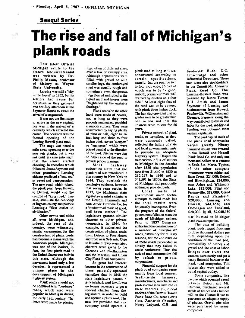
The rise and fall of Michigan's plank roads
Tbls latest Orflclal Michigan salute to the state's sesquicentennial was written by Dr. Pblltp Mason, professor of history at Wayne State University.
Lansing was still a "city in the forest" in 1852. but its settlers had cause for optimism as they gathered one hot July afternoon at the Seymour House to await the arival of a sta8ecoach.
It wu not the first stage to airive in the new capital~ nor was it the arrival of a celebrity which attracted the crowd. The occasion was the formal opening of the Lansing-Howell plank road.
The stage was heard a mile away speeding over the
-new oak planks, but it was not untU it came into sight that the crowd started cheering. lo apeeches which followed. James Seymour and other prominent Lansing citizens medicted a "new era" in travei and transportation. The new road, which joined the plank road from Howell to Detroi~ would end the control of "Iring mud." they said. stimulate the economy of logham county and provide Lansing's "fi.ist outlet to civilization."
Other towns and cities all over Michigan. and indeed, the Ieat of the country. were witnessing similar ceremonieo, for the construction of plat!k roads luld become a mania with the American people. Michigan . wu one of tho leaden. in fact, the lint plank road in the United Starea wu built in this state. Although the movement lasted only a few decades, it represented a unique place in· the development of Michigan's highway aystem.
Plank roads should not be confused with "cordoroy" roadS, which also were popular in Michigan during the early 19th ceotury. The Iauer were made by placing
logs, often of different sizes, over a low or swampy area. Although depressions were filled with gravel or with smaller logs, the corduroyed road was usually rough and sometimes even dangerous. logs floated and rolled in the liquid mud and horses were "frightened by the unstable footings."
Plank roads on the other hand were made of boards, and as long as they were I""P"rlY maintained, provided a smooth swface. They were constructed by laying planks of pine or oak. eight to 16 feet long and three to four inches thick. across "sleepers" or "stringers" which were placed parallel to the direction of the road Ditches were dug on either side of the road to provide proper dn!inage.
Most highway authorities claim that the plank road wu introduced in this countty in New York in 1844. They overlook the conclusive evidence. however, that seven years earlier, in 1837, the Michigan state legislature granted a chartec to the Detroit. Plymouth aod Ann Arbor Turnpike Co. for a "timber road made of good. well-hewn timber." The legislature granted similar charters to other private companies. In 1844. for example, it authorized the COI!Jltruction of plank roads from Detroit 10 Port Huron and from near Sylvania, Ohio to Blissfield. Two years late<. charters were given to the Corunna and Northampton and the Marshall and Union City Plank Road companies.
So great had interest become in the consttuction of these privately-operated turnpikes that in 1848 the state legislature passed a general plank road law. It was no longer necessary to get a special charter from the legislature in order to build and opente a plank road. The new law provided that any company could operate a
plank road as long as it was constructed according to certain specifications, namely, that the road be two to four rods wide, 16 feet of which was to be "a good, smOoth. pennanent road.. well drained by ditches on either side." At least eight feet of the road was to be covered with plank three inches thick. The law also provided that no grades were to be greater than one in ten and that the charters were to nm for 60 yean.
Private control of plank roads, or turnpikes, as they were commonly called, reflected the failure of state and local governmental units to_ provide an adequate highway system. Despite the tremendous influx of settlers to Michigan in the decades after 1830 (the population roSe from 31,640 in 1830 to 212,267 in 1840 and to 341,591 in 1850). the State of Michigan did practically nothing to provide roada.
Local units of government made feeble attempts to build roads but the total results were hove1essly inadequate. Even the program of the federal government failed to meet the needs of Michigan setlen. Prior to 1837 Congress authorized the oonsttuction of a number of "territorial'' roads, ostensibly for militscy reasons, but the construction of these roads proceeded so slowly that they failed to assist settlement. Thus the task of road construction fell by default to private corporationa.
Financial support for the. plank road companies came mainly from local sources. Well-to-do farmers, manufacturers, merchants and professional men invested in these ventures. Prominent backers of the Detroit-Howell Plank Road Co. were Lewis Cass. Zachariah Chandler. Henry Ledyud, C.H. and
Frederick Bush, C.C. Trowbridge and other influential Detroiters. These men were also stockholders in the Detroit-ML Clemens Plank Road Co. Tho Lansing-Howell Road was fmanced by James Turner. H.H. Smith and James Seymour of Lansing and businessmen from Howell. Fowlerville, Williamston and Okemos. Fanners along the way contributed materials and labor for the road. Additional funding was obtained from eastern capitalists.
The paid capital stock of the plank road companies varied greatly. Ninety thousand doll.m wu inveated in the Detroit and Howell Plank Road Co. and only one thousand doll.m in a ventme in Sault Ste. Marie. Typical of the other company investments weno: Adrian and Bean Creek, $24,000; Detroit and Birmingh.:..&ll, $24,000; Ann Aibor and Whitmore Lake, $12,000; Flint and Fentonville. $18,000; Grand Rapids and Plainfield. $20,000; Lansing and Howell, $44.456; and Ontonagon and Rockland, $20.()()(L II; all, $2.040.180 was invested in Michigan ~lank road. companies.
The cost of buildin~ plank roads ranged from one to three lhousand dollars per mile. depending upo!l the condition of the road bed. accessibility of timber and gravel and the cost of labor. Bridges over rivers and streams were costly and put a heavy fmancial burdernm the plank road companies. Toll houses also were added to initial capital outlay.
Some companies. lilc:e the one which operated a road between Detroit arid Mt. Clemens, purchased several stands of timber and a lumber mill on the Clinton River to guarantee an adequate supply of planks. Gravel pits also were· purchased by many companies.

Plank Roads continued
The legislatiiR oot only set up specifications for the construction of the plank roads. but ljley regulaled the tolls as ..,n. A chatge of two
cents a mile was made for a wagon or carriage drawn by two horses ar¢ one cent a mile for ever/ sled or sleigh so drawn. If more than two horses were used. an additional charge of threequarters of a cent per mile for each additional animal was levied. A toll of one cent per mile was made for a vehicle drawn by one horse. as well as fOI' a horse and rider. Tolls of one-half cent a mile were_ levied for every score of sheep or swine; for every score of "neat cattle," two cents a mile.
Despite the tolls. plank roads were ex~mely popular during their heyday. AJllong as they were properly maintained' they were a great improvement over the dirt roads, which were impassable during many weeks of the year. Trips which took: from four to six days on dirt roada were. cut by 10 to 14 hours over plank roads.
Plank roads were as popular in rural areas as in towns and cities. Fanners could carry greater loada to market. and many Jnferred to use the plank road rather than the railroad, which was being introduced in the state during the 1830's and 1840's. Plank
roads, in fact, were often called "farmers railroads," by contemporaries who maintained that competition from plank roads_ would keep down railroad rates.
A total of 202 plank road companies received charters in Michigan during the ninet~th century. The longest plank road given a charter was to have run from Zilwauk.ee to Mackinaw City via Traverse City, a distance of 220 miles. The shortest was a one-mile plank road in Sault Ste. MariC.
Detroit was the terminus of eight plank roada which spread out like spokes in a wheel from the metropolis. Mt. Elliott, Michigan, Orand River, Woodwad, Cmiot lft\1 Jefferson avenues Were once plank roads. Plank roads were extremely popular in Grand Rapids where seven companies operated toll roads.
Monroe was another important center, with plank roads running to Dearborn,
t Flat Rock, Newport and Saline. Lansing plank roads connected Eaton Rapids, Mason. Howell, Ann Arbor and Jackson with the capital city. Other cities with plank roads were Adrian, Ann Arbor, Dexter, Flint, Hastings, Hillsdale, Kalamazoo, Lap-eer, Marshall, Niles, Ontonagon, Paw Paw, Plymouth, Pontiac, Saginaw, Tawas City, Utica andWyandotte.
Scores of other plank roada were projected only on paper. Of the 202 companies which obtained charters only 89 acrually built and operared plank roads. Indeed, of !he 5,082 miles of plank road authoriud by the legislatwe, only 1,179 miles were ever built.
Despite the initial popularity of these roads anol
the hopes of their promoters, the "plank road craze" did not last long. The roads remained in good condition for the first three or four years, but after that they needed constant att-ention. Planla loosened. warped and decayed and had to 00 replaced often, h was estimated that annual repairs cost from 20 to 30 percent of the original cost of the mad
Toll houses had to be built and maintained and a full-tim~ superintendent employed throughout the year. Some road companies had to buy and operate lumber mills. Moreover~ toll income was reduced by the use of "stiunpikes" - short stretches of road built to avoid the toU g-.
BeciUie o'f the high costs of lumber. some comparties s~bstituted gravel as the planb decayed. Thus the road became a combination· of plank and gravel. Thi1 made travel difficult and. iiflome ~ hazardoua. It was the fhumorist Mark Twain who left us the clusic description of this type of road. AJlked how helik:ed hia lrip over the Kalam17110 and Orand Rapids plank: road, he replied, "It would have been good if some unconscionable. sco1llldRI had not now and then dropped a plank acrosa it" Aoother writer referred to a road in a similu condition as "m enlarged washboanl. ..
By 1910 only 23 of the original 89plank roads were in operation and of these a short stretch of DetroitHowell road wu IICIUally made of planlcs- In the first decade of the 20th cenwry the remaining privale roads, coming increasin&IY under public scorn. were .turned over to the state 01" purchased by
street railway companies.

TRANSPORTATION IN MICHIGAN HISTORY
(Following is another in a series of articles on interesting aspects of transportation in Michigan history. They . are being distributed every few weeks as part of the Sesquicentennial celebration marking Michigan's l50th year of statehood.) 14
TRANSPORTATION IN MICHIGAN HISTORY
"KING MUD" ONCE RULED THE ROADS
By Edward J. Boucher
Even as a territory before 1837, Michigan had a governor--
never a king.
Yet, references to a ruling monarch of sorts appear in
writings of early state officials, notably Horatio S. Earle, the
first state highway commissioner, who declared war on the "mighty
monarch mud, who_ rules the road to the exclusion of everyone."
Why such a fuss over something so simple as mud?
To a large degree, the history of early roadbuilding in
Michigan is a history of a fight against mud. When roads turn to
mud, nothing moves, not even horses or pedestrians, much less
motor vehicles.
With the exception of the western Upper Peninsula and a few
other hilly areas, the first settlers f~und Michigan terrain flat
to gently rolling good news for roadbuilders, travelers and
transportation.
The bad news was that Michigan, now nicknamed the "Water
Wonderland," had 36,000 miles of streams and rivers to be bridged
or forged,ll,OOO lakes to be avoided and an estimated ll million
acres of wetlands to be circumvented. Another impediment was the

-2-
heavy clay loam soil that turns to mud every spring,
time it ral.ns.
and every
Testifying to the necessity of roads for survival in a new
land, Nineteenth Century Michigan law required all male
inhabitants over 21 to perform work, or pay for work, on roads in
their respective areas. The only exceptions stated in the law
were "disabled veterans, paupers, idiots and lunatics."
Despite what was then an all-out effort to construct and
maintain wagon roads, every spring - and when it rained -- "King
Mud" took over the roads, stopping all travel and transportation
except by rail or water.
Early settlers fought back with brush, sticks, stones, hay
The first real -- although short and logs laid down· on roads.
lived victory over
Legislature granted a
construct a plank toll
mud came in 1837 when the Michigan
charter to a private road company to
road between Ann Arbor, Plymouth and
Detroit. In 1848, the Legislature passed a general plank road
law, authorizing any company to build and operate plank toll
roads. Lumber then was plentiful in Michigan.
The so-called plank road craze was on, with a total of 202
companies receiving charters for operation. Eventually, 1,179
miles of plank road were constructed and operated in Michigan.
For the first time in state history, horse-drawn and
pedestrian traffic was free to travel during spring thaws.
Yet, water -- and mud -- began to demolish planks almost as
soon as they were laid. ·Aided by Michigan's humidity, mud

-3-
splashed up from the roadbed, preventing planks from drying.
Under such conditions, planks had to be replaced every three
years. The cost of maintaining plank roads put many private road
companies into bankruptcy. By 1900, virtually all plank roads
had disappeared.
King Mud was back.
By then, however, roadbuilders were experimenting with
brick, asphalt, stone, wooden blocks and combinations of clay,
gravel and sand. Bricks were introduced in the 1870s and asphalt
in the 1880s. Builders gave more attention to the road base and
to draining water from roads before it could be churned to mud.
Clay for bricks was plentiful in Michigan and throughout the
Midwest. Bricks were easy to replace and stood up well under
traffic. It was easy to repair a brick road surface.
Brick surfaces, however, were rough and slippery when wet or
covered with snow or frost. They played havoc with steel-rimmed
wagon wheels and early motor trucks and cars with hard rubber
tires. As vehicle speeds increased, more and more brick
surfaced roads disappeared, usually under some form of asphalt
covering. Some brick surfaces still survive in many cities and
towns. Bricks, however, normally were used only in cities and
towns, not on long stretches of roadway between cities.
Today, all of Michigan's 9,500-mile system of highways and
freeways is paved with either concrete or asphalt as are nearly
all of the 18,000 miles of city streets.
Only 39,000 miles of the 89,000-mile system of county roads
are paved, leaving a 50,000-mile playground for King Mud. These
-4-
roads are usually surfaced with mixtures of clay, gravel, sand or
stone with' improved drainage, making travel poss.ible most of the
year -- give or take a little mud or dust.
For most Michigan motorists and transporters, the battle
with King Mud has been won.
The war, however, still goes on. Every spring, mud briefly
rises from beneath pavements to create potholes to pester
motorists. On the unpaved roads, mud sometimes make a complete
comeback, although usually only for brief periods.
There, motorists still get stuck and spin their wheels--
and curse mud -- just as their forebears did years ago.
###
(Edward ·w:Lth the State.)
J. Boucher is a free-lance writer formerly associated Michig.an Department of Transportation and Secretary of
Contact: Public Information Transportation, P.O. Box 30050, 517/373-2160)
Office, Lansing,
Michigan Department of MI 48909. (Phone:
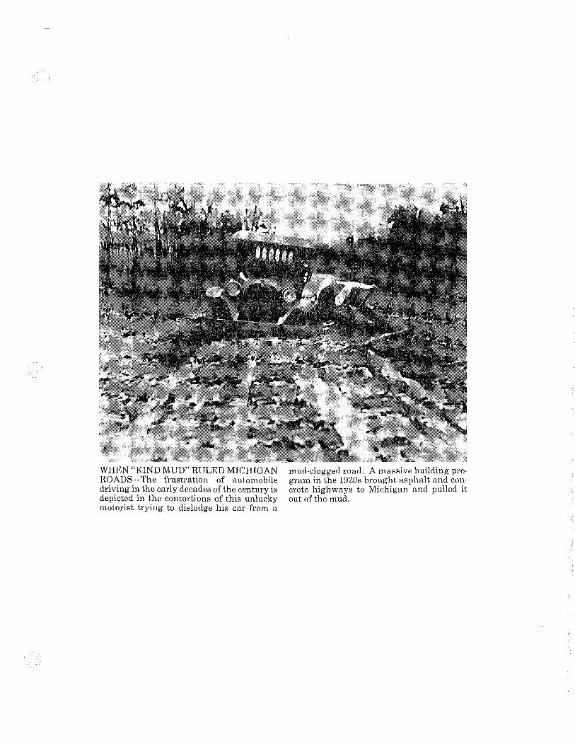
WHEN "KIND MUD" RULED MICHIGAN ROADS--The frustration of automobile driving in the early decades of the century is depicted in the contortions of this unlucky motorist trying to dislodge his car from a
mud-clogged road. A massive building program in the 1920s brought asphalt and concrete highways to Michigan and pulled it out of the mud.

UAI,LAND CO. ';
THE LEGAL ADVERTJSIER ' \
~UG-~7~-~t~l==~---------------------------------------------
[R_Af.!lfQRTAT/0~ IN M~HIGAN HISTORY-
Whihl 'King Mud' Ruled Roads
,._,.:·;~.-- . -~~~~-
and more brickMsurfaced roads disappeared, usually under. some form of asphalt covering·. Some brick surfaces still surM Vive in many cities and towns.
atJildWarcl J; Bouch•r .~,· ~;, as a territory f>elora'c1
1837, Michigan had a governor - never a king.
YET, REFEREtkES to a ruling monarch of sam appear in writings of early state officials, notably Horatio· ·s. Earle, the lint stole hiiJ~way ·• commissioner,· w-ho· daclarecf~
Testifying to the necessity of roads for survival in a new land, Nineteenth Century Michigan law required all male inhabitants over 21 to perform work; or pay for work, on roads in their respec.; · tive areas. The only exceptions stated in the law were ''disabled veterans, paupers, idiots
For the first time in state Bricks, however, normally history, horse~drawn and were used only in cities and pedestrian traffic .was fre~ to towns, not on long -stretches of
trave.l<:.~ul';ing,. sp. ring li·. ·.· ~;-.· -.. , .r'§c~«d'~-~Y between cities. - WA\'IR · · · 'Today, all of Michigan's
war on monarch·· mud; who rules . io the · exd.t~sion of
Why such cl something so.simple•ctc.mud9 .
To a large degree, the histQry of. early,'tOcl,dbuiklli\g'. in ~higdn is'O!'~ of•Q~j figfi\i' ag~~~itlf!i
! roads tutll'ta mud •. · nat!Vng · moves, ROt:- . even· hOt~ or pedestrians, rfluch le.ss· tnotOr · vehicles. ' ·
With the exception of the western Upper lfenin;ula and a few other hilty areas, the first settlers found Michigan terrain ·' · flat to· gently rolling - good:· news for roadbuilders, travelers and transportation.
THI BAD NEWS WAS that Michigan, now nicknamed the HWatet Wonderland," had 36,000 miles of streams and rivers to be bridged or forged, 11 ,OOO"'<Ik~ to be' avoided and on estimQted 11 · million acres of wetlands to be circumvented. Another impediment waa thehea•y day loam soil that turrit t~ mud every spring, and every time it rains.
ancUunatkLn ____ . ::, Despite what was thQn an··
all-out efloit to construct and maihtairi wqg.on roads., every · spring.- andwhen it rained -11
King Mud'1 over the roads, and
back with ·hay and · roads. fh<""ti~st
by rail
fought.
although - victory over mud coil!e irf. 1837 when the Michigan legislature granted a chc!trler to o p'riVate rOod campo~ to construCt a plclnk toll road between Ann ATbor, Plymoutlt and·Oetroit. In 1848, thelegislature pass· ed a general plank road law, authorizing any company to build and operate plank toll roads. lumber then was plentiful in Michigan.
The so·called plank road craze was on, with a total of 202 companies receiving charters for operation._ EvenM tually, 1, 179 miles of plank road were constructed and operated in Michigan.
mud~ began to de;;,otih 9,~00·mile syst~m of plonks olmost os so?n as ,!ll•y · hlgflways and freeways is
wer~· ·;,.laid ...... A··l·d"'*. ~~ .. · . t: ·'p ... d with either concrete or Michig4!>'s ~~i~t\4 ' . ,,>1 asP.,alt os are neorly all of the splashedupfniiiitt\eroadb .-4 18,000 miles of city streets. preYonting plunks from dryin9. ·ONLY 39,000 MILES of Under such conditillns, plail~t ffllf!·'89,000.mile system of had to be replocad'every thr....,,. county roads are paved, leav-years. The cosi of moint!]fning irlg'a 50,000!mireplayground plonf<··raads put mon)> private lor l<ing Mud1 These•riiad• are rood tompanieS:into bonktilpf. . lRIIoJry surfai:eif wi'lfi 'mixtures r::y. By 1900, virtuallfallplankc of clay, gravel, sand or stone roads hod disoppeareik ' · wfth improved drainage, mak.
King Mud was batiW'.i::'>o·.• ifig1r<tvel possible most of the By then, howeve~,>"~1; yem<•·c_ give or talie'a1ittle
builden were expenme_ntll\ii! mud:or dust, · with brick, asphalt, stone-,: F.oT-.-most Michigan motod_~," wooden blocks and combino;; and,-- transporters, ttl. ~-atllftions of cloy, gravel ond·sand: with King Mud has been.won. Bricks- we_re introdvced.,in,_the-, The wor'l- however, still goes 1870s ·a~d osphQJt :rJi :. a.j• ott. Every spring, mud briefly 1880s. Builders gave more· at.:r rises.fr&m beneath pavements tention to the road base and to to create potholes'-tO pe_ster draining water from roods motorists. On the __ unpaved before it could be churned to roadS~ rOud sometimes makes
mud. a comp late comeback, a!. CLAY FOR BRICKS was though usually ,only lor· brief
plentiful in Michigpn-- and periods. throughout the Midwest. Bricks. were easy to re-place and stood up well under traffic. It was easy to repair a brick road surface.
Brick surfaces, however, were rough and slippery when wet or covered with snow or frost. They played havoc with steel-rimmed wagon wheels and early motor trucks and cars with hard rubber'tires. As vehicle speeds increased, more
There, motorists still get stuck and spin their wheels - and curse mud - just as their forebears did years ago.
••• Edward J. Boucher is a
freelance writer fqrmerly associated with the Michigan Department of Transportation and. Secr.etar.y_, ot State.
(Photo on next page)


.• . . ·.
TRANSPORTATION IN MICHIGAN HISTORY
{following is another in a series of articles on interesting aspects of transportation in Michigan history. They are being distributed every few weeks as part of the Sesquicentennial celebratidn marking Michigan's 150th year of statehood.) #5
TRANSPORTATION IN MICHIGAN HISTORY
MICHIGAN--A STATE OF HIGHWAY 11 FIRSTS 1'
By Tom ~hawver
Concrete roadways coursing through woods and farmlands are a
taken-for-granted fact of life in a nation with the best highway
system in th~ world.
So are the white center lines that separate opposing lanes
of traffic and the. painted yellow lines that mark no-passing
zones.
Four-way, three-color traffic lights are commonplace at busy
intersections.
What they have in common is that all were conceived in
Michigan, transportation 11 firsts 11 in the early decades of the
20th Century when the automobile came to the fore as the
predominant mode of travel.
The Wayne County Road Commission built the world's first
mile of rural concrete highway in 1909. It was completed .in less
than three months along Woodward Avenue between Six Mile and
Seven Mile roads at a cost of $13,537.
Engineers and roadbuilders from far and near came to see how
concrete stood up under the traffic of that period. The ·,.
experiment was a success, speeding the development of modern
-2-
highways in Michigan and throughout the country.
Edward N. Hines, the far-seeing chairman of the road
commission, _came up witB another innovation that has been called
the most important traffic safety device in th~ history of auto
transportation. He called it the "center line safety stripe" and
it was simply a stripe of white paint down the middle of the road
to keep traffic on the right side where it belonged.
The center 'stripe first appeared on narrow bridges along
River Road near Trenton, Mich., in 1911 and then on all pavements
in the county. Later it was adopted nationally.
Fred W. Green, who was governor of Michigan from 1927
through 1930, first suggested -~ainting a yellow line on hard
surface highways with hills and curves having restricted si~ht
distances. The State Highway Department tried ou;:. "Green's
yellow line" in 1928 and liked it. So did motorists, who found
it took the "guess and go" out of driving. Like the '<'7hite center
line, the idea caught on.nationally.
The world's first four-way traffic signal with red, green
and amber lights appeared in 1920 at the intersection of Woodward
Avenue and Fort Street in downtown Detroit. It was the
invention of William L. Potts of the Detroit Police Department.
Later, he devised an electrical interconnection of the
signals of 15 traffic towers so that they could be controlled by
a police officer from a single location. The network was the
forerunner of today's sophisticated electronic traffic cbntrol
systems.
-3-
Appropriate to the auto-making capital of the world,
Michigan scored many other highway firsts. Among them:
1912--William B. Bachman Sr., of Detroit, a founder of the
Automobile Club of Michigan, began marking roadside telephone
poles in different colors to designate different routes. By 1920
he had banded 2;000 miles of Michigan highway poles. His work
was the forerunner of a national system of uniform signing of
highway systems.
1919--Herbert F. Larson, engineer-manager of the Iron County
Road Commission, set up picnic tables in a forest preserve along
US-2 in the Upper Peninsula. A state historical marker there
cites it as the na~ion's first such roadside rest and recreation
facility.
1922--The first practical,high~ay snow plow developed in the
United States was designed and built by Edward C. Levy, city
public works superintendent in Munising. It was ~ounted on
runners and consisted of two wooden wings, each 10 feet high and
20 feet long. The wings were retractable, permitting th~ plowing
of a city street, county road or alleyway. Several Upper
Peninsula-cities bought the plows, but they became obsolete a few
years later with the advent of rotary, angle and V-plows mounted
on the front of trucks.
:923-1927--The nation's first intercity superhighway was an
eight-lane divided marvel, built on an 18-mile stretch of
Woodward Avenue between Detroit and Pontiac.
median for public transit service.
It had a 40-foot
-4-
1929--Using planks salvaged from old guardrail, Ionia Cbunty
engineer Allan Williams built picnic tables and set them up along
old US-16 in Ionia County. Soon they became a symbol of Michigan
hospitality along the encir~ highway system, and other states
followed suit.
1935--The nation's first permanent highway travel
information center, built along old US-12 near New Buffalo, at
the Indiana border, was the brainchild of State Highway
Commissioner and later Gov. Murray D. Van Wagoner. The state's
11 such centers now host more than two million visitors a year,
promoting Michigan's multi-billion dollar tourist industry.
1952--The · first five-lane highway was es~ablished in
Detroit, allowing a center lane for left ~urns: It frees the
other four lanes for through traffic and cuts down on rear-end
collisions.
### .
(Tom Shawver is public information administrator for the Michigan De~artment of Transportation.)
Contact: Public Information Transportation, P.O. Box 30050, 517/373-2160)
Office, Lansing,
Michigan Department of Mi 48909. (Phone:
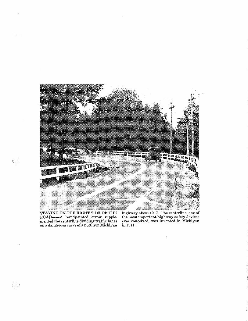
STAYING ON THE RIGHT SIDE OF THE ROAD--A handpainted arrow supplemented the centerline dividing traffic lanes on a dangerous curve of a northern Michigan
highway about 1917. The centerline, one of the most important highway safety devices ever conceived, was invented in Michigan in 1911.

EXPONENT W-7,650
JUN< 3-E 7
Transportation in Michigan Histo~y
A state of highway _ifirsts' By Tom Shawver
Mlcnlgan clopat.tment of Trans~lon
Concrete roadways coursing through woods and farmlands are a taken-fori)ranted fact of life in a nation with the best highway system in the world.
So are the white center lines that separate opposing lanes of traffic and the painted yellow lines that mark no-passing zones.
Four-way, three-color traffic lights are commonplape at busy intersections.
What they have in common is that all were conceived.' in Michigan, transportation "firsts" in the early decades of the 20th Century when the automobile came to the fore as the predominant mode of travel.
The Wayne county road commission built the world's first •. mile of rural concrete highway in 1909. _It was completed in less than three months along Woodwar(i Ave. between Six Mile and Seven Mile roads-at a cost of $13,537.
Engineers and roadbuilders from far -and near came to see how concrete stood up under the traffic of that period. The experiment was a success,. speeding the development of modern highways in Michigan and throughout the country.
Edward Hines, the far-seeing chairman of the road commission, came up with another innovation that has been called the most important traffic safety device in the history of auto transportation. He called it the "center. line saf~l¥,.Strip_e" and it was simply <i"!ftYipe of'' white paint down the middle of the road to keep traffic on the right side where it belonged.
The center stripe first appeared on narrow bridges along River Rd. near Trenton in 1 911 and then on all pavements in the county. Later it was adopted nationally.
Fred Green, who was governor of Michigan from 1927 through 1930, first suggested painting a yellow line on hardsurface highways with hills and curves having restricted sight distances. The state highwaydepartment tried out "Green's;.. yellow line" in 1928 and liked it· So did motorists, who found it ~ took the "guess and go" out of driving. Like the White center -linE!, the idea caught on natio""ally.
The world's first four-way traffic signal with• 1"8\t•.·:~· ·. and amber lights appeare«i 1920 at the intersectfoit ·- -_ .• Woodward Ave. and Fort St tw~ downtown Detroit. It WU.clhe,-""'" vention of William ~r• Wth!J": Detroit police ~ttrit(!;' '''' ·.
later, he deviselj an_~ Interconnection Of· th4r sJgn-~ of. 15 traffic towers so thaf tl\e1'' could be controlled by a polk:.,; officer from a single location. The network was the fore· runner of today's sophisticated electrot~ic traffic controt systems.
Appropriate tp the auto-making capital of the world, Michi· gan scored many other high· way firsts. Among them:
1912-William Bachman Sr. of Detroit, a founder of the Automobile Club of Michigan, began marking roadside telephone poles in different colors to designate different routes. By 1920 he had banded 2,000 miles of Michigan -~hw~:~r poles. His work was the forerunner of a national system of uniform signing of highway systems.
1919-Herbert Larson, engineer-manager of the Iron county road commission, set up picnic tables in a forest preserve along US-2 in the upper peninsula. A state historical marker there cites it as the nation's first such roadside rest and recreation facility.
1922-The first practical highway snow plow developed in the United- States- was designed and built by Edward Levy, city public works superintendent in Munis_ing_ ,It was. mounted on runners· and consisted of two wooden wings, each 10 feet high and 20 feet long. The wings were re· tractable, permitting the plowing of a city street, county road or alleyway. Several upper peninsula..cities bought the plows, but they became obso· late a few years later with the advent. of rotary, angle and V'.' plew$Jn~ted on the front of tr:uckill~ . .,,:;
1S:!af1-g27-The nation's first irJ«!fc:ity ~;Uperhighway was .an. eight,lane divided maiVeT, built 911 an tS:mile stretch of WoodWard Me: betweeh De· trait am:f'P'Oiitiii'c. It hac a 40-foot median tor public transit s_erv~~d . . . '- . . · ·
~s~~~~=: ~~~~~ county engineer Allan \\filliams built picnic tables and set them up alqng old US-1 &· in lonTa countY. Soon they .bec~ame a symbol of Michigan hospitality along the' entire- highway system, and other states
1935-The- nation's first permanent highway travel information center, built along old US·12 near New Buffalo, at the Indiana botder, was the brainchild of State Highway Commissioner and late Gov. Murray Van Wagoner. The state's 11 such centers now host more than two million visitors a year, promoting Michigan's multi-billion dollar tourist industry.
1952-The first five-lane highway was established in Detroit, allowir1g a center lane for left turns. It frees the other four lanes for through traffic and cuts down on rear-end coiI!Stcms:--'
(Photo on next page)

. ;:;.·
A handpainted arrow supplemented the centerline_ d1vidlng traffic lanes on a dangerous curve of a northern Michigan highway about 1917. The centerllne, one of the most important highway safety devTCes ever cQncelved, was Invented in Michigan In 1911. I ~--

TRANSPORTATION IN MICHIGAN HISTORY
(Following-is another in a series of articles on interesting aspects of transportation in Michigan history. They are being distributed every few weeks as part of the Sesquicentennial celebration commemorating Michigan's 150th year of statehood.)#lO
TRANSPORTATION IN MICHIGAN HISTORY
IRON TRUSS BRIDGES ARE A DISAPPEARING BREED
By Edward J. Boucher
There were the Whipples, Howes, the Pratts, the bowstrings
and the highs and the lows.
They were the picturesque wrought-iron truss bridges of the
last half of the 19th Century and the early years of the 20th.
Some, like the Pratts, Whipples and Howes, bore names of
their inventors. Others, like the lows, highs and bowstrings,
were names for appearances.
They carried Michigan wagon roads over rivers and streams --
an indispensable role in a state boasting more then 36,000 miles
of such streams and rivers.
In addition to wagon and foot traffic, they also served as
fishing sites and local attractions, providing pleasant, life-
long memories for many who grew up nearby. Many a child, using
toy "erector" sets, has spent long hours fashioning truss-type
bridges of miniature metal parts similar to those used in the
real thing.
Once numbered in the thousands, general deterioration,
obsolescence and accidents have reduced the number of truss
(MORE)
2
bridges in Michigan to about 400. Most are on lesser-traveled
roads and streets, and each passing year eliminates more.
The oldest, a 150-foot-long truss carrying Maple Road over
the Huron River at Ann Arbor, was constructed in 1876.
Early Michigan settlers built bridges with the most
available material -- wood. Because of inherent weight and load
bearing qualities, however, timber could generally be used only
in short span. Even when bridges were covered, wood did not
stand up well in Michigan's generally wet climate.
Wrought iron truss bridges, made of slim, light beams and
rods, could be built in a factory, dismantled, shipped by rail
and then transported in small sections by wagon to the bridge
site. Wrought iron outlasted wood.
The only serious threat to the truss structures were the
old, massive steam traction engines. These were relatively few
in number, however, and so obviously heavy that operators -
confronted with strict legislation -- pretty much kept them off
old trusses.
Although the truss bridge played a vital role in bringing
Michigan highway transportation into the 20th Century, it was the
new century, with its heavier and faster motorized vehicles, that
ended the popularity of that particular design.
In 1865, a rudimentary steam car, now on exhibit in the
Henry Ford Museum in Dearborn, made a brief appearance on
Michigan roads. Although it caused scant notice at the time, it
(MORE)
3
was the harbinger of times to come. The countdown was on for
truss bridges on highways.
Motorized vehicles began to appear in the 1890s and by 1905,
the first year of vehicle registration, a total of 2,188 were
recorded by the state. By 1920 -- 15 years later -- a total of
416,420 were registered. Today, there are more than seven
million.
An inherent weakness of the truss, at least for modern
transportation, is that all the weight is carried on beams or
posts on both ends of the bridge within a few feet of passing
vehicles. A wagon hitting the beams did no damage, but impacts
from faster, heavier cars and trucks toppled many trusses into
the river below.
In addition, many old trusses could only accommodate one
lane of wagon traffic and could not be widened. To accommodate
two lanes of motorized vehicles, they had to be demolished and
replaced, usually by the simpler "cantilever" design, which has
no superstructure and can be widened.
State, county and city engineers tried to defend the trusses
with weight and speed limits. Due to the largely unknown nature
of the iron in older trusses, however, accurate analysis of the
capacity of many bridges was impossible, Overloads continued to
be a major cause of truss bridge failure.
Today, the Michigan Department of Transportation maintains a
list of all bridges in the state, including old trusses, to help
(MORE)

4
procure funds for replacement and repair. In addition, the
department maintains a list of bridges that are either eligible
for addition to the National Historical Register for actual
preservation or for maintaining a historical record of the bridge
after demolition.
The news for truss bridge buffs is not all bad. On several
occasions in recent years, local admirers have successfully
preserved them for future generations to enjoy.
The city of Allegan in 1983 came up with $215,000 to match
a federal grant of $419,000 for the reconstruction of a one-lane
truss bridge that carries a local street over the Kalamazoo
River. Local interests in Frankenmuth took over and preserved
two truss bridges scheduled demolition.
(Edward J. Boucher is a freelance writer formerly associated with the Michigan Department of Transportation and the Secretary of State.)
(Editor: You may obtain a list of all the Michigan, with location and year built, by Information at P.O. Box 30050, Lansing, MI
truss bridges in writing to MDOT Public
48909.)
TRANSPORTATION IN MICHIGAN HISTORY
(Following is another in a series of articles on interesting aspects of transportation in Michigan history. They are being distributed every few weeks as part of the Sesquicentennial celebration marking Michigan's 150th year of statehood.) #6
.TRANSPORTATION IN MICHIGAN HISTORY
BICYCLISTS LED THE WAY TO GOOD HIGHWAYS
By Edward J. Boucher
Driving on any crowded highway or freeway today makes it
hard to believe that bicycles once ruled the road in Michigan.
And it takes more imagination to believe that the bicycle--
not the motor car -- led Michigan out of the mud onto the paved
roads of the 20th Century.
For a brief period of time from the 1880s to shortly after
the turn of the century, anyone who could afford a "wheel" was
king of the road.
The first bicycles, known as "wheels," were simply a big
wheel with pedals coupled to a small wheel. Not for everyone,
they were hard to mount and harder to ride. Most of the weight
was directly over the big front wheel, causing riders to be
thrown over the handlebars on rough roads or going downhill.
The bicycle, invented by a game warden in Germany in 1816,
soon spread to America and by 1868 enjoyed growing popularity,
particularly among younger and more athletic groups.
The original bicycle, with two wheels of equal size,
resembled modern bicycles more that the subsequent bicycles
produced in the 1860s and 1870s. In 1885, an Englishman named J.
K. Starley invented the so called "safety bicycle" with two equal
-2-
wheels that was easier and safer to ride. This set the stage for
the bicycle craze that hit the United States during the "gay
nineties".
Today, most bicycles look alike, but toward the end of the
19th Century, every manufacturer, inventor and bicycle mechanic
tried to outdo each other designing and producing a better
bicycle.
There were bicycles with big wheels in front and in back,
bicycles with two wheels in front and one in back, bicycles with
four wheels, tandem bicycles, bicycles with seats between the
wheels and bicycles with steam and gasoline motors.
The military developed bicycle divisions with folding
bicycles, bicycles to carry machine guns and fast bicycles to
carry messages. Telegraph companies, with miles of line to
patrol, used bicycles fitted with maintenance gear. Circus
performers used special bicycles for high-wire acts and trick
riding and thieves and pickpockets used them for fast get-aways
on crowded streets.
A new industry sprang up to provide bicycle assessories,
including carbide lamps, clothing and medical treatment for
bumps, bruises, broken limbs and sore muscles. Around 1888,
women began to ride, ushering in new concepts in dress.
Manufacturing techniques, including production lines, electric
welding, improved metals and wider use and demand for road maps
prepared the way for development of the automobile.
For the first time in the history of the human race,a the
bicycle offered mobility for recreation and work to those whose
-3-
previous range of travel was bounded by trolley and railroad
lines, the cost of maintaining a horse and buggy, or by aching
feet.
But beyond the bone-jarring brick and cobblestone paving of
city streets of the time, touring bicyclists faced mud, sand,
loose gravel, angry farmers and, more often, no roads at all.
To improve roads, Michigan bicyclists organized into the
League of American Wheelmen (LAW). Under direction of president
Horatio s. Earle of Detroit, the militant LAW began a campaign to
promote ·and organize roadbuilding bees and prod local governments
into improving existing roads. Before 1905, roadbuilding
responsibilities were shared by townships, cities, counties and,
sometimes, private organizations.
Earle lost no time campaigning for a law to establish a
state highway department to coordinate a statewide system of
highways.
In 1901, he and the LAW founded the Michigan Good Roads
Federation and he became known as "Good Roads" Earle. After
passage of LAW-supported legislation to establish the state
highway department, he became the first state highway
commissioner. His first act was to declare war on what he called
"King Mud," the ruler of the unpaved roads of the era.
This intensive campaign early in the century convinced
voters to support good roads in Michigan and led directly to
Michigan's present all-weather, paved system of highways
ahead of most other states.
well
What happened to the bicycle? During the 1890s, the first

-4-
"horseless carriages" began to appear on Michigan roads. At
first conside~ed a toy, within a few years it replaced the
bicycle as a means of transportation and recreation.
Present day estimates show three to four million bicycles in
Michigan, or approximately half of the number of registered motor
vehicles. But the only state highway still ruled by the bicycle
-- and shared with horses -- is M-185 circling scenic Mackinac
Island, where motor vehicles are banned.·
(Edward J. Boucher is a free-lance writer formerly associated with the Michigan Department of Transportation and Secretary of State.)
Contact: Public Information Office, Michigan Department of. Transportation, P.O. Box 30050, Lansing, MI 48909. (Phone: 517/373-2160)
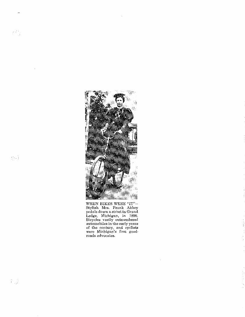
WHEN BIKES WERE "IT"-Stylish Mrs. Frank Abbey pedals down a st1;eet in Grand Ledge, Michigan, in 1896. Bicycles vastly outnumbered automobiles in the early years of the century, and cyclists were Michigan's first goodroads advocates.

IONIA, Ml
SENTINEL-STANDARD
E-4.770
SEP-21-E?
Bicyles once ruled ~?-
Michigan's roads By EDWARD J. BOUCHER Special Writer for MOOT
LANSING - Driving on any crowded highway or freeway today makes it hard to believe that bicycles once ruled the road in Michigan.
And it takes more imagination to believe that tbe bicyde - not the motor car - led Michigan out of !he mud onto the paved roads of the 20th Century.
For a brief period of time from the 1880's to shortly after the turn of the · century, anyone who could afford a "wheel" was king of the road.
The first bicycles, known as "wheels/' were simply a big wheel with pedals coupled to a small wheel. Not for everyone, they were hard to mount and harder to ride. Most of the weight was directly over the big front wheel, causing riders to be thrown over the hai.ullebars on rough roads or going do\ll~ill.
THE BICYCLE, invented by a game warden in Germany in 1816, soon spread to America and by 1868 enjoyed growing popularity, particularly among younger and more athletic groups.
The original bicycle, with two wheels of equal size, resembled modern bicycles more than the subsequent bicycles produced in the 1880's and 1870's. In 1885, an Englishman named J. K. Starley invented the so-called "safety bicycle" with two equal wheels that was easier and safer to ride. This set the stage for the bicycle craze that hit the United States during the "gay -nineties.''
Today, most bicycles look alike, but toward the end of the 19th Century, every manufacturer, inventor and bicycle mechanic tried to outdo each other designing and producing a better bicycle.
THERE WERE bicycles with big wheels in frent and in baek, bicycl .. with four wheels, tandem bicycles, bicycles with seats between the. wheels and bicycles with steam anct gasoline motors. ,
. T_h~ military developeq. · . · bicy.· C(le] dlVISlODS With folding bieyeJeil!f: bicycles to carry maclrinec....,.. antli' fast bicycles to carry messages. Telegraph comparues, with miles of line to patrol, used bicycleo! fitted with maintenance gear. Circus performers used special bicycles for high-wire acts and trick riding and thieves and pickpockets used them for fast get-aways on crowded streets.
A new industry sprang up to provide bicycle assessories, including carbide lamps, clothing and medical treatment for bumps, bruises, broken limbs and sore muscles. Around 1888, women began to ride, ushering in new concept& in dress. Manufacturing techniques, including production lines, electric welding, improved metals and wider use and demand for road maps prepared the way for development of the automobile.
FOR THE first time in the history of the human race, the bicycle of· fered mobility for recreation and work to those whose previous range of travel was bounded by trolley and railroad lines, the cost of main~ taining a horse and buggy, or by aching feet.
But beyond the bone-jarring brick and cobblestone paving of city seets of the time, touring bicyclists faced mud, sand, loose gravel, angry farmers and, more often, no roads at all.
To improve roads, Michigan bicyclists organized into the League of American Wheelmen CLAW). Under direction of president Horatio S. Earle of Detroit, the militant LAW began a campaign to promote and organize roadbuilding bees and prod. local governments into improving existing roads. Before 1905, road· building , responsibilities were shared by townships, cities, counties and, s.oll(etimes, private organizations.
EARLE LOST no time campaigning for a law to establish a .. state highway department to coordlqa\j! a sta_tewide system of highways.
In 1901, he and the LAW founded the Michigan Good Roads Federation andhe lieCame known as "Good Roads" Earle. After passage of LAW-supported legislation to establish the state highway department, he became the first state highway commissioner. His first act was to declare war on what he called llKing Mud," the ruler of the unpaved roads of the era.
This intensive campaign early in the century convinced voters to support good roads in Michigan and. led directly to Mic~igan's present all-weather, p11ve Jystem of highways-well ahea most other states.
WHAT HAPPENED to. the bicycle? During the 1890's, the first "horseless carriages." began to appear on Michigan roads. At first considered a toy, within a few yeers it replaced the bicycle as a means of transportation and recreation.
Present day estimates show three to four million bicycles in Michigan, or approximately half of the number of registered motor vehicles. But the only state highway still ruled by the bicycle- and shared with horsesis M ~ 185, circling scenic Mackinac Island, where motor vehicles are banned.'
(Photo on next page)
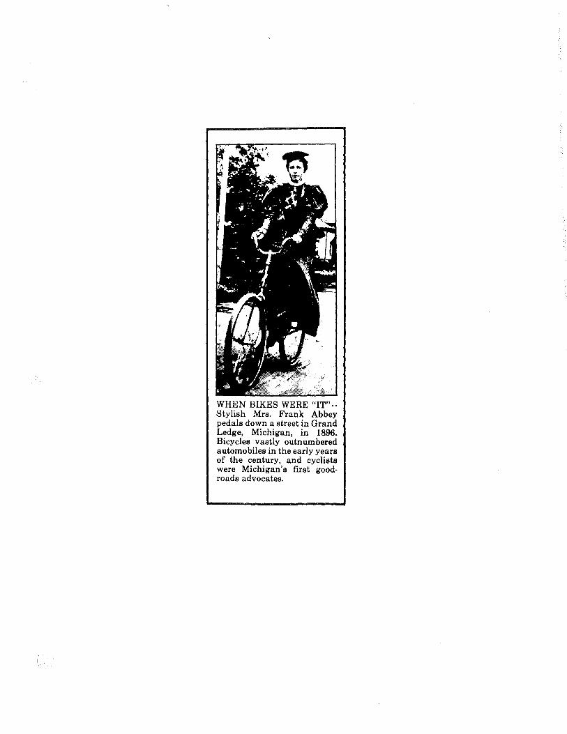
WHEN BIKES WERE "IT"-· Stylish Mrs. Frank Abbey pedals down a street in Grand Ledge, Michigan, in 1896. Bicycles vastly outnumbered automobiles in the early years of the century, and cyclists were Michigan's first good· roads advocates.

TRANSPORTATION IN MICHIGAN HISTORY
(Following is another in a series of articles on interesting aspects of transportation in Michigan history. They are being distributed every few weeks as part of the Sesquicentennial celebration commemorating Michigan's 150th year of statehood.) #7
TRANSPORTATION IN MICHIGAN HISTORY
OLD CHICAGO ROAD, NOW I-94, IS STILL MICHIGAN MAIN STREET
By Edward J. Boucher
Interstate 94, carrying traffic between Port Huron, Detroit
and Chicago, is Michigan's first, busiest, and, by any measure,
most famous freeway.
It runs through the highway corridor that helped develop
Michigan territory into a state in 1837, played a national role
in developing the American Midwest and took on an international
role in World War II.
The final link of I-94 was opened Nov. 29, 1971, in a
snowstorm at the state line near New Buffalo. It provided a
''free way''--free from crossroads, traffic lights, mud, swamps,
fallen trees and s~qrms of mosquitoes--between Port Huron,
Detroit, Chicago and points west to the I-94 terminus in
Billings, Mont.
The opening, in a sense, brought to a conclusion a project
begun by the U.S. Congress in 1824 with appropriation of $3,000
for surveying a military wagon road between Detroit and Chicago.
Prior to 1824, Indians and early settlers followed either
the Great Sauk Indian Trail along present US-12 through the
southern tier of Michigan counties or the St. Joseph Trail
through the second tier, now the route of I-94.

-2-
Michigan's Detroit-Chicago route, together with Lake Erie,
Lake Ontario, the St. Lawrence River and, later, the Erie Canal
between Albany and Buffalo, formed a route followed by settlers
from the east coast to territories of the new American nation.
Prompting the American Congress to improve the route were
fresh memories of the War of 1812 when the British made quick and
frequent raids into both states and territories, which were
difficult to defend because of poor roads.
By 1830, two stage coaches a week carried passengers, mail
and goods between Detroit and Chicago. Many famous taverns,
including the Walker Tavern at Cambridge Junction, now operated
as a state museum, helped ease the rigors of early travel across
southern Michigan.
The Chicago Road, also called the Chicago Turnpike, and
still later, the Old Chicago Road, left Detroit on Michigan
Avenue, now US-12. It passed through Ypsilanti, Ann Arbor,
Chelsea, Grass Lake, Jackson, Parma, Albion, Marshall, Battle
Creek, Kalamazoo, Paw Paw, Coloma, Stevensville, Bridgman, Benton
Harbor, St. Joseph and New Buffalo. During the 1920s, that part
of the route along Lake Michigan was known as
Pike. The entire route also was
the West Michigan
known as the
Michigan-Detroit-Chicago, or MDC, on many early road maps.
The southern route, known as the Chicago Trail, parted
company with the Chicago Road at Ypsilanti and followed what is
now US-12 across the southern tier of counties, through Saline,
Jonesville, Coldwater, Quincy, Bronson, White Pigeon, Niles,
Three Oaks and New Buffalo.

-3-
Since 1824, the actual roads, trails and paths followed by
Detroit-Chicago traffic have changed constantly. When official
and systematic numbering of state highways and routes began in
1926, names of cross-state highways became less important and
many have been forgotten. However, many local remnants and
pieces of the Chicago Road and the trail still bear the names
''Chicago'' and ''Detroit," attesting to their past service to
traffic between the two cities.
World War II wrote another chapter in the history of the
Detroit-Chicago Route. The war caught America unprepared, with
the Allied cause suffering many early and serious setbacks.
To reverse the tide, the war had to be carried to the Axis
powers, and that meant bombers--by the thousands.
Safe from enemy attack and near the skilled Detroit labor
pool, the flatlands near Ypsilanti were chosen for construction
of the largest bomber factory on the North American continent.
There the Ford Motor Co. began turning our the famed B-24
Liberator bomber.
To assure a flow of 42,000 workers in and out of the factory
every 24 hours, the Willow Run Expressway, Michigan's first full
freeway, was constructed in a crash program on the same war
priorities as the factory itself.
Underscoring its importance, President Franklin D. Roosevelt
himself inspected the freeway while it was under construction.
It opened to traffic in the fall of 1942, a bare 11 months
after work began.
-4-
When Congress funded the nation's interstate highway program
in 1956, and construction of Interstate 94 began, the original
pavement of the Willow Run Expressway was incorporated into the
freeway.
Barring frequent construction and repairs necessary to
maintain current volumes of traffic, the trip between Chicago and
Detroit today is a matter of hours. And literally hundreds of
thousands of vehicles travel along the route every day of the
year.
###
(Edward J. Boucher is a freelance writer formerly associated with the Michigan Department of Transportation and the Secretary of State.)
Contact: Public Transportation, 517/373-2160)
Information Office, Michigan P.O. Box 30050, Lansing, MI
Department of 48909. (Phone:

OBSERVER Bl-1. EEKL Y-28,717
AUG·! 7-E. 7
1-941 area's history roll along together By Edward J. Boucher special writer
Interstate 94, carrying traffic between Port Huron, Detroit and Chicago, is Michigan's first, busiest and mostfamous freeway,
It runs througb the higbway corridor that helped develop Michigan territory into a state in 1837. It played a national role in developing the American Midwest. And it took on an international role in World War II. -
The final link of I-94 was opened Nov. 29, 1971, in a snowstorm at the state line near New Buffalo. It provided a Hfree way" - free from crossroads, traffic ligbts, mud, swamps, fallen trees and swarms of mosquitoes - from Port Huron tbrougb Detroit and Chicago to its terminus in Billings, Mont.
The opening brougbt to a conclusion a project begun by the U.S. CongrP.SS in 1824 with appropriation of $3,000 for surveying a military wagon road between Detroit and Chica• go.
PRIOR TO 1824, Indians and early settlers followed either· the Great Sauk Indian Trail along present US-12 througb the southern tier of Michigan counties or the St. Joseph Trail througb the second tier, now the route of I-94.
Michigan's Detroit-Chicago route - together with Lake Erie, Lake Ontario, the St. Lawrence River and later the Erie Canal across New York State - formed a route that. settlers followed from the east c?as~ to territories of the new Amer1can nation.
Prompting the American Congress to improve the route were fresh. memories of the War of 1812 when the British made quick and frequent raids into both states and territories, which were difficult to defend because of poor roads.
Bu 1830, two stages coaches a week carried passengers, mail ·and goods between Detroit and Chicago. Many famous taverns, including the Walker Tavern at Cambridge Junction, now operated as a state museum, helped ease the rigors of early traV'el across southern Michigan.
THE CHICAGO ROAD, also called the Chicago Turnpike and later the Old Chicago Road, left Detroit on Michigan Avenue, now US-!2.
It passed througb Ypsilanti, Ann Arbor, Chelsea, Grass Lake, Jack-
son, Parma, Albion, Marshall, Battle Creek, Kalamazoo, Paw Paw, Coloma, Benton Harbor, St. Joseph, Stevensville, Bridgman and New Buffalo.
During the 1920s, that part of the route along Lake Michigan was known as the West Michigan Pike. The entire route also was known as the Michigan-Detroit-Chicago, or MDC, on many early road mapa.
The southern route, known as the Chicago Trail, parted company with the Chicago Road at Ypsilanti and followed what is now US-12 across the southern tier of counties, through Saline, Jonesville, Coldwater, Quincy, Bronson, White Pigeon, Niles, Three Oaks and New Buffalo.
Since 1824, the actual roads, trails and paths followed by Detroit-Chicago traffic have chang"!' constantly.
When official and systematic numbering of state higbways and routes began in 1926, names of cross-state higbways became less important. Many have been forgotten.
However, many local remnants and pieces of the Chicago Road and the trail still bear the names "Chicago" and "Detroit," attesting to their past service to traffic between the two cities.
WORLD WAR II wrote another chapter in the history of the DetroitChicago Route. The war caugbt America unprepared. The Allied cause suffered many early and serious setbacks.
To reverse the tide, the war had to be carried to the Axis powers, and that meant bombers - by the thousands. Safe from enemy attack and near
the skilled Detroit labor pool, the flatlands near Ypsilanti were chosen for. construction of the largest bomber factory on the North American continent. There the Ford Motor Co. began turning out the famed B-24 Liberator bomber.
To assure a flow of 42,000 workers in and out of the factory every 24 hours, the Willow Run Expressway,_ Michigan's first full freeway, was cousiructed in a crash program on the same war priorities as the facto; ry itself.
Underscoring its importance, President Franklin D. Roosevelt himself inspected the freeway while it was under construction.
THE WILLOW RUN Expressway opened to traffic in the fall of 1942, a bare 11 months after work began.
When Congress funded the n.ation's interstate higbway program in 1956, and construction of Interstate 94 began, the original pavement of the Willow Run Expressway was incorporated into the freeway.
Barring frequent construction and repairs necessary to maintain current volumes of traffic, the trip between Chicago and Detroit today is a matter of hours. And literally hundreds of thousands of vehicles travel along the route every day of the year.
Edward J. Boucher is a freelance writer formerly associated with the Michigan Department of Tr~rtatiOn-and the Secretary of State.

TRANSPORTATION IN MICHIGAN HISTORY
(See photo enclosed)
(Following is another in a series of articles on interesting aspects of transportation in Michigan history. They are being distributed every few weeks as part of the Sesquicentennial celebration marking Michigan's 150th year of statehood.) #8
TRANSPORTATION IN MICHIGAN HISTORY
POOR SIGNING MADE IT TOUGH TO GET FROM HERE TO THERE
By Edward J. Boucher
Prior to 1927, Michigan_motorists or motorists in any
other state -- could never be sure of reaching a destination over
unfamiliar roads.
Educated guessing and cross-examining local gentry were part
of every trip. The reason: lack of standardized road signs and
few, if any, accurate highway maps.
What happened in 1927 and why did it take so long for the
nation and the states to coordinate something so seemingly simple
as standard highway signing and numbering and printing accurate
highway maps?
The preamble of the U.S. Constitution mentions promotion of
post roads as a federal responsibility. Road for defense and
moving goods and mail were one of the first concerns of the
emerging American nation.
Immediately after the American Revolution, the federal
government voted funds for construction of "military" roads in
Michigan territory. It wasn't until 1905, however, that the
Michigan Legislature enacted legislation to oversee road building
in the state. Previously, construction, maintenance, signing and
2
mapping of roads was mostly an uncoordinated effort. It involved
townships, counties, cities, villages, public roadbuilding "bees"
and private touring associations, including the Dixie and Lincoln
Highway associations and the bicyclists who formed the League of
American Wheelmen.
The trouble was that the same organizations that helped
construct highways also helped name and number them. The result
was a mass of different and som•times conflicting colors,
numbers, bands and names painted or attached .to roadside rocks,
barns, telephone poles, buildings and posts of all lengths.
Earlier and slower horse-drawn traffic was not seriously
bothered by lack of consistent signing and maps, but by the 1890s
the Wheelmen who rode the newly-invented bicycles farther and
farther from home began to demand better roads and signing.
Appearance of the automobile after the turn of the century
compounded the problem and by the 1920s, the owners of horse
drawn traffic and more .than one million registered motor vehicles
in Michigan had serious problems finding their way over
unfamiliar territory.
Actually, the state got into the
making busines• under Michigan Act 19
highway·signing and map
of Public Acts of 1919.
Among other things, the new law directed the state highway
commissioner to "cause all state trunkline route• to be
distinctly marked by signs and guideposts of a uniform design as
may be deemed necessary for the public convenience and to cause

3
to be published a map of the State of Michigan showing thereon
the state and county road system."
The act also called for numbering state highways and
showing the numbers of the map.
The State Highway Department, now the Department of
Transportation, designed a diamond sign 15 inches in length and
13 1/2 inches wide with the words STATE TRUNK LINE and carrying
an M and a route number. But that only worked in Michigan.
Interstate-travel was another matter.
By 1925, the volume of complaints over confusion in highway
signing reached W~shington and the American Association of State
Highway Officials (AASHO).
AASHO then petitioned the Secretary of Agriculture, who then
supervised public roads in the U.S., to name a joint board t0
develop an_ interstate numbering: and marking system covering the
principal highways of the nation.
One of those serving on the board was Michigan State highway
Commissioner Frank Rogers. His suggestion and rough drawing of a
shield displaying the letter "U.S." and a number was adopted as
the official road marker for all routes throughout the country.
A lot of study, controversy and comprise went into the
board's recommendation to number principal east-west routes
across the nation in multiples of 10 -- even numbers -- and
north-south routes in multiples of five. odd numbers.
States were free to number their own remaining internal
4
routes with their own individual state logo and number, as
Michigan did under Act 19 in 1919.
AASHO was to have control over all future numbering and
changes in interstate highway routes. The entire plan was
voluntary but was adopted by all states and the federal
government in 1925 ..
On the night of May 2, 1927, temporary card markers showing
the new U.S. routes i~ Michigan were placed over existing signs.
The following morning •otorists awoke to a new era of
standardized highway signs with consistent numbers throughout
Michigan and the United States.
The 'system was so well designed that it continues in use
today with only slight modifications.
When the nation's new Interstate system of freeways was
begun in 1956, the original AASHO numbering system, together with
Frank Rogers' shield, was used to designate the entire 42,500-
mile system.
Today, all that's needed to get across the state is an
accurate map and a tank of gas.
'###
(Edward J. Boucher is a freelance writer formerly associated with the Michigan Department of Transportation and the Secretary of State.)
Contact: Public Information Transportation, P.O. Box 30050, 517/373-2160)
Office,. Michigan Department of Lansing, MI 48909. (Phone:
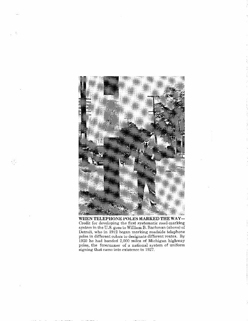
WHEN TELEPHONE POLES MARKED THE WAY-Credit for developing the first systematic road-marking system in the U.S. goes to William B. Bachman (above) of Detroit, who in 1912 began marking roadside telephone poles in different colors to designate different routes. By 1920 he had banded 2,000 miles of Michigan highway poles, the forerunner of a national system of uniform signing that came into existence in 1927.

OIU f\Mf 11...1"'1 ""
PIONEER E-32,577
SEP-21-E?
Michigan roads: Guesswork was a sign of the times ~yEDWARDJ.BOUCHER
Prior to 1927, Michigan motorists - or motorists in any other state - could never be sure of reaching a destination over unfamiliar roads.
Educated guessing and cross-examining local gentry were part of every trip. The reason: lack of stan, dardized. road signs and few, if any, accurate highway maps.
What happened in 1927 and why did it take so long for a nation and the states to coordinate something so seemingly simple as standard highway signing and numbering and printing accurate highway maps?
The preamble of the U.S. Constitution mentions promotion of post roads as a federal responsibility. Road for . defense and moving goods and mail were one of the first concerns of emerging American na> tion.
Immediately after the Americ~ Revolution, the federal government ·voted funds for construction of. "military" roads in Michigan ~i ritory. It wasn't until 1905, hoW"): ever, that the Michigan Legislatltte ··· enacted legislation to oversee road' bqilding in the state, Previously, construction, maintenance, signing and mapping of roads was mostly an uncoordinated effort. It involved townships, counties, villages, pub. lie rll!ldbuilding.':bee&" and privatD. touring assoc~, including the Dixie ·and Li~:- Hi~way a&sociations and ~llicyclists· who formed the LeaaiMt of ~can Wheelmen.
The trobble was that the same organizations that helped construct highways also helped name and number them. The result was a mass of different and sometimes conflicting colors, numbers, bands and names painted or attached to roadside rocks, barns, telephone poles, buildings and posts of all lengths.
Earlier and slower horse-drawn traffic was not seriously bothered by lack of consistent signing and maps, but by the 1890s the Wheelmen who rode the newly-invented bicycles farther and farther from home, began to demand better roads and signing.
Appearance of the automobile after the turn of the century compounded the problem and by the 1920s, the owners of horsedrawn traffic and more than one million registered motor vehicles in Michigan, had serious problems finding their way over unfamiliar territory.
Actually, the state got into the highway signing and map-making business under Michigan Act 19 of Public Acts of 1n9. Among other things, the new law directed the state highway commissioner to "cause all state trunkline routes to be distinctly marked by signs and guideposts of a uniform design as may be deemed necessary for the public. convenience and caused to be published, a map of the State of Michigan showing thereon the state and county road system."
The act also called for numbering state highways and showing the numbers of the map.
The State Hi~Deparunent, now the Department of Transportation,_ designed a diamond sigh 15 inches in length and 13 ~ inches wide with the words "STATE TRUNK LINE" and carrying · the letter "M" and a route number. But · that only worked in Michigan. Interstate travel was another matter.
By 1925, the volume of complaints over confusion in highway signing, reached Washington and the American Association of State Highway Officials (AASHO).
AASHO than petitioned the Secretary of Agriculture, who then supervised public roads in the U.S., to name a joint board to develop an interstate numbering and marking system covering the principal highways of the nation ..
Une ot those servmg on the board was Michigan State highway commissioner Frank Rogers. His suggestion and rough drawing of a shield displaying the letters "U.S." and a number, was adopted as the official road marker for all routes throughout the country.
A lot of study, controversy and comprise went into the board's recommendation to number principal east/west routes across the nation in multiples of 10- even numbersand northj.south routes _in multiples of. five,- odd numbers.'
S.tatiiS were free to number their ovin reinluning internal routes with their own individual state logo and number, as Michigan did under Act 19 in 1919.
AASHO · was to have control over all future numbering and changes in interstate highway routes. The entire plan was voluntary, but was adopted by all states anp the federal government in 1925.
On the night of May 2, 1927, temporary card markers showing the new U.S. routes in Michigan, were placed over existing signs.
The following morning, motorists awoke io a new era of standardized highway signs with consistent numbers throughout Michigan and the United States.
(Photo on next page)
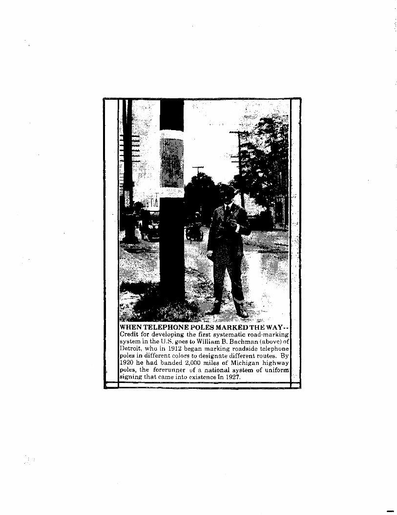
TELEPHONE POLES MARKED THEW A Y -for developing the first systematic road-marking
"'"'"r'""" in the U.S. goes to William B. Bachman (above) of who in 1912 began marking roadside telephone
poles in different colors to designate different routes. By 1920 he had banded 2,000 miles of Michigan highway
les, the forerunner of a national system of uniform that came into existence in 1927.

TRANSPORTATION IN MICHIGAN HISTORY
(Following is another in a series of articles on interesting aspects of transportation in Michigan history. They are being distributed every few weeks as part of the Sesquicentennial celebration commemorating Michigan's 150th year of statehood.) #9
TRANSPORTATION IN MICHIGAN HISTORY
MOTORISTS ONCE FREE-WHEELED WITHOUT LICENSES
By Edward J. Boucher
Your two-color vehicle license plate and plastic-covered
State of Michigan driver license displaying the unflattering "mug
shot" were items unknown to many of our fathers and grandfathers.
State registration of vehicles did not begin until 1905 and
driver licensing was not undertaken by the state until 1919.
Before then, anybody could drive anything anywhere--roads
permitting-~with no license or plates.
Records from the Secretary of State's office show a total of
2,188 motor vehicles were registered in 1905. Las.t year 6. 3
million licensed drivers registered 7.7 million vehicles for use
on the state's 118,000-mile system of highways, roads and
streets.
Before 1905, some cities registered commercially-used horse-
drawn vehicles and simply used the same paper forms to register
motor vehicles.
From 1905 to 1910, a small round metal tag served as a
registration for motorized vehicles. It was usually fastened on
the dashboard, but motorists also were required to display the
number on the rear of the vehicle. This was done by mounting the
number on a larger license plate, usually made of leather and
measuring six by 14 inches.

2
The year 1910 marked the first time metal license plates
were issued in Michigan. These were made of porcelain-covered
steel and displayed three or four white numbers on a black
background with the abbreviation "MICH" and the year.
The porcelain pl~tes were issued until 1915 when the state
began using stamped metal plates that resembled those issued
today. Since then, Michigan plates have run the gamut of colors
from the olive green of 1918 to the light purple of 1936, from
the dull silver of 1961 to the maroon of 1941, 1944, 1957 and
1971. Most popular of all probably was the red, white and blue
plate issued in 1976 to commemorate the nation's bicentennial.
Sixty-eight years ago, on July 1, 1919 Michigan Gov. Albert
Sleeper obtained the first Michigan driver license from Secretary
of State Coleman E. Vaughn. Probably the leading to driver
licensing was the return of the "engine-oriented" doughboys from
World War I service in France. As large numbers of these young
men began driving, the caused concern for the safety of
pedestrians and of non-motorized vehicles. That same year, the
legislature granted the Michigan Secretary of State power to
discipline careless drivers, leading to today's point system for
driving infractions. The photo was added to the driver license
in 1965.
The first driver license was printed on linen-backed paper.
It had no renewal date. Applications were taken by local and
state police or sheriffs, and the licenses were issued by the
Secretary of State.
Today, the majority of Michigan's licensed vehicle operators

3
receive licenses by mail or through the approximately 180 branch
offices operated statewide by the Secretary of State.
When Michigan was organized as a state, the Secretary of
State kept minutes af meeting~, vital statistics and records of
crops and cattle and weather. He also was the custodian of. laws
passed by the legislature. Today the Motor Vehicle Division with
responsibility for vehicl• registration and driver licensing is
the largest operation in that department
###
{Edward J. Boucher is a freelance writer formerly associated with the Michigan Department of Transportation and the Secretary of State.)
Contact: Public Information Transportation, P.O. Box 30050, 517/373-2160)
Office, Michigan Department of Lansing, MI 48909. · {Phone:
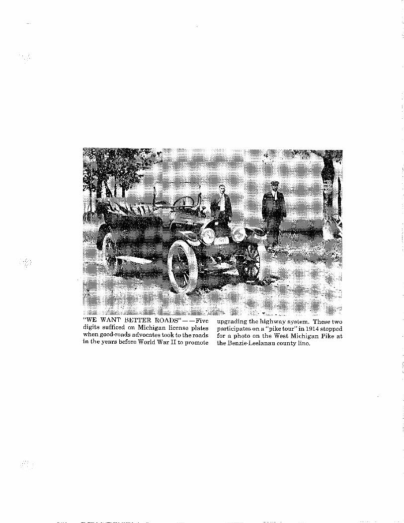
"WE WANT BETTER ROADS"--Five digits sufficed on Michigan license plates when good-roads advocates took to the roads in the years before World War II to promote
upgrading the highway system. These two participates on a "pike tour" in 1914 stopped for a photo on the West Michigan Pike at the Benzie-Leelanau county line.

MARSHALL, Ml
EVENING CHRONICLE E-3, 119
_...-__., )d
OCT-23-5 7
Guest editorial Driver licenses weren't a thing of the past
Your two-<:olor vehicle liee~Ue plate and plasticcovered =of Micbipn Clrivers license displaylnli tliii ttering "mug shot• w'ere items unknown to many of our fathers and grandfathers.
Stata rep.tration of vohiclee did not begin until 1905 and driver's licenaing wae not undertaken by the atate until 1919. Before then, anybody could drive anything anywhere - roads permittingwith no license or pi-
Records from the Secretary of State's office show a total of 2,188 motor vihlclea ·were-regiStered in 1906. Laai year, 6.3 million licensed drivers registared 7.7 million vehicles for use on the state's 118,000 mile system of highways, roads and streets.
Before 1906, oome citiea regiatsred commen:iallywoed horse-drawn vehiclea and simply used the same paper forma to registar motor vehicles.
From 1906 to 1910, a small round metal tag served u a regi'"""tion for motor vehicles. It was uual1y fastened 'on the daahhoard, but motorists aJ.o, -re required. to display the numb8r on the l'1IIIJ' of the ve~ Thia wae done by mowiting the number on a I...., license plats, usually made of leather and meaeurlnai lix by 14 inches.
The year 1910 ... marked the firat time metal license platse were iuued in Michigan. These were made at porcelain-<:OVered steel and displayed three or four white numbera on a black bMkground with the nbbreviation "MICH" and the year. .
The porcalain platse were issued witil1915 when the state began using &tamped metal platsa that reaembled those issued today. Since then, Michigan.· plates have run the gamut of colors ~om the olive gr-. of 1918 to tiM light purple of 136, from the dull .n._ Gif,lN~ to the IIIAilOOil of 1941, 1944, 1957 and 'lt'flr The moa popular of all probably
was the red, whits and blue plats issued in 1976 to commemorate the nation'• bicentennial.
Sixty-eight years ago, on July 1, 1919 Michigan Governor Albert Sleeper obtained the ftrat ev• Miclrigan driver license from Secretary of Stata Coleman E. Vaughn. Probably leading to dri~ licellsing was the return of "engine-<lrientsd" doughboy• from World War I aervice in Fran.,., A. large numbers of these young men began driving, there was concern for the safety of pedeatriana 8lld non-motorized vehicles. That same year, tiM letlialature granted Michigan Secretary of Stata power to discipline careless drivers, leading to ~ point systsm for driving infractiona. The pilabt ._. added to the driver license in 1966.
The first driver license waa printed Oil ubacked paper. It had no renewal date. Applicationa were taken by local and state polii:e or lheriflll, and the licenses were isoued by the Secretary a£ Bt.t~.
'lbday, the majority of Michigan'• vAicle operators receive licenees by mail or _thro111ff'@:. proximately 180 brsneh office operated~ by the Secretary of Stats. ' '· · ,
When Michigan organised ae a ataa, llbll Secretary of Stats kept minutes ef'meetina-r villd statistics and recorda of crops and cattle 'uid weather. He also was the custodian of laws puaed by the legislature. 'lbday the Mator Vehicle Di~
with the responsibility for vehicle registration eAi driver licensing is the largest operation 'iJl.t!Ui$ department.
Edward J, Boucher ia a freelance 'lll'l'ker formerly aseociated with the. MlieJafje• Department of Transportation IIA4 - tiUr &eretarY of State. · -~----~
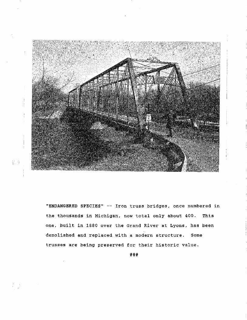
L
"ENDANGERED SPECIES" -- Iron truss bridges, once numbered in
the thousands in Michigan, now total only about 400. This
one, built in 1880 over the Grand River at Lyons, has been
demolished and replaced with a modern structure. Some
trusses are being preserved for their historic value.
###
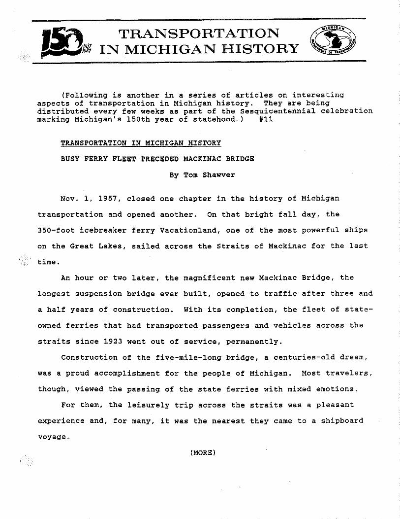
TRANSPORTATION IN MICHIGAN HISTORY
(Following is another in a series of articles on interesting aspects of transportation in Michigan history. They are being distributed every few weeks as part of the Sesquicentennial celebration marking Michigan's 150th year of statehood.) #11
TRANSPORTATION IN MICHIGAN HISTORY
BUSY FERRY FLEET PRECEDED MACKINAC BRIDGE
By Tom Shawver
Nov. 1, 1957, closed one chapter in the history of Michigan
transportation and opened another. On that bright fall day, the
350-foot icebreaker ferry Vacationland, one of the most powerful ships
on the Great Lakes, sailed across the Straits of Mackinac for the last
time.
An hour or two later, the magnificent new Mackinac Bridge, the
longest suspension bridge ever built, opened to traffic after three and
a half years of construction. With its completion, the fleet of state-
owned ferries that had transported passengers and vehicles across the
straits since 1923 went out of service, permanently.
Construction of the five-mile-long bridge, a centuries-old dream,
was a proud accomplishment for the people of Michigan. Most travelers,
though, viewed the passing of the state ferries with mixed emotions.
For them, the leisurely trip across the straits was a pleasant
experience and, for many, it was the nearest they came to a shipboard
voyage.
(MORE)
2
The ferries plied the narrow gap that separates Michigan's two
peninsulas seven days a week, the year around. Service was rarely
suspended because of bad weather, but there were times when strong
winds jammed ice into dock areas, trapping even the big Vacationland,
queen of a five-ferry fleet.
There were other delays when auto traffic got heavy. In the
November deer-hunting season, thousands of hunters jammed the docks
and the adjoining highway while they waited to board the ferries.
Vendors did a lively business selling hot pasties and other items to
impatient drivers and their passengers eager to move on to the Upper
Peninsula.
The state ferries operation came into being through an act of the
State Legislature, which reacted to public displeasure with the
infrequent and expensive ferry service for motor vehicles provided by
railroad ferries. The State Highway Department--now the Michigan
De~artment of Transportation--started the service July 31, 1923, with
the Ariel, a small carferry operating in the Detroit River between
Detroit and Walkerville, Ont. Buying and fitting it to pass marine
inspection cost the state $19,000.
Before ice stopped the service on Nov. 21 that year, the Ariel,
with a capacity of only 20 cars, had hauled 10,351 cars across the
straits. That was many more than the railroad boats, with their
irregular schedules, would have carried.
Recognizing the need for the service, the highway department
bought two more used boats late in 1923, bringing them from the East
{MORE)

3
Coast to Detroit. There they were lengthened so they could carry 40
cars each and rechristened the City of St. Ignace and City of Mackinaw
City. Both went into service the following summer, leading to the sale
of the tiny Ariel.
Ferry traffic at the straits nearly quadrupled in the second year,
with more than 38,000 vehicles making the crossing .. A third boat, the
Straits of Mackinac, joined the fleet in 1928.
Winter service began in 1931, first under an arrangement for a
railroad icebreaker to carry cars across the straits during the cold
·months and then, in 1936, under a lease that put the railroad
icebreaker Sault Marie in service on a regular schedule.
Business at the straits kept growing, and so did the ferry fleet.
In 1937, the highway department bought the City of Cheboygan, a
converted Lake Michigan carferry. Then came two larger rebuilt car
ferries, the City of Munising in 1938 and the City of Petoskey in 1940.
The smaller St. Ignace and Mackinaw City were sold to the federal
government for service on the Atlantic Coast.
The first of the ferries specially designed to carry straits
traffic was the 10,000-horsepower Vacationland. Built for $4,475,000
at the Great Lakes Engineering Works in River Rouge, Mich., it was 350
feet long, with a 75-foot beam. The Vacationland, half again larger
than the largest of the other ferries, carried nearly 150 cars and
trucks. Its arrival raised the fleet capacity to about 500 vehicles.
By the time the five-vessel went out of business in 1957, it was
carrying between 900,000 and one million vehicles a year.
(MORE)

4
All five vessels were sold and put to other uses. The Straits of
Mackinac carried passengers between Mackinaw City and Mackinac Island
until 1968 as part of a fleet owned by a group of former ferry
employees.
Later Peterson Builders, Inc., of Sturgeon Bay, Wis., bought the
ferry and converted it into a floating dormitory of sorts for Navy men
sent for training and shakedown cruises aboard ships built by the
company. Today, it is a mere storage barge.
The City of Munising and City of Cheboygan served as floating
warehouses for Edward H. Anderson, a major potato grower and dealer on
Washington Island off the tip of Wisconsin's Door Peninsula in Lake
Michigan. About 10 years ago, they were towed to Italy after being
sold for scrap.
The City of Petoskey had met the same fate in 1961.
The Vacationland, pride of the fleet, led a somewhat more
glamorous life. After hauling truck trailers between Detroit and
_Cleveland, it was sold to a private company in 1961 and as the Pere
Novel it churned back and forth across the Gulf of St. Lawrence
carrying vehicles and passengers.
The Province of British Columbia bought the vessel in 1967,
renamed it the Sunshine Coast Queen and towed it to the Pacific Coast
for ferry service there. A $600,000 alteration job increased its
capacity to 220 cars. Later, it was bought for service in Alaska, but
reportedly never went into operation.
(MORE)

5
There was talk of bringing the Vacationland back home for duty on
Lake Michigan by a private company, but nothing happened. Later the
ship was said to be headed to a scrapyard in Shanghai but sank in the
Pacific in December 1987 about 100 miles off the coast of Washington.
Meanwhile, traffic at the Mackinac Bridge has climbed to about
three million vehicles a year, more than three times what the fleet of
ferries carried in its best year.
###
(Tom Shawver is public information administrator for the Michigan Department of Transportation.)
Editor:
This is the last of the sesquicentennial series. Copies of any or all of the 10 previous articles may be obtained by writing to the Public Information Office, Michigan Department of Transportation, P.O. Box 30050, Lansing, MI 48909. The titles are as follows:
1. Indians Started Road from Footpaths to Freeways 2. Sled Dogs Carried Supplies, Mail in Early-Day Michigan 3. Plank Roads Were the Rage in 19th Century Michigan 4. "King Mud" Once Ruled the Roads 5. Michigan--A State of Highway "Firsts" 6. Bicyclists Led the Way to Good Highways 7. Old Chicago Road, Now I-94, is Still Michigan Main Street 8. Poor Signing Made it Tough to Get from Here to There 9. Motorists Once Free-Wheeled Without Licenses
10. Iron Truss Bridges are a Disappearing Breed
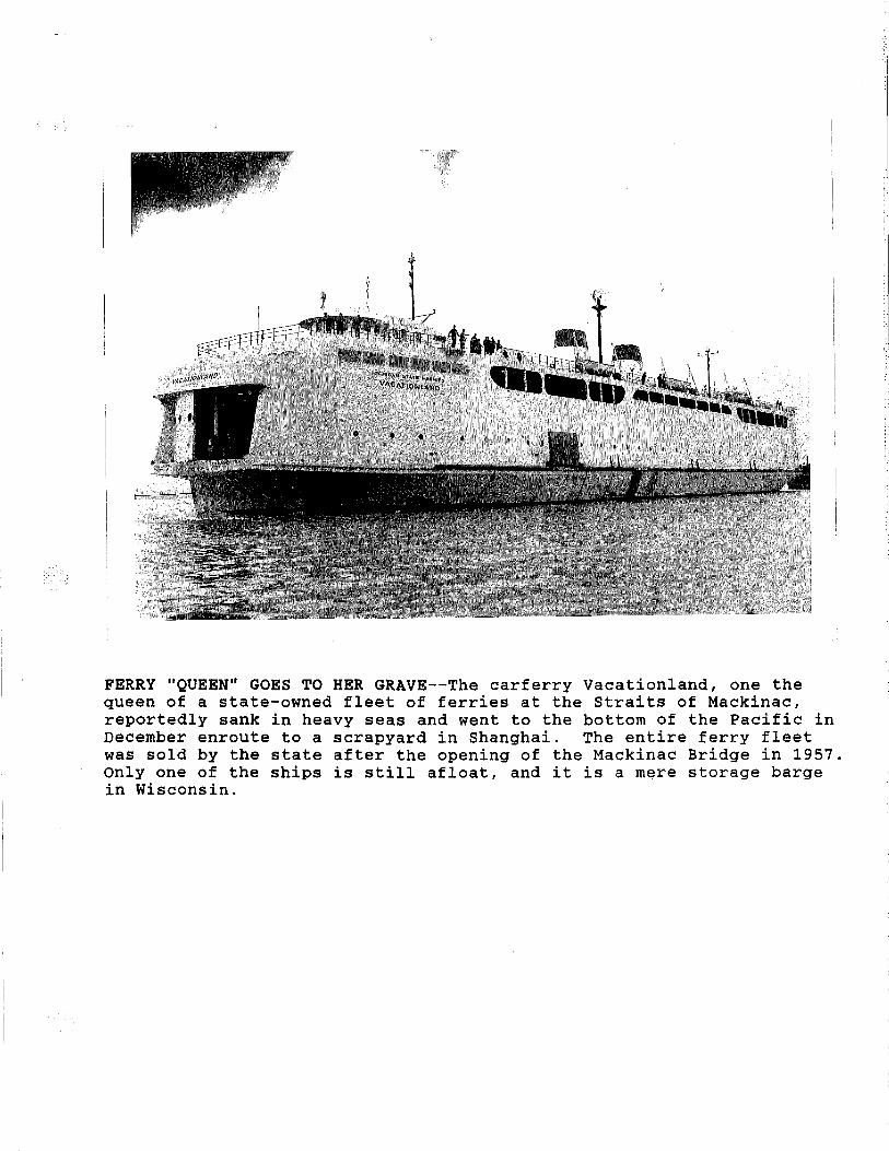
FERRY "QUEEN" GOES TO HER GRAVE--The carferry Vacationland, one the queen of a state-owned fleet of ferries at the Straits of Mackinac, reportedly sank in heavy seas and went to the bottom of the Pacific in December enroute to a scrapyard in Shanghai. The entire ferry fleet was sold by the state after the opening of the Mackinac Bridge in 1957. Only one of the ships is still afloat, and it is a mere storage barge in Wisconsin.

·- A SUMMARY OF THE DEVELOPMENT OF MICHIGAN'S RURAL ROAD SYSTEM
' '
Michigan's rural road development fi~st began with
General Lewis Cass in 1813 who enl~sted the support of Congress·
for road construction; both as.a means of speeding up Mr_c;higan's
settlement and of bolstering military defenses.
Federal troops were used in the construction of the
Detroit-Toledo Road as well as roads from Detroit to Saginaw;
Port Huron, Grand Rapids, and Chicago; however, after Michigan
became a state in 1837, this Federal assistance was withdrawn.
Because the state ~ad little money to spend for road purposes~
the roads previously built soon fell Into a condition of
disrepair. In an attempt to continue the development ofca
~-::__:.::::_=:-_=r~oad netwo!"i{, private_p]ank road companies were formed -anawork-
was begun on the construction of d~signated plank road routes.
but unfortunately, these private toll roads turned out to be
unsuccessful and were discontinued around 1850.
A territorial law in 1827 had established the township - . I
as the basic unit of road administration which was further
perpetuated by the revised State Constitution of 1850, which
caused ·all·roads previously built to be transferred to the
jurisdiction of the townships. This township administration
was basically premised on the fact that_the maintenance,
impro~~ment, and construction of the road system was primarily
the responsibflity of the people who lived along the roads.
This concept g.enerated the "statute labor system", which
required the property owner to work the roads a certain number

,. - z-
of days each year, depending upon the value of his property, or
el.se commute his labor by a cash payment to the township.
Those residents who did not own property along a road were
as s e s s e d one d a y's w o r k a yea r o r an e q u i v a 1 e i1 t t a x • The.
roads built under this system gen~rally connected farms with a
tracling center.
As the demand for more extensive t"rave 1 increased it was
felt that there should be an administrative -u-;;Jt developed that
had a wider tax bas~ than the township. Thus, in 1893 the County
Road Act was passed, which permitted, by a vote of the residents,
any county to appoint or elect a county road commission which
was empowered with the authority to consolidate various township
roads into a county-wide system. Counties which voted to adopt
a county road system were authorized to le-vT-roa-d-taxes up to
three m i 11 s. The adoption of this county road system was -slow
in developing, with the last county" voting.-the"system in, in 1923.
By 1900, nearly $100 million had been spent in-Michigan
to build and maintain a 68,000 mile road system. At this time
only 200 miles were surfaced wi th 1 stone or macadam and l.ess
than 8,000 miles with gravel. The rest were sand ·or clay.
In 1901 a committee, headed by Senator Horatio Earle,
advocated a constitutional amendment to remove the .existing
prohibition against using state funds for road i~provement. In
1905 an amendment was passed authorizing the state to build or
aid iri the building of public wagon roads. At this time the
legislature created a State Highway Department and appointed
Horatio Earle as the first State Highway Commissioner. In 1913
the legislature ~et up a 3,000 mile State Trunkline system with

., .. -
•. the towns h i p s g i v en t h e res p 0 n s i b i 1 i t y f 0 r b u i 1 d i n g the s e h i g h \'/a y s .
With the rapid growt~ of automobile ownership, 1t became
obvious that the motorist should bear a share of the cost of
road development, thus in 1913 the legislature initiated the
user-tax concept by imposing a horsepower tax on motor vehicles,
the revenues from which were restricted for road purposes. Two
years later the user-tax was extended to include the weight of
motor vehicles. Half of this weight tax was allocated to the
state and half to the counties and townships. However, in an
attempt to continue the recognized need for locally-raised funds,
the Covert Act was passed which authorized property o0ners to
initiate road construction by petition with one-half the cost
to be borne by the lan<\owners through special assessment.
In 1916 additiona\ monies were made available for roads through
the Federal Aid Road Act. A furt~er stimulus ~as--real_ized_in
1919 when the Michigan voters said yes to a $50,000,000 highway
bond issue.
During the mid-twenties, motor vehicle registrations doubled,
thus creating demands far beyond the capabilities of available I
revenues. In 1925 the legislature abolished the horsepower tax,
kept the weight tax, and created a tax of 2¢ per gallon on gasoline.
The 2¢ gas tax proved highly successful and with public
support, was increased to 3¢ a galion in 1927.
The capability of highway financing took a sharp turn
downward at the onset of the depression in the late twenties
resulting in a major reform in the administratlve.and financial
structure that had evolved over the past 40 years. In 1931 the
McNitt Act was passed, which was initially intended as a property

• ,~·
\ - 4.,- -. ; .
tax :relief measure. This legislation required the 1,269 separate
Township Road authorities to turn over their 68,000 miles of
roads to the jurisdiction of the 83 County Road Commissions over
a five-year period. This completely terminated the authority of
any township in Michigan to have a public road under their
jurisdiction. Prior to the McNitt Act, the County Road Commissions
had approximately 17,000 miles of roads under their control, which
had been developed to a standard compatible with exiiting traffic
demands. However, with a road system.now totaling 85,000 ~lies,
the Road Commissions were faced with an unenviable challenge.
The McNitt Act provided that only an additional $4,000,000 be
made available annually to the counties from the gas and weight
tax fund to support the maintenance and improvement of this
new.:-f~~-nd--68,000 miles of roc.-::1:;-,c"gener.aUy_consistjng_of' self-
improved or unimproved roads which did not permit economical
maintenance. Further restrictions were imposed by a three mill
tax limit for levies imposed by townships for road purposes.
Th i s 3 m i 11 limitation still prevails, however, up to 6 mllli I .
can be levied by a majority vote of the township residents.
Allocations from motor vehicle revenues were insufficient
to meet the counties increased road obligations. At the same
time, imposition of a 15 mill property tax limitation by consti-
tutional amendment in 1932 made it difficult for the counties
to raise local taxes for highway purposes. Thus, the counties
were forced to curtai 1 improvements on their more-important
Primary Road Systems in order to maintain their newly acquired
Loca 1 Roads, thus creating an over a 11 reduced qua 1 i ty in road
deve 1 o'pmen t. This situation generally prevailed until the passage
of Act 51 in 1951.