town small and medium sized towns in their functional ... · small and medium sized towns in their...
TRANSCRIPT
ESPON 2013 1
TOWN Small and medium sized towns in their functional territorial context
Applied Research 2013/1/23
Case Study Report | France Version 03/10/2013
ESPON 2013 2
This report presents the interim
results of an Applied Research Project
conducted within the framework of
the ESPON 2013 Programme, partly
financed by the European Regional
Development Fund.
The partnership behind the ESPON
Programme consists of the EU
Commission and the Member States
of the EU27, plus Iceland,
Liechtenstein, Norway and
Switzerland. Each partner is
represented in the ESPON Monitoring
Committee.
This report does not necessarily
reflect the opinion of the members of
the Monitoring Committee.
Information on the ESPON
Programme and projects can be found
on www.espon.eu
The web site provides the possibility
to download and examine the most
recent documents produced by
finalised and ongoing ESPON projects.
This basic report exists only in an
electronic version.
© ESPON & University of Leuven,
2013.
Printing, reproduction or quotation is
authorised provided the source is
acknowledged and a copy is
forwarded to the ESPON Coordination
Unit in Luxembourg.

ESPON 2013 3
List of authors
Christophe Demazière (Université François-Rabelais de Tours)
Abdelillah Hamdouch (Université François-Rabelais de Tours)
Ksenija Banovac (Université François-Rabelais de Tours)
Laure Daviot (Université François-Rabelais de Tours)

ESPON 2013 4
Text
ESPON 2013 5
Table of contents
1 National Context (p. 11)
1.1 Definition of SMSTs in the national and regional context (p. 16)
1.1.1 Static approach to the definition of SMSTs (p. 16)
1.1.2 Dynamic approach to the definition of SMSTs (p. 17)
1.2 Literature overview of studies of settlement system and SMSTs (p. 18)
1.2.1 The national level (p. 19)
1.2.2 The regional level (p. 20)
1.2.3 The local level (p. 21)
1.3 Territorial aspects of the local government system (p. 22)
1.3.1 Vertical levels of governance (p. 23)
1.3.2 Horizontal levels of the governance (p. 25)
2 TERRITORIAL IDENTIFICATION OF SMSTS (p. 28)
2.1 The observed territory: the Centre Region (p. 28)
2.2 Identification of SMSTs by means of morphological-geomatic analysis (p. 30)
2.3 Identification of SMSTs and the territorial arrangement by means of functional
analysis (p. 33)
2.3.1 Identification of job centres, micro-regions and micro-regional
centres (p. 34)
2.3.2 Identification of territorial arrangements and final typology (p. 36)
3 TERRITORIAL PERFORMANCE OF SMSTs (p. 40)
3.1 The observed SMSTs: Chinon, Issoudun and Vendôme (p. 40)
3.1.1 Vendôme (p. 42)
3.1.2 Chinon (p. 44)
3.1.3 Issoudun (p. 45)
3.2 The socio-economic characteristics of SMSTs and their position in the regional
system (p. 47)
ESPON 2013 6
3.2.1 Urban sprawl (p. 47)
3.2.2 Demographic structure (p. 49)
3.2.3 Housing (p. 53)
3.2.4. The economic structure (p. 54)
3.3 The socio-economic and demographic performance of SMSTs (p. 61)
4 POLICY ANALYSIS (p. 64)
4.1 The impact of EU, national and regional policies on SMSTs (p. 64)
4.1.1 The European level (p. 65)
4.1.2 The national / regional level (p. 66)
4.2 Local development and practices of SMSTs (p. 70)
4.1.1 Vendôme (p. 70)
4.1.2 Chinon (p. 72)
4.1.3 Issoudun (p. 76)
4.3 Policy recommendations (p. 80)
References
Appendix
ESPON 2013 7
Figures
Figure 1.1: Territorial composition of NUTS 2 (regions) and NUTS 3 (departments)
Figure 1.2: Territorial composition of NUTS 2 (regions) and urban centres (fr. unités
urbaines)
Figure 1.3: Territorial composition of NUTS 2 (regions) and TTW agglomerations (fr. aires
urbaines)
Figure 1.4: Territorial composition of NUTS 2 (regions) and clusters of municipalities (fr.
EPCI)
Figure 1.3: Evolution of inter-municipality (1998 – 2007). (Source: INSEE, 2007)
Figure 2.1.: Three different geographical units in the Centre region
Figure 2.2.: The travel-to-work area in the Centre region
Figure 2.3.: Micro-regions of the Centre region (micro-region of Paris included)
Figure 2.4.: Significant job-commuting between urban centres in the Centre Region
Figure 3.1.: Three different territorial contexts with the Centre Region
Figure 3.2.: Location of Vendôme in the Centre Region
Figure 3.3.: Location of Chinon in the Centre Region
Figure 3.4.: Location of Issoudun in the Centre Region
Figure 3.5.: Average growth rate of the population between 1990 and 2009 in urban
centres (fr. unités urbaines) and travel-to-work areas (fr. aires urbaines) in the Centre
Region
Figure 3.6.: Dependency ratio in the Centre Region in 2005 at the level of employment
zone. Number of persons above 65 years old per 100 persons under 20 years old
Figure 3.7.: Change in occupational categories for urban centres for years 1999 and 2009
Figure 3.8.: Graduate levels of the population 15+ years old in employment zones of the
Centre Region in 2007
Figure 3.9.: The housing stock in 2009 at the level of urban centre
Figure 3.10.: Urban centres with 5 000 jobs (left) and urban centres between 2 000 and
5 000 jobs (right).
Figure 3.11.: Evolution of private salaried employment in the employment area of Chinon
compared to the average of the Centre Region over the period from 1993 to 2010
ESPON 2013 8
Figure 3.12.: Evolution of private salaried employment in the employment area of
Vendôme compared to the average of the Centre Region over the period from 1993 to
2010
Figure 3.13.: Evolution of private salaried employment in the employment area of
Issoudun compared to the average of the Centre Region over the period from 1993 to 2010
Figure 3.14.: The change in employment by sectors in urban centres for years 1999 and
2009
Figure 3.15.: The creation rate of auto-entrepreneurships at the level of urban centre in
2011 (in %)
Figure 4.1.: Number of projects and allocated funds from EDRF and ESF by department in
the Centre Region in 2013
Figure 4.2.: Number of projects and allocated funds from EDRF and ESF in large cities and
SMSTs in the Centre Region in 2013
Figure 4.3.: Subregional area of Vendôme
Figure 4.4.: Subregional area (fr. Pays du Chinonais), Intermunicipal community (fr. CC
Rivière, Chinon, Saint-Benoît la Forêt) and municipality of Chinon
Figure 4.5.: Subregional area of Issoudun and Champagne Berrichonne (fr. Pays d’Issoudun
et de Champagne Berrichonne), inter-municipal communities (fr. CDC Pays d’Issoudun, CDC
Champagne Berrichonne and CDC du canton de Vatan)
Tables
Table 1.1: Territorial statistical delimitations (geographical units)
Table 1.2 French metropolitan travel-to-work agglomerations (fr. aires urbaines)
Table 1.3: Different approaches to definitions of small and medium-sized towns
Table 1.4: Small and medium-sized urban centres in the Centre region
Table 1.5: Competences of selected forms of inter-municipal communities
Table 2.1: Nomenclature of Territorial Units for Statistics (NUTS) codes used in the analysis
Table 2.2: Characteristics of the Paris Basin (NUTS 1)
Table 2.3: Urban settlements typology of the morphological-geomatic analysis
Table 2.4: Urban settlements typology of the morphological-geomatic analysis applied on
urban centres of the Centre region
ESPON 2013 9
Table 2.5: Selected urban centres (SMSTs and HDUCs) of the Centre region and their
characteristics
Table 2.6: Identified micro-regional centres and their characteristics
Table 2.7.: Micro-regions of the Centre region (micro-region of Paris included) and their
characteristics
Table 2.8.: Final typology of micro-regional centres in the case of study
Table 2.9: Synthesis of the results of the functional analysis
Table 3.1.: Employment (in %) in services to population in employment zones of Vendôme,
Chinon and Issoudun compared to the regional average in 2009
Table 3.2: Top employers in the employment zones of Chinon, Vendôme and Issoudun
Table 4.1: Selection of contracts of medium-sized towns eligible for the Policy of medium-
sized towns in the Centre Region

ESPON 2013 10
ESPON 2013 11
This report summarizes the results of the research on small and medium-sized towns
(SMSTs) in the French context, with a particular focus on SMSTs of the Centre region. The
research aim has been to explore the complex territorial relations that characterise the
SMSTs in France. Hence, a combination of qualitative and quantitative set of analyses
ranging from literature review, data analysis, GIS presentation to in-depth interviews with
stakeholders has been conducted. However, the major contribution of this report is the
interpretation of results using the local knowledge on contextual specificities that reflect on
the reality of SMSTs.
Through four sections, we present the settlement system and the definition of SMSTs in
national and regional context as well as the territorial aspects of local government system
(chapter 1); the results of the morphological administrative and functional analyses of SMSTs
and their territorial arrangements within the settlement system (chapter 2); socio-economic
characteristics and performance of SMSTs (chapter 3); and an insight to local development
policies and practices concerning SMSTs that is the outcome of a fieldwork and interviews
with local stakeholders (chapter 4). Based on key findings of French SMSTs, we conclude this
report by providing policy recommendations to the European, national and local levels.
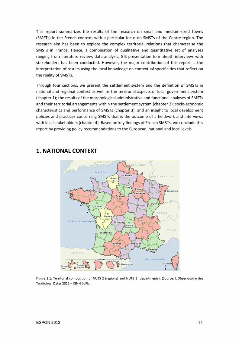
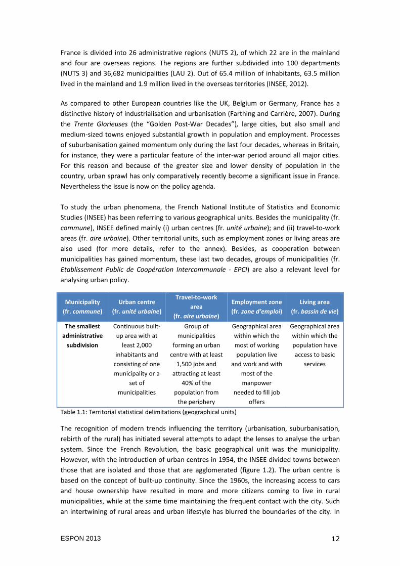
1. NATIONAL CONTEXT
Figure 1.1: Territorial composition of NUTS 2 (regions) and NUTS 3 (departments). (Source: L’Observatoire des
Territoires, Datar 2012 – IGN GéoFla).
ESPON 2013 12
France is divided into 26 administrative regions (NUTS 2), of which 22 are in the mainland
and four are overseas regions. The regions are further subdivided into 100 departments
(NUTS 3) and 36,682 municipalities (LAU 2). Out of 65.4 million of inhabitants, 63.5 million
lived in the mainland and 1.9 million lived in the overseas territories (INSEE, 2012).
As compared to other European countries like the UK, Belgium or Germany, France has a
distinctive history of industrialisation and urbanisation (Farthing and Carrière, 2007). During
the Trente Glorieuses (the “Golden Post-War Decades”), large cities, but also small and
medium-sized towns enjoyed substantial growth in population and employment. Processes
of suburbanisation gained momentum only during the last four decades, whereas in Britain,
for instance, they were a particular feature of the inter-war period around all major cities.
For this reason and because of the greater size and lower density of population in the
country, urban sprawl has only comparatively recently become a significant issue in France.
Nevertheless the issue is now on the policy agenda.
To study the urban phenomena, the French National Institute of Statistics and Economic
Studies (INSEE) has been referring to various geographical units. Besides the municipality (fr.
commune), INSEE defined mainly (i) urban centres (fr. unité urbaine); and (ii) travel-to-work
areas (fr. aire urbaine). Other territorial units, such as employment zones or living areas are
also used (for more details, refer to the annex). Besides, as cooperation between
municipalities has gained momentum, these last two decades, groups of municipalities (fr.
Etablissement Public de Coopération Intercommunale - EPCI) are also a relevant level for
analysing urban policy.
Municipality
(fr. commune)
Urban centre
(fr. unité urbaine)
Travel-to-work
area
(fr. aire urbaine)
Employment zone
(fr. zone d’emploi)
Living area
(fr. bassin de vie)
The smallest
administrative
subdivision
Continuous built-
up area with at
least 2,000
inhabitants and
consisting of one
municipality or a
set of
municipalities
Group of
municipalities
forming an urban
centre with at least
1,500 jobs and
attracting at least
40% of the
population from
the periphery
Geographical area
within which the
most of working
population live
and work and with
most of the
manpower
needed to fill job
offers
Geographical area
within which the
population have
access to basic
services
Table 1.1: Territorial statistical delimitations (geographical units)
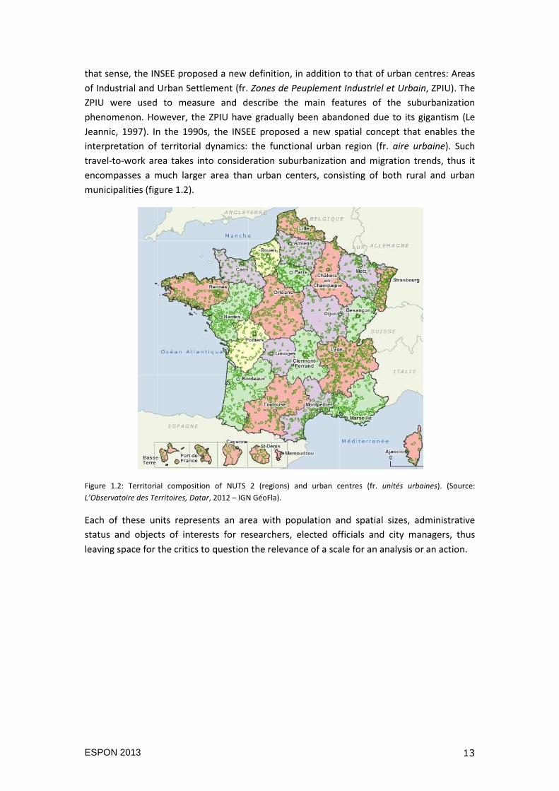
The recognition of modern trends influencing the territory (urbanisation, suburbanisation,
rebirth of the rural) has initiated several attempts to adapt the lenses to analyse the urban
system. Since the French Revolution, the basic geographical unit was the municipality.
However, with the introduction of urban centres in 1954, the INSEE divided towns between
those that are isolated and those that are agglomerated (figure 1.2). The urban centre is
based on the concept of built-up continuity. Since the 1960s, the increasing access to cars
and house ownership have resulted in more and more citizens coming to live in rural
municipalities, while at the same time maintaining the frequent contact with the city. Such
an intertwining of rural areas and urban lifestyle has blurred the boundaries of the city. In
ESPON 2013 13
that sense, the INSEE proposed a new definition, in addition to that of urban centres: Areas
of Industrial and Urban Settlement (fr. Zones de Peuplement Industriel et Urbain, ZPIU). The
ZPIU were used to measure and describe the main features of the suburbanization
phenomenon. However, the ZPIU have gradually been abandoned due to its gigantism (Le
Jeannic, 1997). In the 1990s, the INSEE proposed a new spatial concept that enables the
interpretation of territorial dynamics: the functional urban region (fr. aire urbaine). Such
travel-to-work area takes into consideration suburbanization and migration trends, thus it
encompasses a much larger area than urban centers, consisting of both rural and urban
municipalities (figure 1.2).
Figure 1.2: Territorial composition of NUTS 2 (regions) and urban centres (fr. unités urbaines). (Source:
L’Observatoire des Territoires, Datar, 2012 – IGN GéoFla).
Each of these units represents an area with population and spatial sizes, administrative
status and objects of interests for researchers, elected officials and city managers, thus
leaving space for the critics to question the relevance of a scale for an analysis or an action.
ESPON 2013 14
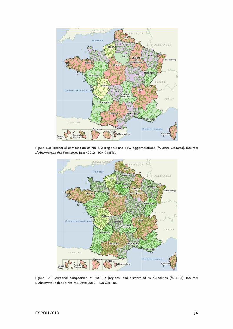
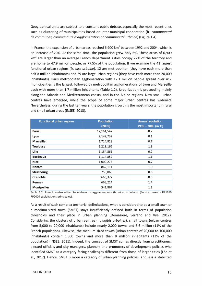
Figure 1.3: Territorial composition of NUTS 2 (regions) and TTW agglomerations (fr. aires urbaines). (Source:
L’Observatoire des Territoires, Datar 2012 – IGN GéoFla).
Figure 1.4: Territorial composition of NUTS 2 (regions) and clusters of municipalities (fr. EPCI). (Source:
L’Observatoire des Territoires, Datar 2012 – IGN GéoFla).
ESPON 2013 15
Geographical units are subject to a constant public debate, especially the most recent ones
such as clustering of municipalities based on inter-municipal cooperation (fr. communauté
de communes, communauté d’agglomération or communauté urbaine) (Figure 1.4).
In France, the expansion of urban areas reached 6 900 km2 between 1992 and 2004, which is
an increase of 20%. At the same time, the population grew only 6%. These areas of 6,900
km2 are larger than an average French department. Cities occupy 22% of the territory and
are home to 47.9 million people, or 77.5% of the population. If we examine the 41 largest
functional urban regions (fr. aire urbaine), 12 are metropolitan (they have each more than
half a million inhabitants) and 29 are large urban regions (they have each more than 20,000
inhabitants). Paris metropolitan agglomeration with 12.1 million people spread over 412
municipalities is the largest, followed by metropolitan agglomerations of Lyon and Marseille
each with more than 1.7 million inhabitants (Table 1.2). Urbanization is proceeding mainly
along the Atlantic and Mediterranean coasts, and in the Alpine regions. New small urban
centres have emerged, while the scope of some major urban centres has widened.
Nevertheless, during the last ten years, the population growth is the most important in rural
and small urban areas (INSEE, 2013).
Table 1.2: French metropolitan travel-to-work agglomerations (fr. aires urbaines). (Source: Insee - RP1999
RP2009 exploitations principales).
As a result of such complex territorial delimitations, what is considered to be a small town or
a medium-sized town (SMST) stays insufficiently defined both in terms of population
thresholds and their place in urban planning (Demazière, Serrano and Vye, 2012).
Considering the clusters of urban centres (fr. unités urbaines), small towns (urban centres
from 5,000 to 20,000 inhabitants) include nearly 2,000 towns and 6.6 million (11% of the
French population). Likewise, the medium-sized towns (urban centres of 20,000 to 100,000
inhabitants) contain 1 300 towns and more than 8 million inhabitants (13% of the
population) (INSEE, 2011). Indeed, the concept of SMST comes directly from practitioners,
elected officials and city managers, planners and promoters of development policies who
identified SMST as a category facing challenges different from those of larger cities (Léo et
al., 2012). Hence, SMST is more a category of urban planning policies, and less a stabilized
Functional urban regions Population
(2009)
Annual evolution
1999 – 2009 (in %)
Paris 12,161,542 0.7
Lyon 2,142,732 0.1
Marseille 1,714,828 0.7
Toulouse 1,218,166 1.8
Lille 1,154,861 0.2
Bordeaux 1,114,857 1.1
Nice 1,000,275 0,7
Nantes 862,111 1.0
Strasbourg 759,868 0.6
Grenoble 666,372 0.5
Rennes 663,214 1.4
Montpellier 542,867 1.3
ESPON 2013 16
concept in human geography or regional economy (Béhar, 2009). Therefore, both at national
and local levels it is acknowledged that research on SMSTs requires renewed theoretical and
methodological approach (Demazière et al., 2012).
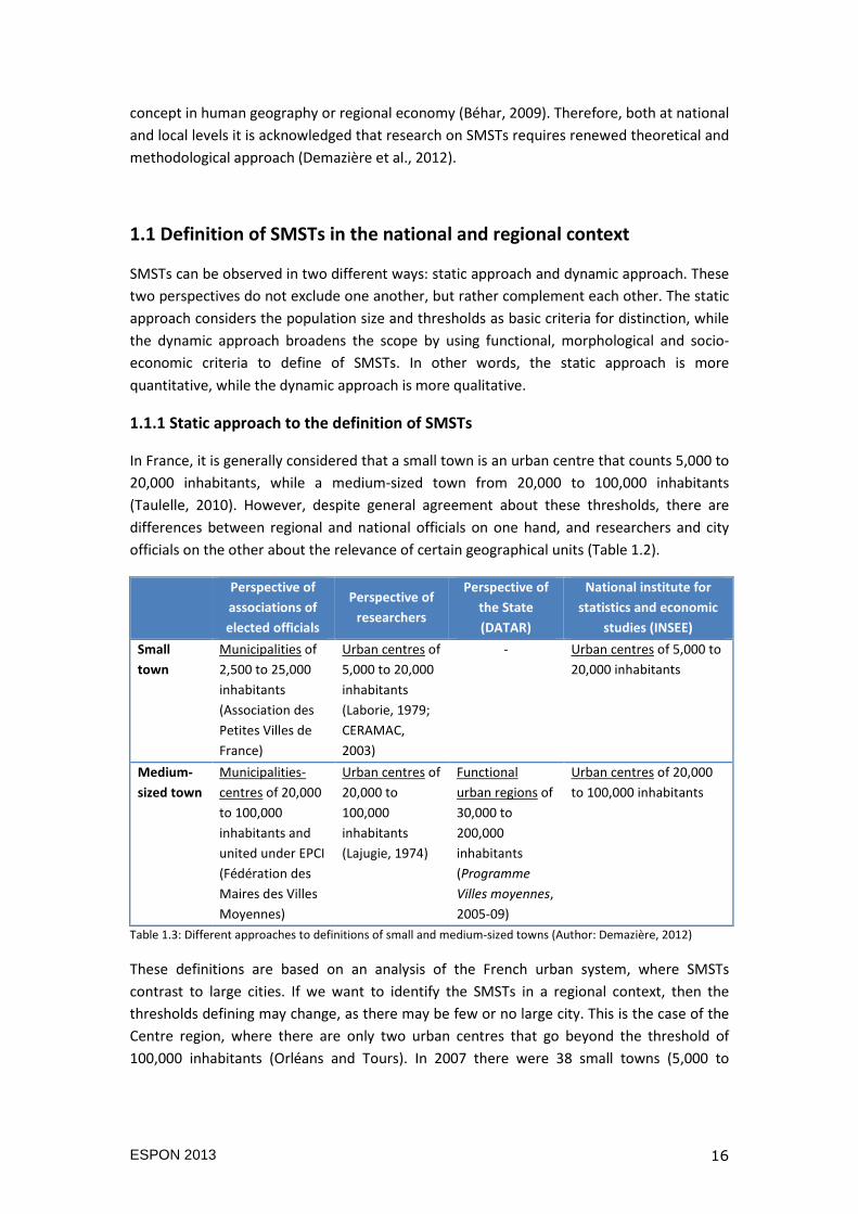
1.1 Definition of SMSTs in the national and regional context
SMSTs can be observed in two different ways: static approach and dynamic approach. These
two perspectives do not exclude one another, but rather complement each other. The static
approach considers the population size and thresholds as basic criteria for distinction, while
the dynamic approach broadens the scope by using functional, morphological and socio-
economic criteria to define of SMSTs. In other words, the static approach is more
quantitative, while the dynamic approach is more qualitative.
1.1.1 Static approach to the definition of SMSTs
In France, it is generally considered that a small town is an urban centre that counts 5,000 to
20,000 inhabitants, while a medium-sized town from 20,000 to 100,000 inhabitants
(Taulelle, 2010). However, despite general agreement about these thresholds, there are
differences between regional and national officials on one hand, and researchers and city
officials on the other about the relevance of certain geographical units (Table 1.2).
Perspective of
associations of
elected officials
Perspective of
researchers
Perspective of
the State
(DATAR)
National institute for
statistics and economic
studies (INSEE)
Small
town
Municipalities of
2,500 to 25,000
inhabitants
(Association des
Petites Villes de
France)
Urban centres of
5,000 to 20,000
inhabitants
(Laborie, 1979;
CERAMAC,
2003)
- Urban centres of 5,000 to
20,000 inhabitants
Medium-
sized town
Municipalities-
centres of 20,000
to 100,000
inhabitants and
united under EPCI
(Fédération des
Maires des Villes
Moyennes)
Urban centres of
20,000 to
100,000
inhabitants
(Lajugie, 1974)
Functional
urban regions of
30,000 to
200,000
inhabitants
(Programme
Villes moyennes,
2005-09)
Urban centres of 20,000
to 100,000 inhabitants
Table 1.3: Different approaches to definitions of small and medium-sized towns (Author: Demazière, 2012)
These definitions are based on an analysis of the French urban system, where SMSTs
contrast to large cities. If we want to identify the SMSTs in a regional context, then the
thresholds defining may change, as there may be few or no large city. This is the case of the
Centre region, where there are only two urban centres that go beyond the threshold of
100,000 inhabitants (Orléans and Tours). In 2007 there were 38 small towns (5,000 to
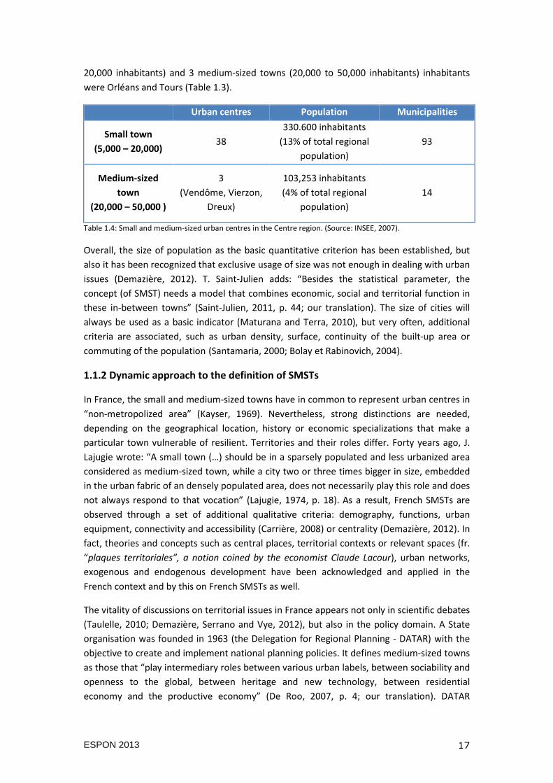
ESPON 2013 17
20,000 inhabitants) and 3 medium-sized towns (20,000 to 50,000 inhabitants) inhabitants
were Orléans and Tours (Table 1.3).
Urban centres Population Municipalities
Small town
(5,000 – 20,000) 38
330.600 inhabitants
(13% of total regional
population)
93
Medium-sized
town
(20,000 – 50,000 )
3
(Vendôme, Vierzon,
Dreux)
103,253 inhabitants
(4% of total regional
population)
14
Table 1.4: Small and medium-sized urban centres in the Centre region. (Source: INSEE, 2007).
Overall, the size of population as the basic quantitative criterion has been established, but
also it has been recognized that exclusive usage of size was not enough in dealing with urban
issues (Demazière, 2012). T. Saint-Julien adds: “Besides the statistical parameter, the
concept (of SMST) needs a model that combines economic, social and territorial function in
these in-between towns” (Saint-Julien, 2011, p. 44; our translation). The size of cities will
always be used as a basic indicator (Maturana and Terra, 2010), but very often, additional
criteria are associated, such as urban density, surface, continuity of the built-up area or
commuting of the population (Santamaria, 2000; Bolay et Rabinovich, 2004).
1.1.2 Dynamic approach to the definition of SMSTs
In France, the small and medium-sized towns have in common to represent urban centres in
“non-metropolized area” (Kayser, 1969). Nevertheless, strong distinctions are needed,
depending on the geographical location, history or economic specializations that make a
particular town vulnerable of resilient. Territories and their roles differ. Forty years ago, J.
Lajugie wrote: “A small town (…) should be in a sparsely populated and less urbanized area
considered as medium-sized town, while a city two or three times bigger in size, embedded
in the urban fabric of an densely populated area, does not necessarily play this role and does
not always respond to that vocation” (Lajugie, 1974, p. 18). As a result, French SMSTs are
observed through a set of additional qualitative criteria: demography, functions, urban
equipment, connectivity and accessibility (Carrière, 2008) or centrality (Demazière, 2012). In
fact, theories and concepts such as central places, territorial contexts or relevant spaces (fr.
“plaques territoriales”, a notion coined by the economist Claude Lacour), urban networks,
exogenous and endogenous development have been acknowledged and applied in the
French context and by this on French SMSTs as well.
The vitality of discussions on territorial issues in France appears not only in scientific debates
(Taulelle, 2010; Demazière, Serrano and Vye, 2012), but also in the policy domain. A State
organisation was founded in 1963 (the Delegation for Regional Planning - DATAR) with the
objective to create and implement national planning policies. It defines medium-sized towns
as those that “play intermediary roles between various urban labels, between sociability and
openness to the global, between heritage and new technology, between residential
economy and the productive economy” (De Roo, 2007, p. 4; our translation). DATAR

ESPON 2013 18
commissioned numerous studies on small and medium sized towns, from the 1970s to the
2000s (Laborie, 1973; Julien and Pougnard, 2004; Béhar, 2004), showing its interest for the
topic.
To conclude, the approach to SMSTs in France has overcome the static focus on the
population size and has become multifocal by observing networks and relations within
territory, urban hierarchy and socio-economical intermediation. Just as in many other
countries, the potential of SMSTs to generate growth and equilibrium between large
metropolitan centres and rural areas within processes of decentralisation, enforcement of
service sectors and local policies and actors, has been recognised in France as well (De Roo,
2007; Zuliani, 2004).
1.2 Literature overview of studies of settlement system and SMSTs
In France, there is a tradition of studying SMSTs through various social science disciplines:
regional and urban economics, geography, political science, planning, sociology… (Lajugie,
1974; Laborie, 1979; Mabileau and Sorbets, 1989; Commerçon and George, 1999, CERAMAC,
2003). Studies of SMSTs in France have seen two phases: the first in the 1960s and the 1970s
and the second in the 1990s and the 2000s. In the 1960s and with the creation of the
DATAR, the State’s objective was to establish “a hierarchical and balanced territory” where
“the dynamism of one area should reduce the decline of the other” (Béhar and Estèbe, 2004,
p. 268; our translation). During the 1960s, the state designated eight large conurbations as
“métropoles d’équilibre”. Through public investment, this policy aimed at raising the profile
of these cities, to stimulate economic development in advanced services and eventually to
reduce the gap with the Paris conurbations. Regarding medium-sized towns, concrete
actions were initiated at the beginning of the 1970s. From 1973 to 1982, 73 medium-sized
towns (defined as municipalities with 20,000 to 100,000 inhabitants) signed triennial
contracts with the State. The main objectives were to improve the quality of urban life and
to carry out equipping and economic development. These contracts defined the state will,
the provision of technical expertise and the coordination with local elected representatives
in the realization of projects considered as priorities (Carrier and Demazière, 2012). On one
hand, by this policy, local municipalities were mobilized so as to define local strategies. “On
the other hand, [the policy] looked more at the qualitative than quantitative effects, as it
was to develop towns on a “human scale” where the congestion and social segregation
related to large cities, would be avoided (Fabriès-Verfaillie et al., 1994, p. 176; our
translation). The diversification of functions of an urban centre and the strengthening of its
centrality were then considered as key foundations of a consolidated urban system that
benefits the hinterland. This policy was, in financial terms, as important as the “métropoles
d’équilibre” policy. Since then, associations of elected representatives of these cities (the
Association of Small Towns of France, the Federation of Mayors of Medium-Sized Towns)
were created to highlight the attributes of these territories and to recall issues of territorial
cohesion of these areas that are less affected by métropolisation (Demazière, 2012).
ESPON 2013 19
Following the period of policy implementation that had to consolidate the urban system in
the 1980s, the period after the 1990s, focused on the future of SMSTs in the new context of
metropolisation and new division of labour among territories (Fererol, 2010). The actors of
territorial development realized that planning could not be based solely on large cities, and
that the balance between territories could not any longer be established on a global vision
of the territory, but on the contrary - by placing ahead the context and the specificities of
each territory (Demazière, 2011). This may imply high expectations towards research which
aim to identify the role of SMSTs in the contemporary spatial, economic and social system
prior to any public policies.
1.2.1 The national level
Since its creation, the DATAR has been one of the most relevant actors in developing
territorial planning methods, experimentations and foresights. A pertinent study certainly
was the “Scenario of the unacceptable. Image of France in 2000” from 1971, that served as a
theoretical framework prior to the implementation of actions of the General planning
scheme of France (fr. Schéma général d’aménagement de la France). As the objective, at
that time, was to territorially re-balance the country, the DATAR came out with the vision of
France as a highly polarized country in case of business-as-usual, which provoked a huge
public discussion. Prospective programmes such as “France in 2015. Reorganization of the
national territory” published in 1993, and “France 2020. Moving territories” from 1999,
forced the DATAR to adapt its methods to be consistent with the changes in modes of public
action which were triggered by decentralization. Since the 1990s hundreds of researchers
and representatives from civil, economic and political spheres have been invited to share
their expertise. The most recent one, “Territories 2040, planning the change” initiated in
October 2009, tried to anticipate key actions and levers for long-term planning issues such
as the climate, energy or technology that will impact the future of the territories. Concerning
works on urban systems and metropolises after 2000, the DATAR commissioned two studies
which were published in 2012: “What metropolises in Europe? Comparative analysis” and
“French urban systems” (Halbert et al., 2012). Both studies highlight the importance of
various types of urban networks (asymmetric, intensive, diverse, specialised, transversal,
etc.). Nevertheless, in policy terms, more interest has been brought to large cities, and less
to smaller scales such as SMSTs. Since the early 2000s, metropolitan areas are seen by the
state as engines for national growth, whereas rural areas and SMSTs are supposed to have
far less potential. The French state initiated an Appel à cooperation métropolitaine, a
national policy encouraging French large cities to develop cooperation within and across
city-regions, sometimes including cross-border cooperation (Motte, 2007). This policy was
short-lived, but in 2010, in an Act reforming local bodies, the French State decided to offer
the possibility to create a new category of supramunicipal body (EPCI), the ‘métropole’. The
‘métropole’ gathers more than half a million inhabitants. It has the competencies of the
‘communauté urbaine’ but also some of the department and of the region.
As was mentioned before, when it comes to SMSTs, the DATAR initiated several important
studies. From 2004 to 2006, in collaboration with the National Federation of Medium-Sized
Towns (FMVM) and the Assembly of French Groupings of Municipalities (ADCF), a detailed
work based on three axes (observation, analysis and recommendation) was conducted on
ESPON 2013 20
medium-sized towns and their TTWs agglomerations of 30,000 to 200,000 inhabitants. The
final report “French medium-sized towns, challenges and prospects” was published in 2007
(De Roo, 2007). As a result of this report, the same year the Government launched a public
call for medium-sized towns to experiment the implementation and the territorial impact of
four major sectoral policies: higher education, healthcare, transport and urban renewal. This
experimental project “20 medium-sized towns as witnesses” was based on the method of
dialogue between three actors: local governments, the State and professionals. Ended in
2009, experiences coming from these towns were useful for detecting challenges and for
planning future exchanges at vertical and horizontal levels of governing. As a result of these
initiatives, the DATAR organized two annual national meetings (in 2009 and 2010) for SMSTs
representatives in order to continue with the dialogue.
The National Institute for Statistics and Economic Studies (INSEE) has been also conducting
several studies on subjects such as centrality and urban structure. Concerning SMSTs, the
INSEE published for FMVM an analysis “Panorama of medium-sized towns” (2011) that
covers socio-economic aspects of development of medium-sized towns. In particular,
through the functional analysis of employment, the analysis showed three dominating types
of towns: agglomerated, administrative and industrial.
1.2.2 The regional level
The small and medium-sized towns are facing different conditions in terms of their
demographics, productive or cultural influence at international, national or within a regional
area. We illustrate this using the example of the situation in the Centre Region that will be
presented in more detail in the Section 2. The Centre Region is the 4th French region in area
and 10th by the number of inhabitants. With the density of 66 inhabitants per km2, it is a
sparsely populated region. At the national level, it is positioned between different
development areas. Compared to the neighbouring Ile-de-France, the Centre Region is an
area providing functions and populations. Besides Ile-de-France, it is the most populated
region of the Paris Basin as well as the one of the fastest population growing regions (+0.4%
per year on average between 1999 and 2009). To the west, the Centre Region has
experienced the growing competition coming from the Atlantic area whose coastline and
identity attract students or active population (cities such as Rennes, Nantes and Bordeaux,
but also medium-sized towns such as Vannes or La Rochelle). Finally, the southern territories
of the region have been experiencing the population decline and aging, showing the profiles
close to those of the Limousin and Auvergne regions.
Since the 1970s, the role of the regional authorities (fr. Conseil Régional du Centre), as for
other regions in France, has been to assure the territorial development by implementations
of policy for provision of equipment and facilities to its municipalities. The reflections on
territorial development continue to spread in the early 2000s, when the Council of the
Centre region launched a policy called “Medium-sized towns”. However, with the creation of
various forms of inter-municipal cooperation, regions broadened their approach to local
territories by implementing contractual policy with these inter-municipal forms of
cooperation. “Contractual policy is one way to unite the territories for economic and social
ESPON 2013 21
development - adapted to the potential of each territory within the regional space”
(Demazière, 2011, p. 41).
Following a period of consultation and work that involved more than 4.000 people across 23
territorial forums, 6 thematic forums and 3 citizen panels, the Council of the Centre region
adopted in 2011 the “Regional Plan for Sustainable Development and Planning” (SRADDT).
The SRADDT gives a vision of the future development of the region based on three key
priorities: knowledge society, networked territories and mobility. In the part “Geographic
positioning and structure of the territory” the accent was put on dialogue of actors and on
balanced urban structure, in particular between the two regional agglomerations Tours and
Orléans and numerous SMSTs. Moreover, as part of the above mentioned Regional Plan, the
Council of the Centre region published a study “Look on the employment zones of the
Centre region” that covered the socio-economic aspects of all employment zones, both
those belonging to medium-sized towns and to larger cities.
Following the objectives of the Regional Plan to maximize the development potential of
each territory and to reduce disparities in living conditions of its inhabitants, the Centre
region very recently (in 2012) reintroduced a new territorial scale of action – living areas (fr.
bassin de vie). Living areas are defined as territories of ‘everyday life’, whether it is about the
area that is delimited based on job commuting or accessibility to services and equipment
(consuming). Thus, the 23 living areas in the Centre region are seen as the most suitable for
addressing the key issues of economic, social and environmental development of a territory
(including employment, housing, transportation, services). Since 2012, the Centre region has
been encouraging the dialogue between local actors at that particular scale, including:
representatives of groups of municipalities (communities of agglomeration, communities of
municipalities, unions of countries, medium-sized towns, etc.), important social and
economic actors (CESER, chambers, firms, associations, development councils, etc.) and
institutional partners (State, departments, agencies, etc.). As a result of these forums and
public discussions, the needs and priorities for future actions were identified in a document
named “Ambition 2020” for living areas. This document drafted a set of interventions of the
Centre region for living areas, which include both intervention within the framework of its
own competences (schools, training, regional transportation, economic development), and
interventions based on the support of other territorial communities.
1.2.3 The local level
Since 1988 and grouped around the Federation of Medium-Sized Towns (FMVM), mayors
and elected representatives of different municipal networks (fr. intercommunalités) such as
community of municipalities, community of agglomerations, urban communities or unions of
new agglomerations promote interests of medium-sized towns at the national level. In 2004,
the FMVM and the State-owned Deposits Fund (fr. Caisse des déôots et Consignations)
published a study, “Medium-sized towns: issues for territorial development” that covered
issues of regional policies in relation to medium-sized towns, development projects and
urban renewal, heritage and economic development. In 2005, as a result of close dialogue
with the government, the FMVM published “22 measures for medium-sized towns” through
which the organization gave its recommendations for future actions concerning medium-
ESPON 2013 22
sized towns. In 2008, the FMVM re-confirmed its priorities and principles and announced its
propositions for the action through the “Manifest of FMVM for attractive medium-sized
towns and inter-municipalities in France of solidarity”. They demanded more power and
resources for local institutions, decentralisation of public services and support for local
development (habitat, transport, healthcare, education and services).
In the Centre Region, in order to establish an exchange network and/or to weigh the choices
made by the state of the region, a group of elected officials was formed in the 1990s,
including towns such as Chinon, Montlouis, Dreux, Salbris, etc. These were towns and cities
of varying sizes and status. Since 2008s, the network has evolved into a forum of elected
representatives of SMSTs, who meet twice a year in order to discuss topics such as
participatory democracy, drivers of local economic development, etc. The resource centre
Villes au carré has been engaged in the organization of the network.
SMSTs have also beeen studied by academics (Laborie, 1996; Roques, 2010; Ferrerol, 2010).
In region Centre, the PhD work of Pasquet (1999) should be quoted. More recently, the
University of Tours in partnership with the universities of Orléans, Poitiers and La Rochelle
and with the resource center Villes au carré, and with the sponsorship of the Council of the
Centre region, organised the international conference “Small and medium-sized towns: a
fresh look” in 2010 in Tours. Attended by 200 researchers and professionals, the conference
enabled an exchange between all involved actors, but also it received papers relating to
major themes: (i) how to define a medium-sized town?; (ii) what is the place of a medium-
sized town in the region?; (iii) productive or residential: which economy for a medium-sized
town?; (iv) what are the implications of public policies?; (v) living in a medium-sized town.
Later on, a selection of papers was published in academic journals (Carrier and Demazière,
2012; Demazière, Serrano and Vye, 2012) or for practitioners (Villes au Carré, 2011;
Urbanisme, 2011).
In 2010 the Regional Directorate of Environment, Planning and Housing (DREAL) awarded
the University of Tours, a study on the development of medium-sized towns in the Centre
region (Demazière, 2011). In 2011, another project “Observation of economic and strategic
dynamics of SMSTs” (ODES), has been initiated by the University of Tours. The project was
supported and funded by the Council of the Centre region and it is still ongoing (Demazière,
2012).
1.3 Territorial aspects of the local government system
Since laws in 1871 and 1884, French municipalities and departments have had a limited
autonomy. However, in 1982 and 1983 with the acts known as Gaston Deferre Laws, French
parliament launched a policy of decentralisation. The process of decentralisation was
conducted in two stages. During 1980s it meant the transfer of powers and responsibilities
to newly created institutions and territorial governments (fr. collectivités territoriales). One
of introduced innovations was the creation of regions with full powers and recognition. The
second stage of decentralisation started in the early 2000s with the confirmation of the
three vertical levels of local government: municipality, department and region. However,
ESPON 2013 23
what is particular for France is the existence of different horizontal forms of inter-municipal
cooperation such as community of municipalities, community of agglomeration and urban
community. Even though the municipalities and their groupings are autonomous from the
department and the region, there exist strong relationships through the territorial contracts,
which will be detailed in the case of region Centre, in chapter 4.
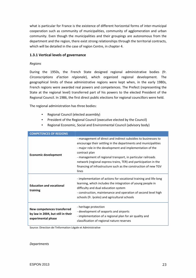
1.3.1 Vertical levels of governance
Regions
During the 1950s, the French State designed regional administrative bodies (fr.
Circonscriptions d’action régionale), which organized regional development. The
geographical limits of these administrative regions were kept when, in the early 1980s,
French regions were awarded real powers and competences. The Prefect (representing the
State at the regional level) transferred part of his powers to the elected President of the
Regional Council. In 1986, the first direct public elections for regional councillors were held.
The regional administration has three bodies:
• Regional Council (elected assembly)
• President of the Regional Council (executive elected by the Council)
• Regional Economic, Social and Environmental Council (advisory body)
COMPETENCES OF REGIONS
Economic development
- management of direct and indirect subsidies to businesses to
encourage their settling in the departments and municipalities
- major role in the development and implementation of the
contract plan
- management of regional transport, in particular railroads
network (regional express trains, TER) and participation in the
financing of infrastructure such as the construction of new TGV
lines
Education and vocational
training
- implementation of actions for vocational training and life-long
learning, which includes the integration of young people in
difficulty and dual education system
- construction, maintenance and operation of second level high
schools (fr. lycées) and agricultural schools
New competences transferred
by law in 2004, but still in their
experimental phase
- heritage protection
- development of seaports and airports
- implementation of a regional plan for air quality and
classification of regional nature reserves
Source: Direction de l’Information Légale et Administrative
Departments
ESPON 2013 24
Created after the French Revolution, departments had to ease the administration of the
government. The spatial delimitation of departments was made so that it was possible to
arrive to a departmental capital in one day of riding. Despite many critics, department with
its prefect (put by the State) became eventually essential for State administration at the
local level. However, since the decentralisation laws, the executive function of the prefect
was substantially downsized in favour of the elected president of the general counsel of the
Department. Departments are divided into districts (fr. cantons) that elect councillors for
departmental general councils.
COMPETENCES OF DEPARTMENTS
Social action
- childhood: maternal and child healthcare, adoption,
support for families in financial difficulty
- people with disabilities: policies for accommodation and
social inclusion, provision of disability compensation
- the elderly: creation and management of retirement
homes, policy of maintaining the elderly at home (personal
autonomy allowance)
- social assistance benefits: management of active
solidarity income
Education - construction, maintenance and equipment for first level
secondary schools (fr. 24colleges)
Planning
- rural infrastructure, land consolidation, land
management, water management, rural roads taking into
account the priorities identified by the municipalities
- fishing seaports, non-urban road transport of persons
- road extension and maintenance of all roads that do not
fall into the national public domain
Culture
- construction and managing departmental libraries,
county archives, museums
- heritage protection
Economic development - direct or indirect support
Source: Direction de l’Information Légale et Administrative
Municipalities
A municipality is the basic and the oldest administrative unit. It was introduced by law in
1790 when at the tile of the French Revolution all parishes, villages, towns and cities were
converted to municipalities. This explains their large number (more than 36.700
municipalities in 2011). Since the Municipal Act in 1884, municipalities have their own
administrative organization, regardless of their size:
• Municipal council (councillors are elected by direct universal suffrage)
• Mayor (elected by the council)
ESPON 2013 25
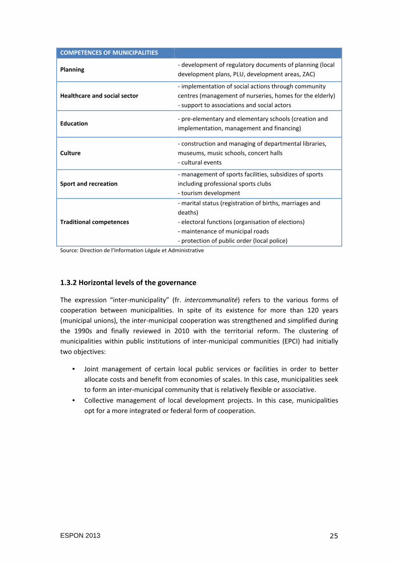
COMPETENCES OF MUNICIPALITIES
Planning - development of regulatory documents of planning (local
development plans, PLU, development areas, ZAC)
Healthcare and social sector
- implementation of social actions through community
centres (management of nurseries, homes for the elderly)
- support to associations and social actors
Education - pre-elementary and elementary schools (creation and
implementation, management and financing)
Culture
- construction and managing of departmental libraries,
museums, music schools, concert halls
- cultural events
Sport and recreation
- management of sports facilities, subsidizes of sports
including professional sports clubs
- tourism development
Traditional competences
- marital status (registration of births, marriages and
deaths)
- electoral functions (organisation of elections)
- maintenance of municipal roads
- protection of public order (local police)
Source: Direction de l’Information Légale et Administrative
1.3.2 Horizontal levels of the governance
The expression “inter-municipality” (fr. intercommunalité) refers to the various forms of
cooperation between municipalities. In spite of its existence for more than 120 years
(municipal unions), the inter-municipal cooperation was strengthened and simplified during
the 1990s and finally reviewed in 2010 with the territorial reform. The clustering of
municipalities within public institutions of inter-municipal communities (EPCI) had initially
two objectives:
• Joint management of certain local public services or facilities in order to better
allocate costs and benefit from economies of scales. In this case, municipalities seek
to form an inter-municipal community that is relatively flexible or associative.
• Collective management of local development projects. In this case, municipalities
opt for a more integrated or federal form of cooperation.
ESPON 2013 26
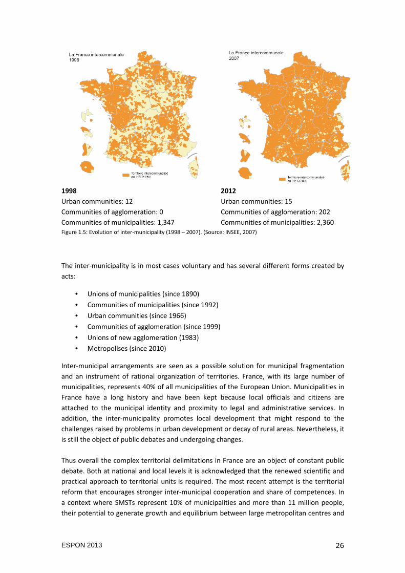
1998 2012
Urban communities: 12 Urban communities: 15
Communities of agglomeration: 0 Communities of agglomeration: 202
Communities of municipalities: 1,347 Communities of municipalities: 2,360 Figure 1.5: Evolution of inter-municipality (1998 – 2007). (Source: INSEE, 2007)
The inter-municipality is in most cases voluntary and has several different forms created by
acts:
• Unions of municipalities (since 1890)
• Communities of municipalities (since 1992)
• Urban communities (since 1966)
• Communities of agglomeration (since 1999)
• Unions of new agglomeration (1983)
• Metropolises (since 2010)
Inter-municipal arrangements are seen as a possible solution for municipal fragmentation
and an instrument of rational organization of territories. France, with its large number of
municipalities, represents 40% of all municipalities of the European Union. Municipalities in
France have a long history and have been kept because local officials and citizens are
attached to the municipal identity and proximity to legal and administrative services. In
addition, the inter-municipality promotes local development that might respond to the
challenges raised by problems in urban development or decay of rural areas. Nevertheless, it
is still the object of public debates and undergoing changes.
Thus overall the complex territorial delimitations in France are an object of constant public
debate. Both at national and local levels it is acknowledged that the renewed scientific and
practical approach to territorial units is required. The most recent attempt is the territorial
reform that encourages stronger inter-municipal cooperation and share of competences. In
a context where SMSTs represent 10% of municipalities and more than 11 million people,
their potential to generate growth and equilibrium between large metropolitan centres and
ESPON 2013 27
rural areas within processes of decentralisation, enforcement of service sectors and local
policies and actors, has become a wider public interest.
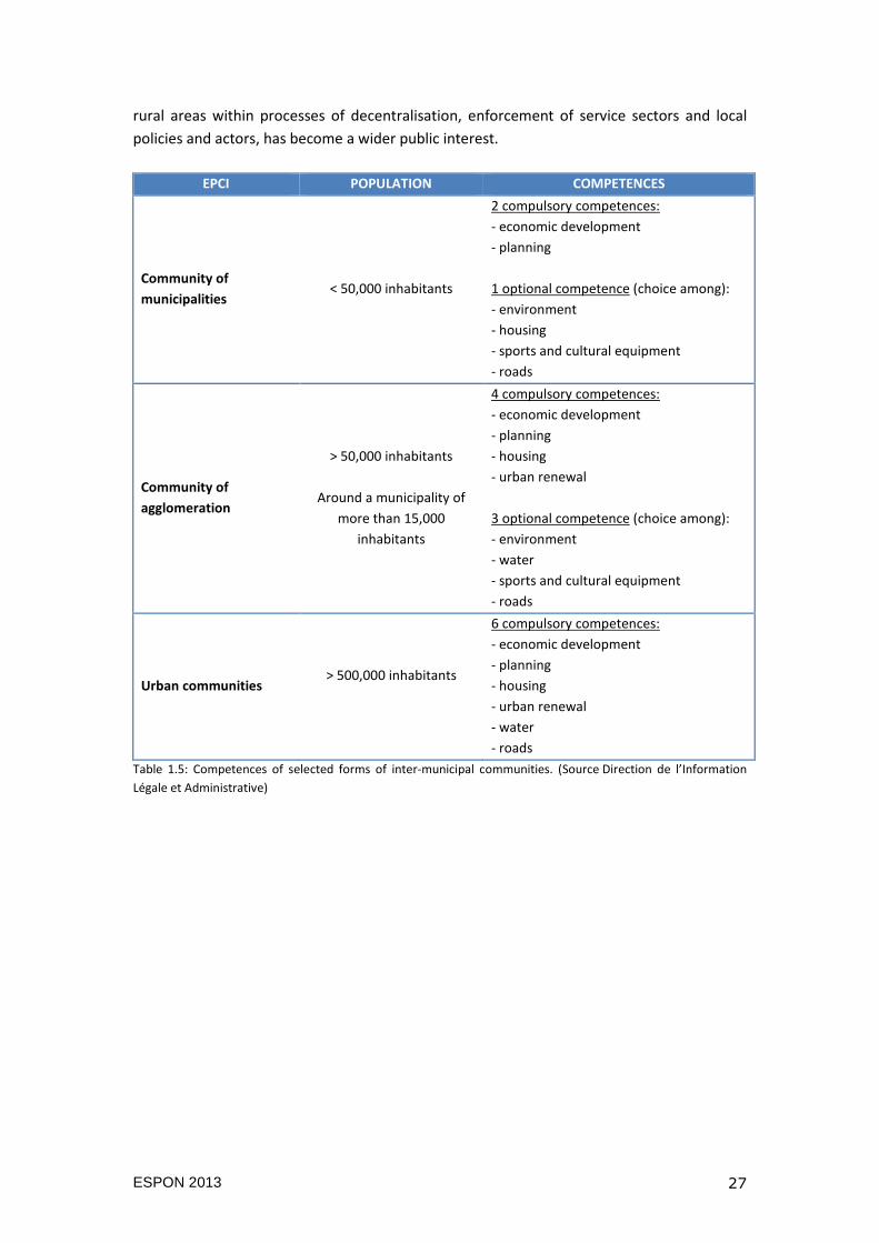
EPCI POPULATION COMPETENCES
Community of
municipalities < 50,000 inhabitants
2 compulsory competences:
- economic development
- planning
1 optional competence (choice among):
- environment
- housing
- sports and cultural equipment
- roads
Community of
agglomeration
> 50,000 inhabitants
Around a municipality of
more than 15,000
inhabitants
4 compulsory competences:
- economic development
- planning
- housing
- urban renewal
3 optional competence (choice among):
- environment
- water
- sports and cultural equipment
- roads
Urban communities > 500,000 inhabitants
6 compulsory competences:
- economic development
- planning
- housing
- urban renewal
- water
- roads
Table 1.5: Competences of selected forms of inter-municipal communities. (Source Direction de l’Information
Légale et Administrative)
ESPON 2013 28
2. TERRITORIAL IDENTIFICATION OF SMSTS
This chapter provides final results of the morphological-geomatic and functional-spatial
analyses conducted on the case of the Centre region (NUTS 2) including a detailed
observation of territorial relations between urban settlements. A special focus has been
given to the relation of SMSTs with large urban centres and very small towns. Firstly, we
present the observed territory: the Centre region. Secondly, we show results of the geomatic
morphological analysis applied in the delimitation of SMSTs from other urban settlements in
the case of study. Finally, we observe the job-commuting flow in order to identify the
functional micro-regions and their centres as well as their type of territorial arrangement
(autonomous, agglomerated or networked).
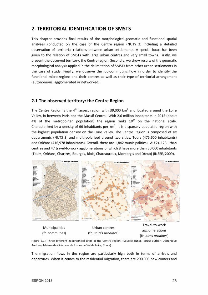
2.1 The observed territory: the Centre Region
The Centre Region is the 4th largest region with 39,000 km2 and located around the Loire
Valley, in between Paris and the Massif Central. With 2.6 million inhabitants in 2012 (about
4% of the metropolitan population) the region ranks 10th on the national scale.
Characterized by a density of 66 inhabitants per km2, it is a sparsely populated region with
the highest population density on the Loire Valley. The Centre Region is composed of six
departments (NUTS 3) and multi-polarised around two cities: Tours (475,600 inhabitants)
and Orléans (416,978 inhabitants). Overall, there are 1,842 municipalities (LAU 2), 123 urban
centres and 47 travel-to-work agglomerations of which 8 have more than 50 000 inhabitants
(Tours, Orléans, Chartres, Bourges, Blois, Chateauroux, Montargis and Dreux) (INSEE, 2009).
Municipalities
(fr. communes)
Urban centres
(fr. unités urbaines)
Travel-to-work
agglomerations
(fr. aires urbaines) Figure 2.1.: Three different geographical units in the Centre region. (Source: INSEE, 2010; author: Dominique
Andrieu, Maison des Sciences de l’Homme Val de Loire, Tours).
The migration flows in the region are particularly high both in terms of arrivals and
departures. When it comes to the residential migration, there are 200,000 new comers and
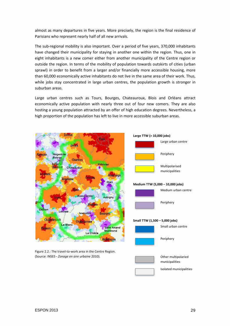
ESPON 2013 29
almost as many departures in five years. More precisely, the region is the final residence of
Parisians who represent nearly half of all new arrivals.
The sub-regional mobility is also important. Over a period of five years, 370,000 inhabitants
have changed their municipality for staying in another one within the region. Thus, one in
eight inhabitants is a new comer either from another municipality of the Centre region or
outside the region. In terms of the mobility of population towards outskirts of cities (urban
sprawl) in order to benefit from a larger and/or financially more accessible housing, more
than 60,000 economically active inhabitants do not live in the same area of their work. Thus,
while jobs stay concentrated in large urban centres, the population growth is stronger in
suburban areas.
Large urban centres such as Tours, Bourges, Chateauroux, Blois and Orléans attract
economically active population with nearly three out of four new comers. They are also
hosting a young population attracted by an offer of high education degrees. Nevertheless, a
high proportion of the population has left to live in more accessible suburban areas.
Figure 2.2.: The travel-to-work area in the Centre Region.
(Source: INSEE– Zonage en aire urbaine 2010).
Large TTW (> 10,000 jobs)
Large urban centre
Periphery
Multipolarised
municipalities
Medium TTW (5,000 – 10,000 jobs)
Medium urban centre
Periphery
Small TTW (1,500 – 5,000 jobs)
Small urban centre
Periphery
Other multipolaried
municipalities
Isolated municipalities
ESPON 2013 30
Small and medium-sized urban centres located south of the Centre region such as Le Blanc,
La Chatre, Argenton-sur-Creuse, Sancerre, Aubigny and Saint-Amand-Montrond have seen
the growth in population mainly related to the suburbanization of larger urban centres
(Bourges and Chateauroux) and the arrival of retired population. Nevertheless, these urban
centres have shown less dynamism in terms of provision of jobs and services to its
population.
On the other hand, small and medium-sized urban centres such as Montargis, Gien,
Vendôme, Loches and Romorantin-Lanthenay, besides a positive net migration for
economically active and retired categories of population, have seen more positive dynamics
in employment as they benefit from the proximity to major economic centres of the Loire
valley (Orléans and Tours) and the Ile-de-France Region.
Finally, urban centres such as Chinon, Chartres, Dunois, Perche and Pithiviers have had a
strong out-commuting of the economically active population. More precisely, the out-
commuting is characterized by a larger distance of the workplace (in large agglomerations of
Paris, Tours and Orléans) from the place of living that is possible due to the existence of
transport infrastructure.
2.2 Identification of SMSTs by means of morphological-geomatic
analysis
Based on population and density criteria, the morphological-geomatic analysis has identified
three types of polygons by aggregation of cell grids with given characteristics: SMSTs, high-
density urban clusters (HDUC) and very small town (VST). The population and density
thresholds used for the classification of urban settlements (represented through polygons)
into SMST, HDUC, and VST are presented in the Table 2.1.
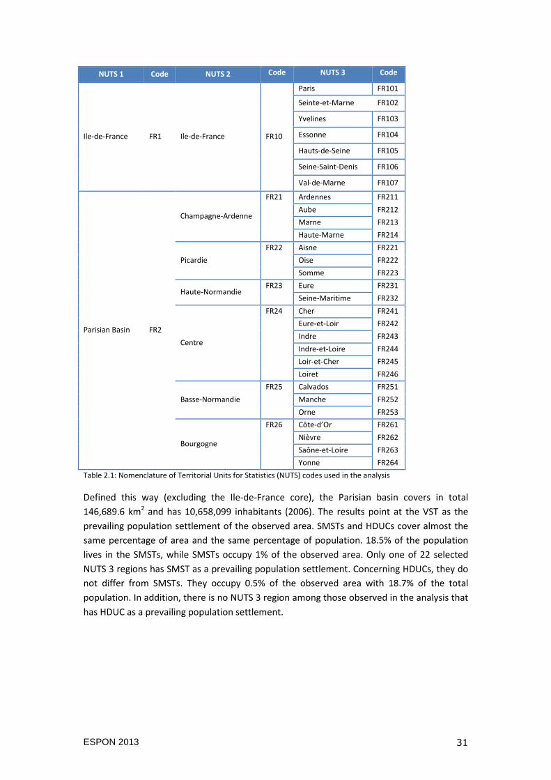
The analysis has been conducted on the NUTS 1 region of the Parisian Basin. This
corresponds to 6 NUTS 2 regions (Champagne-Ardenne, Picardie, Haute-Normandie, Centre,
Basse-Normandie and Bourgogne) and to 22 NUTS 3 regions (Table 2.1).
ESPON 2013 31
NUTS 1 Code NUTS 2 Code NUTS 3 Code
Ile-de-France FR1 Ile-de-France FR10
Paris FR101
Seinte-et-Marne FR102
Yvelines FR103
Essonne FR104
Hauts-de-Seine FR105
Seine-Saint-Denis FR106
Val-de-Marne FR107
Parisian Basin FR2
Champagne-Ardenne
FR21 Ardennes FR211
Aube FR212
Marne FR213
Haute-Marne FR214
Picardie
FR22 Aisne FR221
Oise FR222
Somme FR223
Haute-Normandie FR23 Eure FR231
Seine-Maritime FR232
Centre
FR24 Cher FR241
Eure-et-Loir FR242
Indre FR243
Indre-et-Loire FR244
Loir-et-Cher FR245
Loiret FR246
Basse-Normandie
FR25 Calvados FR251
Manche FR252
Orne FR253
Bourgogne
FR26 Côte-d’Or FR261
Nièvre FR262
Saône-et-Loire FR263
Yonne FR264
Table 2.1: Nomenclature of Territorial Units for Statistics (NUTS) codes used in the analysis
Defined this way (excluding the Ile-de-France core), the Parisian basin covers in total
146,689.6 km2 and has 10,658,099 inhabitants (2006). The results point at the VST as the
prevailing population settlement of the observed area. SMSTs and HDUCs cover almost the
same percentage of area and the same percentage of population. 18.5% of the population
lives in the SMSTs, while SMSTs occupy 1% of the observed area. Only one of 22 selected
NUTS 3 regions has SMST as a prevailing population settlement. Concerning HDUCs, they do
not differ from SMSTs. They occupy 0.5% of the observed area with 18.7% of the total
population. In addition, there is no NUTS 3 region among those observed in the analysis that
has HDUC as a prevailing population settlement.
ESPON 2013 32
Potential
NUTS1
case
Population
(2006)
Area
sq.km
(2006)
n. of
NUTS3
%
population
living in
SMST
% area
occupied
by SMST
n. of
NUTS3
regions
with SMST
as
prevailing
population
settlement
%
population
living in
HDUC
% area
occupied
by HDUC
n. of
NUTS3
regions
with HDUC
as
prevailing
population
settlement
Parisian
Basin
(FR2)
10,658,099 146,
689.6 22 18.5% 1% 1 18.7% 0.5% 0
Table 2.2: Characteristics of the Paris Basin (NUTS 1)
In order to compare morphological-geomatic results with the official data of the French
institute for statistics and economic studies (fr. INSEE), and having in mind the complexity
when it comes to the definition of a town (Chapter 1), we have used the urban centre (fr.
unité urbaine)1 as a territorial unit corresponding to the polygons derived from the
morphological-geomatic analysis.
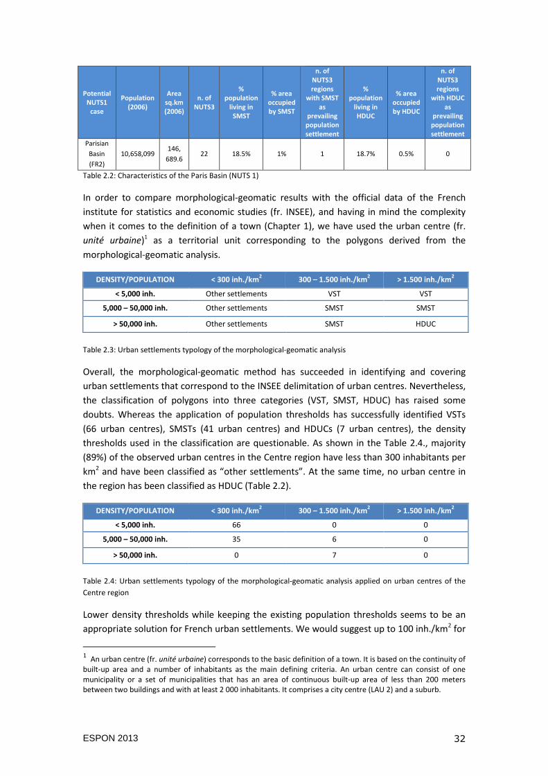
DENSITY/POPULATION < 300 inh./km2 300 – 1.500 inh./km
2 > 1.500 inh./km
2
< 5,000 inh. Other settlements VST VST
5,000 – 50,000 inh. Other settlements SMST SMST
> 50,000 inh. Other settlements SMST HDUC
Table 2.3: Urban settlements typology of the morphological-geomatic analysis
Overall, the morphological-geomatic method has succeeded in identifying and covering
urban settlements that correspond to the INSEE delimitation of urban centres. Nevertheless,
the classification of polygons into three categories (VST, SMST, HDUC) has raised some
doubts. Whereas the application of population thresholds has successfully identified VSTs
(66 urban centres), SMSTs (41 urban centres) and HDUCs (7 urban centres), the density
thresholds used in the classification are questionable. As shown in the Table 2.4., majority
(89%) of the observed urban centres in the Centre region have less than 300 inhabitants per
km2 and have been classified as “other settlements”. At the same time, no urban centre in
the region has been classified as HDUC (Table 2.2).
DENSITY/POPULATION < 300 inh./km2 300 – 1.500 inh./km
2 > 1.500 inh./km
2
< 5,000 inh. 66 0 0
5,000 – 50,000 inh. 35 6 0
> 50,000 inh. 0 7 0
Table 2.4: Urban settlements typology of the morphological-geomatic analysis applied on urban centres of the
Centre region
Lower density thresholds while keeping the existing population thresholds seems to be an
appropriate solution for French urban settlements. We would suggest up to 100 inh./km2 for
1 An urban centre (fr. unité urbaine) corresponds to the basic definition of a town. It is based on the continuity of built-up area and a number of inhabitants as the main defining criteria. An urban centre can consist of one municipality or a set of municipalities that has an area of continuous built-up area of less than 200 meters between two buildings and with at least 2 000 inhabitants. It comprises a city centre (LAU 2) and a suburb.
ESPON 2013 33
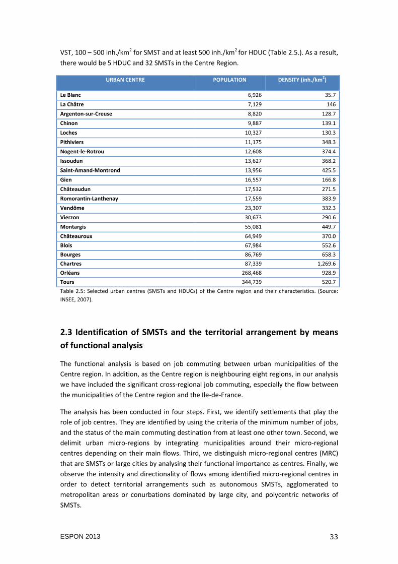
VST, 100 – 500 inh./km2 for SMST and at least 500 inh./km2 for HDUC (Table 2.5.). As a result,
there would be 5 HDUC and 32 SMSTs in the Centre Region.
URBAN CENTRE POPULATION DENSITY (inh./km2)
Le Blanc 6,926 35.7
La Châtre 7,129 146
Argenton-sur-Creuse 8,820 128.7
Chinon 9,887 139.1
Loches 10,327 130.3
Pithiviers 11,175 348.3
Nogent-le-Rotrou 12,608 374.4
Issoudun 13,627 368.2
Saint-Amand-Montrond 13,956 425.5
Gien 16,557 166.8
Châteaudun 17,532 271.5
Romorantin-Lanthenay 17,559 383.9
Vendôme 23,307 332.3
Vierzon 30,673 290.6
Montargis 55,081 449.7
Châteauroux 64,949 370.0
Blois 67,984 552.6
Bourges 86,769 658.3
Chartres 87,339 1,269.6
Orléans 268,468 928.9
Tours 344,739 520.7
Table 2.5: Selected urban centres (SMSTs and HDUCs) of the Centre region and their characteristics. (Source:
INSEE, 2007).
2.3 Identification of SMSTs and the territorial arrangement by means
of functional analysis
The functional analysis is based on job commuting between urban municipalities of the
Centre region. In addition, as the Centre region is neighbouring eight regions, in our analysis
we have included the significant cross-regional job commuting, especially the flow between
the municipalities of the Centre region and the Ile-de-France.
The analysis has been conducted in four steps. First, we identify settlements that play the
role of job centres. They are identified by using the criteria of the minimum number of jobs,
and the status of the main commuting destination from at least one other town. Second, we
delimit urban micro-regions by integrating municipalities around their micro-regional
centres depending on their main flows. Third, we distinguish micro-regional centres (MRC)
that are SMSTs or large cities by analysing their functional importance as centres. Finally, we
observe the intensity and directionality of flows among identified micro-regional centres in
order to detect territorial arrangements such as autonomous SMSTs, agglomerated to
metropolitan areas or conurbations dominated by large city, and polycentric networks of
SMSTs.
ESPON 2013 34
2.3.1 Identification of job centres, micro-regions and micro-regional centres
Based on the job-commuting data for the year 2009, we have identified 82 SMSTs and large
cities that have at least 1,000 jobs. These job centres differ in number of jobs (from 1,017 to
152,642 jobs) and in size of population (2,586 to 345,575 inhabitants).
Likewise, we have identified 20 SMSTs and large cities (Paris included) that have a role of
centres of their micro-regions (MRCs). They represent the main job-commuting destinations
for their neighbouring municipalities and count at least 8 000 inhabitants and 3 000 jobs
(Table 2.6.).
Code
MRC Name of the micro-regional centre Population Number of jobs
36203 Argenton-sur-Creuse 8,767 3,000
45302 Sully-sur-Loire 11,911 4,008
37111 Chinon 9,709 4,020
37301 Loches 10,459 4,108
28301 Nogent-le-Rotrou 12,312 4,617
45301 Pithiviers 11,309 4,678
36301 Issoudun 13,230 5,195
41301 Romorantin-Lanthenay 17,092 6,303
28302 Châteaudun 17,496 6,654
45303 Gien 16,294 7,486
41401 Vendôme 23,650 8,493
18401 Vierzon 30,051 9,630
28401 Dreux 47,693 18,035
45501 Montargis 54,754 19,868
36501 Châteauroux 64,122 28,675
41501 Blois 66,149 31,418
18501 Bourges 82,595 34,589
28501 Chartres 87,463 39,260
45701 Orléans 268,922 130,666
37701 Tours 345,575 152,642
00854 Paris 10,413,386 5,276,747
Table 2.6: Identified micro-regional centres and their characteristics. (Source: INSEE, 2009).
The towns that do not meet the criteria of: (i) having at least 3,000 jobs, or (ii) that are not
significant commuting destination of another town, are assigned to neighbouring MRCs that
meet those criteria. For example, SMSTs such as Saint-Amand-Montrond, Saint-Lubin-des-
Joncheret-Nonancourt, Ezy-sur-Eure and Epernon meet the criterion of minimal number of
jobs, but are not among significant flows of other towns/cities, thus they do not form their
own micro-regions but are assigned to other MRCs. On the contrary, four SMSTs: Vierzon,
Nogent-le-Rotrou, Issoudun and Sully-sur-Loire meet the criterion of minimal number of jobs
and they are among significant flows of other towns/cities, so they form their own micro-
regions consisting of their municipalities and are identified as MRCs.
ESPON 2013 35
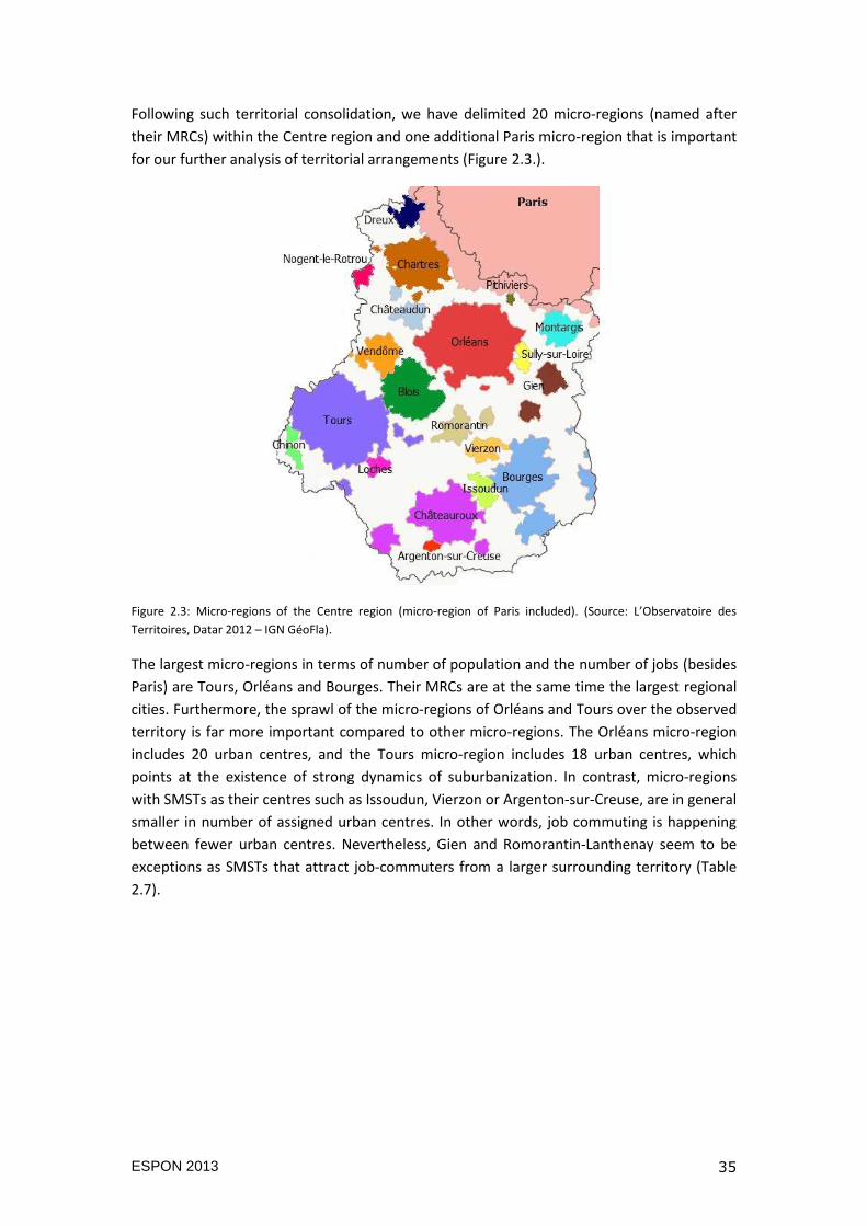
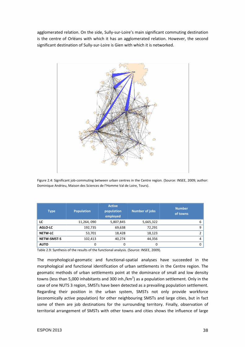
Following such territorial consolidation, we have delimited 20 micro-regions (named after
their MRCs) within the Centre region and one additional Paris micro-region that is important
for our further analysis of territorial arrangements (Figure 2.3.).
Figure 2.3: Micro-regions of the Centre region (micro-region of Paris included). (Source: L’Observatoire des
Territoires, Datar 2012 – IGN GéoFla).
The largest micro-regions in terms of number of population and the number of jobs (besides
Paris) are Tours, Orléans and Bourges. Their MRCs are at the same time the largest regional
cities. Furthermore, the sprawl of the micro-regions of Orléans and Tours over the observed
territory is far more important compared to other micro-regions. The Orléans micro-region
includes 20 urban centres, and the Tours micro-region includes 18 urban centres, which
points at the existence of strong dynamics of suburbanization. In contrast, micro-regions
with SMSTs as their centres such as Issoudun, Vierzon or Argenton-sur-Creuse, are in general
smaller in number of assigned urban centres. In other words, job commuting is happening
between fewer urban centres. Nevertheless, Gien and Romorantin-Lanthenay seem to be
exceptions as SMSTs that attract job-commuters from a larger surrounding territory (Table
2.7).
ESPON 2013 36
Micro-regions** Population Active population
employed Number of jobs
Number of assigned
urban centres
Blois 91,284 36,519 37,766 7
Bourges 132,384 50,501 50,186 10
Chartres 114,628 48,489 47,802 9
Châteaudun 26,404 9,519 9,243 3
Châteauroux 106,370 42,206 41,890 10
Chinon 22,924 8,692 8,937 4
Dreux 62,718 22,601 22,941 3
Gien 42,661 16,678 17,754 8
Montargis 81,099 29,399 29,332 7
Orléans 359,487 156,770 157,871 20
Paris* 12,161,542 6,195,444 5,758,403 7*
Pithiviers 14,605 5,678 5,884 2
Romorantin-Lanthenay 35,471 12,456 11,839 6
Tours 431,696 179,065 177,019 18
Vendôme 30,897 11,098 11,051 3
Vierzon 30,051 9,917 9,630 1
Nogent-le-Rotrou 12,312 4,711 4,617 1
Issoudun 13,230 4,947 5,195 1
Sully-sur-Loire 11,911 4,670 4,008 1
Loches 13,292 4,874 4,936 2
Argenton-sur-Creuse 8,767 3,296 3,000 1
* The number represents only the UUs of the Centre region assigned to the macro-region of Paris
**The name of a micro-region corresponds to the name of its centre (micro-regional centre)
Table 2.7.: Micro-regions of the Centre region (micro-region of Paris included) and their characteristics. (Source:
INSEE, 2009).
2.3.2 Identification of territorial arrangements and final typology
For the second phase of the functional analysis that explores relations between SMSTs and
large cities, we refer to significant flows between MRCs and their characteristics: (i) share of
out-commuters in active population of the MRC of source; (ii) share of out-commuters in
number of jobs of the MRC of destination. The identification of territorial arrangements is
made in two steps. We calculate the value of functional position of MRCs in the urban
system based on the number of significant commuting. Then, we identify SMSTs and large
cities that are autonomous, agglomerated or networked micro-regional centres based on the
previously mentioned characteristics of out-commuters of MRCs.
Therefore, we have identified 16 SMSTs and 6 large cities that are centres of micro-regions.
We have included the MRC of Paris due to the fact that it is a significant job-commuting
destination for towns and cities of the Centre region. Since all MRCs have significant
incoming and out-going flows, we observe that there is no autonomous (isolated) micro-
regional centre in our case of study. Regarding the other types of territorial arrangements,
the majority of MRCs that are SMSTs are agglomerated to larger MRCs (13 agglomerated
MRCs). On the other hand, six MRCs that are SMSTs are networked with other MRCs (2
SMSTs are networked with larger cities, while 4 SMSTs are networked with other SMSTs)
(Table 2.8.).
ESPON 2013 37
Type Population
Active
population
employed
Number
of jobs Micro-regional centres
LC 11,264,090 5,807,845 5,665,
322
Paris, Blois, Bourges, Chartres, Orléans, Tours
AGLO-LC*
192,735 69,638 72,291 Châteaudun (agglomerated to Chartres),
Chinon (agglomerated to Tours),
Dreux (agglomerated to Paris),
Loches (agglomerated to Tours),
Montargis (agglomerated to Paris),
Nogent-le-Rotrou (agglomerated to Chartres),
Pithiviers (agglomerated to Paris),
Romorantin-Lanthenay (agglomerated to
Blois),
Sully-sur-Loire (agglomerated to Orléans)
NETW-LC** 53,701 18,428 18,123 Vendôme (networked with Blois),
Vierzon (networked with Bourges)
NETW-SMST-S***
102,413 40,274 44,356 Châteauroux networked with Issoudun,
Gien networked with Sully-sur-Loire,
Issoudun networked with Châteauroux,
Argenton-sur-Creuse networked with
Châteauroux
AUTO 0 0 0 None
* in bold SMSTs are followed by the name of the large city they are agglomerated to.
** in bold SMSTs are followed by the name of the large city they are networked to.
*** in bold SMSTs are followed by the name of the SMST they are networked to.
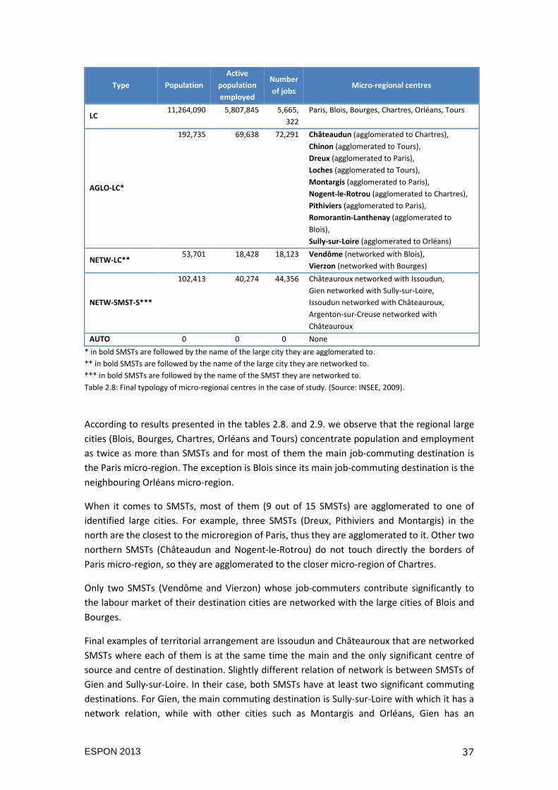
Table 2.8: Final typology of micro-regional centres in the case of study. (Source: INSEE, 2009).
According to results presented in the tables 2.8. and 2.9. we observe that the regional large
cities (Blois, Bourges, Chartres, Orléans and Tours) concentrate population and employment
as twice as more than SMSTs and for most of them the main job-commuting destination is
the Paris micro-region. The exception is Blois since its main job-commuting destination is the
neighbouring Orléans micro-region.
When it comes to SMSTs, most of them (9 out of 15 SMSTs) are agglomerated to one of
identified large cities. For example, three SMSTs (Dreux, Pithiviers and Montargis) in the
north are the closest to the microregion of Paris, thus they are agglomerated to it. Other two
northern SMSTs (Châteaudun and Nogent-le-Rotrou) do not touch directly the borders of
Paris micro-region, so they are agglomerated to the closer micro-region of Chartres.
Only two SMSTs (Vendôme and Vierzon) whose job-commuters contribute significantly to
the labour market of their destination cities are networked with the large cities of Blois and
Bourges.
Final examples of territorial arrangement are Issoudun and Châteauroux that are networked
SMSTs where each of them is at the same time the main and the only significant centre of
source and centre of destination. Slightly different relation of network is between SMSTs of
Gien and Sully-sur-Loire. In their case, both SMSTs have at least two significant commuting
destinations. For Gien, the main commuting destination is Sully-sur-Loire with which it has a
network relation, while with other cities such as Montargis and Orléans, Gien has an
ESPON 2013 38
agglomerated relation. On the side, Sully-sur-Loire’s main significant commuting destination
is the centre of Orléans with which it has an agglomerated relation. However, the second
significant destination of Sully-sur-Loire is Gien with which it is networked.
Figure 2.4: Significant job-commuting between urban centres in the Centre region. (Source: INSEE, 2009; author:
Dominique Andrieu, Maison des Sciences de l’Homme Val de Loire, Tours).
Type Population
Active
population
employed
Number of jobs Number
of towns
LC 11,264, 090 5,807,845 5,665,322 6
AGLO-LC 192,735 69,638 72,291 9
NETW-LC 53,701 18,428 18,123 2
NETW-SMST-S 102,413 40,274 44,356 4
AUTO 0 0 0 0
Table 2.9: Synthesis of the results of the functional analysis. (Source: INSEE, 2009).
The morphological-geomatic and functional-spatial analyses have succeeded in the
morphological and functional identification of urban settlements in the Centre region. The
geomatic methods of urban settlements point at the dominance of small and low density
towns (less than 5,000 inhabitants and 300 inh./km2) as a population settlement. Only in the
case of one NUTS 3 region, SMSTs have been detected as a prevailing population settlement.
Regarding their position in the urban system, SMSTs not only provide workforce
(economically active population) for other neighbouring SMSTs and large cities, but in fact
some of them are job destinations for the surrounding territory. Finally, observation of
territorial arrangement of SMSTs with other towns and cities shows the influence of large

ESPON 2013 39
cities over SMSTs. In most cases, commuters leaving SMSTs to work in large cities might be a
significant in number for the labour market of SMSTs, but are not representing as significant
percentage in the labour market of the large city. Two SMSTs (Vendôme and Vierzon) are
exceptions to that rule: they provide jobs to active population from, respectively, Blois and
Chateauroux. On the other side, when it comes to networks between towns and cities, in
our case study we observe more networks between two SMSTs, and fewer networks
between SMSTs and large cities.
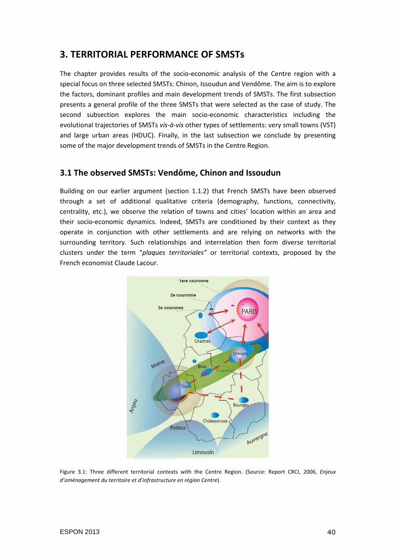
ESPON 2013 40
3. TERRITORIAL PERFORMANCE OF SMSTs
The chapter provides results of the socio-economic analysis of the Centre region with a
special focus on three selected SMSTs: Chinon, Issoudun and Vendôme. The aim is to explore
the factors, dominant profiles and main development trends of SMSTs. The first subsection
presents a general profile of the three SMSTs that were selected as the case of study. The
second subsection explores the main socio-economic characteristics including the
evolutional trajectories of SMSTs vis-à-vis other types of settlements: very small towns (VST)
and large urban areas (HDUC). Finally, in the last subsection we conclude by presenting
some of the major development trends of SMSTs in the Centre Region.
3.1 The observed SMSTs: Vendôme, Chinon and Issoudun
Building on our earlier argument (section 1.1.2) that French SMSTs have been observed
through a set of additional qualitative criteria (demography, functions, connectivity,
centrality, etc.), we observe the relation of towns and cities’ location within an area and
their socio-economic dynamics. Indeed, SMSTs are conditioned by their context as they
operate in conjunction with other settlements and are relying on networks with the
surrounding territory. Such relationships and interrelation then form diverse territorial
clusters under the term “plaques territoriales” or territorial contexts, proposed by the
French economist Claude Lacour.
Figure 3.1: Three different territorial contexts with the Centre Region. (Source: Report CRCI, 2006, Enjeux
d’aménagement du territoire et d’infrastructure en région Centre).
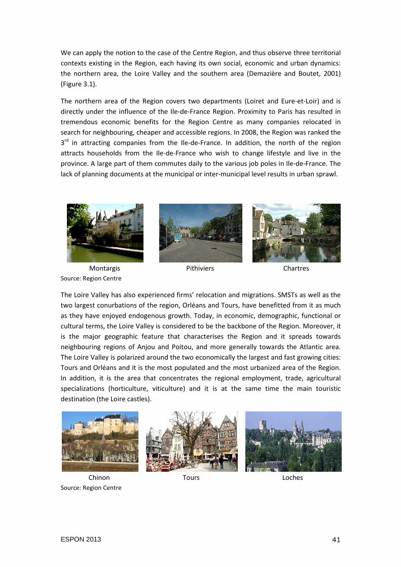
ESPON 2013 41
We can apply the notion to the case of the Centre Region, and thus observe three territorial
contexts existing in the Region, each having its own social, economic and urban dynamics:
the northern area, the Loire Valley and the southern area (Demazière and Boutet, 2001)
(Figure 3.1).
The northern area of the Region covers two departments (Loiret and Eure-et-Loir) and is
directly under the influence of the Ile-de-France Region. Proximity to Paris has resulted in
tremendous economic benefits for the Region Centre as many companies relocated in
search for neighbouring, cheaper and accessible regions. In 2008, the Region was ranked the
3rd in attracting companies from the Ile-de-France. In addition, the north of the region
attracts households from the Ile-de-France who wish to change lifestyle and live in the
province. A large part of them commutes daily to the various job poles in Ile-de-France. The
lack of planning documents at the municipal or inter-municipal level results in urban sprawl.
Montargis Pithiviers Chartres
Source: Region Centre
The Loire Valley has also experienced firms’ relocation and migrations. SMSTs as well as the
two largest conurbations of the region, Orléans and Tours, have benefitted from it as much
as they have enjoyed endogenous growth. Today, in economic, demographic, functional or
cultural terms, the Loire Valley is considered to be the backbone of the Region. Moreover, it
is the major geographic feature that characterises the Region and it spreads towards
neighbouring regions of Anjou and Poitou, and more generally towards the Atlantic area.
The Loire Valley is polarized around the two economically the largest and fast growing cities:
Tours and Orléans and it is the most populated and the most urbanized area of the Region.
In addition, it is the area that concentrates the regional employment, trade, agricultural
specializations (horticulture, viticulture) and it is at the same time the main touristic
destination (the Loire castles).
Chinon Tours Loches
Source: Region Centre
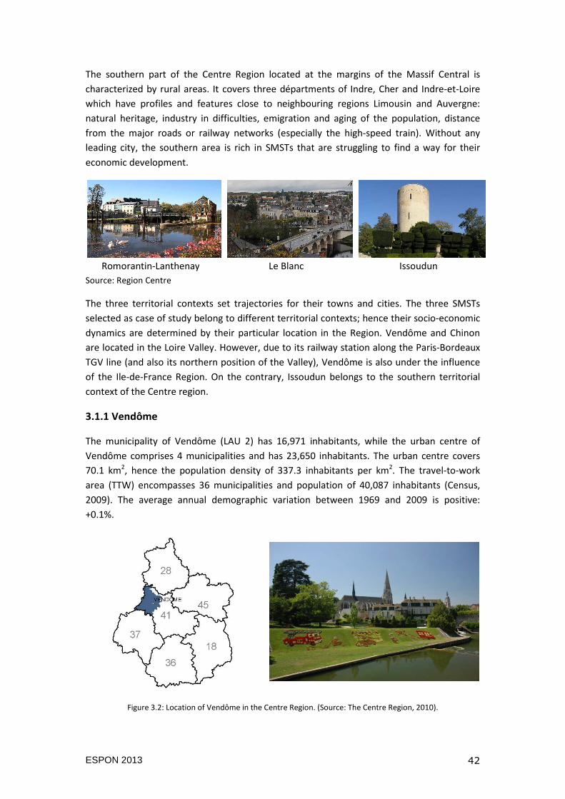
ESPON 2013 42
The southern part of the Centre Region located at the margins of the Massif Central is
characterized by rural areas. It covers three départments of Indre, Cher and Indre-et-Loire
which have profiles and features close to neighbouring regions Limousin and Auvergne:
natural heritage, industry in difficulties, emigration and aging of the population, distance
from the major roads or railway networks (especially the high-speed train). Without any
leading city, the southern area is rich in SMSTs that are struggling to find a way for their
economic development.
Romorantin-Lanthenay Le Blanc Issoudun
Source: Region Centre
The three territorial contexts set trajectories for their towns and cities. The three SMSTs
selected as case of study belong to different territorial contexts; hence their socio-economic
dynamics are determined by their particular location in the Region. Vendôme and Chinon
are located in the Loire Valley. However, due to its railway station along the Paris-Bordeaux
TGV line (and also its northern position of the Valley), Vendôme is also under the influence
of the Ile-de-France Region. On the contrary, Issoudun belongs to the southern territorial
context of the Centre region.
3.1.1 Vendôme
The municipality of Vendôme (LAU 2) has 16,971 inhabitants, while the urban centre of
Vendôme comprises 4 municipalities and has 23,650 inhabitants. The urban centre covers
70.1 km2, hence the population density of 337.3 inhabitants per km2. The travel-to-work
area (TTW) encompasses 36 municipalities and population of 40,087 inhabitants (Census,
2009). The average annual demographic variation between 1969 and 2009 is positive:
+0.1%.
Figure 3.2: Location of Vendôme in the Centre Region. (Source: The Centre Region, 2010).
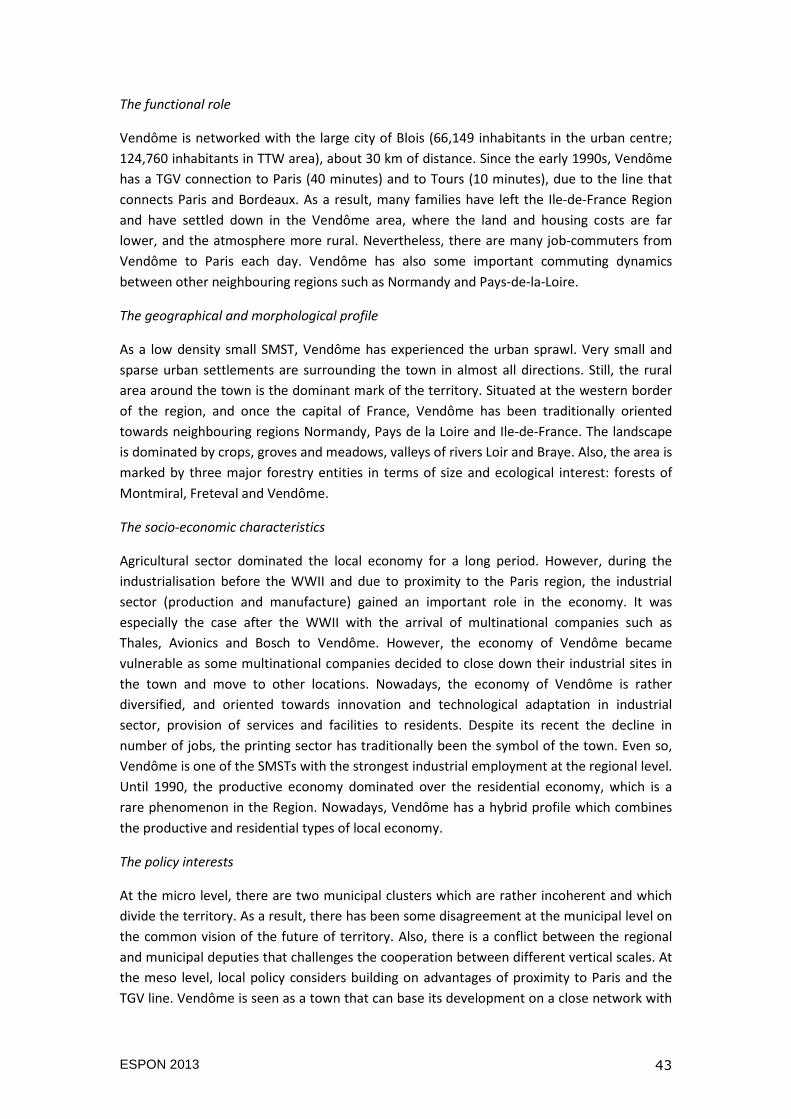
ESPON 2013 43
The functional role
Vendôme is networked with the large city of Blois (66,149 inhabitants in the urban centre;
124,760 inhabitants in TTW area), about 30 km of distance. Since the early 1990s, Vendôme
has a TGV connection to Paris (40 minutes) and to Tours (10 minutes), due to the line that
connects Paris and Bordeaux. As a result, many families have left the Ile-de-France Region
and have settled down in the Vendôme area, where the land and housing costs are far
lower, and the atmosphere more rural. Nevertheless, there are many job-commuters from
Vendôme to Paris each day. Vendôme has also some important commuting dynamics
between other neighbouring regions such as Normandy and Pays-de-la-Loire.
The geographical and morphological profile
As a low density small SMST, Vendôme has experienced the urban sprawl. Very small and
sparse urban settlements are surrounding the town in almost all directions. Still, the rural
area around the town is the dominant mark of the territory. Situated at the western border
of the region, and once the capital of France, Vendôme has been traditionally oriented
towards neighbouring regions Normandy, Pays de la Loire and Ile-de-France. The landscape
is dominated by crops, groves and meadows, valleys of rivers Loir and Braye. Also, the area is
marked by three major forestry entities in terms of size and ecological interest: forests of
Montmiral, Freteval and Vendôme.
The socio-economic characteristics
Agricultural sector dominated the local economy for a long period. However, during the
industrialisation before the WWII and due to proximity to the Paris region, the industrial
sector (production and manufacture) gained an important role in the economy. It was
especially the case after the WWII with the arrival of multinational companies such as
Thales, Avionics and Bosch to Vendôme. However, the economy of Vendôme became
vulnerable as some multinational companies decided to close down their industrial sites in
the town and move to other locations. Nowadays, the economy of Vendôme is rather
diversified, and oriented towards innovation and technological adaptation in industrial
sector, provision of services and facilities to residents. Despite its recent the decline in
number of jobs, the printing sector has traditionally been the symbol of the town. Even so,
Vendôme is one of the SMSTs with the strongest industrial employment at the regional level.
Until 1990, the productive economy dominated over the residential economy, which is a
rare phenomenon in the Region. Nowadays, Vendôme has a hybrid profile which combines
the productive and residential types of local economy.
The policy interests
At the micro level, there are two municipal clusters which are rather incoherent and which
divide the territory. As a result, there has been some disagreement at the municipal level on
the common vision of the future of territory. Also, there is a conflict between the regional
and municipal deputies that challenges the cooperation between different vertical scales. At
the meso level, local policy considers building on advantages of proximity to Paris and the
TGV line. Vendôme is seen as a town that can base its development on a close network with
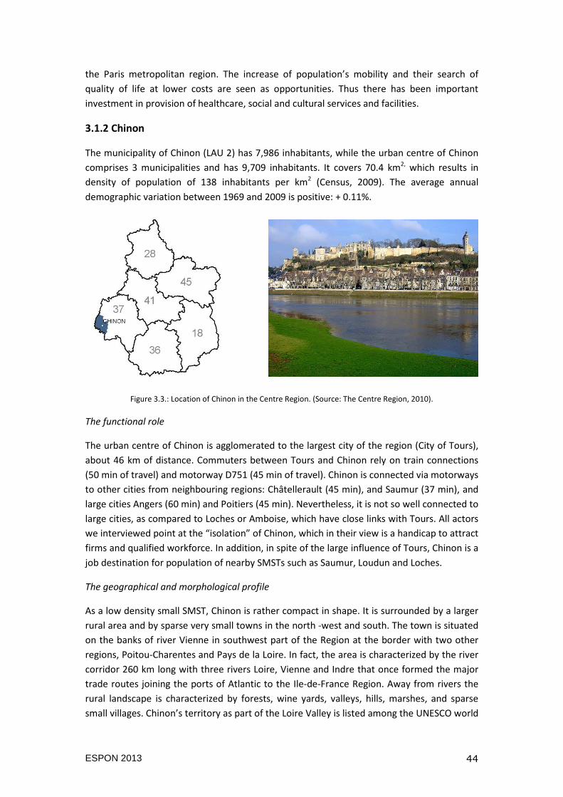
ESPON 2013 44
the Paris metropolitan region. The increase of population’s mobility and their search of
quality of life at lower costs are seen as opportunities. Thus there has been important
investment in provision of healthcare, social and cultural services and facilities.
3.1.2 Chinon
The municipality of Chinon (LAU 2) has 7,986 inhabitants, while the urban centre of Chinon
comprises 3 municipalities and has 9,709 inhabitants. It covers 70.4 km2, which results in
density of population of 138 inhabitants per km2 (Census, 2009). The average annual
demographic variation between 1969 and 2009 is positive: + 0.11%.
Figure 3.3.: Location of Chinon in the Centre Region. (Source: The Centre Region, 2010).
The functional role
The urban centre of Chinon is agglomerated to the largest city of the region (City of Tours),
about 46 km of distance. Commuters between Tours and Chinon rely on train connections
(50 min of travel) and motorway D751 (45 min of travel). Chinon is connected via motorways
to other cities from neighbouring regions: Châtellerault (45 min), and Saumur (37 min), and
large cities Angers (60 min) and Poitiers (45 min). Nevertheless, it is not so well connected to
large cities, as compared to Loches or Amboise, which have close links with Tours. All actors
we interviewed point at the “isolation” of Chinon, which in their view is a handicap to attract
firms and qualified workforce. In addition, in spite of the large influence of Tours, Chinon is a
job destination for population of nearby SMSTs such as Saumur, Loudun and Loches.
The geographical and morphological profile
As a low density small SMST, Chinon is rather compact in shape. It is surrounded by a larger
rural area and by sparse very small towns in the north -west and south. The town is situated
on the banks of river Vienne in southwest part of the Region at the border with two other
regions, Poitou-Charentes and Pays de la Loire. In fact, the area is characterized by the river
corridor 260 km long with three rivers Loire, Vienne and Indre that once formed the major
trade routes joining the ports of Atlantic to the Ile-de-France Region. Away from rivers the
rural landscape is characterized by forests, wine yards, valleys, hills, marshes, and sparse
small villages. Chinon’s territory as part of the Loire Valley is listed among the UNESCO world
ESPON 2013 45
heritage, which was the initiative of its former mayor Yves Dauge (also a co-founder of the
Association of Small Towns of France). Since 1996, there is also the Natural Regional Park
Loire-Anjou-Touraine, which extends to the neighbouring Pays de la Loire region.
The socio-economic characteristics
The town has seen the increase of services after the implantation of the nuclear plant in a
neighbouring municipality of Avoine, which in turn has affected the development of other
relating sectors. The nuclear plant is the most important generator of employment
(providing directly about 1 300 jobs) Also, there is a strong touristic sector that relies on
existing natural, cultural and built amenities of Chinon itself and of its wider territory. A
branch of the University of Tours has been in Chinon since the 1990s and provides
vocational training in water management. In addition, there is a significant percentage of
agricultural space. It also has the reputation as cultural town rich in heritage, history and
wine. Besides Tours, the employment zone of Chinon has been one of the most dynamic in
terms of job creation in the Indre-et-Loire Department. More in particular, Chinon has a role
of service provider for its territory. Regarding the profile of economy, it has a combination of
all three types: productive, residential and creative.
The policy interests
At the micro level, Chinon faces challenges regarding the polarisation and competition
between richer and poorer municipalities. Thus, the policy interest is to promote larger
scale: life basin that would encompass more rural and urban municipalities. The current size
of Chinon’s cluster of municipalities is seen as too small and inefficient, thus under the
framework of the ongoing territorial reform, it is planned to merge it with two other
municipal clusters. At the meso level, Chinon is considered as a town open to other regions
due to its particular location at the border of the region. Local dynamics, especially
commuting flow as we showed in the previous chapter highlights the presence of networks
between cities of different regions. Thus, there is an interest to reinforce the social, cultural
and economic relations with neighbouring cities: Loudun, Thouars, Châtellerault and
Saumur. Local policies also are concentrated on provision of services and on improving the
quality of life in order to face the demographic decline and to attract new residents. Even so,
the town is not as accessible as other SMSTs under the same influence of Tours such as
Amboise and Loches, hence the local authorities face greater challenges.
3.1.3 Issoudun
The municipality of Issoudun (LAU 2) has 13,230 inhabitants. It is also the only municipality
within the urban centre of Issoudun. It covers 36.6 km2, which results in density of
population of 361.5 inhabitants per km2, which is a rather high density compared to other
SMSTs in the Region. The travel-to-work area encompasses 11 municipalities and has 17,750
inhabitants (Census, 2009). The average annual demographic variation between 1969 and
2009 is negative: - 0.27%. Issoudun is situated in the south of the Region, which in general
faces the challenge of a decrease in population.
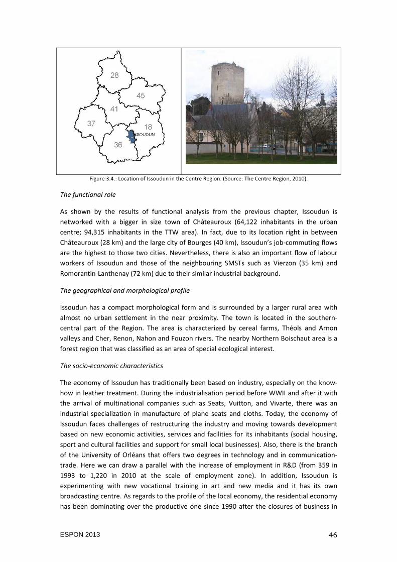
ESPON 2013 46
Figure 3.4.: Location of Issoudun in the Centre Region. (Source: The Centre Region, 2010).
The functional role
As shown by the results of functional analysis from the previous chapter, Issoudun is
networked with a bigger in size town of Châteauroux (64,122 inhabitants in the urban
centre; 94,315 inhabitants in the TTW area). In fact, due to its location right in between
Châteauroux (28 km) and the large city of Bourges (40 km), Issoudun’s job-commuting flows
are the highest to those two cities. Nevertheless, there is also an important flow of labour
workers of Issoudun and those of the neighbouring SMSTs such as Vierzon (35 km) and
Romorantin-Lanthenay (72 km) due to their similar industrial background.
The geographical and morphological profile
Issoudun has a compact morphological form and is surrounded by a larger rural area with
almost no urban settlement in the near proximity. The town is located in the southern-
central part of the Region. The area is characterized by cereal farms, Théols and Arnon
valleys and Cher, Renon, Nahon and Fouzon rivers. The nearby Northern Boischaut area is a
forest region that was classified as an area of special ecological interest.
The socio-economic characteristics
The economy of Issoudun has traditionally been based on industry, especially on the know-
how in leather treatment. During the industrialisation period before WWII and after it with
the arrival of multinational companies such as Seats, Vuitton, and Vivarte, there was an
industrial specialization in manufacture of plane seats and cloths. Today, the economy of
Issoudun faces challenges of restructuring the industry and moving towards development
based on new economic activities, services and facilities for its inhabitants (social housing,
sport and cultural facilities and support for small local businesses). Also, there is the branch
of the University of Orléans that offers two degrees in technology and in communication-
trade. Here we can draw a parallel with the increase of employment in R&D (from 359 in
1993 to 1,220 in 2010 at the scale of employment zone). In addition, Issoudun is
experimenting with new vocational training in art and new media and it has its own
broadcasting centre. As regards to the profile of the local economy, the residential economy
has been dominating over the productive one since 1990 after the closures of business in
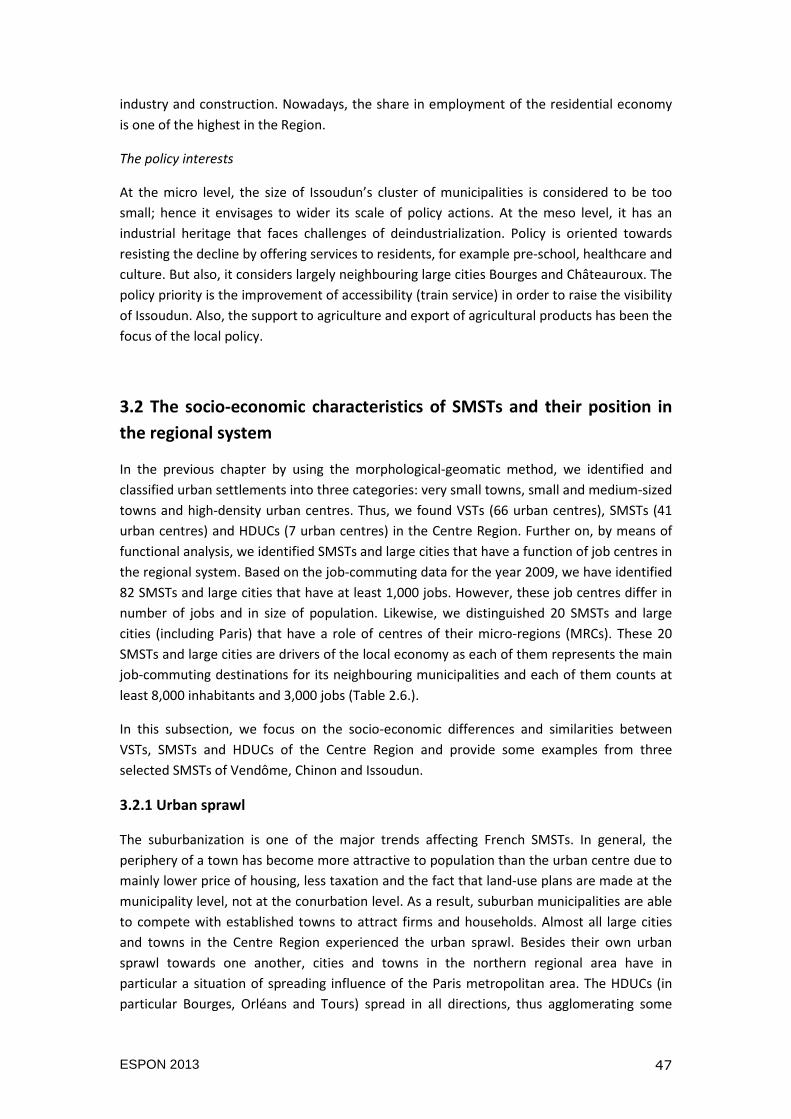
ESPON 2013 47
industry and construction. Nowadays, the share in employment of the residential economy
is one of the highest in the Region.
The policy interests
At the micro level, the size of Issoudun’s cluster of municipalities is considered to be too
small; hence it envisages to wider its scale of policy actions. At the meso level, it has an
industrial heritage that faces challenges of deindustrialization. Policy is oriented towards
resisting the decline by offering services to residents, for example pre-school, healthcare and
culture. But also, it considers largely neighbouring large cities Bourges and Châteauroux. The
policy priority is the improvement of accessibility (train service) in order to raise the visibility
of Issoudun. Also, the support to agriculture and export of agricultural products has been the
focus of the local policy.
3.2 The socio-economic characteristics of SMSTs and their position in
the regional system
In the previous chapter by using the morphological-geomatic method, we identified and
classified urban settlements into three categories: very small towns, small and medium-sized
towns and high-density urban centres. Thus, we found VSTs (66 urban centres), SMSTs (41
urban centres) and HDUCs (7 urban centres) in the Centre Region. Further on, by means of
functional analysis, we identified SMSTs and large cities that have a function of job centres in
the regional system. Based on the job-commuting data for the year 2009, we have identified
82 SMSTs and large cities that have at least 1,000 jobs. However, these job centres differ in
number of jobs and in size of population. Likewise, we distinguished 20 SMSTs and large
cities (including Paris) that have a role of centres of their micro-regions (MRCs). These 20
SMSTs and large cities are drivers of the local economy as each of them represents the main
job-commuting destinations for its neighbouring municipalities and each of them counts at
least 8,000 inhabitants and 3,000 jobs (Table 2.6.).
In this subsection, we focus on the socio-economic differences and similarities between
VSTs, SMSTs and HDUCs of the Centre Region and provide some examples from three
selected SMSTs of Vendôme, Chinon and Issoudun.
3.2.1 Urban sprawl
The suburbanization is one of the major trends affecting French SMSTs. In general, the
periphery of a town has become more attractive to population than the urban centre due to
mainly lower price of housing, less taxation and the fact that land-use plans are made at the
municipality level, not at the conurbation level. As a result, suburban municipalities are able
to compete with established towns to attract firms and households. Almost all large cities
and towns in the Centre Region experienced the urban sprawl. Besides their own urban
sprawl towards one another, cities and towns in the northern regional area have in
particular a situation of spreading influence of the Paris metropolitan area. The HDUCs (in
particular Bourges, Orléans and Tours) spread in all directions, thus agglomerating some
ESPON 2013 48
neighbouring VSTs and SMSTs into their outer-rings (i.e. the case of Amboise that got
agglomerated to Tours). Concerning SMSTs, they stabilised their outer-ring over the last 20
years and have been experiencing less intense urban sprawl. On the other side, after a long
period of population decreased prior to the 1990s, VSTs and rural areas regained population,
especially those located in the Loire valley.
Average growth rate of the population between 1990 and 2009
Municipal centre Urban centre Travel-to-work area
- 3.8% - 2 % + 1.4 %
Figure 3.5: Average growth rate of the population between 1990 and 2009 in urban centres (fr.unités urbaines)
and travel-to-work areas (fr.aires urbaines) in the Centre Region. (Source: INSEE, 2009).
Figure 3.5. shows the change in growth rate in population of large cities and SMSTs in the
Centre Region by comparing different spatial scales. We observe the trend of average SMSTs
and city centres loosing the population in favour of peripheral areas. Nevertheless, there are
some differences. Firstly, large cities such as Tours, Orléans and Chartres located in the Loire
Valley and in the northern area of the Region continue to gain the population in both centre
and periphery. However, they also experience the highest sprawl on their outer rings. On the
other hand, SMSTs especially those located in the southern area such as Châteauroux,
Vierzon and Romorantin-Lanthenay experience the negative movement of population from
centres towards periphery.
Unlike Issoudun that shrank over the last 50 years by losing the population in both the
centre and the periphery, Chinon and Vendôme saw an increase in population. The average
population variation rate for the period 1968-2008 for Issoudun was negative (-0.27% for the
urban centre; -0.11% for the TTW area). It was positive for Chinon (+0.26% for the urban
ESPON 2013 49
centre, +0.30% for the TTW area) and for Vendôme (+0.5% for the urban centre, +0.3% for
the TTW area). As presented in the second chapter, the proximity of Tours has been
particularly affecting Chinon for which large city of Tours is the main job-commuting
destination. Due to its location in the northern part of the Region and the TGV line,
Vendôme has been split under the influence of Paris metropolitan area and the large city of
Blois.
3.2.2 Demographic structure
Population age
Over the last 10 years, France as well as the Centre Region has had an increase in population
over 60 years old, and a decrease in number of population under 20 years old. In 2009, the
population category of 65+ years old represented 25% of total regional population
compared to 23% in 1999. Respectively, the population under 20 years old represented 24%
of the total population in the Region compared to 26% in 1999. However, there are
differences between types of settlements and their territorial context. Firstly, SMSTs and
VSTs of the Centre Region had a higher average increase in population 65+ than HDUCs. As
shown in Figure 3.5., the highest dependency ratio in 2005 was observed in the employment
of SMSTs (more seniors per 100 youngsters). Secondly, SMSTs and VSTs located in the
southern part of the Region saw the highest growth in number in population category 65+.
The dependency ratio of southern SMSTs overpassed 150 seniors per 100 youngsters (Figure
3.6.).
Vendôme, Issoudun and Chinon are experiencing the same trend as other regional SMSTs.
Their population over 65 years old has increased since 1999 by 2% per year in average, while
the population category 15-29 years old has decreased by 2% per year in average. While in
2005, the regional average dependency ratio was 94, all three selected SMSTs had
dependency ratio above regional average: Chinon had 111 seniors per 100 youngsters;
Vendôme 124 seniors per 100 youngsters; and Issoudun 129 seniors per 100 youngsters.
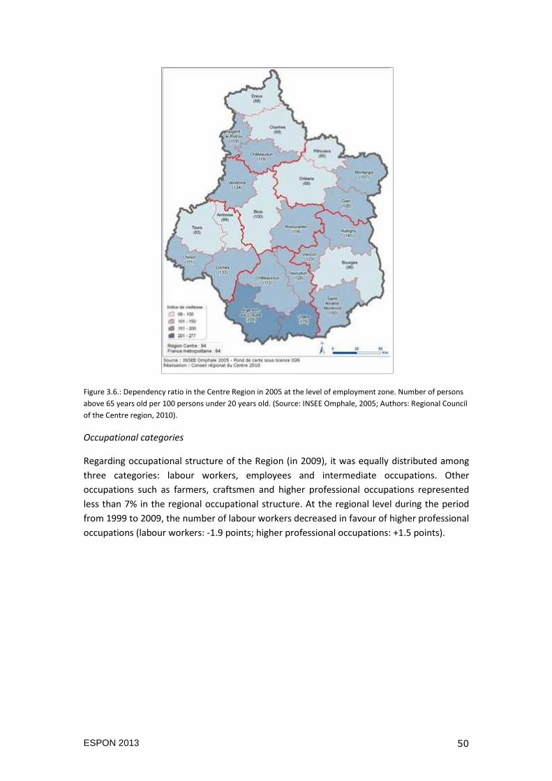
ESPON 2013 50
Figure 3.6.: Dependency ratio in the Centre Region in 2005 at the level of employment zone. Number of persons
above 65 years old per 100 persons under 20 years old. (Source: INSEE Omphale, 2005; Authors: Regional Council
of the Centre region, 2010).
Occupational categories
Regarding occupational structure of the Region (in 2009), it was equally distributed among
three categories: labour workers, employees and intermediate occupations. Other
occupations such as farmers, craftsmen and higher professional occupations represented
less than 7% in the regional occupational structure. At the regional level during the period
from 1999 to 2009, the number of labour workers decreased in favour of higher professional
occupations (labour workers: -1.9 points; higher professional occupations: +1.5 points).
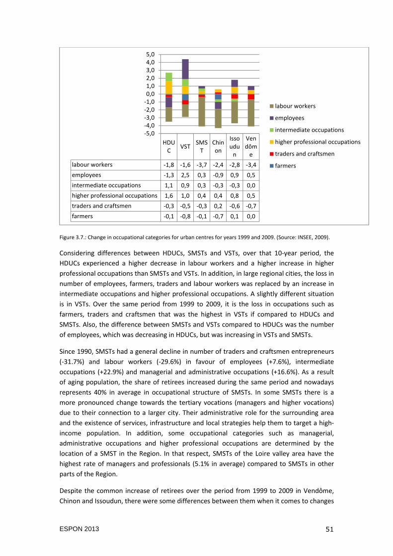
ESPON 2013 51
Figure 3.7.: Change in occupational categories for urban centres for years 1999 and 2009. (Source: INSEE, 2009).
Considering differences between HDUCs, SMSTs and VSTs, over that 10-year period, the
HDUCs experienced a higher decrease in labour workers and a higher increase in higher
professional occupations than SMSTs and VSTs. In addition, in large regional cities, the loss in
number of employees, farmers, traders and labour workers was replaced by an increase in
intermediate occupations and higher professional occupations. A slightly different situation
is in VSTs. Over the same period from 1999 to 2009, it is the loss in occupations such as
farmers, traders and craftsmen that was the highest in VSTs if compared to HDUCs and
SMSTs. Also, the difference between SMSTs and VSTs compared to HDUCs was the number
of employees, which was decreasing in HDUCs, but was increasing in VSTs and SMSTs.
Since 1990, SMSTs had a general decline in number of traders and craftsmen entrepreneurs
(-31.7%) and labour workers (-29.6%) in favour of employees (+7.6%), intermediate
occupations (+22.9%) and managerial and administrative occupations (+16.6%). As a result
of aging population, the share of retirees increased during the same period and nowadays
represents 40% in average in occupational structure of SMSTs. In some SMSTs there is a
more pronounced change towards the tertiary vocations (managers and higher vocations)
due to their connection to a larger city. Their administrative role for the surrounding area
and the existence of services, infrastructure and local strategies help them to target a high-
income population. In addition, some occupational categories such as managerial,
administrative occupations and higher professional occupations are determined by the
location of a SMST in the Region. In that respect, SMSTs of the Loire valley area have the
highest rate of managers and professionals (5.1% in average) compared to SMSTs in other
parts of the Region.
Despite the common increase of retirees over the period from 1999 to 2009 in Vendôme,
Chinon and Issoudun, there were some differences between them when it comes to changes
HDUC
VSTSMS
TChinon
Issoudu
n
Vendôm
e
labour workers -1,8 -1,6 -3,7 -2,4 -2,8 -3,4
employees -1,3 2,5 0,3 -0,9 0,9 0,5
intermediate occupations 1,1 0,9 0,3 -0,3 -0,3 0,0
higher professional occupations 1,6 1,0 0,4 0,4 0,8 0,5
traders and craftsmen -0,3 -0,5 -0,3 0,2 -0,6 -0,7
farmers -0,1 -0,8 -0,1 -0,7 0,1 0,0
-5,0-4,0-3,0-2,0-1,00,01,02,03,04,05,0
labour workers
employees
intermediate occupations
higher professional occupations
traders and craftsmen
farmers
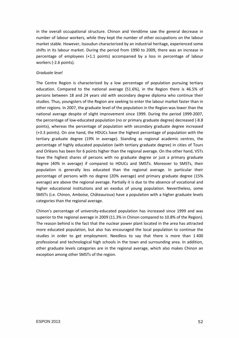
ESPON 2013 52
in the overall occupational structure. Chinon and Vendôme saw the general decrease in
number of labour workers, while they kept the number of other occupations on the labour
market stable. However, Issoudun characterized by an industrial heritage, experienced some
shifts in its labour market. During the period from 1990 to 2009, there was an increase in
percentage of employees (+1.1 points) accompanied by a loss in percentage of labour
workers (-2.6 points).
Graduate level
The Centre Region is characterized by a low percentage of population pursuing tertiary
education. Compared to the national average (51.6%), in the Region there is 46.5% of
persons between 18 and 24 years old with secondary degree diploma who continue their
studies. Thus, youngsters of the Region are seeking to enter the labour market faster than in
other regions. In 2007, the graduate level of the population in the Region was lower than the
national average despite of slight improvement since 1999. During the period 1999-2007,
the percentage of low-educated population (no or primary graduate degree) decreased (-8.8
points), whereas the percentage of population with secondary graduate degree increased
(+3.3 points). On one hand, the HDUCs have the highest percentage of population with the
tertiary graduate degree (19% in average). Standing as regional academic centres, the
percentage of highly educated population (with tertiary graduate degree) in cities of Tours
and Orléans has been for 6 points higher than the regional average. On the other hand, VSTs
have the highest shares of persons with no graduate degree or just a primary graduate
degree (40% in average) if compared to HDUCs and SMSTs. Moreover to SMSTs, their
population is generally less educated than the regional average. In particular their
percentage of persons with no degree (20% average) and primary graduate degree (15%
average) are above the regional average. Partially it is due to the absence of vocational and
higher educational institutions and an exodus of young population. Nevertheless, some
SMSTs (i.e. Chinon, Amboise, Châteauroux) have a population with a higher graduate levels
categories than the regional average.
Chinon’s percentage of university-educated population has increased since 1999 and was
superior to the regional average in 2009 (11.3% in Chinon compared to 10.8% of the Region).
The reason behind is the fact that the nuclear power plant located in the area has attracted
more educated population, but also has encouraged the local population to continue the
studies in order to get employment. Needless to say that there is more than 1 400
professional and technological high schools in the town and surrounding area. In addition,
other graduate levels categories are in the regional average, which also makes Chinon an
exception among other SMSTs of the region.
ESPON 2013 53
Figure 3.8: Graduate levels of the population 15+ years old in employment zones of the Centre Region in 2007.
(Source: INSEE; Authors: Regional Council of the Centre region, 2010).
3.2.3 Housing
At the regional level, the housing stock increased by 8.6% from 1999 to 2009. Nevertheless,
occupied dwellings decreased by 0.7 points in favour of unoccupied dwellings. The share of
occupied dwellings in the housing stock differs depending on the type of urban settlements
(but also in the territorial location of the urban centre in the Region). The HDUCs have less
unoccupied dwellings than SMSTs and VSTs (7.6% in average). On the contrary, VSTs have
the highest percentage of unoccupied dwellings in their housing stock, which is 11.9% in
average. When it comes to SMSTs, their percentage of unoccupied dwellings is above the
regional average (10.6% compared to regional 7.9%). Nevertheless, there are differences in
occupations related to territorial contexts (fr. plaques territoriales). SMSTs located in the
southern part of the Region record higher percentage of vacant dwellings.
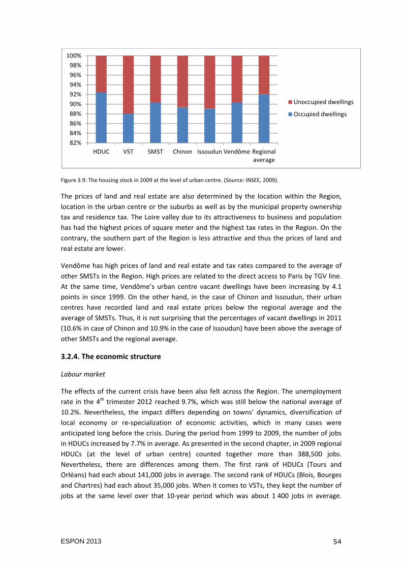
ESPON 2013 54
Figure 3.9: The housing stock in 2009 at the level of urban centre. (Source: INSEE, 2009).
The prices of land and real estate are also determined by the location within the Region,
location in the urban centre or the suburbs as well as by the municipal property ownership
tax and residence tax. The Loire valley due to its attractiveness to business and population
has had the highest prices of square meter and the highest tax rates in the Region. On the
contrary, the southern part of the Region is less attractive and thus the prices of land and
real estate are lower.
Vendôme has high prices of land and real estate and tax rates compared to the average of
other SMSTs in the Region. High prices are related to the direct access to Paris by TGV line.
At the same time, Vendôme’s urban centre vacant dwellings have been increasing by 4.1
points in since 1999. On the other hand, in the case of Chinon and Issoudun, their urban
centres have recorded land and real estate prices below the regional average and the
average of SMSTs. Thus, it is not surprising that the percentages of vacant dwellings in 2011
(10.6% in case of Chinon and 10.9% in the case of Issoudun) have been above the average of
other SMSTs and the regional average.
3.2.4. The economic structure
Labour market
The effects of the current crisis have been also felt across the Region. The unemployment
rate in the 4th trimester 2012 reached 9.7%, which was still below the national average of
10.2%. Nevertheless, the impact differs depending on towns’ dynamics, diversification of
local economy or re-specialization of economic activities, which in many cases were
anticipated long before the crisis. During the period from 1999 to 2009, the number of jobs
in HDUCs increased by 7.7% in average. As presented in the second chapter, in 2009 regional
HDUCs (at the level of urban centre) counted together more than 388,500 jobs.
Nevertheless, there are differences among them. The first rank of HDUCs (Tours and
Orléans) had each about 141,000 jobs in average. The second rank of HDUCs (Blois, Bourges
and Chartres) had each about 35,000 jobs. When it comes to VSTs, they kept the number of
jobs at the same level over that 10-year period which was about 1 400 jobs in average.
82%
84%
86%
88%
90%
92%
94%
96%
98%
100%
HDUC VST SMST Chinon Issoudun Vendôme Regionalaverage
Unoccupied dwellings
Occupied dwellings
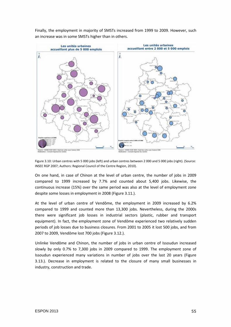
ESPON 2013 55
Finally, the employment in majority of SMSTs increased from 1999 to 2009. However, such
an increase was in some SMSTs higher than in others.
Figure 3.10: Urban centres with 5 000 jobs (left) and urban centres between 2 000 and 5 000 jobs (right). (Source:
INSEE RGP 2007; Authors: Regional Council of the Centre Region, 2010).
On one hand, in case of Chinon at the level of urban centre, the number of jobs in 2009
compared to 1999 increased by 7.7% and counted about 5,400 jobs. Likewise, the
continuous increase (15%) over the same period was also at the level of employment zone
despite some losses in employment in 2008 (Figure 3.11.).
At the level of urban centre of Vendôme, the employment in 2009 increased by 6.2%
compared to 1999 and counted more than 13,300 jobs. Nevertheless, during the 2000s
there were significant job losses in industrial sectors (plastic, rubber and transport
equipment). In fact, the employment zone of Vendôme experienced two relatively sudden
periods of job losses due to business closures. From 2001 to 2005 it lost 500 jobs, and from
2007 to 2009, Vendôme lost 700 jobs (Figure 3.12.).
Unlinke Vendôme and Chinon, the number of jobs in urban centre of Issoudun increased
slowly by only 0.7% to 7,300 jobs in 2009 compared to 1999. The employment zone of
Issoudun experienced many variations in number of jobs over the last 20 years (Figure
3.13.). Decrease in employment is related to the closure of many small businesses in
industry, construction and trade.
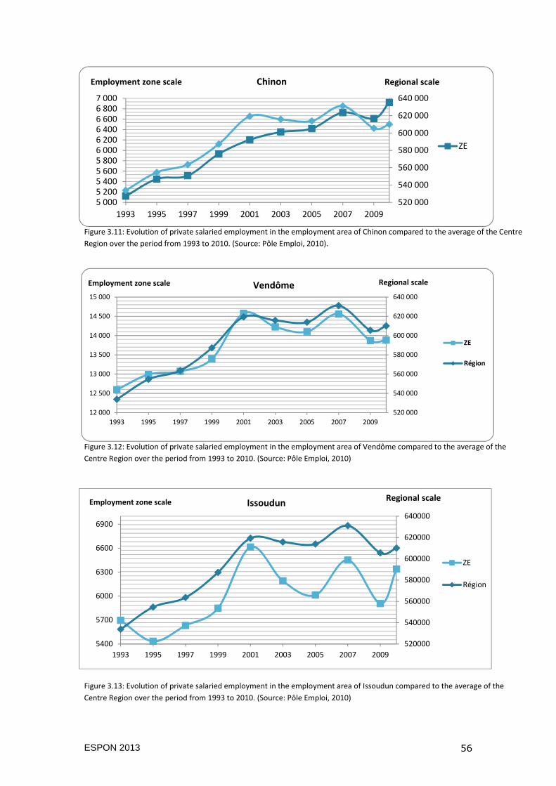
ESPON 2013 56
520000
540000
560000
580000
600000
620000
640000
5400
5700
6000
6300
6600
6900
1993 1995 1997 1999 2001 2003 2005 2007 2009
ZE
Région
Employment zone scaleRegional scale
Issoudun
Figure 3.11: Evolution of private salaried employment in the employment area of Chinon compared to the average of the Centre
Region over the period from 1993 to 2010. (Source: Pôle Emploi, 2010).
Figure 3.12: Evolution of private salaried employment in the employment area of Vendôme compared to the average of the
Centre Region over the period from 1993 to 2010. (Source: Pôle Emploi, 2010)
Figure 3.13: Evolution of private salaried employment in the employment area of Issoudun compared to the average of the
Centre Region over the period from 1993 to 2010. (Source: Pôle Emploi, 2010)
520 000
540 000
560 000
580 000
600 000
620 000
640 000
5 0005 2005 4005 6005 8006 0006 2006 4006 6006 8007 000
1993 1995 1997 1999 2001 2003 2005 2007 2009
ZE
Employment zone scale Regional scaleChinon
520 000
540 000
560 000
580 000
600 000
620 000
640 000
12 000
12 500
13 000
13 500
14 000
14 500
15 000
1993 1995 1997 1999 2001 2003 2005 2007 2009
ZE
Région
Employment zone scale Regional scaleVendôme
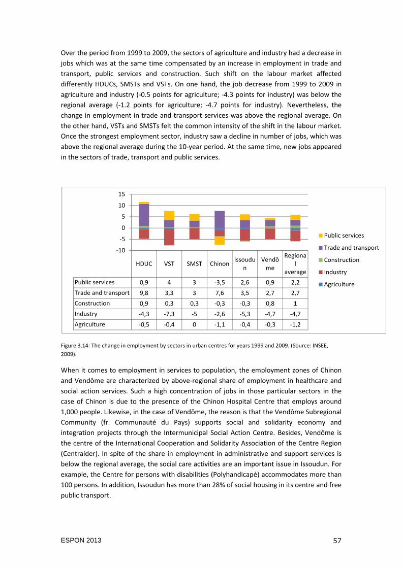
ESPON 2013 57
Over the period from 1999 to 2009, the sectors of agriculture and industry had a decrease in
jobs which was at the same time compensated by an increase in employment in trade and
transport, public services and construction. Such shift on the labour market affected
differently HDUCs, SMSTs and VSTs. On one hand, the job decrease from 1999 to 2009 in
agriculture and industry (-0.5 points for agriculture; -4.3 points for industry) was below the
regional average (-1.2 points for agriculture; -4.7 points for industry). Nevertheless, the
change in employment in trade and transport services was above the regional average. On
the other hand, VSTs and SMSTs felt the common intensity of the shift in the labour market.
Once the strongest employment sector, industry saw a decline in number of jobs, which was
above the regional average during the 10-year period. At the same time, new jobs appeared
in the sectors of trade, transport and public services.
Figure 3.14: The change in employment by sectors in urban centres for years 1999 and 2009. (Source: INSEE,
2009).
When it comes to employment in services to population, the employment zones of Chinon
and Vendôme are characterized by above-regional share of employment in healthcare and
social action services. Such a high concentration of jobs in those particular sectors in the
case of Chinon is due to the presence of the Chinon Hospital Centre that employs around
1,000 people. Likewise, in the case of Vendôme, the reason is that the Vendôme Subregional
Community (fr. Communauté du Pays) supports social and solidarity economy and
integration projects through the Intermunicipal Social Action Centre. Besides, Vendôme is
the centre of the International Cooperation and Solidarity Association of the Centre Region
(Centraider). In spite of the share in employment in administrative and support services is
below the regional average, the social care activities are an important issue in Issoudun. For
example, the Centre for persons with disabilities (Polyhandicapé) accommodates more than
100 persons. In addition, Issoudun has more than 28% of social housing in its centre and free
public transport.
HDUC VST SMST ChinonIssoudu
nVendô
me
Regional
average
Public services 0,9 4 3 -3,5 2,6 0,9 2,2
Trade and transport 9,8 3,3 3 7,6 3,5 2,7 2,7
Construction 0,9 0,3 0,3 -0,3 -0,3 0,8 1
Industry -4,3 -7,3 -5 -2,6 -5,3 -4,7 -4,7
Agriculture -0,5 -0,4 0 -1,1 -0,4 -0,3 -1,2
-10
-5
0
5
10
15
Public services
Trade and transport
Construction
Industry
Agriculture
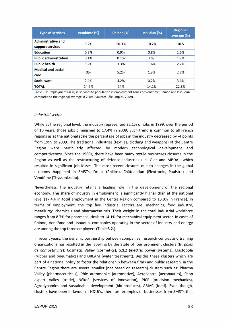
ESPON 2013 58
Type of services Vendôme (%) Chinon (%) Issoudun (%) Regional
average (%)
Administrative and
support services 5.2% 10.3% 10.2% 10.5
Education 0.8% 0.9% 0.8% 1.6%
Public administration 0.1% 0.1% 0% 1.7%
Public health 3.2% 3.3% 1.6% 2.7%
Medical and social
care 3% 5.2% 1.3% 2.7%
Social work 2.4% 4.2% 0.2% 3.6%
TOTAL 14.7% 24% 14.1% 22.8%
Table 3.1: Employment (in %) in services to population in employment zones of Vendôme, Chinon and Issoudun
compared to the regional average in 2009. (Source: Pôle Emploi, 2009).
Industrial sector
While at the regional level, the industry represented 22.1% of jobs in 1999, over the period
of 10 years, those jobs diminished to 17.4% in 2009. Such trend is common to all French
regions as at the national scale the percentage of jobs in the industry decreased by -4 points
from 1999 to 2009. The traditional industries (textiles, clothing and weapons) of the Centre
Region were particularly affected by modern technological development and
competitiveness. Since the 1960s, there have been many textile businesses closures in the
Region as well as the restructuring of defence industries (i.e. Giat and MBDA), which
resulted in significant job losses. The most recent closures due to changes in the global
economy happened in SMSTs: Dreux (Philips), Châteaudun (Flextronic, Paulstra) and
Vendôme (Thyssenkrupp).
Nevertheless, the industry retains a leading role in the development of the regional
economy. The share of industry in employment is significantly higher than at the national
level (17.4% in total employment in the Centre Region compared to 13.9% in France). In
terms of employment, the top five industrial sectors are: mechanics, food industry,
metallurgy, chemicals and pharmaceuticals. Their weight in the total industrial workforce
ranges from 8.7% for pharmaceuticals to 14.1% for mechanical equipment sector. In cases of
Chinon, Vendôme and Issoudun, companies operating in the sector of industry and energy
are among the top three employers (Table 3.2.).
In recent years, the dynamic partnership between companies, research centres and training
organizations has resulted in the labelling by the State of four prominent clusters (fr. pôles
de compétitivité): Cosmetic Valley (cosmetics), S2E2 (electric power systems), Elastopole
(rubber and pneumatics) and DREAM (water treatment). Besides these clusters which are
part of a national policy to foster the relationship between firms and public research, in the
Centre Region there are several smaller (not based on research) clusters such as: Pharma
Valley (pharmaceuticals), Pôle automobile (automotive), Aérocentre (aeronautics), Shop
expert Valley (trade), Nékoé (services of innovation), PICF (precision mechanics),
Agrodynamics and sustainable development (bio-products), ARIAC (food). Even though,
clusters have been in favour of HDUCs, there are examples of businesses from SMSTs that
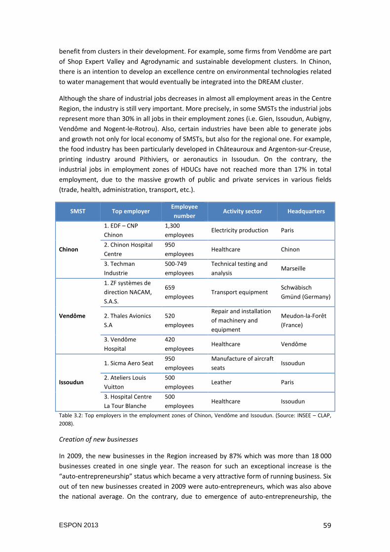
ESPON 2013 59
benefit from clusters in their development. For example, some firms from Vendôme are part
of Shop Expert Valley and Agrodynamic and sustainable development clusters. In Chinon,
there is an intention to develop an excellence centre on environmental technologies related
to water management that would eventually be integrated into the DREAM cluster.
Although the share of industrial jobs decreases in almost all employment areas in the Centre
Region, the industry is still very important. More precisely, in some SMSTs the industrial jobs
represent more than 30% in all jobs in their employment zones (i.e. Gien, Issoudun, Aubigny,
Vendôme and Nogent-le-Rotrou). Also, certain industries have been able to generate jobs
and growth not only for local economy of SMSTs, but also for the regional one. For example,
the food industry has been particularly developed in Châteauroux and Argenton-sur-Creuse,
printing industry around Pithiviers, or aeronautics in Issoudun. On the contrary, the
industrial jobs in employment zones of HDUCs have not reached more than 17% in total
employment, due to the massive growth of public and private services in various fields
(trade, health, administration, transport, etc.).
SMST Top employer Employee
number Activity sector Headquarters
Chinon
1. EDF – CNP
Chinon
1,300
employees Electricity production Paris
2. Chinon Hospital
Centre
950
employees Healthcare Chinon
3. Techman
Industrie
500-749
employees
Technical testing and
analysis Marseille
Vendôme
1. ZF systèmes de
direction NACAM,
S.A.S.
659
employees Transport equipment
Schwäbisch
Gmünd (Germany)
2. Thales Avionics
S.A
520
employees
Repair and installation
of machinery and
equipment
Meudon-la-Forêt
(France)
3. Vendôme
Hospital
420
employees Healthcare Vendôme
Issoudun
1. Sicma Aero Seat 950
employees
Manufacture of aircraft
seats Issoudun
2. Ateliers Louis
Vuitton
500
employees Leather Paris
3. Hospital Centre
La Tour Blanche
500
employees Healthcare Issoudun
Table 3.2: Top employers in the employment zones of Chinon, Vendôme and Issoudun. (Source: INSEE – CLAP,
2008).
Creation of new businesses
In 2009, the new businesses in the Region increased by 87% which was more than 18 000
businesses created in one single year. The reason for such an exceptional increase is the
“auto-entrepreneurship” status which became a very attractive form of running business. Six
out of ten new businesses created in 2009 were auto-entrepreneurs, which was also above
the national average. On the contrary, due to emergence of auto-entrepreneurship, the
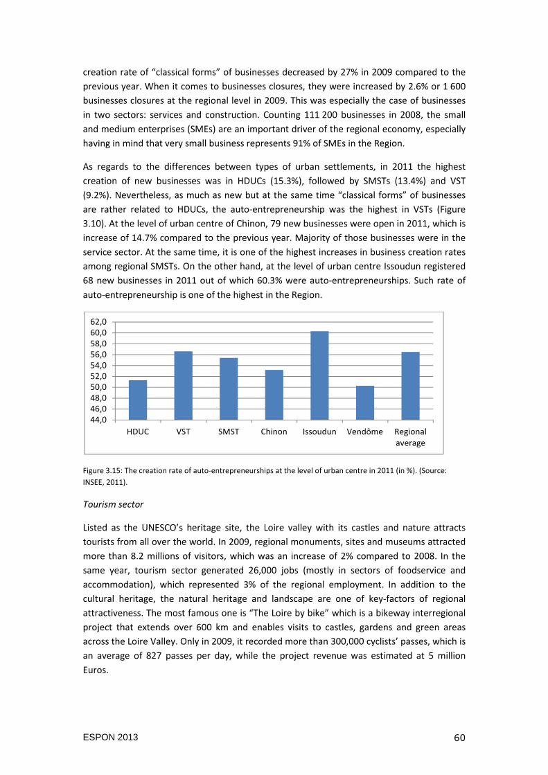
ESPON 2013 60
creation rate of “classical forms” of businesses decreased by 27% in 2009 compared to the
previous year. When it comes to businesses closures, they were increased by 2.6% or 1 600
businesses closures at the regional level in 2009. This was especially the case of businesses
in two sectors: services and construction. Counting 111 200 businesses in 2008, the small
and medium enterprises (SMEs) are an important driver of the regional economy, especially
having in mind that very small business represents 91% of SMEs in the Region.
As regards to the differences between types of urban settlements, in 2011 the highest
creation of new businesses was in HDUCs (15.3%), followed by SMSTs (13.4%) and VST
(9.2%). Nevertheless, as much as new but at the same time “classical forms” of businesses
are rather related to HDUCs, the auto-entrepreneurship was the highest in VSTs (Figure
3.10). At the level of urban centre of Chinon, 79 new businesses were open in 2011, which is
increase of 14.7% compared to the previous year. Majority of those businesses were in the
service sector. At the same time, it is one of the highest increases in business creation rates
among regional SMSTs. On the other hand, at the level of urban centre Issoudun registered
68 new businesses in 2011 out of which 60.3% were auto-entrepreneurships. Such rate of
auto-entrepreneurship is one of the highest in the Region.
Figure 3.15: The creation rate of auto-entrepreneurships at the level of urban centre in 2011 (in %). (Source:
INSEE, 2011).
Tourism sector
Listed as the UNESCO’s heritage site, the Loire valley with its castles and nature attracts
tourists from all over the world. In 2009, regional monuments, sites and museums attracted
more than 8.2 millions of visitors, which was an increase of 2% compared to 2008. In the
same year, tourism sector generated 26,000 jobs (mostly in sectors of foodservice and
accommodation), which represented 3% of the regional employment. In addition to the
cultural heritage, the natural heritage and landscape are one of key-factors of regional
attractiveness. The most famous one is “The Loire by bike” which is a bikeway interregional
project that extends over 600 km and enables visits to castles, gardens and green areas
across the Loire Valley. Only in 2009, it recorded more than 300,000 cyclists’ passes, which is
an average of 827 passes per day, while the project revenue was estimated at 5 million
Euros.
44,046,048,050,052,054,056,058,060,062,0
HDUC VST SMST Chinon Issoudun Vendôme Regionalaverage
ESPON 2013 61
Overall, benefits from tourism are related to the location in the Region. Regardless their size,
cities and towns located in the Loire valley are more likely to attract tourists than those
situated in other areas of the Region. In that respect, Chinon’s area has become a well-
known tourist destination with more than 157,500 visitors each year (four times its
population). Compared to other regional SMSTs, Chinon is ranked on the top in number of
nights in hotel and camping per year. At the level of employment zone, jobs directly
generated from the tourism sector have increased by 9.5% since 2003.
3.3 The socio-economic and demographic performance of SMSTs
Based on results of the functional analysis presented in the previous subsection, we list
some major development characteristics and trajectories followed by SMSTs in the Centre
Region.
• The pressure of urban sprawl: the population growth in the peripheral and sub-
urban area generally raises challenges for the environment (biodiversity destruction,
loss of agricultural land, air pollution due to multiplication of commuters, etc.). In
the case of SMST, additional challenges appear: the possible suburbanization of the
local economy as services tend to follow population; and the costs of provision of
public services (including leisure, sports and culture) for the rural municipalities.
• Facing vacant housing stock: the share of unoccupied dwellings in housing stock of
urban centres of SMSTs has been above the regional average. Moreover, it seems to
continue to increase. On the other hand, prices of land and real estate are
determined by location in the Region, location in the urban centre or the suburbs
and by the municipal property ownership tax and residence tax. Therefore, SMSTs
located in the southern part of the Region record higher percentage of vacant
dwellings than other regional SMSTs.
• The aging population is a general phenomenon. It is more pronounced in SMSTs
that provide a high quality services and quality of life that suits their needs (case of
Vendôme). On the other side, the young population is attracted to larger cities to
pursue their studies and the first working experience. Thus, the exodus of young
people to larger urban areas is a challenging phenomenon in front of SMSTs.
• The shift in labour market: SMSTs have had the highest decrease in industrial
employment. Due to technological changes and global competitiveness, once the
strongest employment sector in SMSTs, the industry was replaced by trade,
transport and public services. The recent economic crisis accompanied by the
closures of manufacturing sites only accelerated the ongoing shift on the labour
market. In addition, SMSTs have seen a decline in the number of traders and
craftsmen entrepreneurs and labour workers in favour of more professional
occupations such as employees, managerial and administrative occupation. In some
SMSTs such the shift is more pronounced due to (i) their position in close proximity
(and accessibility) to a larger city or a metropolitan area, like the Ile de France
ESPON 2013 62
region, (ii) the administrative role they have for their surrounding area and the
existence of services, infrastructure and/or (iii) local strategies to target a high-
income and more educated population.
• Attracting more educated population: overall, the population of SMSTs is less
educated than at the regional average. Partially it is due to general absence of
vocational and higher educational institutions accompanied by exodus of young
population. Towns such as Issoudun and Chinon are exceptional as they are home to
branches of the Tours University and the Orléans University. Nevertheless, some
SMSTs have succeeded to attract highly educated population by offering better and
accessible living conditions as compared to large cities (cases of Amboise and Chinon
vs. Tours).
• Drawing lessons from the economic crisis: in a region with an industrial heritage
and the presence of SMEs as well as neo-fordist branchplants, such as the Centre
Region, SMSTs are particularly concerned by the dynamics of deindustrialization.
The creation of new businesses in services in SMSTs cannot compensate the job
losses in the industrial sector.
ESPON 2013 63
4. POLICY ANALYSIS
As presented in the previous chapter, French SMSTs experience important socio-economic
and demographic changes such as aging population, exodus of young, shift in labour market
and deindustrialization, which are all addressed differently in terms of local policies and
practices. In this chapter we explore how SMSTs are viewed within policy discourses and
their functions understood both within the wider context (European, national and regional)
and in terms of their specific characteristics (demonstrated on three selected SMSTs). In the
first section we give an overview of EU, national and regional policies that impact directly
and indirectly French SMSTs in the case of the Centre region. The second section focuses on
local development policies and practices presented via the cases of Vendôme, Chinon and
Issoudun. In that respect, we synthesize research findings of the fieldwork and interviews
with relevant local actors. In the last section, we draw out wider policy recommendations
based on the comparative analysis of case studies.
4.1 The impact of EU, national and regional policies on SMSTs
In chapter 1, we presented the complexity of the French local government system. Since the
1980s and the decentralization process, more powers and responsibility have been given to
already existing institutions (e.g. municipalities, departements) and new ones have been
established (regions, inter-municipal communities, sub-regional areas) so as to address the
challenges set by the economic crisis. Even though the decentralization is still an ongoing
process, we can observe a multiplication of vertical and horizontal levels of governance that
constitute unique and complex French governance system.
Along with the State, regions at the vertical level of governance create and exercise policies
in two main domains of competences: economic development and education-training. Since
2004, additional competences in heritage, nature and seaports and airports infrastructure
are transferred to some of them as experimental phase. Furthermore, since the French
Revolution departments have been essential for the State administration. They exercise
power in five domains: economic development, social action, education, culture and
planning. Finally, municipality is the basic and the oldest administrative unit. It develops
local policies in planning, health, education, culture and sport.
The horizontal level of governance, on the contrary, was addressed more eagerly with the
territorial reform in 2010. From the 1990s, the inter-municipal communities (EPCI) gained
vigour as an institutionalized form of cooperation between municipalities. From the point of
view of the State, they were introduced as a solution to the fragmentation of the territorial
organization. The joint management of local public services or local development policies
(housing, economic development…) are the core objectives of municipalities’ clusters.
Nevertheless, forms and scales of municipalities’ clusters differ depending on the context
and in some cases not all municipalities have the same enthusiasm to share their powers
with neighbouring municipalities of the same EPCI.
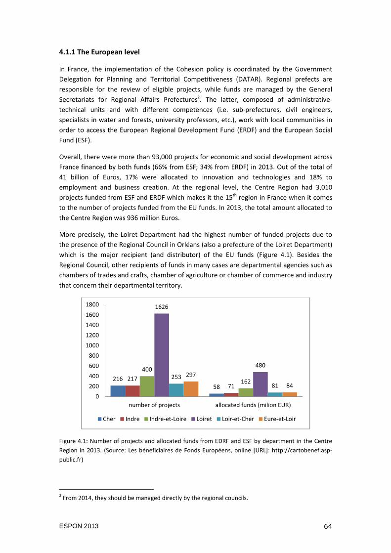
ESPON 2013 64
4.1.1 The European level
In France, the implementation of the Cohesion policy is coordinated by the Government
Delegation for Planning and Territorial Competitiveness (DATAR). Regional prefects are
responsible for the review of eligible projects, while funds are managed by the General
Secretariats for Regional Affairs Prefectures2. The latter, composed of administrative-
technical units and with different competences (i.e. sub-prefectures, civil engineers,
specialists in water and forests, university professors, etc.), work with local communities in
order to access the European Regional Development Fund (ERDF) and the European Social
Fund (ESF).
Overall, there were more than 93,000 projects for economic and social development across
France financed by both funds (66% from ESF; 34% from ERDF) in 2013. Out of the total of
41 billion of Euros, 17% were allocated to innovation and technologies and 18% to
employment and business creation. At the regional level, the Centre Region had 3,010
projects funded from ESF and ERDF which makes it the 15th region in France when it comes
to the number of projects funded from the EU funds. In 2013, the total amount allocated to
the Centre Region was 936 million Euros.
More precisely, the Loiret Department had the highest number of funded projects due to
the presence of the Regional Council in Orléans (also a prefecture of the Loiret Department)
which is the major recipient (and distributor) of the EU funds (Figure 4.1). Besides the
Regional Council, other recipients of funds in many cases are departmental agencies such as
chambers of trades and crafts, chamber of agriculture or chamber of commerce and industry
that concern their departmental territory.
Figure 4.1: Number of projects and allocated funds from EDRF and ESF by department in the Centre
Region in 2013. (Source: Les bénéficiaires de Fonds Européens, online [URL]: http://cartobenef.asp-
public.fr)
2 From 2014, they should be managed directly by the regional councils.
21658
21771
400
162
1626
480
253
81
297
84
0
200
400
600
800
1000
1200
1400
1600
1800
number of projects allocated funds (milion EUR)
Cher Indre Indre-et-Loire Loiret Loir-et-Cher Eure-et-Loir
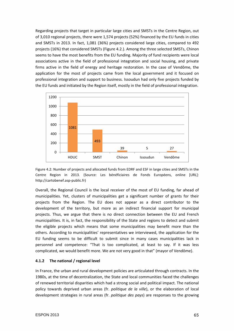
ESPON 2013 65
Regarding projects that target in particular large cities and SMSTs in the Centre Region, out
of 3,010 regional projects, there were 1,574 projects (52%) financed by the EU funds in cities
and SMSTs in 2013. In fact, 1,081 (36%) projects considered large cities, compared to 492
projects (16%) that considered SMSTs (Figure 4.2.). Among the three selected SMSTs, Chinon
seems to have the most benefits from the EU funding. Majority of fund recipients were local
associations active in the field of professional integration and social housing, and private
firms active in the field of energy and heritage restoration. In the case of Vendôme, the
application for the most of projects came from the local government and it focused on
professional integration and support to business. Issoudun had only five projects funded by
the EU funds and initiated by the Region itself, mostly in the field of professional integration.
Figure 4.2: Number of projects and allocated funds from EDRF and ESF in large cities and SMSTs in the
Centre Region in 2013. (Source: Les bénéficiaires de Fonds Européens, online [URL]:
http://cartobenef.asp-public.fr)
Overall, the Regional Council is the local receiver of the most of EU funding, far ahead of
municipalities. Yet, clusters of municipalities get a significant number of grants for their
projects from the Region. The EU does not appear as a direct contributor to the
development of the territory, but more as an indirect financial support for municipal
projects. Thus, we argue that there is no direct connection between the EU and French
municipalities. It is, in fact, the responsibility of the State and regions to detect and submit
the eligible projects which means that some municipalities may benefit more than the
others. According to municipalities’ representatives we interviewed, the application for the
EU funding seems to be difficult to submit since in many cases municipalities lack in
personnel and competence: “That is too complicated, at least to say. If it was less
complicated, we would benefit more. We are not very good in that” (mayor of Vendôme).
4.1.2 The national / regional level
In France, the urban and rural development policies are articulated through contracts. In the
1980s, at the time of decentralization, the State and local communities faced the challenges
of renewed territorial disparities which had a strong social and political impact. The national
policy towards deprived urban areas (fr. politique de la ville), or the elaboration of local
development strategies in rural areas (fr. politique des pays) are responses to the growing
1081
493
39 5 270
200
400
600
800
1000
1200
HDUC SMST Chinon Issoudun Vendôme
ESPON 2013 66
public concerns that the traditional method of sectoral subsidies was inconsistent (Donzelot
and Estèbe, 1994). Developed policies were expected to be multidimensional, based on
context and on “partnership”. The creation of territorial contracts (such as town,
agglomeration or sub-regional contracts) aims to create a synergy between actors in the
fields of urban planning, housing, employment, school, recreation, public services, etc. These
contracts allow a broad mobilization of actors and resources.
Given the fact that the Centre Region is heterogeneous (the northern part under the
influence of the Ile-de-France Region, the Loire Valley polarized between two large
agglomerations, the southern part facing demographic and industrial decline for several
decades), the aim of the Regional Council has been to enable the territorial development
through implementations of policy that ensure services and facilities to municipalities. In
order to organize a fundamentally heterogeneous regional territory, the Regional Council
created segmented contracts, first for rural areas. Later it supported the development of the
eight largest conurbations and more recently medium-sized towns (Demazière, 2005).
In the early 1980s, the Region launched its policy of structuring sub-regional areas (fr. pays)
by means of the Regional and Rural Development Contracts (fr. Contrats Régionaux
d’Aménagement Rural, CRAR). In 1987, the Regional Council confirmed its commitment to
structuring rural areas by launching the Regional Contracts of Local Initiative (fr. Contrats
Régionaux d’Initiative Locale, CRIL). The objective was to encourage the development of
rural areas by creating inter-municipal communities, through intersectoral approach and on
the initiative of local actors. In 1991, forty Regional Contracts of the Local Initiative were set
up, comprising 1,200 municipalities. Since 1994, Regional Contracts were replaced by Sub-
regional Contracts (fr. Contrats de Pays) that kept the same bottom-up approach. Such
regional policy and contracts are based on a three steps: (i) the nomination, (ii) the
elaboration of a development chart with diagnosis and short-term project (10-15 years) and
(iii) the implementation of a 4-year action plan. Such an approach was successful since 30
sub-regional areas that cover the Region have been identified between 1995 and 2000. In
the recent period, the Regional Council devotes 185 million euros to the contrats de pays,
over a period of 5 years. Nevertheless, the analysis at the level of individual cases reveals a
frequent lack of structured development plan and actions’ objectives that lack in originality
(opening up the territory, promoting employment and integration, preserving the
environment, etc.). There is also the absence of spatial coherence of sub-regional areas that
are formed around large cities of Orléans, Tours, Blois or Montargis. In these cases, there is
no effort to improve the interdependence between rural (often suburban) and urban areas
(Demazière, 2005).
Moreover, in 1998, the Centre Region launched the Agglomeration Contracts (fr. Contrats
d’agglomération) targeting large cities. Even though the signing procedure was the same as
for the Sub-regional Contracts, the policy intentions for the Agglomeration Contracts were
higher: “to organize the major urban functions at the regional level” and “to promote the
implementation of development programs as part of regional planning”. However, while the
Regional Council originally intended to support two or three flagship projects in each city,
the final approved programs included a high number of actions in various domains (housing,
transport infrastructure, economic development, public services, quality of life, etc.) (Boutet,
2003). Contractual relations between the Region and the 8 signatory cities are essentially
ESPON 2013 67
formal and financial by nature. In the recent period, the regional council devotes 155 million
euros to such contracts, which last five years.
Finally, in 2000, the Centre Region initiated a reflection on “poles of centrality” which led to
creation of the Medium-Sized Town Contracts (fr. Contrats de Villes Moyennes). The
definition of the medium-sized town was not only the demographic criterion, but also the
INSEE’s distinction between urban and rural centres based on job commuting (but also on
provision of services). In order to be eligible, medium-sized towns had to satisfy several
conditions:
• at least 3,000 inhabitants
• not belonging to any agglomeration
• having:
o at least 5,000 jobs if a municipality or an urban centre is big enough to be
classified as travel-to-work area (fr. aire urbaine)
o from 2,000 to 5,000 jobs or a number of jobs at least equal to the number of
active residents if a municipality or an urban centre is located in rural areas.
(In case that urban centre meets these conditions, only its central
municipality is eligible).
o or, more than 7,000 inhabitants
The contract is signed with the town centre (its central municipality). In order to benefit
from this policy, a town that is considered to be medium-sized needs to draft an urban
project and to propose a clearly defined development strategy that enables it to carry out
the centrality functions and to enhance its attractiveness. In that respect, three intervention
areas are highlighted: urban renewal, improvement of reception capacities for population
and improvement of quality of life. The municipality needs to prepare an action plan that
defines operations and financing modes for the Region over a 4-year time period. Hence, a
contract is based on a program of actions and urban development project. Therefore, the
Policy of medium-sized towns does not imply the economic development, but mainly the
financial support of projects related in many cases to construction of cultural and sports
facilities. After the adoption of the Policy of medium-sized towns, out of 40 potential towns,
22 towns have expressed their intentions to sign the Medium-Sized Town Contract. In the
end, 20 contracts were signed. The total amount of this policy was 14 million Euros.
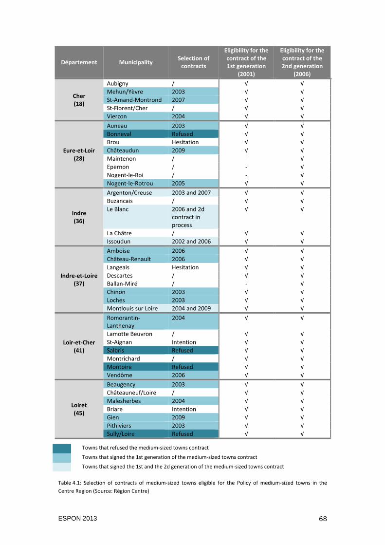
ESPON 2013 68
Département Municipality Selection of
contracts
Eligibility for the
contract of the
1st generation
(2001)
Eligibility for the
contract of the
2nd generation
(2006)
Cher
(18)
Aubigny / √ √
Mehun/Yèvre 2003 √ √
St-Amand-Montrond 2007 √ √
St-Florent/Cher / √ √
Vierzon 2004 √ √
Eure-et-Loir
(28)
Auneau 2003 √ √
Bonneval Refused √ √
Brou Hesitation √ √
Châteaudun 2009 √ √
Maintenon / - √
Epernon / - √
Nogent-le-Roi / - √
Nogent-le-Rotrou 2005 √ √
Indre
(36)
Argenton/Creuse 2003 and 2007 √ √
Buzancais / √ √
Le Blanc 2006 and 2d contract in process
√ √
La Châtre / √ √
Issoudun 2002 and 2006 √ √
Indre-et-Loire
(37)
Amboise 2006 √ √
Château-Renault 2006 √ √
Langeais Hesitation √ √
Descartes / √ √
Ballan-Miré / - √
Chinon 2003 √ √
Loches 2003 √ √
Montlouis sur Loire 2004 and 2009 √ √
Loir-et-Cher
(41)
Romorantin-Lanthenay
2004 √ √
Lamotte Beuvron / √ √
St-Aignan Intention √ √
Salbris Refused √ √
Montrichard / √ √
Montoire Refused √ √
Vendôme 2006 √ √
Loiret
(45)
Beaugency 2003 √ √
Châteauneuf/Loire / √ √
Malesherbes 2004 √ √
Briare Intention √ √
Gien 2009 √ √
Pithiviers 2003 √ √
Sully/Loire Refused √ √
Table 4.1: Selection of contracts of medium-sized towns eligible for the Policy of medium-sized towns in the
Centre Region (Source: Région Centre)
Towns that refused the medium-sized towns contract
Towns that signed the 1st generation of the medium-sized towns contract
Towns that signed the 1st and the 2d generation of the medium-sized towns contract
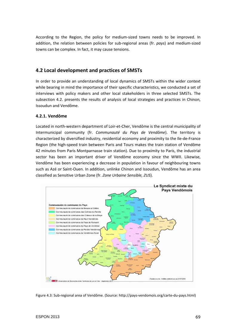
ESPON 2013 69
According to the Region, the policy for medium-sized towns needs to be improved. In
addition, the relation between policies for sub-regional areas (fr. pays) and medium-sized
towns can be complex. In fact, it may cause tensions.
4.2 Local development and practices of SMSTs
In order to provide an understanding of local dynamics of SMSTs within the wider context
while bearing in mind the importance of their specific characteristics, we conducted a set of
interviews with policy makers and other local stakeholders in three selected SMSTs. The
subsection 4.2. presents the results of analysis of local strategies and practices in Chinon,
Issoudun and Vendôme.
4.2.1. Vendôme
Located in north-western department of Loir-et-Cher, Vendôme is the central municipality of
Intermunicipal community (fr. Communauté du Pays de Vendôme). The territory is
characterized by diversified industry, residential economy and proximity to the Ile-de-France
Region (the high-speed train between Paris and Tours makes the train station of Vendôme
42 minutes from Paris Montparnasse train station). Due to proximity to Paris, the industrial
sector has been an important driver of Vendôme economy since the WWII. Likewise,
Vendôme has been experiencing a decrease in population in favour of neighbouring towns
such as Azé or Saint-Ouen. In addition, unlinke Chinon and Issoudun, Vendôme has an area
classified as Sensitive Urban Zone (fr. Zone Urbaine Sensible, ZUS).
Figure 4.3: Sub-regional area of Vendôme. (Source: http://pays-vendomois.org/carte-du-pays.html)
ESPON 2013 70
Improvement in quality of life
The municipality has launched various initiatives in rehabilitation of public spaces, roads and
infrastructure so to attract and keep the population. Indeed, facing challenges of an aging
population, job loss, raising unemployment, Vendôme decided to renew its services and
facilities. To give an example, for the renovation of its historic and natural heritage, nearly
1.3 million Euros were invested in different operations from 2010 to 2012.
One way to improve the quality of life (seen by Vendôme) was the restoration of social
housing in order to create a social mix in neighbourhoods. Concerning social housing, the
town started with the construction in new urban areas (north, centre and south). “Such
spatial distribution will facilitate access to housing and will allow those with difficulties, to
choose their neighbourhoods”. When it comes to private housing, through the elaboration of
the Local Development Plan (fr. PLU), Vendôme detected the area in the centre that needed
to be denser. “We are trying to densify instead of extending into the countryside and forest.
In order words, a habitat, that Vendôme does not have, could correspond to needs of young
families which ultimately will prefer to find services in the town” (mayor of Vendôme). These
operations of rehabilitation are heavy for the municipal budget. Over the period of 4 years
(2010-2013), 12.6 million Euros has been spent.
When it comes to environment, in 2009, Vendôme launched a Zero Pesticide Plan that
refrained from using pesticides in public spaces. The Plan was accompanied by activities in
educating and raising awareness among people on pesticide impacts. This policy led to the
creation of the Local Agenda 21 entitled “The Future is Now” prepared in 2010.
In this sense, the Green and the Blue Frame (TVB) have been created in order to allow the
identification of ecological corridors. Also, the Architecture and Heritage Area (AVAP) was
set to protect historical monuments.
Likewise, a new wastewater treatment unit (WWTP) is planned to be constructed in 2014 for
three municipalities: Vendôme, Saint-Ouen, Meslay Areines. It will replace the current
station that does not meet the regulatory requirements for protection of the environment.
Solidarity
Vendôme has an impressive base of associations organised in conjunction with the social
sector, sport and culture. They have been created with the aim to help people with
difficulties in finding a job, to train for a career transition or to encourage employment.
When it comes to aid to individuals such as delivering meals to the elderly, Vendôme
associations are numerous. To support them, Vendôme has provided subsidies of
approximately 440,000 Euros per year and it has organized the “Associations’ Day”. In
addition, town has also built the Jules Ferry community centre, the Solidarity and Health
voluntary centre and the Medical and Educational Institute.
Accessibility to services and facilities
Vendôme has several cultural facilities: the Minotaur auditorium, the music school, the
library, a museum and many heritage sites. New facilities have been under construction: the
ESPON 2013 71
new cinema CinéVendôme, the conversion of the Ronsart cinema into a youth centre, a new
site for the music school and a new pool. Town also has the Nursery Centre and the Elderly
Home managed by the Inter-municipal Centre for Social Action.
In order to facilitate administrative procedure, Vendôme has launched innovative initiative
to improve availability and accessibility of services and to reduce public spending. The
municipality of Vendôme and the Inter-municipal community have unified and harmonized
service for families by creating a single administrative procedure for families (registration
procedures, childcare, services rates, etc.).
Attracting businesses
The municipality seeks to revitalize its business fabric (including innovative SMEs) to regain
in people and skills, and to reduce unemployment. Nevertheless, as economic development
is one of competences of the Intermunicipal community, all policy decisions are taken by
that body which sometimes causes conflicts between municipalities, especially rural and
urban municipalities. In that respect, the example of commercial planning is interesting to
present. In 2005, Vendôme created the Commercial Planning Chart that had to bring
together all local actors in trade sector and to establish rules in evaluation of all commercial
projects. Such an initiative allowed Vendôme to control installation of shops and to
intervene if the balance in commercial offer was threatened. Nevertheless, already in the
same year, the Department imposed the so-called Plan on Business Development which
denied the town the right to decide in this issue and to regulate the commercial offer any
longer.
As another measure to enable business and job creation in Vendôme, has been the
investment in real estate by renting out the space for businesses and artisans. In 2007, the
Inter-municipal community initiated a workshop to facilitate new start-ups and to provide
conditions for economic actors. Private initiatives also seek to help businesses in the area.
For example, a group of employers formed an organization called “Shared Trades” that has
antennas in Vendôme and Romorantin-Lanthenay (the headquarters of the organization are
in Blois).
Conclusion
Vendôme is an example of SMST facing challenges of mobile society. The arrival of TGV in
the early 1990s was seen as a huge opportunity for the local development of Vendôme. The
commuting time between Vendôme and Paris was drastically improved and the frequency of
trains on a daily basis increased. Nevertheless, even after 20 years of its presence, the so-
called “TGV effect” still raises doubts about sustainability of jobs and income for Vendôme.
The reason is the high commuting between Vendôme and Ile-de-France which seems not to
be in favour of a small town.
On one hand, entrepreneurs travel daily to Vendôme to work, but they continue to live in
Paris. As a result, qualifications of workforce and employment in R&D sector have increased
in Vendôme. Thus, there is a very strong link between big infrastructures such as TGV and
evolution of the area. In addition, neighbouring municipalities may have more benefits from
ESPON 2013 72
TGV than Vendôme itself. The less expensive land in neighbouring municipalities compared
the one in Vendôme, with TGV station in the near proximity, have raised competition
between municipalities.
On the other hand, taken from the other perspective, majority of Parisians stay unaware
that Vendôme is within 45 minutes from Paris by TGV. No wonder that Vendôme has been
considering a partnership project with SNCF that would attract Parisians by offering them
tourist weekend packages to visit the town.
Finally, another issue that marks Vendôme is the inconsistent intermunicipal cooperation.
The Rural Inter-municipal community (fr. Communauté de Communes du Vendômois Rural)
which represents 5,500 inhabitants in 7 municipalities is fragmented and entangled with the
Inter-municipal community of Vendôme (fr. Communauté du Pays de Vendôme). The merger
of these two inter-municipal communities in conflict is difficult to envisage. In fact, the
difficulty lies in contrast between “rural” and “urban” that restrains the cooperation for
common territorial development. Rural communities have a certain distrust of town centre
and fear of being suffocated by it.
4.2.2. Chinon
Chinon is the central municipality of the Inter-municipal community Rivière, Chinon, Saint-
Benoît la Forêt and a member of the Chinon subregional area (fr. Syndicat Mixte du Pays du
Chinonais). The prestigious past and attractive landscape have provided a rich heritage to
Chinon. As “Town of Art and History” with two Natura 2000 sites, the Regional Natural Park
“Loire-Anjou-Touraine”, gastronomy with controlled designation of origin for wine (Chinon,
Bourgueil and Saint-Nicolas-de-Bourgueil), the hospital centre on the former military site,
nuclear power plant in the nearby town of Avoine, Chinon has diverse assets for local
development.
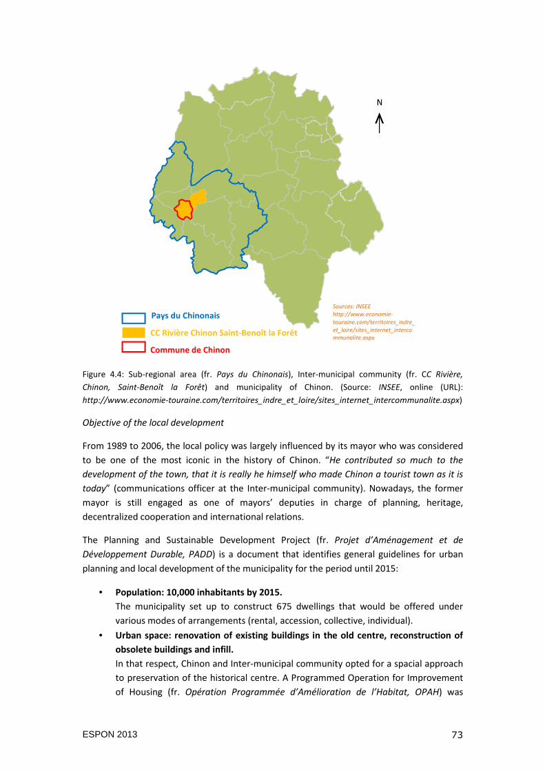
ESPON 2013 73
Figure 4.4: Sub-regional area (fr. Pays du Chinonais), Inter-municipal community (fr. CC Rivière,
Chinon, Saint-Benoît la Forêt) and municipality of Chinon. (Source: INSEE, online (URL):
http://www.economie-touraine.com/territoires_indre_et_loire/sites_internet_intercommunalite.aspx)
Objective of the local development
From 1989 to 2006, the local policy was largely influenced by its mayor who was considered
to be one of the most iconic in the history of Chinon. “He contributed so much to the
development of the town, that it is really he himself who made Chinon a tourist town as it is
today” (communications officer at the Inter-municipal community). Nowadays, the former
mayor is still engaged as one of mayors’ deputies in charge of planning, heritage,
decentralized cooperation and international relations.
The Planning and Sustainable Development Project (fr. Projet d’Aménagement et de
Développement Durable, PADD) is a document that identifies general guidelines for urban
planning and local development of the municipality for the period until 2015:
• Population: 10,000 inhabitants by 2015.
The municipality set up to construct 675 dwellings that would be offered under
various modes of arrangements (rental, accession, collective, individual).
• Urban space: renovation of existing buildings in the old centre, reconstruction of
obsolete buildings and infill.
In that respect, Chinon and Inter-municipal community opted for a spacial approach
to preservation of the historical centre. A Programmed Operation for Improvement
of Housing (fr. Opération Programmée d’Amélioration de l’Habitat, OPAH) was
Sources: INSEE http://www.economie-touraine.com/territoires_indre_et_loire/sites_internet_intercommunalite.aspx
Pays du Chinonais
CC Rivière Chinon Saint-Benoît la Forêt
Commune de Chinon
ESPON 2013 74
launched at the level of Inter-municipal community between 2006 and 2009. Also,
Chinon created several plans for protection of architectural heritage and urban
landscape and for prevention of flood risk of Vienna River.
• Economy: good conditions for business and quick response to project needs.
By 2015 about 20 hectares will be available for business. When it comes to
agriculture, Chinon wishes to maintain and strengthen wine production.
• Environment: recreational areas, new river walks and forest preservation.
By relying on the Inter-municipal community, Chinon plans to create new green
spaces, i.e. on the Ile-de-Tours.
• Mobility: parking in the town centre, parking reservoir during events and incentive
to non-motorized travel.
Chinon encourages diverse modes of travel (i.e. new lines for bicycles). Speed in
some downtown streets was limited to 20km per hour. Four bus lines promote
public transport. The town’s Commission for public space has proposed to close the
historical centre and the hillside area for all motorized travels.
Cooperation and partnership
Chinon has been promoting international relations since the 1960s. Town is twinned with
three European cities: Hofheim in Germany (since 1967), Tiverton in UK (since 1973) and
Certaldo in Italy (since 2010). Moreover, Chinon has been active in aid cooperation for Luang
Prabang in Laos (since 1995) and the city of Tenkodogo in Burkina Faso (since 2006). The
Ministry of Foreign Affairs, the Centre Region and private partners have supported Chinon’s
initiative as well. In 2011, a new partnership was created with the Xiangsi Region in China.
For Chinon’s Mayor “the opening to the world is a factor for international visibility, but also a
tool for economic development and tourism”. The economic impact of these partnerships is
difficult to assess. Nevertheless, the officer in charge of international cooperation and
twinning highlighted the spillover effects: “First, from a human point of view, we help, which
is already a good reason to be engaged. Second, there are concrete and long-term benefits
for which the Loire Valley is a world heritage site. The link does not seem obvious, but when
Luang Prabang, the former capital of Laos was classified the world heritage in 1995, Chinon’s
mayor was part of the UNESCO group of experts who helped Laos getting the label. That has
been the goal of this partnership for 20 yea now, acquiring experience so to classify the Loire
Valley for the UNESCO world heritage”.
In terms of inter-territorial cooperation, three inter-municipal communities (Pays d’Azay-le-
Rideau, Pays du Bourgueillois and Rivière-Chinon-Saint-Benoît la Forêt) grouped in the
network called “Undertake Chinon” (fr. Entreprendre en Chinonais) that promotes sharing of
resources and know-how in order to support business. The network coordinator who is also
in charge of economic development of one inter-municipal community involved argued that
“a company that cannot find its location on our territory will go next door and become a
competition. As we work together now, the inter-municipal rivalry is broken”.
ESPON 2013 75
Building image of the territory
Tourism and businesses are key priorities of Chinon. The number of undertaken projects
confirms the commitment of Chinon to preserve its resources so to benefit from the touristic
potentials. Besides the natural heritage, Chinon has a rich historical heritage as well: the
Castle of Chinon, the Royal Fortress, the Church of St. Maximin and the Chapter of Ste.
Radegonde. Their maintenance is a significant financial cost for Chinon.
The General Council of Indre-et-Loire Département is the owner of Chinon’s Royal Fortress
and is also the second largest land owner of historical heritage in France (right after the Ile-
de-France Region). The Council has recently engaged in one of the greatest restoration
projects in Europe - the Royal Fortress with its 500m long fortification. Having for the aim to
attract 200,000 visitors per year, the preservation works on the Fortress lasted for 7 years
(from 2003 to 2010). More than 17 million euros, including 12 million euros from the
General Council Indre-et-Loire were invested in that restoration. “Clearly, there is a reason.
The restoration of the Fortress and the town’s centre reinforces the image of the town; so
obviously, it helps us to be more economically attractive” (coordinator of the Undertake
Chinon Network).
In 2009, the rehabilitation of Saint-Michel Hospices took place. As the cloister in the 17th
century, the Saint-Michel Hospices hosted a branch of the University Hospital reserved for
the elderly. After the rehabilitation of 3,200 m2, a total of 46 dwellings were constructed,
including 15 social housing units, public and private parks and parking. The investment was
estimate on 6.9 million Euros. The Saint-Michel Hospices rehabilitation got even the National
Award “Gesture of gold” as exemplary work in heritage preservation.
For March 2014, a construction of 84 new tourist residences is planned. With the potential
to host 10,000 overnight stays per year, Chinon plans to increase the capacity of
accommodation of tourists, which would generate impact on trade. The Regional Council
participates in this project with the investment of 300,000 Euros, while the Department and
Inter-municipal community plan to invest 50,000 Euros each.
Innovations and entrepreneurship
The Tours University branch located in Chinon offers licence in engineering aquatic
environments and river transport corridors. This unique training is accompanied by the
Centre of Expertise and University Transfer (CETU) established by the University of Tours.
The CETU promotes public-private partnerships (laboratories, research organizations and/or
companies) in order to provide expertise on ecological functioning and management of
rivers and wetlands. Moreover, the DREAM cluster located in Orléans is also involved in
cooperation between university research and business in town. The Chinon business
incubator has been established with the goal to support professionals in their work on river
corridors. The Incubator was supported by laboratory LCA and the SARL Rive Research and
Engineering Office specialized in management and restoration of rivers and wetlands.
In addition, a new project of rehabilitation of Danton dock is estimated on 2.5 milion Euros.
The aim of the project is to popularize scientific research on water and the river, and at the
ESPON 2013 76
same time to have investment returns to the Intermunicipal community. The ground floor of
the Danton dock would present works of students and entrepreneurs, while upstairs would
be used as a student residence. The Intermunicipal community is currently looking for
funding for that project.
Conclusion
The town of Chinon and its hinterland have important touristic assets (landscape, cultural
heritage, vineyards, woods, urban and rural atmospheres) which have been preserved and
valorized, thanks to local actors. In parallel, Chinon has reasserted its role of service
providers to its inhabitants and to a larger territory. Here, one may mention the hospital
which added private resources to public ones, the institute for autonomy and social
insertion or the residence for old and dependent persons. The municipality also shows a
strong will to react to the deficit of young people, by developing a project of a home for
students or apprentices. This initiative is supported by the General Council of Indre-et-Loire.
Tourism is a key sector for the local economy, but many actors stress the lack of connections
between the Fortress and the town centre. This may be due of a lack of communication on
the other remarkable monuments, and place-branding should be recommended. The
weaknesses of some economic actors themselves should be noted, especially hotels and
restaurants. For instance, most of the restaurants in the city center do not serve any meal
after 9 pm and do not propose any menus in a foreign language.
The three inter-municipal communities covering the territory of Chinon will merge in
January 2014 (Communauté de Communes Rivière Chinon Saint-Benoît la Forêt,
Communauté de Communes du Véron, Communauté de Communes Rive Gauche de la
Vienne) into a single entity, the Communauté de Communes Chinon Val-de-Loire (CCCVL).
This will gather 16 communes and more than 20,000 inhabitants and at the same time it
may constitute a positive change for the municipality of Chinon, as it is indebted. The
financial and human resources are to increase, even though the global economic context is
uncertain. If this union works, the town and the territory of Chinon may become more
ambitious.
4.2.3. Issoudun
Issoudun is located in the centre of Champagne Berrichonne area that got the name after
the land that covers the southern part of the Region. Issoudun is also the central
municipality of the Inter-municipal community (fr. Communauté de Communes du Pays
d’Issoudun). Affected largely by global changes and recent economic crisis, Issoudun is
receiving the State aid (fr. Aides à Finalité Régionale) for support jobs creation and new
investments (mostly in industry). Issoudun is also classified as Area of Rural Revitalization (fr.
Zones de Revitalisation Rurales, ZRR) which allows local firms to get some tax benefits such
as exemption from contributions to social insurance, family allowances, transport tax and
they have housing assistance benefits for their employees.
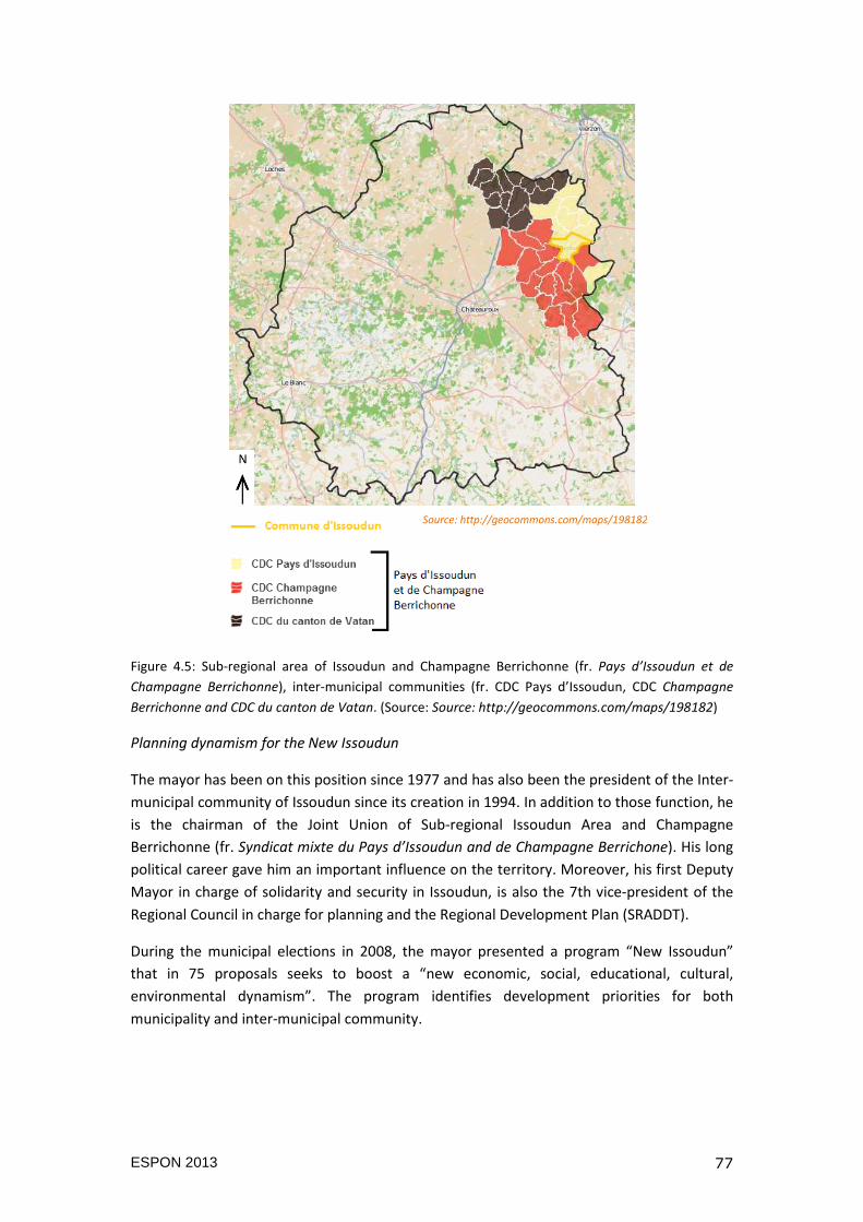
ESPON 2013 77
Figure 4.5: Sub-regional area of Issoudun and Champagne Berrichonne (fr. Pays d’Issoudun et de
Champagne Berrichonne), inter-municipal communities (fr. CDC Pays d’Issoudun, CDC Champagne
Berrichonne and CDC du canton de Vatan. (Source: Source: http://geocommons.com/maps/198182)
Planning dynamism for the New Issoudun
The mayor has been on this position since 1977 and has also been the president of the Inter-
municipal community of Issoudun since its creation in 1994. In addition to those function, he
is the chairman of the Joint Union of Sub-regional Issoudun Area and Champagne
Berrichonne (fr. Syndicat mixte du Pays d’Issoudun and de Champagne Berrichone). His long
political career gave him an important influence on the territory. Moreover, his first Deputy
Mayor in charge of solidarity and security in Issoudun, is also the 7th vice-president of the
Regional Council in charge for planning and the Regional Development Plan (SRADDT).
During the municipal elections in 2008, the mayor presented a program “New Issoudun”
that in 75 proposals seeks to boost a “new economic, social, educational, cultural,
environmental dynamism”. The program identifies development priorities for both
municipality and inter-municipal community.
Source: http://geocommons.com/maps/198182
ESPON 2013 78
Local business stimulation
As one of the measures for economic development based on trade, industry, crafts and
services, housing stock and business support, 40 hectares are available at the price per
square meter that below average price in the Centre Region. “We have prices between 5 and
10 Euros per square meter in industrial areas and between 15 and 16 Euros in commercial
areas which is all relatively low, but still quite reasonable” (General Services Director of
Issoudun and Inter-municipal Community). Nevertheless, the Chamber of Trade and Crafts
(fr. CMA) that works directly with local companies points at the lack of adequate space
which in turn pushes away companies that wanted to settle in Issoudun.
Furthermore, the Business Village was created with the help of the State and the Region:
“Firms located in Issoudun were obsolete, non-functional, cramped and poorly accessible.
The Business Village is our answer to provide better quality, working conditions and lower
energy expenditure”.
Likewise, in 2010, the Intermunicipal Community founded the Society for Renewable Energy
(SEMER) as a public-private partnership. Together with Nordex Company, 15 million Euros
were invested in the wind farm located in the Intermunicipal community. Indeed, the energy
self-sufficiency is seen as important goal for Issoudun: “Wind energy would assure self-
sufficiency of Issoudun. When it comes to the potential of the wind farm energy production,
the whole subregional area of Issoudun and Champagne Berrichonne with their 32,000
residents would be autonomous in energy”. Today, Issoudun considers diversifying the
Society’s activities by investing in other types of renewable energy such as solar farms that
would be located on a former nearby landfill. A biomass boiler is also one of the projects
envisaged. 3.5 million Euros is planned be invested in heating network for public facilities in
the business zone Champs d’Amour.
Improving the training offer
In partnership with the Centre for Image Art and Education established in Issoudun in 1989,
the municipal Institute for vocational training provides courses in art and show production.
Such trainings are innovative and unique even at the regional level. The town also has the
University branch of Technology that offers professional licence in communication and
marketing of cultural products, and two university degrees in marketing techniques and
logistics and transportation. These trainings are unique in the southern part of the Region
(others are located in Tours and Chartres). The reason for organization of special training is
to increase the number of students and to keep them from moving to Tours, Orléans or
Limoges to pursue their studies. “We do not have sufficient critical mass, so it is more of a
strategic positioning. There are some courses that may be of local importance to
attractiveness”.
Densification of town centre and social housing
In terms of housing stock, Issoudun offers a variety from suburban dwellings to social
housing units. The mayor has been committed to the construction of social housing units
and their maintenance in partnership with social landlords. Usually such operations are
ESPON 2013 79
carried out by the National Agency for Urban Renewal (ANRU). However, in case of
Issoudun, it has been at the initiative of the town in close collaboration with Scalis Company.
To give some example from the budget, the Habitat project is estimated on 1.715 million
Euros for the construction of suburban dwellings, 1.215 million Euros for the rehabilitation
of buildings and 600,000 Euros for landscaping and waste disposal. Facing the problem of
vacant private housing, the undertaken initiative called Operation Programme on Habitat (fr.
Opération Programmée sur l’Habitat, OPH) aims to put 250 to 300 new dwellings on the
market over the next five years.
Over the last 20 years, about 500 dwellings have been constructed in the town centre. This
initiative lasted too long due to difficulties in buying small dilapidated houses. Besides, the
image of the town centre was deteriorated as “many traders did not consider reopening
their business and they never renovated their shops. We have the idea of connection of
treating urban aesthetic including facades and a better image of the town” (General Services
Director of Issoudun and inter-municipal community).
Accessibility to services and quality of life
For the majority of interviewed local stakeholders, the accessibility to services and facilities
is of a great importance. Culture, education and youth are key priorities of local policy.
“Besides economic development, there is the choice to have culture and the choice to have
sports facilities for everyone” (Chairman of the Development Council of the Inter-municipal
Community). In that respect, a wave pool was constructed in the 1980s, followed by the
water sports centre, the ELF leisure centre and the bowling centre. Issoudun also has the
Exhibition and Sports Hall (PEPSI), several gymnastic halls, a skating rink and an athletics
stadium which hosts international competitions. At the level of inter-municipal community,
there is the Fay Airfield which is also known as the European gliding centre. The Expression
and Recreation House of Issoudun (MELI) offers to residents more than 50 activities such as
fitness training, babysitting training, hiking, vintage motorcycles, etc..
Besides renewal of facilities and services offered to its population, Issoudun has established
the first cultural cooperation between different institutions: the Museum of the Hospice
Saint-Roch, the Cité de la musique, the congress centre and local television Berry Issoudun
Première (Bip TV). The latter represents an innovation for a town of that size. The Bip TV was
created in 2007 and broadcasts across the Indre Départment. Recently it upgraded its
website so the chain is now available on tablets and smartphones.
Finally, in order to ease access to services, the public transport is free of charge. There are
two bus lines that operate several half-days per week and that connect urban and rural
municipalities. “This is a service that we mastered well because we really wanted to calibrate
a service according to needs. In other words, we have not multiplied nor made bus network
dense as did some towns. They ended up with huge operating costs”.
Conclusion
Considering its small size and its insertion in a depressed sub-regional part of the Centre
region, Issoudun seems to have been quite successful in developing local projects. For
ESPON 2013 80
instance, the good supply in equipments and services was not obvious, regarding the relative
proximity of other SMST (like Vierzon) or the larger cities of Bourges and Châteauroux.
Furthermore, the industrial base is still solid and globally this territory seems to be resilient.
However, the active population is low qualified, which means that the local policy did not
succeed to attract new, more qualified population. Furthermore, the local authorities have
no weight in the hypothetical project of a new high-speed train line Paris-Orléans-Clermont-
Lyon. As a result, Issoudun is only networked to other SMSTs or larger cities which are not
dynamic in social, cultural or economic terms.
According to many actors, the success of the town is clearly linked to the leadership of its
mayor, in power since 1977 and minister in several governments throughout the 1980s. This
exceptional political stability made possible to develop projects with no immediate financial
return, and more globally to develop a local development strategy which seems to be lacking
in many other SMSTs.
4.3 Policy recommendations
While being recognized a key component of the French urban landscape, small and medium-
sized towns continue to suffer from several difficulties and insufficiencies that lower their
potential in terms of local development, adaptation and contribution to the regional and
national economic growth and competiveness. Besides various contextual and recent factors
(especially the effects of economic and financial crisis, and the increasing competitive
pressure exerted by the combination of globalization and metropolisation dynamics), the
fragile situation of French SMSTs is mostly related to structural factors, mainly institutional
and organizational.
At least three sources of structural weaknesses impacting French SMSTs’ socioeconomic
potential can be identified, which call for radical policy changes as regarding the
organization and the functioning of the French territorial system as a whole, and of the role
and action capabilities of SMSTs in particular. As illustrated in the three case studies
analysed in Chapters 2 and 3, these weaknesses take various forms depending on the
context and profile of the SMST considered, but they are obviously common features of
most French SMSTs.
• Vertical coordination
As emphasized in Chapter 1, the French territorial system is characterized by an extreme
administrative fragmentation and various layers of vertical organization: the national state,
‘régions’, départments’, ‘communes’... and various intermediate layers of decision-making
and action levels. As it stands, this territorial scheme is creating complexity and weak
visibility as regarding decision-making processes and the allocation of resources. In this
context, SMST’s have few means for drawing the relevant ‘boundaries’ of their policies and
development strategies, not speaking of the difficulties they must face when trying to
identify the “degrees of freedom” they can have in designing their strategies and action
ESPON 2013 81
plans for local socio-economic development. As a result, most French SMST’s are trapped in
an institutional system they don’t really understand while at the same time coping with a
bundle of economic, financial and societal uncertainties which blur their action horizon and
their “workable” socioeconomic orientation.
Obviously, while multiscalarity in administrative territorial organization is not specific to
France, French SMST’s probably more than others suffer from a rigid territorial vertical
organization which does not help for an efficient territorial coordination where SMST’s could
find their specific place and role. Moreover, in the recurrent debates in France about the
need for a “territorial reform” (especially as regarding a vertical simplification and a more
compact territorial scheme), only few attention is devoted to the specific situation of SMSTs
per se and to their role in economic development. Rather, the reflection is concentrating on
more classical issues (suburbanization in general, fiscal and financial problems, etc.). Only
very recently some voices have pointed out the critical situation of many SMSTs. This new
‘eye’ open on the ‘reality’ of SMSTs is due to a combination of contextual factors,
particularly: the loss of jobs following the closing down of many factories located in SMSTs;
the education system reform just implemented which creates a lot of problems to small
municipalities; and the financial restriction of resources devoted to some key public services
operated at the local level.
• Horizontal cooperation and inter-municipal coherence
At the horizontal level, the fragmentation of the French territorial system in over than
36,000 municipalities creates an inefficient situation resulting in a huge dispersion of
resources, a weak capacity of action and an inter-municipal exacerbated competition for
attracting businesses and residents, for capturing fiscal resources.
The creation of a variety of inter-communal cooperation tools (see above Chapter 1) was
precisely directed toward facilitating the coordination among municipalities and constituting
a ‘critical mass’ of resources and capacity of action. Unfortunately, these coordination
devices are structurally complex and open new doors for territorial competition (this time,
between neighbouring inter-communal arrangements) while the competition between
municipalities within the same inter-municipal community is far from being attenuated or
‘domesticated’. In fact, while SMSTs are particularly interested (and, in fact, constrained) in
(to) cooperate because of their limited resources and action capacities, the reality resembles
in many cases just to a more ‘civilized battle among churches’, where every municipality
cooperates to the extent that it can ‘earn something’ from the collective arrangement while
preserving its specific sources of economic advantage (‘free rider game’).
At the same time, the recognition of the need to move toward merging neighbouring inter-
municipalities and the encouraging results of some pioneer experiences are good steps for
better pooling the local resources in certain domains and better valorising the
complementarities among spatially interdependent territories. But, here again, ‘political
games’ are remaining the rule due especially to the non-binding character of the territorial
arrangements that are implemented, not to speak of the vast room for institutional
interpretation that such arrangements offer.
ESPON 2013 82
All in all, horizontal cooperation is suffered (or felt as painful or inefficient) by many SMSTs
while their socioeconomic difficult situation is collectively worsened by a lack of efficient
cooperation and coordination.
Taken together, the inefficiencies in vertical and horizontal territorial coordination in France
place many SMSTs in precarious situation which mainly illustrates the uncertainties beard by
rather incoherent decentralization and devolution policies in France over the last three
decades. Therefore, French SMSTs are deemed to ‘navigate’ without clear institutional
direction and landmarks while at the same time most of them are confronting severe
problems of deindustrialization and job losses that require the design and engagement in
adapted strategies of economic reconversion and redevelopment.
Still, the strategic move that is needed is itself challenging as many French SMSTs suffer from
of a lack of competences in strategic planning and in the coordination of local actors
• Local competences in strategic planning, in actors’ coordination and in territorial
marketing
As demonstrated in the three towns from the region Centre analyzed above (but also
documented in several other ones studied in another research project at the regional level
(Demazière, 2012), the lack of technical and strategic competences for development and
adaptation planning appear to be one key difficulty for SMSTs. Neither the municipal
representatives, nor the local technical services are equipped with the knowledge,
capabilities and experience that can help them make an accurate diagnosis of their
socioeconomic situation, identify new potential opportunities and drivers for
redevelopment, and design and implement plans for long term economic and social
sustained development. One pitfall illustrating such lack is the absence of awareness as
regarding the dangers of a too strong specialization in a certain industry or service sector.
The same lack appears when we come to local actors’ coordination competences. Indeed,
while some SMSTs have the chance to benefit from the location in their territory of some
key economic, social or academic actors, they often underestimate or even ignore the
potentialities that could be valorised through the identification and the mobilization of the
complementarities among the actors and through their networking for imagining and
pushing ahead new economic projects.
In France, one explanation of such lack in local planning and coordination competences lies
probably in the fact that graduates from planning school target in priority jobs offered by
large cities or urban agglomerations thanks to higher financial conditions and also more
diversified conditions of life they propose. Still, SMSTs could become more attractive for
some graduates if they better market some differentiated advantages they can offer (e.g.
better quality of life, a nice environment, lower prices for land and real estate, etc.). But
here again, improving such attractiveness requires another bunch of local competences in
territorial marketing and communication that are also usually weak or inexistent in many
SMSTs.
ESPON 2013 83
In sum, the structural difficulties of SMSTs in France derive both from an efficient territorial
organisational and institutional system at the national (and partly the regional) level and
from inherent factors to SMSTs in terms of coordination competences and planning
capabilities. Therefore, one can predict that the situation of many French SMSTs cannot
improve much in the future without: 1. The recognition by all the institutional actors
(starting with the national state and its agencies like DATAR) of the key role of SMSTs in
contributing to the ongoing framing of the national territory under the pressure of
globalized competition, and also the need to control for large cities’ environmental negative
externalities (pollutions, congestion, etc.), urban sprawl and farm-land over-consumption; 2.
A better recognition and a stronger expressed will by SMSTs representatives for a stronger
professionalization of their teams through attracting competent planners, urban designers,
organizers and economic strategists.

ESPON 2013 84
References
Béhar D. (2004), Les villes moyennes, enjeux d’action publique, report for DATAR, Paris:
Acadie.
Béhar D. (2009), L’action publique locale à l’épreuve de l’économie résidentielle, Pour, n.
199, pp 149-153.
Behar D. and Estebe P. (2004), Aménagement du territoire: une mise en perspective, in
L’état des régions françaises, La Découverte.
Bolay J-C and Rabinovich A (2004) Intermediate cities in Latin America risk and opportunities
of coherent urban development. Cities, Vol. 21, n. 5, pp. 407–421.
Boutet, A. (2003), Les relations contractuelles entre les agglomérations, l’Etat et les régions,
PhD in urban and regional planning, Tours, University of Tours.
Carrier, M. and Demazière, C. (2012), La socio-économie des villes petites et moyennes:
questions théoriques et implications pour l’aménagement du territoire, Revue d’Economie
Régionale et Urbaine, n. 2, pp. 135-149.
Carrière, J.-P. (2008), Les villes intermédiaires et l’Europe polycentrique ? Réalités
industrielles, n. 2, pp. 18-26.
CERAMAC (2003) L’avenir des petites villes, Actes du colloque international de Clermont-
Ferrand, novembre 2002, Clermont-Ferrand, Presses de l’Université Blaise Pascal.
Commerçon, N. and George, P. (1999), Villes en transition. Economica, Paris.
DATAR (1971), Une image de la France en l’an 2000. Scénario de l’inacceptable, Travaux et
recherches de prospective, n. 20. Paris.
DATAR (2002), Aménager la France de 2020. Mettre les territoires en mouvement, La
documentation française, Paris.
DATAR (2009), Dynamique et développement durable des territoires. Rapport de
l’Observatoire des territoires, La Documentation française, Paris.
DATAR (2010), Aménager le changement, Territoires 2040, n. 1, La documentation française,
Paris.
DATAR (2012), Les systèmes urbains français, Travaux en ligne, n. 10, Paris.
DATAR (2012), Quelles métropoles en Europe ? Analyse comparée, Travaux en ligne, n. 11,
Paris.
ESPON 2013 85
DATAR (2012), Dynamiques, interdépendance et cohésion des territoires. Rapport de
l’Observatoire des territoires, La Documentation française, Paris.
Demazière, C. (2005), Les contrats d’action publique, in Bonnard, M. (coord.), Les
collectivités territoriales en France, Paris, La Documentation française, pp. 119-125.
Demazière, C. (2011), Portrait économique des villes petites et moyennes en région Centre -
rapport de recherche pour la DREAL Centre, Université François-Rabelais, UMR CITERES,
Tours.
Demazière, C. (dir.) (2012), Observation des dynamiques économiques et stratégies des villes
petites et moyennes de la région Centre, interim research report for Région Centre,
Université François-Rabelais, UMR CITERES, Tours.
Demazière, C. and Boutet, A. (2001) La région Centre et ses villes. Armature urbaine, réseaux
de villes et aménagement du territoire, Documents Sciences de la Ville, n°7, Tours, Université
François Rabelais, Maison des Sciences de l’Homme « Villes et Territoires ».
Demazière, C., Hamdouch, A. and Banovac, K. (2012), Méthodes d’analyse des dynamiques
de développement des villes petites et moyennes, paper presented to the AttracVil seminar,
Roumazières-Loubert, 29-30 March.
Demazière, C., Serrano, J. and D. Vye (2012) Les villes petites et moyennes et leurs acteurs :
regards de chercheurs, Norois, n°223, pp. 5-13.
De Roo, P. (2007), Les villes moyennes françaises: enjeux et perspectives, DIACT, Paris, coll.
Travaux.
DIACT (2007), Les villes moyennes françaises, Collection “Travaux”, La documentation
françaises, Paris.
Donzelot, J. and Estèbe, P. (1994), L’état animateur. Essai sur la politique de la ville, Paris,
PUF.
Fabriès-Verfaillie, M., Jouve, A. and Stragiotti, P. (1994), La France des villes. Le temps des
métropoles ? Études supérieures de géographie – CAPES – Agrégation – I.E.P. Classe
préparatoires aux Grandes Ecoles, Bréal.
Fererol, M.-E. (2010), Les petites villes des espaces interstittels: comparaison entre le sud
Massif Central (France) et la Castille/Haute-Estremadure (Espagne), PhD thesis, University
Blaise Pascal, Clermont Ferrand.
ESPON 2013 86
FMVM (2005), 22 mesures pour les villes moyennes et leurs agglomérations, online [URL] :
http://www.villesmoyennes.asso.fr/upload/document/doc_201001150313190.pdf
(19/03/3013).
FMVM (2008), Manifeste de la FMVM – Pour des villes moyennes et intercommunalités
attractives dans une France solidaire, online [URL] :
http://www.villesmoyennes.asso.fr/upload/document/doc_201001150312200.pdf
(19/03/3013).
Guigou, J.-L. (1993), France 2015 : recomposition du territoire national, Contribution au
débat national, Edition de l’Aube, Paris.
Halbert, L., Cicille, P., Pumain, D., Rozenblat, C. (2012), Quelles métropoles en Europe ?
Analyse comparée. Synthèse, Travaux en ligne n°11, Paris, DATAR.
Intérieur Synthèse FMVM (2004), Les villes moyennes – enjeux pour le développement du
territoire, online [URL] :
http://www.villesmoyennes.asso.fr/upload/document/doc_201001150315580.pdf
(19/03/3013).
INSEE (1998), Les campagnes et leurs villes, Contours et caractères, Insee-Inra, Paris.
INSEE (2011), Panorama des villes moyennes, by Floch J.-M. and Morel, B. (eds.) Direction de
la diffusion et de l’action régionale, Document de travail.
Kayser, B. (1969), L’espace non métropolisé du territoire français, Revue géographique des
Pyrénées et du Sud-ouest, n. 4, pp. 371-378.
Laborie, J.-P. (1979), Les petites villes, Éditions du CNRS, Paris.
Lajugie, J. (1974), Les villes moyennes. Cujas, Paris.
Le Jeannic, T. (1997), L’élaboration du zonage en aire urbaine, in Les découpages des
territoires, Actes des Dixièmes entretiens Jacques Cartier, Lyon, 8-10 décembre 1997, Paris,
INSEE collection INSEE méthodes.
Léo P.-Y. and Philippe J. (1998), La transformation des métropoles françaises, in Philippe J.,
Léo P.-Y. and Boulianne L.-M. (ed) Services et métropoles, formes urbaines et changement
économique, L’Harmattan, Paris.
Léo, P.-Y., Philippe, J. and Monnoyer, M.-C. (2012), Stratégie de développement tertiaire des
villes françaises, Revue d’Economie Régionale et Urbaine, n. 2, pp. 150-172.
Mabileau, A. and Sorbets, C. (dir.) (1989), Gouverner les villes moyennes. CEVRL, Talence.
ESPON 2013 87
Maturana F., Terra P. (2010), La notion de ville moyenne au Chili, entre la fonctionnalité et la
taille de population, Communiqué du colloque “Villes petites et moyennes, un regard
renouvelé”, Tours.
Motte, A. (ed.) (2007), Les grandes agglomérations françaises face aux défis métropolitains,
Paris, Economica.
Pasquet, M. (1999), Les mutations récentes des petites villes de la Région Centre, PhD
dissertation in geography, Orléans, University of Orléans.
Région Centre (2010), Élaboration du Schéma Régional d’Aménagement et de
Développement Durable du Territoire (SRADDT), Document de travail pour la séance
extraordinaire commune aux élus régionaux et aux élus du CESR, Bourges.
Roques J-L (2010) Les petites villes sous l’angle de la sociologie : Une approche en termes de
dynamique locale, paper to the conference “Villes petites et moyennes, un regard
renouvelé”, Tours.
Saint-JulienT. (2011), La fin d’un modèle hiérarchique, Urbanisme, n. 378, pp. 44-46
Santamaria F (2000) La notion de «ville moyenne» en France, en Espagne et au Royaume-Uni. Annales de géographie, volume 109, n°613, pp. 227-239.
Taulelle F. (2010), La France des villes petites et moyennes. In La France: une géographie
urbaine, Cailly L. and Vanier M. (eds.), Paris: Armand Colin, pp. 138-154.
Urbanisme (2011), Les villes moyennes contre-attaquent, n°378, Paris.
Véron J. (2006), L’urbanisation du monde, La Découverte, Paris.
Villes au Carré (2011), Actes du colloque « Villes petites et moyennes, un regard renouvelé »,
Tours, http://www.villesaucarre.org/upload/131/piecejointebrZCud.pdf
Zuliani, J.-M. (2004), L’organisation des services aux entreprises dans les villes moyennes du
Grand Sud-ouest français, entre logiques gravitaires et maillages interurbains, Géocarrefour,
vol. 79/2.
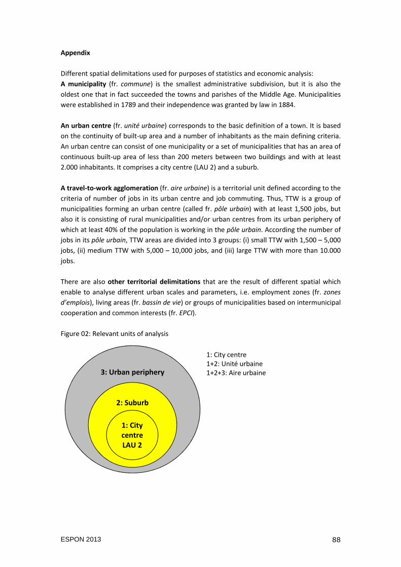
ESPON 2013 88
Appendix
Different spatial delimitations used for purposes of statistics and economic analysis:
A municipality (fr. commune) is the smallest administrative subdivision, but it is also the
oldest one that in fact succeeded the towns and parishes of the Middle Age. Municipalities
were established in 1789 and their independence was granted by law in 1884.
An urban centre (fr. unité urbaine) corresponds to the basic definition of a town. It is based
on the continuity of built-up area and a number of inhabitants as the main defining criteria.
An urban centre can consist of one municipality or a set of municipalities that has an area of
continuous built-up area of less than 200 meters between two buildings and with at least
2.000 inhabitants. It comprises a city centre (LAU 2) and a suburb.
A travel-to-work agglomeration (fr. aire urbaine) is a territorial unit defined according to the
criteria of number of jobs in its urban centre and job commuting. Thus, TTW is a group of
municipalities forming an urban centre (called fr. pôle urbain) with at least 1,500 jobs, but
also it is consisting of rural municipalities and/or urban centres from its urban periphery of
which at least 40% of the population is working in the pôle urbain. According the number of
jobs in its pôle urbain, TTW areas are divided into 3 groups: (i) small TTW with 1,500 – 5,000
jobs, (ii) medium TTW with 5,000 – 10,000 jobs, and (iii) large TTW with more than 10.000
jobs.
There are also other territorial delimitations that are the result of different spatial which
enable to analyse different urban scales and parameters, i.e. employment zones (fr. zones
d’emplois), living areas (fr. bassin de vie) or groups of municipalities based on intermunicipal
cooperation and common interests (fr. EPCI).
Figure 02: Relevant units of analysis
3: Urban periphery
2: Suburb
1: City
centre
LAU 2
1: City centre
1+2: Unité urbaine
1+2+3: Aire urbaine

ESPON 2013 89

ESPON 2013 90
The ESPON 2013 Programme is part-financed by the European Regional Development Fund, the EU Member States and the Partner States Iceland, Liechtenstein, Norway and Switzerland. It shall support policy development in relation to the aim of territorial cohesion and a harmonious development of the European territory.
ISBN