toolkit of cycling infrastructure retrofits
DESCRIPTION
Entry for Cities of Tomorrow Competition, project 80969.TRANSCRIPT
TOOLKIT OF CYCLING INFRASTRUCTURE RETROFITS:STRATEGIC SOLUTIONS FOR GTHA CITIES
PREPARED FOR: CITIES OF TOMORROW COMPETITIONDATE: UPDATED JANUARY 15, 2016ENTRY ID: 80969

ENTRY ID: 809692 /
Word count: 2,200
ENTRY ID: 80969 / �
CONTENTS
EXECUTIVE SUMMARY 4
BACKGROUND 6
CHALLENGES AND OPPORTUNITIES 8
PROJECT DESCRIPTION 10
PROPOSED APPLICATION OF TOOLKIT_SORAUREN RAILPATH RING 16
FINANCIAL CONSIDERATIONS 2�
CONCLUSION 27
APPENDIX 1_WORKS CONSULTED 28
APPENDIX 2_MAPS OF STRATEGIC CYCLING INFRASTRUCTURE RETROFIT OPPORTUNITIES IN SAMPLE GTHA REGIONS 29

ENTRY ID: 809694 /
EXECUTIVE SUMMARYExpanding cycling infrastructure in Ontario municipalities is imperative in order to reap environmental, economic and health benefits. However, due to political and fiscal challenges and geographical realities, it is difficult for municipalities to implement large-scale, comprehensive cycling infrastructure projects.
This submission proposes a toolkit of cycling retrofit designs adaptable to existing rail and transportation infrastructure in strategic locations. The retrofitting of underused rail, and potentially additional transit corridors, is a faster, cost-effective and nimbler approach to providing cycling infrastructure, all while connecting with the existing landscape and increasing recreational and cultural programming.
The unique design strategies proposed in the toolkit integrate cycling into the existing transportation fabric while ensuring cyclist/ pedestrian safety due to separation from vehicular traffic. Design components include:
• elevated bicycle path inserted along existing rail corridors • roundabout providing access points to cycling routes and controlling cycling speeds • cantilever bridge retrofit for existing rail or highway bridges • underpass retrofit offering active programming such as bicycle terrains, or passive programming such as rest stop amenities • elevated cycling ring offering a way of bridging railway crossings where alternate routes cannot be used and acting as a neighbourhood and tourist destination
Cycling initiatives are generally less expensive compared to other transportation investments, and this proposal’s strategic, incremental retrofit approach results in lower direct costs, and indirect financial benefits. The proposed retrofits overlap several jurisdictions, which provides exciting opportunities for cost sharing and community engagement.
Rather than solely providing basic infrastructure, the designs proposed in this toolkit create places with social, cultural and ecological relevancy.
ENTRY ID: 80969 / 5
ENTRY ID: 809696 /
BACKGROUNDThere is consensus across several levels of provincial and municipal government that expanding cycling infrastructure in Ontario municipalities is imperative in order to reap environmental, economic and health benefits. In Ontario’s Cycling Strategy document, #CycleOn, the following five strategic priorities are outlined:
• design healthy, active and prosperous communities • improve cycling infrastructure • make highways and streets safer • promote cycling awareness and behavioural shifts • increase cycling tourism opportunities
The #CycleOn document goes on to list the various personal, societal and economic benefits that could potentially be experienced with an increase in cycling:
• improved personal and public health, leading to decreased direct health-care expenditures • cleaner environment • increased tourism revenue
According to a 201� Ministry of Transportation Survey quoted in #CycleON, approximately 1.2 million adults in Ontario cycle daily during spring, summer and fall, and 2.8 million ride at least once a week, demonstrating that cycling is an important part of a significant number of Ontarians’ lives. Meanwhile, the popularity of various cycling groups and cycling charity events points to the social cohesiveness function that cycling can play in communities. All of which suggests that improvements to Ontario’s cycling infrastructure would be well used.
Fittingly, Strategy #2 of Metrolinx’s The Big Move is to enhance and expand active transportation in the Greater Toronto Hamilton Area (GTHA). Metrolinx estimates that 17 per cent of all trips in the GTHA are walkable (i.e. less than two kilometres in length) and 40 per cent are bikeable (i.e. less than five kilometres in length); however, walking and cycling currently account for just five per cent of all work trips and �2 per cent of all school trips. The underlying assumption is that the trips are instead taken by motorized vehicle.
ENTRY ID: 80969 / 7
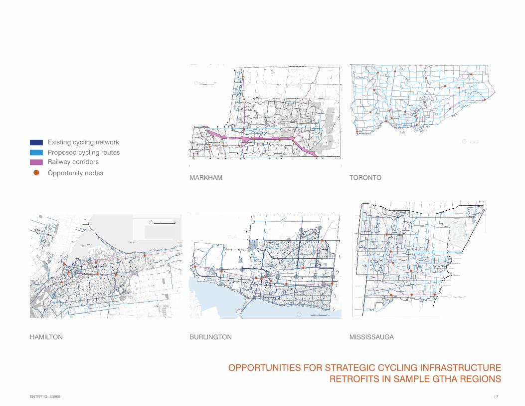
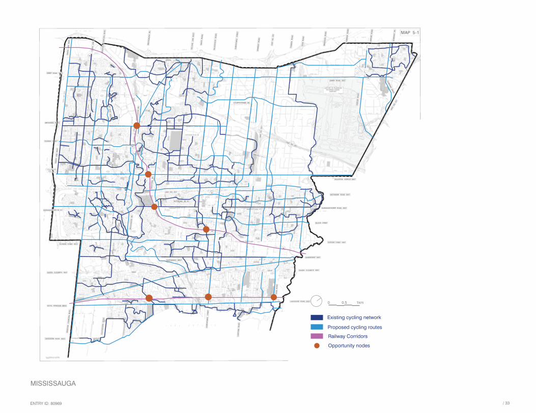
OPPORTUNITIES FOR STRATEGIC CYCLING INFRASTRUCTURE RETROFITS IN SAMPLE GTHA REGIONS
Existing cycling network
Proposed cycling routes
Railway Corridors
Opportunity nodes
0 0.5 1km
MISSISSAUGA
3 4
Existing cycling network
Proposed cycling routes 2007 - 2021
Railway Corridors
Opportunity nodes
0 0.5 1 2km
MARKHAM
Existing cycling network
Proposed cycling routes
Railway Corridors
Opportunity nodes
0 0.5 1km
TORONTO
Existing cycling network
Proposed cycling routes 2016 - 2021 and beyond
Railway Corridors
Opportunity nodes
0 0.45 0.9 1.8Km
BURLINGTON
Existing cycling network
Proposed cycling routes
Railway Corridors
Opportunity nodes
0 1 4km
HAMILTON
Existing cycling network
Proposed cycling routesRailway CorridorsOpportunity nodes
Proposed cycling routesRailway corridors
Opportunity nodes
Existing cycling network

ENTRY ID: 809698 /
CHALLENGES AND OPPORTUNITIESDue to political and fiscal challenges and geographical realities, it is difficult for municipalities to implement comprehensive cycling infrastructure projects such as those from Denmark which are most audibly praised. The Danish projects are often held as a standard to emulate; however, it may be unrealistic to replicate them in the Ontario or even the GTHA context.
City Land area (sq. km) Population density (person per sq. km)
Copenhagen 86.20 (metro area: 2,778.30) 1,850
Markham 212.58 1,419
Mississauga 292.40 2,439
Hamilton 1,371.85 525
Burlington 185.66 946
Toronto metro area: 5,905.71 945
Sources: Statistics Canada; Danmarks Statistik
While population densities of the municipalities sampled for this submission vary in comparison to that of Copenhagen, their land area is generally significantly larger. This physical fact, coupled with still strongly car-centric attitudes, implies that it may be politically and economically difficult to rationalize entirely new, dedicated cycling infrastructure.
This submission therefore proposes a toolkit of cycling retrofit designs adaptable to existing railway infrastructure in strategic locations. The retrofitting of underused rail, and potentially additional transit corridors, is a faster, cost-effective and nimbler approach to adapting existing infrastructure for cycling needs, all while connecting with the landscape and increasing recreational and cultural programming.
The Big Move Strategy #2 identifies bridges, rail corridors and missing sidewalks on major roads (as well as bridges over 400-series highways), as key barriers. This proposal considers precisely these elements as opportunity nodes that can be retrofitted to integrate into existing and planned municipal cycling and walking networks. The rail networks symbolize Southern Ontario’s thriving industrial past, in some cases still relevant; such underused post-industrial spaces can be retrofitted incrementally and strategically, facilitating in the short term the

ENTRY ID: 80969 / 9
OPPORTUNITIES FOR STRATEGIC CYCLING INFRASTRUCTURE RETROFITS IN BURLINGTON
1061 WATERDOWN ROAD 1245 PLAINS ROAD EAST GREY STREET AND BRANT STREET
QUEENSWAY DRIVE AND PLAINS ROAD EAST CUMBERLAND AVENUE AND FAIRVIEW STREET BURLOAK ROAD AND HARVEST ROAD

ENTRY ID: 8096910 /
aspirational goals for 20�� set out in #CycleOn, all while creating culturally significant places that celebrate Ontario’s historical and ecological heritage.
This proposal’s incremental, retrofit approach offers the following benefits:
• lower construction costs than for new, comprehensive infrastructure mega-projects • shorter construction times • decreased traffic disruption • facilitation of and integration into existing municipal cycling master plans, i.e., no need to overhaul existing plans • strategic, flexible and incremental selection of sites • facilitation of development density targets, i.e., no new land area is used • maintaining existing infrastructure allows for heritage preservation and cultural and historical connections to sites that are otherwise overlooked • politically and economically justifiable in areas of lower population density that do not yet directly generate ridership or tax base to cover costs • increased ecological potential, i.e., lower disruption of surrounding environment and ecological rehabilitation of retrofitted areas
PROJECT DESCRIPTIONThe design of the proposed cycling infrastructure retrofit options is based on the following considerations:
• planned and existing cycling routes in GTHA municipalities • bicycle design requirements • lack of right of way • safety • environmental impact • cost • weather and seasonality
An examination of existing transitions between roads and railways showed they are particularly ill-resolved for pedestrians and cyclists as the transitions are positioned too close to intense rail

ENTRY ID: 80969 / 11
CYCLING TOOLKIT RETROFIT COMPONENTS
SOCIAL ROUNDABOUT
ELEVATED CYCLING PATH
Potential programming
-bike repair station-interpretive signage-rest stop
Potential materials
-coloured concrete-composite wood as appropriate for speed control-rubber-solar-powered LED spotlights-native, low-maintenance planting-art installations or historical industrial machinery used as sculpture
Potential materials
-reinforced precast concrete components-steel-solar-powered LED lighting-composite wood as appropriate for speed control
ENTRY ID: 8096912 /
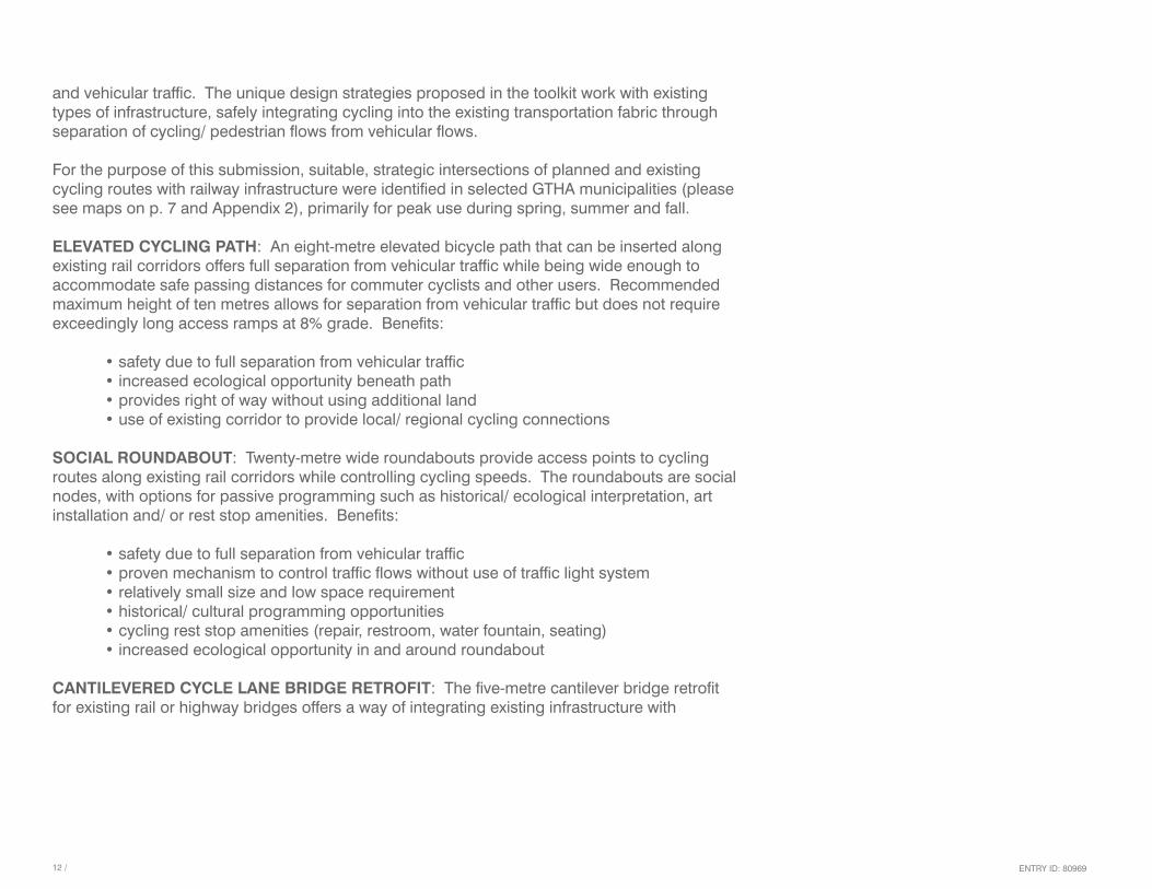
and vehicular traffic. The unique design strategies proposed in the toolkit work with existing types of infrastructure, safely integrating cycling into the existing transportation fabric through separation of cycling/ pedestrian flows from vehicular flows.
For the purpose of this submission, suitable, strategic intersections of planned and existing cycling routes with railway infrastructure were identified in selected GTHA municipalities (please see maps on p. 7 and Appendix 2), primarily for peak use during spring, summer and fall.
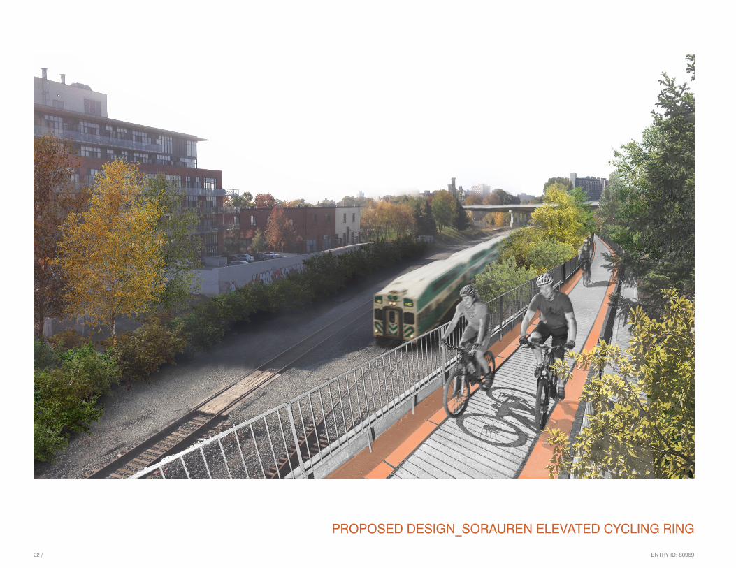
ELEVATED CYCLING PATH: An eight-metre elevated bicycle path that can be inserted along existing rail corridors offers full separation from vehicular traffic while being wide enough to accommodate safe passing distances for commuter cyclists and other users. Recommended maximum height of ten metres allows for separation from vehicular traffic but does not require exceedingly long access ramps at 8% grade. Benefits:
• safety due to full separation from vehicular traffic • increased ecological opportunity beneath path • provides right of way without using additional land • use of existing corridor to provide local/ regional cycling connections
SOCIAL ROUNDABOUT: Twenty-metre wide roundabouts provide access points to cycling routes along existing rail corridors while controlling cycling speeds. The roundabouts are social nodes, with options for passive programming such as historical/ ecological interpretation, art installation and/ or rest stop amenities. Benefits:
• safety due to full separation from vehicular traffic • proven mechanism to control traffic flows without use of traffic light system • relatively small size and low space requirement • historical/ cultural programming opportunities • cycling rest stop amenities (repair, restroom, water fountain, seating) • increased ecological opportunity in and around roundabout
CANTILEVERED CYCLE LANE BRIDGE RETROFIT: The five-metre cantilever bridge retrofit for existing rail or highway bridges offers a way of integrating existing infrastructure with

ENTRY ID: 80969 / 1�
CYCLING TOOLKIT RETROFIT COMPONENTS
ACTIVE UNDERPASS RETROFIT
CANTILEVERED CYCLE LANE BRIDGE RETROFIT
Potential programming
-bike park-bike repair station-interpretive signage highlighting a site’s historical, industrial or ecological significance-art/ light installations-rest stop
Potential materials
-reinforced precast concrete components-steel-composite wood as appropriate for speed control
Potential materials
-reinforced precast concrete components-steel-coloured concrete-solar-powered LED spotlights-rubber-art installations or historical industrial machinery used as sculpture
ENTRY ID: 8096914 /
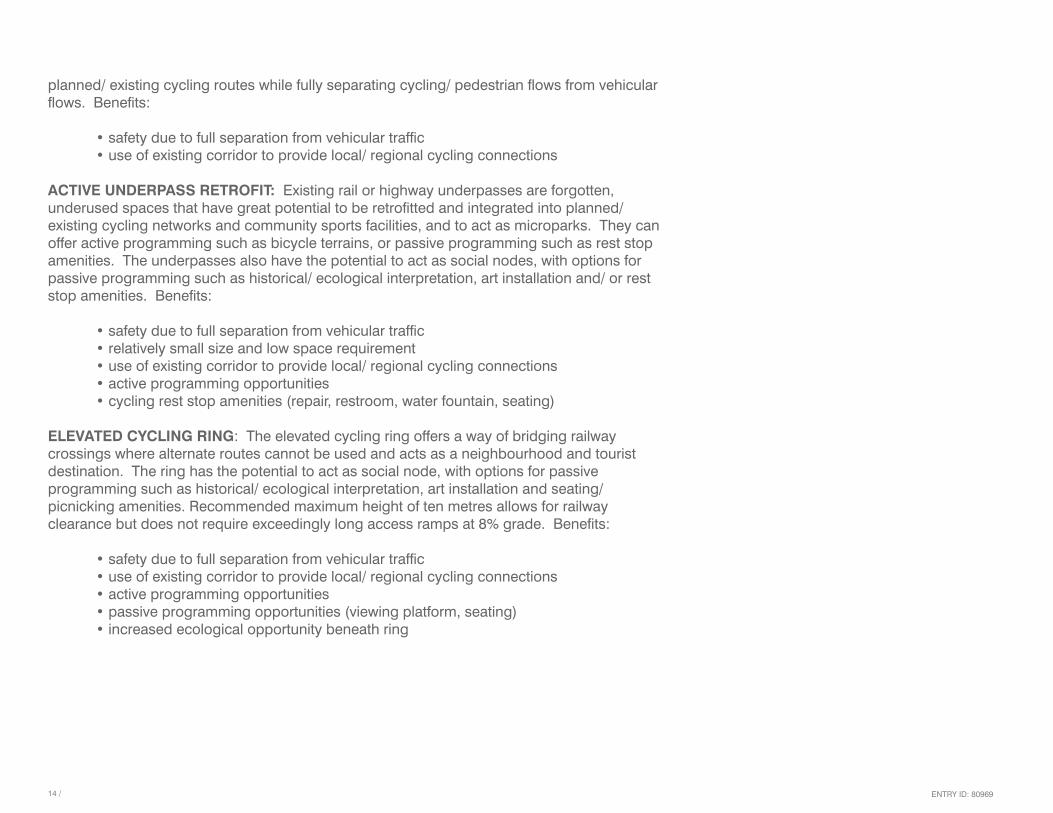
planned/ existing cycling routes while fully separating cycling/ pedestrian flows from vehicular flows. Benefits:
• safety due to full separation from vehicular traffic • use of existing corridor to provide local/ regional cycling connections
ACTIVE UNDERPASS RETROFIT: Existing rail or highway underpasses are forgotten, underused spaces that have great potential to be retrofitted and integrated into planned/ existing cycling networks and community sports facilities, and to act as microparks. They can offer active programming such as bicycle terrains, or passive programming such as rest stop amenities. The underpasses also have the potential to act as social nodes, with options for passive programming such as historical/ ecological interpretation, art installation and/ or rest stop amenities. Benefits:
• safety due to full separation from vehicular traffic • relatively small size and low space requirement • use of existing corridor to provide local/ regional cycling connections • active programming opportunities • cycling rest stop amenities (repair, restroom, water fountain, seating)
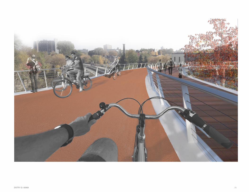
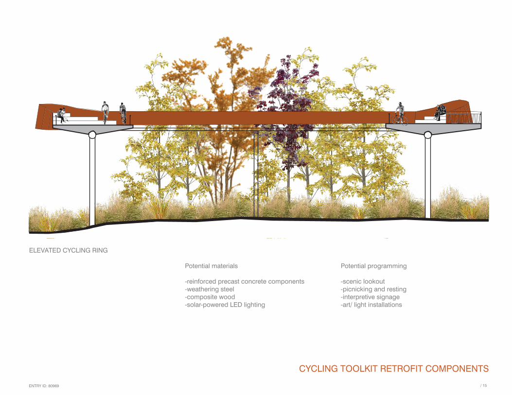
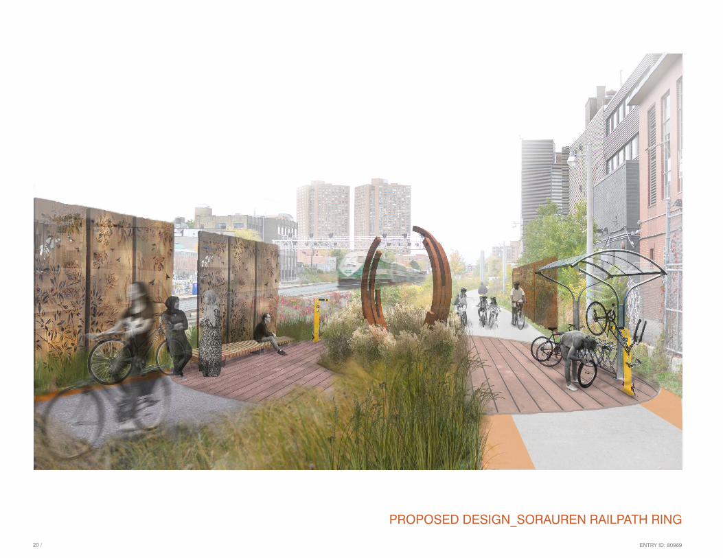
ELEVATED CYCLING RING: The elevated cycling ring offers a way of bridging railway crossings where alternate routes cannot be used and acts as a neighbourhood and tourist destination. The ring has the potential to act as social node, with options for passive programming such as historical/ ecological interpretation, art installation and seating/ picnicking amenities. Recommended maximum height of ten metres allows for railway clearance but does not require exceedingly long access ramps at 8% grade. Benefits:
• safety due to full separation from vehicular traffic • use of existing corridor to provide local/ regional cycling connections • active programming opportunities • passive programming opportunities (viewing platform, seating) • increased ecological opportunity beneath ring
ENTRY ID: 80969 / 15
CYCLING TOOLKIT RETROFIT COMPONENTS
ELEVATED CYCLING RING
Potential programming
-scenic lookout-picnicking and resting-interpretive signage-art/ light installations
Potential materials
-reinforced precast concrete components-weathering steel-composite wood-solar-powered LED lighting
ENTRY ID: 8096916 /
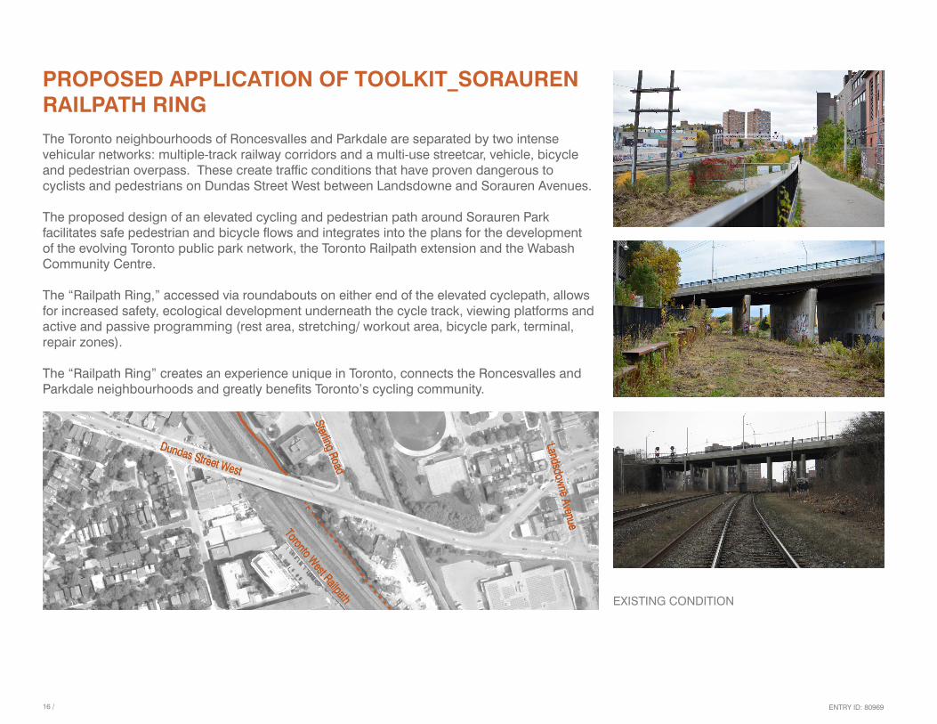
PROPOSED APPLICATION OF TOOLKIT_SORAUREN RAILPATH RINGThe Toronto neighbourhoods of Roncesvalles and Parkdale are separated by two intense vehicular networks: multiple-track railway corridors and a multi-use streetcar, vehicle, bicycle and pedestrian overpass. These create traffic conditions that have proven dangerous to cyclists and pedestrians on Dundas Street West between Landsdowne and Sorauren Avenues.
The proposed design of an elevated cycling and pedestrian path around Sorauren Park facilitates safe pedestrian and bicycle flows and integrates into the plans for the development of the evolving Toronto public park network, the Toronto Railpath extension and the Wabash Community Centre.
The “Railpath Ring,” accessed via roundabouts on either end of the elevated cyclepath, allows for increased safety, ecological development underneath the cycle track, viewing platforms and active and passive programming (rest area, stretching/ workout area, bicycle park, terminal, repair zones).
The “Railpath Ring” creates an experience unique in Toronto, connects the Roncesvalles and Parkdale neighbourhoods and greatly benefits Toronto’s cycling community.
EXISTING CONDITION

ENTRY ID: 80969 / 17
PROPOSED DESIGN_SORAUREN RAILPATH RING

ENTRY ID: 80969
1 North bicycle roundabout and access to Dundas Street West.
2 Separated bicycle path cantilevered to existing Dundas Street overpass.
� Ramp to No Frills.
4 Underpass with lit bike park.
5 Elevated bicycle path.
6 Elevated bicycle ring. Includes seating areas, play stations, viewing platforms.
7 Ramp to Wabash Avenue.
8 South bicycle roundabout and access to Wabash Avenue and planned community centre. Includes bike lock and repair station.
9 Dedicated bicycle lane using north side of Wabash Avenue.
10 Ramp to planned Toronto Railpath extension.
PROPOSED DESIGN_SORAUREN RAILPATH RING
1
24
5
6
7
�
89
10
A
A
B
B
C
C
/ 1918 /

ENTRY ID: 80969
SECTION B-B
SECTION A-A
SECTION C-C
PROPOSED DESIGN_SORAUREN RAILPATH RING
/ 1918 /
ENTRY ID: 80969
PROPOSED DESIGN_SORAUREN RAILPATH RING
/ 2120 /

ENTRY ID: 80969
PROPOSED DESIGN_SORAUREN RAILPATH RING
/ 2120 /
ENTRY ID: 80969
PROPOSED DESIGN_SORAUREN ELEVATED CYCLING RING
/ 2�22 /
ENTRY ID: 80969
FINANCIAL CONSIDERATIONSBuilding on the notion that cycling initiatives are generally less expensive compared to other transportation investments, this proposal’s strategic, incremental retrofit approach results in lower direct costs. Indirect financial benefits include:
• decreased traffic congestion • decreased health-care expenditures due to healthier communities • increased tourism spending • increased tax revenue due to increased property value near cycling routes and retrofitted areas
The proposed retrofits overlap several jurisdictions, which provides exciting opportunities for cost sharing and community engagement. In terms of implementing and evaluating the retrofits, two models that can be adapted to each project include:
• community-based working groups based on the successful model of the Friends of the West Toronto Railpath, which worked with the City of Toronto to finance and build the Railpath, in partnership with the Roncesvalles Macdonell Residents’ Association, Community Bicycle Network and Evergreen • expanding the mandate of Regional Tourism Organizations (RTO)
Financing the retrofits can come from the sources below and can be applied per the scheme in the table on page 24:
• inter-departamental municipal cost sharing among Transportation Services; Parks, Forestry and Recreation; and Economic Development and Culture • inter-ministerial provincial cost sharing among Ministries of Transportation; Economic Development, Employment and Infrastructure; and Tourism, Culture and Sport • inter-governmental agenda setting and fundraising through • Association of Municipalities of Ontario • Federation of Canadian Municipalities • Large Urban Mayors Caucus of Ontario • Big City Mayors Caucus
/ 2�22 /

ENTRY ID: 80969 / 2524 /
• federal funding through initiatives similar to the Canada 150 Community Infrastructure Program • in urban areas • sponsorship from local businesses, cycling shops • funding and fundraising from BIAs • in suburban areas • coordination and fundraising support from RTOs • fundraising from Ontario cycling associations and groups • funding transfers from The Big Move funds • funding transfers from the Metrolinx Investment Strategy generated via • fuel tax • business parking levies • development charges • high occupancy toll lanes • pay for parking at transit stations • land value capture • community fundraising and crowdfunding
Estimated costs for the proposed toolkit components are as follows:
• cantilevered cycle lane bridge retrofit: $750,000 over 4 lanes of highway (15m) • active underpass retrofit: $�50,000 • social roundabout: $�50,000 • elevated cycling path: $1,565,400 per 100m

ENTRY ID: 80969 / 2524 /
PROPOSED COST-SHARING SCHEME
Toolkit component Cost range Potential funding source
Elevated cycling path $$$$$ Multi-level government funding
Roundabout ground infrastructure $$$$$ Multi-level government funding
Roundabout cycle amenities (repair station etc.) $$$$ Community fundraising
Seating/ street furnishings $$$ Community fundraising
Interpretative signage $$ Multi-level arts/ heritage grants
Cantilever cycle lane retrofit $$$$$ Multi-level government funding
Underpass ground retrofit $$$$$ Multi-level government funding
Lighting $$ Municipal parks departmentsCommunity fundraising
Painting/ artwork $ Community groupsMulti-level arts/ heritage grants
Native plant material (from seed wherever feasible)
$ Donations from commercial/ municipal parks nurseriesHome Depot Canada Foundation
Planting/ seed collection $ Community groups
Elevated cycling ring $$$$$ Multi-level government funding
Maintenance $ Municipal parks departmentsCommunity groupsEvergreen Grant Program

ENTRY ID: 80969 / 2726 /
PROPOSED DESIGN_CANTILEVERED CYCLE PATH BRIDGE RETROFIT
ENTRY ID: 80969
CONCLUSIONThe success of redesigned, formerly overlooked post-industrial and transportation corridors such as the West Toronto Railpath or Underpass Park, also in Toronto, points to the potential of deploying similar tactics elsewhere in the GTHA as the area continues to grow and densify.
The unique design strategies included in this toolkit provide a way of quickly and efficiently integrating cycling infrastructure into the fabric of GTHA cities. Moreover, they facilitate community engagement, and provide accessibility, transportation and recreation opportunities to multiple user groups from the GTHA and beyond.
And rather than solely providing basic infrastructure over barren spaces, these designs create places with social, cultural and ecological relevancy.
/ 2726 /

ENTRY ID: 8096928 /
APPENDIX 1_WORKS CONSULTEDChicago Streets for Cycling Plan 2020http://www.chicagobikes.org/pdf/2012%20Projects/ChicagoStreetsforCycling2020.pdf
City of Toronto Cyclinghttp://www.toronto.ca/cycling
Environmental Registryhttp://www.ebr.gov.on.ca/ERS-WEB-External/displaynoticecontent.do?noticeId=MTIzMjQ2&statusId=MTg0Nzgy
Good, Better, Best; The City of Copenhagen’s Bicycle Strategy 2011-2025http://kk.sites.itera.dk/apps/kk_pub2/pdf/82�_Bg65v7UH2t.pdf
Investing in Our Region, Investing in Our Futurehttp://www.metrolinx.com/en/regionalplanning/funding/IS_Full_Report_EN.pdf
News Release: Ontario Investing $25 Million in Cycling Infrastructurehttp://news.ontario.ca/mto/en/2015/04/ontario-investing-25-million-in-cycling-infrastructure.html
Park People Toronto Alliance for Better Parkshttp://www.parkpeople.ca/resource-categories/fundinghttp://parkpeople.ca/sites/default/files/ParkPeople-MakingConnections-April2015_0.pdf
Places to Growhttp://www.placestogrow.ca/
The Big Movehttp://www.metrolinx.com/thebigmove/en/default.aspx
Toronto Centre for Active Transportationhttp://www.torontocat.ca/
University of Toronto Cycling Think and Do Tankhttp://www.torontocycling.org/
ENTRY ID: 80969 / 29
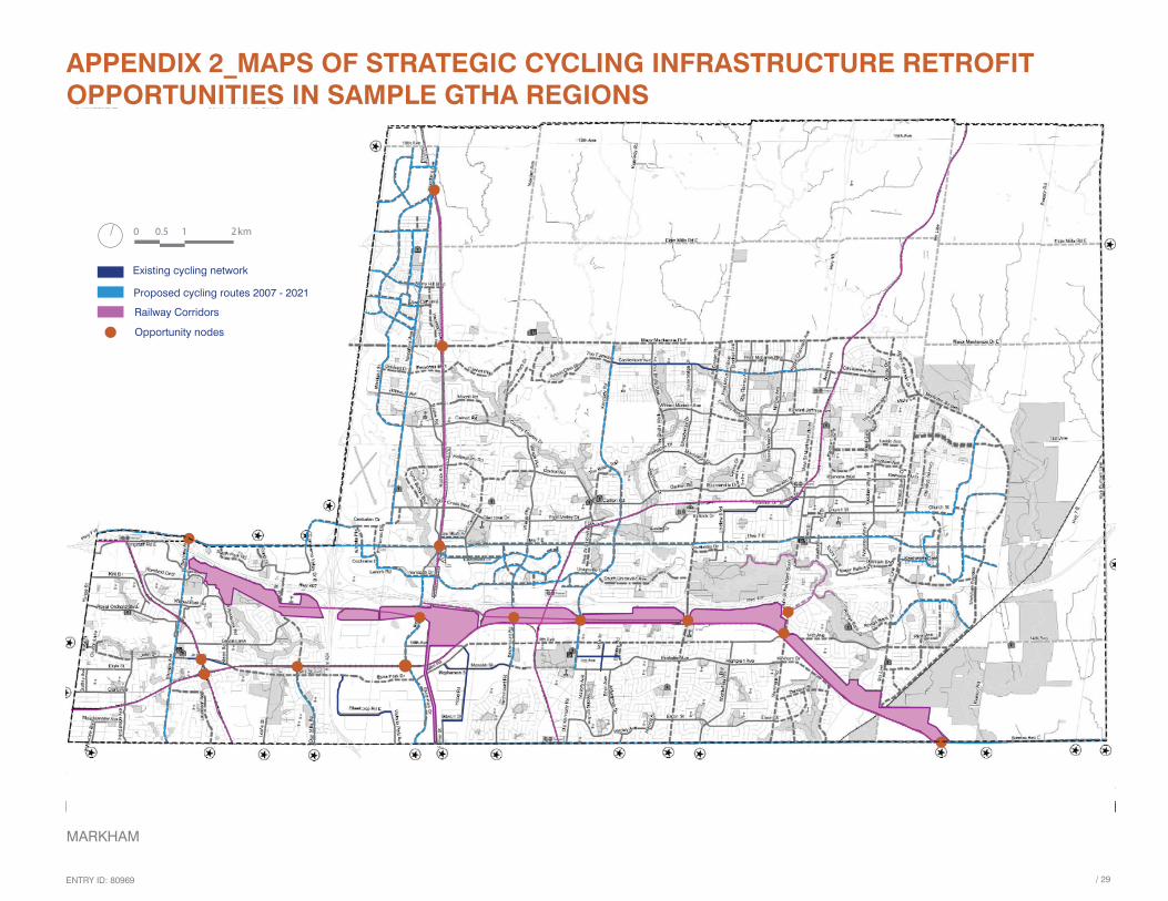
APPENDIX 2_MAPS OF STRATEGIC CYCLING INFRASTRUCTURE RETROFIT OPPORTUNITIES IN SAMPLE GTHA REGIONS
3 4
Existing cycling network
Proposed cycling routes 2007 - 2021
Railway Corridors
Opportunity nodes
0 0.5 1 2km
MARKHAM
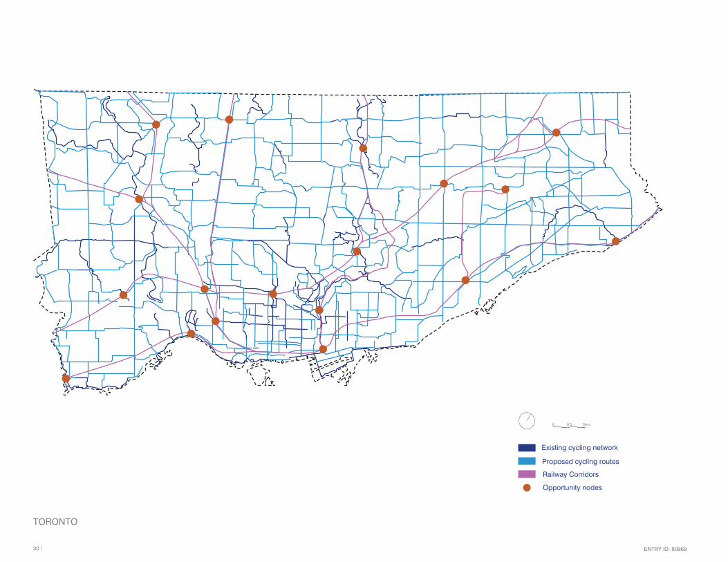
ENTRY ID: 80969�0 /
Existing cycling network
Proposed cycling routes
Railway Corridors
Opportunity nodes
0 0.5 1km
TORONTO
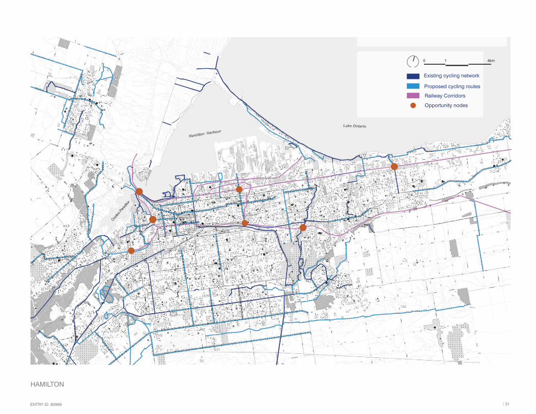
ENTRY ID: 80969 / �1
Existing cycling network
Proposed cycling routes
Railway Corridors
Opportunity nodes
0 1 4km
HAMILTON

ENTRY ID: 80969�2 /
Existing cycling network
Proposed cycling routes 2016 - 2021 and beyond
Railway Corridors
Opportunity nodes
0 0.45 0.9 1.8Km
BURLINGTON
ENTRY ID: 80969 / ��
Existing cycling network
Proposed cycling routes
Railway Corridors
Opportunity nodes
0 0.5 1km
MISSISSAUGA