tool 1: local planning system audit - amazon web … · tool 1: local planning system audit...
TRANSCRIPT
Tool 1: Local Planning System Audit | American Planning Association
www.planning.org 1
Greater Baltimore Wilderness Regional Resilience Green Infrastructure Network Local Implementation Toolkit
TOOL 1: LOCAL PLANNING SYSTEM AUDIT
American Planning Association | Greater Baltimore Wilderness Regional Resilience Green Infrastructure Network Local Implementation Toolkit
2 www.planning.org
The Greater Baltimore Wilderness Coalition Coastal Resilience ProjectThe Greater Baltimore Wilderness Coalition is a voluntary alliance of public agencies, non-governmental organizations, professional associations, and conservation coalitions. The region it spans includes the area from the Chesapeake Bay on the east to the Piedmont in the west, and from Pennsylvania in the north to the suburbs of Washington, D.C., in the south. It includes the counties of Anne Arundel, Baltimore, Carroll, Harford, Howard, Montgomery, and Prince George’s and the cities of Annapolis, Baltimore, Bowie, and others.
The goal of the resilience project is to develop a regional vision for climate resilience which will identify key green infrastructure investments across the Patapsco, Patuxent, and Gunpowder River watersheds. The Conservation Fund is leading the project team, with assistance from the American Planning Association (APA). Other team members include the U.S. Geological Survey, Center for Chesapeake Communities, and Chesapeake Conservancy.
About This ToolkitThis five-part toolkit is a companion to the Greater Baltimore Wilderness Region Green Infrastructure Identification and Ranking portal. The first tool presents a series of checklists to help planners and local officials evaluate the consistency of local plans and plan implementation methods with the opportunities for green infrastructure protection or enhancement highlighted in the portal. The second, third, and fourth tools provide guidance to help them begin the process of articulating policies and laying groundwork for action through locally adopted plans, land-use and development regulations, and public investments, respectively. The fifth, and final, tool briefly describes how three key private stakeholder groups can contribute to the implementation of the Greater Baltimore Wilderness Coalition’s Regional Resilience Green Infrastructure Network.
The toolkit was prepared by David Morley, aicp, senior research associate at APA, and Anna Read, aicp, senior program and research associate at APA. APA’s principal investigator for this project is David Rouse, faicp, APA’s managing director of Research and Advisory Services. The American Planning Association gratefully acknowledges the support of a generous grant from the National Fish and Wildlife Foundation and its Hurricane Sandy Coastal Resiliency Competitive Grant Program funded by the U.S. Department of Interior.
© December 2016 by the American Planning Association
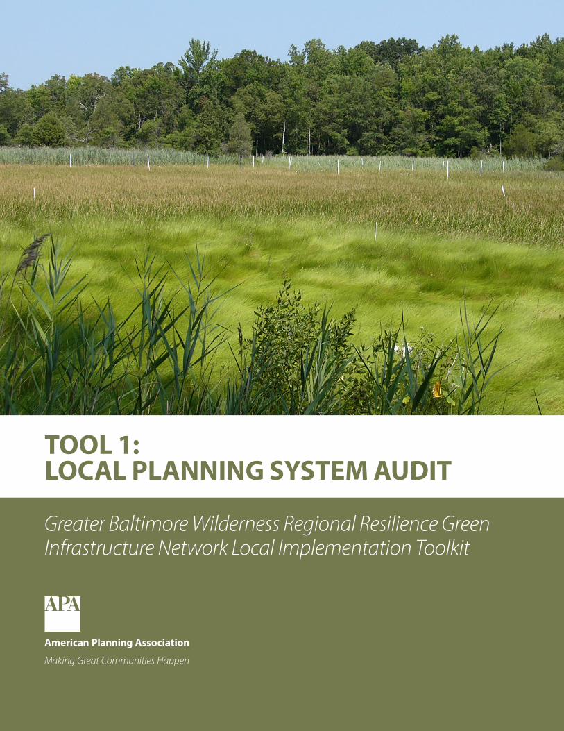
Cover image: Ted Weber, The Conservation Fund

Tool 1: Local Planning System Audit | American Planning Association
www.planning.org 3
GREEN INFRASTRUCTURE IDENTIFICATION AND RANKING PORTALThe Greater Baltimore Wilderness Region Green Infrastructure Identification and Ranking portal contains multiple data layers that collectively represent a Regional Resilience Green Infrastructure Network. This network is rooted in five green infrastructure strategies to maintain and increase regional resilience to coastal storms and other climate change impacts:
• Protect Natural Resources: Preserve, restore or enhance valuable and vulnerable land and water resources providing hazard mitigation and other co-benefits, including floodplains, wetlands, forest, stream systems, steep slopes, hydric and highly erodible soils, and important habitat areas. (NRP)
• Enhance and Restore Tree Canopy: Maintain, enhance, and restore tree canopy in urban and suburban communities to reduce stormwater runoff, ameliorate the urban heat island effect, and improve air quality. (TC)
• Implement Multi-Benefit Green Stormwater Infrastructure: Retrofit developed areas to reduce impervious surface and incorporate best management practices such as bioretention areas, green streets, and green roofs in order to reduce vulnerability to flooding and associated pollution. (GSI)
• Protect Critical Infrastructure: Use green infrastructure to buffer critical infrastructure from extreme weather impacts, including key transportation corridors, power production and transmission facilities, hospitals, and emergency management centers, water supply reservoirs, and waste water treatment facilities. (CIP)
• Defend the Coast: Preserve, restore, or enhance natural habitat and introduce nature-based practices (e.g., living shorelines) to buffer coastal areas from impacts of coastal flooding, storm surge, and sea-level rise. (CD)
This network is a potentially important tool for enhancing resilience to coastal storms and climate change throughout the Baltimore region. However, the realization of its vision depends largely on the policies and actions of the individual counties and municipalities that govern the region.
Across the U.S., each county and municipality has its own local planning system. This system is comprised of all of the local plans and associated plan implementation tools related to the growth and change of the locality over time. While state (and to some extent federal) laws do affect the scope and breadth of local policies and actions, these external limits and requirements leave most decisions related to the provision or protection of green infrastructure up to local officials.
This audit is designed to help counties and municipalities in Greater Baltimore examine the consistency of their plans, land-use regulations, and public investments with the five resilience strategies in the regional vision. It is divided into three broad sections. The first section includes a series of questions about local comprehensive, functional, and subarea plans. The second section includes questions about land-use regulations, and the third section covers public investments. After completing this audit, a locality will have a clearer picture of areas where its local planning system is consistent with regional resilience strategies, as well as opportunities to enhance that consistency.
Defining Green Infrastructure and Climate ResilienceGreen infrastructure is our natural life support system—an interconnected network of forests, wetlands, waterways, floodplains, and other natural areas; parks, greenways, and other conservation lands; forests, ranches, and farms; and other open spaces that support native species, maintain natural ecological processes, sustain air and water resources, and contribute to people’s health and quality of life. At broad scales, it includes large blocks of forest, wetlands, stream networks, and other natural systems. Meanwhile, at local scales, smaller patches may be included, and at the site scale, green infrastructure may focus on natural or semi-natural solutions to reduce stormwater runoff or heat.
For purposes of this project, we use the term climate resilience to refer to the ability to resist or mitigate the negative impacts of the changing climate in Maryland’s coastal zone, including watersheds that empty into the Chesapeake Bay. The negative effects primarily examined include rising sea levels, increased precipitation and corresponding increased stream flows and greater stormwater runoff, and coastal storm damage from wave erosion and storm surge. In looking to what services could be provided by green infrastructure—that is, natural features such as forests and wetlands as well bioengineered approaches, such as bioswales, raingardens, and green streets—the project team focused on how green infrastructure could buffer or mitigate physical damage to communities, built infrastructure such as roads and hospitals, and ecosystem features themselves. These mitigating services are examples of climate resilience. The term resilience is also used to refer to social and economic factors that can determine how well specific populations or neighborhoods can weather and recover from significant climate-caused impacts. While some social and economic factors were included in our green infrastructure analysis, these aspects were not the primary focus of the project.

American Planning Association | Greater Baltimore Wilderness Regional Resilience Green Infrastructure Network Local Implementation Toolkit
4 www.planning.org
PLANSLocal governments use plans to articulate goals and objectives (i.e., desired outcomes) and to recommend policies and actions in furtherance of those goals and objectives. There are three basic categories of local plans: comprehensive plans, functional plans, and subarea plans.
Comprehensive PlanThe comprehensive plan, sometimes referred to as the general plan or the master plan, is the foundational policy document for local governments, establishing a framework to guide decisions over the next 20 to 30 years. Comprehensive plans are named as such because they cover a broad range of topics of communitywide concern.
Audit Questions Resilience Strategies Yes No NA Comments
1. Does your jurisdiction have a locally adopted comprehensive plan? (If “No” or “NA,” skip to 10)
NRP, TC, GSI, CIP, CD
2. Does this plan address green infrastructure as a system? (If “No” or “NA,” skip to 3)
NRP, TC, GSI
a. Does it include a map or description of any of the following?
• A green infrastructure network NRP, TC
• Tree canopy TC
• Sites using low-impact development (LID) best management practices (BMPs)
GSI
• Sites suitable for LID BMPs GSI
• Ecosystem service values provided by existing natural resources
NRP, TC, GSI
b. Does it include policy recommendations that address any of the following?
• Discouraging new development in designated green infrastructure hubs and corridors
NRP
• Establishing a tree canopy goal TC
• Supporting tree planting in designated green infrastructure hubs and corridors
TC
• Targeting stormwater management efforts on sites suitable for LID BMPs
GSI
• Targeting natural resource protection efforts based on ecosystem service value
NRP
• Targeting tree planting efforts based on ecosystem service value
TC
• Targeting LID BMP implementation based on ecosystem service value
GSI
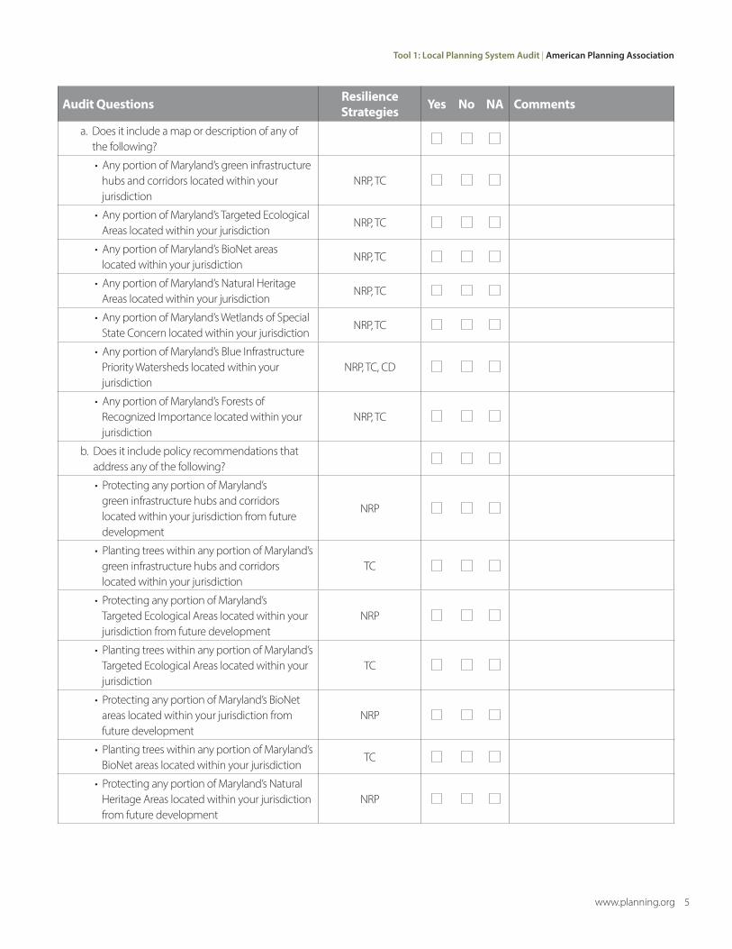
3. Does this plan address any state-designated areas of ecological significance? (If “No” or “NA,” skip to 4)
NRP, TC, CD
Tool 1: Local Planning System Audit | American Planning Association
www.planning.org 5
Audit Questions Resilience Strategies Yes No NA Comments
a. Does it include a map or description of any of the following?
• Any portion of Maryland’s green infrastructure hubs and corridors located within your jurisdiction
NRP, TC
• Any portion of Maryland’s Targeted Ecological Areas located within your jurisdiction
NRP, TC
• Any portion of Maryland’s BioNet areas located within your jurisdiction
NRP, TC
• Any portion of Maryland’s Natural Heritage Areas located within your jurisdiction
NRP, TC
• Any portion of Maryland’s Wetlands of Special State Concern located within your jurisdiction
NRP, TC
• Any portion of Maryland’s Blue Infrastructure Priority Watersheds located within your jurisdiction
NRP, TC, CD
• Any portion of Maryland’s Forests of Recognized Importance located within your jurisdiction
NRP, TC
b. Does it include policy recommendations that address any of the following?
• Protecting any portion of Maryland’s green infrastructure hubs and corridors located within your jurisdiction from future development
NRP
• Planting trees within any portion of Maryland’s green infrastructure hubs and corridors located within your jurisdiction
TC
• Protecting any portion of Maryland’s Targeted Ecological Areas located within your jurisdiction from future development
NRP
• Planting trees within any portion of Maryland’s Targeted Ecological Areas located within your jurisdiction
TC
• Protecting any portion of Maryland’s BioNet areas located within your jurisdiction from future development
NRP
• Planting trees within any portion of Maryland’s BioNet areas located within your jurisdiction
TC
• Protecting any portion of Maryland’s Natural Heritage Areas located within your jurisdiction from future development
NRP
American Planning Association | Greater Baltimore Wilderness Regional Resilience Green Infrastructure Network Local Implementation Toolkit
6 www.planning.org
Audit Questions Resilience Strategies Yes No NA Comments
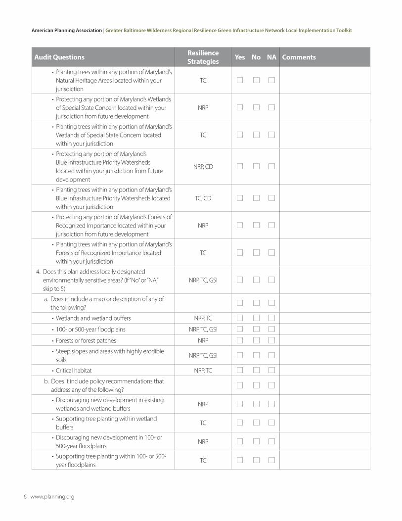
• Planting trees within any portion of Maryland’s Natural Heritage Areas located within your jurisdiction
TC
• Protecting any portion of Maryland’s Wetlands of Special State Concern located within your jurisdiction from future development
NRP
• Planting trees within any portion of Maryland’s Wetlands of Special State Concern located within your jurisdiction
TC
• Protecting any portion of Maryland’s Blue Infrastructure Priority Watersheds located within your jurisdiction from future development
NRP, CD
• Planting trees within any portion of Maryland’s Blue Infrastructure Priority Watersheds located within your jurisdiction
TC, CD
• Protecting any portion of Maryland’s Forests of Recognized Importance located within your jurisdiction from future development
NRP
• Planting trees within any portion of Maryland’s Forests of Recognized Importance located within your jurisdiction
TC
4. Does this plan address locally designated environmentally sensitive areas? (If “No” or “NA,” skip to 5)
NRP, TC, GSI
a. Does it include a map or description of any of the following?
• Wetlands and wetland buffers NRP, TC
• 100- or 500-year floodplains NRP, TC, GSI
• Forests or forest patches NRP
• Steep slopes and areas with highly erodible soils
NRP, TC, GSI
• Critical habitat NRP, TC
b. Does it include policy recommendations that address any of the following?
• Discouraging new development in existing wetlands and wetland buffers
NRP
• Supporting tree planting within wetland buffers
TC
• Discouraging new development in 100- or 500-year floodplains
NRP
• Supporting tree planting within 100- or 500-year floodplains
TC

Tool 1: Local Planning System Audit | American Planning Association
www.planning.org 7
Audit Questions Resilience Strategies Yes No NA Comments
• Targeting LID BMP implementation in 100- or 500-year floodplains
GSI
• Discouraging development in forested areas NRP
• Discouraging development on steep slopes and areas with highly erodible soils
NRP
• Supporting tree planting on steep slopes and within areas with highly erodible soils
TC
• Targeting LID BMP implementation on steep slopes and in areas with highly erodible soils
GSI
• Discouraging development in critical habitat areas
NRP
• Supporting tree planting in critical habitat areas
TC
5. Does this plan address watershed conditions? (If “No” or “NA,” skip to 6)
NRP, TC, GSI
a. Does it include a map or description of any of the following?
• Forest cover by watershed NRP
• Tree canopy by watershed TC
• Impervious cover by watershed NRP, TC, GSI
• Existing LID BMPs by watershed GSI
• Nutrient loading by watershed GSI
b. Does it include any policy recommendations that address any of the following?
• Protecting existing forest cover within each watershed
NRP
• Discouraging additional impervious cover within watersheds with less than 20% impervious cover
NRP
• Supporting tree planting within watersheds with 5 to 20% impervious cover
TC
• Supporting tree planting within watersheds with more than 20% impervious cover
TC
• Targeting LID BMP implementation within watersheds with more than 5% impervious cover
GSI
• Targeting LID BMP implementation within watersheds that exceed permissible nutrient-loading levels
GSI
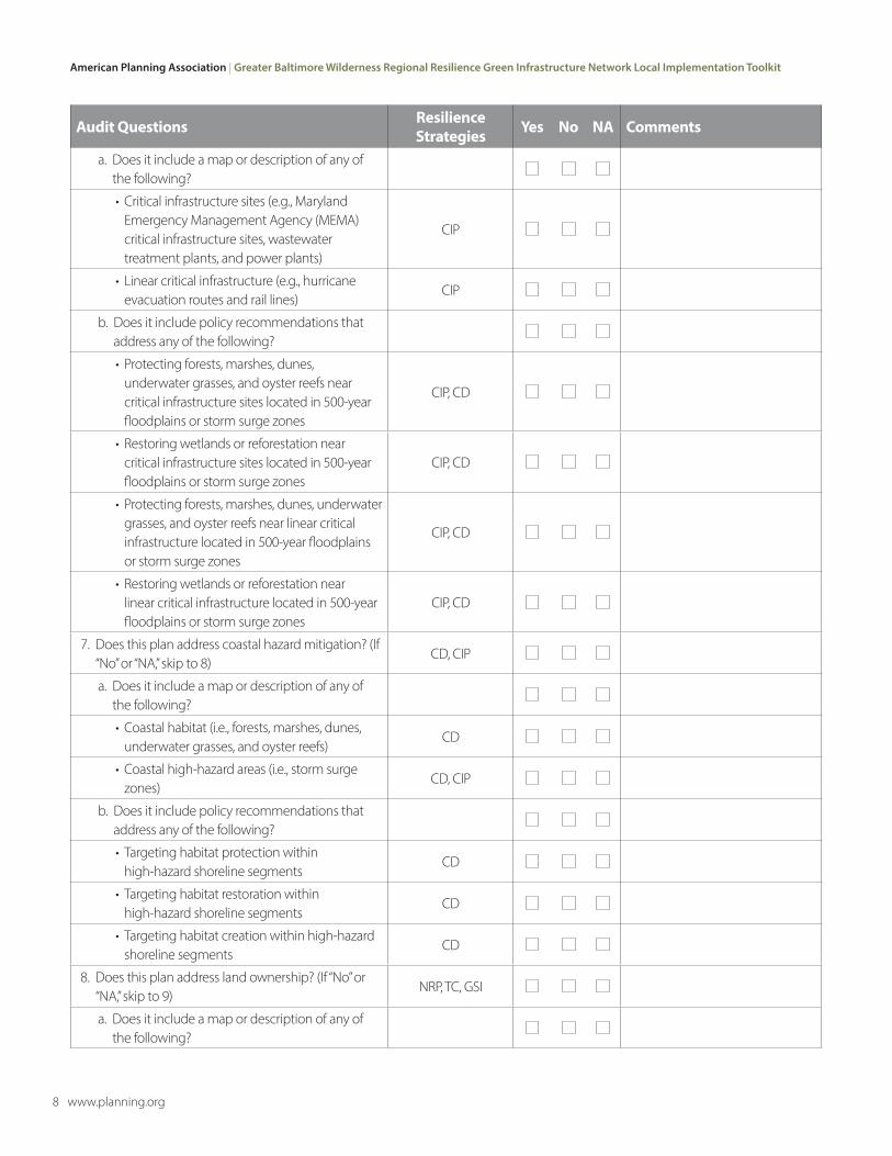
6. Does this plan address critical infrastructure? (If “No” or “NA,” skip to 7)
CIP
American Planning Association | Greater Baltimore Wilderness Regional Resilience Green Infrastructure Network Local Implementation Toolkit
8 www.planning.org
Audit Questions Resilience Strategies Yes No NA Comments
a. Does it include a map or description of any of the following?
• Critical infrastructure sites (e.g., Maryland Emergency Management Agency (MEMA) critical infrastructure sites, wastewater treatment plants, and power plants)
CIP
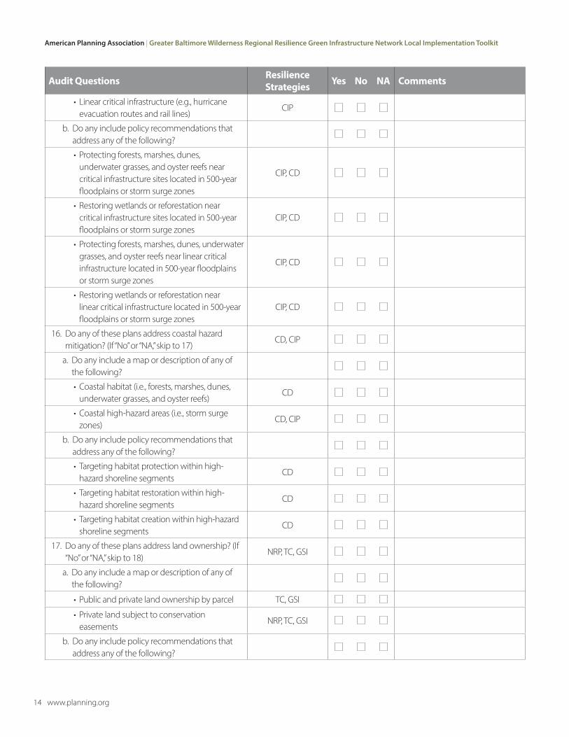
• Linear critical infrastructure (e.g., hurricane evacuation routes and rail lines)
CIP
b. Does it include policy recommendations that address any of the following?
• Protecting forests, marshes, dunes, underwater grasses, and oyster reefs near critical infrastructure sites located in 500-year floodplains or storm surge zones
CIP, CD
• Restoring wetlands or reforestation near critical infrastructure sites located in 500-year floodplains or storm surge zones
CIP, CD
• Protecting forests, marshes, dunes, underwater grasses, and oyster reefs near linear critical infrastructure located in 500-year floodplains or storm surge zones
CIP, CD
• Restoring wetlands or reforestation near linear critical infrastructure located in 500-year floodplains or storm surge zones
CIP, CD
7. Does this plan address coastal hazard mitigation? (If “No” or “NA,” skip to 8)
CD, CIP
a. Does it include a map or description of any of the following?
• Coastal habitat (i.e., forests, marshes, dunes, underwater grasses, and oyster reefs)
CD
• Coastal high-hazard areas (i.e., storm surge zones)
CD, CIP
b. Does it include policy recommendations that address any of the following?
• Targeting habitat protection within high-hazard shoreline segments
CD
• Targeting habitat restoration within high-hazard shoreline segments
CD
• Targeting habitat creation within high-hazard shoreline segments
CD
8. Does this plan address land ownership? (If “No” or “NA,” skip to 9)
NRP, TC, GSI
a. Does it include a map or description of any of the following?

Tool 1: Local Planning System Audit | American Planning Association
www.planning.org 9
Audit Questions Resilience Strategies Yes No NA Comments
• Public and private land ownership by parcel TC, GSI
• Private land subject to conservation easements
NRP, TC, GSI
b. Does it include policy recommendations that address any of the following?
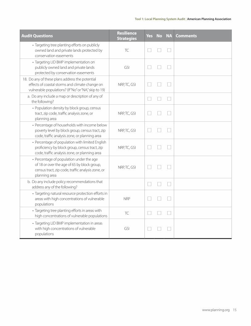
• Targeting tree planting efforts on publicly owned land and private lands protected by conservation easements
TC
• Targeting LID BMP implementation on publicly owned land and private lands protected by conservation easements
GSI
9. Does this plan address the potential effects of coastal storms and climate change on vulnerable populations? (If “No” or “NA,” skip to 10)
NRP, TC, GSI
a. Does it include a map or description of any of the following?
• Population density by block group, census tract, zip code, traffic analysis zone, or planning area
NRP, TC, GSI
• Percentage of households with income below poverty level by block group, census tract, zip code, traffic analysis zone, or planning area
NRP, TC, GSI
• Percentage of population with limited English proficiency by block group, census tract, zip code, traffic analysis zone, or planning area
NRP, TC, GSI
• Percentage of population under the age of 18 or over the age of 65 by block group, census tract, zip code, traffic analysis zone, or planning area
NRP, TC, GSI
b. Does it include policy recommendations that address any of the following?
• Targeting natural resource protection efforts in areas with high concentrations of vulnerable populations
NRP
• Targeting tree planting efforts in areas with high concentrations of vulnerable populations
TC
• Targeting LID BMP implementation in areas with high concentrations of vulnerable populations
GSI
American Planning Association | Greater Baltimore Wilderness Regional Resilience Green Infrastructure Network Local Implementation Toolkit
10 www.planning.org
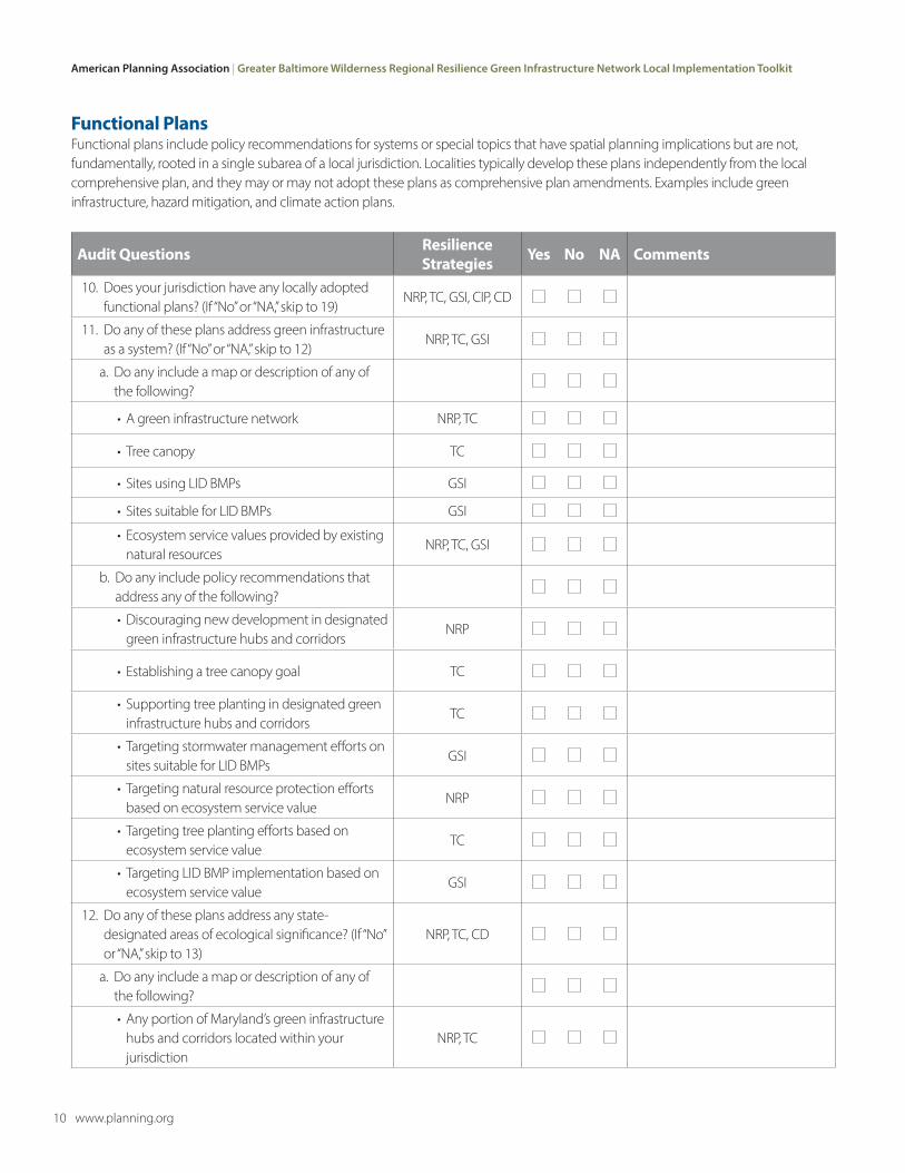
Functional PlansFunctional plans include policy recommendations for systems or special topics that have spatial planning implications but are not, fundamentally, rooted in a single subarea of a local jurisdiction. Localities typically develop these plans independently from the local comprehensive plan, and they may or may not adopt these plans as comprehensive plan amendments. Examples include green infrastructure, hazard mitigation, and climate action plans.
Audit Questions Resilience Strategies Yes No NA Comments
10. Does your jurisdiction have any locally adopted functional plans? (If “No” or “NA,” skip to 19)
NRP, TC, GSI, CIP, CD
11. Do any of these plans address green infrastructure as a system? (If “No” or “NA,” skip to 12)
NRP, TC, GSI
a. Do any include a map or description of any of the following?
• A green infrastructure network NRP, TC
• Tree canopy TC
• Sites using LID BMPs GSI
• Sites suitable for LID BMPs GSI
• Ecosystem service values provided by existing natural resources
NRP, TC, GSI
b. Do any include policy recommendations that address any of the following?
• Discouraging new development in designated green infrastructure hubs and corridors
NRP
• Establishing a tree canopy goal TC
• Supporting tree planting in designated green infrastructure hubs and corridors
TC
• Targeting stormwater management efforts on sites suitable for LID BMPs
GSI
• Targeting natural resource protection efforts based on ecosystem service value
NRP
• Targeting tree planting efforts based on ecosystem service value
TC
• Targeting LID BMP implementation based on ecosystem service value
GSI
12. Do any of these plans address any state-designated areas of ecological significance? (If “No” or “NA,” skip to 13)
NRP, TC, CD
a. Do any include a map or description of any of the following?
• Any portion of Maryland’s green infrastructure hubs and corridors located within your jurisdiction
NRP, TC

Tool 1: Local Planning System Audit | American Planning Association
www.planning.org 11
Audit Questions Resilience Strategies Yes No NA Comments
• Any portion of Maryland’s Targeted Ecological Areas located within your jurisdiction
NRP, TC
• Any portion of Maryland’s BioNet areas located within your jurisdiction
NRP, TC
• Any portion of Maryland’s Natural Heritage Areas located within your jurisdiction
NRP, TC
• Any portion of Maryland’s Wetlands of Special State Concern located within your jurisdiction
NRP, TC
• Any portion of Maryland’s Blue Infrastructure Priority Watersheds located within your jurisdiction
NRP, TC, CD
• Any portion of Maryland’s Forests of Recognized Importance located within your jurisdiction
NRP, TC
b. Do any include policy recommendations that address any of the following?
• Protecting any portion of Maryland’s green infrastructure hubs and corridors located within your jurisdiction from future development
NRP
• Planting trees within any portion of Maryland’s green infrastructure hubs and corridors located within your jurisdiction
TC
• Protecting any portion of Maryland’s Targeted Ecological Areas located within your jurisdiction from future development
NRP
• Planting trees within any portion of Maryland’s Targeted Ecological Areas located within your jurisdiction
TC
• Protecting any portion of Maryland’s BioNet areas located within your jurisdiction from future development
NRP
• Planting trees within any portion of Maryland’s BioNet areas located within your jurisdiction
TC
• Protecting any portion of Maryland’s Natural Heritage Areas located within your jurisdiction from future development
NRP
• Planting trees within any portion of Maryland’s Natural Heritage Areas located within your jurisdiction
TC
• Protecting any portion of Maryland’s Wetlands of Special State Concern located within your jurisdiction from future development
NRP

American Planning Association | Greater Baltimore Wilderness Regional Resilience Green Infrastructure Network Local Implementation Toolkit
12 www.planning.org
Audit Questions Resilience Strategies Yes No NA Comments
• Planting trees within any portion of Maryland’s Wetlands of Special State Concern located within your jurisdiction
TC
• Protecting any portion of Maryland’s Blue Infrastructure Priority Watersheds located within your jurisdiction from future development
NRP, CD
• Planting trees within any portion of Maryland’s Blue Infrastructure Priority Watersheds located within your jurisdiction
TC, CD
• Protecting any portion of Maryland’s Forests of Recognized Importance located within your jurisdiction from future development
NRP
• Planting trees within any portion of Maryland’s Forests of Recognized Importance located within your jurisdiction
TC
13. Do any of these plans address locally designated environmentally sensitive areas? (If “No” or “NA,” skip to 14)
NRP, TC, GSI
a. Do any include a map or description of any of the following?
• Wetlands and wetland buffers NRP, TC
• 100- or 500-year floodplains NRP, TC, GSI
• Forests or forest patches NRP
• Steep slopes and areas with highly erodible soils
NRP, TC, GSI
• Critical habitat NRP, TC
b. Do any include policy recommendations that address any of the following?
• Discouraging new development in existing wetlands and wetland buffers
NRP
• Supporting tree planting within wetland buffers
TC
• Discouraging new development in 100- or 500-year floodplains
NRP
• Supporting tree planting within 100- or 500-year floodplains
TC
• Targeting LID BMP implementation in 100- or 500-year floodplains
GSI
• Discouraging development in forested areas NRP
• Discouraging development on steep slopes and areas with highly erodible soils
NRP

Tool 1: Local Planning System Audit | American Planning Association
www.planning.org 13
Audit Questions Resilience Strategies Yes No NA Comments
• Supporting tree planting on steep slopes and within areas with highly erodible soils
TC
• Targeting LID BMP implementation on steep slopes and in areas with highly erodible soils
GSI
• Discouraging development in critical habitat areas
NRP
• Supporting tree planting in critical habitat areas
TC
14. Do any of these plans address watershed conditions? (If “No” or “NA,” skip to 15)
NRP, TC, GSI
a. Do any include a map or description of any of the following?
• Forest cover by watershed NRP
• Tree canopy by watershed TC
• Impervious cover by watershed NRP, TC, GSI
• Existing LID BMPs by watershed GSI
• Nutrient loading by watershed GSI
b. Do any include any policy recommendations that address any of the following?
• Protecting existing forest cover within each watershed
NRP
• Discouraging additional impervious cover within watersheds with less than 20% impervious cover
NRP
• Supporting tree planting within watersheds with 5 to 20% impervious cover
TC
• Supporting tree planting within watersheds with more than 20% impervious cover
TC
• Targeting LID BMP implementation within watersheds with more than 5% impervious cover
GSI
• Targeting LID BMP implementation within watersheds that exceed permissible nutrient-loading levels
GSI
15. Do any of these plans address critical infrastructure? (If “No” or “NA,” skip to 16)
CIP
a. Do any include a map or description of any of the following?
• Critical infrastructure sites (e.g., MEMA critical infrastructure sites, wastewater treatment plants, and power plants)
CIP
American Planning Association | Greater Baltimore Wilderness Regional Resilience Green Infrastructure Network Local Implementation Toolkit
14 www.planning.org
Audit Questions Resilience Strategies Yes No NA Comments
• Linear critical infrastructure (e.g., hurricane evacuation routes and rail lines)
CIP
b. Do any include policy recommendations that address any of the following?
• Protecting forests, marshes, dunes, underwater grasses, and oyster reefs near critical infrastructure sites located in 500-year floodplains or storm surge zones
CIP, CD
• Restoring wetlands or reforestation near critical infrastructure sites located in 500-year floodplains or storm surge zones
CIP, CD
• Protecting forests, marshes, dunes, underwater grasses, and oyster reefs near linear critical infrastructure located in 500-year floodplains or storm surge zones
CIP, CD
• Restoring wetlands or reforestation near linear critical infrastructure located in 500-year floodplains or storm surge zones
CIP, CD
16. Do any of these plans address coastal hazard mitigation? (If “No” or “NA,” skip to 17)
CD, CIP
a. Do any include a map or description of any of the following?
• Coastal habitat (i.e., forests, marshes, dunes, underwater grasses, and oyster reefs)
CD
• Coastal high-hazard areas (i.e., storm surge zones)
CD, CIP
b. Do any include policy recommendations that address any of the following?
• Targeting habitat protection within high- hazard shoreline segments
CD
• Targeting habitat restoration within high- hazard shoreline segments
CD
• Targeting habitat creation within high-hazard shoreline segments
CD
17. Do any of these plans address land ownership? (If “No” or “NA,” skip to 18)
NRP, TC, GSI
a. Do any include a map or description of any of the following?
• Public and private land ownership by parcel TC, GSI
• Private land subject to conservation easements
NRP, TC, GSI
b. Do any include policy recommendations that address any of the following?
Tool 1: Local Planning System Audit | American Planning Association
www.planning.org 15
Audit Questions Resilience Strategies Yes No NA Comments
• Targeting tree planting efforts on publicly owned land and private lands protected by conservation easements
TC
• Targeting LID BMP implementation on publicly owned land and private lands protected by conservation easements
GSI
18. Do any of these plans address the potential effects of coastal storms and climate change on vulnerable populations? (If “No” or “NA,” skip to 19)
NRP, TC, GSI
a. Do any include a map or description of any of the following?
• Population density by block group, census tract, zip code, traffic analysis zone, or planning area
NRP, TC, GSI
• Percentage of households with income below poverty level by block group, census tract, zip code, traffic analysis zone, or planning area
NRP, TC, GSI
• Percentage of population with limited English proficiency by block group, census tract, zip code, traffic analysis zone, or planning area
NRP, TC, GSI
• Percentage of population under the age of 18 or over the age of 65 by block group, census tract, zip code, traffic analysis zone, or planning area
NRP, TC, GSI
b. Do any include policy recommendations that address any of the following?
• Targeting natural resource protection efforts in areas with high concentrations of vulnerable populations
NRP
• Targeting tree planting efforts in areas with high concentrations of vulnerable populations
TC
• Targeting LID BMP implementation in areas with high concentrations of vulnerable populations
GSI
American Planning Association | Greater Baltimore Wilderness Regional Resilience Green Infrastructure Network Local Implementation Toolkit
16 www.planning.org
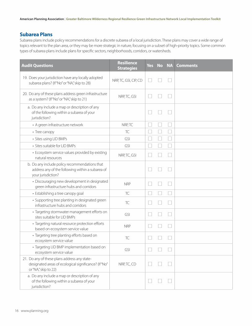
Subarea PlansSubarea plans include policy recommendations for a discrete subarea of a local jurisdiction. These plans may cover a wide range of topics relevant to the plan area, or they may be more strategic in nature, focusing on a subset of high-priority topics. Some common types of subarea plans include plans for specific sectors, neighborhoods, corridors, or watersheds.
Audit Questions Resilience Strategies Yes No NA Comments
19. Does your jurisdiction have any locally adopted subarea plans? (If “No” or “NA,” skip to 28)
NRP, TC, GSI, CIP, CD
20. Do any of these plans address green infrastructure as a system? (If “No” or “NA,” skip to 21)
NRP, TC, GSI
a. Do any include a map or description of any of the following within a subarea of your jurisdiction?
• A green infrastructure network NRP, TC
• Tree canopy TC
• Sites using LID BMPs GSI
• Sites suitable for LID BMPs GSI
• Ecosystem service values provided by existing natural resources
NRP, TC, GSI
b. Do any include policy recommendations that address any of the following within a subarea of your jurisdiction?
• Discouraging new development in designated green infrastructure hubs and corridors
NRP
• Establishing a tree canopy goal TC
• Supporting tree planting in designated green infrastructure hubs and corridors
TC
• Targeting stormwater management efforts on sites suitable for LID BMPs
GSI
• Targeting natural resource protection efforts based on ecosystem service value
NRP
• Targeting tree planting efforts based on ecosystem service value
TC
• Targeting LID BMP implementation based on ecosystem service value
GSI
21. Do any of these plans address any state-designated areas of ecological significance? (If “No” or “NA,” skip to 22)
NRP, TC, CD
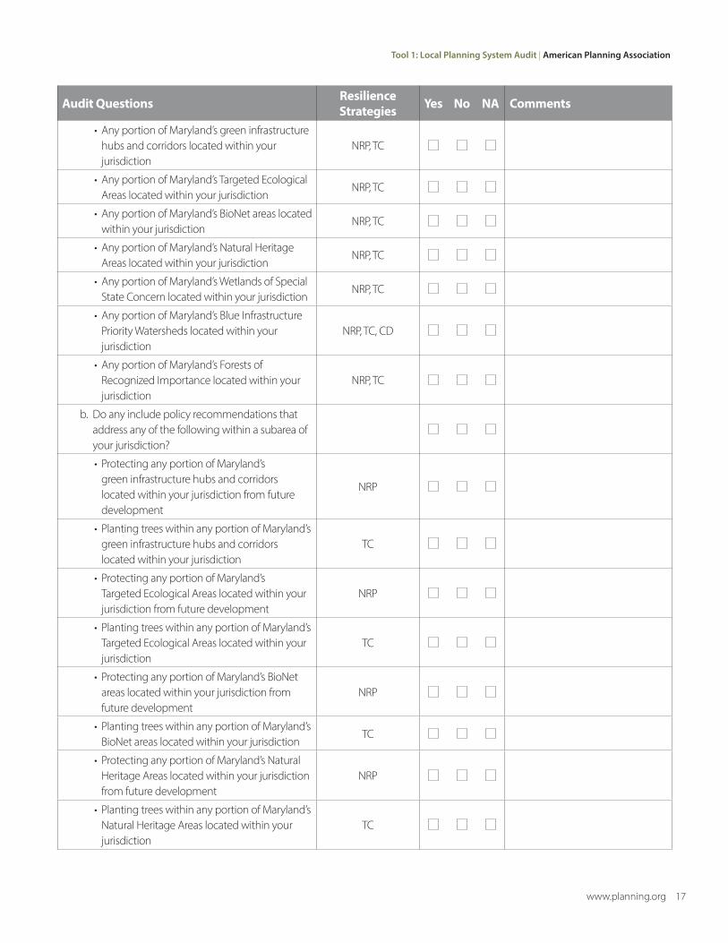
a. Do any include a map or description of any of the following within a subarea of your jurisdiction?
Tool 1: Local Planning System Audit | American Planning Association
www.planning.org 17
Audit Questions Resilience Strategies Yes No NA Comments
• Any portion of Maryland’s green infrastructure hubs and corridors located within your jurisdiction
NRP, TC
• Any portion of Maryland’s Targeted Ecological Areas located within your jurisdiction
NRP, TC
• Any portion of Maryland’s BioNet areas located within your jurisdiction
NRP, TC
• Any portion of Maryland’s Natural Heritage Areas located within your jurisdiction
NRP, TC
• Any portion of Maryland’s Wetlands of Special State Concern located within your jurisdiction
NRP, TC
• Any portion of Maryland’s Blue Infrastructure Priority Watersheds located within your jurisdiction
NRP, TC, CD
• Any portion of Maryland’s Forests of Recognized Importance located within your jurisdiction
NRP, TC
b. Do any include policy recommendations that address any of the following within a subarea of your jurisdiction?
• Protecting any portion of Maryland’s green infrastructure hubs and corridors located within your jurisdiction from future development
NRP
• Planting trees within any portion of Maryland’s green infrastructure hubs and corridors located within your jurisdiction
TC
• Protecting any portion of Maryland’s Targeted Ecological Areas located within your jurisdiction from future development
NRP
• Planting trees within any portion of Maryland’s Targeted Ecological Areas located within your jurisdiction
TC
• Protecting any portion of Maryland’s BioNet areas located within your jurisdiction from future development
NRP
• Planting trees within any portion of Maryland’s BioNet areas located within your jurisdiction
TC
• Protecting any portion of Maryland’s Natural Heritage Areas located within your jurisdiction from future development
NRP
• Planting trees within any portion of Maryland’s Natural Heritage Areas located within your jurisdiction
TC
American Planning Association | Greater Baltimore Wilderness Regional Resilience Green Infrastructure Network Local Implementation Toolkit
18 www.planning.org
Audit Questions Resilience Strategies Yes No NA Comments
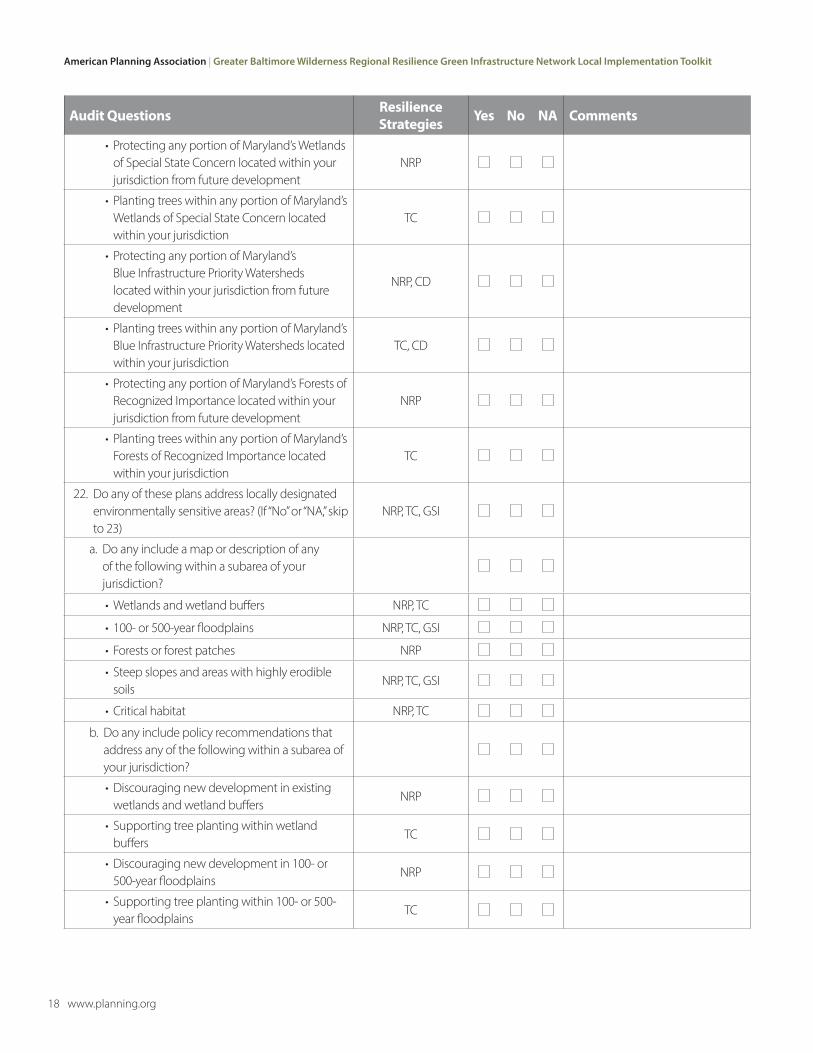
• Protecting any portion of Maryland’s Wetlands of Special State Concern located within your jurisdiction from future development
NRP
• Planting trees within any portion of Maryland’s Wetlands of Special State Concern located within your jurisdiction
TC
• Protecting any portion of Maryland’s Blue Infrastructure Priority Watersheds located within your jurisdiction from future development
NRP, CD
• Planting trees within any portion of Maryland’s Blue Infrastructure Priority Watersheds located within your jurisdiction
TC, CD
• Protecting any portion of Maryland’s Forests of Recognized Importance located within your jurisdiction from future development
NRP
• Planting trees within any portion of Maryland’s Forests of Recognized Importance located within your jurisdiction
TC
22. Do any of these plans address locally designated environmentally sensitive areas? (If “No” or “NA,” skip to 23)
NRP, TC, GSI
a. Do any include a map or description of any of the following within a subarea of your jurisdiction?
• Wetlands and wetland buffers NRP, TC
• 100- or 500-year floodplains NRP, TC, GSI
• Forests or forest patches NRP
• Steep slopes and areas with highly erodible soils
NRP, TC, GSI
• Critical habitat NRP, TC
b. Do any include policy recommendations that address any of the following within a subarea of your jurisdiction?
• Discouraging new development in existing wetlands and wetland buffers
NRP
• Supporting tree planting within wetland buffers
TC
• Discouraging new development in 100- or 500-year floodplains
NRP
• Supporting tree planting within 100- or 500-year floodplains
TC
Tool 1: Local Planning System Audit | American Planning Association
www.planning.org 19
Audit Questions Resilience Strategies Yes No NA Comments
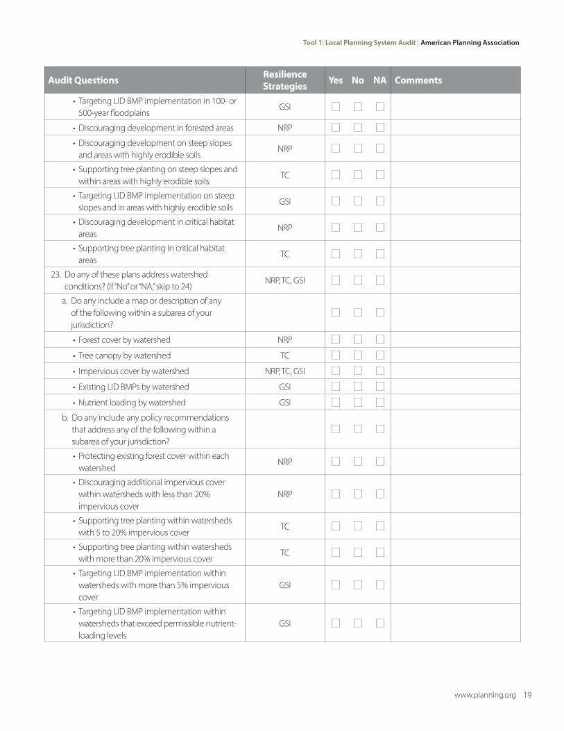
• Targeting LID BMP implementation in 100- or 500-year floodplains
GSI
• Discouraging development in forested areas NRP
• Discouraging development on steep slopes and areas with highly erodible soils
NRP
• Supporting tree planting on steep slopes and within areas with highly erodible soils
TC
• Targeting LID BMP implementation on steep slopes and in areas with highly erodible soils
GSI
• Discouraging development in critical habitat areas
NRP
• Supporting tree planting in critical habitat areas
TC
23. Do any of these plans address watershed conditions? (If “No” or “NA,” skip to 24)
NRP, TC, GSI
a. Do any include a map or description of any of the following within a subarea of your jurisdiction?
• Forest cover by watershed NRP
• Tree canopy by watershed TC
• Impervious cover by watershed NRP, TC, GSI
• Existing LID BMPs by watershed GSI
• Nutrient loading by watershed GSI
b. Do any include any policy recommendations that address any of the following within a subarea of your jurisdiction?
• Protecting existing forest cover within each watershed
NRP
• Discouraging additional impervious cover within watersheds with less than 20% impervious cover
NRP
• Supporting tree planting within watersheds with 5 to 20% impervious cover
TC
• Supporting tree planting within watersheds with more than 20% impervious cover
TC
• Targeting LID BMP implementation within watersheds with more than 5% impervious cover
GSI
• Targeting LID BMP implementation within watersheds that exceed permissible nutrient-loading levels
GSI
American Planning Association | Greater Baltimore Wilderness Regional Resilience Green Infrastructure Network Local Implementation Toolkit
20 www.planning.org
Audit Questions Resilience Strategies Yes No NA Comments
24. Do any of these plans address critical infrastructure? (If “No” or “NA,” skip to 25)
CIP
a. Do any include a map or description of any of the following within a subarea of your jurisdiction?
• Critical infrastructure sites (e.g., MEMA critical infrastructure sites, wastewater treatment plants, and power plants)
CIP
• Linear critical infrastructure (e.g., hurricane evacuation routes and rail lines)
CIP
b. Do any include policy recommendations that address any of the following within a subarea of your jurisdiction?
• Protecting forests, marshes, dunes, underwater grasses, and oyster reefs near critical infrastructure sites located in 500-year floodplains or storm surge zones
CIP, CD
• Restoring wetlands or reforestation near critical infrastructure sites located in 500-year floodplains or storm surge zones
CIP, CD
• Protecting forests, marshes, dunes, underwater grasses, and oyster reefs near linear critical infrastructure located in 500-year floodplains or storm surge zones
CIP, CD
• Restoring wetlands or reforestation near linear critical infrastructure located in 500-year floodplains or storm surge zones
CIP, CD
25. Do any of these plans address coastal hazard mitigation? (If “No” or “NA,” skip to 26)
CD, CIP
a. Do any include a map or description of any of the following within a subarea of your jurisdiction?
• Coastal habitat (i.e., forests, marshes, dunes, underwater grasses, and oyster reefs)
CD
• Coastal high-hazard areas (i.e., storm surge zones)
CD, CIP
b. Do any include policy recommendations that address any of the following within a subarea of your jurisdiction?
• Targeting habitat protection within high- hazard shoreline segments
CD
• Targeting habitat restoration within high- hazard shoreline segments
CD
Tool 1: Local Planning System Audit | American Planning Association
www.planning.org 21
Audit Questions Resilience Strategies Yes No NA Comments
• Targeting habitat creation within high-hazard shoreline segments
CD
26. Do any of these plans address land ownership? (If “No” or “NA,” skip to 27)
NRP, TC, GSI
a. Do any include a map or description of any of the following within a subarea of your jurisdiction?
• Public and private land ownership by parcel TC, GSI
• Private land subject to conservation easements
NRP, TC, GSI
b. Do any include policy recommendations that address any of the following within a subarea of your jurisdiction?
• Targeting tree-planting efforts on publicly owned land and private lands protected by conservation easements
TC
• Targeting LID BMP implementation on publicly owned land and private lands protected by conservation easements
GSI
27. Do any of these plans address the potential effects of coastal storms and climate change on vulnerable populations? (If “No” or “NA,” skip to 28)
NRP, TC, GSI
a. Do any include a map or description of any of the following within a subarea of your jurisdiction?
• Population density by block group, census tract, zip code, traffic analysis zone, or planning area
NRP, TC, GSI
• Percentage of households with income below poverty level by block group, census tract, zip code, traffic analysis zone, or planning area
NRP, TC, GSI
• Percentage of population with limited English proficiency by block group, census tract, zip code, traffic analysis zone, or planning area
NRP, TC, GSI
• Percentage of population under the age of 18 or over the age of 65 by block group, census tract, zip code, traffic analysis zone, or planning area
NRP, TC, GSI
b. Do any include policy recommendations that address any of the following within a subarea of your jurisdiction?
American Planning Association | Greater Baltimore Wilderness Regional Resilience Green Infrastructure Network Local Implementation Toolkit
22 www.planning.org
Audit Questions Resilience Strategies Yes No NA Comments
• Targeting natural resource protection efforts in areas with high concentrations of vulnerable populations
NRP
• Targeting tree-planting efforts in areas with high concentrations of vulnerable populations
TC
• Targeting LID BMP implementation in areas with high concentrations of vulnerable populations
GSI
LAND-USE REGULATIONSLocal governments adopt land-use regulations and other local ordinances to help implement the recommendations of local plans. Broadly defined, land-use regulations include zoning and subdivision codes as well as a wide range of other regulations that control the location and nature of real property disturbance, development, or use.
Audit Questions Resilience Strategies Yes No NA Comments
28. Does your jurisdiction have a natural resource conservation zoning district or overlay? (If “No” or “NA,” skip to 29)
NRP, CD
a. Does this district have any of the following characteristics?
• Prohibits by-right residential development NRP, CD
• Prohibits by-right agricultural development NRP, CD
• Is mapped to areas designated as green infrastructure hubs or corridors
NRP
• Is mapped to state-designated areas of ecological significance
NRP
• Is mapped to locally designated environmentally sensitive areas
NRP
• Is mapped to coastal habitat NRP, CD
29. Do your jurisdiction’s development regulations address LID BMPs? (If “No” or “NA,” skip to 30)
GSI
a. Do these regulations have any of the following characteristics?
• Require LID BMPs for all site development located in 100- or 500-year floodplains
GSI
• Require LID BMPs for all site development involving steep slopes or highly erodible soils
GSI
• Require or incentivize LID BMPs for all site development located in watersheds with more than 5% impervious cover
GSI
Tool 1: Local Planning System Audit | American Planning Association
www.planning.org 23
Audit Questions Resilience Strategies Yes No NA Comments
• Require or incentivize LID BMPs for all site development located in watersheds that exceed nutrient-loading limits
GSI
• Require or incentivize LID BMPs for all other site development
GSI
30. Do your jurisdiction’s development regulations address tree preservation and planting? (If “No” or “NA,” skip to 31)
TC, GSI, CIP, CD
a. Do these regulations have any of the following characteristics?
• Require a minimum percent of tree canopy for all development subject to subdivision or site plan approval
TC
• Prohibit or require a permit for the removal of any tree over a certain size or any historic, landmark, or specimen tree
TC
• Prohibit tree removal in state-designated areas of ecological significance
TC
• Prohibit tree removal in locally designated environmentally sensitive areas
TC
• Prohibit tree removal within a certain distance of critical infrastructure sites or corridors
TC, CIP
• Prohibit tree removal in coastal high-hazard areas
TC, CD
• Incentivize tree planting in areas designated as green infrastructure hubs or corridors, state-designated areas of ecological significance, locally designated environmentally sensitive areas, watersheds that exceed nutrient-loading limits, areas near critical infrastructure, or coastal high- hazard areas
GSI, TC, CIP, CD
32. Do your jurisdiction’s development regulations address site design? (If “No” or “NA,” skip to 32)
NRP, TC, CD
a. Do these regulations have any of the following characteristics?
• Require a minimum percentage of open space for all greenfield development NRP, TC
• Require or incentivize conservation design for all greenfield development NRP, TC, CD
32. Do your jurisdiction’s development regulations address transfer of development rights (TDR)? (If “No” or “NA,” skip to 33)
NRP
American Planning Association | Greater Baltimore Wilderness Regional Resilience Green Infrastructure Network Local Implementation Toolkit
24 www.planning.org
Audit Questions Resilience Strategies Yes No NA Comments
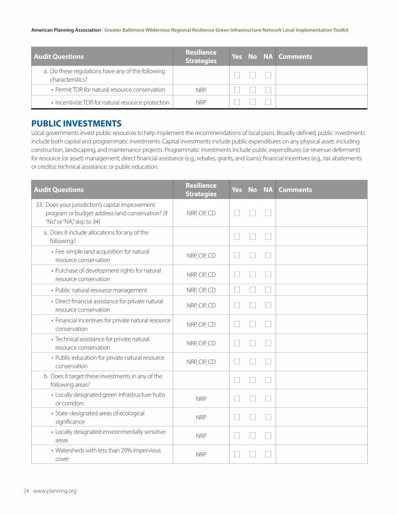
a. Do these regulations have any of the following characteristics?
• Permit TDR for natural resource conservation NRP
• Incentivize TDR for natural resource protection NRP
PUBLIC INVESTMENTSLocal governments invest public resources to help implement the recommendations of local plans. Broadly defined, public investments include both capital and programmatic investments. Capital investments include public expenditures on any physical asset, including construction, landscaping, and maintenance projects. Programmatic investments include public expenditures (or revenue deferment) for resource (or asset) management; direct financial assistance (e.g., rebates, grants, and loans); financial incentives (e.g., tax abatements or credits); technical assistance; or public education.
Audit Questions Resilience Strategies Yes No NA Comments
33. Does your jurisdiction’s capital improvement program or budget address land conservation? (If “No” or “NA,” skip to 34)
NRP, CIP, CD
a. Does it include allocations for any of the following?
• Fee-simple land acquisition for natural resource conservation
NRP, CIP, CD
• Purchase of development rights for natural resource conservation
NRP, CIP, CD
• Public natural resource management NRP, CIP, CD
• Direct financial assistance for private natural resource conservation
NRP, CIP, CD
• Financial incentives for private natural resource conservation
NRP, CIP, CD
• Technical assistance for private natural resource conservation
NRP, CIP, CD
• Public education for private natural resource conservation
NRP, CIP, CD
b. Does it target these investments in any of the following areas?
• Locally designated green infrastructure hubs or corridors
NRP
• State-designated areas of ecological significance
NRP
• Locally designated environmentally sensitive areas
NRP
• Watersheds with less than 20% impervious cover
NRP
Tool 1: Local Planning System Audit | American Planning Association
www.planning.org 25
Audit Questions Resilience Strategies Yes No NA Comments
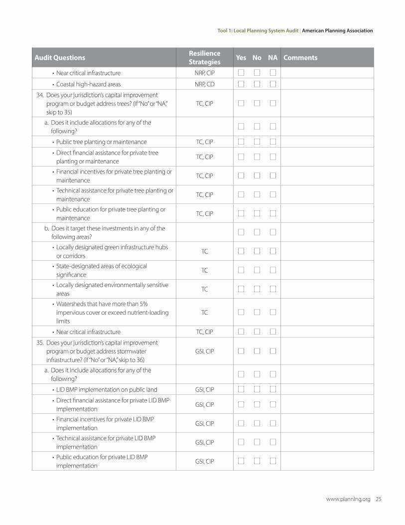
• Near critical infrastructure NRP, CIP
• Coastal high-hazard areas NRP, CD
34. Does your jurisdiction’s capital improvement program or budget address trees? (If “No” or “NA,” skip to 35)
TC, CIP
a. Does it include allocations for any of the following?
• Public tree planting or maintenance TC, CIP
• Direct financial assistance for private tree planting or maintenance
TC, CIP
• Financial incentives for private tree planting or maintenance
TC, CIP
• Technical assistance for private tree planting or maintenance
TC, CIP
• Public education for private tree planting or maintenance
TC, CIP
b. Does it target these investments in any of the following areas?
• Locally designated green infrastructure hubs or corridors
TC
• State-designated areas of ecological significance
TC
• Locally designated environmentally sensitive areas
TC
• Watersheds that have more than 5% impervious cover or exceed nutrient-loading limits
TC
• Near critical infrastructure TC, CIP
35. Does your jurisdiction’s capital improvement program or budget address stormwater infrastructure? (If “No” or “NA,” skip to 36)
GSI, CIP
a. Does it include allocations for any of the following?
• LID BMP implementation on public land GSI, CIP
• Direct financial assistance for private LID BMP implementation
GSI, CIP
• Financial incentives for private LID BMP implementation
GSI, CIP
• Technical assistance for private LID BMP implementation
GSI, CIP
• Public education for private LID BMP implementation
GSI, CIP
American Planning Association | Greater Baltimore Wilderness Regional Resilience Green Infrastructure Network Local Implementation Toolkit
26 www.planning.org
Audit Questions Resilience Strategies Yes No NA Comments
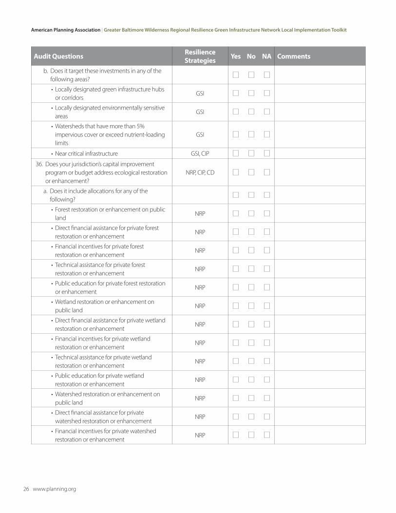
b. Does it target these investments in any of the following areas?
• Locally designated green infrastructure hubs or corridors
GSI
• Locally designated environmentally sensitive areas
GSI
• Watersheds that have more than 5% impervious cover or exceed nutrient-loading limits
GSI
• Near critical infrastructure GSI, CIP
36. Does your jurisdiction’s capital improvement program or budget address ecological restoration or enhancement?
NRP, CIP, CD
a. Does it include allocations for any of the following?
• Forest restoration or enhancement on public land
NRP
• Direct financial assistance for private forest restoration or enhancement
NRP
• Financial incentives for private forest restoration or enhancement
NRP
• Technical assistance for private forest restoration or enhancement
NRP
• Public education for private forest restoration or enhancement
NRP
• Wetland restoration or enhancement on public land
NRP
• Direct financial assistance for private wetland restoration or enhancement
NRP
• Financial incentives for private wetland restoration or enhancement
NRP
• Technical assistance for private wetland restoration or enhancement
NRP
• Public education for private wetland restoration or enhancement
NRP
• Watershed restoration or enhancement on public land
NRP
• Direct financial assistance for private watershed restoration or enhancement
NRP
• Financial incentives for private watershed restoration or enhancement
NRP

Tool 1: Local Planning System Audit | American Planning Association
www.planning.org 27
Audit Questions Resilience Strategies Yes No NA Comments
• Technical assistance for private watershed restoration or enhancement
NRP
• Public education for private watershed restoration or enhancement
NRP
• Coastal habitat restoration or enhancement on public land
NRP, CD
• Direct financial assistance for private coastal habitat restoration or enhancement
NRP, CD
• Financial incentives for private coastal habitat restoration or enhancement
NRP, CD
• Technical assistance for private coastal habitat restoration or enhancement
NRP, CD
• Public education for private coastal habitat restoration or enhancement
NRP, CD
b. Does it target these investments in any of the following areas?
• Locally designated green infrastructure hubs or corridors
NRP
• Locally designated environmentally sensitive areas
NRP
• Watersheds that have more than 5% impervious cover or exceed nutrient-loading limits
NRP
• Near critical infrastructure NRP, CIP
• Coastal high-hazard areas NRP, CD
Disclaimer: The views and conclusions contained in this toolkit are those of American Planning Association, and should not be interpreted as representing the opinions or policies of the U.S. Government, the National Fish and Wildlife Foundation, or its funding sources. Mention of trade names or commercial products does not constitute their endorsement by the U.S. Government, the National Fish and Wildlife Foundation, or its funding sources.