the wreck of the islander
TRANSCRIPT

Seaway Trail, Inc.
315.646.1000
www.seawaytrail.com
NY Sea Grant
315.312.3042
www.nyseagrant.org
This brochure was funded by a Scenic Byway
Grant from the FHWA to Seaway Trail, Inc.
The Wreck of the
Islander1871 Sidewheel Steamship
Alexandria Bay, NY
Dive Site Steward
Dive Flag Laws in New YorkOnce a boat is anchored and diving is about to begin, the vessel must fly a red and
white divers down” flag. By law, the boat must also fly the blue and white “Alpha” flag.
Divers must stay within 100 feet of the dive flags. Surface vessels must stay a minimum
of 100 feet away from the flags. All standard, safe diving procedures relating to towing
dive flags must be followed.
Welcome to the Seaway TrailNew York State’s National Scenic Byway... the road that leads to great adventures
and lifelong memories for you and your family.
The New York State Seaway Trail is a 454 mile scenic route paralleling the St. Lawrence River, Lake
Ontario, the Niagara River and Lake Erie. Seaway Trail Pennsylvania continues the route 50 miles along
Lake Erie to the Ohio state line. A well-marked alternative to interstate highways and toll roads, the
Seaway Trail leads to eye-opening treasures you might otherwise overlook. Traveling the Trail takes you
to sophisticated cities, quaint villages, fishing ports, and dozens of family attractions, restaurants, accom-
modations and shops. Come visit us soon. We’ll help make your next vacation one you’ll remember for
a lifetime.
Use the green and white trailblazers along the Seaway Trail to guide you on your
journey from West Springfield on Lake Erie to Rooseveltown on the St. Lawrence.
Each marker features footprints and a watermark reminding you that the route parallels
NYS’s and Pennsylvania’s freshwater coastline.
NYS Seaway Trail is proud to have been selected as a National Scenic Byway by the
U.S. Department of Transportation. National Scenic Byways “possess outstanding
qualities that exemplify the regional characteristics of our nation.” The Seaway Trail was
chosen for its unique landscape which has been sculpted by the forces of nature and for
its historical significance.
“Dive the Seaway Trail” and enjoy some of the Northeast’s finest freshwater diving
sites, with a full complement of Wreck, Shoal, Deep, and Historical diving. For over
two centuries the lake and rivers have been major shipping thoroughfares. Today, the
Seaway Trail is the final resting place of hundreds of ships, dating back to the late
1700’s.
Experience all the terrific dives of the
Seaway Trail!
Stewards are organizations that volunteer to be
the local representative for the dive site. They
publicize, monitor, and buoy it; advocate for its
responsible use, and interpret it for non-divers
to promote public awareness of our Great
Lakes underwater maritime heritage and cultural
resources. The Islander currently does not
have a steward. If you are interested, contact
New York Sea Grant at the number below.
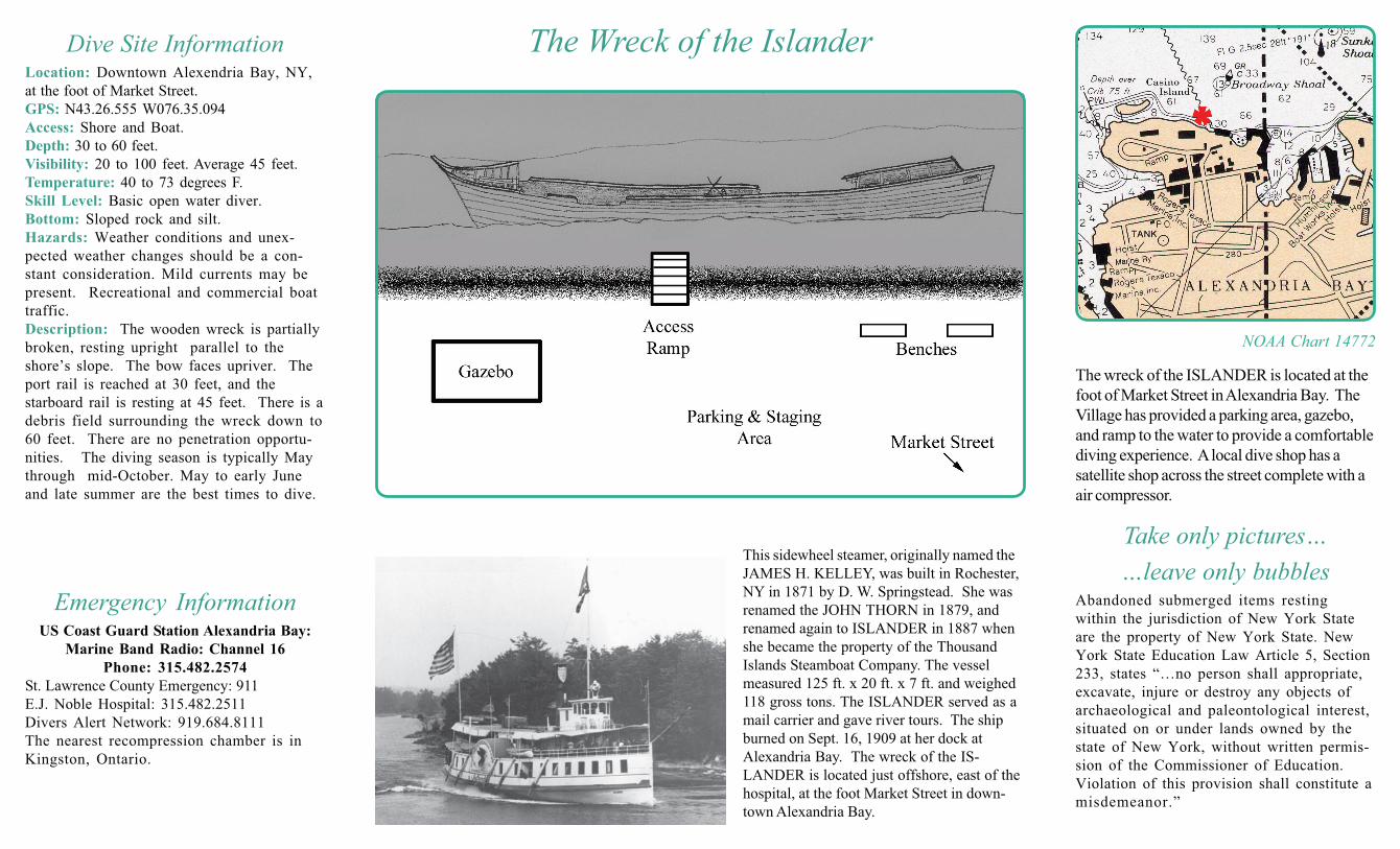
Dive Site InformationLocation: Downtown Alexendria Bay, NY,
at the foot of Market Street.
GPS: N43.26.555 W076.35.094
Access: Shore and Boat.
Depth: 30 to 60 feet.
Visibility: 20 to 100 feet. Average 45 feet.
Temperature: 40 to 73 degrees F.
Skill Level: Basic open water diver.
Bottom: Sloped rock and silt.
Hazards: Weather conditions and unex-
pected weather changes should be a con-
stant consideration. Mild currents may be
present. Recreational and commercial boat
traffic.
Description: The wooden wreck is partially
broken, resting upright parallel to the
shore’s slope. The bow faces upriver. The
port rail is reached at 30 feet, and the
starboard rail is resting at 45 feet. There is a
debris field surrounding the wreck down to
60 feet. There are no penetration opportu-
nities. The diving season is typically May
through mid-October. May to early June
and late summer are the best times to dive.
Take only pictures…
…leave only bubblesAbandoned submerged items resting
within the jurisdiction of New York State
are the property of New York State. New
York State Education Law Article 5, Section
233, states “…no person shall appropriate,
excavate, injure or destroy any objects of
archaeological and paleontological interest,
situated on or under lands owned by the
state of New York, without written permis-
sion of the Commissioner of Education.
Violation of this provision shall constitute a
misdemeanor.”
The Wreck of the Islander
This sidewheel steamer, originally named the
JAMES H. KELLEY, was built in Rochester,
NY in 1871 by D. W. Springstead. She was
renamed the JOHN THORN in 1879, and
renamed again to ISLANDER in 1887 when
she became the property of the Thousand
Islands Steamboat Company. The vessel
measured 125 ft. x 20 ft. x 7 ft. and weighed
118 gross tons. The ISLANDER served as a
mail carrier and gave river tours. The ship
burned on Sept. 16, 1909 at her dock at
Alexandria Bay. The wreck of the IS-
LANDER is located just offshore, east of the
hospital, at the foot Market Street in down-
town Alexandria Bay.
Emergency InformationUS Coast Guard Station Alexandria Bay:
Marine Band Radio: Channel 16
Phone: 315.482.2574
St. Lawrence County Emergency: 911
E.J. Noble Hospital: 315.482.2511
Divers Alert Network: 919.684.8111
The nearest recompression chamber is in
Kingston, Ontario.
NOAA Chart 14772
The wreck of the ISLANDER is located at the
foot of Market Street in Alexandria Bay. The
Village has provided a parking area, gazebo,
and ramp to the water to provide a comfortable
diving experience. A local dive shop has a
satellite shop across the street complete with a
air compressor.