the project civic center transit district plan · civic center transit district plan 16th street...
TRANSCRIPT

June 25, 2015
Civic Center Transit District Plan
16th Street Mall
For more information visit us at www.rtd-denver.com/civiccenter
The Project
THE PROJECT |To establish the vision for a new transit district that includes transit operations, multi-modal mobility and connectivity, public realm planning and economic development opportunities.
THE SCHEDULE |The project began in early 2015 and is expected to wrap-up by the end of the year.
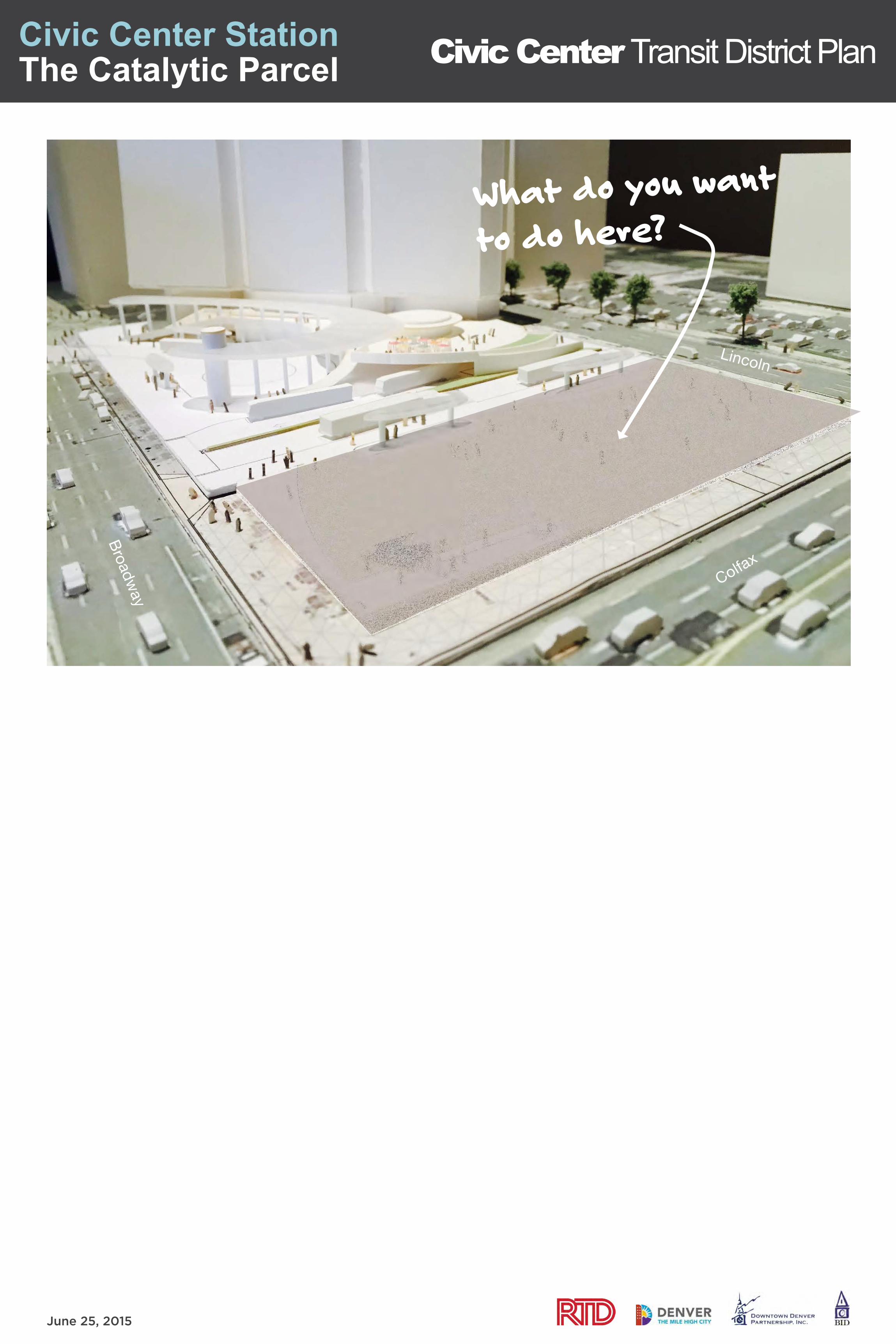
THE “CATALYTIC PARCEL” |The effort will also analyze activation strategies for a new 20,000 square-foot parcel created by the upcoming rehabilitation of Civic Center Station.
0´ 200´ 400´
CCTD BoundaryInfluence Area
Light Rail LinesLight Rail Station
CCS: Civic Center Station CCS Catalytic Parcel
STUDY AREA DIAGRAM

June 25, 2015
Civic Center Transit District Plan
Mobility Reimagine Civic Center Station as the complement to DUS and the major mobility hub for the southeast sector of Downtown Denver
ConnectivityEndorse planned, complete networks for transit, pedestrians and bicyclists to connect the district internally and externally to its neighbors
Economic Development Optimize economic development potential by creating strategies to redevleop underutilized district properties
Create a CCTD Public Realm Plan with a distinct sense of place that acts as a portal between16th Street Mall, Civic Center, the State Capitol, and Capitol Hill Neighborhood, creates a unique district identity, and fosters more inviting pedestrian and bicycle connections to its surroundings
Goa
lsG
oals
Goa
ls
Goa
ls
Project Goals
Placemaking

June 25, 2015
Civic Center Transit District Plan
PROJECT HIGHLIGHTS
• Nine bus bays
• Glass-enclosed terminal building
• Rebuild bus concourse
• Bus ramp extension connecting Broadway to Lincoln
• Open view from 16th Street Mall to the State Capitol
TENTATIVE TIMELINE
• November 2014 Final design completed
• Spring 2015 Request for Proposal sent out for project
• Summer 2015 RTD Board of Directors votes on proposals received
• Winter 2015 Construction begins if a proposal is approved and within budget
Once construction begins, the project is expected to take approximately 12 months to complete.
DESIGN RENDERINGS
CONCEPTUAL MODEL
Civic Center Station Rehabilitation Project

June 25, 2015
Civic Center Transit District Plan
Clevela
nd Place
Tremont P
lace
E 17th Street
E Colfax Avenue
E 14th Street
E 16th Street
Linc
oln
Stre
et
Broa
dway
Stre
et
W 14th Stre
et
Cheyenne P
lace
N
STATE CAPITOL
E 18th Street
E 19th Street
Glenarn
Place
E 20th Street
MISSING BIKE LANE
OBSTACLES IN SIDEWALK
UNFAVORABLE SIGNAL POLE PLACEMENT
CCS
LONG PEDESTRIAN CROSSING ON LEFT-TURN SIGNAL
Connectivity Issues
LONG DIAGONAL PEDESTRIAN CROSSINGS
Welton Plac
e

June 25, 2015
Civic Center Transit District Plan
IMPROVEMENT HIGHLIGHTS
• 2017 Station remodel
• Street-level improvements already planned for implementation:
+ 16th Avenue bike lane + 16th/Broadway improved crosswalks
• Other potential improvements:
+ Pedestrian/bike enhancements including pedestrian refuges on Colfax + Operations and signal time adjustments within existing streets to improve pedestrian safety
DESIGN RENDERINGS
2015 ~ 20180-3 YEARS
Immediate Improvements

June 25, 2015
Civic Center Transit District Plan
IMPROVEMENT HIGHLIGHTS
• Build naturally off existing service – right side transit
• Evaluate signalization phasing for transit, pedestrians and bicyclists to improve safety and traffic flow
• Can be implemented within District boundaries (17th Ave to 13th Ave) without whole-corridor planning as funding is identified
• Cycle track and bus lane on Lincoln could switch sides as an alternative operation
• Some improvements could be phased earlier by implementing re-striping within existing roadway
2018 ~ 20223 - 7 YEARS
13th
14th
Colfax
16th
17th
18th
19th
20th
12th
Broa
dway
Linc
oln
RIGHT SIDE TRANSIT
BROADWAY EVALUATE SIGNAL PHASING
Short-Term Improvement Concepts
NACTO URBAN STREET DESIGN GUIDE
INITIAL IMPLEMENTATION AREA
N
*
Representative images for illustration purposes only

June 25, 2015
Civic Center Transit District Plan
TRANSIT
LEFT
TURN
BIKE
TRANSIT
BUS LAYOVER/O
FF-P
EAK
PARKIN
G (BEYOND)
BIKE
PARKIN
G
BROADWAY 100’ ROW BROADWAY 100’ ROW LINCOLN 90’ ROW *
Bikes could shift to east side, buses could be combined on west side *
Short-Term Options Broadway & Lincoln Improvements
LINCOLN 90’ ROW
TRANSIT
BUS LAYOVER/O
FF-P
EAK
PARKIN
G (BEYOND)
0' 5' 10' 20' 40'
0' 5' 10' 20' 40'
BROADWAY 100’ ROW
TRANSIT
BIKELEFT
TURN/PA
RKING
(BEYOND)
CYCLETR
ACK
RIGHT SIDE TRANSIT2-WAY CYCLE TRACK ON BROADWAY OPTION
RIGHT SIDE TRANSIT1-WAY CYCLE TRACK ON BROADWAY & LINCOLN OPTION
BENEFITS• Simplicity for bike network• Natural right-side transit operations• Maintains wider sidewalks• Station development site access from
Lincoln
TRADEOFFS• Impacts to existing traffic operations• Need for separate bicycle signal phase
(though benefit to pedestrians also)• Potential impacts to turning
movements due to signal and lane modifications
FEATURES• Right side transit lane and enhanced bus stops• One-way, left side, protected bike lanes on Broadway & Lincoln• Broadway/Lincoln Corridor Study will determine final bike facility design• Some parking/loading
BENEFITS• Potentially more parking/loading on
Broadway• Natural right-side transit operations• Doesn’t mandate a separate signal
phase at Colfax (but would be a benefit to pedestrians)
TRADEOFFS• Impacts to existing traffic operations• Requires 1 block of connecting bike
facilities on cross streets• Considerably narrower west sidewalk
on Lincoln• Access to station development site
crosses both cycle tracks
0´ 10´ 15´
Highlighted FacilityTransit Lane
Transit Loading ZoneCycletrack/Bike Lane
Travel LaneParking Beyond
REPRESENTATIVE SECTIONS LOOKING NORTH
Bus Layover/Off-Peak Parking Beyond
Sections0´ 15´ 30´
Plans
REPRESENTATIVE SECTIONS LOOKING NORTH
PLAN
LIN
CO
LN
BR
OA
DW
AY
COLFAX
PLAN
LIN
CO
LN
BR
OA
DW
AY
COLFAX
Broadway & Lincoln Improvements
2-WAY CYCLE TRACK ON BROADWAY OPTION 2-Way with Wider Sidewalk or1-Way with Narrower Sidewalks?
FEATURES• Right side transit lane and enhanced bus stops• Two-way, left side protected cycletrack on Broadway• Broadway/Lincoln Corridor Study will determine final bike facility design• Some parking/loading
Representative images for illustration purposes only

June 25, 2015
Civic Center Transit District Plan
0' 5' 10' 20' 40'
BR
OA
DW
AY
LIN
CO
LN
COLFAX
PLAN
BR
OA
DW
AY
WIDE LANDSCAPED MEDIAN OPTIONFEATURES• Widen islands and pedestrian refuges • Grand boulevard/placemaking opportunity• Divert left turns to other intersections in system• Can be implemented independent of Broadway/Lincoln improvements• Requires further evaluation
0' 5' 10' 20' 40'
PLAN
LIN
CO
LN
COLFAX
BR
OA
DW
AY
NARROW UN-LANDSCAPED MEDIAN OPTIONFEATURES• Add protective pedestrian refuges to existing islands• Maintain left-turn movements from Colfax onto Broadway & Lincoln• Can be implemented independent of Broadway/Lincoln improvements• Requires further evaluation
0´ 15´ 30´
Highlighted FacilityTransit Lane
Transit Loading ZoneCycletrack/Bike Lane
Travel LaneParking Beyond
Bus Layover/Off-Peak Parking BeyondLandscaped Median
Plans
Short-Term Options Colfax Improvements
Enhanced Pedestrian Refuge/Left Turns Maintained? orWider Pedestrian Refuge/Left Turns Eliminated?
Representative images for illustration purposes only

June 25, 2015
Civic Center Transit District Plan
LONG TERM HIGHLIGHTS
• Assumes transit growth far exceeds current projections
• Requires decisions on city-wide mobility hubs and corridors
• Likely would result in new grade-separated station
• Possible integration with long-term development on catalytic site or combined with other major improvements in immediate area
2035 ~ 204520+ YEARS
2022 ~ 20357-20 YEARS
Medium & Long Term Visioning
MEDIUM TERM HIGHLIGHTS
• Part of a larger effort to address transit access into Downtown
• Likely to require full corridor study (e.g. 20th Street to I-25)
• Transformative re-design of public realm at street level
• Will be consistent with other plans/studies
NACTO URBAN STREET DESIGN GUIDE
Representative images for illustration purposes only

June 25, 2015
Civic Center Transit District Plan
CHERRY CREEK TRAIL
CHERRY CREEK TRAIL
DENV
ER U
NION
STAT
ION
COLORADOCONVENTION
CENTER
RTDCIVIC CENTER
STATION
SOUT
H PL
ATTE
RIV
ER
DENVER PERFORMING
ARTS COMPLEX
COORSFIELD
PEPSICENTER
STATECAPITOL
SO
UT
H P
LA
TT
ER
IVE
R G
RE
EN
WA
Y
7TH ST
LYLE C
T
19TH ST
18TH ST
9TH ST
BRYANT ST
W B
YRON PL
INCA ST
ER
IE S
T
12TH ST
W 2
9TH AVE
W 9
TH AVE
E SPEER BLVD
13TH ST
CH
ES
TN
UT
PL
CR
ES
CE
NT
DR
12TH ST
14TH ST
FOX ST
18TH ST
BA
SS
ET
T S
T
LA
RIM
ER
ST
HURON ST
WE
WA
TTA
ST
W 2
8TH AVE
W 10
TH AVE
17TH ST
19TH ST
W C
AITHNES
S PL
RO
CK
MO
NT
DR
WE
WA
TTA
ST
W 3
1ST A
VE
DECATUR ST
CH
OP
PE
R C
IRCLE
W A
RGYLE PL
FOX ST
EL
ITCH CIR
LITTLE RAVEN ST
LIPAN S
T
W DUNKELD PL
CU
RT
IS S
T
CO
UR
T P
L
CL
EV
EL
AN
D P
L
HUMBOLDT ST
W 2
6TH AVE
W 2
7TH AVE
UMATIL
LA ST
VALLEJO S
T
BO
UL
DE
R S
T
MARIP
OSA ST
ELATI ST
E 12TH A
VE
W 11
TH A
VE
DELAWARE ST
DECATUR ST
ALC
OTT
ST
PL
AT
TE
ST
MARION ST
5TH ST
TR
EM
ON
T P
L
BRYANT S
T
NAVAJO S
T
WYA
NDOT ST
ALCOTT S
TBRYA
NT ST
QUIVAS S
T
VALLEJO S
T
SHOSHONE ST
DELAWARE ST
ACOMA ST
WA
LN
UT
ST
EMERSON ST
CLAY ST
OSAGE ST
ELATI ST
GL
EN
AR
M P
L
7TH ST
GL
EN
AR
M P
L
CHEROKEE ST
WA
ZE
E S
T
TEJON ST
E 18TH A
VE
WE
LTO
N S
T
MA
RK
ET
ST
BANNOCK ST
CLAY ST
21ST ST
24TH ST
GALAPAGO ST
W 3
3RD AVE
W 3
2ND AVE
W 14
TH AVE
E 14TH A
VE
E 13TH A
VE17TH ST
W 11
TH AVE
ZUNI ST
MARIPOSA ST
KALAMATH STLIPAN ST
SANTA FE DR
GALAPAGO ST
WE
LTO
N S
T
W 3
4TH AVE
16TH ST MALLW 3
5TH AVE
W 3
5TH AVE
PEARL ST
PENNSYLVANIA ST
W 3
6TH AVE
W 3
6TH AVE
W 3
7TH AVE
W 3
7TH AVE
CLARKSON ST
WASHINGTON ST
LOGAN ST
GRANT ST
CA
LIF
OR
NIA
ST
E 16TH A
VE
W C
OLFAX A
VE
CU
RT
IS S
TC
UR
TIS
ST
W 13
TH AVE
BL
AK
E S
T
E 17TH A
VE
E 17TH A
VE
AR
AP
AH
OE
ST
TR
EM
ON
T P
L
ELIOT S
T.
SHERMAN ST
18TH ST
DE
LG
AN
Y S
T
CA
LIF
OR
NIA
ST
AU
RA
RIA
PA
RK
WA
Y
LA
RIM
ER
ST
LA
WR
EN
CE
ST
W C
OLFAX A
VE
WA
TE
R S
T
OGDEN ST
WY
NK
OO
P S
T
PECOS ST
N SPEER BLVD
W 2
3RD AVE
CE
NT
RA
L S
T
OSAGE ST
E 20TH A
VE
W 2
9TH AVE
14TH ST
22ND ST
15TH ST
19TH ST
W 8
TH AVE
15TH ST
20TH ST
LINCOLN ST
PARK AVE
DOWNING ST
CH
AM
PA
ST
ST
OU
T S
T
BROADWAY
SPEER BLVD
BROADWAY
E 19TH A
VE
25
CENTRALPLATTE VALLEY
(CPV)AURARIA
AURARIA
COMMERCIALCORE
CULTURALCORE
GOLDENTRIANGLE
LODO
ARAPAHOESQUARE
BALLPARK
CPV PROSPECT
CPV COMMONS
CITY & COUNTYBUILDING
76
74
77
75 71
72
54
39
65
67
44
4653
48
60
43
45
64
57
62
63
55
59
66
49
58
19
24
69
12
3
25
2930 68
28
27
16 18 20
22
26
35
40
56
47
50
52
33
34
7078
73
42
3738
23
14
9
11
15
17 5
7
6
3210
4
31
8
12
21
4151
36
61
13
STATESTATESTATESTATECAPITOLCAPITOLCAPITOL
HUMBOLDT ST
HUMBOLDT ST
MARION ST
EMERSON ST
EMERSON ST
EMERSON ST
E 14TH A
VE
E 13TH A
VE
PEARL ST
PENNSYLVANIA ST
PENNSYLVANIA ST
PENNSYLVANIA ST
PENNSYLVANIA ST
CLARKSON ST
WASHINGTON ST
LOOGGAANNSSTT
E 16TH A
VE
W C
OLFAX A
VE
E 17TH A
VE
E17
THAVAVA
E
OGDEN ST
OGDEN ST
LINCOLN ST
DOWNING ST
DOWNING ST
Economic Development Opportunity
0´ 264´ 528´
CCTD BoundaryInfluence Area
Business GaragesBusiness Surface Lots
VACANT PARCELS, PAVED SURFACE LOTS, & PARKING GARAGES
Public GaragesPublic Surface Lots
CCS: Civic Center Station Vacant Parcels 0.1 miles
CIVIC CENTER DISTRICT HAS A HIGH PERCENTAGE OF SURFACE PARKING LOTS
ZONING MAP DOWNTOWN DENVER DEVELOPMENTS 2008-2014

June 25, 2015
Civic Center Transit District Plan
District Wayfinding
District Identity
How will the District be defined? 1/4 Mile Radius
1/2 Mile Radius
CCS
KEY
CCTD Boundary
Influence Area
Light Rail Lines
Light Rail Station
16th Street Mall
CCS Catalytic Parcel
CIVIC CENTER TRANSIT DISTRICT PLANStudy Area Diagram
DRAFT February 6, 2015
1” = 200’N
CIVIC CENTER PARK
1/4 Mile Radius
1/2 Mile Radius
CCS
KEY
CCTD Boundary
Influence Area
Light Rail Lines
Light Rail Station
16th Street Mall
CCS Catalytic Parcel
CIVIC CENTER TRANSIT DISTRICT PLANStudy Area Diagram
DRAFT February 6, 2015
1” = 200’N
CIVIC CENTER PARK
What do you use today to find your way around?
1/4 Mile Radius
1/2 Mile Radius
CCS
KEY
CCTD Boundary
Influence Area
Light Rail Lines
Light Rail Station
16th Street Mall
CCS Catalytic Parcel
CIVIC CENTER TRANSIT DISTRICT PLANStudy Area Diagram
DRAFT February 6, 2015
1” = 200’N
16TH STREET MALL
1/4 Mile Radius
1/2 Mile Radius
CCS
KEY
CCTD Boundary
Influence Area
Light Rail Lines
Light Rail Station
16th Street Mall
CCS Catalytic Parcel
CIVIC CENTER TRANSIT DISTRICT PLANStudy Area Diagram
DRAFT February 6, 2015
1” = 200’N
16TH STREET MALL
1/4 Mile Radius
1/2 Mile Radius
CCS
KEY
CCTD Boundary
Influence Area
Light Rail Lines
Light Rail Station
16th Street Mall
CCS Catalytic Parcel
CIVIC CENTER TRANSIT DISTRICT PLANStudy Area Diagram
DRAFT February 6, 2015
1” = 200’N
CIVIC CENTER PARK
1/4 Mile Radius
1/2 Mile Radius
CCS
KEY
CCTD Boundary
Influence Area
Light Rail Lines
Light Rail Station
16th Street Mall
CCS Catalytic Parcel
CIVIC CENTER TRANSIT DISTRICT PLANStudy Area Diagram
DRAFT February 6, 2015
1” = 200’N
CIVIC CENTER PARK
THE BRANDING CHALLENGE AT THE CIVIC CENTER TRANSIT STATION IS TO CREATE AN IDENTITY AND WAYFINDING PORTAL TO THE SURROUNDING ECLECTIC NEIGHBORHOODS AND BRING AWARENESS TO THE UNIQUE ART AND CULTURAL EXPERIENCES AS WELL AS SHOPPING, DINING, AND ENTERTAINMENT DESTINATIONS.
1/4 Mile Radius
1/2 Mile Radius
CCS
KEY
CCTD Boundary
Influence Area
Light Rail Lines
Light Rail Station
16th Street Mall
CCS Catalytic Parcel
CIVIC CENTER TRANSIT DISTRICT PLANStudy Area Diagram
DRAFT February 6, 2015
1” = 200’N
DOWNTOWN
BROWN PALACE HOTEL PIANO ON 16TH STREET MALL
1/4 Mile Radius
1/2 Mile Radius
CCS
KEY
CCTD Boundary
Influence Area
Light Rail Lines
Light Rail Station
16th Street Mall
CCS Catalytic Parcel
CIVIC CENTER TRANSIT DISTRICT PLANStudy Area Diagram
DRAFT February 6, 2015
1” = 200’N
14TH STREET
1/4 Mile Radius
1/2 Mile Radius
CCS
KEY
CCTD Boundary
Influence Area
Light Rail Lines
Light Rail Station
16th Street Mall
CCS Catalytic Parcel
CIVIC CENTER TRANSIT DISTRICT PLANStudy Area Diagram
DRAFT February 6, 2015
1” = 200’N
CAPITAL HILL
CAPITAL HILL / PEOPLE’S FAIR IN CIVIC CENTER BANNER PROGRAM: 13TH STREET
1/4 Mile Radius
1/2 Mile Radius
CCS
KEY
CCTD Boundary
Influence Area
Light Rail Lines
Light Rail Station
16th Street Mall
CCS Catalytic Parcel
CIVIC CENTER TRANSIT DISTRICT PLANStudy Area Diagram
DRAFT February 6, 2015
1” = 200’N
GOLDEN TRIANGLE
DENVER ART MUSEUM
1/4 Mile Radius
1/2 Mile Radius
CCS
KEY
CCTD Boundary
Influence Area
Light Rail Lines
Light Rail Station
16th Street Mall
CCS Catalytic Parcel
CIVIC CENTER TRANSIT DISTRICT PLANStudy Area Diagram
DRAFT February 6, 2015
1” = 200’N
CAPITAL HILL
UPPER COLFAX
1/4 Mile Radius
1/2 Mile Radius
CCS
KEY
CCTD Boundary
Influence Area
Light Rail Lines
Light Rail Station
16th Street Mall
CCS Catalytic Parcel
CIVIC CENTER TRANSIT DISTRICT PLANStudy Area Diagram
DRAFT February 6, 2015
1” = 200’N
CAPITAL HILL
UPPER COLFAX
1/4 Mile Radius
1/2 Mile Radius
CCS
KEY
CCTD Boundary
Influence Area
Light Rail Lines
Light Rail Station
16th Street Mall
CCS Catalytic Parcel
CIVIC CENTER TRANSIT DISTRICT PLANStudy Area Diagram
DRAFT February 6, 2015
1” = 200’N
CAPITAL HILL
UPPER COLFAX
1/4 Mile Radius
1/2 Mile Radius
CCS
KEY
CCTD Boundary
Influence Area
Light Rail Lines
Light Rail Station
16th Street Mall
CCS Catalytic Parcel
CIVIC CENTER TRANSIT DISTRICT PLANStudy Area Diagram
DRAFT February 6, 2015
1” = 200’N
14TH STREET

June 25, 2015
Civic Center Transit District Plan Placemaking at Civic Center Station
Inspirations

June 25, 2015
Civic Center Transit District Plan
CIVIC CENTER PARKSTATE CAPITOL
CIVIC CENTER STATION
16TH STREET MALL
DENVER ART MUSEUM
CLYFFORD STILL MUSEUM
DENVER PUBLIC LIBRARY
DENVER PAVILIONS
W COLFAX AVE E COLFAX AVE
BR
OA
DW
AY
ST
RE
ET
Map Your Favorite Destinations
Missing something? tell us here6
U.S. MINT
HISTORY COLORADO
COLORADO CONVENTION CENTER
LIN
CO
LN S
TR
EE
T
DENVER CITY & COUNTY BUILDING
June 25, 2015
Civic Center Transit District Plan
What do you want to do here?
Civic Center Station The Catalytic Parcel
Broadw
ay
Lincoln
Colfax

Civic Center Transit District Plan
June 25 2015
Help, I am Lost!
CIVIC CENTER PARKSTATE CAPITOL
CIVIC CENTER STATION
16TH STREET MALL
DENVER ART MUSEUM
DENVER PUBLIC LIBRARY
DENVER PAVILIONS
W COLFAX AVE E COLFAX AVE
BR
OA
DW
AY
ST
RE
ET
U.S. MINT
HISTORY COLORADO
COLORADO CONVENTION CENTER
LIN
CO
LN S
TR
EE
T
DENVER CITY & COUNTY BUILDING
I-87
What challenges do you face when you navigating this area?

Civic Center Transit District Plan It’s 2025, What do you love about Downtown Denver?

June 25 2015