the production of landslides risks and local responses · however floods that cause major...
TRANSCRIPT
The Production of Landslides Risks and Local Responses:
A Case Study of Bhirkot, Dolakha District of Nepal
Dil B. Khatri Bikash Adhikari Niru Gurung Adam Pain
CCRI case study 1
The Production of Landslides Risks and Local Responses:
A Case Study of Bhirkot, Dolakha District of Nepal
Dil B. Khatri, ForestAction Nepal
Bikash Adhikari, ForestAction Nepal
Niru Gurung, ForestAction Nepal
Adam Pain, Danish Institute for International Studies
Climate Change and Rural Institutions Research Project
In collaboration with:
Copyright © 2015
ForestAction Nepal
Southasia Institute of Advanced Studies
Published by
ForestAction Nepal
PO Box 12207, Kathmandu, Nepal
Southasia Institute of Advanced Studies
Baneshwor, Kathmandu, Nepal
Photos:
Design and Layout: Sanjeeb Bir Bajracharya
Suggested Citation:
Khatri, D.B., Adhikari, B., Gurung, N. and Pain, A. 2015. The Production of Landslides
Risks and Local Responses: A Case Study of Bhirkot, Dolakha District of Nepal. Case Study
Report 1. Kathmandu: ForestAction Nepal and Southasia Institute of Advance Studies.
The views expressed in this discussion paper are entirely those of the authors and do not
necessarily reflect the views of ForestAction Nepal and SIAS.
Table of Contents
1. Introduction ....................................................................................................................... 1
2. Locating Bhirkot in Dolakha ............................................................................................. 4
3. The origins of the Bhirkot landslide .................................................................................. 6
4. The August 2012 flashflood and landslide ...................................................................... 10
4.1. Description of event (effects and immediate response from household)................. 10
4.2. Response to disaster: ............................................................................................... 11
4.3. Early recovery ......................................................................................................... 12
4.4. Later Responses ....................................................................................................... 13
5. Consequences of the flashflood ....................................................................................... 14
5.1. Recovery from disaster increased burden to the affected household ...................... 14
5.2. Support of community institutions and neighbours was significant ........................ 15
5.3. How and why did school get more external support and not by the affected
households? ............................................................................................................. 16
5.4. Government response to disaster and changes ........................................................ 17
5.5. Heavy rainfall in 2013 and its affects: ..................................................................... 18
6. Discussion and conclusion .............................................................................................. 18
Acknowledgement
This study was part of a four-country research programme on Climate Change and
Rural Institutions (CCRI) funded by the Danish Foreign Ministry and led by Danish
Institute of International Studies (DIIS), with ForestAction and Southasia Institute of
Advanced Studies (SIAS) as research partners in Nepal. We acknowledge for
financial support from the project. We would also like to thank local people,
community groups, political party leaders and VDC officials of Bhirkot for
cooperation during the field study. This research also benefitted greatly from the
views of District stakeholders at Charikot in the district of Dolakha. We are also
indebted to Gyatri Acharya and Raghu Subedi for their support on coordinating field
activities. We thank Hemant Ojha and Hari Dhungana for their inputs on research
framework . Finally, we are grateful to teams at ForestAction and SIAS for their
support and cooperation in conducting this study.
List of abbreviations
APM All party mechanism
CDO Chief District Officer
CF Community Forestry
CFUG Community Forest User Group
DDC District Development Committee
DDRC District Disaster Relief Committee
DDPRP District Disaster Prepardness and Response Plan
DISCO District Soil Convervation Office
DRSP District Road Support Project
ECARDS Environment, Culture, Agriculture, Research and
Development Society Nepal
GLOF Glacier Lake Outburst Flood
GoN Government of Nepal
Km Kilometer
LAPA Local Adaptation Plan of Action
NAPA National Adaptation Plan of Action
RRN Rural Reconstruction Nepal
1
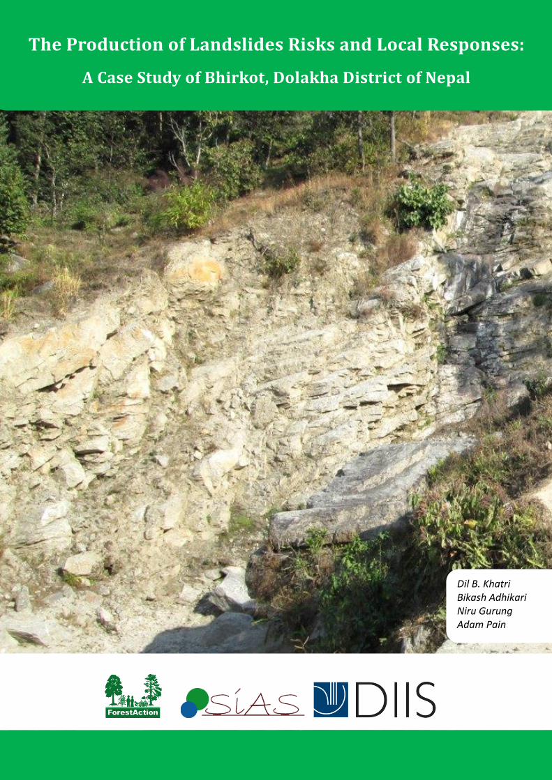
1. Introduction
On the 6th
of August, 2012 , in wards 2,3 and 8 in Bhirkot village development
committee (VDC)1 in the district of Dolakha in the mid hills of Nepal, a heavy
rainstorm started at around 5pm. It continued to rain until late into the evening. The
rainfall triggered a flash flood down a gully that overspilled causing the collapse of
two houses injuring four people. In addition sections of the hill slid down the slope
damaging a number of houses. The movement of mud and water partially destroyed
three schools and a health post. One buffalo and six goats were reported2 to have
been killed and more than 5 ha. of crops were also destroyed by the land movement.
At the base of the slope a landslide blocked the Pushpalal Highway connecting
Dolakha to Ramechap district downstream on the Tamakosi river. The landslide
covered perhaps at most an area in total of one square kilometre including more
localised landslips as well as the larger landslip downslope.
A landslide that caused no deaths and covered a relatively small area might be seen as
scarcely significant and hardly worthy of attention in relation to disaster risk
management. Indeed the case made in the National Adaptation Plan of Action
(NAPA)3 to climate risk (GoN, 2010)
4 that positioned Dolakha as one of Nepal’s most
vulnerable districts to climate induced disaster, focussed more on the relative threat of
a glacier lake outburst flood (GLOF) from Tso Rolpa5 rather than the disaster risk
posed by landslides. But the available and somewhat incomplete evidence on
landslides at a national level suggests that landslides constitute a significant
proportion of the disaster events recorded each year. In the period between February
and December 2012, for example one source6 reported that of the 46 disaster events
recorded within Nepal, 11 (23.9%) were due to landslides while another 14 (30%)
were due to floods. Seven of the landslide events led to a total of 35 deaths which
comprised over 53% of all deaths due to disaster in this period. In contrast floods
caused no deaths but led to 630 people being displaced.
1 VDCs are the administrative subdivisions of districts in Nepal. VDCs in turn are subdivided into wards. 2 This study draws from a range of source and interviews which are described in Annex 1 3 GoN.2010. National Adaptation Plan of Action (NAPA) to Climate Change. Government of Nepal, Ministry of
Environment, Singhdurbar 4 GON. 2010. Government of Nepal: Climate Vulnerability Mapping for Nepal. Ministry of Environment. 5 A glacier lake in the north of Dolakha 6 http://www.disaster-report.com/2012/03/recent-natural-disasters-in-nepal.html, accessed November 13th 2013.
2
Floods do indeed effect more people than landslides at the national level. Six floods
were in the top ten causes of national level disasters in the period 1980 – 2010
accounting for over 70% of the total of 3.9 million people affected by these disasters7.
With respect to the total of 6445 casualities from the top ten disasters during these 20
years, only four floods are in the top ten accounting for 42% of the total casualties.
However floods that cause major displacement and high casualty rates are more a
feature of the terai (plains) than the hills. The Koshi river flood for example in 2012
that affected over 100,000 people was located on the border between Nepal and
India8.
In contrast it is the landslides that are the most frequent disaster in the hills but the
scale of their effects are much smaller. Of the 20 casualty inducing events reported in
Dolakha between 1985 and 20109, 13 were due to landslides. A total of 102 people
were reported killed by these 13 landslides events (77% of all casualties) but over
40% of these deaths came from just four of the landslides. But as a recent study
(ECARDS, 2012) of the five northern VDCs of Dolakha within the Khare-Suri
watershed found that there are many more landslides that cause damage but no deaths.
Of the 14 landslides reported in Chankhu VDC between 1997-2001, only one gave
rise to casualties. Similalry in Marbu VDC none of the seven landslides between 1985
and 2011 caused any deaths. Thus the Bhirkot landslide can be seen, not just as a
small scale landslide but more as a characteristic feature of the risk environment that
many households in Dolakha experience.
Many of the Dolakha district level informants10
were of the view that landslides were
of much greater significance as disasters than the risk of the Tsho Rolpa glacier lake
bursting. The risk of a GLOF was seen as more of what might be termed an
‘existential threat’ - if it happened it might be of catastrophic significance but a threat
to be lived with given the more immediate lived experience of the risk of landslides.
This is not to deny the perhaps rising risk of a GLOF but given the direct experience
of landslides these were given greater weight at the district level over future
hypothetical but potentially catastrophic disasters.
7 http://www.preventionweb.net/english/countries/statistics/?cid=121 , accessed November 13th 2013. 8 http://ncm.org/news/press/koshi_flood_disaster_in_nepal/ Accessed November 13th 2013. 9 DDRC Dolakha (2012) District Disaster Preparedness and Response Plan. Charikot: District Disaster Relief Committee
Dolakha. 10 A senior official of ECARDS─ which was collaborating with UNDP and it’s disaster preparedness program with a focus on
establishing an early warning system for the risk of Tsho-Rolpa GLOF, commented that “rather than GLOF, landslides are main cause of disaster in Dolakha, because it is affecting day to day life of the people. Further, it is smaller landslides which occurred frequently that affect the livelihood of the people more, rather than big landslides”.
3
This disjuncture of views and perceptions of risk between the district and the NAPA
has arisen from two rather different knowledge frameworks. On the one hand the
threat of GLOF comes from a scientific or technocratic knowledge framework that
sees vulnerability as an outcome of a climate induced ‘natural’ disaster. Indeed
GLOFs has become in many ways the symbol or emblem of Nepal’s vulnerability to
climate change and it featured strongly in the NAPA documents and carried a heavy
weighting in the district vulnerability ranking; it has also driven the ranking of climate
risk VDC vulnerability in the Local Adaptation Plan of Action (LAPA)11
process.
This framework in its analysis of the causes of vulnerability invites a specific
managerial response in terms of planning, early warning systems and so forth.
In contrast the district households based view of landslides as the major source of
climate induced disaster risk in Lamjung is underpinned by the experience of
vulnerability being contextual and generated by social processes of marginalisation.
As the account of the pathology of the Birikot landslide that follows shows, the
effects of the events of the night of August 6th
2012 have to seen in the light of a
much longer social history which places the root causes of the landslide two decades
earlier. The account that follows however also makes very clear the limitations of
current District Disaster Relief Committee (DDRC) very restricted mandate and
practices that are totally focused on very short term relief in response to what are seen
as ‘natural’ calamities and with no attention, capability or interest in prevention or
recovery.
This paper draws on two field visits to the village and the landslide and a number of
group and individual household interviews in Bhirkot village itself (see Annex 1 for
informant list) as well as a series of interviews with district level officials and the
officers of the Dolokha Nepalese Red Cross.
The methods used for this longitudinal study12
are briefly described in Section two
followed in Section three with an introduction to the Bhirkot site in Dolokha. An
account of the origins of the landslide are presented in Section four before the 2012
landslide, its effects and the response to it are examined in Section five. Section six
considers the longer term effects and responses and a final discussion concludes the
paper.
11 GoN. 2011. National Framework on Local Adaptation Plans for Action. Government
of Nepal, Ministry of Environment, Singhdurbar. 12 This case study is one of three landslide studies in Nepal which is part of a four country research programme on Climate
Change and Rural Institutions funded by the Danish Foreign Ministry and led by the Danish Institute for International Studies (DIIS), and partnered by ForesAction and SIAS in Nepal.
4
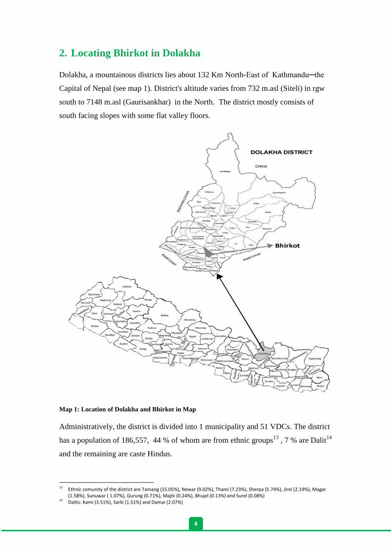
2. Locating Bhirkot in Dolakha
Dolakha, a mountainous districts lies about 132 Km North-East of Kathmandu─the
Capital of Nepal (see map 1). District's altitude varies from 732 m.asl (Siteli) in rgw
south to 7148 m.asl (Gaurisankhar) in the North. The district mostly consists of
south facing slopes with some flat valley floors.
Map 1: Location of Dolakha and Bhirkot in Map
Administratively, the district is divided into 1 municipality and 51 VDCs. The district
has a population of 186,557, 44 % of whom are from ethnic groups13
, 7 % are Dalit14
and the remaining are caste Hindus.
13 Ethnic comunity of the district are Tamang (15.05%), Newar (9.02%), Thami (7.23%), Sherpa (5.74%), Jirel (2.19%), Magar
(1.58%), Sunuwar ( 1.07%), Gurung (0.71%), Majhi (0.24%), Bhujel (0.13%) and Surel (0.08%) 14 Dalits: Kami (3.51%), Sarki (1.51%) and Damai (2.07%)
5
Dolakha district received Swiss aid from early 1960s through an integrated hill
development project. The district was also connected to the national road network
back in the 1970s through Swiss funding. This brought the opportunity for market
access and people with road access shifted into more commercial activities especially
potato and vegetable cultivation and livestock production. The majority of the villages
of the district are now connected to the road network. However, most (67%)
households in the district still practice subsistence agriculture and paddy, maize,
wheat, millet, barley and potato are the major crops grown (DDPRP, 2011).
Bhirkot VDC [500 – 800 m.asl] the case study site is 25 Km by road south and
downhill from Charikot (District Headquarter of Dolakha, 1300 m.asl) and lies on a
south facing slope on the eastern banks of the Tamkosi river. The VDC has been
characterised as one of the most vulnerable VDCs15
to flood induced landslides, in
the District Disaster Prepardness and Response Plan (DDPRP) prepared by DDMC.
About 600 households live in the VDC, the majority of whom are from the so called
higher caste (17% Brahmin caste, 49% Chettri caste). Fiveteen percent of the
population are dalit (low caste) and 19 % come from ethnic groups. The major ethnic
groups in the VDC are Newar, Bhujel and Majhi. Most of the dalit people live in ward
3 which lies on a steep slope with an unstable structure. Similarly, people from the
Majhi ethnic group lives in area with south-west facing steep slope which is dry
compared to other areas of the VDC. Traditionally, the Majhi community used to fish
and provide boat services on the Tamakoshi river as major source of their livelihood.
Now, there is bridge in Tamakoshi river and fishing contributes only small part of
their livelihood. Their major occupation is now agriculture and wage labour. The
Majhi and the Dalit are poorer in terms of economic condition and marginalized in the
village politics.
The main occupation of the village households is agriculture (60%) and livestock is
an integral part of this. Other major income sources are wage labor (33%), service
(13%) and business (3%). A total of 405 people are working outside the village, of
which 80 people are working abroad and remitting income to their households.
15 Out of 51 VDCs of the district, 21 VDCs are indentified as most vulnerable to floods and landslides. It is based on the
available evidence of human casualities, affected people and affected households of the VDCs from 1971 to 2010.
6
The road from Tamakoshi to Manthali which was black topped a few years ago passes
through Bhirkot along the side of the Tamakoshi river. A feeder road connecting the
blacktopped road to the neighbouring VDC (Jhule) climbs from the river side up the
slope through ward 8 of Bhirkot. The road was constructed using 'labour‐
based, environmentally friendly and participatory methods with decentralised system
s'16
with support from a Swiss funded project called the District Road Support Project
(DRSP). Besides this, there is a road track opened across ward 8 and 3 of Bhirkot
which goes to neighbouring VDC of Jhule.
Bhirkot VDC has six schools (Budi Chandika Primary school, Indrawati Lower
Secodary School, Bhieshwor Secondary School, Gaiyaswori Primary School, Ganesh
Secondary School, Narayani Higher Secondary School), a healthpost for primary
health care, three cooperatives who fulfill the role of rural banks (Bhimeswor
Women’s Development Saving and Credit Cooperative, Bhimeswor Multipurpose
Coopervative and Sidheswor Women’s Saving and Credit Cooperative) and three
CFUGs (Shideswori CFUG (ward 8), Bhudi Devi CFUG (ward 4), and Asare CFUG
(ward 7)17
.
3. The origins of the Bhirkot landslide
The accounts of village informants located the origins of the 2012 landslide not in the
heavy rainfall of August 6th
but in a deeper history. According to them in 1985/86 the
Government of Nepal planned a road linking Ramechhap (the District Headquarter of
Ramechhap district) to the Lamosangu-Jiri road and conducted a survey for the road
alignment. The proposed 124 km road needed to cross Bhirkot. However the survey
team identified a specific area of Bhirkot as structurally unstable and prone to
landslides. The planned road was therefore aligned across the upper part of the
village, avoiding the structurally unstable area at the lower part of the slope. The
villagers were informed about the structurally unstable area and of the fact that the
land was proably slipping by about 10 cm per year. A road track was opened in the
following years but it was not completed until the Khimti Hydroelectricity Project
was initiated in 1993.
16 Starkey, P., Tumbahangfe, A. and Sharma, S. 2013. Building Roads and Improving Livelihoods in Nepal. District Road
Support Porgram, Swiss Agence for Development and Coorporation, Nepal. 17 2008. Village Profile and Situation Analysis. Bhirkot VDC Office, Dolakha
7
The Khimti Hydropower project that came to be built downstream of Dolakha on the
Tamakishi river was Nepal's first privately-funded hydropower facility. Having a 60
Mega Watt (MW) facility it was built at Kirne on the border between Dolakha and
Ramechhap. The construction required an access of road from Nayapul (a small town
on bank of Tamakohsi river where road to Jiri passes) to Kirne.
The Khimti Hydroelectricity Project started road construction in 1993. According to
the villagers of Bhirkot, the particular road section in Bhirkot was sub-contracted to
Ram Chandra Upreti who was the DDC member representing Nepali Congress at the
time. A man named Kiran was the project manager and another person, a Bengali
named Ranjan Gosh was the soil technician for the road. The contractor changed the
original alignment and sought to construct the road across the structurally unstable
area on the grounds that it would reduce the length of the road by about 2.5
kilometers. The reduction in the length of the road was seen to decrease construction
costs and the distance for the project to transport heavy equipment and construction
materials. The villagers reported that they protested about this change arguing that the
new alignment would trigger a landslide and affect their settlement and agricultural
land upslope. However, the project ignored this protest and started the construction
using heavy equipment (excavators) and explosives.
The villagers reported that they protested about the construction work and they also
formed a delegation team and went to Kathmandu to put their concern to the ruling
political party18
and requested them to stop the road construction on this new
alignment. The team met the then Minister of Agriculture (Ram Chandra Paudel from
the Nepalese Congress) and Bhim Bahadur Tamang (a politician representing
Dolakha), but this had no effect. The villagers kept protesting and blocked the work
for three months. Eventually the contractor managed to break the blockade using
hired thugs and brought in the police in July 1993. In the view of the villagers the
contractor used his political connections and bribed the local politicians and the
police. The villagers claimed that the contractors bribed the thugs by giving them 4
buffalo, 3 goats and 10 muri19
of raksi (a locally brewed alcohol). The villagers (of
ward 8) also were of the view that the hydropower project bribed the district
government officials (including politicians) to get the permission to construct the road
according to the new alignment.
18 At that time Nepali Congress was in the government. 19 1 Muri= 87.215 liter
8
After being beaten by the thugs, the villagers filed the case in August 1993 in the
Supreme Court, with the help of a local lawyer named Bed Prasad Sivakoti, against
the hydropower company. But no hearing happened on the case. The villagers blamed
the government for not taking up the case.
The villagers fears that the road construction might triggered a landslide in the
Kalidaha area of Bhirkot were realised. In 1995 a huge landslide occured and washed
away a section of the road and since then each year the road has been blocked by
landslips during monsoon season. It has affected transportation to the Hydropower
project as well as movement of many people from Ramechhap, Okhaldhunga and
parts of Dolakha districts. The landslide came to be known as the 'Kalidaha' landslide.
As a result the Hydropower project had to permanently position an excavator at the
landslide site during the monsoon season in order to clear the road immediately when
landslides occured. The Project also invested in building a retaining wall to stabilize
the landslide but to no effect. The landslide used to wash the road in each monsoon.
The problem remained for five years until the landslide was stabilized using bio-
engineering. When the road was blocked due to a landslide, local people used to work
as porters to carry the luggage of passengers and goods from one edge of the landslide
to other. However district level informants blamed the villagers, who worked as
porters in carry luggage across the landslide area, for triggering the landslide by
irrigating their paddy fields. According to a local politician interviewed in Charkot in
July 2013, the local community decided to address the problem themselves with
support from the district administration. The Siddshwori Community Forest User
Group was established to plant trees in the landslide area and grazing was restricted in
the area. This apparently helped regenerate vegetation in the area which helped
stabliize the landslide. The Road department constructed a water drainage and
retaining wall along the road. The politician further added that the local political
leaders urged the porters to stop pouring watering onto the head of the landslide area.
The landslide was stabilized by 1999.
9
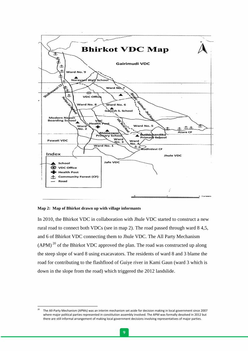
Map 2: Map of Bhirkot drawn up with village informants
In 2010, the Bhirkot VDC in collaboration with Jhule VDC started to construct a new
rural road to connect both VDCs (see in map 2). The road passed through ward 8 4,5,
and 6 of Bhirkot VDC connecting them to Jhule VDC. The All Party Mechanism
(APM) 20
of the Bhirkot VDC approved the plan. The road was constructed up along
the steep slope of ward 8 using exacavators. The residents of ward 8 and 3 blame the
road for contributing to the flashflood of Guiye river in Kami Gaun (ward 3 which is
down in the slope from the road) which triggered the 2012 landslide.
20 The All-Party Mechanism (APMs) was an interim mechanism set aside for decision making in local government since 2007
where major political parties represented in constitution assembly involved. The APM was formally desolved in 2012 but there are still informal arrangement of making local government decisions involving representatives of major parties.
10
4. The August 2012 flashflood and landslide
4.1. Description of event (effects and immediate response from
household)
On 6th
August 2012, a heavy rainfall occurred in the evening and it lasted for more
than four hours. It triggered landslips and a flashflood in the Bhirkot VDC. In ward 8,
a landslip at about 10 pm from the upper slope destroyed a house and buried two
people (one women and her granddaughter) inside it. Her husband was away from the
village at the time (Interview 5 August 2013). The house collapsed and buried both
the wife and grand-daughter who were sleeping inside the house. When the husband
came back he saw his collapsed house and heard the voices of his wife and
granddaughter from inside the ruins. He called his neighbours for help. They came
and removed the debris and rescued the women and her granddaughter. They were
severely injured and rushed to Kathmandu hospital for treatment.
The heavy rainfall also triggered flashfloods in the rivers of Bhirkot . One such
flashflood occured in Guiye river of Kami Gaun (ward 3) and destoyed the house of
Thirtha BK who lived on the bank of the river Fortunately, the family of Thirtha BK
was able to escape and save their lives but they lost belongings and livestock
including 1 buffalo and 6 goats in this incident. The flashflood also washed away all
of their fields and destroyed crops (paddy and millet). The neighbors gathered
immediately after the incident (at about midnight) helping the family to take out some
of their remaining belongings from the debris. During the interview conducted in 6
August 2013, Tirtha BK and fellow villagers of Kami Gaun stated that the flash flood
was triggered by the rural road constructed by the VDC which passed above the
village . They said that the road was constructed using excavators which destablized
the area and no proper water drainage system was installed which caused the water to
concentrate along the road when it rained and this triggered the flashflood.
Many other houses in the VDC were also affected (partially damaged) by the rainfall
of that day. The flashflood also destroyed public properties such as the drinking water
supply (intake and pipes destroyed), three schools and a healthpost. The Narayani
Higher Secondary School was more affected with complete destruction of a four room
building and partial damage to two other buildings. Similarly, three buildings were
11
partially damaged and a two room toilet building was destroyed at Bhimeshwor
Primary School which is located on the bank of Adheri Khola (stream). The building
of a private primary school called Mordern Nepal Boarding School (ward 2) located
on the side of the Adherikohla was also completely destroyed. The flood also
destroyed crops (paddy, maize and millet) growning on more than 5 hectares of
agriculture land.
Finally the flashflood destroyed a part of road linking Charikot to Ramechhpa
(Pushpalal highway) and blocked transportation.
4.2. Response to disaster:
On the day after the flashflood, members from the DDMC- Red Cross, DDC, Chief
District Officer (CDO), District Soil Conservation Office (DISCO), APM member -
and local Journalists visited the village and surveyed the damage. The DDMC
distributed relief materials to the affected villagers. The Red Cross provided tents,
utensils, blankets and other relief materials to them and the DDC and CDO provided
Rs. 5000 per family to two households whose house was completely destroyed. The
team asked the rest of the family whose houses were partially damaged to visit the
district office with a recommendation letter from the VDC office to get support from
the relief fund.
The Red Cross officials suggested to some of the households from Kami gaun (the
Dalit village of ward 3), which were located on the steep slope of the village, that they
should leave their houses and stay in safer places. The officials hinted that further
rainfall might cause an even bigger flashflood. They recommended that the
households should move to Budidevi community forest which lies in ward 4. In the
beginning, the Budidevi CFUG officials resisted the proposal, but later they agreed to
allow the affected households to temporarily stay in community forest area. Some of
the families including the families whose house were completely damaged (the
families of Tirtha BK and Krishna Karki) got shelter in their relatives or neighbours
house. After three months, when the monsoon period was over and the festival season
started, the villagers started going back to live in their own houses.
12
4.3. Early recovery
Neighburhood and community support
Some neighbours of the affected people from Kami Gaun (ward 3) formed an ad hoc
committee to gather relief materials (grain, clothes etc) to support their neighbours
who were affected by the flashflood. They provided 10 Muri (640 kgs) of grain to
Tirtha BK's family whose house was destroyed and who lost belongings and food
reserves.
The Siddheshwori CFUG which is largest CF in the VDC with Sal timber21
offered
free of charge timber to repair or rebuild houses of the affected households. The
Bhimeswor cooperative of the VDC provided Rs. 5000 compensation money to the
two households whose households were completely destroyed. The cooperative also
provided loans at a subsidised interest rate to the affected households and the two
families received a loan to rebuild their house.
The Siddshwork CFUG also provided timber free of charge to the two public schools
affected from the flashflood to reconstruct their buildings.
Government and external support:
The affected households who did not get the the DDC relief money during DDMC’s
visit after the landslide, had to pay visit to DDC office in Charikot (about 25
Kilometer from Bhirkot which takes about one hour by bus) with a recommendation
letter from the VDC to get the relief fund. They said they had to go through lengthy
bureaucratic processes to get the money and had to stay in Charikot for few days.
They spent almost all that they received (NRs 5000) on travel to and accomodation in
Charikot. After hearing of this experience, many other villagers from ward 8 where
many houses were partially destroyed by the landslide dropped the idea of going to
Charikot to get relief payments.
Public property including the school and healthpost were among the most affected by
the flashflood. The Head master and officials from school management committee of
Narayani Higher Secondary School of ward 9 approached the DDC, District
Education Office, DISCO and a few non-government organizations for support to
21 There are three CFs in the VDC- i) Siddheswori CF, ward 9 (99.94 Ha and 282 member HHs), ii) Budidevi CF, ward-4 (29.12
Ha and 77 member HHs) and iii) Asare CF, ward 7 (53.63 Ha and 55 member HHs).
13
rebuild the damaged school buildings. A NGO called Rural Reconstruction Nepal
(RRN) which had been working in the village supported the building of a pre-school
which was used for primary classes. They used their political/personal networks to
connect to the Education minister and office of the Prime Minster to get support. Due
to this effort the Water Induced Disaster Management Division22
, Bhaktapur provided
support to construct a retaining wall to protect the school building (95 pieces of
gabion nets and funds and technical support to build the retaining wall). The
Education Ministry through the District Education office granted funding of Rs.
24,000,00 to construct a new building for the secondary school. The VDC provided
Rs. 411,000 from VDC office as support to the school. Construction work is now
underway for a new four room concrete building. The authorities also approached
DDC and DISCO office to support the building of the school and divert the stream.
The authorities promised to allocate some budget for the next fiscal year as the budget
allocation for 2012 had already been made.
Similarly, the Bhimeswor Primary school of ward 3, whose toilet block was destroyed
and suffered partial damage to three buildings (six rooms) from the flash flood also
got support of Rs. 500,000 from District Education Office and Rs. 40,000 from the
VDC office to repair the buildings. The DISCO provided 40 gabion nets to build a
diversion wall to control the gully. The school principle complained that they had not
yet get any support from District Disaster Management Committee even though they
came after the disaster to survey the damage of the school.
4.4. Later Responses
Most of the people whose agriculture land was covered by the landslide removed the
debris on their own in the following winter and got part of their land ready for
cultivation. They could not recover the land washed down by the flashflood.
In the annual village council meeting held in January 2013, which prepares the annual
plan of the village, the council members approved the allocation of some of the
village annual budget for the construction of a canal along the sides of the rural road
(constructed above the village area) to drain excess water during rainy season.
Furthermore, the affected people appeal DDC and DISCO to provide bagion boxes
and financial support in order to control gully to prevent further damage to the crop
field and settlement. However, the district organizations provided support for only the
schools and health posts but not to the individual households.
22 It is a division under Ministry of Irrigation. In total there are seven such divisions and 5 subdivision across the country. It
works to stabilze stream and river banks for controling water induced disaster inlcuding flood. Bhaktapur office is responsible for Dolakha district.
14
5. Consequences of flashflood
5.1. Recovery from disaster increased burden to the affected
household
The households who were affected from the flashflood of August 2012 are now
recovering gradually and trying to forget the event. The relief package including NRs
5000 provided by DDC and utensils and clothes provided by the Red Cross was only
a minor contribution to cope with the immediate effects of the shock. The households
who had not got the DDC relief fund in the village and were asked to visit district
office for relief did not bother since the support provided would not cover the cost of
visiting the district. In this sub-section, we present the accounts of two affected
households focusing on their struggle to recover from the landslide.
Thirtha BK is one of the residents of the Dalit settlement in Kami Gaun along with
22 other Dalit households. His house was located along the side of Guiye River (dirty
stream) where his family (wife and four children) were sleeping on the night of 6th
August 2012 when the Guiye River’s flashflood washed away his house. He was
away from home in Qatar for employment during the time.
The flashflood destroyed his house, killed cattle and they lost most of their
belongings including crops. His family took refuge in their relative's home. Tirtha was
informed about the incident and immediately came back to Nepal quiting his job in
Qatar about 2 months later. His family got Rs. 5000 money from the DDC, Rs. 5000
from the VDC office and another Rs. 5000 from the Shidhewori Cooperative of the
VDC. The Red Cross office gave the family tents, utensils and blankets. His
neighbours collected grain for him.
When Tirtha arrived, he was heart broken and decided to leave the village and move
to Kathmandu and stay there in a rented room and start life again. But, his neighbours
and relatives requested him to stay in the village. He was not able to deny their
request and started rebuilding his home. He got a loan to rebuild the house from the
VDC’s Bhimweshwor Cooperative and bought land from a Chhetri villager23
for Rs.
600,000 and build his house there and started cultivating again. Shideswori CF gave
23 He commented that the land he bought had earlier belongs to the Dalits but the Chhetri's had taken it from them by
manipulating and increasing loans that they could not repay
15
10-15 cft timber free of charge for his building construction. At present he has loan of
Rs. 1,500,000 and does not know how he is going to pay back the loan.
Krishna Karki's family although better-off than the Tirtha's family, had a similar
story. His family consisting of three members (including his wife and granddaughter)
lives in ward 8 of Bhirkot. His son and daughter-in-law live and work in Kathmandu.
As noted earlier, Krishna's house was destroyed by 6 August 2012 heavy rainfall
causing landslip. Krishna's wife and granddaughter were severely injured and were
taken to Kathmandu for treatment. In an interview in August 5 2013, Krishna's wife
reported that she still feels scared during heavy rain and cannot do hard labor. Her
granddaughter have not yet recovered from the injuries and is staying with her parents
in Kathmandu. She told that her granddaughter is still under medication and not fully
recovered from the shock.
The family removed debris from wreckage of their house and rebuilt it the following
winter. They moved to new house in February 2013. Until then, they were staying in
their neighbours' house. They took loan of Rs. 600,000 loan from the Bhimeswor
Cooperative for treatment and the building new house. Siddshwori CFUG provided
timber to construct the house free of charge. The only support they got were from
government were relief material from Red Cross, Rs 5000 from DDMC and 5000
from VDC which was basically for immediate relief.
Both families did not get any significant support from district level agencies for
recovery from the disaster. They managed to build new house and get settled but with
the burden of a loan from the local cooperative. They appreciated the support from
neighbours and local level institutions especially CFUG and cooperative but they
were worried about paying back the loan.
5.2. Support of community institutions and neighbours was
significant
The support of community institutions and neighbours to the disaster affected
households was significant for both immediate relief and recovery. The neighbours
were the ones to rescue the affected people. They also provided shelter to those who
lost their houses.
16
The local cooperative provided Rs 5000 for two affected households and offered
loans for them to build or repair their houses. In interviews, these households shared
their feelings about this saying it was really the greatest help for them at a time of
crisis. The two households discusseda above whose houses were completely
destroyed took a loan from the cooperative which they got access with relative ease.
They could not imagine getting a loan from any other financial institution easily.
Similarly, Siddheshwori CFUG provided timber free of charge to build new house or
repair the damaged house. In an interview with CFUG executive committee members
in 6 August 2013, they said that it was the responsibility of the group to help their
member when they were in crisis.
In Tirtha BK's case, who was abroad working in Qatar during the incident the help
from neighbour and relatives were enormous. The neighbours (who were his relatives
too) collected grain which helped to feed his family for few months.
5.3. How and why did school get more external support and not the
affected households?
Of the three schools affected (Narayani Higher Secondary School, Bhimeshwor
Primary School and Mordern Nepal Boarding School), in terms of scale of damage
Narayani Higher Secondary School was the greatest compared to the other two .
The Narayani Higher Secondary School was able to generate support to rebuild the
school buildings from multiple sources using their social and political networks.
Compared to the primary school, the Narayani Higher Secondary school got a higher
level of support from district and national level government agencies and NGOs. The
private school did not got any support and was found closed in August 2013 visit. The
Headmaster of Narayani school ( interview in 5 August 2013) shared that he used his
political and professional connections to get access to district and national level
agencies and got support to reconstruct the school buildings. Besides his connections,
local politicians from the Bhirkot also put their effort for generating the support. The
main reason why they gave more emphasis to this school was that it is the only Higher
Secondary school of the VDC.
17
5.4. Government response to disaster and changes
The District Disaster Preparedness and Response Plan24
(DDPRP) of Dolakha gives
the mandate to DDMC members including DDC, District Administration Office, Red
Cross and other district level government and non-government agencies to respond to
disasters. The plan focused on two aspects: disaster preparedness and response. The
preparedness is more of an early-warning system and the response largely focuses on
immediate relief. The DDC has a disaster relief fund of amount NRs 200000 which it
used for this relief. Similarly, the Red Cross provides relief material (utensils, cloths,
blanket, tent etc).
Besides the DDPRP mandate of immediate relief under DDRC, some district level
organizations have specific roles related to disaster prevention and recovery. For
example, the DFO has the role to reduce the risk of forest fires and the Water Induced
Disaster Management Division is responsible for minimizing damage from flooding
through the construction of river embankments and retaining walls. Similarly, DISCO
works on managing watersheds to prevent soil erosion and small landslides through
small scale bio-engineering structures (e.g. check dam and planting bamboo and
broom grass etc). There are some NGOs working in the district to support on disaster
response. For instance, ECARDS Dolakha is working on disaster preparedness and
the development of an early warning system.
However, in case of Bhirkot, the support from the district level government agencies
including the DDRC was found to be minimal in terms of recovery of the affected
households from the disaster. The DDRC including the Red Cross provided a 'relief
package'. Only two household received the NRs 5000 immediate relief fund at the
village and others were asked to visit DDC office in Charikot.
Only two public schools got support from Ministry of Education through the District
Education Office to construct new school buildings and gabion nets from the Water
Induced Disaster Reduction Office and DISCO for diversion of stream. Besides this,
individual affected households have not got support from the district agencies for
recovery from the disaster.
The VDC provided Rs. 411000 to Narayani Higher Secondary School and Rs. 40000
to Bhimeshwor Primary School.
24 DDMC 2011. District Disaster Preparedness and Response Plan, Dolakha. District Disaster Management Committee,
Dolakha.
18
5.5. Heavy rainfall since 2013 and its affects:
In August 2013 there was also a heavy rainfall in Bhirkot and the surrounding VDCs.
The rainfall triggered a flashflood in the Guiye river and Adhnari khola and blocked
the Pushpalan Highway for about a week. A flood in Dholikhola, a river bordering the
Bhirkot VDC with Jafe VDC partly damaged a bridge on the Pushpalan highway and
a diversion was made so that vehicles could cross. The flood also blocked the
Tamakoshi River forming a dam.
In 2014 there were no major storms or further landslides. The April 2015 earthquake,
and in particular its aftershocks caused severe damage in Dolokha including Bhirkot.
However no major landlides took place in Bhirkot VDC recently after earthquake.
6. Discussion
The Bhirkot flashflood in terms of damage to life and property as shown in this case
could be seen as a minor event in relation to other bigger disaster events that have
happened in other parts of the country. These include the Seti flashflood (Kaski
District, north West Nepal) that occured in May 2012 which caused 40 deaths and
major damage downstream (Pokhara) to property and the Darchula flood (in the Far
West of Nepal) of June 2013 that affected the district headquarters destroying
government offices and private buildings. However, the case of Bhirkot is an
example of the small but regularly occuring disasters the happen in the mid-hills of
Nepal that affects daily life and livelihoods of people. Although there has been no
landslide since 2012 the chances are that at some future date there will be another.
However government action has been limited to the immediate response to the 2012
events and since then little attention has been given to Bhirkot. Households have
largely been left to fend for themselves and as show above had incurred significant
debts in doing so.
These small but recurrent disasters have not received the attention of the experts and
Kathmandu-based government agencies who ranked the districts for disaster risk and
prioritize programs. In the process of developing NAPA the Dolakha district has been
ranked as one of the most 'vulnerable' districts (GoN 2010) due to to threat of Tsho
Rolpa GLOF which is an ‘existential threat’ and the UNDP is working to mitigate this
with a project in a group of northern VDCs in the district. National planning processes
19
related to disaster risk management appear to be poorly based on actual experience of
disaster and small but recurrent events that cumulatively create a significant risk
environment.
The Bhirkot case also reveals that badly planned infrastructure development such as
link road to Khimti Hydropower project in 1993 which later developed as Puspalal
Highway and in recent years construction of unplanned rural road construction in the
mid-hills driven by political interest have been an underlying cause of landslides.
Increasingly heavy rainfall events have simply triggered the disaster rather than being
the cause of them.
In recent years VDCs have received about NRs 2 million rupees a year from Ministry
of Federal Affaires and Local Development most of which has been used in rural road
construction, mostly using equipments (excavators). Their construction appears to be
drive more by VDC and village level political leader considerations with little
atteniton to environmental planning or construction standards and maintenance
practices.
At the local level, when disasters such as the flash flood of August 2012 occured in
Bhirkot, community institutions and neighbours are the one who have most
effectively supported the affected people (even without being trained or the creation
of a village level disaster management plan). This suggests that despite the high
degree of social differentiation in the village, there is sense of a collective social
contract among the community institutions to support fellow villagers.
On the other hand, the support from government agencies including the mechanisms
responsible for disaster risk management - the DDRC - has been limited and hard to
access due to laborious bureaucratic processes. Access to government support is
largely determined by personal connections through political networks to the national
rather than district level (cross-scalar connections) as happened in case of Narayani
Higher Secondary School.Marginalized households (such as the Dalits) who do not
have political access to influence government decision making processes have almost
no chances to get support to recover from the disaster.
20
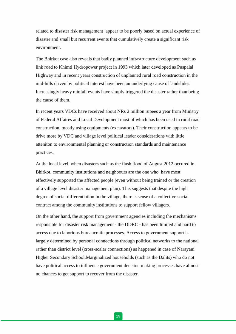
Annex 1: List of Key informant interview
Date Name of the person Name of the Organization/place
21st Feb, 2013 Kali Prasad Parajuli District Administrative Office, CDO
22nd
. Feb , 2013 Durga Shrestha District Soil Conservation office (DISCO)
22nd
Feb , 2013 Harka Bahadur
Shrestha
Red Cross Dolakha, Chair person
22nd
Feb, 2013 Durga Bahadur Dura Ecology, Agriculture and Development
Society (ECARDS), ED
22nd
Feb , 2013 Rameshwor Manandhar Federation of Nepalese Chambers of
Commerce and Industry (FNCCI), Dolakha,
Chair Person
23rd
Feb , 2013 Aulaka Ale Division Road Office, official
23rd
Feb, 2013 Punya Prasad Subedi Irrigation Federation, Dolakha Branch, Chair
Person
23rd
Feb, 2013 Yuv Raj Pandey District Agriculture and Development Office
(DADO), Officer
23rd
Feb, 2013 Tubraj Pokheral District Development Office, LDO
Jagdish Aryal District Development Office, Audit officer
24th Feb, 2013 Villagers Mirge VDC
25th Feb, 2013 Villagers Bhirkot VDC
26th Feb, 2013 Villagers Sundrawati VDC
21
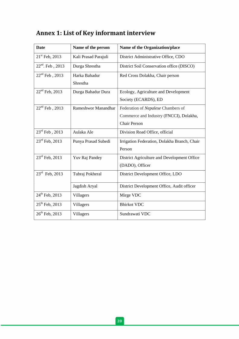
Annex 2: List of interview
Date Name of the organization Name of the person
5th August 2013 Bhirkot Mapping, Bhirkot-2
5th August 2013 Narayani Higher Secondary School,
Bhirkot-9
Yaga Bahadur KC,
Principle
5th August 2013 Management Committee member,
Narayani Higher Secondary School,
Bhirkot-8
Paudel
5th August 2013 landslide affected person-8 Karki woman
6th August 2013 Health Post, Bhirkot -3
6th August 2013 Bhimeshwor Secondary School, Bhirkot-3 Sudip Thapa, Principle
6th August 2013 Landslide affected person, Teacher,
Bhirkot-3
Pradeep BK
6th August 2013 Landslide affected person, neighbor,
Bhirkot-3
Dal Bahadur BK
6th August 2013 Landslide affected person, Bhirkot-3 Tirtha BK
7th August 2013 Shideswori CF treasurer, Bhirkot-3 Sudip Thapa
7th August 2013 Meeting at FECOFUN
8th August 2013 VDC Sub-secretary Mahesh Dahal
8th August 2013 DDC Narayan Shedai
8th August 2013 DISCO Dhurga Shrestha
9th August 2013 Red Cross Harka Bahadur Shrestha
9th August 2013 CPN-UML Rishi Kesh Upreti
10th August 2013 Back to Kathmandu
10 Feb 2015 CFUG Sandip Thapa
10 Feb 2015 CPN UML VDC president Ganendra Raj KC
10 Feb 2015 Health Post Incharge Dal Bahadur karki
11 Feb 2015 President Bhimeshor Cooperatives Shyam Kaji Katuwal –
11 Feb 2015 Victim of landslide Tirtha BK
11 Feb 2015 Narayani Higher Secondary School
teacher
Dev Das Shrestha
1
Published by:
ForestAction Nepal
Bagdol, Lalitpur, Nepal T: +977-1-5001362/5001144/1620069
E: [email protected] www.forestaction.org
Southasia Institute of Advanced Studies Baneshwor, Kathmandu, Nepal
T: +977-1-4469801 E: [email protected]
www.sias-southasia.org
In collaboration with:
Danish Institute for International Studies Copenhagen, Denmark www.diis.dk