the planning inspector appointed by the government to of... · extg brook forms extg agriculture...
TRANSCRIPT


The Planning Inspector appointed by the Government to examine our plan has said that it is not sound because …
• Not satisfied that the housing target is high enough
• Need to increase housing on urban extensions around the ‘principal urban area’
Council is now proposing to:
- Increase the number of homes at Edwalton by 550 to 1,750
- Increase the number of homes south of Clifton by 500 to 3,000
- New allocation east of Gamston to include 2,500 new homes to 2028, rising to around 4,000 in total.

Tell us about the site

Aim of this exercise The aim of this exercise is to confirm and add to our understanding of
the issues affecting the site, and the areas that local people think should be protected/could be developed.
We presented a focus group with maps and photos of the site. The group gave us their feedback on the parts of the site they considered
most sensitive and in need of protection and also those they considered could be freed up for development.
Now it’s your turn! Have a look at the comments made by the focus group. Let us know if you agree/disagree and why. Please make your comments on the
post it notes provided.


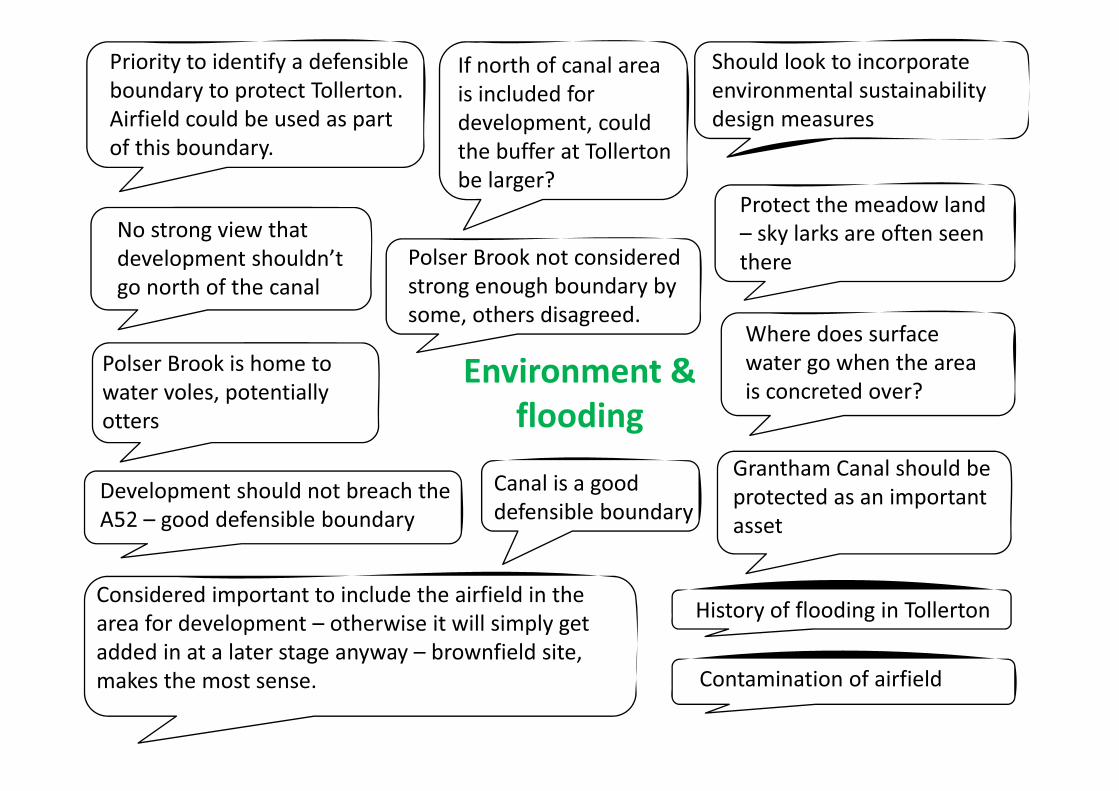
Environment &flooding
If north of canal areais included fordevelopment, couldthe buffer at Tollertonbe larger?
No strong view thatdevelopment shouldn’tgo north of the canal
Where does surfacewater go when the areais concreted over?
History of flooding in Tollerton
Contamination of airfield
Priority to identify a defensibleboundary to protect Tollerton.Airfield could be used as partof this boundary.
Should look to incorporateenvironmental sustainabilitydesign measures
Grantham Canal should beprotected as an importantasset
Considered important to include the airfield in thearea for development – otherwise it will simply getadded in at a later stage anyway – brownfield site,makes the most sense.
Development should not breach theA52 – good defensible boundary
Polser Brook not consideredstrong enough boundary bysome, others disagreed.
Canal is a gooddefensible boundary
Polser Brook is home towater voles, potentiallyotters
Protect the meadow land– sky larks are often seenthere

Transport, accessand infrastructureAlready a problem along
Tollerton Lane. Pressureneeds to be taken offthis congested route.
Access needs to beimproved on the widerroad network (not justfocused on routes intoNottingham), link toM1 etc.
Barrier of A52 – connectivityissues. It would be verydifficult to integrate any newdevelopment because ofthis. New access across theA52 would be needed (3access points as a minimum)
If the development is tohave employment to enablepeople to work close towhere they live why does itneed to be on the edge ofNottingham?
Real concernsabout connectivitywith Gamston
The A52 has traffic issues, thedevelopment must avoid peoplerat running through the site toavoid the A52
Employmentshould be sitednear the A52
A retirement village as part ofthe site would alleviate sometraffic problems as it would beself contained
If a new bus service was promisedthere would need to be certaintythat this would be retained
Query as to whetherTollerton Lane could bewidened as part of anydevelopment
Impact of collierytraffic must beconsidered –cumulative impact
Concern that without rerouting the roads thedevelopment is notfeasible, most householdshave 2 cars

Housing and Localcommunityimpacts
Primary school wouldbe needed to servethe development andpotentially asecondary school also
Accept that affordablehousing is needed but30% could be too high
The Airfield’s permission foremployment and hospital should beprotected for as long as possible
Important to consider themobile home park as it willbe located right in themiddle of the developmentpotentially
Heritage assets aroundTollerton
Need to protectthe allotments orprovide analternative

Ideas andOpportunities
Could there be a busgate on Tollerton Lane?
A gypsy pitch could besited adjacent to thecouncil depot (but not inthe flood plain)
Edwalton Golf Coursesuggested fordevelopment. Movegolf course toopposite side of A52.
Suggestion to includearea to the north of thecanal but move southernboundary further northto increasing buffer toTollerton.
Plant trees to make a defensibleGreen Belt boundary for Tollerton
Should this be a standalone settlement orshould it integrated withthe existing community?
Highways depot suggested aspotentially suitable fordevelopment – close to A52 andring road, least impact on Tollertonor Bassingfield
Listed Pill Boxes – needconsidering as part of any scheme
Housing layout/density/mixneeds to be established up frontas to protect area from greaterland take. There should be a mixof densities.
Could access be restrictedthrough to Tollerton fromthe new development?
Suggestion thatTollerton Lanecould be linked toLings Bar acrossthe fields
Fourth bridge acrossTrent would potentiallymake this developmentmore desirable to some.
Improve access across the ringroad – the junction at Morrisons– awful at the moment
Block off access from Bassingfieldto the A52

Where should the additional
housing go?

Aim of this exercise IF the site is to be developed, where should that development go?
There are 3 options to consider.
The Council’s preferred approach is Option 2 which uses the airfield, keeps a degree of separation with Bassingfield and Tollerton and makes Grantham Canal the northern limit of development.
There may be other options. Some of the workshop groups have made suggestions which you may support, or you may have your own suggestion.
Please feel free to suggest alternative options on a comment sheet and hand it to a member of staff.

�
Which option do you prefer?
Please use a sticker to indicate your preference.
You may wish to comment further or have ideas that we have not considered, if so, please complete a comments sheet and hand it to a member of staff or take a Freepost envelope and post it back to us. We realise that you may not support any of the options, but it would still be helpful to know your views should the development
go ahead
�
�

OPTION 1


OPTION 2: Around 4,000 homes (2,500 before 2028) THE COUNCIL’S PREFERRED APPROACH
Positives:
• Includes the airfield, which is classed as a brownfield site. Part of the area has planning permission for a business park, which could be a source of local employment.
• Grantham Canal and Polser Brook are features which would provide a new defensible Green Belt boundary.
• Grantham Canal Corridor could provide green space and recreation opportunities.
• More able to support infrastructure improvements (than Option 1).
• Would provide development options beyond 2028, which in turn would reduce the need to further review the Green Belt in future years.
Negatives:
• Loss of airfield?
• Impact on setting of listed pillboxes
• Could have significant impact on Tollerton Mobile Home Park
• Areas of higher land (i.e. around Little Lane and to the west of the airport)
• More potential impact on existing infrastructure

OPTION 2

OPTION 1: Around 2,500 homes
Positives:
• Adjacent urban area of Nottingham (Gamston).
• Planning permission granted for business park nearby, which could be a source of local employment.
• Less impact on existing infrastructure as smaller area of development than larger options.
• Only one identified environmental constraint – the Grantham Canal has a local nature conservation designation.
Negatives:
• Crosses potential defensible Green Belt boundaries of Tollerton Lane and Grantham Canal.
• Areas of higher land to the south (i.e. around Little Lane and to the west of the airport)
• Less able to support major infrastructure improvements (e.g. transport improvements).
• May affect airfield operations

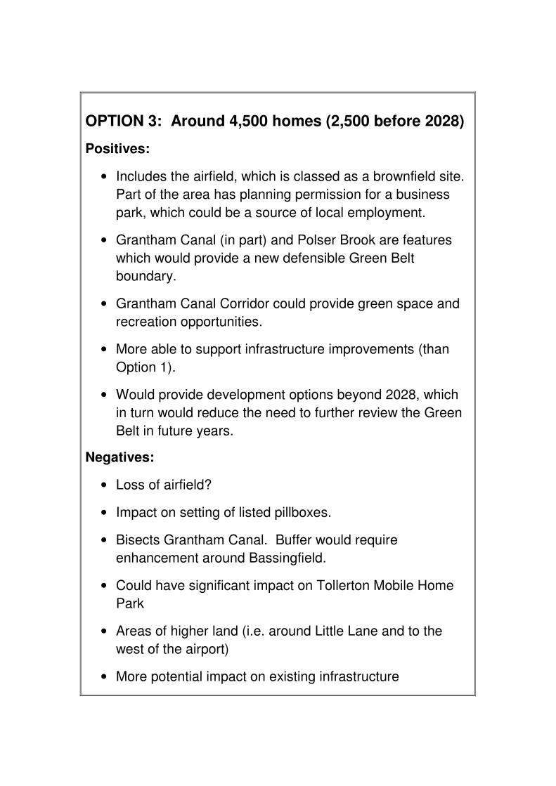
OPTION 3

�
OPTION 3: Around 4,500 homes (2,500 before 2028)
Positives:
• Includes the airfield, which is classed as a brownfield site. Part of the area has planning permission for a business park, which could be a source of local employment.
• Grantham Canal (in part) and Polser Brook are features which would provide a new defensible Green Belt boundary.
• Grantham Canal Corridor could provide green space and recreation opportunities.
• More able to support infrastructure improvements (than Option 1).
• Would provide development options beyond 2028, which in turn would reduce the need to further review the Green Belt in future years.
Negatives:
• Loss of airfield?
• Impact on setting of listed pillboxes.
• Bisects Grantham Canal. Buffer would require enhancement around Bassingfield.
• Could have significant impact on Tollerton Mobile Home Park
• Areas of higher land (i.e. around Little Lane and to the west of the airport)
• More potential impact on existing infrastructure

ANOTHER OPTION?

NB: SOME MEMBERS OF THE WORKSHOP GROUPS WERE NOT IN FAVOUR OF ANY DEVELOPMENT ON THE SITE. HOWEVER, ON THE BASIS THAT DEVELOPMENT WERE TO HAPPEN SOME MEMBERS OF THE GROUPS MADE THE FOLLOWING SUGGESTIONS ALTHOUGH THERE WAS NO OVERALL CONSENSUS OF OPINION

WORKSHOP SUGGESTION
A


WORKSHOP SUGGESTION
B


OPTION C (additional suggestion from
workshop member)

1a
new A52 access
LocalCentre
to Radcliffe on Trent
1b
2a
2b
3a
3b
30 Ha
14 Ha
19 Ha
6 Ha 45 Ha
30 Ha Nett Areas ( 80% gross )
Bassingfield 44 Ha1a 30 Ha1b 14Ha
South of Canal 25 Ha2a 6 Ha2b 19 Ha
Airfield 75 Ha3a 30 Ha3b 45 Ha
Industry Commercial AFU 10 Ha
Local Centre / Commercial B1 21 Ha
Note : an allowance for primary school not shownpending clarification of requirement
Assume Average Housing Density is 35 units / HaZoning of housing areas eg a, b, c etc allows different housing styles and local identity
New landscape / woodland planting barrier
Industry /Commercial
Travellersite 10 units
Edge of Village( Sign )
Traffic Control
Tollerton Parkretained
New landscapedcorridor along Canal
phys
ical b
arrier
slop
e
Extg Agriculture
TollertonBoundary
Aerodrome usedis-continued
Supermarket
NORTH
Golf Links
Golf Links
Extg Agriculture
Extg Sport /Leisurefacilities in Flood Plane
allotments
barrier slope Grantham Canal
Grantham
Canal
Extg UrbanEdge
Extg Agriculture
Extg Agriculture
Extg
bro
ok fo
rms
boun
dary
Connectivity
Connectivity
DensityMelton Road, Edwalton (Sharphill)For comparison, this is a site of about 107 hectares to the south of Edwalton, to theeast and west of the A606 Melton Road. It would be primarily residential, comprisingof about 1,200 houses but including provision for a new school, associatedcommercial uses and employment development. The developers are also proposingto designate some land around Sharphill as a 'community park'
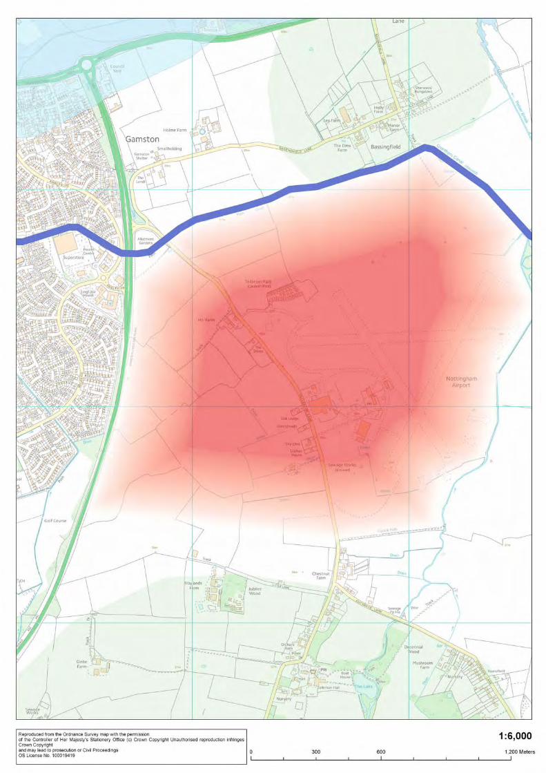
The total Gamston proposal shown is circa 355 hectares including landscaped areasand it is expected that the density will be similar to that found currently in Gamstonand West Bridgford, but suggests that in excess of 3500 units is a realistic option thatcan be achieved to satisfy the Planning Inspector's requirments.
200m / 1000'
INDICATIVE PLAN FOR DISCUSSION ONLYLAND EAST OF GAMSTON / NORTH TOLLERTON
wildlife corridor green area adjacent canal
New landscape /woodland planting barrier
KEYAREA OF DEVELOPMENT / HOUSES
ACCESS ROADS
WILDLIFE CORRIDOR
WATERWAYS
GREEN BUFFER PROTECTING VILLAGES
INDUSTRY / COMMERCIAL

What should the
development look like?

Aim of the exercise If development happens, what might go where? A mock-up of
a ‘concept’ plan for the site has been created as a starting point for discussion. The workshop group considered this
plan and gave us their opinions.
Now it’s your turn
Tell us what we’ve got right and/or wrong. Tell us if we’ve missed anything critical to the success of the development.
Please use a feedback form to provide us with your comments. You may wish to use the blank site plan to show
us how you consider the development should be laid out. Please hand your completed form to a member of staff or
take a Freepost envelope and post it back to us.

Possible concept plan
Development Zones
Built development focusedOn and around the Airfield, to include:• 4000 new buildings• 20 ha employment• New local centre• Schools• Hospital• Community Parks• Sports facilities
New local centre

It was noted that thereis an oil pipeline acrossthe site – this wouldneed to be protectedand strip left eitherside of it.
Impact on villages: TollertonLane not suitable for largeincrease in traffic
Suggestion to include areato the north of the canalbut move southernboundary further north toincreasing buffer toTollerton.
The Airfield’s permissionfor employment andhospital should beprotected for as long aspossible.
Requirement is for 2 and 3bedroom houses – push for asmuch Affordable Housing aspossible to meet needs of localpeople.
Employment – better locatednear the A52 so lorries etcwouldn’t need to drive into thedevelopment.
Really deep green bufferrequired between newdevelopment andTollerton – howeverthere was concern thatonce created thiswouldn’t be lookedafter/maintained. Wouldneed someconsideration.
Grantham Canalshould beprotected as animportant asset
Bottlenecks already aproblem alongTollerton Lane. Pressureneeds to be taken offthis congested route.
Concern that oldTollerton might get cut offfrom the rest of Tollertonif the suggested MasterPlan was implemented.
Airfield could be used aspart of Tollertondefensible boundary.
Polser brook not considered strongenough boundary by some, othersdisagreed.
Barrier of A52 – connectivity issues.It would be very difficult to integrateany new development because ofthis. New access across the A52would be needed.
Comments on the indicative new masterplan

Thoughts onthe proposedmasterplan?
Do you agree withthe proposed openspace provision?What open spaceprovision would youlike to see?
What are your thoughts on acommunity park? What wouldyou like to be incorporatedinto a community park?
Should thedevelopment cross thecanal to the north?
What schoolprovision wouldyou like to see? Doyou agree with theproposed locationof the school?
What outdoorrecreation/ sportsfacilities would youlike to see andwhere?
What local servicesdo you think areimportant as part ofthe proposedhousing scheme?
What are yourthoughts onroad layoutand locations?
Do you thinkthat the sitehas enoughvehicle access?What accessdo you thinkshould beprovided?
What cycle andpedestrianprovision wouldyou like to seeand where?
Do you agreewith thelocation ofthe localcentre?
What would you liketo see in the localcentre?
What are yourthoughts onproposedemploymentdevelopment on thesite?
What is your opinionof the proposed sitelayout? Is thereanything you wouldchange about thehousing locations??
How do you feel the site relatesto existing housing in WestBridgford/ Gamston
Do you have any thoughtson the layout of residentialareas and green spaces?
Do you feel the airport shouldbe developed for housing orretained?
Do you agree with theproposed locations foremployment?
What healthcareprovision do you feelshould be provided?
What are your thoughts on aGrantham Canal County Park?
Are there any areaswhere you feeldevelopment shouldbe avoided?
Do you have any thoughts on siteboundaries and buffer zones?

Known infrastructureprovision
Transport provision may include:• Direct connection to be made to the A52. • Public transport improvements, including a 15 minute
frequency bus service and a park & ride.Transport modelling is underway to help identify further requirements.What transport requirements do you consider should be incorporated into the scheme?
Transport
Areas of flood risk identified in the Gamston and Tollerton area. Appropriate mitigation would be required. ‘Sustainable Drainage Systems’ and above ground balancing areas may be required
Flooding & Flood Risk
Specific requirements are not currently identified, although the advice of Rushcliffe Clinical Commissioning Group is that there would be a need to extend Gamston medical practice to serve possible development in the Gamston area. What are your views on healthcare provision?
Health
Educationprovision
Local centre already provided on the edge of existing Gamston development. Accessibility will need to be improved linking the new development to this local centre. What community provision would you like to see as part of the revised proposals? What services would you like to see in the local centre? Where do you feel the local centre should be?
Green space and habitat enhancement required within the site and along its boundaries in line with the landscape actions contained within the Greater Nottingham Landscape Character Assessment. Opportunities for enhancement along the Grantham Canal. What green space provision would you like to see and where?
Green space andnatural habitats
Emergencyservices
Subject to further research
Community Services
Gas- No abnormal requirements identifiedWater- further research required, waste water requires further hydraulic modellingIT-no abnormal requirementsElectricity-Reinforcement of 33kv network and the provision of primary 33/11kv substationWaste- no abnormal requirements
Primary and secondary provision likely to be required within the site. What do you feel should be considered as part of the scheme? Where do you think a primary school could belocated? If a secondary school is needed, where should it be located?

Oct2012
Nov2012
TimelineCouncil submitted CoreStrategy (part 1 of Local Plan)for public examination
9,600 new homes (2011 2026)proposed, including2,500 East of Gamston(eventually rising to 4000)
Why has the housingfigure been increased?Q
Rushcliffe’s PlanningInspector states the plan isnot sound
The inspector was not satisfiedthat RBC has planned to fullymeet housing need, and thecouncil is advised that thehousing target should beincreased (in agreement withother Housing Market Areaauthorities).

17 June –9 Aug2013
May –Sept2013
Timeline
What about trafficissues?Q
Public Consultation on thepreferred approach to extrahousing growth, as outlinedabove
Following advice from the Inspector, the Council believe that there is aneed to:• increase housing on urban extensions around the ‘principal urbanarea’ i.e. West Bridgford, Edwalton and Clifton
• Review the Green Belt, including considering the removal of land• from Green Belt to help meet needs beyond plan period (up to 2028)• Increase the rate of housing delivery early in the plan period• Extend the plan period (previously 2011 to 2026) to 2028
We arehere
Undertake supporting workand transport assessments
Assessments and modelling will beundertaken to establish the likelyimplications of development on trafficand transport networks. The outcomesof these will be used to informdecision making on what transportmeasures should be implemented

Oct2013
NovDec2013
Dec2013
Timeline
Will there be furtherconsultations?Q
Report to Cabinet and fullCouncil with proposedmodifications to Core Strategy
Submit proposed modificationsto Planning Inspector
Comments from consultationswill be used to inform decisionmaking on proposedmodifications
Consult on proposed majormodifications (subject toadvice from Inspector)
Submit representations onmodifications to PlanningInspector

Early2014
MayJune2014
TimelineExamination hearings(Inspector’s decision)
Adoption of Core Strategy byCouncil (anticipated)