the nineteenth century the twentieth century …btckstorage.blob.core.windows.net/site2324/parkwood...
TRANSCRIPT

PARKWOODSPRINGSFrom deer park to
country park?
THE NINETEENTH CENTURY
The economic management of the woodlands continued throughout the nineteenth century as shown by the late Victorian photograph of a charcoal maker standing beside his hut at the top of Old Park Wood. The wigwam-shaped hut covered by turves was the traditional home of the charcoal maker who lived deep in the woods during the
coaling season. However, the woods were near the end of their economic life and were being converted into ‘high forest’, made up entirely
of single-stemmed trees.
The western edge of Old Park Wood was severed from the rest of the wood in 1845 by the Manchester, Sheffield and Lincolnshire Railway which involved the construction of the impressive viaduct over Herries Road. The woodlands were also being eaten into on all sides by quarrying and mining activities.
In 1857 Wardsend Cemetery came into existence. A few years later in March 1864 the low land beside the River Don was devastated by the flood waters from the collapsed Dale Dyke Reservoir in the upper Loxley valley. The swirling water crashed against the gates of the cemetery. Nearby two couples and their children narrowly escaped drowning by somehow making their way into Old Park Wood.
Perhaps the greatest change in the area in this century was the creation of a new industrial colony – Parkwood Springs. By 1861 it contained 171 houses and had a population of 792. It was a very mixed community in terms of the birthplaces and occupations of its population. Among the adult males (206), for example, 130 were employed in the metal trades of whom 87% were Sheffield-born, but among railway workers 19 of the 20 were born elsewhere in the country. The majority employed in miscellaneous trades were also in-migrants to Sheffield including one from Portugal!
1890
THE TWENTIETH CENTURY
AND BEYOND
By the time of the 1901 census the settlement at Parkwood Springs had almost trebled in size to 2,263. Many of the adult males (43%) were still employed in the metal trades and 31% in railway related work. There were also grocers, carters, 23 gas workers, a few working in various capacities on the electric tram car system, two policemen, one clergyman and one ‘scavenger’ (refuse collector). Of those employed in the metal trades most (200 out of 248) were Sheffield-born whereas those employed in railway-related work were largely born outside Sheffield (139 out of 179).
During the Second World War a quarter of the houses were destroyed or damaged beyond repair by bombing. But the houses were not rebuilt and the sites were either left partly derelict or occupied by industrial users. There were promises of redevelopment but by the 1970s people were being re-housed as far away as Mosborough. And soon Parkwood Springs as a settlement ceased to exist.
Shirecliffe Hall was also damaged by bombing in the Second World War and was subsequently demolished in 1963. The last burial in Wardsend Cemetery took place in 1977 and it was officially closed in 1988.
Wallace Road, Parkwood Springs
Great swathes of Old Park Wood disappeared in the early twentieth century following an agreement with the Duke of Norfolk’s estate to tip ash from the power station at Neepsend in the area formerly covered by woodland. Ordnance Survey maps of 1923-24 and 1935 show extensive areas of tipped ash dispatched to the former woodland by aerial ropeway. Landfill operations began in the 1970s in the abandoned quarry and still continue covering a large part of the central area. Neepsend electricity power station was de-commissioned in the early 1970s and Neepsend Brick Works closed in 1978. The railway was last used for passengers in January 1970 and was then downgraded to become a single track branch line serving Stocksbridge Steel Works. The ski village was established towards the end of the 1980s.
The area is now a mosaic of acid grassland and meadow where bare ground has been recently colonised, open woodland dominated by birch and multi-stemmed oak and areas of planted trees, both native and exotic. The only areas of ancient woodland to remain are Rawson Spring and Scraith Wood. Outside the landfill area large stretches of ground are covered by heathland vegetation (bracken, broom, gorse, heather and bilberry) that reflect the dry and acid conditions of the area. Among flowering plants to look out for, in the appropriate season, are bluebell, wood sage, foxglove, hawkweed, vetch, poppy, knapweed and rosebay willowherb. The area also has a rich and varied animal life. There are rabbits and foxes and birdlife is prolific. In winter there are mixed parties of tits and finches. In late spring and early summer the song of chiffchaffs and willow warblers may be heard. Sparrowhawks, kestrels and green woodpeckers may also be seen. Grasshoppers are common and among the butterflies that may be seen are common blue, meadow brown and small and large skipper. The colourful moth, the six-spot burnet, is also common.
Grasshopper
Six-spot Burnet
moth
WardsendCemetery
Sculptureby Jason
Thomson
Heather, spreading in the dry, acid conditions
Scraith Wood
BeaconProject
PARKWOOD SPRINGS TODAY
KEY:L.P.T.F. = Little Pear Tree Field Nature Reserve
= Public Rights of Way
THE SEVENTEETH AND EIGHTEENTH CENTURIES
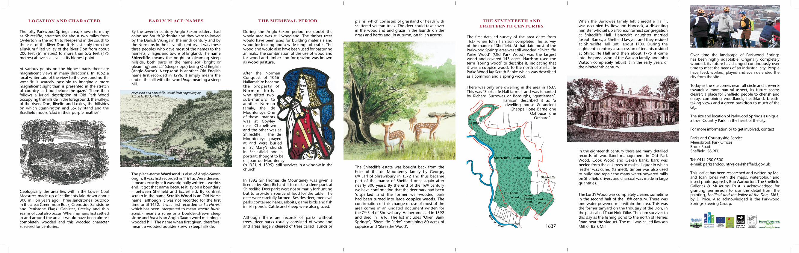
The first detailed survey of the area dates from 1637 when John Harrison completed his survey of the manor of Sheffield. At that date most of the Parkwood Springs area was still wooded. ‘Shirtcliffe Parke Wood’ (Old Park Wood) was the largest wood and covered 143 acres. Harrison used the term ‘spring wood’ to describe it, indicating that it was a coppice wood. To the north of Shirtcliffe Parke Wood lay Scrath Banke which was described as a common and a spring wood.
There was only one dwelling in the area in 1637. This was ‘Shirtcliffe Hall farme’ and was tenanted by Richard Burrowes or Boroughs, ‘gentleman’.
Harrison described it as ‘a dwelling house & ancient
Chappell one Barne one Oxhouse one
Orchard’.
When the Burrowes family left Shirecliffe Hall it was occupied by Rowland Hancock, a dissenting minister who set up a Nonconformist congregation at Shirecliffe Hall. Hancock’s daughter married Joseph Banks, a Sheffield lawyer, and they resided at Shirecliffe Hall until about 1700. During the eighteenth century a succession of tenants resided at Shirecliffe Hall and then about 1775 it came into the possession of the Watson family, and John Watson completely rebuilt it in the early years of the nineteenth century.
LOCATION AND CHARACTER
The lofty Parkwood Springs area, known to many as Shirecliffe, stretches for about two miles from Owlerton in the north to Neepsend in the south to the east of the River Don. It rises steeply from the alluvium filled valley of the River Don from about 200 feet (61 metres) to more than 575 feet (175 metres) above sea level at its highest point.
At various points on the highest parts there are magnificent views in many directions. In 1862 a local writer said of the view to the west and north-west ‘it is scarcely possible to imagine a more magnificent sight than is presented in the stretch of country laid out before the gaze.’ There then follows a lyrical description of Old Park Wood occupying the hillside in the foreground, the valleys of the rivers Don, Rivelin and Loxley, the hillsides on which Stannington and Loxley stand and the Bradfield moors ‘clad in their purple heather’.
EARLY PLACE-NAMES
By the seventh century Anglo-Saxon settlers had colonised South Yorkshire and they were followed by the Danish Vikings in the ninth century and by the Normans in the eleventh century. It was these three peoples who gave most of the names to the hamlets, villages and towns of England. The name Shirecliffe means the bright or gleaming steep hillside, both parts of the name scir (bright or gleaming) and clif (steep slope) being Old English (Anglo-Saxon). Neepsend is another Old English name first recorded in 1296. It simply means the end of the hill with the word hnip meaning a steep hill.
THE MEDIEVAL PERIOD
During the Anglo-Saxon period no doubt the whole area was still woodland. The timber trees would have been used for building materials and wood for fencing and a wide range of crafts. The woodland would also have been used for pasturing animals. The combination of the use of woodland for wood and timber and for grazing was known as wood pasture.
After the Norman Conquest of 1066 Hallamshire became the proper ty of Norman lords who gifted two sub-manors to another Norman family, the de Mounteneys. One of these manors was at Cowley near Chapeltown and the other was at Shirecliffe. The de Mounteneys prayed at and were buried in St Mary’s church in Ecclesfield and a portrait, thought to be of Joan de Mounteney (b.1321, d. 1395), still survives in a window in the church.
In 1392 Sir Thomas de Mounteney was given a licence by King Richard II to make a deer park at Shirecliffe. Deer parks were not primarily for hunting but to provide a source of food for the table. The deer were carefully farmed. Besides deer, medieval parks contained hares, rabbits, game birds and fish in fish-ponds. Cattle and sheep were also grazed. Although there are records of parks without trees, deer parks usually consisted of woodland and areas largely cleared of trees called launds or
plains, which consisted of grassland or heath with scattered veteran trees. The deer could take cover in the woodland and graze in the launds on the grass and herbs and, in autumn, on fallen acorns.
Geologically the area lies within the Lower Coal Measures made up of sediments laid down about 300 million years ago. Three sandstones outcrop in the area: Greenmoor Rock, Grenoside Sandstone and Penistone Flags. Ganister, fireclay and thin seams of coal also occur. When humans first settled in and around the area it would have been almost completely wooded and this wooded character survived for centuries.
The place-name Wardsend is also of Anglo-Saxon origin. It was first recorded in 1161 as Wereldesend. It means exactly as it was originally written – world’s end. It got that name because it lay on a boundary – between Sheffield and Ecclesfield. By contrast scraith in the name Scraith Wood is an Old Norse name although it was not recorded for the first time until 1452. It was first recorded as Scryhcrest which has been interpreted to mean screath-hurst. Screith means a scree or a boulder-strewn steep slope and hurst is an Anglo-Saxon word meaning a wooded hill. The name when first given, therefore, meant a wooded boulder-strewn steep hillside.
Neepsend and Shirecliffe. Detail from engraving by S. and N. Buck, 1745.
The Shirecliffe estate was bought back from the heirs of the de Mounteney family by George, 6th Earl of Shrewsbury in 1572 and thus became part of the manor of Sheffield once again after nearly 300 years. By the end of the 16th century we have confirmation that the deer park had been ‘disparked’ and the former well-wooded park had been turned into large coppice woods. The confirmation of this change of use of most of the area comes in an undated document written for the 7th Earl of Shrewsbury. He became earl in 1592 and died in 1616. The list includes ‘Oken Bank Springe’, ‘Shercliffe Parke’ containing 80 acres of coppice and ‘Skreathe Wood’.
In the eighteenth century there are many detailed records of woodland management in Old Park Wood, Cook Wood and Oaken Bank. Bark was peeled from the oak trees to make a liquor in which leather was cured (tanned); timber was also used to build and repair the many water-powered mills on Sheffield’s rivers and charcoal was made in large quantities.
The Lord’s Wood was completely cleared sometime in the second half of the 18th century. There was one water-powered mill within the area. This was the former tanyard on the tributary of the Don, in the past called Toad Hole Dike. The dam survives to this day as the fishing pond to the north of Herries Road near the viaduct. The mill was called Rawson Mill or Bark Mill. 1637
Over time the landscape of Parkwood Springs has been highly adaptable. Originally completely wooded, its future has changed continuously over time to meet the needs of an industrial city. People have lived, worked, played and even defended the city from the site.
Today as the site comes near full circle and it reverts towards a more natural aspect, its future seems clearer: a place for Sheffield people to cherish and enjoy, combining woodlands, heathland, breath- taking views and a green backdrop to much of the city.
The size and location of Parkwood Springs is unique, a true ‘Country Park’ in the heart of the city.
For more information or to get involved, contact
Parks and Countryside ServiceMeersbrook Park OfficesBrook RoadSheffield S8 9FL
Tel: 0114 250 0500e-mail: [email protected]
This leaflet has been researched and written by Mel and Joan Jones with the maps, watercolour and insect photographs by Bob Warburton. The Sheffield Galleries & Museums Trust is acknowledged for granting permission to use the detail from the painting, Sheffield and the Valley of the Don, 1863, by E. Price. Also acknowledged is the Parkwood Springs Steering Group.
Sheffield &Rotherham
Parkwood Landfill
Action Group