the mystery of lost trail pass · the mystery of lost trail pass lewis and clark trail heritage...
TRANSCRIPT
The Mystery of Lost Trail Pass
Lewis and Clark Trail Heritage Foundation, Great Fall, Montana., 2000
Fazio, James (Ed)
Contributing Authors:
Robert N. Bergantino
J. Wilmer Rigby
Hadley B. Roberts
Steve F. Russell
James R. Wolf
ISBN: 0-967887-1-9
CHAPTER FROM
The Mystery of Lost Trail Pass
Lewis and Clark Trail Heritage Foundation, Great Fall, Montana., 2000
Applying the Tools of Reason and Technologyby Steve F. Russell
Pages 39-67
This documents my research methods for finding the Lewis and Clark Trail over
the mountains.
Citation: Russell, Steve F., “Applying the Tools of Reason and Technology”
in The Mystery of Lost Trail Pass: A Quest for Lewis and Clark's Campsite of
September 3, 1805, James Fazio (Ed), Lewis & Clark Trail Heritage
Foundation, Incorporation, Great Falls, Montana, 2000. ISBN100967888719
Lewis and Clark over Lost Trail Pass
Applying the Tools of Reason and TechnologyApplying the Tools of Reason and TechnologyApplying the Tools of Reason and TechnologyApplying the Tools of Reason and Technologyby Steve F. Russell
(Draft Edition, April 30, 1998, Rev: 9-17-98, Rev: 12-28-99)
TABLE OF CONTENTS (DRAFT)TABLE OF CONTENTS (DRAFT)TABLE OF CONTENTS (DRAFT)TABLE OF CONTENTS (DRAFT)
Introduction . . . . . . . . . . . . . . . . . . . . . . . . . . . . . . . . . . . . . . . . . . . . . . . . . . . . . . . . . 1
Previous Route Analysis (1988-89) . . . . . . . . . . . . . . . . . . . . . . . . . . . . . . . . . . . . . . . 1
Current Research Methodology and Results (1997) . . . . . . . . . . . . . . . . . . . . . . . . . 2
Ordering of Geographic Clues - Reason and Technology . . . . . . . . . . . . . . . . . . . . . 3Segment-1 . . . . . . . . . . . . . . . . . . . . . . . . . . . . . . . . . . . . . . . . . . . . . . . . . . . . . 5Segment-2 . . . . . . . . . . . . . . . . . . . . . . . . . . . . . . . . . . . . . . . . . . . . . . . . . . . . . 5Segment-3 . . . . . . . . . . . . . . . . . . . . . . . . . . . . . . . . . . . . . . . . . . . . . . . . . . . . . 5Segment-4 . . . . . . . . . . . . . . . . . . . . . . . . . . . . . . . . . . . . . . . . . . . . . . . . . . . . 10
Summary of the Proposed Route and Modern Maps . . . . . . . . . . . . . . . . . . . . . . . . 10Final Table of ordered Geographic Reference Points . . . . . . . . . . . . . . . . . . 10Final Route Description with Maps . . . . . . . . . . . . . . . . . . . . . . . . . . . . . . . . 10
Bibliography . . . . . . . . . . . . . . . . . . . . . . . . . . . . . . . . . . . . . . . . . . . . . . . . . . . . . . . 13
APPENDIX Õ From the Journals . . . . . . . . . . . . . . . . . . . . . . . . . . . . . . . . . . . . 14September 1, 1805 (Sunday) "Bluff Point" . . . . . . . . . . . . . . . . . . . . . . . . . . 14September 2, 1805 (Monday) "Dismal Swamp" . . . . . . . . . . . . . . . . . . . . . . 14September 3, 1805 (Tuesday) "Head of a Cove" . . . . . . . . . . . . . . . . . . . . . . 16September 4, 1805 (Wednesday) "Eoote-lash-Schute Nation" . . . . . . . . . . . 19
VERSIONS1. 2.
Lewis and Clark over Lost Trail Pass ÕÕÕÕ Applying the Tools of Reason and Technology ÕÕÕÕ 1
1 The author is on the electrical engineering faculty at Iowa State University.
Copyright 1998 Steve F. Russell
Lewis and Clark over Lost Trail Pass
Applying the Tools of Reason and TechnologyApplying the Tools of Reason and TechnologyApplying the Tools of Reason and TechnologyApplying the Tools of Reason and Technologyby Steve F. Russell1
(Draft Edition, April 30, 1998, Rev: 9-17-98, Rev: 12-28-99)
IntroductionIntroductionIntroductionIntroduction
During September 1-4, 1805, the Corps of Discovery under the command of Lewisand Clark bushwacked their way northward over the dividing ridge between thewaters of what they called Lewis' River on the south and Clark's River on the north.They began on the Salmon River in Idaho and their destination was the BitterrootRiver in Montana. They were not following an established Indian trail because theychose to go due north over the most direct route possible. The established Indiantrail, at that time, looped eastward through the Big Hole before going northward upTrail Creek, over Gibbons Pass, and then into the Bitterroot Valley.
The route of the Corps of Discovery over Lost Trail Pass is, to repeat an often usedphrase, "a puzzle wrapped in a mystery, shrouded by an enigma." It remains amajor challenge to the Lewis and Clark trail community to determine their routefor September 1-4, 1805 and their September 2nd and 3rd camping sites. This paperreports on a technique the author has developed, using topography and computeranalysis techniques, that can be applied to the Lost Trail route.
For the past 12 years, I have been doing research on the Lolo Trail from Lolo,Montana to Weippe, Idaho. This work is nearing completion and will result in theaccurate location and documentation of the trails within the Lolo Trail System: theNorthern Nez Perces Trail, the Bird-Truax Trail, and the Lewis and Clark route.The research techniques developed for the Lolo Trail were applied to the Lost Trailroute using modern map data and the expedition*s journal narratives and maps.While the Lolo Trail research results were validated by cross-checking with manyother historical sources, as well as ground truthing, no known equivalent resourcesexist for the Lost Trail route. The party "bushwhacked" their way over the pass anddid not follow an established "roade." Without the remnants of a well-travelledIndian trail, we are left with only their journal records and the topography to be ourguide.
Lewis and Clark over Lost Trail Pass ÕÕÕÕ Applying the Tools of Reason and Technology ÕÕÕÕ 2
Copyright 1998 Steve F. Russell
Previous Route Analysis (1988-89)Previous Route Analysis (1988-89)Previous Route Analysis (1988-89)Previous Route Analysis (1988-89)
In 1988, I prepared a map display for the Montana 1989 Centennial celebrationwhich is now in the Bitter Root Historical Society museum in Hamilton, Montana.At that time, my estimate of the route up the North Fork of the Salmon was basedentirely on reading the journals and studying the Clark maps and comparing bothto modern topography. I hadn*t yet developed the good computer analysistechnique or done field research.
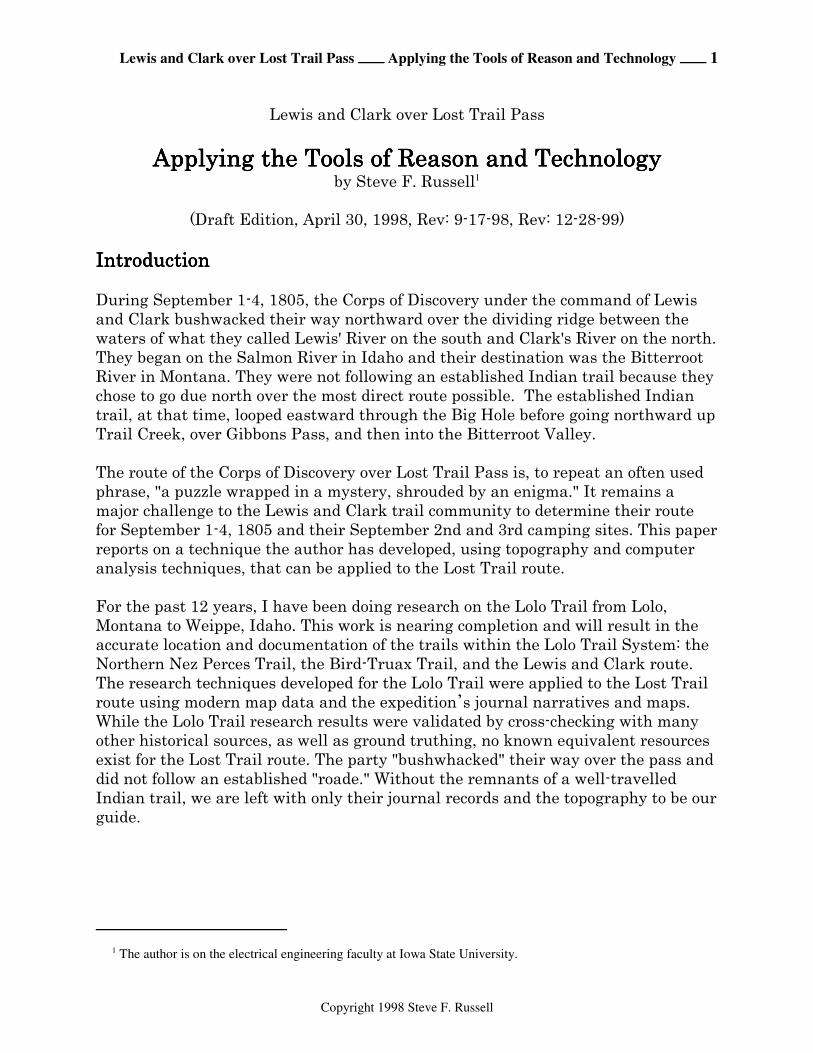
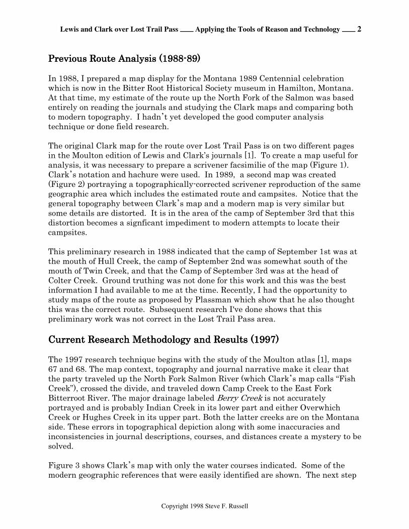
The original Clark map for the route over Lost Trail Pass is on two different pagesin the Moulton edition of Lewis and Clark’s journals [1]. To create a map useful foranalysis, it was necessary to prepare a scrivener facsimilie of the map (Figure 1). Clark*s notation and hachure were used. In 1989, a second map was created(Figure 2) portraying a topographically-corrected scrivener reproduction of the samegeographic area which includes the estimated route and campsites. Notice that thegeneral topography between Clark*s map and a modern map is very similar butsome details are distorted. It is in the area of the camp of September 3rd that thisdistortion becomes a signficant impediment to modern attempts to locate theircampsites.
This preliminary research in 1988 indicated that the camp of September 1st was atthe mouth of Hull Creek, the camp of September 2nd was somewhat south of themouth of Twin Creek, and that the Camp of September 3rd was at the head ofColter Creek. Ground truthing was not done for this work and this was the bestinformation I had available to me at the time. Recently, I had the opportunity to study maps of the route as proposed by Plassman which show that he also thoughtthis was the correct route. Subsequent research I've done shows that thispreliminary work was not correct in the Lost Trail Pass area.
Current Research Methodology and Results (1997)Current Research Methodology and Results (1997)Current Research Methodology and Results (1997)Current Research Methodology and Results (1997)
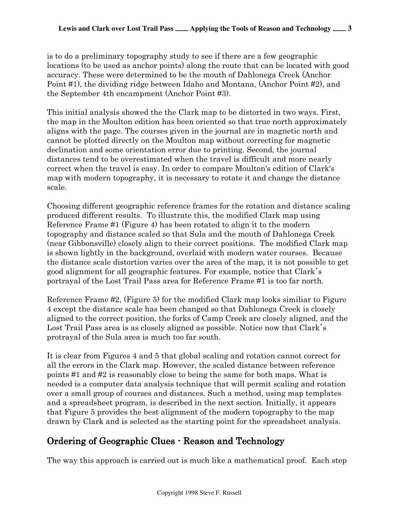
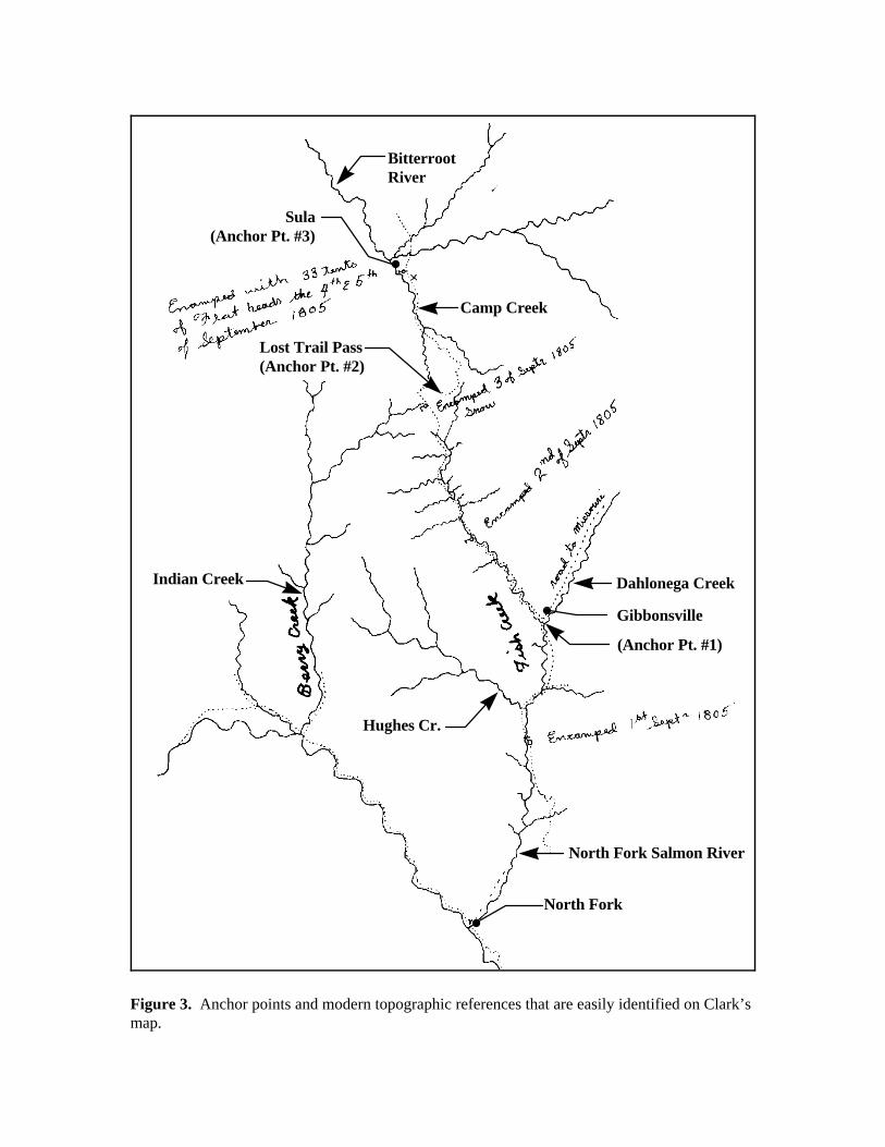
The 1997 research technique begins with the study of the Moulton atlas [1], maps67 and 68. The map context, topography and journal narrative make it clear thatthe party traveled up the North Fork Salmon River (which Clark*s map calls “FishCreek”), crossed the divide, and traveled down Camp Creek to the East ForkBitterroot River. The major drainage labeled Berry Creek is not accuratelyportrayed and is probably Indian Creek in its lower part and either OverwhichCreek or Hughes Creek in its upper part. Both the latter creeks are on the Montanaside. These errors in topographical depiction along with some inaccuracies andinconsistencies in journal descriptions, courses, and distances create a mystery to besolved.
Figure 3 shows Clark*s map with only the water courses indicated. Some of themodern geographic references that were easily identified are shown. The next step
Lewis and Clark over Lost Trail Pass ÕÕÕÕ Applying the Tools of Reason and Technology ÕÕÕÕ 3
Copyright 1998 Steve F. Russell
is to do a preliminary topography study to see if there are a few geographiclocations (to be used as anchor points) along the route that can be located with goodaccuracy. These were determined to be the mouth of Dahlonega Creek (AnchorPoint #1), the dividing ridge between Idaho and Montana, (Anchor Point #2), andthe September 4th encampment (Anchor Point #3).
This initial analysis showed the the Clark map to be distorted in two ways. First,the map in the Moulton edition has been oriented so that true north approximatelyaligns with the page. The courses given in the journal are in magnetic north andcannot be plotted directly on the Moulton map without correcting for magneticdeclination and some orientation error due to printing. Second, the journaldistances tend to be overestimated when the travel is difficult and more nearlycorrect when the travel is easy. In order to compare Moulton's edition of Clark'smap with modern topography, it is necessary to rotate it and change the distancescale.
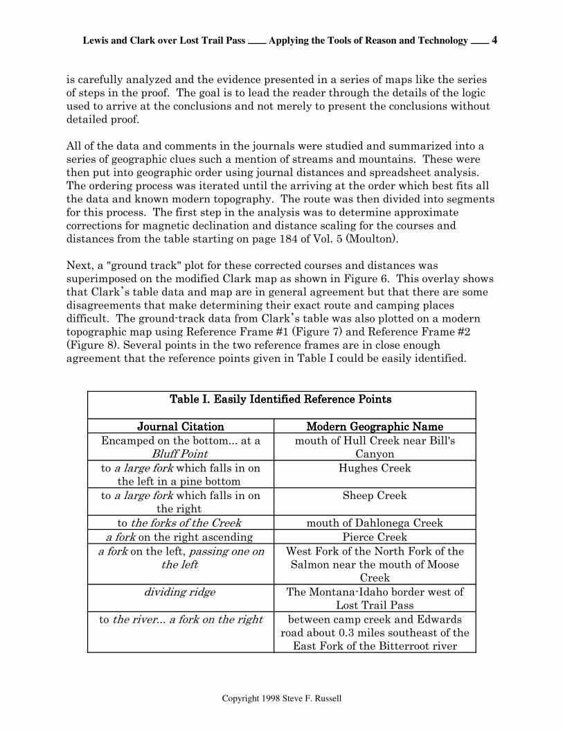
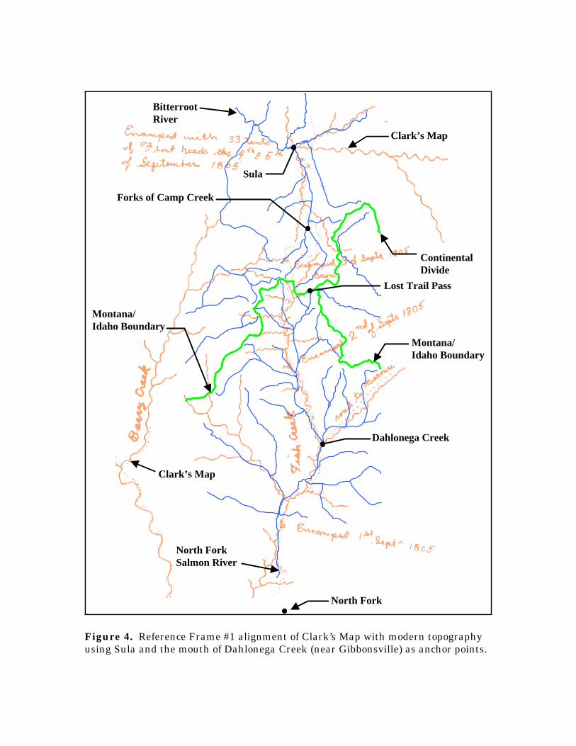
Choosing different geographic reference frames for the rotation and distance scaling produced different results. To illustrate this, the modified Clark map usingReference Frame #1 (Figure 4) has been rotated to align it to the moderntopography and distance scaled so that Sula and the mouth of Dahlonega Creek(near Gibbonsville) closely align to their correct positions. The modified Clark mapis shown lightly in the background, overlaid with modern water courses. Becausethe distance scale distortion varies over the area of the map, it is not possible to getgood alignment for all geographic features. For example, notice that Clark*sportrayal of the Lost Trail Pass area for Reference Frame #1 is too far north.
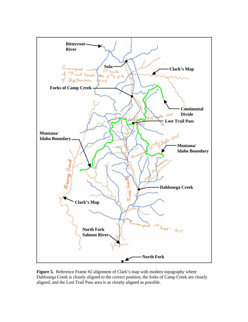
Reference Frame #2, (Figure 5) for the modified Clark map looks similiar to Figure4 except the distance scale has been changed so that Dahlonega Creek is closelyaligned to the correct position, the forks of Camp Creek are closely aligned, and theLost Trail Pass area is as closely aligned as possible. Notice now that Clark*sprotrayal of the Sula area is much too far south.
It is clear from Figures 4 and 5 that global scaling and rotation cannot correct forall the errors in the Clark map. However, the scaled distance between referencepoints #1 and #2 is reasonably close to being the same for both maps. What isneeded is a computer data analysis technique that will permit scaling and rotationover a small group of courses and distances. Such a method, using map templatesand a spreadsheet program, is described in the next section. Initially, it appearsthat Figure 5 provides the best alignment of the modern topography to the mapdrawn by Clark and is selected as the starting point for the spreadsheet analysis.
Ordering of Geographic Clues - Reason and TechnologyOrdering of Geographic Clues - Reason and TechnologyOrdering of Geographic Clues - Reason and TechnologyOrdering of Geographic Clues - Reason and Technology
The way this approach is carried out is much like a mathematical proof. Each step
Lewis and Clark over Lost Trail Pass ÕÕÕÕ Applying the Tools of Reason and Technology ÕÕÕÕ 4
Copyright 1998 Steve F. Russell
is carefully analyzed and the evidence presented in a series of maps like the seriesof steps in the proof. The goal is to lead the reader through the details of the logicused to arrive at the conclusions and not merely to present the conclusions withoutdetailed proof.
All of the data and comments in the journals were studied and summarized into aseries of geographic clues such a mention of streams and mountains. These werethen put into geographic order using journal distances and spreadsheet analysis. The ordering process was iterated until the arriving at the order which best fits allthe data and known modern topography. The route was then divided into segmentsfor this process. The first step in the analysis was to determine approximatecorrections for magnetic declination and distance scaling for the courses anddistances from the table starting on page 184 of Vol. 5 (Moulton).
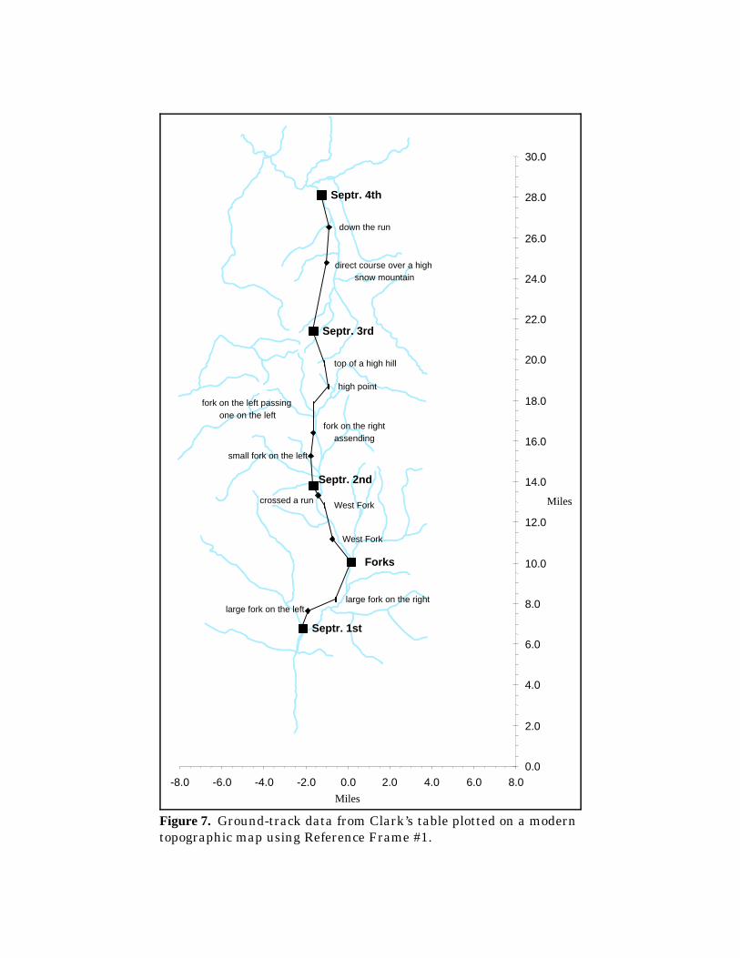
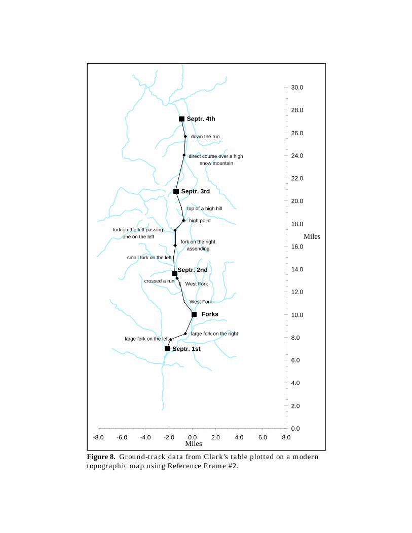
Next, a "ground track" plot for these corrected courses and distances wassuperimposed on the modified Clark map as shown in Figure 6. This overlay showsthat Clark*s table data and map are in general agreement but that there are somedisagreements that make determining their exact route and camping placesdifficult. The ground-track data from Clark*s table was also plotted on a moderntopographic map using Reference Frame #1 (Figure 7) and Reference Frame #2(Figure 8). Several points in the two reference frames are in close enoughagreement that the reference points given in Table I could be easily identified.
Table I. Easily Identified Reference Points Table I. Easily Identified Reference Points Table I. Easily Identified Reference Points Table I. Easily Identified Reference Points
Journal CitationJournal CitationJournal CitationJournal Citation Modern Geographic NameModern Geographic NameModern Geographic NameModern Geographic NameEncamped on the bottom... at a
Bluff Point mouth of Hull Creek near Bill's
Canyonto a large fork which falls in on
the left in a pine bottom Hughes Creek
to a large fork which falls in onthe right
Sheep Creek
to the forks of the Creek mouth of Dahlonega Creeka fork on the right ascending Pierce Creek
a fork on the left, passing one onthe left
West Fork of the North Fork of theSalmon near the mouth of Moose
Creekdividing ridge The Montana-Idaho border west of
Lost Trail Passto the river... a fork on the right between camp creek and Edwards
road about 0.3 miles southeast of theEast Fork of the Bitterroot river
Lewis and Clark over Lost Trail Pass ÕÕÕÕ Applying the Tools of Reason and Technology ÕÕÕÕ 5
Copyright 1998 Steve F. Russell
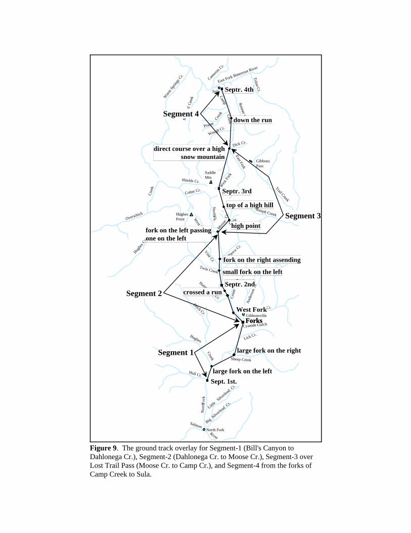
After conducting several "what-if" scenarios with the spreadsheet, it was apparentthat the route could be analyzed in the following four segments:
Segment-1Segment-1Segment-1Segment-1, Bill's Canyon to Dahlonega Creek, Bill's Canyon to Dahlonega Creek, Bill's Canyon to Dahlonega Creek, Bill's Canyon to Dahlonega CreekSegment-2Segment-2Segment-2Segment-2, Dahlonega Creek to Moose Creek, Dahlonega Creek to Moose Creek, Dahlonega Creek to Moose Creek, Dahlonega Creek to Moose CreekSegment-3Segment-3Segment-3Segment-3, Over Lost Trail Pass, Over Lost Trail Pass, Over Lost Trail Pass, Over Lost Trail PassSegment-4Segment-4Segment-4Segment-4, Forks of Camp Creek to Sula, Forks of Camp Creek to Sula, Forks of Camp Creek to Sula, Forks of Camp Creek to Sula
Segment-1Segment-1Segment-1Segment-1
The ground track overlay for Segment-1 is shown in Figure 9. The scaled androtated journal data fits the topographic data extremely well. Journal topographicreference points were assigned to Bill's Canyon (Ref #1), Hughes Creek (Ref #2.),Sheep Creek (Ref #3), and Dahlonega Creek (Ref #4).
Segment-2Segment-2Segment-2Segment-2
The ground track overlay for Segment-2 is shown in Figure 9. The followingreference points were assigned: Vineyard Gulch (Ref #5), Crone Gulch (Ref #6),Quartz Creek (Ref #7), Deep Creek (Ref #8), Twin Creek (Ref #9), Pierce Creek (Ref#10), and Moose Creek (Ref #12). There is no definite geographic name to assign toRef #11 however Clark made reference to “several spring runs on the right, stonyhills and falling timber” in his table. The scaled and rotated journal data inSegment-2 fits the topographic data quite well except for the distance betweenreference points #10 and #12. To make the plot shown in the figure, it wasnecessary to add 2 miles to the journal distance between #10 and #12, making thenew distance, 4.5 miles instead of 2.5 miles. This discrepancy is unexplainable.
Segment-3Segment-3Segment-3Segment-3
The ground track overlay for Segment-3 is shown in Figure 9. The scaled androtated journal data does not fit the topographic data very well, especially for thecamp of September 3rd. More analysis will be needed to determine a better estimatethan simple scaling and rotation.
We now will analyze Segment-3, "Over Lost Trail Pass", in more detail. Thisanalysis started with a detailed, ordered listing of the geographic references givenin the journals of Clark, Gass, Whitehouse, and Ordway. Some references fromSegment-3 are used to describe the entire day*s data. These references are listed inTable II.
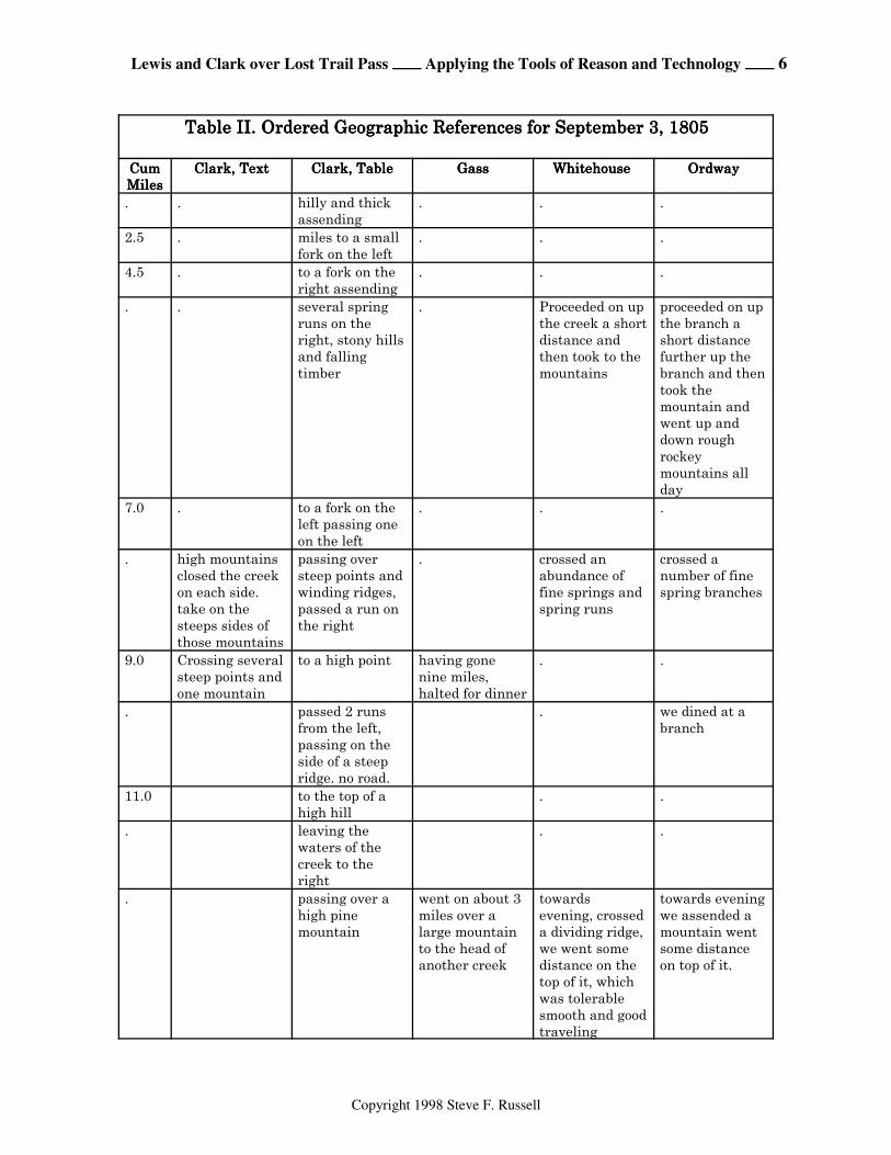
Lewis and Clark over Lost Trail Pass ÕÕÕÕ Applying the Tools of Reason and Technology ÕÕÕÕ 6
Copyright 1998 Steve F. Russell
Table II. Ordered Geographic References for September 3, 1805Table II. Ordered Geographic References for September 3, 1805Table II. Ordered Geographic References for September 3, 1805Table II. Ordered Geographic References for September 3, 1805 CumCumCumCumMilesMilesMilesMiles
Clark, TextClark, TextClark, TextClark, Text Clark, TableClark, TableClark, TableClark, Table GassGassGassGass Whitehouse Whitehouse Whitehouse Whitehouse OrdwayOrdwayOrdwayOrdway
. . hilly and thickassending
. . .
2.5 . miles to a smallfork on the left
. . .
4.5 . to a fork on theright assending
. . .
. . several springruns on theright, stony hillsand fallingtimber
. Proceeded on upthe creek a shortdistance andthen took to themountains
proceeded on upthe branch ashort distancefurther up thebranch and thentook themountain andwent up anddown roughrockeymountains allday
7.0 . to a fork on theleft passing oneon the left
. . .
. high mountainsclosed the creekon each side.take on thesteeps sides ofthose mountains
passing oversteep points andwinding ridges,passed a run onthe right
. crossed anabundance offine springs andspring runs
crossed anumber of finespring branches
9.0 Crossing severalsteep points andone mountain
to a high point having gonenine miles,halted for dinner
. .
. passed 2 runsfrom the left,passing on theside of a steepridge. no road.
. we dined at abranch
11.0 to the top of ahigh hill
. .
. leaving thewaters of thecreek to theright
. .
. passing over ahigh pinemountain
went on about 3miles over alarge mountainto the head ofanother creek
towardsevening, crosseda dividing ridge,we went somedistance on thetop of it, whichwas tolerablesmooth and goodtraveling
towards eveningwe assended amountain wentsome distanceon top of it.
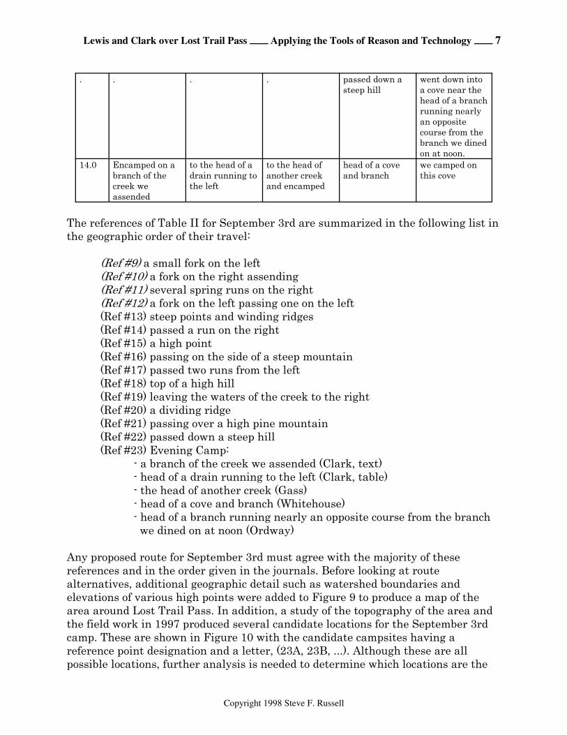
Lewis and Clark over Lost Trail Pass ÕÕÕÕ Applying the Tools of Reason and Technology ÕÕÕÕ 7
Copyright 1998 Steve F. Russell
. . . . passed down asteep hill
went down intoa cove near thehead of a branchrunning nearlyan oppositecourse from thebranch we dinedon at noon.
14.0 Encamped on abranch of thecreek weassended
to the head of adrain running tothe left
to the head ofanother creekand encamped
head of a coveand branch
we camped onthis cove
The references of Table II for September 3rd are summarized in the following list inthe geographic order of their travel:
(Ref #9) a small fork on the left(Ref #10) a fork on the right assending(Ref #11) several spring runs on the right(Ref #12) a fork on the left passing one on the left(Ref #13) steep points and winding ridges(Ref #14) passed a run on the right(Ref #15) a high point(Ref #16) passing on the side of a steep mountain(Ref #17) passed two runs from the left(Ref #18) top of a high hill(Ref #19) leaving the waters of the creek to the right(Ref #20) a dividing ridge(Ref #21) passing over a high pine mountain(Ref #22) passed down a steep hill(Ref #23) Evening Camp:
- a branch of the creek we assended (Clark, text)- head of a drain running to the left (Clark, table)- the head of another creek (Gass)- head of a cove and branch (Whitehouse)- head of a branch running nearly an opposite course from the branch we dined on at noon (Ordway)
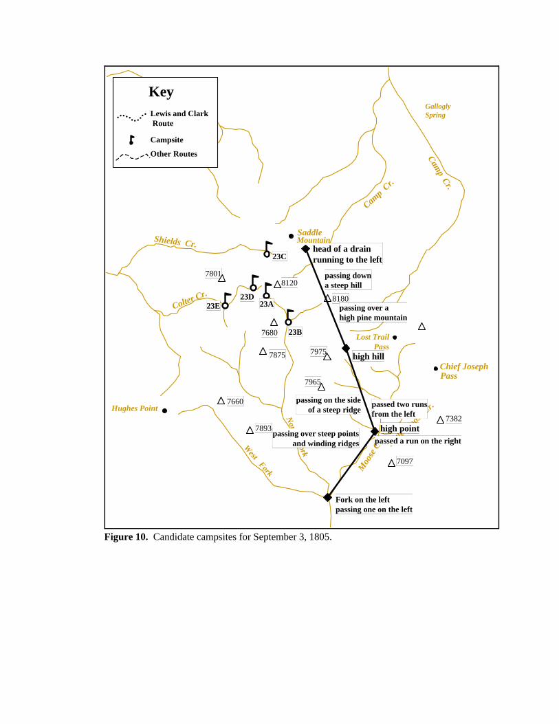
Any proposed route for September 3rd must agree with the majority of thesereferences and in the order given in the journals. Before looking at routealternatives, additional geographic detail such as watershed boundaries andelevations of various high points were added to Figure 9 to produce a map of thearea around Lost Trail Pass. In addition, a study of the topography of the area andthe field work in 1997 produced several candidate locations for the September 3rdcamp. These are shown in Figure 10 with the candidate campsites having areference point designation and a letter, (23A, 23B, ...). Although these are allpossible locations, further analysis is needed to determine which locations are the

Lewis and Clark over Lost Trail Pass ÕÕÕÕ Applying the Tools of Reason and Technology ÕÕÕÕ 8
Copyright 1998 Steve F. Russell
most probable. We should also take into account that the weather was bad, withrain and sleet, and it is very likely that the party could not see out over themountains very far to get good bearings. It may be that in the latter part of the day,their visibility was very poor when they had to seek a campsite.
Figure 10 also shows the map overlaid with the Clark's journal table data. The highpoint could be the prominent point (N 45d 40.32m; W 113d 56.97m) that Highway93 winds around just after passing the mouth of Little Moose Creek. The high hillcould be on the divide where the top of the ski tow is now located (N45d 41.41m;W113d 57.58m). The location of the camp given by the journal courses anddistances is closest to point 23C shown in Figure 10 which is at the head of ShieldsCreek.
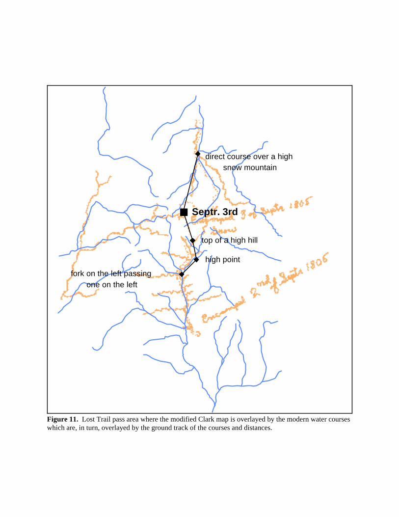
Another way of looking at the data is illustrated by Figure 11 which shows themodified Clark map overlaid by the water courses and then overlaid by the groundtrack of the courses and distances. This map shows clearly their route up MooseCreek and then northward to the divide near the “Ski Tow” west of Lost Trail Pass.The camp location on the modified Clark map is considerably too far east on thisscale but it looks like Clark intended to show the camp at the head of Colter Cr., abranch of Overwhich Cr. on the Montana side. If we were to interpret the courseand distance literally, the camp would be at the head of Camp Cr. which we know isimpractical. It appears a better approach is to closely analyze the geographicreferences and the courses and distances as compared to a modern topographic map.
We now need further study of the question, "does this route up to the high hill fitthe ordered geographic references?" and then see if the ground track of Figure 10fits the descriptions. Consulting the USGS 7.5 minute topographic map for the area(Lost Trail Pass, MT-ID) (as will be partially shown later in Figure 12), and startingnorthward at the mouth of Moose Creek, we can observe the following:
1. There are steep points and winding ridges (Ref #13) that the party is crossing2. The run on the right (Ref #14) is Little Moose Creek3. The high point (Ref #15) was discussed above4. They were passing on the side of a steep mountain (Ref #16) after theypassed the mouth of Little Moose Creek5. They passed two runs from the left (Ref #17), the first just across from LittleMoose Cr. and the second about 0.5 miles above the mouth of Little Moose Cr.6. The top of a high hill (Ref #18) is the top of the ski tow (elevation 7740) westof Lost Trail Pass.7. They had left the waters of the creek to the right (Ref #19) which agrees withthe topography for them to go up the major ridge to the northwest about 0.6 milesabove the mouth of Little Moose Cr.8. They came to a dividing ridge (Ref #20) when they reached the area of the skitow.
Lewis and Clark over Lost Trail Pass ÕÕÕÕ Applying the Tools of Reason and Technology ÕÕÕÕ 9
Copyright 1998 Steve F. Russell
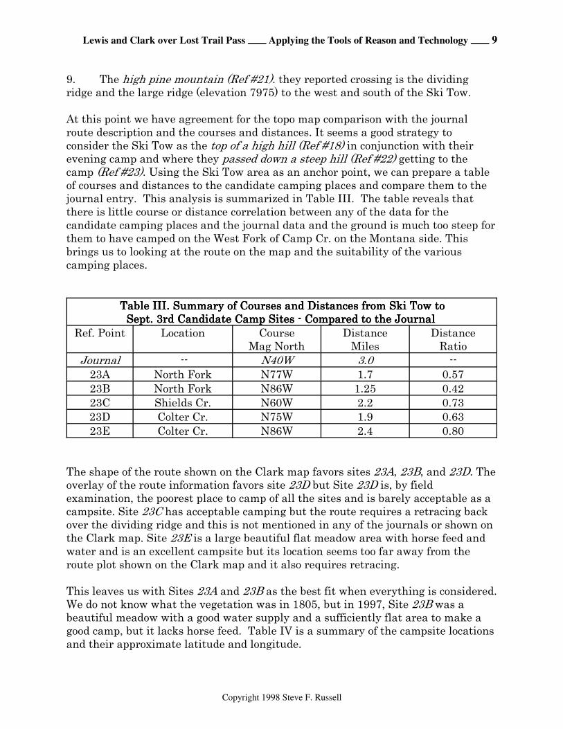
9. The high pine mountain (Ref #21). they reported crossing is the dividingridge and the large ridge (elevation 7975) to the west and south of the Ski Tow.
At this point we have agreement for the topo map comparison with the journalroute description and the courses and distances. It seems a good strategy toconsider the Ski Tow as the top of a high hill (Ref #18) in conjunction with theirevening camp and where they passed down a steep hill (Ref #22) getting to thecamp (Ref #23). Using the Ski Tow area as an anchor point, we can prepare a tableof courses and distances to the candidate camping places and compare them to thejournal entry. This analysis is summarized in Table III. The table reveals thatthere is little course or distance correlation between any of the data for thecandidate camping places and the journal data and the ground is much too steep forthem to have camped on the West Fork of Camp Cr. on the Montana side. Thisbrings us to looking at the route on the map and the suitability of the variouscamping places.
Table III. Summary of Courses and Distances from Ski Tow toTable III. Summary of Courses and Distances from Ski Tow toTable III. Summary of Courses and Distances from Ski Tow toTable III. Summary of Courses and Distances from Ski Tow toSept. 3rd Candidate Camp Sites - Compared to the JournalSept. 3rd Candidate Camp Sites - Compared to the JournalSept. 3rd Candidate Camp Sites - Compared to the JournalSept. 3rd Candidate Camp Sites - Compared to the Journal
Ref. Point Location CourseMag North
DistanceMiles
DistanceRatio
Journal -- N40W 3.0 --23A North Fork N77W 1.7 0.5723B North Fork N86W 1.25 0.4223C Shields Cr. N60W 2.2 0.7323D Colter Cr. N75W 1.9 0.6323E Colter Cr. N86W 2.4 0.80
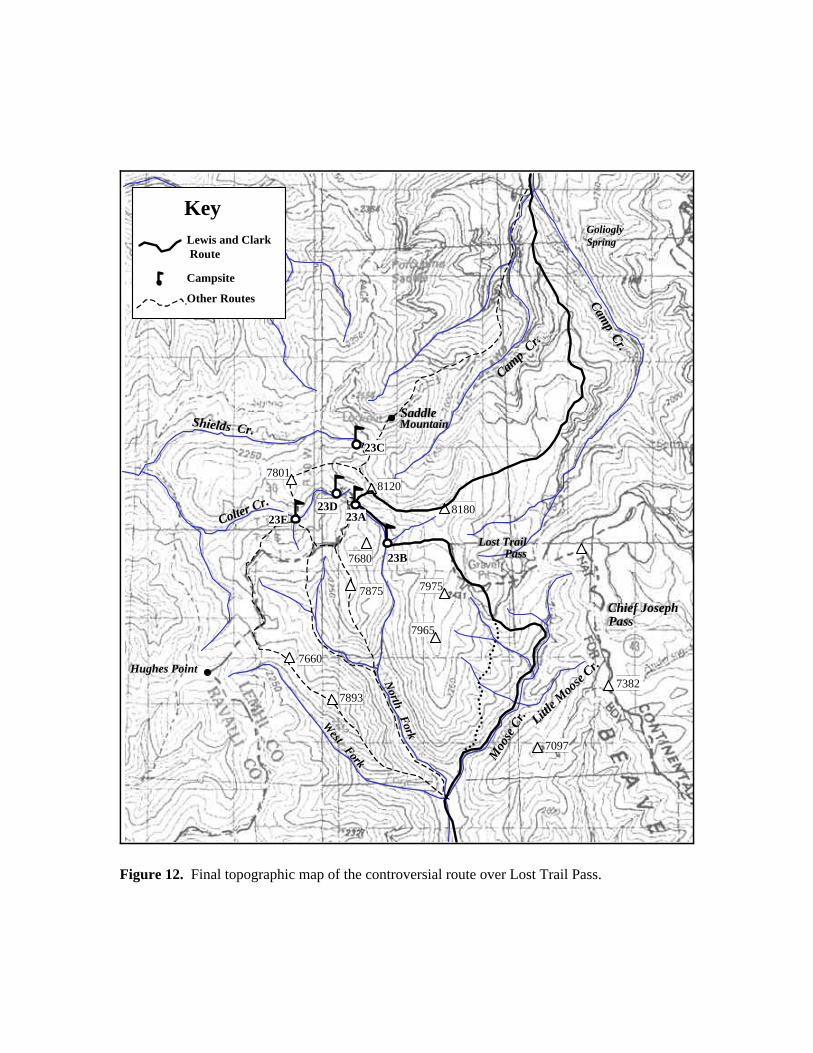
The shape of the route shown on the Clark map favors sites 23A, 23B, and 23D. Theoverlay of the route information favors site 23D but Site 23D is, by fieldexamination, the poorest place to camp of all the sites and is barely acceptable as acampsite. Site 23C has acceptable camping but the route requires a retracing backover the dividing ridge and this is not mentioned in any of the journals or shown onthe Clark map. Site 23E is a large beautiful flat meadow area with horse feed andwater and is an excellent campsite but its location seems too far away from theroute plot shown on the Clark map and it also requires retracing.
This leaves us with Sites 23A and 23B as the best fit when everything is considered.We do not know what the vegetation was in 1805, but in 1997, Site 23B was abeautiful meadow with a good water supply and a sufficiently flat area to make agood camp, but it lacks horse feed. Table IV is a summary of the campsite locationsand their approximate latitude and longitude.
Lewis and Clark over Lost Trail Pass ÕÕÕÕ Applying the Tools of Reason and Technology ÕÕÕÕ 10
Copyright 1998 Steve F. Russell
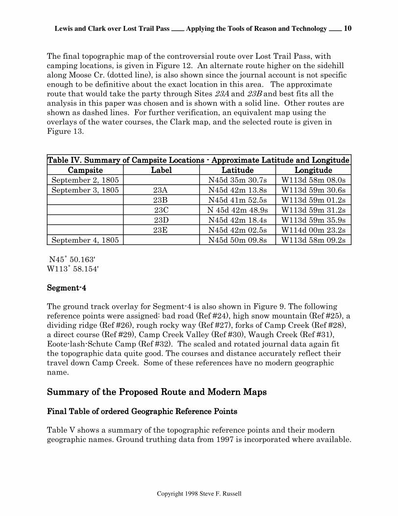
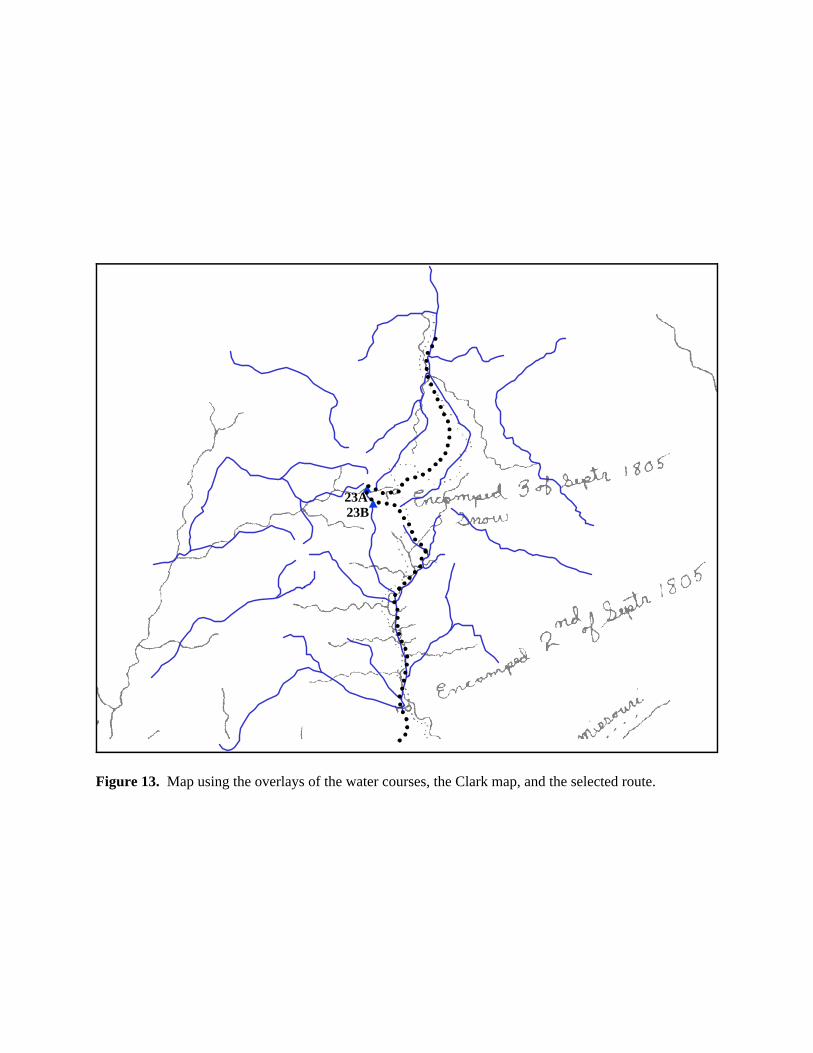
The final topographic map of the controversial route over Lost Trail Pass, withcamping locations, is given in Figure 12. An alternate route higher on the sidehillalong Moose Cr. (dotted line), is also shown since the journal account is not specificenough to be definitive about the exact location in this area. The approximateroute that would take the party through Sites 23A and 23B and best fits all theanalysis in this paper was chosen and is shown with a solid line. Other routes areshown as dashed lines. For further verification, an equivalent map using theoverlays of the water courses, the Clark map, and the selected route is given inFigure 13.
Table IV. Summary of Campsite Locations - Approximate Latitude and LongitudeTable IV. Summary of Campsite Locations - Approximate Latitude and LongitudeTable IV. Summary of Campsite Locations - Approximate Latitude and LongitudeTable IV. Summary of Campsite Locations - Approximate Latitude and Longitude CampsiteCampsiteCampsiteCampsite LabelLabelLabelLabel LatitudeLatitudeLatitudeLatitude LongitudeLongitudeLongitudeLongitude
September 2, 1805 N45d 35m 30.7s W113d 58m 08.0sSeptember 3, 1805 23A N45d 42m 13.8s W113d 59m 30.6s
23B N45d 41m 52.5s W113d 59m 01.2s23C N 45d 42m 48.9s W113d 59m 31.2s23D N45d 42m 18.4s W113d 59m 35.9s23E N45d 42m 02.5s W114d 00m 23.2s
September 4, 1805 N45d 50m 09.8s W113d 58m 09.2s
N45/ 50.163'W113/ 58.154'
Segment-4Segment-4Segment-4Segment-4
The ground track overlay for Segment-4 is also shown in Figure 9. The followingreference points were assigned: bad road (Ref #24), high snow mountain (Ref #25), adividing ridge (Ref #26), rough rocky way (Ref #27), forks of Camp Creek (Ref #28),a direct course (Ref #29), Camp Creek Valley (Ref #30), Waugh Creek (Ref #31),Eoote-lash-Schute Camp (Ref #32). The scaled and rotated journal data again fitthe topographic data quite good. The courses and distance accurately reflect theirtravel down Camp Creek. Some of these references have no modern geographicname.
Summary of the Proposed Route and Modern MapsSummary of the Proposed Route and Modern MapsSummary of the Proposed Route and Modern MapsSummary of the Proposed Route and Modern Maps
Final Table of ordered Geographic Reference PointsFinal Table of ordered Geographic Reference PointsFinal Table of ordered Geographic Reference PointsFinal Table of ordered Geographic Reference Points
Table V shows a summary of the topographic reference points and their moderngeographic names. Ground truthing data from 1997 is incorporated where available.
Lewis and Clark over Lost Trail Pass ÕÕÕÕ Applying the Tools of Reason and Technology ÕÕÕÕ 11
Copyright 1998 Steve F. Russell
Final Route Description with MapsFinal Route Description with MapsFinal Route Description with MapsFinal Route Description with Maps
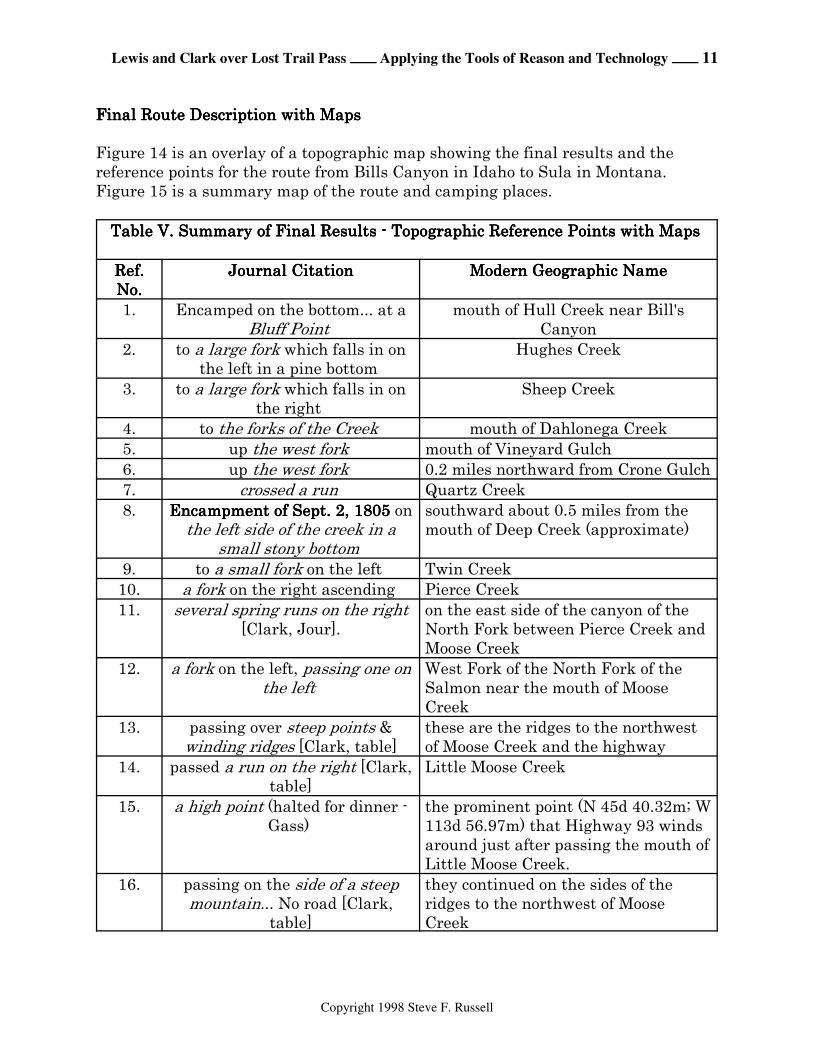
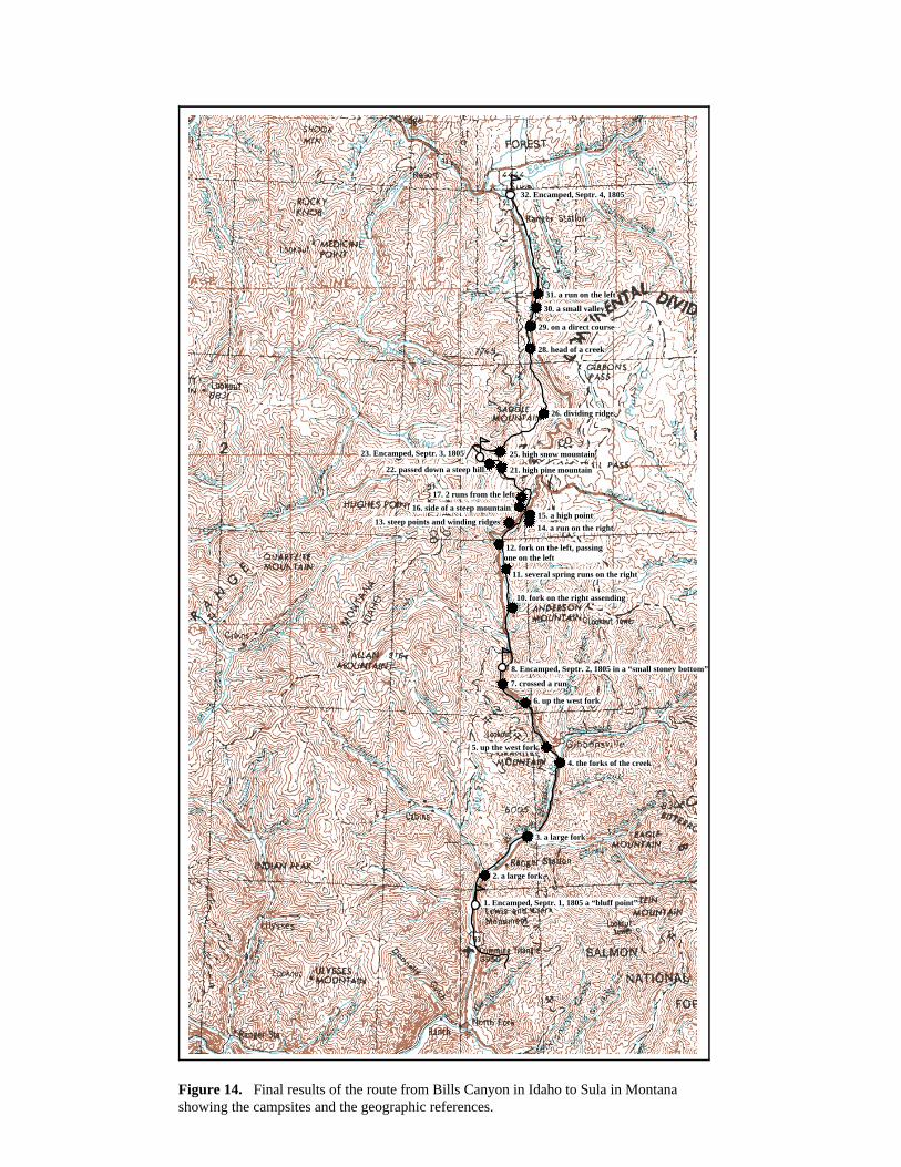
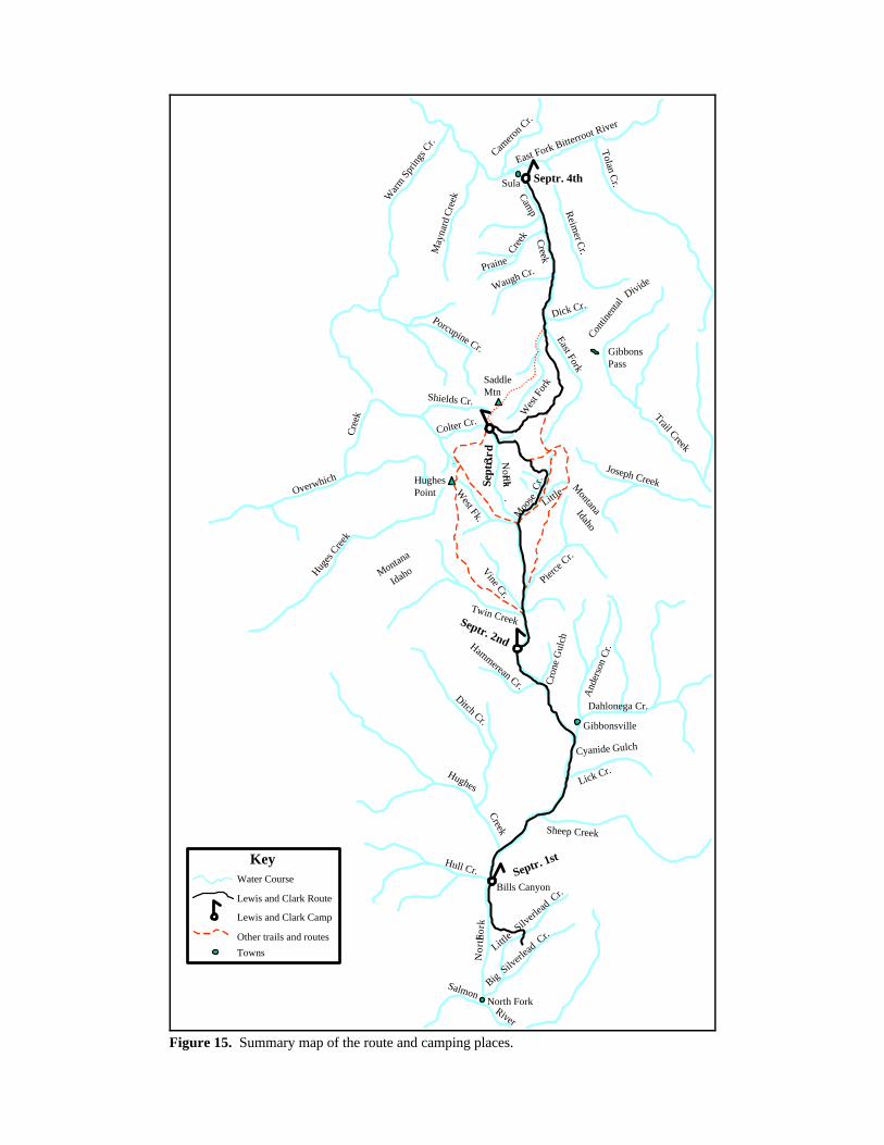
Figure 14 is an overlay of a topographic map showing the final results and thereference points for the route from Bills Canyon in Idaho to Sula in Montana. Figure 15 is a summary map of the route and camping places.
Table V. Summary of Final Results - Topographic Reference Points with Maps Table V. Summary of Final Results - Topographic Reference Points with Maps Table V. Summary of Final Results - Topographic Reference Points with Maps Table V. Summary of Final Results - Topographic Reference Points with Maps
Ref.Ref.Ref.Ref.No.No.No.No.
Journal CitationJournal CitationJournal CitationJournal Citation Modern Geographic NameModern Geographic NameModern Geographic NameModern Geographic Name
1. Encamped on the bottom... at aBluff Point
mouth of Hull Creek near Bill'sCanyon
2. to a large fork which falls in onthe left in a pine bottom
Hughes Creek
3. to a large fork which falls in onthe right
Sheep Creek
4. to the forks of the Creek mouth of Dahlonega Creek5. up the west fork mouth of Vineyard Gulch6. up the west fork 0.2 miles northward from Crone Gulch7. crossed a run Quartz Creek8. Encampment of Sept. 2, 1805Encampment of Sept. 2, 1805Encampment of Sept. 2, 1805Encampment of Sept. 2, 1805 on
the left side of the creek in asmall stony bottom
southward about 0.5 miles from themouth of Deep Creek (approximate)
9. to a small fork on the left Twin Creek10. a fork on the right ascending Pierce Creek11. several spring runs on the right
[Clark, Jour].on the east side of the canyon of theNorth Fork between Pierce Creek andMoose Creek
12. a fork on the left, passing one onthe left
West Fork of the North Fork of theSalmon near the mouth of MooseCreek
13. passing over steep points &winding ridges [Clark, table]
these are the ridges to the northwestof Moose Creek and the highway
14. passed a run on the right [Clark,table]
Little Moose Creek
15. a high point (halted for dinner -Gass)
the prominent point (N 45d 40.32m; W113d 56.97m) that Highway 93 windsaround just after passing the mouth ofLittle Moose Creek.
16. passing on the side of a steepmountain... No road [Clark,
table]
they continued on the sides of theridges to the northwest of MooseCreek
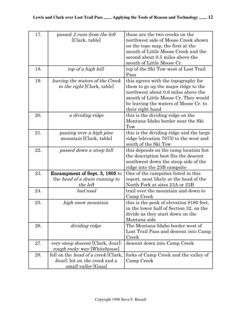
Lewis and Clark over Lost Trail Pass ÕÕÕÕ Applying the Tools of Reason and Technology ÕÕÕÕ 12
Copyright 1998 Steve F. Russell
17. passed 2 runs from the left[Clark, table]
these are the two creeks on thenorthwest side of Moose Creek shownon the topo map, the first at themouth of Little Moose Creek and thesecond about 0.5 miles above themouth of Little Moose Cr.
18. top of a high hill top of the Ski Tow west of Lost TrailPass
19. leaving the waters of the Creekto the right [Clark, table]
this agrees with the topography forthem to go up the major ridge to thenorthwest about 0.6 miles above themouth of Little Moose Cr. They wouldbe leaving the waters of Moose Cr. totheir right hand
20. a dividing ridge this is the dividing ridge on theMontana-Idaho border near the SkiTow
21. passing over a high pinemountain [Clark, table]
this is the dividing ridge and the largeridge (elevation 7975) to the west andsouth of the Ski Tow
22. passed down a steep hill this depends on the camp location butthe description best fits the descentsouthwest down the steep side of theridge into the 23B campsite
23. Encampment of Sept. 3, 1805Encampment of Sept. 3, 1805Encampment of Sept. 3, 1805Encampment of Sept. 3, 1805 tothe head of a drain running to
the left
One of the campsites listed in thisreport, most likely at the head of theNorth Fork at sites 23A or 23B
24. bad road trail over the mountain and down toCamp Creek
25. high snow mountain this is the peak of elevation 8180 feet,in the lower half of Section 32, on thedivide as they start down on theMontana side
26. dividing ridge The Montana-Idaho border west ofLost Trail Pass and descent into CampCreek
27. very steep descent [Clark, Jour];rough rocky way [Whitehouse]
descent down into Camp Creek
28. fell on the head of a creek [Clark,Jour]; hit on the creek and a
small valley [Gass]
forks of Camp Creek and the valley ofCamp Creek

Lewis and Clark over Lost Trail Pass ÕÕÕÕ Applying the Tools of Reason and Technology ÕÕÕÕ 13
Copyright 1998 Steve F. Russell
29. on a direct course over a highsnow mountain
over the divide between Montana andIdaho; endpoint approximately theforks of Camp Creek
30. a small valley Valley of Camp Creek31. a run on the left Waugh Creek32. to the river... a fork on the right between Camp Creek and Edwards
Road about 0.3 miles southeast of theEast Fork of the Bitterroot River. This was the Eoote-lash-Schute Camp
BibliographyBibliographyBibliographyBibliography
1. Moulton, Gary E., Editor, "The Journals of the Lewis & Clark Expedition",Vols. 1-11, Lincoln: University of Nebraska Press, 1983-1997.
2. Thwaites, Reuben Gold, Ed. "Original Journals of the Lewis and ClarkExpedition", 1804- 1806. 8 Volumes, New York: Dodd, Mead and Co., 1904-1905.
3. Gass, Patrick, "Journal of Lewis and Clark Expedition", Philadelphia, 1810.A. C. McClurg & Co., Chicago, 1904. Ross & Haines, Inc., Minneapolis,Minnesota, 1958.
Lewis and Clark over Lost Trail Pass ÕÕÕÕ Applying the Tools of Reason and Technology ÕÕÕÕ 14
Copyright 1998 Steve F. Russell
APPENDIXAPPENDIXAPPENDIXAPPENDIX ÕÕÕÕ From the JournalsFrom the JournalsFrom the JournalsFrom the Journals
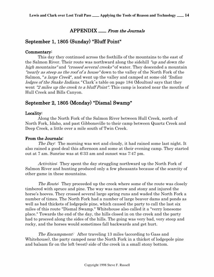
September 1, 1805 (Sunday) "Bluff Point"September 1, 1805 (Sunday) "Bluff Point"September 1, 1805 (Sunday) "Bluff Point"September 1, 1805 (Sunday) "Bluff Point"
Commentary:Commentary:Commentary:Commentary:This day they continued across the foothills of the mountains to the east of
the Salmon River. Their route was northward along the sidehill "up and down thehigh mountains" and "crossed several creeks" of water. They descended a mountain"nearly as steep as the roof of a house" down to the valley of the North Fork of theSalmon, "a large Creek", and went up the valley and camped at some old "Indianlodges of the Snake Indians." Clark*s table on page 184 (Moulton) says that theywent "2 miles up the creek to a bluff Point". This camp is located near the mouths ofHull Creek and Bills Canyon.
September 2, 1805 (Monday) "Dismal Swamp"September 2, 1805 (Monday) "Dismal Swamp"September 2, 1805 (Monday) "Dismal Swamp"September 2, 1805 (Monday) "Dismal Swamp"
Locality:Locality:Locality:Locality:Along the North Fork of the Salmon River between Hull Creek, north of
North Fork, Idaho, and past Gibbonsville to their camp between Quartz Creek andDeep Creek, a little over a mile south of Twin Creek.
From the Journals:From the Journals:From the Journals:From the Journals:The Day: The morning was wet and cloudy, it had rained some last night. It
also rained a good deal this afternoon and some at their evening camp. They startedout at 7 am. Sunrise was at 6:33 am and sunset was 7:47 pm.
Activities: They spent the day struggling northward up the North Fork ofSalmon River and hunting produced only a few pheasants because of the scarcity ofother game in these mountains.
The Route: They proceeded up the creek where some of the route was closelytimbered with spruce and pine. The way was narrow and stony and injured thehorse’s hooves. They crossed several large spring runs and waded the North Fork anumber of times. The North Fork had a number of large beaver dams and ponds aswell as bad thickets of lodgepole pine, which caused the party to call the last sixmiles of this route "Dismal Swamp." Whitehouse also called it a "verry lonesomeplace." Towards the end of the day, the hills closed in on the creek and the partyhad to proceed along the sides of the hills. The going was very bad, very steep androcky, and the horses would sometimes fall backwards and get hurt.
The Encampment: After traveling 13 miles (according to Gass andWhitehouse), the party camped near the North Fork in a thicket of lodgepole pineand balsam fir on the left (west) side of the creek in a small stony bottom.
Lewis and Clark over Lost Trail Pass ÕÕÕÕ Applying the Tools of Reason and Technology ÕÕÕÕ 15
Copyright 1998 Steve F. Russell
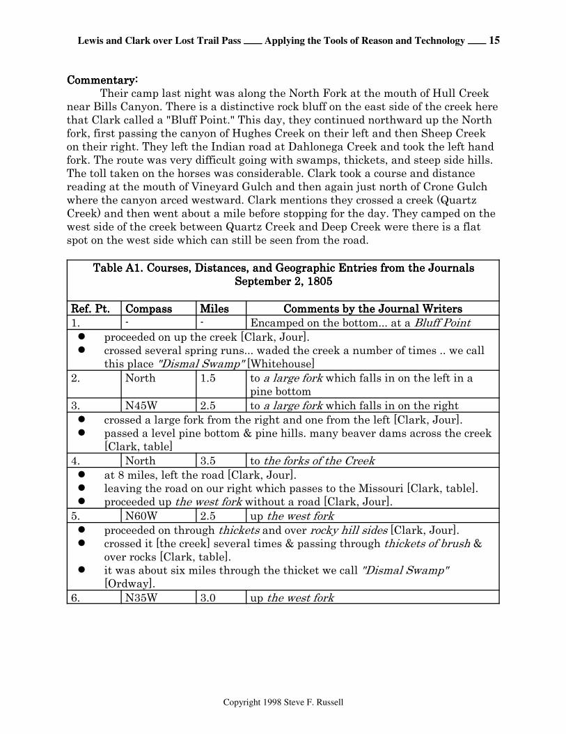
Commentary:Commentary:Commentary:Commentary:Their camp last night was along the North Fork at the mouth of Hull Creek
near Bills Canyon. There is a distinctive rock bluff on the east side of the creek herethat Clark called a "Bluff Point." This day, they continued northward up the Northfork, first passing the canyon of Hughes Creek on their left and then Sheep Creekon their right. They left the Indian road at Dahlonega Creek and took the left handfork. The route was very difficult going with swamps, thickets, and steep side hills.The toll taken on the horses was considerable. Clark took a course and distancereading at the mouth of Vineyard Gulch and then again just north of Crone Gulchwhere the canyon arced westward. Clark mentions they crossed a creek (QuartzCreek) and then went about a mile before stopping for the day. They camped on thewest side of the creek between Quartz Creek and Deep Creek were there is a flatspot on the west side which can still be seen from the road.
Table A1. Courses, Distances, and Geographic Entries from the JournalsTable A1. Courses, Distances, and Geographic Entries from the JournalsTable A1. Courses, Distances, and Geographic Entries from the JournalsTable A1. Courses, Distances, and Geographic Entries from the JournalsSeptember 2, 1805September 2, 1805September 2, 1805September 2, 1805
Ref. Pt.Ref. Pt.Ref. Pt.Ref. Pt. CompassCompassCompassCompass MilesMilesMilesMiles Comments by the Journal WritersComments by the Journal WritersComments by the Journal WritersComments by the Journal Writers1. - - Encamped on the bottom... at a Bluff Point ! proceeded on up the creek [Clark, Jour]. ! crossed several spring runs... waded the creek a number of times .. we call
this place "Dismal Swamp" [Whitehouse] 2. North 1.5 to a large fork which falls in on the left in a
pine bottom 3. N45W 2.5 to a large fork which falls in on the right ! crossed a large fork from the right and one from the left [Clark, Jour]. ! passed a level pine bottom & pine hills. many beaver dams across the creek
[Clark, table] 4. North 3.5 to the forks of the Creek ! at 8 miles, left the road [Clark, Jour]. ! leaving the road on our right which passes to the Missouri [Clark, table]. ! proceeded up the west fork without a road [Clark, Jour]. 5. N60W 2.5 up the west fork ! proceeded on through thickets and over rocky hill sides [Clark, Jour]. ! crossed it [the creek] several times & passing through thickets of brush &
over rocks [Clark, table]. ! it was about six miles through the thicket we call "Dismal Swamp"
[Ordway]. 6. N35W 3.0 up the west fork
Lewis and Clark over Lost Trail Pass ÕÕÕÕ Applying the Tools of Reason and Technology ÕÕÕÕ 16
Copyright 1998 Steve F. Russell
! over hills, rocks, & steep points & hill sides on the left of the creek [Clark,table].
! up and down steep hills [Clark, Jour]. ! in some places we were obliged to go up the side of the hills, which are very
steep, and then down again in order to get along at all [Gass]. ! crossing a run at one mile [Clark, table]. 7. N50W 1.0 crossed a run 8. N50W 1.0 Encampment of Sept. 2, 1805Encampment of Sept. 2, 1805Encampment of Sept. 2, 1805Encampment of Sept. 2, 1805 on the left side of
the creak in a small stony bottom ! we came 13 miles today and camped in a thicket of pine and balsam fir
timber near the creek... this horrid bad going where we came up this creek,which we call "Dismal Swamp," was six miles and we are not out of it yet[Whitehouse].
! we went 13 miles and encamped [Gass]. ! we went 13 miles this day and camped in a thicket near the creek [Ordway]. ! made 5 miles and encamped [Clark, Jour]. ! no game of any kind to be seen in these mountains [Ordway].
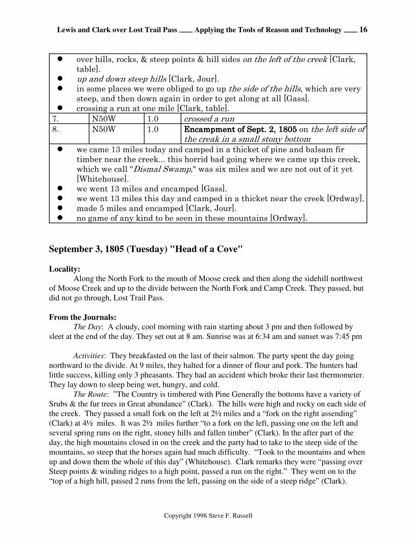
September 3, 1805 (Tuesday) "Head of a Cove"
Locality:
Along the North Fork to the mouth of Moose creek and then along the sidehill northwest
of Moose Creek and up to the divide between the North Fork and Camp Creek. They passed, but
did not go through, Lost Trail Pass.
From the Journals:
The Day: A cloudy, cool morning with rain starting about 3 pm and then followed by
sleet at the end of the day. They set out at 8 am. Sunrise was at 6:34 am and sunset was 7:45 pm
Activities: They breakfasted on the last of their salmon. The party spent the day going
northward to the divide. At 9 miles, they halted for a dinner of flour and pork. The hunters had
little success, killing only 3 pheasants. They had an accident which broke their last thermometer.
They lay down to sleep being wet, hungry, and cold.
The Route: ”The Country is timbered with Pine Generally the bottoms have a variety of
Srubs & the fur trees in Great abundance” (Clark). The hills were high and rocky on each side of
the creek. They passed a small fork on the left at 2½ miles and a “fork on the right assending”
(Clark) at 4½ miles. It was 2½ miles further “to a fork on the left, passing one on the left and
several spring runs on the right, stoney hills and fallen timber” (Clark). In the after part of the
day, the high mountains closed in on the creek and the party had to take to the steep side of the
mountains, so steep that the horses again had much difficulty. “Took to the mountains and when
up and down them the whole of this day” (Whitehouse). Clark remarks they were “passing over
Steep points & winding ridges to a high point, passed a run on the right.” They went on to the
“top of a high hill, passed 2 runs from the left, passing on the side of a steep ridge” (Clark).
Lewis and Clark over Lost Trail Pass ÕÕÕÕ Applying the Tools of Reason and Technology ÕÕÕÕ 17
Copyright 1998 Steve F. Russell
Ordway says “we dined at a branch.” After dinner, Gass reports “We then went on about 3 miles
over a large mountain, to the head of another creek and encamped there for the night.” “Towards
evening, we crossed a dividing ridge, we went some distance on top of it which was tolerable
smooth & good traveling, We then passed down a steep hill, at the head of a cove and branch”
(Whitehouse). From the top of a high hill, Clark says they went 3 miles “leaving the waters of
the creek to the right & passing over a high pine Mountn. to the head of a Drean running to the
left.”
The Route: The country was timbered with pine, fur, and shrubs. The hills were high and
rocky on each side of the creek. Passed a small fork on the left. Passed a fork on the right
ascending. To a fork on the left, passing one on the left and several spring runs on the right,
stoney hills and fallen timber. In the after part of the day, the high mountains closed in on the
creek and the party had to take to the steep side of the mountains, so steep that the horses again
had much difficulty. Took to the mountains and when up and down them the whole day. Passed
over steep points and winding ridges to a high point, passed a run on the right. Proceeded on to
the top of a high hill, passed 2 runs from the left, passing on the side of a steep ridge. Passed over
emense hills, crossed several steep points and one mountain. Dined at a branch. Towards
evening, we crossed a dividing ridge, we went some distance on top of it which was tolerable
smooth and odd traveling. We then passed down a steep hill, at the head of a cove and branch.
After dinner, went on about 3 miles over a large mountain to the head of another creek. Left the
waters of the creek to the right and passed over a high pine mountain to the head of a drain
running to the left.
The Encampment: "Encamped on a branch of the creek we assended" (Clark, text).
Encamped at "the head of a drean running to the left" (Clark, table). "Went on... to the head of
another creek and encamped..." (Gass). "at the head of a cove and branch" (Whitehouse). Went
down into a cove near the head of a branch running in nearly the opposite course from the branch
we dined on at noon (Ordway).
Commentary:
They continued to travel along the North Fork past the canyon of Deep Creek and crossed
Twin Creek and Vine Creek. They passed to the west of the mouth of Pierce Creek and then
crossed the North Fork and followed up its east side to the mouth of Moose Creek. The route
after this is confusing due to the general comments by the journal writers and the many
topographic possibilities. Only after considerable study of the journals and Clark's Map is it
possible to make a good estimate of the route. From the mouth of Moose Cr., they continued
northeast up Moose Cr. but it is unclear as to which side or how far up on the sidehill out of the
creek bottom. Once they passed the mouth of Little Moose Cr., they turned northward and
reached the divide at the small knob where the Ski Tow is shown on the topo map. They then
proceeded westward along the divide until they dropped down into the head of the North Fork
where they camped.
Lewis and Clark over Lost Trail Pass ÕÕÕÕ Applying the Tools of Reason and Technology ÕÕÕÕ 18
Copyright 1998 Steve F. Russell
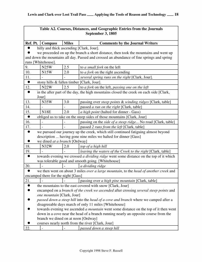
Table A2. Courses, Distances, and Geographic Entries from the Journals
September 3, 1805
Ref. Pt. Compass Miles Comments by the Journal Writers
! hilly and thick ascending [Clark, Jour].
! we proceeded on up the branch a short distance, then took the mountains and went up
and down the mountains all day. Passed and crossed an abundance of fine springs and spring
runs [Whitehouse].
9. N25W 2.5 to a small fork on the left
10. N15W 2.0 to a fork on the right ascending
11. - - several spring runs on the right [Clark, Jour].
! stony hills & fallen timber [Clark, Jour].
12. N22W 2.5 to a fork on the left, passing one on the left
! in the after part of the day, the high mountains closed the creek on each side [Clark,
Jour]
13. N35W 3.0 passing over steep points & winding ridges [Clark, table]
14. - - passed a run on the right [Clark, table]
15. N18E 2.0 a high point (halted for dinner - Gass)
! obliged us to take on the steep sides of those mountains [Clark, Jour]
16. - - passing on the side of a steep ridge... No road [Clark, table]
17. - - passed 2 runs from the left [Clark, table]
! we pursued our journey up the creek, which still continued fatiguing almost beyond
description ... having gone nine miles we halted for dinner [Gass]
! we dined at a branch [Ordway]
18. N32W 2.0 top of a high hill
19. - - leaving the waters of the Creek to the right [Clark, table]
! towards evening we crossed a dividing ridge went some distance on the top of it which
was tolerable good and smooth going. [Whitehouse]
20. - - a dividing ridge
! we then went on about 3 miles over a large mountain, to the head of another creek and
encamped there for the night [Gass]
21. - - passing over a high pine mountain [Clark, table]
! the mountains to the east covered with snow [Clark, Jour]
! encamped on a branch of the creek we ascended after crossing several steep points and
one mountain [Clark, Jour]
! passed down a steep hill into the head of a cove and branch where we camped after a
disagreeable days march of only 11 miles [Whitehouse]
! towards evening we ascended a mountain went some distance on the top of it then went
down in a cove near the head of a branch running nearly an opposite course from the
branch we dined on at noon [Ordway]
! courses nearly north from the river [Clark, Jour]
22. - - passed down a steep hill
Lewis and Clark over Lost Trail Pass ÕÕÕÕ Applying the Tools of Reason and Technology ÕÕÕÕ 19
Copyright 1998 Steve F. Russell
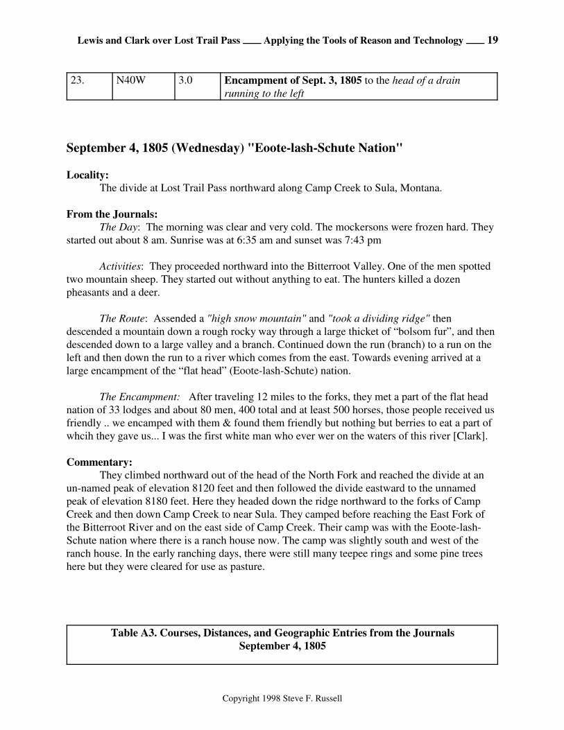
23. N40W 3.0 Encampment of Sept. 3, 1805 to the head of a drain
running to the left
September 4, 1805 (Wednesday) "Eoote-lash-Schute Nation"
Locality:
The divide at Lost Trail Pass northward along Camp Creek to Sula, Montana.
From the Journals:
The Day: The morning was clear and very cold. The mockersons were frozen hard. They
started out about 8 am. Sunrise was at 6:35 am and sunset was 7:43 pm
Activities: They proceeded northward into the Bitterroot Valley. One of the men spotted
two mountain sheep. They started out without anything to eat. The hunters killed a dozen
pheasants and a deer.
The Route: Assended a "high snow mountain" and "took a dividing ridge" then
descended a mountain down a rough rocky way through a large thicket of “bolsom fur”, and then
descended down to a large valley and a branch. Continued down the run (branch) to a run on the
left and then down the run to a river which comes from the east. Towards evening arrived at a
large encampment of the “flat head” (Eoote-lash-Schute) nation.
The Encampment: After traveling 12 miles to the forks, they met a part of the flat head
nation of 33 lodges and about 80 men, 400 total and at least 500 horses, those people received us
friendly .. we encamped with them & found them friendly but nothing but berries to eat a part of
whcih they gave us... I was the first white man who ever wer on the waters of this river [Clark].
Commentary:
They climbed northward out of the head of the North Fork and reached the divide at an
un-named peak of elevation 8120 feet and then followed the divide eastward to the unnamed
peak of elevation 8180 feet. Here they headed down the ridge northward to the forks of Camp
Creek and then down Camp Creek to near Sula. They camped before reaching the East Fork of
the Bitterroot River and on the east side of Camp Creek. Their camp was with the Eoote-lash-
Schute nation where there is a ranch house now. The camp was slightly south and west of the
ranch house. In the early ranching days, there were still many teepee rings and some pine trees
here but they were cleared for use as pasture.
Table A3. Courses, Distances, and Geographic Entries from the Journals
September 4, 1805
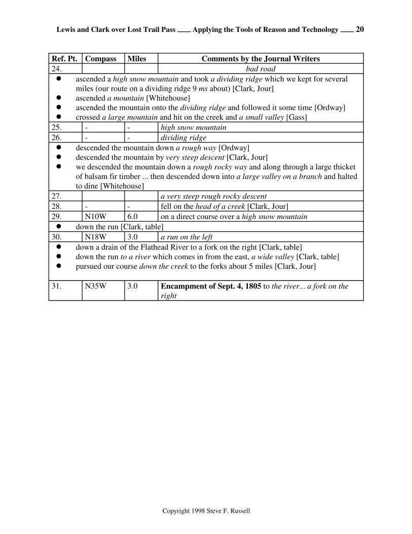
Lewis and Clark over Lost Trail Pass ÕÕÕÕ Applying the Tools of Reason and Technology ÕÕÕÕ 20
Copyright 1998 Steve F. Russell
Ref. Pt. Compass Miles Comments by the Journal Writers
24. bad road
! ascended a high snow mountain and took a dividing ridge which we kept for several
miles (our route on a dividing ridge 9 ms about) [Clark, Jour]
! ascended a mountain [Whitehouse]
! ascended the mountain onto the dividing ridge and followed it some time [Ordway]
! crossed a large mountain and hit on the creek and a small valley [Gass]
25. - - high snow mountain
26. - - dividing ridge
! descended the mountain down a rough way [Ordway]
! descended the mountain by very steep descent [Clark, Jour]
! we descended the mountain down a rough rocky way and along through a large thicket
of balsam fir timber ... then descended down into a large valley on a branch and halted
to dine [Whitehouse]
27. a very steep rough rocky descent
28. - - fell on the head of a creek [Clark, Jour]
29. N10W 6.0 on a direct course over a high snow mountain
! down the run [Clark, table]
30. N18W 3.0 a run on the left
! down a drain of the Flathead River to a fork on the right [Clark, table]
! down the run to a river which comes in from the east, a wide valley [Clark, table]
! pursued our course down the creek to the forks about 5 miles [Clark, Jour]
31. N35W 3.0 Encampment of Sept. 4, 1805 to the river... a fork on the
right
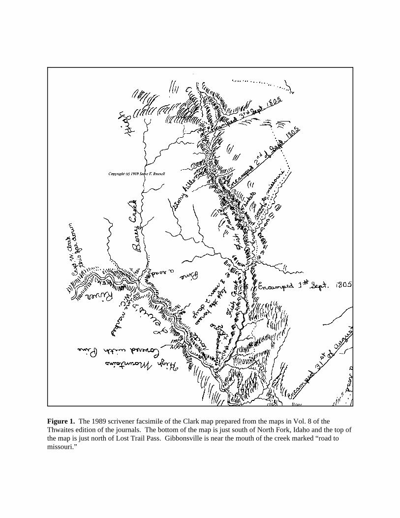
Figure 1. The 1989 scrivener facsimile of the Clark map prepared from the maps in Vol. 8 of theThwaites edition of the journals. The bottom of the map is just south of North Fork, Idaho and the top ofthe map is just north of Lost Trail Pass. Gibbonsville is near the mouth of the creek marked “road tomissouri.”
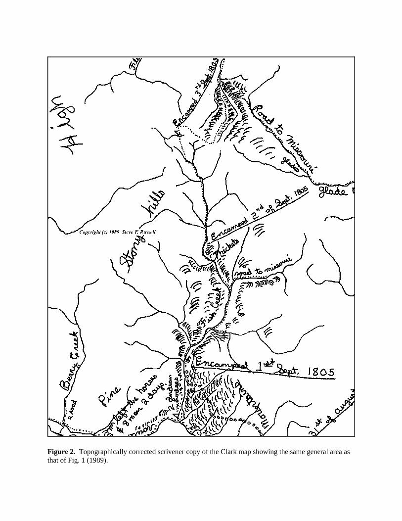
Figure 2. Topographically corrected scrivener copy of the Clark map showing the same general area asthat of Fig. 1 (1989).
North Fork
Gibbonsville
Sula(Anchor Pt. #3)
Dahlonega Creek
North Fork Salmon River
Hughes Cr.
Camp Creek
BitterrootRiver
Lost Trail Pass(Anchor Pt. #2)
Indian Creek
(Anchor Pt. #1)
Figure 3. Anchor points and modern topographic references that are easily identified on Clark’smap.
Sula
North Fork
ContinentalDivide
Montana/Idaho Boundary
Montana/Idaho Boundary
North ForkSalmon River
BitterrootRiver
Dahlonega Creek
Forks of Camp Creek
Lost Trail Pass
Clark’s Map
Clark’s Map
Figure 4. Reference Frame #1 alignment of Clark’s Map with modern topographyusing Sula and the mouth of Dahlonega Creek (near Gibbonsville) as anchor points.
Sula
North Fork
ContinentalDivide
Montana/Idaho Boundary
Montana/Idaho Boundary
North ForkSalmon River
BitterrootRiver
Dahlonega Creek
Forks of Camp Creek
Lost Trail Pass
Clark’s Map
Clark’s Map
Figure 5. Reference Frame #2 alignment of Clark’s map with modern topography whereDahlonega Creek is closely aligned to the correct position, the forks of Camp Creek are closelyaligned, and the Lost Trail Pass area is as closely aligned as possible.

top of a high hill
Forks
down the run
Septr. 1st
Septr. 3rd
Septr. 4th
West Fork
West Fork
Septr. 2ndcrossed a run
small fork on the left
fork on the right assending
fork on the left passing one on the left
high point
large fork on the right
large fork on the left
direct course over a high snow mountain
0.0
2.0
4.0
6.0
8.0
10.0
12.0
14.0
16.0
18.0
20.0
22.0
24.0
26.0
28.0
30.0
-8.0 -6.0 -4.0 -2.0 0.0 2.0 4.0 6.0 8.0
Miles
Miles
Figure 6. Courses and distances from Clark’s table superimposed on Clark’smodified map.
2.0
4.0
6.0
8.0
10.0
12.0
14.0
16.0
18.0
20.0
22.0
24.0
26.0
28.0
30.0
0.0-8.0 -6.0 -4.0 -2.0 0.0 2.0 4.0 6.0 8.0
Miles
Miles
top of a high hill
Forks
down the run
Septr. 1st
Septr. 3rd
Septr. 4th
West Fork
West Fork
Septr. 2nd
crossed a run
small fork on the left
fork on the right assending
fork on the left passing one on the left
high point
large fork on the rightlarge fork on the left
direct course over a high snow mountain
Figure 7. Ground-track data from Clark’s table plotted on a moderntopographic map using Reference Frame #1.
-8.0 -6.0 -4.0 -2.0 0.0 2.0 4.00.0
2.0
4.0
6.0
8.0
10.0
12.0
14.0
16.0
18.0
20.0
22.0
24.0
26.0
28.0
30.0
6.0 8.0Miles
Miles
top of a high hill
Forks
down the run
Septr. 1st
Septr. 3rd
Septr. 4th
West Fork
West Fork
Septr. 2nd
crossed a run
small fork on the left
fork on the right assending
fork on the left passing one on the left
high point
large fork on the rightlarge fork on the left
direct course over a high snow mountain
Figure 8. Ground-track data from Clark’s table plotted on a moderntopographic map using Reference Frame #2.
Moo
seC
r.
Salmon
River
Big Silv
erlea
d Cr.
Nor
th For
k
Little
Silverl
ead C
r.
Hull Cr.
Sheep Creek
Hughes
Ditch Cr.
Lick Cr.
Dahlonega Cr.
Creek
North Fork
Gibbonsville
And
erso
n C
r.
Cyanide Gulch
Cro
ne G
ulchHammerean Cr.
Pierce
Cr.
Twin Creek
Vine Cr.
Little
North F
k.West Fk.
Overwhich
Cre
ek
Shields Cr.
Colter Cr.
Trail Creek
Joseph Creek
East Fork
Wes
t For
k
Porcupine Cr.
Cam
pC
reek
Dick Cr.
East Fork Bitterroot River
Sula
Reim
er Cr.
Tolan C
r.
Camero
n Cr.
Waugh Cr.Praine
Creek
May
nard
Cre
ekWar
m S
prin
gs C
r.
SaddleMtn
HughesPoint
GibbonsPass
Hughe
s Cre
ek
Sept. 1st.
Forks
large fork on the left
large fork on the right
Forks
Septr. 2nd
small fork on the left
fork on the right assending
fork on the left passingone on the left
high point
top of a high hill
Septr. 3rd
direct course over a highsnow mountain
West Fork
crossed a run
down the run
Septr. 4th
Segment 1
Segment 2
Segment 3
Segment 4
Figure 9. The ground track overlay for Segment-1 (Bill's Canyon toDahlonega Cr.), Segment-2 (Dahlonega Cr. to Moose Cr.), Segment-3 overLost Trail Pass (Moose Cr. to Camp Cr.), and Segment-4 from the forks ofCamp Creek to Sula.
Chief JosephPass
Lost TrailPass
Hughes Point
MountainSaddle
Colter Cr.
Shields Cr.
North F
ork
Moo
se C
r. Little M
oose
Cr.
Camp Cr.
GalloglySpring
Camp
Cr.
West Fork
KeyLewis and Clark Route
Other Routes
Campsite
78018120
8180
7975
7965
7893
7660
7097
7382
7875
7680
23A
23B
23C
23D23E
Fork on the leftpassing one on the left
passed a run on the rightpassing over steep points
and winding ridges
passing on the sideof a steep ridge
passed two runsfrom the left
high point
passing over a high pine mountain
passing downa steep hill
head of a drainrunning to the left
high hill
Figure 10. Candidate campsites for September 3, 1805.
top of a high hill
Septr. 3rd
fork on the left passing one on the left
high point
direct course over a high snow mountain
Figure 11. Lost Trail pass area where the modified Clark map is overlayed by the modern water courseswhich are, in turn, overlayed by the ground track of the courses and distances.
78018120
8180
7975
7965
7893
7660
7097
7382
7875
7680
Chief JosephPass
Lost TrailPass
Hughes Point
MountainSaddle
Colter Cr.
Shields Cr.N
orth Fork
Moo
se C
r. Little M
oose
Cr.
Camp Cr.
GolioglySpring
Camp
Cr.
West Fork
KeyLewis and Clark Route
Other Routes
Campsite
23A
23B
23C
23D23E
Figure 12. Final topographic map of the controversial route over Lost Trail Pass.
23B23A
Figure 13. Map using the overlays of the water courses, the Clark map, and the selected route.
8. Encamped, Septr. 2, 1805 in a “small stoney bottom”
4. the forks of the creek
3. a large fork
2. a large fork
1. Encamped, Septr. 1, 1805 a “bluff point”
7. crossed a run
6. up the west fork
5. up the west fork
23. Encamped, Septr. 3, 1805
12. fork on the left, passingone on the left
11. several spring runs on the right
10. fork on the right assending
14. a run on the right 13. steep points and winding ridges
15. a high point 16. side of a steep mountain
17. 2 runs from the left
22. passed down a steep hill 21. high pine mountain
25. high snow mountain
26. dividing ridge
28. head of a creek
29. on a direct course
30. a small valley
32. Encamped, Septr. 4, 1805
31. a run on the left
Figure 14. Final results of the route from Bills Canyon in Idaho to Sula in Montanashowing the campsites and the geographic references.
Moo
seC
r.
Salmon
River
Bills Canyon
Big Silv
erlea
d Cr.
Nor
th
For
k
Little
Silverl
ead C
r.
Hull Cr.
Sheep Creek
Hughes
Ditch Cr.
Lick Cr.
Dahlonega Cr.
Creek
North Fork
Gibbonsville
And
erso
n C
r.
Cyanide Gulch
Cro
ne G
ulchHammerean Cr.
Montana
Idaho
MontanaIdaho
Pierce
Cr.
Twin Creek
Vine Cr.
Contin
ental
Divide
Little
North
Fk
.
West Fk.
Overwhich
Cre
ek
Shields Cr.
Colter Cr.
Trail Creek
Joseph Creek
East Fork
Wes
t For
k
Porcupine Cr.
Cam
pC
reek
Dick Cr.
East Fork Bitterroot River
Sula
Reim
er Cr.
Tolan C
r.
Camero
n Cr.
Waugh Cr.Praine
Creek
May
nard
Cre
ekWar
m S
prin
gs C
r.
SaddleMtn
HughesPoint
GibbonsPass
KeyWater Course
Lewis and Clark Route
Other trails and routes
Lewis and Clark Camp
Towns
Huges
Cre
ek
Septr. 2nd
Septr. 4th
Sept
r .
3rd
Septr. 1st
Figure 15. Summary map of the route and camping places.
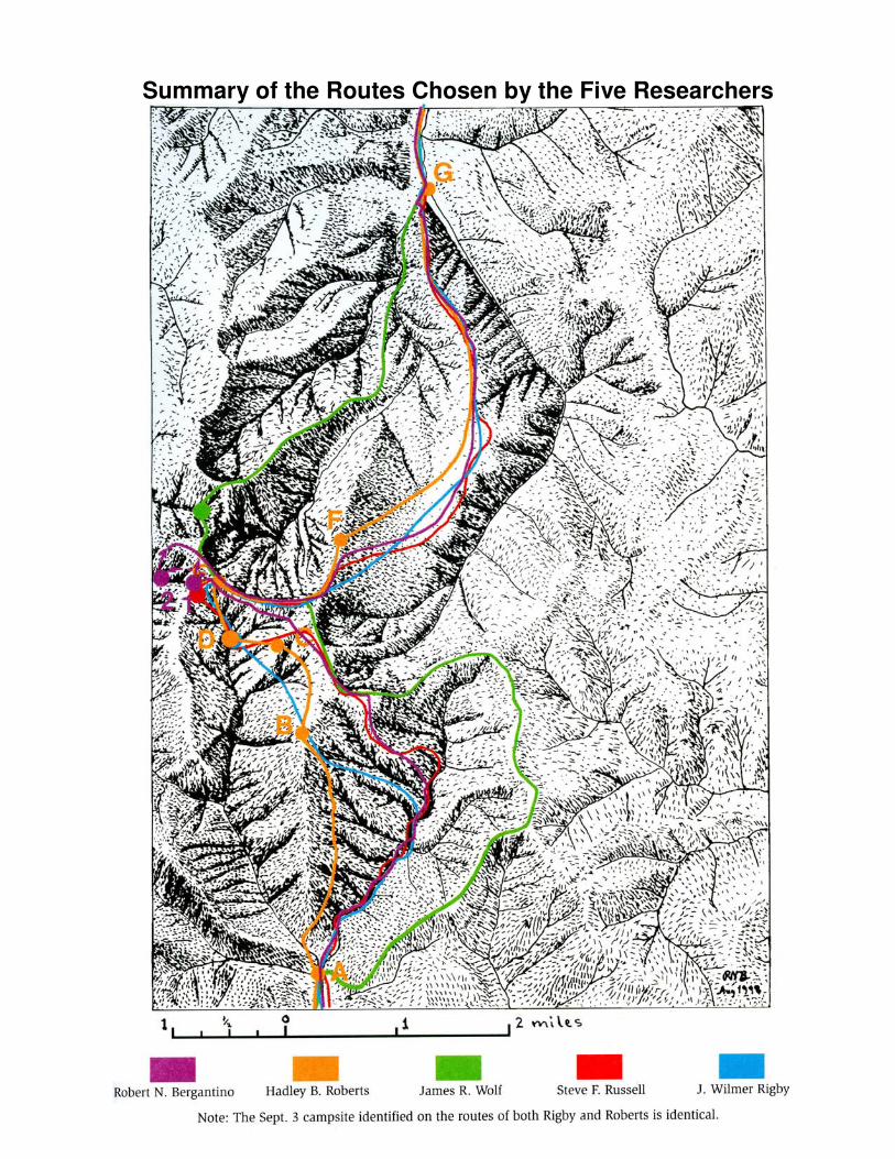
Summary of the Routes Chosen by the Five Researchers