the modern origins of china s south china sea...
TRANSCRIPT

https://doi.org/10.1177/0097700418771678
Modern China 1 –44
© The Author(s) 2018Reprints and permissions:
sagepub.com/journalsPermissions.nav DOI: 10.1177/0097700418771678
journals.sagepub.com/home/mcx
Article
The Modern Origins of China’s South China Sea Claims: Maps, Misunderstandings, and the Maritime Geobody
Bill Hayton1
AbstractThis article offers a new account of the development of China’s territorial claims in the South China Sea. It argues that a collective Chinese belief in a “historic claim” to the reefs and rocks therein emerged in distinct episodes during the first half of the twentieth century, partly in response to perceived threats to the country’s sovereignty but mainly as attempts to shore up declining nationalist legitimacy. It situates the claim within efforts by Chinese intellectual and state elites to construct a national “geobody” in the first decades of the twentieth century. It argues that this was not a process of documenting a preexisting claim but of imagining and asserting one through the mobilization of both emotion and archival documents. Moreover, this account emphasizes the importance of the acquisition of knowledge from foreign sources and the confusion that entailed. The legacy of this confused claim-making shapes South China Sea geopolitics today.
KeywordsParacel, Pratas, Spratly, sovereignty, territory, geography, U-shaped line, 9-dash line
1Asia-Pacific Programme, Chatham House, London, UK
Corresponding Author:Bill Hayton, Asia-Pacific Programme, Chatham House, 10 St James’s Square, London, SW1Y 4LE, UK. Email: [email protected]
771678 MCXXXX10.1177/0097700418771678Modern ChinaHaytonresearch-article2018

2 Modern China 00(0)
The origins of China’s claims in the South China Sea have been remarkably understudied given the amount of political attention those claims currently attract. Critically, the international debate around those claims is still being framed by a very few works published in the mid-1970s and early 1980s. As I have argued elsewhere (Hayton, 2017), these works relied on partisan Chinese sources and lacked historical context.
The “Chinese narrative” includes papers by Tao Cheng (1975) in the student-edited Texas International Law Journal in 1975, and by Hungdah Chiu, who worked with his Korean colleague, Choon-Ho Park, on a paper published the same year (Chiu and Park, 1975), the German Sinologist Dieter Heinzig (1976), and the American geographer Marwyn Samuels (1982). Only a few writers have looked at the history more critically: Monique Chemillier-Gendreau (2000), Chen Hsin-chih (2001), Ulises Granados (2005, 2006, and 2008), Francois-Xavier Bonnet (2004 and 2012), and Chris P. C. Chung (2016). Some Taiwan-based scholars have also begun to examine the historical narrative. They include Chen Hsin-chih (2001), Hurng-Yu Chen (2016), and Tsung-Han Tai and Chi-ting Tsai (2014). This article will develop their work and situate the emergence of China’s South China Sea claims within efforts by Chinese elites to con-struct and define an emerging state of China at a time of both foreign incur-sions and internal modernization.
The article will show how knowledge of the South China Sea among offi-cials and the general public was generated in distinct episodes: in 1909, 1928, 1933, and immediately after World War II. It will argue that ideas about China’s “rightful” territorial claims emerged in response to domestic political crises and were primarily aimed at domestic audiences. It is an account of Chinese officials grappling with Western doctrines of international law forced on them by rival states. It shows how officials and activists sought texts and maps as evidence to support their assertions. It goes on to demonstrate the importance of confusion, mistranslation, and emotion.
It also argues that the main vehicle for transmitting this emotion through the population was journalism. While the flaws of relying on newspaper accounts are well known, I use them here as a means of tracing the public knowledge of the issue and the efforts by government and other actors to influence public opinion. These newspapers became major actors in the pro-cess of constructing and asserting a Chinese maritime geobody among the wider public. Their accounts created, in effect, the Chinese commonsense knowledge about the South China Sea. Given that they were the ultimate source for the first English-language accounts of the disputes, they have also had a significant impact on international discourse.
Hayton 3
China’s Geobody
This article will seek to explain the development of China’s South China Sea claim through an application of Thongchai Winichakul’s notion of the “geobody.”
A nation’s territory is not simply a sizeable piece of the earth’s surface. It is a territoriality . . . the basic geographic expression of influence and power. . . . Geographically speaking, the geo-body of a nation occupies a certain portion of the earth’s surface which is objectively identifiable. It appears to be concrete to the eyes as if its existence does not depend upon any act of imagining. That, of course, is not the case. The geo-body of a nation is merely the effect of modern geographical knowledge whose prime technology is a map. (Winichakul, 1994: 16–18)
To put it more simply, the way people think about places has changed over time. As groups began to imagine themselves as nations (Anderson, 1991), they also began to imagine a territory upon which they would collectively exist: their geobody. Winichakul describes the emergence of Thailand from a region without formal borders. He outlines the process whereby “the geo-graphical discourse displaced the indigenous one, generating conflict, con-frontation and misunderstanding. . . . Those moments could appear in every sort of social activity: diplomatic relations, scientific observations, corre-spondences, travels, textbooks, warfare and, of course, surveys and mapmak-ing” (Winichakul, 1994: 18).
A few writers have applied the geobody concept to China. Robert Culp has argued that 1930s Chinese geography and history textbooks “worked together to produce an image of the Chinese nation as a geobody . . . an image of China as a cohesive territorial unit with fixed boundaries and unified sover-eignty” (Culp, 2007: 72). William Callahan has looked at the ways that car-tography became a means of describing China’s “national humiliation” at the hands of imperialist powers in the nineteenth and twentieth centuries and then a mechanism for mobilizing the population against those powers (Callahan, 2009: 146).
The accounts by Winichakul, Culp, and Callahan focus almost entirely on land, inhabited spaces, and the physical frontiers between states. However, similar processes also took place in relation to the reefs and islets of the South China Sea, which were permanent home to no one and where physical bound-aries were nonexistent. Nonetheless, twentieth-century Chinese intellectuals and state elites consciously constructed them as integral parts of China’s geo-body. As we shall see, nationalistic readings of historical territoriality were

4 Modern China 00(0)
repeatedly asserted in response to the political needs of the present. Over time these were accepted as facts and were used as foundations for subsequent readings so that early errors were repeated and amplified.
The assertions commonly made in Chinese sources about the history of the South China Sea can be traced back to just a few journalistic articles writ-ten in the months after July 1933. These texts were written in response to France’s annexation of six of the Spratly Islands that month. Those 1933 texts often refer, in turn, to an incident which first sparked official Chinese interest in the islands: the 1909 crisis over a Japanese guano-mining operation on the island of Pratas. As we shall see, 1909 was the moment China’s island claims first emerged. I will argue that this effort should be seen not as the concretiza-tion of a preexisting claim but as the construction of a new one. The claim-making was a deliberate political action with both domestic and international audiences. It was intended to defend the legitimacy of a regime under assault from within.
Rising Nationalism in Southern China
The process of defining modern China’s maritime geobody began as a response to violent upheaval in the southern part of the country during the first decade of the twentieth century. Anger against the imperial powers and against the failure of the Qing government to effectively resist them was widespread. Sixty years of “unequal treaties,” the loss of territory to Japan in the 1894–1895 Sino-Japanese War, and the international invasion to crush the Boxers in 1901 had prompted the formation of a large number of popular nationalist organizations (Rhoads, 1975: 150). This anger evolved into revo-lutionary activity after the foundation of the Tongmenghui (United Allegiance Society) by Sun Yat-sen and others in Tokyo in 1905. The Tongmenghui was dedicated to overthrowing the Qing and orchestrated a series of revolts against it, particularly in southern China. During 1907 four uprisings were launched in Guangdong and Guangxi alone. One of the reasons all these revolts failed was the leadership of Li Zhun 李準, brigade-general of Nan’ao, a coastal district in eastern Guangdong. According to Edward Rhoads, in 1907 “Li Chun [Li Zhun] was fast becoming the dominant military figure in Kwangtung” (Rhoads, 1975: 211). Critically, Li would also become a key figure in the development of China’s South China Sea claims.
One of the main criticisms of the Qing authorities in this period was their failure to resist foreign trespassing. On November 22, 1907, a group of stu-dents in Guangdong founded the Society to Recover the Nation’s Rights to campaign against planned British anti-piracy patrols of the West River (Rhoads, 1975: 132). Among them was the 19-year-old Chen Jiongming.
Hayton 5
Chen would later join the revolution but, in 1907, he was a constitutional reformer (Chen, 1999: 1). The students were joined by the Canton Merchants’ Self-Government Society, an organization of influential businessmen, tacitly supported by the local Qing commander, the viceroy of Liangguang (Guangdong and Guangxi). Similar groups were established in other south-ern cities (Rhoads, 1975: 132). At this time their main concern was that the British patrols would lead inevitably to the partition of China. The crisis was resolved by February 1908 when the viceroy appointed General Li as provin-cial naval commander with the rank of admiral and a mission to end piracy on the river (Straits Times, Feb. 14, 1908: 5, “Protection afloat and ashore”).1 This was accepted by the British and greeted as a great victory by the protes-tors. The episode lasted just a few months, but it prompted the formation of networks that later became the basis for further agitation.
Anxieties about foreign intentions along the southern coast continued to mount. On February 5, 1908, Li Zhun led an operation, in the waters between Macao and Guangzhou, to seize a Japanese freighter, the Tatsu Maru, smug-gling arms to anti-Qing rebels (Japan Weekly Chronicle, Feb. 27, 1908: 263, “The arrest of the Tatsu Maru”). In response, the Japanese government demanded the release of the ship and its cargo, a formal apology, compensa-tion, and the punishment of the officials involved. It threatened military action if the terms were not met, and on March 15 the Qing government agreed to pay compensation. On March 18, twenty thousand people joined a protest in Guangzhou organized by the Self-Government Society. A meeting of the Self-Government Society on March 20 designated the date the Tatsu Maru was released as National Humiliation Commemorative Day. There were “national humiliation” meetings, including one attended by “thousands and thousands of women” at which they urged everyone to wear a ring engraved with the phrase (Rhoads, 1975: 135–37). A Society to Commemorate the National Humiliation was formed in Guangzhou at around the same time.
The March 20 meeting also declared a boycott of Japanese goods and services which, under pressure from Japan, the central government banned. While the central government tried to suppress the boycott, Japan complained that the viceroy of Liangguang, Zhang Renjun 張人駿, was sympathetic to it. Given that Zhang was attempting to suppress uprisings fueled by the supply of smuggled Japanese weapons, his attitude was hardly surprising (Wong, 1993: 86–87).
Subsequent incidents prolonged the agitation. In April 1908, fears were expressed over whether France might try to snatch the island of Hainan in order to link its enclave at Guangzhouwan (on the Leizhou Peninsula) with Indochina (Singapore Free Press and Mercantile Advertiser, April 20, 1908: 5, “The French in South China”). In November 1908 there were more

6 Modern China 00(0)
demonstrations over the death of a Chinese passenger aboard a British-owned ship, the Fatshan (Rhoads, 1975: 141). Up until this point, although the anger was about events along the coast and just offshore, its focus was on the humiliation of the Chinese state authorities—and by implication, the Chinese people—on land. However, the next episode would, for the first time, link nationalist sentiment with the fate of offshore islands themselves.
Chinese Knowledge of Offshore Islands before 1907
It seems reasonable to assume that those Chinese who used the sea—fishing communities and maritime traders—were well aware of at least some of the offshore islands within it. We know that the East India Company hydrogra-pher Daniel Ross used local pilots in his surveys of the Chinese coast between 1806 and 1817, for example (Davies, 2006). However, there is little evidence of any interest in them among state officials or the wider Chinese population until the first decade of the twentieth century. Claudine Salmon has noted that, “unlike the Yuan, the Ming and the Qing were not interested in incorpo-rating big maritime spaces into their empire in order to increase the territory of their state” (Salmon, 2006: 178). Li Zhun himself would complain, a quar-ter of a century later, that “the territorial sea was not a prime concern in Chinese history. Consequentially, China has neither the nautical charts nor the knowledge of foreign invasions of nearby islands for thousands of years” (Li, 1933: 1).
While there are several examples of Chinese coastal navigational maps dating back many centuries, none extend more than a few miles offshore. Some indicate islands within the main body of the South China Sea but with only vague indications of location. Ronald C. Po notes how a particular map, the Yanhai tu (Coastal Map of the Seven Provinces), “divides the maritime frontier into an inner sea space (neihai) and an outer sea space (waihai).” He argues that during “the long eighteenth century (1683–1839),” Qing officials, “tended to perceive the inner sea as the farthest extent of their maritime authority, a region legitimately subject to sustained governance and state pos-session; whereas the outer sea space was considered a capricious blue-water domain beyond the reach of administrative control and economic extraction” (Po, 2016: 112).
The boundary between neihai and waihai was not formally defined but varied according to place; it could be closer to land at the mouths of estuaries, for example. Po notes that in Fujian it lay at the point where visibility from land ceased. He also notes that on the Yanhai tu, the neihai was further sub-divided into neiyang and waiyang with the latter (the “outer inner sea”) as strategically important (Po, 2016: 115–16). Dian Murray suggests the line
Hayton 7
between neihai and waihai lay where “the shallows deepened” (Murray, 2004: 55). Po relates imperial edicts declaring the navy responsible for con-trolling the “inner sea.” This notion of the maritime boundary is not too dis-similar to the Western notion of a territorial sea based on the so-called cannon-shot rule—the area that could be policed by the state (Po, 2016: 115).
The Yanhai tu was redrawn and republished several times between the 1780s and 1881. Toward the end of this period, Western-style hydrographic chart-making entered China through the establishment of the Imperial [later China] Maritime Customs Service in 1854. This was a hybrid body, nominally under the Chinese imperial court but commanded and run by foreigners (Van de Ven, 2014). Research by the maritime historian Stephen Davies finds no record of a Chinese draftsman employed by the service until 1917. However, from the 1870s, Chinese publishers began to copy British Admiralty charts and a few Chinese cadets (35 in number) were sent to the Greenwich Royal Naval College in London where they learned charting skills. Nonetheless, it was not until September 1921 that the Chinese Navy Hydrography Bureau could deploy a full survey team into its coastal waters (Davies, 2006).
At the start of the twentieth century, therefore, the Qing state was aware of its coastal domain but assumed no responsibility for islands more than a few miles offshore. This apparently became an issue in the 1890s following the looting of copper from two foreign ships wrecked on the Paracel Islands: the German-owned Bellona in 1894 and the Japanese-owned Himeji Maru in 1896. A note, dated May 4, 1909, from Joseph Beauvais, consul of France in Guangzhou, to the French minister for foreign affairs recounts an exchange with the southern Chinese authorities from the time of the wrecks. “The then Consul of Great Britain in Hoihow [Haikou] . . . lodged a request for compen-sation. The Chinese Government rejected this, precisely on the grounds that the Paracels were not part of the Chinese Empire” (Chemillier-Gendreau, 2000: 200–203).2
The Pratas Island Crisis of 1909
The political and diplomatic crisis over the tiny island of Pratas in 1909 would change this. Southern officials of the Qing state were forced to engage with Western concepts of international law, mobilize evidence, and physi-cally assert territorial claims to uninhabited islands far offshore. Just as importantly, a part of the Chinese population, concentrated in cities along the southern coast, would form a psychological attachment to places of which it had only the barest knowledge.
Before 1907, there was very little interest in Pratas from any government. Pratas is a coral reef, around 20 kilometers in diameter, approximately

8 Modern China 00(0)
halfway between Hong Kong and Taiwan, upon which sits an island just under 3 kilometers long and 1 kilometer wide. According to Li Zhun’s account, published in 1933, “Fishermen from Guangdong and Fujian who travel between those places sometimes drifted to the islands because of the bad wind. Notwithstanding, the fishermen made a profit from the islands and hence the Guangdong idiom: ‘Want to get rich, go to Dongsha’” (Li, 1933: 1). The British naturalist Cuthbert Collingwood visited it aboard HMS Serpent in 1867, reported it was “occasionally visited by Chinese fishermen,” and found a dilapidated wooden temple (Collingwood, 1867: 147).
The (British) Royal Navy had surveyed Pratas in 1858 (Collingwood, 1867: 145) and again in 1889 (Hancox and Prescott, 1995: 36) and there had been sporadic discussion of the need to build a lighthouse there. However, no government was willing to spend the necessary money (Hongkong General Chamber of Commerce, 1932: 32). In November 1903, the American authori-ties in the Philippines claimed to have uncovered an arms smuggling opera-tion using Pratas and dispatched their own coast-guard vessels to investigate. Significantly they do not seem to have asked the Chinese or any other gov-ernment for permission to do so. They regarded the reef as ungoverned (South China Morning Post [hereafter, SCMP], Nov. 18, 1903: 3, “Love’s labours lost: a good hoax”).
A Japanese Merchant on Pratas
The first mentions in the English-language press of any Japanese interest in Pratas appear in September 1907. A report in the Times of London states that, “The rumour that Japan contemplated the establishment of a naval station on Pratas is wholly without foundation. It originated in a mistake by a private explorer who imagined that he himself had discovered the island” (Times, Sept. 9, 1907). The Hong Kong Daily Press carried more detail the following month, citing “a telegram from Yokohama to the New York Herald” as the source of the story and implying concern about Japanese naval ambitions (Hong Kong Daily Press, Oct. 5, 1907: 2, “Japan seizes Pratas”). The “private explorer” was a Japanese entrepreneur, Nishizawa Yoshiji, who was mining guano on the island. Guano was a valuable fertilizer at the time. Japanese merchants were particularly active in exploiting it on many Pacific atolls (Granados, 2008: 123).
The United States government was worried about possible implications of the Pratas occupation for its recently acquired colony in the Philippines. U.S. Secretary of War William Taft raised the issue directly with the Qing govern-ment on his visit to China in December 1907. The United States was said to be considering whether to formally support a Chinese claim, although no

Hayton 9
decision had been taken (Hong Kong Daily Press, Dec. 7, 1907: 2, “Japan and the island of Pratas”). From the evidence available, it seems that the Qing court took no immediate action in response to Taft’s intervention.
However, in April 1908, the Singapore Free Press and Mercantile Advertiser reported that, “When asked as to whether the statement Japan had seized an island to the South of Hongkong, known as the Pratas Island is true, the Admiral [Li Zhun] replied that he was making investigations and did not care to say much on that question” (Singapore Free Press and Mercantile Advertiser, April 20, 1908: 5, “The French in South China”). The English-language media remained quiet on the subject for almost another year until a story suddenly appeared in the South China Morning Post (SCMP) on March 15, 1909. The newspaper reports that “some time ago” a Chinese gunboat discovered Japanese on the island and reported the matter to the viceroy of Liangguang, who dispatched “several officers,” including one who could speak Japanese, to investigate further (SCMP, Mar. 15, 1909: “Official investigation”). The SCMP’s second report, the following day, noted that “the local Chinese mind has been agitated somewhat” by the reports of the Japanese presence on the island and that “the Chinese in the south are not taking the matter kindly,” suggesting that there had been public protest over the issue (SCMP, Mar. 16, 1909: 7, “Japanese on the Pratas”). The China Mail that day was highly critical of the Chinese authorities, say-ing, “It seems very singular that the authorities at Canton should have only just awakened to what is occurring at the Pratas” because Japanese newspa-pers had printed full details about it, “about a year ago” (China Mail, Mar. 16, 1909: 4, “The Pratas”).
News of the occupation of Pratas had clearly reached the Chinese authori-ties via Japan and the United States in 1907, but it seems that it was not until early 1909 that they responded. The SCMP of March 6, 1909, refers to Chinese fishermen being “persistently driven off” by Japanese occupiers and requesting protection from the viceroy. According to an account in the Kobe-based Japan Weekly Chronicle, quoting one of the Japanese who was on the island at the time, a gunboat of the Imperial Chinese Navy, the Fei-Ying, “suddenly appeared” on March 1, 1909. The ship’s second officer came ashore, “accompanied by an Englishman and said that the gunboat was on her way from Canton to Manila and had called in at the island to see what was going on there.”3 The paper goes on to say that “on the 10th of the same month the gunboat ‘Fei-Ying’ and the cruiser [of the Imperial Maritime Customs Service] ‘Hai-Yung’ arrived and two Chinese civil officials, accom-panied by two Chinese of the merchant type, five other Chinese, an inter-preter and three Europeans visited the office of Mr Nishisawa [sic]” (Japan Weekly Chronicle, July 15, 1909: 106, “The Pratas island question”).

10 Modern China 00(0)
Twenty-four years later, Li Zhun would recount his own version of events for a Chinese newspaper.4 According to this account, when he arrived at Pratas aboard the vessel Fupo (Fubo 伏波; Li does not mention a vessel called “Fei-Ying” that was noted in the newspaper account above; he later traveled to the Paracels aboard the Fubo, and it is possible that one or the other account here has the name incorrrect), he discovered that the island was occupied by Nishizawa and over a hundred laborers mining guano under a Rising Sun flag. Nishizawa told Li that he had discovered the island “more than two years ago” and, since it was unoccupied and close to Japanese-occupied Taiwan, had claimed it for Japan. Li’s ship then returned to the mainland so that he could “discuss the matter with General Zhang,” the vice-roy (Li, 1933: 2).
It was after Li’s return from Pratas that he and colleagues in the Liangguang administration took the first steps in what would become a decades-long pro-cess of constructing a territorial claim to the features of the South China Sea within the Western rubric of international law. According to his account, pub-lished twenty-four years later,
I tried to source nautical charts externally as evidence. But the plan did not work, as the charts were drawn up by foreigners and called the islands Pratas 布那打士. We searched old Chinese maps, books, and the Guangdong Provincial Gazetteer and could not find such a name. Observer Wang Xuecen, who reads extensively, informed me: “In the time of the Qianlong emperor [1735–1796], the general of Gaoliang, Chen Lunjiong, wrote a book titled Record of Sea Nation Observations, in which the name of that island is recorded.” We used that book to negotiate with the Japanese about the return of the island. (Li, 1933: 2)
According to Rhoads, at the same time as Li was searching old documents, the Self-Government Society collected evidence “from old published accounts of travelers to the oral testimony of local fishermen, to prove that the islands were historically Chinese and to refute Nishizawa’s claim of discovery” (Rhoads, 1975: 141). This appears to be the first moment that Chinese public opinion—or at least some part of it in a few southern port cities—began to take an interest in the sovereignty of the South China Sea islands.
On March 19 the SCMP reported that the viceroy “has deemed it expedient in the interests of peace, to prohibit the vernacular Press making further refer-ence to the subject of an inflammatory nature or otherwise” (SCMP, Mar. 19, 1909: 7, “Pratas Island—Japan’s disclaimer believed to have been no man’s land”). Nonetheless, according to Rhoads, “On April 11, a mass meeting of gentry, merchants, and students at the Confucian Temple in Canton added

Hayton 11
their support to the society’s effort. As a result of this excitement, the [anti-Japanese] boycott revived momentarily” (Rhoads, 1975: 141). Under pressure from the boycott, the Japanese government quickly declared that it had never staked a claim to Pratas and agreed to enter negotiations about its sovereignty. In May, during these talks, the Guangdong administration deployed “docu-ments showing that the islands had long been used by Chinese fishermen and that they had been regarded by the British and others as belonging to the Celestial Empire,” according to the SCMP (SCMP, May 7, 1909: 7, “The Pratas Islands: a new development”).
“Discovering” the Paracel Islands
Even before the negotiations had formally begun, Li Zhun came to hear of another maritime territory previously unknown to him: the Paracel Islands. According to Li’s 1933 account, he had been informed of their existence by the commander of the Left Fleet, Lin Guoxiang, an experienced sailor. Li lobbied the viceroy to order an official expedition to the Paracels to prevent foreigners from occupying them (Li, 1933). The viceroy agreed and, upon his request, at the end of March the Imperial Maritime Customs Service trans-ported three of his officers aboard its cruiser K’ai pan (Kaiban 開辦) to investigate the situation. According to Joseph Beauvais, French consul in Guangzhou, the K’ai pan had been “used for many years on surveillance duties off the coasts of southern China, its crew having a thorough knowledge of the seas around Hainan and the Gulf of Tonkin” (Chemillier-Gendreau, 2000: 200–203).
This account reinforces the notion that knowledge of the offshore islands among mainland officials was limited, compared to that of the foreign-run Customs Service and the various Western navies. When the K’ai pan returned to Hong Kong on April 15, 1909, it apparently “caused wonder in the local population by exhibiting 20 or so enormous turtles brought back from these deserted islands.” Its officers also reported that seven islands were covered with coconut palms and that salt production could be successfully undertaken there (Chemillier-Gendreau, 2000: 200–203; SCMP, April 20, 1909: 7, “China and her islands”).
This seems to have emboldened the southern elite. In late April the viceroy ordered two daotais (circuit intendants) to organize a full inspection of the Paracels and Li Zhun to assist them. They arranged a very high-ranking del-egation to sail to the islands and formally claim them. According to the SCMP, their purpose was to survey and possibly colonize the islands “to remove any doubt about ownership in future” (SCMP, May 7, 1909: 7, “The Paracels: surveying party despatched”).
12 Modern China 00(0)
Three vessels (a French observer at the time called them “small Cantonese gunboats” (Chemillier-Gendreau, 2000: 100)—the Fupo, Chinhao, and Kwongkum—left Guangzhou around May 14, 1909, with 106 people aboard and stopped in Hong Kong until May 21. The SCMP report of that day noted that “the recent Pratas affair appears to have awakened the Chinese authori-ties of the necessity for looking after their interests in the islands which are far removed from the coast-line” (SCMP, May 21, 1909: 7, “Off to the Paracels”). The flotilla then headed on to Hainan with stops in Haikou, Sama Bay, and Yulinkan, where they were becalmed and then delayed by a typhoon. At this point, the Kwongkum had to return to Haikou.
Great efforts appear to have been made to publicize the Qing authorities’ boldness in standing up to foreign threats to the islands’ sovereignty. Traveling with the flotilla was a German radio engineer called Brauns who transmitted news of its progress to local newspapers. The Fupo and Chinhao then headed to the Paracels where they spent three days exploring the archipelago. Li Zhun declared Chinese sovereignty over them in a manner familiar to the imperial powers: firing cannon volleys, hoisting flags, and giving the islands new Chinese names. One island was named Fubo 伏波 and another Chenhang 琛航, after the ships; another, Ganquan 甘泉, because of the presence of a well, and others in honor of senior officials. It is not clear when the Chinese name for the Paracels, Xisha 西沙, was coined. It may have been at around this time, because Li discusses the apparent symmetry between the Pratas as the Eastern Sands (Dongsha 東沙) and the Paracels as the Western Sands (Xisha) (Li, 1933).
The return of the ships to Hong Kong on June 9 should have been another opportunity for Li and the Guangdong authorities to proclaim their patriotic credentials. In Li’s later account, the viceroy “was exceedingly excited, as he believed that the nautical map of our country had expanded to include the fourteen Xisha Islands. . . . My colleagues and local gentlemen all rushed here to ask questions. I was absolutely exhausted after explaining everything” (Li, 1933: 8). However, at the time, the SCMP reported the “extreme reti-cence” of the officials who took part in the expedition to talk to its correspon-dent (SCMP, June 10, 1909: 7, “Paracels Islands: Chinese official mission returns”). It seems they were underwhelmed by what they had discovered.
Not long afterward, the viceroy had a patriotic victory in the negotiations over Pratas, albeit at a high price. On October 11, 1909, the Japanese govern-ment formally recognized Chinese sovereignty over the reef. In exchange, the viceroy agreed to pay Nishizawa 160,000 silver dollars in compensation for the confiscation of his investments on the island and Nishizawa agreed to pay 20,000 dollars in back taxes and for destroying a fishermen’s shrine on the island (Japan Weekly Chronicle, Oct. 21, 1909: 730, “Settlement of the
Hayton 13
Pratas Island question”; Straits Times, Oct. 28, 1909: 7, “The Pratas settle-ment: China to receive island back on certain terms”).
The practicalities of economic development were more difficult, however. In August 1910, the Guangdong provincial authorities attempted to restart guano extraction on Pratas. Lacking the necessary knowledge, they con-tracted Nishizawa’s firm to run it on their behalf! However, they failed to make the enterprise profitable and abandoned it a few months later (Straits Times, Dec. 23, 1910: 7, “The Pratas Islands: unprofitable speculation by China”). According to Li Zhun, the situation became worse “after the consti-tutional reform” (presumably the 1911 Revolution) when the mainland authorities failed to resupply the people living on the island and they starved to death (Li, 1933: 2).
The Paracels were almost as disappointing. The initial hopes of turning the islands into a profitable venture dissipated almost as soon as the flotilla returned to port. By late June, expectations were so low that the Guangdong authorities were proposing “converting the inhabitable portions of the Paracels into a penal settlement, the convicts to be employed in agricultural pursuits and timber working on Tree Island” (SCMP, June 21, 1909: 2, “Local news”). There is no evidence that even this venture actually happened. At some point in late 1909 the viceroy formally placed the Paracels under the authority of Qiongyai (Hainan Island prefecture), but his dreams of riches never came true.
In November 1911, Li jumped from the sinking ship of the Qing Empire and agreed to help the revolutionaries in exchange for his and his family’s safety. However, he fled Guangzhou only a week later (Rhoads, 1975: 226, 235). Li seems to have retired from public life at this point but would reemerge in 1933 with an intervention that would redirect the Chinese claim to the islands of the South China Sea.
Impact of the 1909 Expeditions
The events of 1909 were the first occasion when an influential section of the Chinese population developed and asserted an emotional claim to the fea-tures of the South China Sea. In other words, it was the beginning of the process of constructing China’s maritime geobody. Large numbers of people followed developments in the media, attended demonstrations, and observed boycotts. As the above account shows, this only happened because of the already simmering anti-Japanese sentiment in southern China. While nation-alists used the Pratas and Paracel episodes to attack the legitimacy of the central Qing government, local officials used them to legitimize their own authority against that of the revolutionary Tongmenghui.

14 Modern China 00(0)
Significantly, Chinese officials felt it was not enough for them to simply assert that Pratas was a part of China: they needed to prove the case to another government. They collected documentary evidence and presented it in the form of an international legal argument. This was a mode of state behavior that had only been implanted in Chinese governing circles a few decades before. Henry Wheaton’s Elements of International Law had been partially translated into Chinese in 1863 and its principles deployed the following year in a dispute with Prussia in the case of three Danish ships captured near Tianjin. In Rune Svarverud’s account, China’s success in that episode led to Wheaton’s concepts gaining wider official acceptance (Svarverud, 2007: 90). However, it was China’s defeat in the Sino-Japanese War and the subsequent 1895 Treaty of Shimonoseki that “forever changed China’s interpretation of itself in inter-state relations” (Svarverud, 2007: 163). The Qing court was forced to realize that the Sinocentric regional order had collapsed and its rela-tions with other states would henceforth be based on Western principles.
In retrospect, the Liangguang officials were attempting to prove something they believed to be true—that Pratas and the Paracels were Chinese—but within the international discourse of sovereignty. This demanded documentary evidence of occupation and administration. The act of proving that case must have been, in itself, a humiliation but much less of a humiliation than losing the islands to Japan or another imperialist power. The events of 1909 were, in effect, part of a long process of adjusting the official Chinese attitude toward marine territory from one of tianxia (all under heaven) to Westphalia.
From the Nationalist Revolution to the French Annexation
The turmoil in China following the demise of the Qing regime in 1911 makes establishing a definitive timeline of events in the South China Sea difficult. The evidence suggests a rapid decline in interest in the islands even before the revolution. Grandiose plans to colonize the Paracels seem to have been abandoned almost immediately after the 1909 flotilla. The Guangdong authorities refused to pay for lighthouses there in 1913, even though shipping companies were demanding them. Ships continued to wreck on the reefs and in 1920 the SCMP described the Paracels as a “death trap” (SCMP, Dec. 1, 1913: 6, “Paracels Reef: the need for a light”; SCMP, April 20, 1920: 3, “The Paracels death trap”).
China broke into competing fiefdoms in 1916 and it was not until 1921 that the Paracels again became a topic of interest to Guangzhou. Sun Yat-sen’s rebel southern government licensed the Paracels Archipelago Industries Company Ltd. 西沙群島實業無限公司 to mine guano on the islands. This
Hayton 15
prompted a dispute between the Guangdong authorities and those of Qiongyai (Hainan), who had been formally placed in charge of the islands in 1909 (Granados, 2005: 448–49). Allegations circulated that the Paracels Company was a front for Japanese interests and there were demands for its license to be revoked. Ulises Granados has explored this murky history. British intelli-gence files suggest that Sun Yat-sen was well aware of the Japanese interests behind the company. On February 22, 1922, he had signed an agreement with the Japan-China Forestry, Mining and Industrial Society, in which he pledged “the development rights of Hainan Island and all islands belonging to Guangdong province” in exchange for five million gold yen and a large amount of military supplies (in violation of the then arms embargo on the internationally unrecognized government). The owner of this society was one Hirata Sueji, who was also alleged to be behind the Paracels Company. All this came to light when Sun was temporarily overthrown by the Guangdong military commander, the former student reformist Chen Jiongming, in June 1922 (Granados, 2005: 454–55).
According to Granados, British intelligence sources reported that in July 1922 and March 1923, “the southern government also negotiated a so-called ‘Hainan Loan’ with a Japanese national (the individual’s identity is not known, but speculation points to Hirata) so as to cede all development rights of the island in exchange for an alleged sum of 20 million yen” (Granados, 2005: 454–56). Sun’s military forced Chen to flee Guangzhou in early 1923 and the reinstalled authorities appear to have been untroubled by the situation in the Paracels for the following six years, although there are reports of patrols sent to the islands in 1923 and 1926 (Granados, 2005: 449).
It was only when the southern government was on the verge of reuniting China that the Guangdong authorities came to consider the islands again. In February 1928, Guangdong officials convened a conference and mandated a Professor Shen Pengfei 沈鵬飛, of the Sun Yat-sen University in Guangzhou, to investigate the situation on the Paracels. More research is required to understand why such a decision was taken at this time. One reason was prob-ably because of changing attitudes toward Japan. Rather than being a sponsor of the southern government, Japan was now regarded as a distinct military threat. It is also possible that the expedition may have been a way for the Guangzhou authorities to legitimize their nationalist credentials. The confer-ence took place just two months after the Communist-led Guangzhou Uprising. Warlords had suppressed the rising in three bloody days between December 11 and 13, 1927. Over the following week they executed at least 5,000 people, many of them simply beheaded in the street (Dirlik, 1997: 363). It is possible that the islands of the South China Sea may, once again, have been seen as a means of popular legitimation.

16 Modern China 00(0)
According to Shen Pengfei’s account, his expedition departed Guangzhou on May 22, 1928, and returned seventeen days later. It discovered that the Paracels Company was indeed operated by Japanese and that, in fact, the Japanese Southern Prosperity Industries Company had been active in the Paracels since 1919 without permission from any government. It also learned, for the first time, that French officials had visited the islands. The Indochina Institute of Oceanography, based in Nha Trang on the central Annam coast, had sent its research ship the de Lanessan to the Paracels in mid-1925. Shen discovered that it had docked at the Paracels Company’s jetty on Woody Island on July 25, 1925, and again on July 3, 1926. It seems the Chinese authorities had been entirely unaware of these developments. Shen’s report of the trip noted that “our people have paid [the archipelago] little attention and the natural resources have been coveted by foreigners” (Samuels, 1982: 55–58; Granados, 2005: 449; Sasges, 2016).
Shen’s Reports on the Investigation of the Paracel Islands 調查西沙群島報告書 was published by Sun Yat-sen University Press later in 1928. It was intended to guide plans for developing the islands and protecting Chinese sovereignty over them. Shen began the report with a confident declaration: “The Paracel archipelago is our nation’s southernmost territory” (Samuels, 1982: 56). That was presumably intended to be an assertive statement of claim to the islands. In retrospect it is at least as significant for denying any Chinese interest in the Spratly Islands further south. At the same time the Guangdong authorities also commissioned a publication from a Guomindang member, teacher, and history book author, Chen Tianxi 陳天錫, setting out evidence in support of their claim to the islands: A Compilation of Materials Concerning the Xisha and Dongsha Islands Case 西沙島東沙島成案彙編 (Chinese Biographical Database, 2010; Chen, 1928).
This 312-page document became the model for a mode of mobilizing sup-port for the Chinese claim to the islands. Picking up where Li Zhun and the nationalist movement had left off in 1909, it included evidence from an eclec-tic mix of sources in support of the argument that the Paracels had “always” belonged to China. These were often single lines from old documents that mentioned islands, shorn of any contextual information. One example was a note by the fourth-century Buddhist monk Faxian about his travels, which describes a sea voyage from India back to China. A more careful reading of Faxian’s account shows that he traveled on a Malay vessel and had no interest in claiming any territory (Stuart-Fox, 2003: 32). Examples such as this give us some clues about the purpose of documents such as Chen’s. They were published in Chinese but not in English or other international languages. Their envisioned audience was therefore Chinese. These documents were intended to provide a basis to claim the islands as Chinese territory. Rather
Hayton 17
than documenting a “natural,” preexisting claim, their purpose was actually to generate something new.
This was how the Chinese maritime geobody was constructed. Officials and activists sought to underpin a sense of national entitlement with some-thing that could be called evidence. Moreover, they attempted to translate that sense of entitlement into the modern world system by deploying the proof of discovery and administration required by Western doctrines of international law. Yet these officials appear not to have presented it to the outside world. Their purpose was to convince their own populace about the rightness of their cause.
Patriotism and Cartography
Despite these developments, Chinese nationalist opinion seems to have ignored the islands for almost a quarter of a century, from 1909 to 1933. They did not feature in the demands of the May Fourth movement in 1919, for example, which was focused on the Shandong Peninsula. However, the islands did become embroiled in efforts to formally define China’s territorial boundaries.
As William Callahan has described, there was considerable anxiety among Chinese intellectuals about where those boundaries should be drawn. This is obvious from contemporary cartography. Conscious that sections of the Qing realm had been “stolen” by foreign powers, the first official map of the Republic of China showed no defined borders at all. Published in the Republic of China’s (ROC’s) first Almanac 中華民國元年曆書 in 1912, the boundary between what was and was not Chinese was left vague. In the absence of official definition, the intellectual debate about China’s boundaries was joined by number of private cartographers, such as the mapmaker Hu Jinjie 胡晉接; civic organizations, such as the Shanghai Cartographic Society; and private companies, such as the Zhonghua Book Company. Each produced their own map of national humiliation—as a means of educating their fellow patriots about the loss of China’s rightful territory by contrasting China’s existing and “rightful” borders. Each map was different; there was no consen-sus about what was rightfully China’s (Callahan, 2009: 155).
The maritime domain played only a small part in this process. A map in Hu Jinjie’s atlas of December 1914 was entitled Chinese Territorial Map before the Qianlong-Jiaqing Period 前清乾嘉以前中華領域圖 (i.e., before 1735–1820) and included a line encompassing just Pratas and the Paracels (Zou, 2007: 88).5 The idea behind this map may have come from the document that Li Zhun discovered in 1909. However, by 1927 the Zhonghua Book Company’s Map of National Humiliation included the whole of mainland

18 Modern China 00(0)
Southeast Asia, northern Borneo and the Sulu Islands within a line labeled the “old national boundary” (Callahan, 2009: 155). The best explanation for why the map was drawn this way is probably that the cartographer believed that places that had sent tribute to Chinese emperors in the past, such as the Sultanate of Sulu, should be considered part of the Chinese empire. The South China Sea was encompassed by this line but only really as a by-product of the inclusion of peninsular Southeast Asia and northern Borneo. The islands were not the focus of the map: the Spratlys were not even marked.
This period of official cartographic uncertainty began to end after the establishment of a new central government under the Guomindang of Chiang Kai-shek (Jiang Jieshi) in October 1928. Just over a year later, in January 1930, the new government promulgated the Inspection Regulations of Land and Water Maps 水陸地圖審查條例.6 The regulations mandated the forma-tion of a Land and Water Maps Review Committee 水陸地圖審查委員會, with representatives of government ministries, to inspect Chinese maps and specify what they could and could not display. The process would, in effect, define China’s official geobody. Given its significance in China’s later terri-torial disputes, this is a much understudied body. We do know that problems with funding and the worsening political situation prevented the committee from actually convening for three years. It finally held its first meeting on June 7, 1933, coincidentally as the next South China Sea crisis was about to begin (Li and Li, 2003: 289).
The Spratly Annexation Crisis
The next episode in the South China Sea would have two major conse-quences. Firstly, concern about the fate of remote rocks and reefs would become a national (as opposed to a regional) issue for the first time. Secondly, it would spark a chain of misunderstandings, as a result of which the Chinese territorial claim would expand southward to accidentally include the Spratly Islands.
On December 4, 1931, the French government, as the colonial power in Indochina, had formally protested Chinese plans to further develop the guano industry in the Paracels and, for the first time, formally claimed sovereignty over them. It justified the claim based on the actions of Vietnamese rulers in the early nineteenth century (Chen, 2001: 7). On June 15, 1932, the French protectorate of Annam formally incorporated the islands into the central coastal province of Thua Thien. On July 27, 1932, the Chinese legation in Paris was instructed to formally reject the French claim. Its note (apparently not delivered until September 29—Chen, 2001: 8) put forward several argu-ments that continue to be used to this day:
Hayton 19
•• That the 1887 Sino-Tonkin Convention allocated islands east of 108° 2′ E to China
•• That “historically, only the residents of Qiongyai [Hainan] went there to fish and mine; it was unheard of any Annam residents were there”
•• That any act of sovereignty over the islands undertaken by Vietnamese emperors in the nineteenth century was null and void because Annam was a vassal of China at the time
•• That Guangdong province had approved at least five mining conces-sions on the islands since 1921
•• That, at the 1931 Far East Meteorology Conference, the head of the Annam Observatory, a Frenchman named E. Bruzon, had recom-mended to the Chinese representative that China build a weather sta-tion on the islands. (Ministry of Foreign Affairs, 1933: 209–10; Samuels, 1982: 61–62)7
Notably, at least according to French records, the note included the observa-tion that the Paracels form the southernmost part of Chinese territory. There was no mention of the Spratlys (Chen, 2001: 8).
However, at the same time, the Chinese Ministry of Foreign Affairs was facing another, more dangerous, crisis. Japanese forces had invaded Manchuria in September 1931 and made further incursions into northeastern China during the first half of 1933. Unable to drive them out, the Nanjing government had been forced to agree to the Tanggu Truce, the de facto recog-nition of the Japanese puppet state of Manchukuo in May 1933. This ulti-mately served to legitimize Japanese efforts to split more areas of northern China away from Chinese control.
The truce sharpened the disagreements between the central government in Nanjing and rival political leaders based in Guangzhou. In December 1931, the anti-Chiang factions in the Guomindang had converged there and formed themselves into an autonomous government under Hu Hanmin: the Southwest Political Council 西南政委會. According to John Hunter Boyle, this was nom-inally an arm of the Nanjing government but in reality, a separatist regime governing Guangdong and Guangxi: “It could, and did, embarrass the Central Government by condemning its temporizing policies toward Japan” (Boyle, 1972: 42). According to Diana Lary, its main activities “were verbal assaults on Nanking, usually self-righteous attacks on Nanking’s failure to resist Japanese advances” (Lary, 1974: 161). These disagreements would have a profound influence on the development of Chinese claims in the South China Sea.
The background to the annexation by France of six of the Spratly Islands has been examined by Geoffrey Gunn (1991), Chen Hsin-chih (2001), Stein Tønnesson (2006), and Gerard Sasges (2016). To condense a complex story

20 Modern China 00(0)
considerably, “on 13 April 1930, the commander of the French warship Malicieuse took formal possession, on behalf of France, of Spratly Island ‘and the islets depending on it’” (Tønnesson, 2006: 4–5). However, the French authorities failed to formally publicize the annexation (although news of the event was printed in a few newspapers). The British government objected on the grounds that international law did not allow the annexation of “dependent islets” or wide areas of sea but only of defined features.
In 1933, prompted by an inquiry from the British government and con-cerns about Japan’s intentions, France re-annexed Spratly Island plus five others by name: Amboyna Cay, Itu Aba, North Danger Reef (Les Deux Îles—Northeast and Southwest Cay), Thitu, and Loaita. The ships Alerte and Astrolabe visited the islands between April 7 and 12, planting flags and firing cannon. News of the annexation was released on Bastille Day, July 14, 1933, reported in some French newspapers (e.g., L’Illustration) the following day (U.S. Dept. of State, 1933), and a formal announcement was printed in the Journal Officiel on July 25 and 26 (Journal officiel de la République fran-çaise, July 25, 1933: 7794, and July 26, 1933: 7837).
We can trace the Chinese reaction to the annexation through reports in the Shanghai-based Chinese-language newspaper Shenbao, a few editions of Chinese-language magazines, and the English-language North China Herald (published in Shanghai), and the Hong Kong–based South China Morning Post. Shenbao carried the Bastille Day announcement the day after it was made, with reports from correspondents in Paris, Manila, and London. They noted the latitude and longitude of the islands as announced by the French government and that they were between Saigon and the Philippines. Importantly, they noted French reports about the presence of Chinese fisher-men on the islands (Shenbao, July 15, 1933). However, it is immediately clear from the reporting that there was much confusion about which islands (or even how many of them) the French had annexed. There was a general assumption that they were the same features—the Paracels—over which France and China were already in dispute (SCMP, July 29, 1933: 14, “Coral Islands—China’s claim to the Paracels group, protest urged”; Ministry of Foreign Affairs, 1933; Chen, 2001: 17).
The following day, July 16, Shenbao reported that the Chinese Ministry of Foreign Affairs was trying to find out more (Shenbao, July 16, 1933). On the nineteenth it reported that the Ministry of Foreign Affairs had asked the Chinese embassy in Manila for a report and had also sent a telegram to the French government requesting more information (Shenbao, July 19, 1933). This is confirmed by ROC archives. An official telegram sent from the Ministry of Foreign Affairs to the Chinese consul in Manila on July 17, 1933, asks about news “that France will take control of nine islands between the

Hayton 21
Philippines and Vietnam.” (It is not clear why the ministry referred to nine islands when France annexed only six.) The telegram contains the questions, “Where exactly are these islands? Are they the Paracels?” A similar telegram was sent by the ministry to the navy (Ministry of Foreign Affairs, 1995: 27).
On July 19, Chen Shaokuan 陳紹寬 of the Navy Ministry replied, stating “There are no ‘nine islands’ at 10°0’ N 150°0’ E between the Philippines and Vietnam. The nine islands between the Philippines and Vietnam are further north. These islands are the Xisha and are very close to Qiongzhou [Hainan] Island” (Ministry of Foreign Affairs, 1995: 28) On July 24, the Ministry of Foreign Affairs asked the Guangdong provincial government to investigate, offering this information, “According to Chen Jiabing 陳家炳, who is the first Whampoa Military Academy graduate and from a fisherman family in Wenchang, in Guangdong, his family, who came back from Xisha last March [lunar calendar] this year, saw the French land and raise a flag. The flag has now been brought back to China and is kept at Tongfenghao 同豐號, in Wenjiao city 文教市, Wenchang county 文昌縣” (Ministry of Foreign Affairs, 1995: 30). It is clear from the texts of these two messages that the officials are confusing the Spratlys with the Paracels.
American records show the Chinese consul in Manila, Kuang Guanglin 鄺光林 (K. L. Kwong) visited the U.S. Coast and Geodetic Survey office there on July 26 and was surprised to discover that the Spratlys and Paracels were separate archipelagos (Maher, 1937; Bonnet, 2012: 16). The following day (July 27), Shenbao reported that the Ministry of Foreign Affairs was prepar-ing to protest to the French government and that a telegram requesting further information had been sent to the Chinese embassy in France (Shenbao, July 27, 1933).
The confusion continued. In an article dated July 26, the North China Herald reported that the annexed islands “are known as the ‘Sisha’ group” (North China Herald, Aug. 2, 1933: 162, “French claim to nine Pacific islands”). On July 28 Shenbao’s Nanjing correspondent reported that the ROC government suspected that the annexed islands were in the Paracels. The paper discussed Professor Shen’s 1928 mission, although it also noted that the loca-tions of the islands in his report were different from those recently annexed. It said the ROC Ministry of Foreign Affairs had requested the central govern-ment to send a specialist team to investigate (Shenbao, July 28, 1933).
On July 30, Shenbao carried the first reports of criticism of the ROC gov-ernment for its slow response to the French annexation (Shenbao, July 30, 1933). The following day it reported that the government was still waiting for clarification before it could make an official announcement. It also noted that members of the Hainan Society who lived in Beijing had stated that people “on those islands” speak the same language as people in Hainan and have the
22 Modern China 00(0)
same customs. Hainan fishermen also reportedly sailed to these isles every spring and returned in autumn with harvests (Shenbao, July 31, 1933). The Hainan Society was not alone. The SCMP carried a Reuters report from Nanjing dated July 28 that stated, “The Foreign Office has received telegrams from many public organisations requesting that a strong protest be lodged with the French government” (SCMP, July 29, 1933: 14). A U.S. diplomatic report noted “protests in the press of the Nationalist Party at Beijing against France’s violation of the Washington Treaty” on July 31 (Roberts, 1933: 12).
The SCMP of July 29 carried an interview with an unnamed “prominent official of the Kwangtung Provincial Government” who, in effect, set out the basis for China’s claim to the Paracels, one that is still asserted today. Four points were asserted in particular:
•• “In 1883 the German government sent a survey party to map out the islands, but a strong protest from the Chinese government was made with the result that no further action was taken by the German government.”8
•• In 1907 “a military officer was sent by the Chinese Imperial Government to open up and develop the islands.”9
•• In 1928, Sun Yat-sen University surveyed the islands.•• “About a year ago, the Canton Government granted to a local fertiliz-
ing company the rights to work the guano deposits on the islands.” (SCMP, July 29, 1933: 14)
But while all these may (or may not) constitute evidence of a claim to the Paracels, they were irrelevant to France’s annexation, which was of the Spratlys. The contrast between Chinese and international coverage of the issue was stark. Chinese officials and journalists appear confused, while the SCMP and other international newspapers are more familiar with the geog-raphy of the South China Sea. In several articles they point out that the Paracels and Spratlys are different. One, in the SCMP on July 31, states this baldly: “The Nanking references to Shisha Islands conveys the impression that the authorities have mixed up the Shisha or Paracel Islands with these coral islands which are located further from Hainan” (SCMP, July 31, 1933: 14, “France’s islands—Chinese authorities much concerned investigation ordered”).
The ROC government appears to have realized its mistake relatively quickly. A Shenbao report on August 1 suggested officials in Nanjing had already come to the preliminary conclusion that the annexed islands were in the Spratlys and not the Paracels. However, it also noted that “Hainan resi-dents often harvest seafood in these areas” (Shenbao, Aug. 1, 1933). A North China Herald report dated the same day, and attributed to the Kuo Min News

Hayton 23
Agency, said the Ministry of Foreign Affairs had received a telegram from the Chinese consulate-general in Manila confirming that the islands annexed by France lay about 600 miles northwest of Palawan in the Philippines. “Earlier reports that these islands correspond to what in Chinese are known as the Sisha islands are stated to be incorrect,” it concludes (North China Herald, Aug. 9, 1933: 202, “Canton’s claim on islands”).
However, this did not satisfy the Southwest Political Council. Its members continued to assume the Paracels were under threat. A report in the North China Herald dated July 29 states, “The Kwangtung Provincial Government was ordered today by the Southwest Political Council to deal with the matter” (North China Herald, Aug. 2, 1933: 162). Shenbao on August 2 reported that Chen Jitang, the governor of Guangdong province and commander of the 4th Route Army, had ordered two warships to inspect Pattle Island (in the Paracels) to see if the French had landed there (Shenbao, Aug. 2, 1933). It seems these ships never actually departed, but from this point onward the public discussion in southern China about the island annexation focused on the Paracel Islands. On August 4, a former naval officer, Li Shijia 李世甲, is quoted by Shenbao as saying that the annexed islands are certainly part of the Paracels (Shenbao, Aug. 4, 1933). In some accounts further confusion is cre-ated by mentions of the Qizhou 七洲島, or the “seven islands” (the Taya Islands), which lie northeast of Hainan, 300 kilometers north of the Paracels. This is particularly true in the Foreign Ministry’s Gazette in September 1933 (Ministry of Foreign Affairs, 1933).
Public anger may have been heightened by a report from the Southwest Political Council’s commissioner of foreign affairs, Gan Jiehou 甘介侯 (Kan Chia-hou), carried in the SCMP on August 1, that “Chinese fishing folk, formerly residents in the coral islands between Borneo and the Philippine Islands, now occupied by the French, have been ordered to leave the islands and have to seek shelter in the Paracels.” The same edi-tion says the Southwest Council ordered Guangdong Province to issue a protest to France (SCMP, Aug. 1, 1933: 14, “Island dispute—Nanking orders an investigation”).
At around this time, Li Zhun, who had retired, returned from obscurity to make an intervention that left a legacy of confusion that persists to this day. On August 15, a month after news of the annexation broke, Shenbao pub-lished a long article featuring an account of Li’s original voyages to Pratas and the Paracels (Shenbao, Aug. 15, 1933). A week later, on August 21, Guowen zhoubao (National News Weekly) reported that Li “came to our news agency and talked to the reporter about it in person” and also printed what it claimed to be his original report. (This seems unlikely given that Li later said the original was lost.) It also noted that another paper, Dagong bao

24 Modern China 00(0)
(The Impartial) had previously published “a part of Li’s notes” (Li, 1933). (A later summary of these events published in the Chinese Foreign Ministry Gazette noted that “every newspaper” had published Li’s recollections—Ministry of Foreign Affairs, 1933: 211.) Li’s intervention profoundly shaped the national discussion.
Its preamble, according to Guowen zhoubao, states, “Judging by the esti-mation of the nautical mile, the islands are most likely to be the Xisha Islands.” Guowen zhoubao also reported that “Guangdong province had tele-phoned the central government and declared the nine islands as the southern-most territory of our country” (Li, 1933). The same day the SCMP also carried a report (datelined Tientsin, August 19) of an interview with Li Zhun about his 1907 expedition, in which he “discovered the 11 coral islands” of the Paracels. (In all these reports Li seems to have confused matters by stat-ing that his Paracels voyage took place in 1907.) He notes that he wrote a memoir of the expedition and filed copies with the ministries of war and navy—but lost his own during the 1911 Revolution, presumably when he fled Guangzhou (SCMP, Aug. 21, 1933: 14, “Claim on islands—alleged ‘discov-ery’ in 1907 by Chinese admiral’s statement”).
On the same day, August 21, Shenbao published details of the French gov-ernment’s reply to the original Chinese inquiry. It confirmed the information already received from the Chinese consulate in Manila, yet the paper main-tained that “the real truth is unclear.” The Chinese ambassador in Paris, Wellington Koo, said he had already appointed staff to draw a detailed map with accurate geographical locations of the islands and that this would be sent to Nanjing the following week (Shenbao, Aug. 21, 1933).
On August 23, Shenbao carried a report from Paris—presumably based on testimony from the French annexation expedition—describing Chinese living on Thitu Island and the two islands of North Danger Reef, the plant-ing of coconut trees, tea trees, mango, and taro, and the presence of grass huts. It also carried a report of the Shanghai Chamber of Commerce 上海市商會 sending a telegram to the ROC Ministry of Foreign Affairs arguing that “there is long a history of Chinese fishermen living on these islands. Therefore, it can be assumed that these islands belong to China” (Shenbao, Aug. 23, 1933).
However, despite all these protestations and the agitation in the southwest, the Nanjing government decided not to press the issue with France. At the beginning of September, it resolved not to object to the annexation nor press a claim to the Spratlys. According to Bonnet, its Military Affairs Commission 軍事委員會, the highest military organization commanding all forces under the Nationalist Government and chaired by Chiang Kai-shek, drew up a secret report dated September 1, 1933, which contained the following:

Hayton 25
All our professional geographers say that Triton Island [in Xisha] is the southernmost island of our territory. But we could, maybe, find some evidence that the nine islands were part of our territory in the past. After all, during the Han Dynasty, the North then the Center of Vietnam belonged to China. Under the Tang Dynasty, the military province of Annam was founded. Under the Ming Dynasty, the expeditions of Cheng Ho [Zheng He] put Luzon, Malaysia, and Indonesia into the territory of the Empire. Moreover, at the beginning of the Qing Dynasty, Vietnam was included in our maps. Consequently, and naturally, these nine islands, being located at the center of our possessions, should belong to China. . . . In conclusion, we have only one piece of evidence, our fishermen from Hainan, and we have never done anything on these islands. We need to cool down the game with the French, but let our fishermen continue their activities to protect our fishing rights. Our Navy is weak and these nine islands are not useful for us now. . . .
We must focus only on the Xisha Islands because the points of evidence of our sovereignty on them are so numerous that the whole world accepts it, with the exception of Japan. (Bonnet, 2012: 17; also see Chen, 2001: 22–23)10
Nonetheless, protests against the Nanjing government’s perceived inaction continued. U.S. diplomatic notes mention “a protest sent from Yunnanfu [Kunming] to the Central Government by various popular organisations, the central committee of the Kuomintang and its sub-pre-fectures” (Roberts, 1933: 13). On September 13, the SCMP reported that Yu Ming-ching, “representing the Nanking Foreign Office,” had arrived in Guangzhou to consult the Southwest Political Council’s commissioner of foreign affairs, Gan Jiehou, on steps to be taken with the “coral islands” case. They agreed that the rival governments in “Nanking and Canton shall each dispatch a cruiser to the South China Sea to investigate the position of the Coral Islands as a first step towards taking up the matter with the French government” (SCMP, Sept. 15, 1933: 14, “The Coral Islands—a Nanking delegate at Canton”).
Shenbao carried several references to Gan Jiehou, later one of Chiang Kai-shek’s foreign policy advisors, agitating for a stronger central govern-ment response. The paper’s final report on the subject from 1933, on October 15, talks about a planned trip by Gan to the Paracels, but there are no reports of this voyage actually taking place (Shenbao, Oct. 15, 1933). On October 19, the SCMP reported that despite “many discussions” the voyage “has again been delayed, because the Navy has accepted the Hong Kong government’s invitation to attend manoeuvres in Hong Kong on October 28” (SCMP, Oct. 19, 1933: 14, “Claim on Islands—Canton gun-boats’ trip delayed to visit Hongkong”).

26 Modern China 00(0)
Impact of the 1933 Annexation Crisis
In 1933, as in 1907–1909, nationalist agitators mobilized fears about foreign threats to win domestic political support. As before, the fate of offshore islands became a means to attack the legitimacy of the central government by criticizing its failure to stand up for the nation’s rights. The difference in 1933 was that the central government was not sure that the nation’s rights were under threat. The whole episode was marked by confusion.
To try to defend itself and explain the reasons for its inaction, the ROC Foreign Ministry published an extensive article, “The Xisha Islands Negotiation and France’s Annexation of the Nine Nanyang Islands,” in its official Gazette of July–September 1933. (The exact publication date is unclear, but details in the text suggest it was in September—Ministry of Foreign Affairs, 1933.) The article tried to placate public anger by asserting, quite accurately, that the controversy over the Spratlys had been mixed up with the previous dispute with France over the Paracels: “The public was unsure of the locations . . . the whole country entered a state of unrest. . . . All of this led to a great confusion and almost stirred up an uproar.” It then devoted 17 pages to explaining the bare facts—including the islands’ names and locations—and reprinted Li Zhun’s account of his 1909 voyages. The perceived need to publish such basic information reinforces the impression that Chinese officials and the public knew little about the islands.
Significantly, the Gazette article does not lay any claim to the Spratly Islands. Its main thrust is to explain the difference between them and the Paracels. “The islands that are occupied by the French . . . are located far to the south of the Xisha Islands and thus they are not part of the islands.” The article notes that the Foreign Ministry was only able to study the islands with the help of a map drawn up by the French navy and sent via the Chinese embassy in Paris.
If we examine closely the newest nautical chart of The China Sea and the Asian Archipelago’ [Mers de Chine et Grand Archipel d’Asie] drawn up by French Ministry of Navy, which the Chinese Embassy in France sent to the Chinese Ministry of Foreign Affairs for reference, there are countless islands, beaches, and reef rocks between 107° E to 116° E and 5° N to 12° N, which encompass the so-called Dangerous Ground. . . . Although there is no evidence to help to pinpoint the places so far, the other unidentified two islands from the nine islands that were occupied by France must be within the indicated range. (Ministry of Foreign Affairs, 1933: 219–20)
Further evidence for a lack of any Chinese claim to the Spratlys may be inferred from a comment attached to the Chinese name for Triton Island in

Hayton 27
the Paracels in the Gazette’s listing. It is apparently named Nanji 南極島 (“Southernmost Island”) because “it is in the southernmost point of the South China Sea” (Ministry of Foreign Affairs, 1933: 207).
The Gazette article’s dismissive attitude toward the Spratlys contrasts strongly with its bald assertion that “Dongsha and Xisha . . . have always been part of our country’s territory.” This is simply stated to be true, without providing evidence, even though from a Western legal viewpoint it is under-cut by the following sentence: “They have been ignored by our compatriots because these two places are situated in the southern wilderness” (Ministry of Foreign Affairs, 1933: 208). There is a conception of territory here that is dif-ferent from international notions of administrative control. The islands are Chinese by virtue of being near China and visited by Chinese fishermen.
In 1933, the Chinese central government faced the opposite situation it encountered with the Pratas dispute 24 years earlier. Then it believed the islands were Chinese territory and was able to produce evidence to support that claim. This time there was no documentary evidence, so the government tried to deny the emerging emotional claim. Meanwhile the Southwest Political Council continued to make an emotional claim—but about the wrong islands. By the time of the conclusion of the 1933 Spratly annexation crisis, China’s embryonic maritime geobody had, in effect, two boundaries. For the Nanjing officials it encompassed only the Paracels, but for the rival nationalists in Guangzhou and other critics it had already begun to reach the Spratly Islands, even if they did not fully understand that.11
From the Paracels to the Spratlys
For several months after the ROC government considered the crisis over, Chinese newspapers and magazines continued to publish articles about the South China Sea. The collective effect was to significantly expand interest in China’s notional maritime geobody. Whereas in 1909 and 1928, officials had gathered evidence for their own use, the journalism published in the wake of the French annexation of the Spratlys in 1933 pushed evidence and arguments into the wider public domain. Its purpose was to inform members of the nation that these islands had always been theirs, even if they had never realized this before.
For the most part, the information in these articles came from non-Chinese sources. Stephen Davies tells us that the third (1894) edition of the British China Sea Pilot had been translated into Chinese by Chen Shoupeng 陳壽彭 (1855–?) and published in 1901 (Davies, 2006). A May 1934 article by Hu Huanyong 胡焕庸, “The Southern Sea Islands Coveted by France and Japan” in Waijiao pinglun of May 1934, uses quotes from both it and the U.S.-published Asiatic Pilot about the presence of the Chinese fishermen in the

28 Modern China 00(0)
Spratlys to argue that they belong to China. Hu also references articles about the Spratlys from the French magazines Le Monde colonial illustré (September 1933) and La Geographie (Nov.–Dec. 1933 edition) (Hu, 1934, May 1934). Hu Huanyong (1901–1998) was well placed to use these sources: he was a professor of geography and had been educated at the University of Paris between 1926 and 1928.
Two arguments collided and intermingled here. On one hand, the island controversies engendered an understanding of an expanding maritime geo-body. Nonexistent in early 1909, it enveloped Pratas and the Paracels that year and advanced toward the Spratlys after 1933. At the same time, the more expansive claims that existed in the minds of “national humiliation” activists, were forced to shrink as Republican China came to terms with a Westphalian world of bounded nation-states. Faced with the reality of Southeast Asian polities that did not wish to be part of China, the notional former national boundary marked on national humiliation maps shrank, releasing peninsular Southeast Asia and Borneo from its embrace. However, in the imagination of nationalist cartographers that boundary came to rest offshore, in the form of a looping line around the South China Sea. The fluid nature of the maritime realm allowed many competing geobodies to exist on top of one another. The growing sense of Chinese entitlement to the islands would not be disrupted by the claims of authorities in French Indochina, British Borneo, or the American-run Philippines because they could all exist simultaneously with-out challenge. It was only when states attempted to enforce those claims that they would discover the existence of the other claims.
Land and Water Maps Review Committee
While all of this knowledge-making was happening outside government, the ROC Land and Water Maps Review Committee was beginning a more offi-cial process of knowledge-making within it: formally defining the country’s geobody through a process of regularizing its maps. At this time, according to Henry Auguste Wilden, the French consul-general in Shanghai, “In the Chinese atlas used in all Chinese schools . . . Triton Island in the Paracels is fixed as the southern border of Chinese territory” (Chen, 2001: 19).
The committee did not have the capacity to undertake its own surveys. Instead it undertook a table-top exercise, analyzing maps produced by others and forming a consensus about names and locations. According to the com-mittee’s own journal, in total it examined 630 Chinese maps and 120 books on national history and an unspecified number of foreign maps (Han, 1988: 17–22). The number and origin of South China Sea maps consulted is not known. It is clear, however, that the leading references were British, which had far-reaching consequences.
Hayton 29
On December 21, 1934, the Review Committee held its twenty-fifth meet-ing and agreed on Chinese names for 132 features in the South China Sea. These were then formally published as the “Table of Chinese and English Names for All of the Chinese Islands and Reefs in the South China Sea” 中國南海各島嶼華英地名對照一覽表 in the first issue of the committee’s journal, published in January 1935 (Shenbao, Dec. 21, 1934; Tai and Tsai, 2014: 177–208). What is remarkable about these names is that all were trans-lations or transliterations of the names marked on British maps. A few of these names had Chinese origins (such as Subi Reef in the Spratlys), while others had Malay origins (such as Passu Keah in the Paracels), but more than 90 percent were coined by British navigators (Chen, 1996: 539–49).
In the Paracels, for example, Antelope Reef (named after the British ship that surveyed it in the nineteenth century) became Lingyang jiao 羚羊礁—a direct translation. Money Island (named after William Taylor Money, the superintendent of the Bombay Marine) became Jinyin dao 金銀島—again, a direct translation. The others followed the same pattern. This is particularly interesting since Li Zhun had given his own names to several of the Paracels in 1909. The Review Committee chose to translate the international names into Chinese rather than use what might have been regarded as more Chinese names. In the Spratlys, North Danger Reef became Beixian 北險礁—another translation from the English. Spratly Island became Si-ba-la-tuo 斯巴拉脫島 (a transliteration of the name of the English sea captain, Richard Spratly), and Luconia Shoals was transliterated as Lu-kang-ni-ya 盧康尼亞滩.12
There are some errors in the committee’s list that give us some clues about the sources the officials used. Before the mid-twentieth century it was com-mon for maps and sailing guides of the Spratly Islands to contain mistakes. Several features reported in earlier surveys were duplicates or outright errors. The committee’s list included the following nonexistent features: Stags Shoal, Owen Shoal, Seahorse (or Routh) Bank, Ganges Reef, Cay Marino, Glasgow Reef, and Viper Shoal (cross reference Han, 1988: 174–79 with Hancox and Prescott, 1995: 2). By cross-referencing this list with likely sources, we can be fairly confident that the primary source that the committee used for naming the islands was the China Sea Directory (volumes 1 and 2), published in the UK in 1906 (United Kingdom Hydrographic Office, 1906). Unlike other potential candidates, this navigational guide contains all the same errors as the committee’s list.
The committee’s naming efforts took them as far south as James Shoal, just 100 kilometers from the coast of Borneo, and as far southwest as Vanguard Bank (between James Shoal and the Vietnamese coast). At first glance it is unclear why they did so. Both features are underwater and so not islands at all. Modern navigational charts show several other features in the vicinity of each that were not included in the committee’s nomenclature. My

30 Modern China 00(0)
Figure 1. Asiatic Archipelago, showing James Shoal and Vanguard Bank as underwater features (circles added by author). Map published by Edward Stanford Ltd., London, 1918 (British Library shelfmark Maps 88715.[13]).
hypothesis is that, since they did not undertake any of their own hydrographic surveys, committee members were completely guided by the maps that they were copying. One map that would have been part of any standard collection at the time was one produced by Edward Stanford Ltd. of London. The com-pany’s 1918 map entitled Asiatic Archipelago gives particular prominence to both James Shoal and Vanguard Bank and to most of the other features listed by the committee (see Figure 1) (Edward Stanford Ltd., 1918). I suspect that this map also guided the committee’s choices about which features to give Chinese names to.
Hayton 31
The committee made mistakes in its translations. It seems to have been particularly confused by the English nautical terms “bank” and “shoal.” Both words mean an area of shallow sea—the former describes a raised area of sea bed, the latter is a nautical expression derived from Old English meaning “shallow.” However, the committee chose to translate both as tan 灘 (or 滩), which has the ambiguous translation of “sandbank,” a feature that might be above or below water. (The contemporary Mathews’ Chinese-English Dictionary [1931] translates tan as “a rapid; a sand-bank; foreshore.” To avoid ambiguity the committee should perhaps have used 淺灘 qiantan, liter-ally “a shallow tan” [or a shoal].) As a result of this choice, later interventions in the development of the claim would declare a number of underwater fea-tures to be islands. Prominent among them were James Shoal, given the name Zengmu tan 曾姆滩, and Vanguard Bank, given the name Qianwei tan 前衛滩. Zengmu is the transliteration of “James,” Qianwei is a translation of “van-guard,” and tan is the translation of “bank” and “shoal.” This translation choice has had major consequences, as we shall see below.
It is not clear from the evidence available that the committee was actually asserting a territorial claim to the Spratlys, even at this point—1935. In April 1935, the second volume of the Review Committee’s journal included a map with an ambiguous title, 中國南海各島嶼圖, which could be translated as “Map of China’s Islands in the South Sea” but also “Map of Islands in the South China Sea.” It showed the locations of the islands with their new Chinese names. There was no boundary line marked on the map and no indi-cation about which features the committee considered to be Chinese and which not. It could be that they considered all the named islets, rocks, reefs, and submerged banks to be Chinese, but the map makes no distinction between their names and those of places that we can assume the committee did not regard as Chinese, such as Manila.
Taken together with other evidence, this suggests that the committee was not ready to stake a claim to the Spratlys. Its members chose to use the name Nansha 南沙—”southern sands”—to refer to the Macclesfield Bank, a sub-merged feature that actually lies in the center of the sea. The officials appear to have done this because, at the time, it was the southernmost feature claimed by China. It became the third point of a triangle marked by Dongsha (East Sand/Pratas), Xisha (West Sand/Paracels), and now Nansha (South Sand/Macclesfield Bank). The committee conferred the Chinese name Tuansha 團沙 on the Spratlys. The name vaguely translates as “area of sand.”
Drawing the Line
The committee may not have been ready to stake a claim to the Spratlys, but other people were. Over the following fifteen years, through the turmoil of the
32 Modern China 00(0)
late 1930s and the Second World War, new ideas about China’s maritime geo-body emerged among influential individuals. These were then transmitted to state officials who, eventually, developed them into an official territorial claim.
A year after the committee published its map, Bai Meichu 白眉初, a founder of the China Geography Society, used the same information to create his own version. Bai was a nationalist. In 1913, he opined that “building the nation is what learning geography is for.” For twenty-five years he was edi-tor-in-chief of the Earth Sciences Journal 地學雜志. Among his many pub-lications was his own version of a “national humiliation” map (Wu, 2011; Callahan, 2012: 101).
In 1936, Bai published his New Atlas of China’s Construction 中華建設新圖 including the new information about China agreed on by the Maps Review Committee (see Figure 2) (Zou, 1999: 33). However, his map of the South China Sea added some innovations of his own. Taking his cue from the com-mittee’s ambiguous translation, he drew the underwater James Shoal and Vanguard Bank as islands. They were bordered with a solid line, rather than a dotted one, and colored pink. Thus the underwater “shoals” and “banks” became above-water “sandbanks” in Bai’s imagination and on the physical rendering of the map. He then added a U-shaped line snaking around the South China Sea as far south as James Shoal and as far southwest as Vanguard Bank. Bai’s meaning was clear—the line marked his “scientific” understand-ing of China’s rightful territory. This was the very first time that such a line had been drawn on a Chinese map. It was not a state document though; it was the work of a private individual.
Bai added some other innovations too. He also drew the underwater fea-tures of the Macclesfield Bank (in the center of the South China Sea) as islands. This may be the reason why, to this day, the Chinese state talks about four “archipelagoes” in the sea, even though one of them demonstrably does not exist!
The state continued to regard the Paracel Islands as the southernmost point of Chinese territory. In 1943, the ROC Ministry of Information published its China Handbook 1937–43, a comprehensive guide to the country’s geogra-phy, history, politics, and economics. On its opening page it stated that “the territory of the Republic of China extends from [the Sajan Mountains in the north] . . . to Triton Island of the Paracel Group.” Two editions of the hand-book were published that year; the first in Calcutta in July and the second in New York in November. Both carried the same text (Republic of China Ministry of Information, 1943: 1).
This view of China’s maritime territory would change dramatically over the following three years. It seems likely that this change was facilitated, perhaps even orchestrated, by two of Bai Meichu’s students. In 1927, while
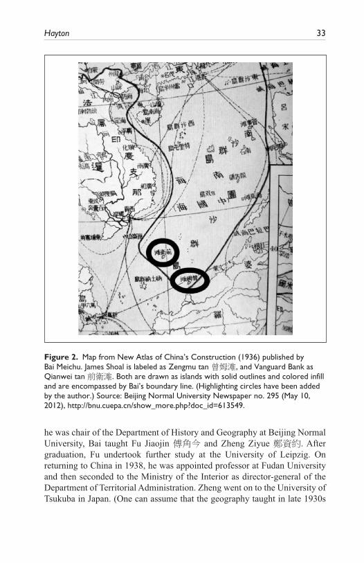
Hayton 33
he was chair of the Department of History and Geography at Beijing Normal University, Bai taught Fu Jiaojin 傅角今 and Zheng Ziyue 鄭資約. After graduation, Fu undertook further study at the University of Leipzig. On returning to China in 1938, he was appointed professor at Fudan University and then seconded to the Ministry of the Interior as director-general of the Department of Territorial Administration. Zheng went on to the University of Tsukuba in Japan. (One can assume that the geography taught in late 1930s
Figure 2. Map from New Atlas of China’s Construction (1936) published by Bai Meichu. James Shoal is labeled as Zengmu tan 曾姆滩, and Vanguard Bank as Qianwei tan 前衛滩. Both are drawn as islands with solid outlines and colored infill and are encompassed by Bai’s boundary line. (Highlighting circles have been added by the author.) Source: Beijing Normal University Newspaper no. 295 (May 10, 2012), http://bnu.cuepa.cn/show_more.php?doc_id=613549.
34 Modern China 00(0)
Germany and Japan was imbued with particularly trenchant views on ques-tions of nations and their rightful territory.) Zheng was then appointed direc-tor of geography at Northwestern University in Xi’an (Tai and Tsai, 2014). On January 12, 1946, he was also seconded to the Department of Territorial Administration. According to his son’s memoir,
The Department of Territorial Administration 方域司 of the ROC Ministry of the Interior [the government organ responsible for delimiting the country’s borders] employed Professor Zheng Ziyue as a member of a special committee in the Ministry of the Interior to participate in formulating 參與 [i.e., “delimiting,” “drawing up,” or “determining”] the national boundaries of the South China Sea islands and organizing the names of the South China Sea reefs, rocks, and sandy beaches [e.g., sand bars]. (Zheng, 2011)
In April 1946, the new ROC governor of Taiwan, Chen Yi, requested per-mission from the Executive Yuan to take over Pratas, the Paracels, and the Spratlys, arguing that they had been administered from Taiwan during the Japanese occupation period. Chen asked the government to request the assis-tance of the American authorities in the Philippines with the project. Following a request from the Executive Yuan, the Ministry of the Interior reported that Pratas and the Paracels had been administered by Guangdong province before the war and they had little information about them. According to Chen Qianping, in June 1946, “Due to a temporary failure to locate the exact posi-tion of the New Southern Islands [using the Japanese name for the Spratlys], the Foreign Ministry actively engaged the Ministry of Military Command and the Ministry of Military Administration to deliberate on the takeover of the Dongsha [Pratas] and Xisha [Paracel] Islands” (Chen: 2017: 5).
This may explain why one of the first tasks Professor Zheng undertook was to draw up a Location Sketch Map of the South China Sea Islands 南海諸島位置略圖. This was commissioned for a meeting of representatives of the Ministry of Foreign Affairs, Ministry of the Interior, Ministry of National Defense, and ROC Navy General Headquarters at the ROC Ministry of the Interior on September 25, 1946. Chris P. C. Chung has shown how this meet-ing was convened in order to “delimit the scope of what is to be received [from Japan] for the purpose of reclaiming [lit., “receiving”] each of the islands in the South China Sea” (Chung, 2016: 43). This map appears to be the very first document produced by the Chinese government to include a U-shaped line around the South China Sea. According to Tai and Tsai (2014), “it is reason-able to conclude that Fu and Zheng had drawn the U-shaped line based on the preliminary U-shaped line in ‘The Map of Chinese Domain in the South China Sea’ drawn by Mei-chu Pai [Bai Meichu]” (Tai and Tsai, 2014: 201).

Hayton 35
A few months after this meeting, Zheng accompanied the very first ROC naval mission to the islands of the South China Sea. On December 12, 1946, he was part of the landing party on Itu Aba, the largest of the Spratly Islands (Zheng, 2011). This was the very first time any Chinese official ever landed in the Spratlys. This expedition was only possible because of the recent arrival of ships and training given to the ROC by the United States. (The ROC ship Taiping, which led the expedition to the Spratlys, began life as the USS Decker—U.S. Navy, 1968.) The United States hoped the vessels would be used to fight Communist revolutionaries. Instead their first mission was to fly the national flag in the Paracels and the Spratlys. As the Communists advanced and the position of the Nationalist government looked increasingly perilous, the ROC government chose to prioritize a literal flag-waving exer-cise to shore up its nationalist legitimacy.
On February 25, 1947, the commander of the expedition to the Spratlys, Lieutenant Colonel Lin Zun, sent his report to Navy Command Headquarters. In it he argued that the Paracels were only 200 nautical miles from Hainan and that sovereignty should belong to China. He was more ambivalent about the Spratlys, however. He noted that they were more than 500 nautical miles from Hainan and only 200 nautical miles from the Philippines and thus the scope for “receiving” them should be further studied (Chen, 2016: 293).
Discussions within the ROC government continued for two months until, on April 14, 1947, the Ministry of the Interior convened a meeting with rep-resentatives from the Ministry of National Defense, the Ministry of Foreign Affairs, and the Navy Command Headquarters. According to Tai and Tsai, it
made the following resolution:
(1) The southernmost point of Chinese territory in the SCS was reaffirmed as being the James Shoal. This had become the standard adopted in the publications of Chinese government organizations, schools, and the press.
(2) It was decided that the M.O.I. should demonstrate authority over the Paracel Islands and the Spratly Islands by providing a detailed description of the islands, proclaiming Chinese sovereignty over the islands, and ensuring public awareness of China’s authority over the islands. In addition, the Navy should do its utmost to station personnel on the islands.
(3) During the fishing season in the waters surrounding the Paracel Islands and the Spratly Islands, the Navy and the government of Guangdong Province should protect the fishermen who fished near the islands and provide them with transportation and communication facilities. (Tai and Tsai, 2014: 185)

36 Modern China 00(0)
The choice of James Shoal as the southernmost point and the inclusion of Vanguard Bank were remarkable innovations. They had the effect of put-ting the Spratly Islands within the claimed Chinese territory. As we have seen, these choices rested upon two errors—the ambiguous translation of their English names and the rendering of them as islands on a privately drawn map. These errors were then incorporated into China’s official mari-time claim. In contrast to its 1943 edition which said the claim went only as far south as the Paracels, the 1947 version of the Ministry of Information’s China Handbook stated that “the southernmost . . . boundaries remain to be settled . . . and the sovereignty of the Tuansha Islands on the south are con-tested among China, the Commonwealth of Philippines and Indochina” (Ministry of Information, 1947: 1). (The Spratlys here still referred to as “Tuansha.”)
This reflected ongoing disagreements within the ROC government. Lieutenant Colonel Lin Zun continued to argue that the Spratlys should be divided between China and the newly independent Philippines. A further inter-ministerial meeting was held on June 10, 1947. According to Hurng-Yu Chen, “Director-General of the Ministry of the Interior Fu Chiao-chin . . . stated that the publications on the sovereignty of the islands in the South China Sea by Chinese institutions and schools prior to the Anti-Japanese War should serve as a guidance regarding the territorial restoration issue.” In other words, the government would be guided by putative claims made by civic organisations in the 1930s. The meeting agreed that the entire Spratly archi-pelago should be claimed but given that only Itu Aba (Taiping Dao) had been physically occupied, the claim should wait until other islands had been vis-ited. The Executive Yuan endorsed this proposal on June 14 (Chen, 2016: 297; Chen, 2017: 17–18). It is not clear what, if any, expeditions to other islands there actually were over the following months, but the ROC govern-ment continued with its work as if they had taken place regardless.
In October 1947 the ROC Ministry of the Interior renamed the islands within its new claim. Most of the 1935 translations and transliterations were replaced by new, grand-sounding and more “Chinese” titles. For example, the Chinese name for Spratly Island was changed from Si-ba-la-tuo to Nanwei 南威島 (Noble South)13 and Scarborough Shoal was changed from Si-ka-ba-luo 斯卡巴洛礁 (the transliteration) to Minzhu jiao 民主礁 (Democracy Reef). Vanguard Bank’s Chinese name was changed from Qianwei tan to Wan’an tan 萬安灘 (Ten Thousand Peace Bank). This process was repeated across the archipelagos. The ministry seems to have recognized its earlier problem with translating “shoal” at this time because it coined the word ansha 暗沙, literally “hidden sand,” as a neologism to use instead of tan 灘 in the names of several features, including James Shoal, which was renamed Zengmu
Hayton 37
ansha 曾母暗沙 (Chen, 1996: 540–49). During this renaming process the name Nansha was moved south from Macclesfield Bank to describe what would now be claimed as China’s southern islands—the Spratlys. The Macclesfield Bank was renamed Zhongsha (“central sands”). The name Tuansha disappeared from Chinese maps (Chen, 2017: 19).
In November 1947, the Department of Territorial Administration of the Ministry of the Interior published a book jointly written by Fu and Zheng, A Geographical Recording of the Islands in the South China Sea 南海諸島地理誌略, which “documented the recovery and repossession process of the islands” and included the Location Sketch Map drawn up the year before (Fu and Zheng, 1947). The following month, “the Bureau of Measurements under the Ministry of Defense printed a map called ‘The Location Map of the South China Sea Islands’ (南海諸島位置圖), which was nearly identical to the ‘Approximate Location Map of the South China Sea Islands’ but included nautical mile (nm) lines” (Tai and Tsai, 2014: 186). In February 1948 that was published as part of the Atlas of Administrative Areas of the Republic of China and the U-shaped line—with 11 dashes and an implicit claim to every feature within it—became a public state position.
Impact of the 1946 Expedition
It was not until 1948, therefore, that the Chinese state formally extended its territorial claim in the South China Sea to the Spratly Islands, as far south as James Shoal. Clearly something had changed in the years between July 1933, when the Republic of China government was unaware that the Spratly Islands existed, and April 1947, when it could “reaffirm” that the southernmost point of its territory was James Shoal. Chris P. C. Chung has examined the discus-sions within the ROC bodies concerned with the South China Sea during 1946–1947. He notes that these officials were convinced that China had asserted a claim to the Spratlys fourteen years before (Chung, 2016: 44–45). On the evidence available to us now we can see that that was not the case.
What seems to have happened is that in the chaos of the 1930s and the Second World War a new memory came to be formed in the minds of officials about what had happened in the 1930s. My hypothesis is that these individu-als confused the real protest issued by the ROC government against French activities in the Paracels in 1932 with a nonexistent protest against French activities in the Spratlys in 1933. Further confusion would have been caused by the agitation of the Southwest Political Council and the general assertion that the islands annexed by France in 1933 were indisputably Chinese. Thus, the imagined geobody conjured up by the confusion between different island groups in that crisis came to be the real territorial claim.

38 Modern China 00(0)
Conclusion
China’s maritime geobody, a collective psychological attachment to offshore islands, emerged through several stages during the early twentieth century. In early 1909 there was almost no interest in the fate of these faraway features among either officials or the general population. Forty years later, officials and agitators alike could declare them to be an intrinsic part of the national corpus. Part of this process was a consequence of imperial China’s transition into a new world of theoretically equal nation-states, but part of it was the result of decisions taken by particular elites to use the new nationalism to legitimize their political positions.
In 1909, popular anger against foreign powers was a potent destabilizing force in southern China. The sense that a Chinese nation was being collec-tively violated had become embedded among a vocal section of the popula-tion. Before the twentieth century it seems unlikely that the discovery of a Japanese merchant on an island like Pratas would have generated quite the same reaction. But in the context of political crisis, in which the nationalist legitimacy of the Qing rulers was being challenged, it is not surprising that they took steps to assert a new form of national sovereignty over Pratas.
It was less likely that they would do the same thing over the Paracel Islands. So far as anyone in China was aware, the islands were not being violated by foreigners. The decision to launch a high-profile mission to claim them was a deliberate political gesture by the local Qing administration intended to buttress a weakening state. However, after this grand patriotic gesture, the state lost interest in the islands, failing to administer them or undertake the kind of acts that Western powers regarded as the necessary building blocks of sovereignty.
It was not at all logical that Chinese officials would extend their country’s territorial claim to the Spratly Islands, far to the south and much closer to the coasts of Indochina, Borneo, and the Philippines. This only happened because of a particular set of circumstances in 1933—in particular, the mistaken per-ception that France was again violating “Chinese” territory by annexing the Spratlys. Once again nationalist sentiment was directed in particular direc-tions in order to bolster the threatened legitimacy of a ruling elite: in this case from the rival Southwest Political Council. The council mobilized nationalist arguments to criticize the government in Nanjing, forcing the latter to justify what many regarded as appeasement of imperialist aggression. It did the council little good in the long term, however: by 1936 its autonomy had been swallowed by the Nanjing government (Lary, 1974: 205). The same was true in 1947: a threatened Nationalist government tried to turn the South China Sea into a source of political legitimacy, but within two years it too had been ousted from power.
Hayton 39
In the writings reviewed here, Chinese officials and their public reveal understandings about the nature of sovereignty that differ from those of Westerners. Chinese documents published during the episodes examined here suggest a collective belief that islands off the coast and regularly visited by Chinese fishermen were naturally Chinese territory. For their own reasons, the Western powers prioritized discovery and administration over proximity. Chinese officials and writers gave almost no consideration at all to the pos-sibility that these islands may be equally near other coastlines (such as the American-occupied Philippines or French-occupied Indochina) or that other fishing communities might use them as well. These clashing claims only became evident as the geopolitical competition between China, France, and Japan increased in the 1920s and 1930s.
The sometimes-cynical process of asserting an official claim to the islands developed in parallel with the construction of an emotional claim to them—a maritime geobody. Academics, officials, and journalists adopted that emotional claim and sought to spread it by disseminating information with which their audiences could construct a sense of attachment to places that they had never, and would never, visit. This was not so much an imagined community, to use Benedict Anderson’s phrase (Anderson, 1991), as an “imagined territory”—but one that, in the future, people would be willing to die for. The construction of that imagined territory, that geobody, took place through the mobilization of particular kinds of historical evidence—snippets of information that reinforced the preexisting sense of right. This process continues to this day.
There is much more work to be done in the archives of the Land and Water Maps Review Committee and its successors and on the relationship between their work, the private initiatives of patriotic cartographers, geographers, and other educators and the journalistic and nationalistic writings of the period. Only by doing so can we fully tell the story of the emergence of China’s “his-toric claim” to the South China Sea.
Acknowledgments
The author would like to record his grateful thanks to François-Xavier Bonnet, Chris P. C. Chung, and Stephen Davies for sharing many of the resources and ideas that allowed this article to be written. He thanks the two anonymous referees for their use-ful assistance and Richard Gunde for his meticulous sub-editing. He is indebted to Li-Ning Chen and Pinnhueih Lee for their diligent translation work and the staff of the Harvard Yenching Library for help in finding original Chinese sources.
Declaration of Conflicting Interests
The author declared no potential conflicts of interest with respect to the research, authorship, and/or publication of this article.

40 Modern China 00(0)
Funding
The author received no financial support for the research, authorship, and/or publica-tion of this article.
Notes
1. Since Nan’ao county included the strategic island of Nan’ao where a naval base had been established in 1576 to combat local piracy, it is possible that Li had some experience of coastal anti-piracy operations (Po, 2016: 125).
2. Although this account appears well grounded, I have not been able to find another source to confirm it. The British consul in Haikou was Pierce Essex O’Brien Butler (1858–1954).
3. The “Englishman” was probably British officer Hamilton Foote Carey (North China Daily News, May 28, 1926: 18, “A new pilot for the Lower Yangtze”).
4. Some sources assert that this expedition took place two years earlier, in 1907. This appears to be an error that emerged when Li Zhun’s account of his voyage was reprinted in newspapers in 1933 (Li, 1933: 1). There are no reports in either the local press or other sources of an expedition in 1907. Given the size of his expedition and the importance of the officials involved, it seems unlikely that it would have passed unnoticed. All the corroborating material from contemporary newspapers and other sources states that the voyage was in 1909.
5. Worryingly, the map has been cut out and stolen from the only known copy of the atlas held by a Western institution, the University of British Columbia (author’s correspondence).
6. Original documents can be viewed online at http://catalog.digitalarchives.tw/item/00/67/07/ee.html.
7. The two texts are slightly different. 8. The author has been unable to find any corroborating evidence for this assertion,
made 50 years after the events it purports to describe. Two German ships, the SMS Freya and the SMS Iltis surveyed the Paracels at various points in 1881, 1882, 1883, and 1884 and the German navy subsequently published a map of the islands (Hancox and Prescott, 1995: 36). If any protest was issued, it does not seem to have prevented the survey (Hayton, 2017: 23).
9. This presumably refers to Li Zhun, so the year was 1909, not 1907.10. The quotation here reproduces the ellipsis in Bonnet (2012: 17) at the end of the
first paragraph, but omits Bonnet’s added emphasis on the sentence that begins “In conclusion, we have one piece of evidence . . .”
11. Another effect of the 1933 crisis was to awaken interest about the islands in the Philippines. Former senator Isabelo de los Reyes began to agitate for the American colonial authorities to annex the Spratlys in 1933, and in 1937 Secretary of the Interior Epidio Quirino officially filed a claim with the United States (Bonnet, 2004: 18–20).
12. As we shall see, many of these names were revised by the ROC government in 1947 to make them sound more Chinese. Spratly became Nanwei (Noble South) and Luconia became Kang 康, which means “health” but was derived from Lu-kang-ni-ya.

Hayton 41
13. The list notes that the name commemorates the governor of Guangdong prov-ince, Luo Zhuoying 羅卓英, also known as Ci Wei 慈威. I am grateful to Tiff Lin for this information (ROC Ministry of the Interior, 1947: 7).
References
ANDERSON, BENEDICT (1991) Imagined Communities: Reflections on the Origin and Spread of Nationalism. London: Verso.
BONNET, FRANÇOIS-XAVIER (2004) “The Spratlys: a past revisited.” World Bulletin, Manila: Univ. of the Philippines Institute of International Legal Studies 23 (July–Dec.): 13–27.
BONNET, FRANÇOIS-XAVIER (2012) “Geopolitics of Scarborough Shoal.” Discussion paper 14. Bangkok: Institut de recherche sur l’Asie du Sud-Est con-temporaine (IRASEC).
BOYLE, JOHN HUNTER (1972) China and Japan at War, 1937–1945: The Politics of Collaboration. Stanford, CA: Stanford Univ. Press.
CALLAHAN, WILLIAM A. (2009) “The cartography of national humiliation and the emergence of China’s geobody.” Public Culture 21, 1: 141–73.
CALLAHAN, WILLIAM A. (2012) China: The Pessoptimist Nation. Oxford: Oxford Univ. Press.
CHEMILLIER-GENDREAU, MONIQUE (2000) Sovereignty over the Paracel and Spratly Islands. The Hague: Kluwer Law International.
CHEN HSIN-CHIH (2001) “La Réponse chinoise a l’occupation française des Îles Spratly en 1933.” Guerres mondiales et conflits contemporains 199 (July): 5–24.
CHEN HURNG-YU (2016) “Republic of China’s decision-making process in regards to drawing a U-shaped line on the map of the South China Sea and its implica-tions.” Pacific Focus 31, 2 (Aug.): 283–306.
CHEN, LESLIE H. DINGYAN (1999) Chen Jiongming and the Federalist Movement: Regional Leadership and Nation Building in Early Republican China. Ann Arbor: Center for Chinese Studies, Univ. of Michigan.
CHEN, QIANPING (2017) “The Nationalist government’s efforts to recover Chinese sovereignty over the islands in the South China Sea after the end of World War Two.” J. of Modern Chinese History. doi:10.1080/17535654.2017.1313527.
CHEN TIANXI 陳天錫 (1928) 西沙島東沙島成案彙編 (A compilation of materials concerning the Xisha and Dongsha Islands case). Guangzhou: Guangdong shiyeting.
CHENG, TAO (1975) “Dispute over the South China Sea islands.” Texas Int. Law J. 10, 2: 265–77.
Chinese Biographical Database (2010) “Chen Tianxi.” http://www.berkshirepublish-ing.com/chinesebiodb/BioView.aspx?id=2204 (accessed Aug. 14, 2017).
CHIU, HUNGDAH and CHOON-HO PARK (1975) “Legal status of the Paracel and Spratly Islands.” Ocean Development & Int. Law 3, 1: 1–28.
CHUNG, CHRIS P. C. (2016) “Drawing the U-shaped line: China’s claim in the South China Sea, 1946–1974.” Modern China 42, 1 (Jan.): 38–72
COLLINGWOOD, CUTHBERT (1867) “The natural history of Pratas Island.” Pp. 145–52 in James Samuelson and William Crookes (eds.), Q. J. of Science 4, 13. London: John Churchill and Sons.

42 Modern China 00(0)
CULP, ROBERT (2007) Articulating Citizenship: Civic Education and Student Politics in Southeastern China, 1912–1940. Cambridge, MA: Harvard Univ. Asia Center.
DAVIES, STEPHEN, with KENNETH KWAN-KIN WONG (2006) “Swords become station-pointers: the charting of the China coast 1841–1930.” Pp. 79–613 in Proceedings of the International Conference on the History and Culture of the British Concessions in China during the Late Qing Dynasty, held in Weihai, Oct. 20–22, 2006, Organizing Committee of ICHCBC.
DIRLIK, ARIF (1997) “Narrativizing revolution: the Guangzhou Uprising (11–13 December 1927) in workers’ perspective.” Modern China 23, 4 (Oct.): 363–97.
Edward Stanford Ltd. (1918) Asiatic Archipelago. Map. British Library shelfmark Maps 88715.(13).
FU JIAOJIN 傅角今 and ZHENG ZIYUE 鄭資約 [eds.] (1947) 南海諸島地理誌略 (Geographical recording of the islands in the South China Sea). Shanghai: Commercial Press.
GRANADOS, ULISES (2005) “As China meets the Southern Sea frontier: ocean identity in the making, 1902–1937.” Pacific Affairs 78, 3: 443–61.
GRANADOS, ULISES (2006) “Chinese ocean policies towards the South China Sea in a transitional period, 1946–1952.” China Rev. 6, 1 (Spring): 153–81.
GRANADOS, ULISES (2008) “Japanese expansion into the South China Sea: coloni-zation and conflict, 1902–1939.” J. of Asian History 42, 2: 117–42
GUNN, GEOFFREY (1991) “Anglo-French rivalry over the Spratlys (1930–1937): an aspect of world historical incorporation.” Pp. 262–82 in R. D. Hill, Norman G. Owen, and E. V. Roberts (eds.), Fishing in Troubled Waters. Hong Kong: Centre of Asian Studies, Univ. of Hong Kong.
HAN ZHENHUA 韓振華 [ed.] (1988) 我國南海諸島史料彙編 (A compilation of historical sources on our country’s Southern Sea islands). Beijing: Dongfang chubanshe.
HANCOX, D. J. and JOHN PRESCOTT (1995) “A geographical description of the Spratly Islands and an account of hydrographic surveys amongst those islands.” Maritime Briefing 1, 6. Durham, UK: International Boundaries Research Unit, Univ. of Durham.
HAYTON, BILL (2017) “When good lawyers write bad history.” Ocean Development & Int. Law 48, 1: 1–18.
HEINZIG, DIETER (1976) Disputed islands in the South China Sea: Paracels, Spratlys, Pratas, Macclesfield Bank. Hamburg: Institut für Asienkunde.
Hongkong General Chamber of Commerce (1923) Report of the General Committee of the Hongkong General Chamber of Commerce.
HU HUANYONG 胡焕庸 (1934) “法日凱覦之南海諸島” (The Southern Sea islands coveted by France and Japan). 外交評論 3, 5: 65–72.
LARY, DIANA (1974) Region and Nation: The Kwangsi Clique in Chinese Politics 1925–1937. Cambridge: Cambridge Univ. Press.
LI JINMING and LI DEXIA (2003) “The dotted line on the Chinese map of the South China Sea: a note.” Ocean Development & Int. Law 34, 3–4: 287–95.
Hayton 43
LI ZHUN李準 (1933) “李準巡海記” (On Li Zhun’s patrol of the sea).” 國聞周報 10, 33 (Aug.): 1–8.
MAHER, CAPTAIN THOMAS (1937) USC&GS Manila, Memorandum to Mr. Wayne Coy, Office of the U.S. High Commissioner, Dec. 10, 1937. Bureau of Insular Affairs (BIA) 907.127 NARA. Quoted in Bonnet, 2012: 16.
Ministry of Foreign Affairs (1933) 外交部公報 (Gazette of the Ministry of Foreign Affairs) 6, 3 (July–Sept.): 206–23.
Ministry of Foreign Affairs (1995) 外交部南海諸島檔案彙編 (Compilation of archives of the South China Sea islands of the Ministry of Foreign Affairs). Taipei.
Ministry of Information (1943) China Handbook 1937–43. Calcutta: July 1943 (British Library shelfmark BLL01000687158), and New York: Macmillan, Nov. 1943 (British Library shelfmark BLL01000687157)
Ministry of Information (1947) China Handbook 1937–1945. Revised and Enlarged with 1946 Supplement. A Comprehensive Survey of Major Developments in China in Eight Years of War. New York: Macmillan.
Ministry of the Interior (1947) 內政部公布: 南海諸島新舊名稱對照表 (Ministry of Interior announcement: table comparing the new and old names of the islands of the South China Sea),Oct. N.p.: 內政部方域司印.
MURRAY, DIAN (2004) “Piracy and China’s maritime transition, 1750–1850.” Pp. 43–60 in Wang Gungwu and Ng Chin-keong (eds.), Maritime China in Transition, 1750–1850. Wiesbaden: Harrassowitz Verlag.
PO, RONALD C. (2016) “Mapping maritime power and control: a study of the late eighteenth century ‘Qisheng yanhai tu’ (A coastal map of the seven provinces).” Late Imperial China 37, 2 (Dec.): 93–136.
RHOADS, EDWARD J. M. (1975) China’s Republican Revolution: The Case of Kwangtung, 1895–1913. Cambridge, MA: Harvard Univ. Press.
ROBERTS, QUINCY F. (1933) American consul, Saigon. “French annexation of certain isolated islands near the Philippine Islands.” U.S. Department of State archives GRC 851.014/65, Sept. 20.
SALMON, CLAUDINE (2006) “Coastal maps from the beginning of the Qing dynasty, with special reference to the Qingchu haijiang tushuo.” Pp. 177–90 in Angela Schottenhammer and Roderich Ptak (eds.), The Perception of Maritime Space in Traditional Chinese Sources. Wiesbaden: Otto Harrassowitz Verlag.
SAMUELS, MARWYN S. (1982) Contest for the South China Sea. New York: Methuen.
SASGES, GERARD (2016) “Absent maps, marine science, and the re-imagination of the South China Sea, 1922–1939.” J. of Asian Studies 75, 1 (Feb.): 157–80.
STUART-FOX, MARTIN (2003) A Short History of China and Southeast Asia: Tribute, Trade and Influence. London: Allen & Unwin.
SVARVERUD, RUNE (2007) International Law as World Order in Late Imperial China: Translation, Reception and Discourse, 1847–1911. Leiden: Brill.
Times (1907) “The Japanese & Pratas Island.” Sept. 9, p. 7.TØNNESSON, STEIN (2006) “The South China Sea in the age of European decline.”
Modern Asian Studies 40, 1: 1–57.

44 Modern China 00(0)
TSUNG-HAN TAI and CHI-TING TSAI(2014) “The legal status of the U-shaped line revisited from the perspective of inter-temporal law.” Pp. 177–208 in Szu-shen Ho and Kuan-Hsiung Wang (eds.), A Bridge over Troubled Waters: Prospects for Peace in the South and East China Seas. Taipei: Prospect Foundation.
United Kingdom Hydrographic Office (1906) The China Sea Directory, 5th ed. London: Printed for the Hydrographic Office, Admiralty, by Eyre and Spottiswoode, printers to the King’s Most Excellent Majesty.
U.S. Dept. of State, Division of Far Eastern Affairs (1933) Memorandum to the American minister at Peiping. Aug. 18.
U.S. Navy (1968) Dictionary of American Naval Fighting Ships, Volume 2. Washington DC, 1963 reprint with corrections.
VAN DE VEN, HANS (2014) Breaking with the Past: The Maritime Customs Service and the Global Origins of Modernity in China. New York: Columbia Univ. Press.
WINICHAKUL, THONGCHAI (1994) Siam Mapped: A History of the Geo-body of a Nation. Honolulu: Univ. of Hawaii Press.
WONG, SIN-KIONG (1993) “The Tatsu Maru incident and the anti-Japanese boycott of 1908: a study of conflicting interpretations.” Chinese Culture 34, 3 (Sept.): 77–92.
WU FENG-MING (2011) “On the new geographic perspectives and sentiment of high moral character of geographer Bai Meichu in modern China.” Geographical Research 30, 11: 2109–14. http://www.dlyj.ac.cn/EN/10.11821/yj2011110018.
XIN YEJIANG 辛業江 [gen. ed.] (1996) 中國南海諸島 (China’s southern sea islands). Haikou: Hainan guoji xinwen chuban zhongxin.
ZHENG FANGJIAN 鄭仿健 (2011) “永遠的南中國海——懷念父親鄭資約教授” (Forever South China Sea: remembering my father, Professor Zheng Ziyue). Chinese Univ. of Hong Kong, China Research Centre. http://mjlsh.usc.cuhk.edu.hk/book.aspx?cid=6&tid=536&pid=3453 (accessed Aug. 14, 2017).
ZOU KEYUAN (1999) “The Chinese traditional maritime boundary line in the South China Sea and its legal consequences for the resolution of the dispute over the Spratly Islands.” Int. J. of Marine and Coastal Law 14, 1 (Mar.): 27–55.
ZOU KEYUAN (2007) “South China Sea studies in China: achievements, constraints and prospects.” Singapore Year Book of Int. Law 11: 85–98.
Author Biography
Bill Hayton is an Associate Fellow with the Asia-Pacific Programme at Chatham House, the Royal Institute of International Affairs, London.