the management of soil erosion consortium project :...
TRANSCRIPT
The Management of Soil Erosion Consortium Project:A Case of Integrated Natural Resource Management
Research
AR. Maglinao', C. Yaleniin' and F. Penning de Vries3
Abstract
The research project, funded by the Asian Development Bank, was conducted by acollaborative team under the Management ofSoil Erosion Consortium (MSEC) in selectedcatchments in Indonesia, Lao PDR, Nepal, Philippines, Thailand, and Vietnam. In general,the catchments represent a resource management domain with biophysical and socioeconomic characteristics common to the marginal sloping uplands. The participatory processhas been employed since the establishment of the consortium. Consultation meetings anddialogues among various stakeholders including the NARES, IARCs, ARls, NGOs, donorsand farmers were undertaken to design the research program and its implementation. Anetwork of 34 catchments and sub-catchments equipped for hydrology and soil erosionmanagement research was established and now serves as a facility for conducting researchon integrated land and water management. The research yielded outputs such as researchmethodology, tools, and guidelines to support decision-making and improvedimplementation. These include a decision support system (DSS) and soil erosion andhydrological models to simulate erosion and runoff under different scenarios. Dialogueswith farmers identified variants of the hedgerow cropping technology combined with otheroptions considered to generate additional income more quickly as potentially sustainableland management options. Originally designed as a longer-term project (/2 years), IWMIhas proposed a second phase to develop, adapt, and disseminate appropriate tools andmethodologies to scale up the application of research results and technology options tolarger catchments. This will better capture the interactions among the on- and off-site usersof land and water resources, and more effectively resolve the competing demands of theseusers.
Introduction
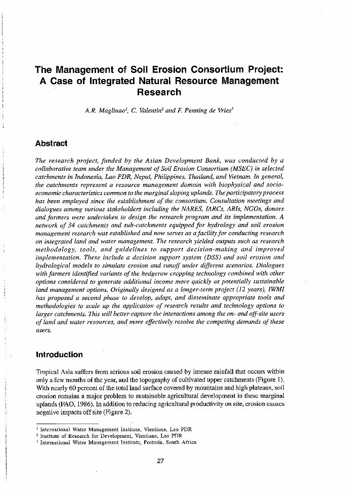
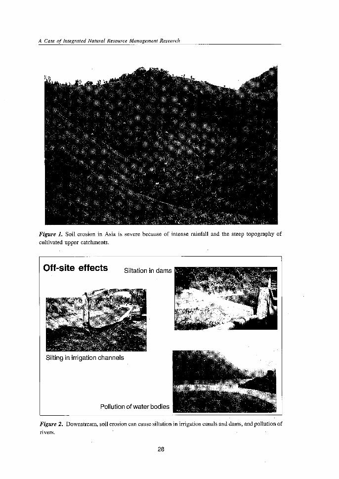
Tropical Asia suffers from serious soil erosion caused by intense rainfall that occurs withinonly a few months of the year, and the topography of cultivated upper catchments (Figure 1).With nearly 60 percent of the total land surface covered by mountains and high plateaus, soilerosion remains a major problem to sustainable agricultural development in these marginaluplands (FAO, 1986). Inaddition to reducing agricultural productivity on site, erosion causesnegative impacts off site (Figure 2).
1 International Water Management Institute, Vientiane, Lao PDR2 Institute of Research for Development, Vientiane, Lao PDR3 International Water Management Institute, Pretoria, South Africa
27
A Case of Integrated Natural Resource Management Research
Figure 1. Soil erosion in Asia is severe because of intense rainfall and the steep topography ofcultivated upper catchments.
Pollution of water bodies
Off-site effects
Silting in irrigation channels
Siltation in dams
Figure 2. Downstream, soil erosion can cause siltation in irrigation canals and dams, and pollution ofrivers.
28
A.R. Maglinao, C. Valentin and F. Penning de Vries
The challenge is to recognize that land degradation, including soil erosion, is drivenlargely by socio-economic factors. Research on "oil erosion has largely ignored the endusers, or has been based on small plot experiments of no relevance to the watershed situation.A new paradigm for research is required which ensures that the whole range of stakeholders,from land users to policy-makers is involved in the generation and promotion of improvedland use practices (Greenland et al., 1994). InAustralia, Europe, and North America, integratedcatchment management has been adopted widely as the most effective way to involvestakeholders, and to utilize scientific knowledge in the management of land and water resources.However, there is still a strong need for capacity development of the NARES, especially inAsia, who will be involved in this kind of research. This has led to the establishment of theManagement of Soil Erosion Consortium (MSEC), which is one of four consortia in the soil,water and nutrient management (SWNM) system-wide initiative of the CGIAR
In late 1998, MSEC initiated a research project on soil erosion management in sevencountries in Asia, namely, Indonesia,Laos, Nepal, Philippines,SriLanka, Thailand, and Vietnamwith financial support from the Asian Development Bank (ADB). However, Sri Lanka wasunable to continue its participation because of some organizational problems.
The project, "Catchment Approach to Managing Soil Erosion in Asia" (ADB-RETA5803) was executed by the International Board for Soil Research and Management (IBSRAM)until March 2001 when the International Water Management Institute (IWMI) established aregional office in Bangkok, Thailand and consequently served as the Executing Agency. TheTechnical Assistance Agreement was signed on 17 September 1998 and the project wasimplemented for four years until 31 December 2002.
This report presents the accomplishments of the project during its first four years ofimplementation in six countries in Asia, namely, Indonesia, Laos, Nepal, Philippines, Thailand,and Vietnam. It highlights the research outputs as they relate to integrated natural resourcemanagement. It also summarizes its accomplishments in the other components of informationdissemination and capacity building vis if vis the outputs expected. The project's strategy ingovernance and management is likewise presented.
Project Objectives and Expected Outputs
The project aimed to develop and promote sustainable and socially acceptable communitybased land management options for sloping uplands through a participatory andinterdisciplinary approach at a catchment level. The specific objectives are:
1. Develop sustainable and. acceptable community-based land management optionswithin a catchment framework;
2. Quantify and evaluate the biophysical, environmental, and socio-economic on- andoff-site impacts of soil erosion;
3. Generate reliable information and scientifically-based guidelines to improvecatchment management policies;
4. Enhance the capacity of NARES on integrated catchment management and soilerosion control.
The objectives have been set to address important issues as perceived by the majorstakeholders, and the design process was carried out with their active involvement.
The project focused on three major components to address the stated objectives. Theseare:
29
A Case of Integrated Natural Resource Management Research
Catchment research to evaluate the effects of different land management practiceson water and nutrient flows in selected representative catchments;
• Capacity building of participating NARES in research on integrated catchmentmanagement and soil erosion; and
• Dissemination of research results for enhanced adoption of land managementtechnologies and for more accessible information as a concrete basis for decisionmaking.
The outputs from the project as indicated in the logical framework are summarized asfollows:
• Decision support tools and guidelines based on a better understanding of the onand off-site effects of soil erosion. This includes methodology for assessment ofimpacts and obtaining the participation of farmers and other stakeholders in themanagement of catchments which includes policies that will improve the managementof catchments by the local government and the communities;Alternative technologies and land management systems that are socially andinstitutionally acceptable to the communities in the catchment areas;
• Information and communication strategies to effectively disseminate the results ofthe research to the farmers and other land users;Enhanced NARES capacity in integrated catchment management research throughtraining and provision of research facilities; and
• Improved program management for catchment management research.
Project lmplementatlon
The International Water Management Institute (IWMI) serves as the Executing Agency ofthe project. The key partners in the conduct of the study are the NARES of the six participatingcountries and IRD with the active participation of the farmers in the benchmark catchments.The collaborative team works under the Management of Soil Erosion Consortium (MSEC).MSEC is one of the four consortia established through the soil, water, and nutrient management(SWNM) initiative of the CGIAR, and employs an integrated, interdisciplinary, participatory,and' community-based approach that involves all land users and stakeholders at a catchmentscale. It focuses on the on- and off-site impacts of soil erosion and integrates biophysical andsocioeconomic sciences to generate hard data and identify practical solutions that areacceptable to the various users. The following are the direct participants in the case study.
1. Centre for Soil andAgroclimate Research and Development (CSAR), Bogor, Indonesia2. Soil Survey and Land Classification Centre (SSLCC), Vientiane, Lao PDR3. Nepal Agricultural Research Council (NARC), Kathmandu, Nepal4. Philippine Council for Agriculture, Forestry and Natural Resources Research and
Development (PCARRD), Los Bafios, Laguna, Philippines5. Royal Forest Department (RFD), Bangkok, Thailand6. National Institute for Soils and Fertilizers (NISF), Hanoi, Vietnam7. Institute of Research for Development (IRD), France8. Participating farmersOther consortium partners are ICRISAT in India, ICRAF in Bogor, Indonesia, AIT in
Thailand, SEARCA in Philippines, University of Bayreuth in Germany, ADB in Philippines andCRIDA in India.
30
A.R. Maglinao, C. Valentin and F. Penning de Vries
INRM Approaches
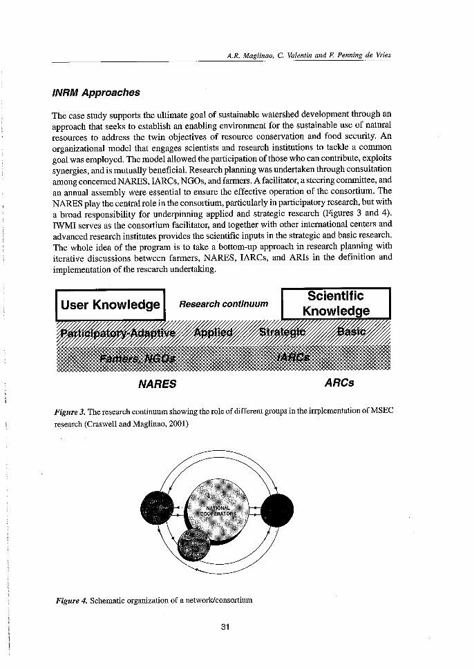
The case study supports the ultimate goal of sustainable watershed development through anapproach that seeks to establish an enabling environment for the sustainable use of naturalresources to address the twin objectives of resource conservation and food security. Anorganizational model that engages scientists and research institutions to tackle a commongoal was employed. The model allowed the participation of those who can contribute, exploitssynergies, and is mutually beneficial. Research planning was undertaken through consultationamong concerned NARES, IARCs, NGOs, and farmers. A facilitator, a steering committee, andan annual assembly were essential to ensure the effective operation of the consortium. TheNARES play the central role in the consortium, particularly in participatory research, but witha broad responsibility for underpinning applied and strategic research (Figures 3 and 4).IWMI serves as the consortium facilitator, and together with other international centers andadvanced research institutes provides the scientific inputs in the strategic and basic research.The whole idea of the program is to take a bottom-up approach in research planning withiterative discussions between farmers, NARES, IARCs, and ARls in the definition andimplementation of the research undertaking.
User Knowledge
NARES
Research continuumScientific
Knowledge~~
~~
ARCs
Figure 3. The research continuum showing the role of different groups in the irrplementation of MSEC
research (Craswell and Maglinao, 2001)
Figure 4. Schematic organization of a network/consortium
31
A Case of Integrated Natural Resource Management Research
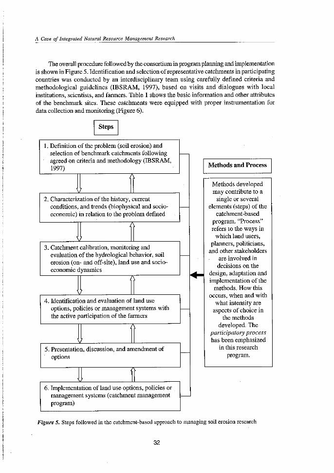
The overall procedure followed by the consortium in program planning and implementationis shown in Figure 5. Identification and selection of representative catchments in participatingcountries was conducted by an interdisciplinary team using carefully defined criteria andmethodological guidelines (IBSRAM, 1997), based on visits and dialogues with localinstitutions, scientists, and farmers. Table 1 shows the basic information and other attributesof the benchmark sites. These catchments were equipped with proper instrumentation fordata collection and monitoring (Figure 6).
I Steps I
1. Definition of the problem (soil erosion) andselection of benchmark catchments following f--
agreed on criteria and methodology (IBSRAM,
IMethods and Process I1997)
Methods developedmay contribute to a
2. Characterization of the history, current single or severalconditions, and trends (biophysical and socio- f-- elements (steps) of theeconomic) in relation to the problem defined catchment-based
program. "Process"refers to the ways in
~ which land users,
3. Catchment calibration, monitoring andplanners, politicians,
and other stakeholdersevaluation of the hydrological behavior, soil - are involved inerosion (on- and off-site), land use and socio-
decisions on theeconomic dynamics
~ design, adaptation andimplementation of the
methods. How this
4. Identification and evaluation of land useoccurs, when and with
what intensity areoptions, policies or management systems with f-- aspects of choice inthe active participation of the farmers the methods
developed. Theparticipatory processhas been emphasized
5. Presentation, discussion, and amendment of in this researchf--
options program.
J I6. Implementation of land use options, policies or
management systems (catchment management -program)
Figure 5. Steps followed in the catchment-based approach to managing soil erosion research
32
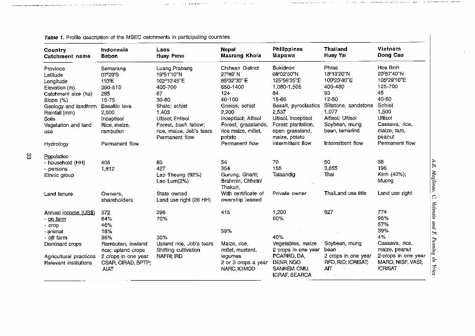
Table 1. Profile description of the MSEC catchments in participating countries
Country Indonesia Laos Nepal Philippines Thailand VietnamCatchment name Babon Huay Pano Masrang Khola Mapawa Huay Yai Oong Cao
Province Semarang luang Prabang Chitwan District Bukidnon Phrae Hoa Binhlatitude 07°20'S 19°51'10"N 27°49' N 08°02'50"N 18°13'20"N 20057'40"N
longitude 1100E 102°1 0'45"E 85°32'30" E 125°56'35"E 100°23'40"E 105°29'1O"EElevation (m) 390-510 400-700 650-1400 1,080-1,505 400-480 125-700Catchment size (ha) 285 67 124 84 93 45Slope (%) 15-75 30-80 40-100 15-60 12-50 40-60Geology and landform Basaltic lava Shale; schist Gneiss; schist Basalt, pyroclastics Siltstone, sandstone SchistRainfall (mm) 2,500 1,403 2,200 2,537 1,077 1,500Soils Inceptisol Ultisol; Entisol Inceptisol; Alfisol Ultisol, Inceptisol Alfisol; Ultisol UltisolVegetation and land Rice, maize, Forest, bush fallow; Forest, grasslands, Forest plantation, Soybean, mung Cassava, rice,use rambutan rice, maize, Job's tears rice maize, millet, open grassland, bean, tamarind maize, taro,
Permanent flow potato maize, potato peanutHydrology Permanent flow Permanent flow Intermittent flow Intermittent flow Permanent flow
U) PopulationU)
- household (HH) 405 80 54 70 50 38 ;...
- persons 1,812 427 354 155 3,655 196 ~
Ethnic group lao Theung (92%) Gurung; Gharti; Talaandig Thai Kinh (40%); ~lao lum(2%) Brahmin, Chhetri/ Muong oc
~Thakuri, .,land tenure Owners, State owned With certificate of Private owner Thailand use title land use right .'"
shareholders land use right (28 HH) owership leased 0~
Annual income (US$) 372 296 415 1,200 627 774 ";:- on farm 64% 70% 60% 96% S·- crop 46% 57%
.,;:
- animal 18% 59% 39% l'l.
~- off farm 36% 30% 40% 4% '1:lDominant crops Rambutan, lowland Upland rice, Job's tears Maize, rice, Vegetables, maize Soybean, mung Cassava, rice, '";:
rice; upland crops Shifting cultivation millet, mustard, 2 crops in one year bean maize, peanut;:So
Agricultural practices 2 crops in one year NAFRI;IRD legumes PCARRD,DA, 2 crops in one year 2-crops in one year ""Relevant institutions CSAR, CIRAD,BPTP; 2 or 3 crops a year DENR,NGO RFD,RID;ICRISAT; MARD, NISF,VASI; ~
AIAT NARC,ICIMOD SANREM,CMU, AIT ICRISAT :$;;;0ICRAF,SEARCA "
A Case of Integrated Natural Resource Management Research
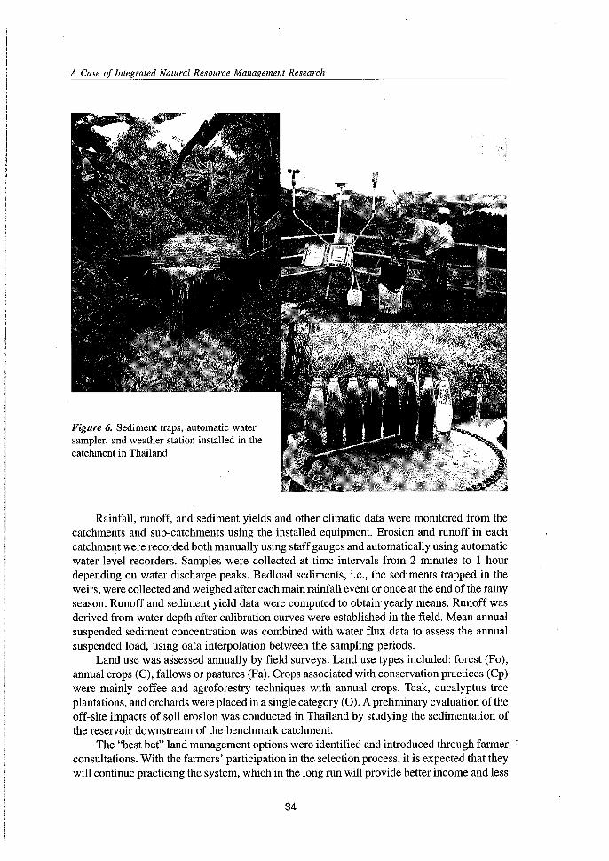
Figure 6. Sediment traps, automatic watersampler, and weather station installed in thecatchment in Thailand
Rainfall, runoff, and sediment yields and other climatic data were monitored from thecatchments and sub-catchments using the installed equipment. Erosion and runoff in eachcatchment were recorded both manually using staff gauges and automatically using automaticwater level recorders. Samples were collected at time intervals from 2 minutes to 1 hourdepending on water discharge peaks. Bedload sediments, i.e., the sediments trapped in theweirs, were collected and weighed after each main rainfall event or once at the end of the rainyseason. Runoff and sediment yield data were computed to obtain yearly means. Runoff wasderived from water depth after calibration curves were established in the field. Mean annualsuspended sediment concentration was combined with water flux data to assess the annualsuspended load, using data interpolation between the sampling periods.
Land use was assessed annually by field surveys. Land use types included: forest (Fo),annual crops (C), fallows or pastures (Fa). Crops associated with conservation practices (Cp)were mainly coffee and agroforestry techniques with annual crops. Teak, eucalyptus treeplantations, and orchards were placed in a single category (0). A preliminary evaluation of theoff-site impacts of soil erosion was conducted in Thailand by studying the sedimentation ofthe reservoir downstream of the benchmark catchment.
The "best bet" land management options were identified and introduced through farmerconsultations. With the farmers' participation in the selection process, it is expected that theywill continue practicing the system, which in the long run will provide better income and less
34
A.R. Maglinao, C. Valentin and F. Penning de Vries
resource degradation. The introduced land management options are evaluated for theiracceptability and sustainability, and a wider uptake at the community level is promoted toproduce greater impact.
The participatory process in soil erosion management research on a catchment scalewas employed since the establishment of the consortium and the design of the researchl?rogram. A series of consultation meetings and dialogues among various stakeholders,including the NARES, IARCs, ARIs, NGOs, donors and farmer representatives, was undertakento agree on the design of the research and the various partners that would be involved.
With the aim of promoting activities based on the principles of participation,interdisciplinarity, and collaboration, the NARES identified local institutions and project teamscomposed of researchers of different disciplines. Within the countries, collaboration amongrelevant partners has evolved. The organization of these teams from different institutions and
. disciplines has enhanced the participatory, interdisciplinary, and interinstitutional mechanismsthat the consortium advocates. Generally, this arrangement is committed through formalagreements signed between and among institutions. It is intended that this arrangementshould optimize the use of scarce resources and enhance the synergy of different experts andinstitutions.
Research Results
Relationships between Environmental Factors and Soil Erosion
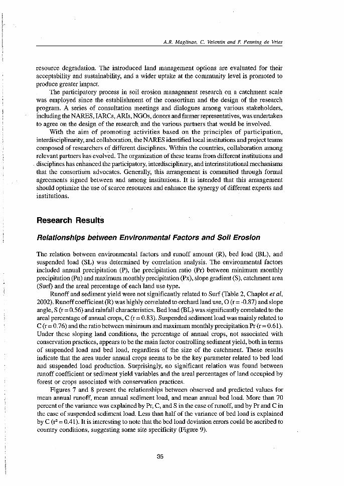
The relation between environmental factors and runoff amount (R), bed load (BL), andsuspended load (SL) was determined by correlation analysis. The environmental factorsincluded annual precipitation (P), the precipitation ratio (Pr) between minimum monthlyprecipitation (Pn) and maximum monthly precipitation (Px), slope gradient (S), catchment area(Surf) and the areal percentage of each land use type.
Runoff and sediment yield were not significantly related to Surf (Table 2, Chaplot et al,2002). Runoff coefficient (R) was highly correlated to orchard land use, 0 (r = -0.87) and slopeangle, S (r = 0.56) and rainfall characteristics. Bed load (BL) was significantly correlated to theareal percentage of annual crops, C (r = 0.83). Suspended sediment load was mainly related toC (r =0.76) and the ratio between minimum and maximum monthly precipitation Pr (r =0.61).Under these sloping land conditions, the percentage of annual crops, not associated withconservation practices, appears to be the main factor controlling sediment yield, both in termsof suspended load and bed load, regardless of the size of the catchment. These resultsindicate that the area under annual crops seems to be the key parameter related to bed loadand suspended load production. Surprisingly, no significant relation was found betweenrunoff coefficient or sediment yield variables and the areal percentages of land occupied byforest or crops associated with conservation practices.
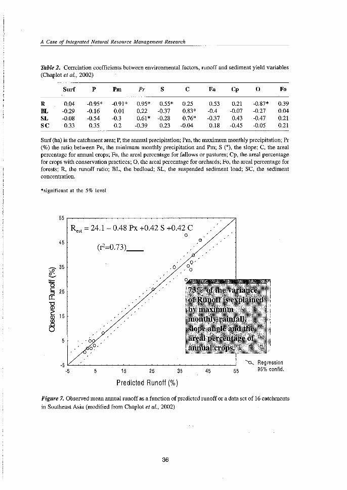
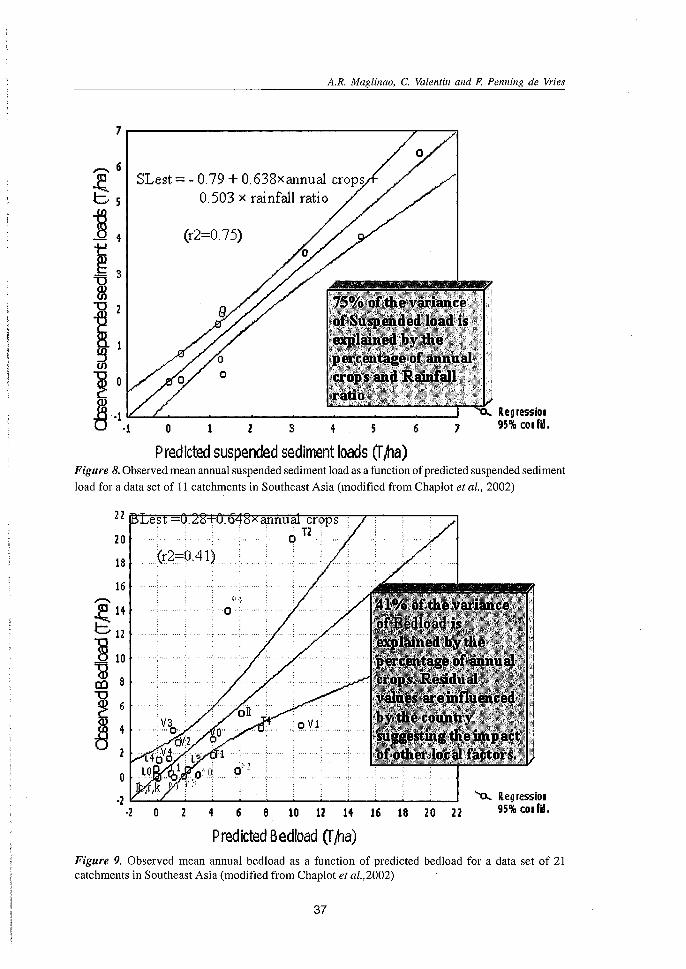
Figures 7 and 8 present the relationships between observed and predicted values formean annual runoff, mean annual sediment load, and mean annual bed load. More than 70percent of the variance was explained by Pr, C, and S in the case of runoff, and by Pr and C inthe case of suspended sediment load. Less than half of the variance of bed load is explainedby C (r2 = 0.41). It is interesting to note that the bed load deviation errors could be ascribed tocountry conditions, suggesting some site specificity (Figure 9).
35
A Case of Integrated Natural Resource Management Research
Table2. Correlation coefficients between environmental factors, runoff and sediment yield variables(Chaplot et al., 2002)
Surf P Pm Pr S C Fa Cp 0 Fo
R 0.04 -0.95* -0.91* 0.95* 0.55* 0.25 0.53 0.21 -0.87* 0.39BL -0.29 -0.16 0.01 0.22 -0.37 0.83* -0.4 -0.07 -0.27 0.04SL -0.08 -0.54 -0.3 0.61* -0.28 0.76* -0.37 0.43 -0.47 0.21SC 0.33 0.35 0.2 -0.39 0.23 -0.04 0.18 -0.45 -0.05 0.21
Surf (ha) is the catchment area; P, the annual precipitation; Pm, the maximum monthly precipitation; Pr(%) the ratio. between Pn, the minimum monthly precipitation and Pm; S (0), the slope; C, the arealpercentage for annual crops; Fa, the areal percentage for fallows or pastures; Cp, the areal percentagefor crops with conservation practices; 0, the areal percentage for orchards; Fo, the areal percentage forforests; R, the runoff ratio; BL, the bedload; SL, the suspended sediment load; SC, the sedimentconcentration.
*significant at the 5% level
Rest =24.1 - 0.48 Px +0.42 S +0.42 Co
45 G
""0' 35~........15c 25:::Jer:
~ 15
~5 '0
o~·
-5-5 5 15 25
.0
35
Q'o
, 0
45 55Regression95% confid.
Predicted Runoff (%)
Figure 7. Observed mean annual runoff as a function of predicted runoff or a data set of 16 catchments
in Southeast Asia (modified from Chaplot et al., 2002)
36
A.R. Maglinao, C. Valentin and F. Penning de Vries
7.--------------------.,.--""JI
Regressiol95% COl fil,76543
(r2=0.75)
o
SLest = - 0.79 + 0.638xannual crops0.503 x rainfall ratio
--.. 6
~5~4i 3
~"02
ll:.,u:.--4~-----------~-------I
Predicted suspended sediment loads (rfrta)Figure 8. Observed mean annual suspended sediment load as a function of predicted suspended sediment
load for a data set of II catchments in Southeast Asia (modified from Chaplot et al., 2002)
',,"0':'
'"0... Reg resslet4 6 8 101214 16 182022 95%colfil.
o·2 "----"''---'--"'''----'----~-~~-~-"''----....I
·2 0
22
20
18
16--.. H~14 O'
C12
""§ 10
aJ 8Cl)
~ 6(l)
4tj2
Predicted Bedload er/na)Figure 9. Observed mean annual bedload as a function of predicted bedload for a data set of 21catchments in Southeast Asia (modified from Chaplot et al.,2002)
37
A Case of Integrated Natural Resource Management Research
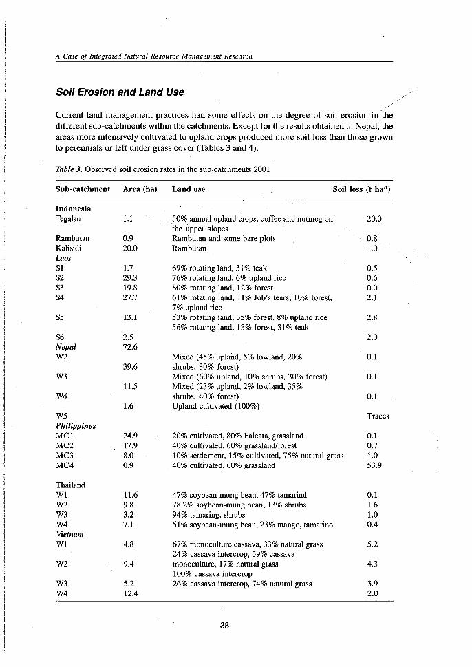
Soil Erosion and Land Use
.>Current land management practices had some effects on the degree of soil erosion in thedifferent sub-catchments within the catchments. Except for the results obtained in Nepal, theareas more intensively cultivated to upland crops produced more soil loss than those grownto perennials or left under grass cover (Tables 3 and 4).
Table 3. Observed soil erosion rates in the sub-catchments 2001
Sub-catchment Area (ha) Land use Soil loss (t ha:')
IndonesiaTegalan 1.1 ?O% annual upland crops, coffee and nutmeg on 20.0
the upper slopesRambutan 0.9 Rambutan and some bare plots 0.&Kalisidi 20.0 Rambutan 1.0LaosSI 1.7 69% rotating land, 31% teak 0.5S2 29.3 76% rotating land, 6% upland rice 0.6S3 19.8 80% rotating land, 12% forest 0.0S4 27.7 61% rotating land, 11% Job's tears, 10% forest, 2.1
7% upland riceS5 13.1 53% rotating land, 35% forest, 8% upland rice 2.8
56% rotating land, 13% forest, 31% teakS6 2.5 2.0Nepal 72.6W2 Mixed (45% upland, 5% lowland, 20% 0.1
39.6 shrubs, 30% forest)W3 Mixed (60% upland, 10% shrubs, 30% forest) 0.1
11.5 Mixed (23% upland, 2% lowland, 35%W4 shrubs, 40% forest) 0.1
1.6 Upland cultivated (100%)W5 TracesPhilippinesMC1 24.9 20% cultivated, 80% Falcata, grassland 0.1MC2 17.9 40% cultivated, 60% grassland/forest 0.7MC3 8.0 10% settlement, 15% cultivated, 75% natural grass 1.0MC4 0.9 40% cultivated, 60% grassland 53.9
ThailandW1 11.6 47% soybean-mung bean, 47% tamarind 0.1W2 9.8 78.2% soybean-mung bean, 13% shrubs 1.6W3 3.2 94% tamaring, shrubs 1.0W4 7.1 51% soybean-mung bean, 23% mango, tamarind 0.4VietnamW1 4.8 67% monoculture cassava, 33% natural grass 5.2
24% cassava intercrop, 59% cassavaW2 9.4 monoculture, 17% natural grass 4.3
100% cassava intercropW3 5.2 26% cassava intercrop, 74% natural grass 3.9W4 12.4 2.0
38
Note: Period of observation:
A.R. Maglinao, C. Valentin and F. Penning de Vries
Indonesia - March 2000 to February 2001Laos - May to September 2001Nepal - March to September 2001Philippines - April 2000 to March 2001Thailand - June to September 2001Vietnam- January to August 2001
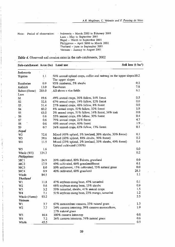
Table 4. Observed soil erosion rates in the sub-catchments, 2002
Sub-catchment Area (ha) Land use Soil loss (t ha")
Mixed (45% upland, 5% lowland, 20% shrubs, 30% forest) 0.1Mixed (60% upland, 10% shrubs, 30% forest) 0.2Mixed (23% upland, 2% lowland, 35% shrubs, 40% forest) 0.4Upland cultivated (100%)
50% annual upland crops, coffee and nutmeg on the upper slopes10.2The upper slopes95% rambutan, 5% shrubs 0.2Rambutan 7.8All above + rice fields 6.1
49% annual crops, 36% fallow, 14% forest 0.567% annual crops, 19% fallow, 12% forest 0.027% annual crops, 48% fallow, 8% forest 0.98% annual crops, 51% fallow, 32% forest 1.92% annual crops, 51% fallow, 14% forest, 34% teak 0.055% annual crops, 6% fallow, 30% forest 0.479% annual crops, 21% forest 4.740% annual crops, 60% forest 1.924% annual crops, 63% fallow, 13% forest 0.1
IndonesiaTegalan 1.1
Rambutan 0.9Kalisidi 13.0Babon (flume) 285.0LaosSI 19.6S2 32.8S3 51.4S4 60.2S5 63.0S6 0.6S7 0.6S8 0.6S9 0.7NepalW2 72.6W3 39.6W4 11.5
W5 1.6Whole (Wl) 124.3PhilippinesMCl 24.9MC2 17.9MC3 8.0MC4 0.9Whole 84.5ThailandWl 11.8W2 9.6W3 3.2W4 7.1Whole (Flume) 93.2VietnamWl 3.7W2 7.7
W3 10.8W4 7.2Whole 45.5
20% cultivated, 80% Falcata, grassland40% cultivated, 60% grassland/forest10% settlement, 15% cultivated, 75% natural grass40% cultivated, 60% grassland
47% soybean-mung bean, 47% tamarind68% soybean-mung bean, 13% shrubs59% tamarind, shrubs, 41% annual crops51% soybean-mung bean, 23% mango, tamarind
67% monoculture cassava, 33% natural grass24% cassava intercrop, 59% cassava monoculture,17% natural grass100% cassava intercrop26% cassava intercrop, 74% natural grass
39
0.00.2
0.00.10.0
28.31.1
0.10.91.51.22.5
1.31.9
0.80.60.5
A Case of Integrated Natural Resource Management Research
In Indonesia, sediment yield was highest in the Tegalan sub-catchment dominated byupland annual crops yielding a soil loss of 20 t ha" in one year of observation. This ispresumably because of minimal soil surface litter and little canopy cover of the catchment(Agus et al., 2002, 2002a). On the other hand, the other sub-catchments (Rambutan andKalisidi) planted to perennials (primarily rambutan), lost only about 1 t ha' of soil during thesame period, yielding most sediment during the middle part of the rainy season (January).
In 2002, there was again a relatively higher erosion rate of 10 t ha:' in the Tegalan subcatchment. However, there was a significant reduction in the erosion rate compared with 2001.This could be attributed to the introduction of the fodder grass to reduce erosion and improvefarmers' income through livestock integration. It should be noted that in 2002, more than 60percent of the area adopted this intervention.
In the Philippines, the smallest sub-catchment (MC4), which has a higher percentage ofcultivated area, gave the highest soil loss of54 t ha'. The lowest soil loss of 0.1 t ha" was fromthe MC1 sub-catchment which has a lower percentage of cultivated land and a larger areacovered with grasses. The MC3 sub-catchment, which has the lowest percentage of cultivatedarea but with 10 percent of settlements, yielded a higher soil loss. The relatively higher soilloss in this sub-catchment may be attributed to erosion from the foot trails and road network(Ilao et al., 2002). Using a simulation model, Ziegler et al. (1999) showed that roads generaterunoff sooner during a rainfall event, and have greater discharge values than other surfaces.Sediment transport was also greater. Footpaths emerged as important sources of acceleratedrunoff from agricultural fields that would otherwise require large amounts of rainfall to producerunoff.
In Vietnam, W1 (predominantly cassava monoculture with some natural grass) producedthe largest soil loss of about 5.2 t ha'. The least was from W4 (predominantly natural grassand cassava intercropping) at 2.0 t ha". The larger soil loss from W1 (primarily cassavamonoculture) compared with W3 (all cassava intercropping) shows the effect of intercroppingon soil losses. At its peak growth, cassava provides only about 47-56 percent soil cover,whereas mixed cropping or intercropping can increase this protective cover (Toan et al.,2002). The effect of natural grass in the sub-catchments on soil losses was also evident.Natural grass enhances infiltration, reduces runoff and runoff velocity, and consequentlyreduces soil loss.
In Laos, the sub-catchment with the smallest proportion of rotating land and with some8 percent of upland rice (SS) gave the highest soil loss of 2.8 t ha" (Phommassack et al., 2002).No erosion was observed in the sub-catchment with the largest proportion of rotating landand about 12 percent forest (S3). In Nepal all sites gave very low soil losses in both years,irrespective of land use (Bhattarai et al., 2002).
In Thailand, the observed soil losses in 2001 and 2002 were not alarming, being less than2 t ha' (RFDILDD, 2002). The increase in soil loss in W3 from 2001 to 2002 was attributed tothe change in land use. In 2001, this sub-catchment had more than 90 percent tamarind andshrubs. Most of the tamarind trees were cut in 2002 and soybean was planted, increasing thearea planted to annual crops from 3 to 41 percent. Another cause of variation in erosion can bethe rainfall characteristics between years. In 2002, total rainfall was lower and more widelydistributed. In 2001, there was a strong rainfall event which accounted for more than 70percent of the total runoff (Janeau et al., 2003).
40
A.R. Maglinao, C. Valentin and F. Penning de Vries
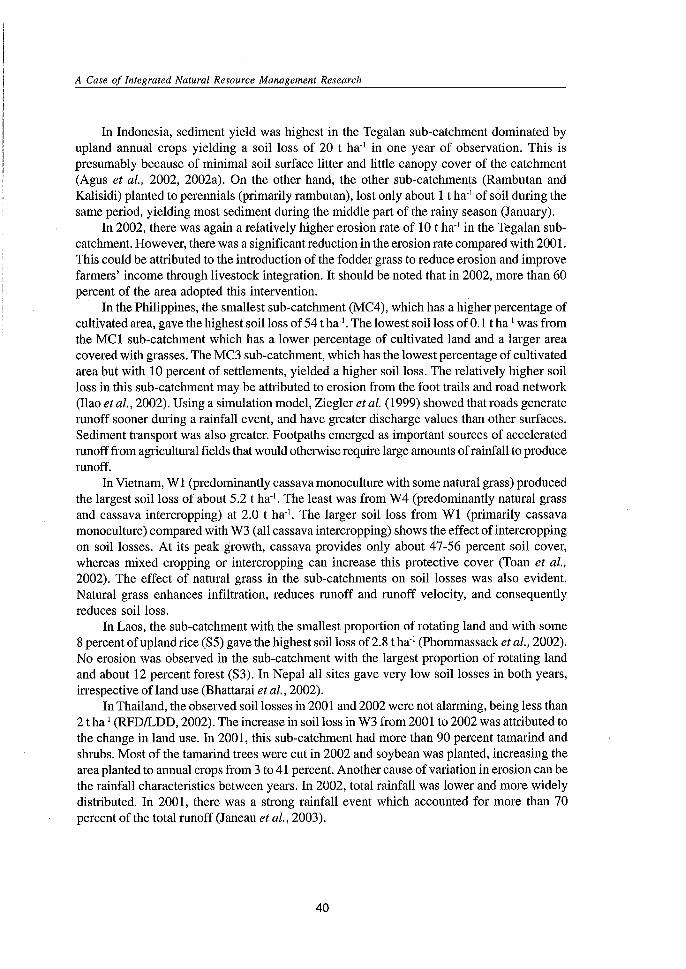
Soil Erosion and Slope
Rainfall simulation studies in Thailand showed that the infiltration rate increased while therunoff coefficient decreased with slope gradient (Janeau et al., 2003a). Moreover, sedimentconcentration and soil detachment decreased sharply with increasing slope indicating thatsoil erosion decreases with slope (Figure 10). These results conflict with the accepted beliefthat more runoff is generated from steeper slopes. It is suggested that for convex landforms,the steep mid-slope zone can act as an infiltration trap for runoff water from the upper gentlerzone. This may have substantial impacts on flow volume generated from small watershedsand on water quality. As similar results are obtained under natural conditions in Laos, it can beconcluded that they are valid for mountain soils with highly stable micro-aggregates. Thedata should encourage more research on the physical processes involved in soil erosion insteep slopes.
Soil detachment as affected by slopegradient
350
•300 ••C)l 250 1st rain: y =-86.90In(x) + 347.68, R 2 =0.84E o 1st rain
2nd rain: y =-187.73In(x) +770.18, R 2 =0.81S!' .2nd rainC 200IDEs:0<ll 150ID'0 ~'0 0en 100 . • •
• • .0o .
50 • •... •0 . o' .....0
0.0 0.1 0.2 0.3 0.4 0.5 0.6 0.7
Slope gradient/m m"
Figure 10. Soil detachment as affected by slope (Janeau et a12003)
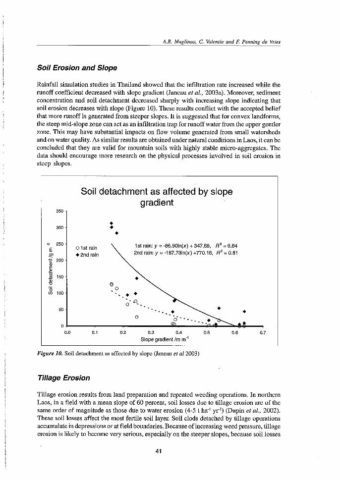
Tillage Erosion
Tillage erosion results from land preparation and repeated weeding operations. In northernLaos, in a field with a mean slope of 60 percent, soil losses due to tillage erosion are of thesame order of magnitude as those due to water erosion (4-5 t ha-l yr") (Dupin et al., 2002).These soil losses affect the most fertile soil layer. Soil clods detached by tillage operationsaccumulate in depressions or at field boundaries. Because of increasing weed pressure, tillageerosion is likely to become very serious, especially on the steeper slopes, because soil losses
41
A Case of Integrated Natural Resource Management Research
from tillage increase with slope (Figure 11). Other factors that affect tillage erosion are weedpressure, which causes an increase in the depth and number of tillage operations, and residuesthat trap aggregates and so reduce soil displacement.
Annual tillage erosion rate in Thailand and Laos
30-.::-
C'Cl25Q)
~.c- 20l:0--Q) 15~l:0 10 -'iij0...Q)
5'0(/)
o -0 20 40 60 80
Slope gradient (%)
y =1.0316J·0276
X
R2=0.97
100
• Contourmoldboardplowing in amung beanfield iriThailand
... Manual tillagein a rice fieldin Laos
• Manual tillagein a Job's tearfield in Laos
120
Figure 11, Tillage erosion as affected by slope
Alternative practices that limit weed infestation and the need for tillage operations needto be developed. Where a short fallow period is still possible, improved fallows of pigeon pea(Cajanus cajan) (or Crotalaria, Leucaena, Gliricidiat sown into the previous crop should betested. This plant, which grows faster and provides more nutrients to' the soil than fallowcomposed ofnatural species, can limit weed proliferation. Two other practices can also limittillage erosion. The first is the no till system with cereals and a cover crop. The field isprepared without burning and without tillage. The cover crop reduces weed growth and themulch provides nutrients. The second practice is contour planting, which hinders themovement of soil downslope, causing it to accumulate immediately above the crop line andassociated weeds and residues. Provided there are sufficient obstacles along the crop rows,contour planting will induce the formation of micro-terraces.
Nutrient Loss and the On-site Cost of Soil Erosion
The on-site effect of soil erosion is generally reflected in a reduction of soil productivitythrough the loss of chemical, physical, and biological fertility. Erosion reduces soil depth,decreases water holding capacity and reduces chemical fertility through nutrient and organic
42
A.R. Maglinao, C. Valentin and F. Penning de Vries
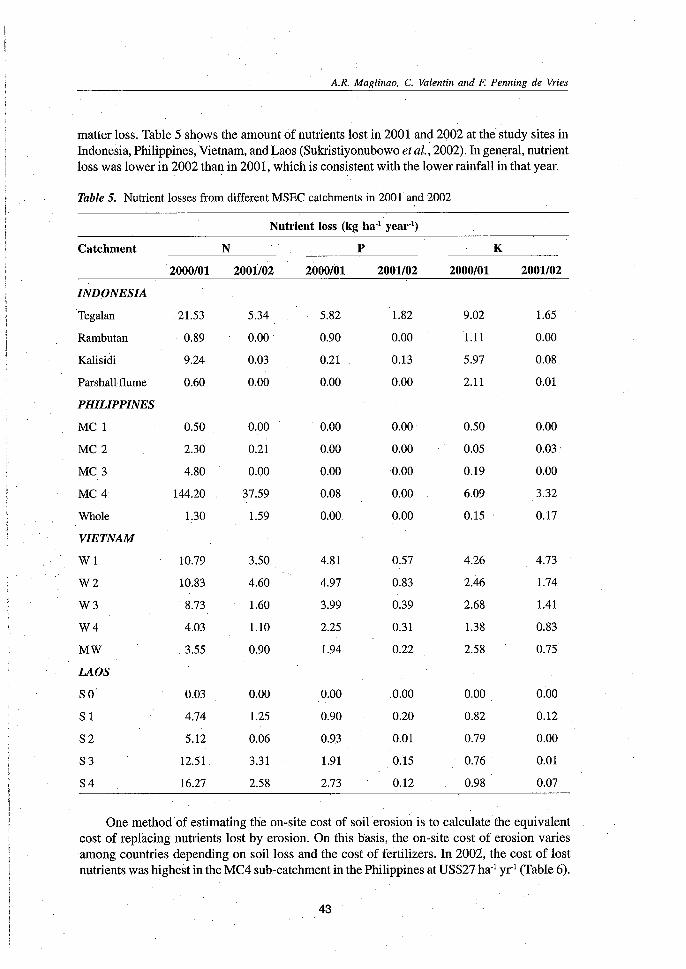
matter loss. Table 5 shows the amount of nutrients lost in 2001 and 2002 at the study sites inIndonesia, Philippines, Vietnam, and Laos (Sukristiyonubowo et al., 2002). In general, nutrientloss was lower in 2002 than in 2001, which is consistent with the lower rainfall in that year.
Table 5. Nutrientlosses from differentMSEC catchments in 2001 and 2002
Nutrient loss (kg ha" year")
Catchment· N P K
2000/01 2001/02 2000/01 2001/02 2000/01 2001102
INDONESIA
Tegalan 21.53 5.34 5.82 1.82 9.02 1.65
Rambutan . 0.89 0.00 . 0.90 0.00 1.11 0.00
Kalisidi 9.24 0.03 0.21 0.13 5.97 0.08
Parshallflume 0.60 0.00 0.00 0.00 2.11 0.01
PHILIPPINES
MC1 0.50 0.00 0.00 0.00 0.50 0.00
MC2 2.30 0.21 0.00 0.00 0.05 0.03'
MC 3 4.80 0.00 0.00 0.00 0.19 0.00
MC4 144.20 37.59 0.08 0.00 6.09 3.32
Whole 1.30 1.59 0.00 0.00 0.15 0.17
VIETNAM
W1 10.79 3.50 4.81 0.57 4.26 4.73
W2 10.83 4.60 4.97 0.83 2.46 1.74
W3 8.73 1.60 3.99 0.39 2.68 1.41
W4 4.03 1.10 2.25 0.31 1.38 0.83
MW 3.55 0.90 1.94 0.22 2.58 0.75
LAOS
SO 0.03 0.00 0.00 0.00 0.00 0.00
SI 4.74 1.25 0.90 0.20 0.82 0;12
S2 5.12 0.06 0.93 0.01 0.79 0.00
S3 12.51 3.31 1.91 0.15 0.76 0.01
S4 16.27 2.58 2.73 0.12 0.98 0.07
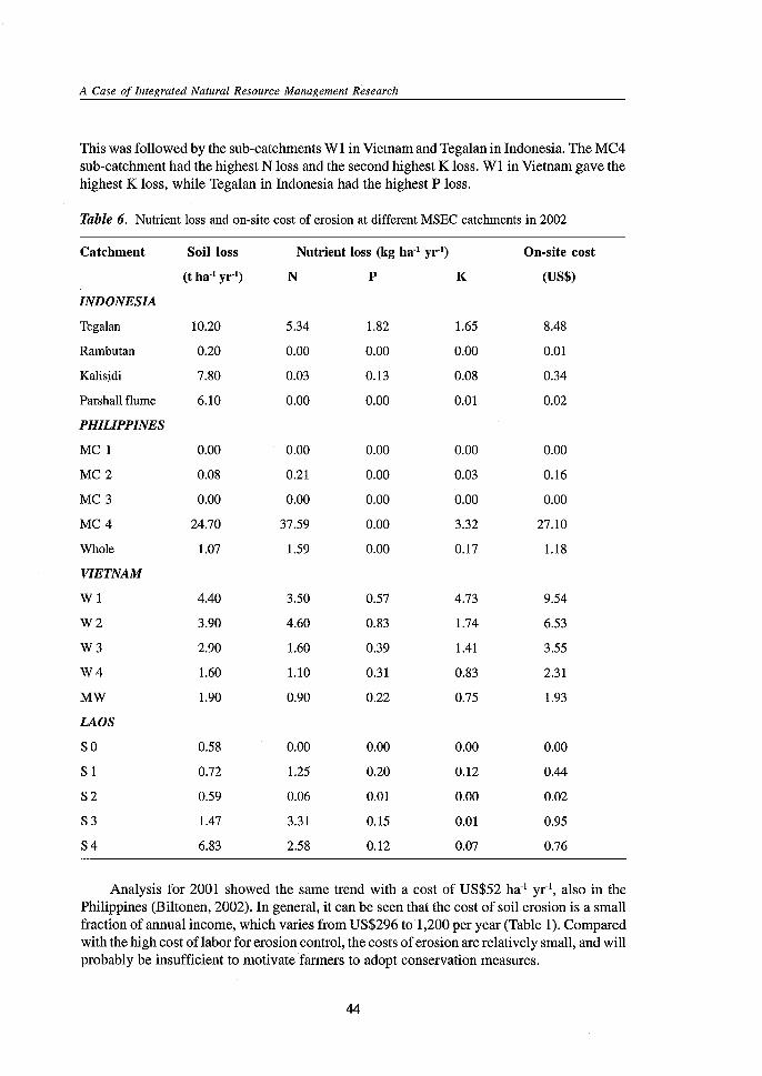
One method of estimating the on-site cost of soil erosion is to calculate the equivalentcost of replacing nutrients lost by erosion. On this basis, the on-site cost of erosion variesamong countries depending on soil loss and the cost of fertilizers. In 2002, the cost of lostnutrients was highest in the MC4 sub-catchment in the Philippines at US$27 ha' yr' (Table 6).
43
A Case of Integrated Natural Resource Management Research
This was followed by the sub-catchments Wl in Vietnam and Tegalan in Indonesia. The MC4sub-catchment had the highest N loss and the second highest K loss. Wl in Vietnam gave thehighest K loss, while Tegalan in Indonesia had the highest P loss.
Table 6. Nutrient loss and on-site cost of erosion at different MSEC catchments in 2002
Catchment Soil loss Nutrient loss (kg ha'! yr") On-site cost
(t ha'! yr') N P K (US$)
INDONESIA
Tega1an 10.20 5.34 1.82 1.65 8048
Rambutan 0.20 0.00 0.00 0.00 0.01
Kalisidi 7.80 0.03 0.13 0.08 0.34
Parshall flume 6.10 0.00 0.00 om 0.02
PHILIPPINES
MC1 0.00 0.00 0.00 0.00 0.00
MC2 0.08 0.21 0.00 0.03 0.16
MC3 0.00 0.00 0.00 0.00 0.00
MC4 24.70 37.59 0.00 3.32 27.10
Whole 1.07 1.59 0.00 0.17 1.18
VIETNAM
W1 4040 3.50 0.57 4.73 9.54
W2 3.90 4.60 0.83 1.74 6.53
W3 2.90 1.60 0.39 1041 3.55
W4 1.60 1.10 0.31 0.83 2.31
MW 1.90 0.90 0.22 0.75 1.93
LAOS
SO 0.58 0.00 0.00 0.00 0.00
SI 0.72 1.25 0.20 0.12 0044
82 0.59 0.06 0.01 0.00 0.02
83 1.47 3.31 0.15 0.01 0.95
84 6.83 2.58 0.12 0.07 0.76
Analysis for 2001 showed the same trend with a cost of US$52 ha' yr', also in thePhilippines (Biltonen, 2002). In general, it can be seen that the cost of soil erosion is a smallfraction of annual income, which varies from US$296 to 1,200 per year (Table 1). Comparedwith the high cost of labor for erosion control, the costs of erosion are relatively small, and willprobably be insufficient to motivate farmers to adopt conservation measures.
44
A.R. Maglinao, C. Valentin and F. Penning de Vries
Off-site Impacts of Soil Erosion
An evaluation of the off-site impacts of soil erosion was conducted by identifying potentialeconomic activities downstream that could be affected by the erosion occurring in the uppercatchments. A simple evaluation of the off-site effect of erosion was carried out at the Philippinesite by estimating the cost of dredging the irrigation canals and diversion of the ManupaliRiver Irrigation System (Ilao et al., 2002). A total of 84685 m" of sediments has been estimatedto have been transported into the system since 1995. Assuming that 0.5 percent comes fromthe Mapawa site, it was estimated to have contributed 423 m" of sediments to the irrigationsystem or an equivalent of US$250 in terms of the cost of dredging.
In Thailand, the sedimentation of the reservoir downstream was also evaluated. Theamount of sediment that had accumulated in the reservoir since the construction of the damwas determined by comparing the topographic map of the site before the operation of thereservoir, and the bathymetric map prepared by conducting a survey before the rainy seasonof June 2002. The maps were prepared using the Surfer program (Bindford and Sloan, 2000).
Siltation in the Mae Thang reservoir at the study site in Thailand showed a 10 percentreduction in its storage volume after seven years of operation (Janeau et al. 2003). The soilerosion rate calculated from the volume of sediments that have accumulated in the reservoirwas 51 t ha-! yr'. At this rate of erosion and sedimentation, the life of the reservoir would notbe more than 70 years (Table 7). The rate may be an overestimation, but the value is close tothat presented by Inthasothi et al. (2000).
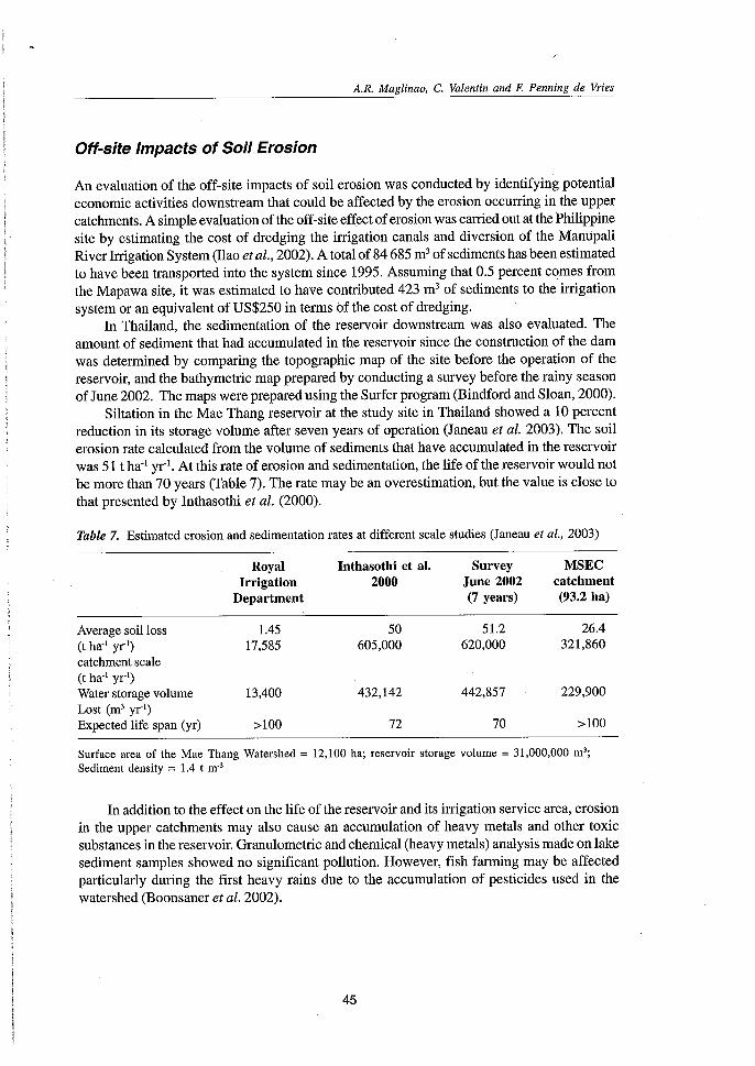
Table 7. Estimated erosion and sedimentation rates at different scale studies (Janeau et al., 2003)
Royal Inthasothi et al. Survey MSECIrrigation 2000 June 2002 catchment
Department (7 years) (93.2 ha)
Average soil loss 1.45 50 51.2 26.4(t ha" yr") 17,585 605,000 620,000 321,860catchment scale(t ha" yr')Water storage volume 13,400 432,142 442,857 229,900Lost (m' yr')Expected life span (yr) >100 72 70 >100
Surface area of the Mae Thang Watershed = 12,100 ha; reservoir storage volume = 31,000,000 m";Sediment density = 1.4 t m?
In addition to the effect on the life of the reservoir and its irrigation service area, erosionin the upper catchments may also cause an accumulation of heavy metals and other toxicsubstances in the reservoir. Granulometric and chemical (heavy metals) analysis made on lakesediment samples showed no significant pollution. However, fish farming may be affectedparticularly during the first heavy rains due to the accumulation of pesticides used in thewatershed (Boonsaner et al. 2002).
45
A Case of Integrated Natural Resource Management Research
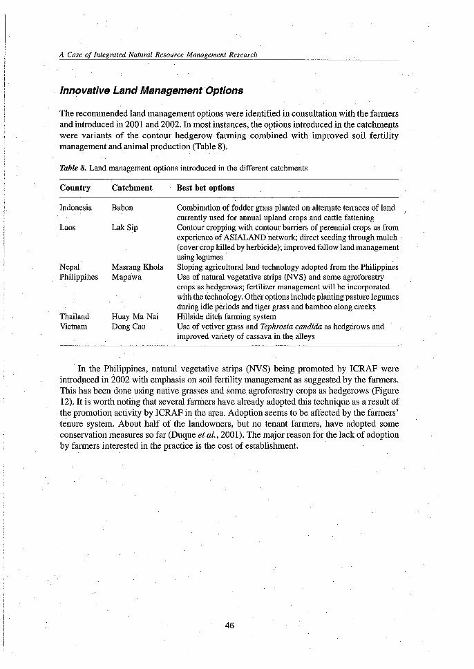
Innovative Land Management Options
The recommended land management options were identified in consultation with the farmersand introduced in 2001 and 2002. In most instances, the options introduced in the catchmentswere variants of the contour hedgerow farming combined with improved soil fertilitymanagement and animal production (Table 8).
Table 8. Land management options introduced in the different catchments
Country
Indonesia
Laos
NepalPhilippines
ThailandVietnam
Catchment
Babon
LakSip
Masrang KholaMapawa
. Huay Ma NaiDong Cao
Best bet options
Combination of fodder grass planted on alternateterraces of land I
currently used for annual upland crops and cattle fatteningContour cropping with contour barriers of perennial crops as fromexperience of ASIALAND network; direct seeding through mulch(cover crop killed by herbicide); improved fallow land managementusing legumes .Sloping agricultural land technology adopted from the PhilippinesUse of natural vegetative strips (NVS) and some agroforestrycrops as hedgerows; fertilizer management will be incorporatedwith the technology. Other options include planting pasture legumesduririg idle periods and tiger grass and bamboo along creeksHillside ditch farming systemUse of vetiver grass and Tephrosia candida as hedgerows andimproved variety of cassava in the alleys
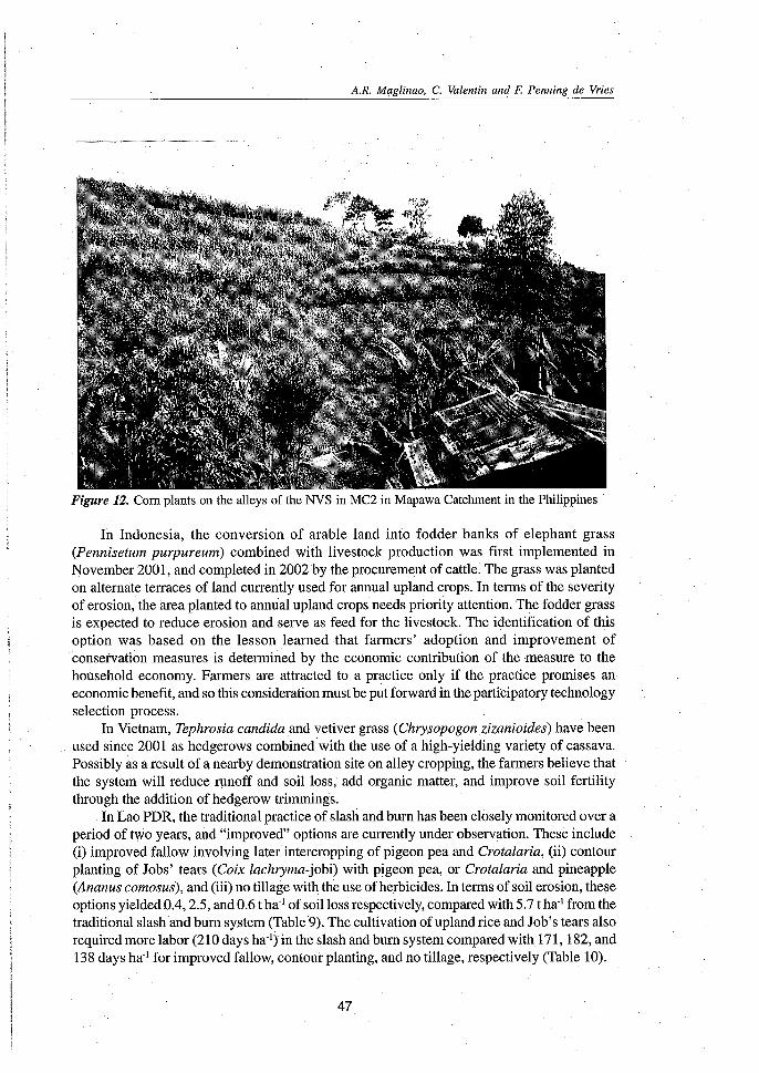
. In the Philippines, natural vegetative strips (NVS) being promoted by ICRAF wereintroduced in 2002 with emphasis on soil fertility management as suggested by the farmers.This has been done using native grasses and someagroforestry crops as hedgerows (Figure12). It is worth noting that several farmers have already adopted this technique as a result Ofthe promotion activity by ICRAFin the area. Adoption seems to be affected by the farmers'tenure system. About half of the landowners, but no tenant farmers, have adopted someconservation measures so far (Duque et al., 2001). The major reason for the hick of adoptionby farmers interested in the practice is the cost of establishment.
46
A.R. Maglinao, C. Valentin and F. Penning de Vries
Figure 12. Corn plants on the alleys of the NVS in MC2 in Mapawa Catchment in the Philippines .
In Indonesia, the conversion of arable land into fodder banks of elephant grass(Pennisetum purpureum) combined with livestock production was first implemented inNovember 2001, and completed in 2002 by the procurement of cattle. The grass was plantedon alternate terraces of land currently used for annual upland crops. In terms of the severityof erosion, the area planted to annual upland crops needs priority attention. The fodder grassis expected to reduce erosion and serve as feed for the livestock. The identification of thisoption was based on the lesson learned that farmers' adoption and improvement ofconservation measures is determined by the economic contribution of thenieasure to thehousehold economy. Farmers are attracted to a practice only if the practice promises aneconomic benefit, and so this consideration must be put forward in the participatory technologyselection process.
In Vietnam, Tephrosia candida and vetiver grass (Chrysopogonzizanioides) have beenused since 2001 as hedgerows combined with the use of a nigh-yielding variety of cassava.Possibly as a result of a nearby demonstration site on alley cropping, the farmers believe thatthe system will reduce runoff and soil loss, add organic matter, and improve soil fertilitythrough the addition of hedgerow trimmings.
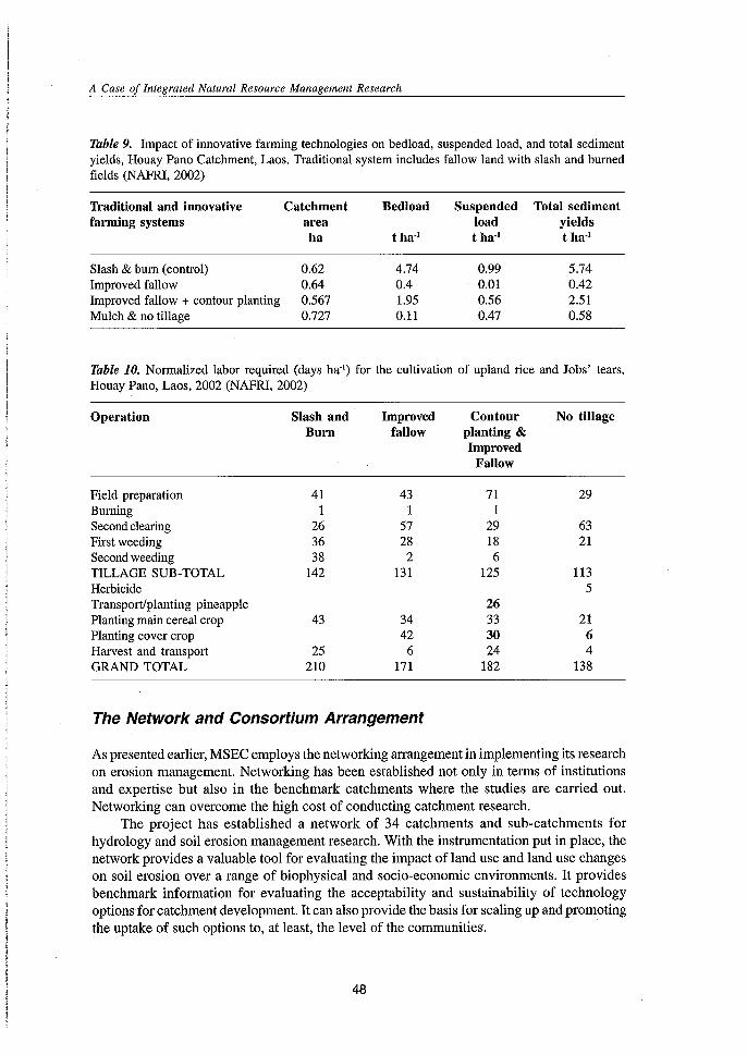
InLao PDR, the traditional practice of slash and burn has been closely monitored over aperiod of two years, and "improved" options are currently under observation. These include(i) improved fallow involving later intercropping of pigeon pea and Crotalaria, (ii) contourplanting of Jobs' tears (Coix lachryma-jobi) with pigeon pea, or Crotalaria and pineapple(Ananus comosus), and (iii) no tillage with the use of herbicides. Interms of soil erosion,theseoptions yielded 004,2.5, and 0.6 t ha:' of soil loss respectively, compared with 5.7 t ha' from thetraditional slash and burn system (Table 9). The cultivation of upland rice and Job's tears alsorequired more labor (210 days ha:') in the slash and burn system compared with171, 182, and138 days ha' for improved fallow, contour planting, and no tillage, respectively (Table 10).
47
A Case of Integrated Natural Resource Management Research
Table 9. Impact of innovative farming technologies on bedload, suspended load, and total sedimentyields, Houay Pano Catchment, Laos. Traditional system includes fallow land with slash and burnedfields (NAFRI, 2002)
Traditional and innovative Catchment Bedload Suspended Total sedimentfarming systems area load yields
ha t ha'} t ha'} t ha'}
Slash & burn (control) 0.62 4.74 0.99 5.74Improved fallow 0.64 0.4 0.01 0.42Improved fallow + contour planting 0.567 1.95 0.56 2.51Mulch & no tillage 0.727 0.11 0.47 0.58
Table 10. Normalized labor required (days ha") for the cultivation of upland rice and Jobs' tears,Houay Pano, Laos, 2002 (NAFRI, 2002)
Operation Slash andBurn
Improvedfallow
Contourplanting &Improved
Fallow
No tillage
Field preparation 41 43Burning 1 1Secondclearing 26 57First weeding 36 28Secondweeding 38 2TILLAGE SUB-TOTAL 142 131HerbicideTransport/planting pineapplePlanting main cereal crop 43 34Planting cover crop 42Harvest and transport 25 6GRAND TOTAL 210 171
The Network and Consortium Arrangement
711
29186
125
26333024
182
29
6321
1135
2164
138
As presented earlier, MSEC employs the networking arrangement in implementing its researchon erosion management. Networking has been established not only in terms of institutionsand expertise but also in the benchmark catchments where the studies are carried out.Networking can overcome the high cost of conducting catchment research.
The project has established a network of 34 catchments and sub-catchments forhydrology and soil erosion management research. With the instrumentation put in place, thenetwork provides a valuable tool for evaluating the impact of land use and land use changeson soil erosion over a range of biophysical and socio-economic environments. It providesbenchmark information for evaluating the acceptability and sustainability of technologyoptions for catchment development. It can also provide the basis for scaling up and promotingthe uptake of such options to, at least, the level of the communities. .
48
A.R. Maglinao, C. Valentin and F. Penning de Vries
An active network of institutions and projects working together to address the problemof soil erosion and land management has been put in place. The network has facilitatedexchange of information and expertise on catchment research and development and developedagreed standards and methodologies for this research. These common approaches will enablemore comparative studies and enhance the potential for rapid advances in knowledge onviable erosion management strategies.
The consortium provides an effective mechanism to organize many activities covering alarge geographical area. It provided venues for exchange of experiences between countries,which contribute their experience to other countries. This network between and amongresearchers, has contributed greatly in developing methodologies by combining experiencesfrom different countries. The network also broadened the view of researchers and enhancedresearcher experience via the visiting of other centers in the network.
With stronger and continuing partnerships among stakeholders, particularly the farmers,it is believed that the network and consortium arrangement will bear fruit in the longer term.IWMI will continue to employ this approach and the promising outputs will further be validatedat different scales of application and expanded to a much wider area for greater impact.
Scaling Up for Greater Impact .
The established network of 34 catchments and sub-catchments for hydrology and soil erosionmanagement research provides a valuable tool for evaluating the impact of land use and landuse changes on soil erosion over a range of biophysical and socioeconomic environments. Itprovides benchmark information for evaluating the acceptability and sustainability oftechnology options for catchment development. It can also provide a basis for scaling up andpromoting the uptake of such options to at least the level of communities.
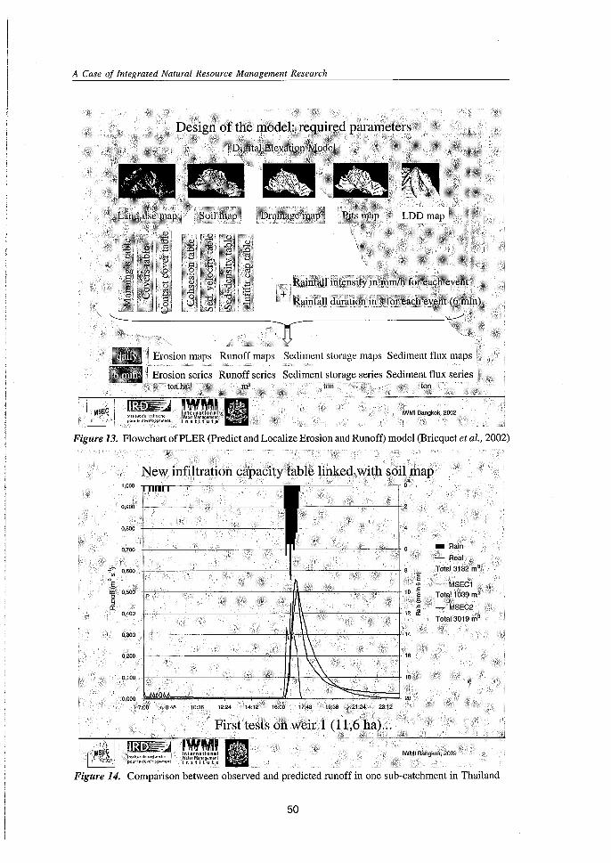
The development of simple models that can be used even by those without muchknowledge of computer or modelling science is one way of addressing this. The PCARES(Predicting Catchment Runoff and Soil Erosion for Sustainability) model was first developedin the Philippines for very steep slope conditions to simulate overland flow and soil erosionfor each erosive rainfall event (Paningbatan et al., 2001). This was further refined by AIT inBangkok, and called the MSEC Version 1 model for dynamic soil erosion (Eiumnoh et al. 2002).The latest version, named PLER (Predict and Localize Erosion and Runoff) model, combinesthe first two versions and has now addressed the problem of fixed runoff coefficients byintegrating soil infiltration capacity in the model (Bricquet et al., 2002). The model is able tosimulate soil erosion and sedimentation patterns within a given catchment «100 ha), provideddata on climate, soil type, topography and land use are fed into the system. Modelling outputsinclude static and dynamic scenarios of the distribution and intensity of erosion, sedimentstorage, and flux (Figures 13 and 14).
IWMI has incorporated impact assessment in its strategic plan and is embedding it in itsresearch project cycle. An initial evaluation of the impact of the project was conducted byanalyzing the benefits derived from its outputs by the collaborating NARES and participatingfarmers. The project may very well serve as a case study for impact assessment, which willsupport the scaling up process.
49
A Case of Integrated Natural Resource Management Research
!MSEC. I..:,"), i lr\~,jt"'! dt t<1(OefCl';tI' ",::,:;:-,: !Xl,Uledht!QPp';mtnt
Figure 13. Flowchart ofPLER (Predict and Localize Erosion and Runoff) model (Bricquet et al., 2002)
New infiltration capacity table linked with soil·rnap
Comparison between observed and predicted runoff in one sub-catchment in Thailand
"'"\jilu!<l<:o,,,(l\('!(i,/lpi>urJodhtl';;i='p""'cnl
10:36 12:24
First tests oh weir 1 (11,6 ha)...
IWMI Bangkok, 2002
50
A.R. Maglinao, C. Valentin and F. Penning de Vries
Next Steps/Challenges
Consultations and meetings with various stakeholders have taken much time, and the start offull-scale implementation of the project has been greatly delayed. A memorandum ofunderstanding (MOD) with the NARES is still needed to formalize the implementation of theproject in the participating countries. It also takes time for some partners to internalize theprinciples of participation, interdisciplinarity, and integration.
The project has a steering committee to provide direction and guidance for the operationof the network or the consortium. However, there is still concern on the effectiveness of thecommittee in providing the expected inputs. The committee meets at most only twice a year,and consequently continuity is usually a problem. The members of the committee are usuallythe national coordinators who are busy with their other responsibilities in their owninstitutions. Several suggestions have been forwarded to strengthen these committees. Smallercluster groups or task forces have been created to look into the more specific issues ofresearch, capacity building, and information dissemination.
Communication between IWMI and the NARES and among the NARES themselves hasbeen a perennial concern. Exchange of information and monitoring is critical in this kind ofresearch, which implements new methodologies and involves a number of partners. Thus,communication between and among partners needs to be further strengthened. Transactioncosts have initially been very significant.
MSEC has been envisaged as a long-term project, and IWMI is committed to outsourcingthe support needed to continue its planned activities. A second phase of the project has beenproposed to develop, adapt, and disseminate appropriate tools and methodologies on how toscale up the application of research results and technology options to larger catchments. Theaim is to better capture the interactions among the on- and off-site users of the land and waterresources, to more effectively resolve competing demands by these users, and to identify anduse impact assessment indicators for project monitoring. With the application of these toolsand methodologies, the promotion and uptake of promising smallholder water and landmanagement systems is expected to be enhanced and to contribute to more sustainable use ofwatershed resources.
IWMI expects that the lessons learned from the case study can be fruitfully used incarrying out research activities in the upper catchments as part of the Global ChallengeProgramme on Water and Food, which IWMI leads. It will also use the experiences of otherrelated program on catchment management. This integrated approach, which considers thebiophysical, socio-economic, policy, and even political environments, could be the bestworkable system to sustain upland development.
51
A Case of Integrated Natural Resource Management Research
References
Agus, F.; Sukukristiyonubowo; Vadari, T.; Hermiyanto; Watung, RL.; and Setiani, C. 2002.Managing soil erosion in Kaligarang catchment of Java, Indonesia. In Integratedcatchment management for land and water conservation and sustainable agriculturalproduction inAsia. Compilation of MSEC papers presented at the IWMI-ICRISAT-ADBJoint Annual Review and Planning Workshop, 10-14 December 2001. Hanoi, Vietnam.CD-ROM.
Agus, F.;Vadari, T.; Sukukristiyonubowo; Valentin, C.; Ilao, R; Due Toan, TB.; and Boosaner,A. 2002a. Effects of catchment size and land management systems on water and sedimentyields: evaluation from several micro catchments in Southeast Asia. Paper presented atthe 7th MSEC Annual Assembly. 2-7 December 2002. Vientiane, Lao PDR.
Bhattarai, S.; Maskey, R.B.; Shrestha, S.; Shrestha, A.B.; Thakur, N.S.; Rai, S.K.; and Dahal,K.P. 2002. MSEC: an innovative approach to sustainable land management in Nepal.Project completion report.
Biltonen, E. 2002. Economic incentives and the adoption of soil conservation practices. InIntegrated catchment management for land and water conservation and sustainableagricultural production in Asia. Compilation of MSEC papers presented at the IWMIICRISAT-ADB Joint Annual Review and Planning Workshop, 10-14 December 2001.Hanoi, Vietnam.CD-ROM.
Bindford, M.W.; and Sloan, IL. 2000. Need to interpolate? Surfer 7.0's Up! Geospatial solutions,November 2000. http://www.goldensoftware.com/surfer7history.shtml
Boonsaner, A; Lorent, c.; and Janeau, J.L. 2002. Off-site effect of erosion: the silting ofMaeThang
reservoir. Paper presented at the T" MSEC Annual Assembly. 2-7 December 2002. Vientiane,LaoPDR
Bricquet, IP.; Migraine., IB.; Boonsaner, A; and Janeau, IL. 2002. MSEC model: a way for upscaling. Paper presented at the T" MSEC Annual Assembly. 2-7 December 2002. Vientiane,LaoPDR
Chaplot, V.;Chanthavongsa, A; Agus, F.;Boonsaner, A; Ilao, R.O.; Toan, TD.; Valentin ,C.;and Silvera, N. 2002. Evaluation of environmental factors and soil erosion in MSECcatchments. Paper presented at the T" MSEC Annual Assembly. 2-7 December 2002.Vientiane,Lao PDR
Craswell, E.T; and Maglinao, AR. 2001. A catchment approach to research on soil erosion inthe marginal uplands of Asia. In Suthipradit, S., C. Kuntha, S. Lorlowhakarn and IRakngan (eds.), Sustainable agriculture: possibility and direction. Proceedings of the2nd Asia-Pacific Conference on Sustainable Agriculture, 18-20 October 1999, Phitsanulok,Thailand. pp. 151-162.
Dupin, B.; Panthahvong, KB; Chanthavongsa, A; and Valentin, C. 2002. Tillage erosion onvery steep slopes in northern Laos. Paper presented at the T" MSEC Annual Assembly.2-7 December 2002. Vientiane, Lao PDR
Duque, C.M.; Tiongco, L.E.; Quita, RS.; Carpina, N.V.;Santos, B.; Ilao, a.o., and De Guzman,M.T. 2001. Management of soil erosion consortium (MSEC): An innovative approach tosustainable land management in the Philippines. Annual report submitted to IWMI,October 2001.
52
A.R. Maglinao, C. Valentin and F. Penning de Vries
Eiumnoh, A, Somnuck, P.; and Sewana, A 2002. A dynamic soil erosion model (MSEC 1): anintegration of mathematical model and PCRaster-GIS. In Integrated catchmentmanagement for land and water conservation and sustainable agricultural productioninAsia. Compilation of MSEC papers presented at the IWMI-ICRISAT-ADB JointAnmialReview and Planning Workshop, 10-14 December 2001. Hanoi, Vietnam. CD-ROM.
FAO. 1986. Strategies, approaches and systems in integrated watershed management. FAO,Rome, Italy. 232 p.
Greenland, DJ.; Bowen, G.; Eswaran, H.; Rhoades, R; and Valentin, C. 1994. Soil, water, andnutrient management research-a new agenda. IBSRAM Position Paper. Bangkok:IBSRAM.
IBSRAM. 1997. Model catchment selectionfor the Management ofSoil Erosion Consortium(MSEC) ofIBSRAM. Report on the Mission to Thailand, Indonesia and the Philippines.Bangkok: IBSRAM.
Ilao, a.o.. Duque, C.M.; Tiongco, L.E.; Villano, M.G.; Carpina, N.V; Santos, E.G.; De Guzman,M.T.; Quita, R.S.; Yadao, RS.; and Mugot, 1.0. 2002. Management of Soil ErosionConsortium (MSEC): An innovative approach to sustainable land management in thePhilippines. Project completion report.
Inthasothi, S.; Jirasuktaveekul, W.; Adirektrakarn, W.; Ratcahdawong, S.; and Boonsaner, A2000. Catchment approach to combating soil erosion in Thailand. In Maglinao, A.R. andR.N. Leslie (eds.), Soil erosion management research in Asian catchments:methodological approaches and initial results - Proceedings of the jI" Management ofSoil Erosion Consortium (MSEC) Assembly. Thailand: IWMI Southeast Asia RegionalOffice. pp. 233-252.
Janeau, lL.; Maglinao, AR; Lorent, c.; Bricquet, lP.; and Boonsaner, A 2003. Off-site effectof soil erosion: A case study of the Mae Thang reservoir in northern Thailand. Paperpresented at the KU-IWMI Seminar on Scientific Cooperation. 26 March 2003. KasetsartUniversity, Bangkok, Thailand.
Janeau, J.L.; Bricquet, lP.; Planchon, 0.; and Valentin, C. 2003a. Soil crusting and infiltrationon very steep slopes in northern Thailand. European Journal ofSoil Science, 54: 1-11.In press.
NAFRI (National Agriculture and Forestry Research Institute). 2002. An innovative approachto sustainable land management in Lao PDR Annual Progress Report (October 2001 toNovember 2002).
Paningbatan, E.P., Jr.; Penning de Vries, F.; Bricquet, lP.; Agus, E; and Virmani, S.M. 2001.Hydrology and soil erosion models for catchment research and management. In Maglinao,AR and RN. Leslie (eds.), Soil erosion management research in Asian catchments:methodological approaches and initial results - Proceedings of the 5'" Management ofSoil Erosion Consortium (MSEC) Assembly. Thailand: IWMI Southeast Asia RegionalOffice. pp. 17-22.
Phommasack, T.; Chanthavongsa, A.; Sihavong, C.; Thonglatsamy, S.; Valentin, C.; De Rouw,A; Marchand, P.; and Chaplot, V 2002. An innovative approach to sustainable landmanagement in Laos. In: Integrated catchment management for land and waterconservation and sustainable agricultural production in Asia. Compilation of MSECpapers presented at the IWMI-ICRISAT-ADB Joint Annual Review and PlanningWorkshop, 10-14 December 2001. Hanoi, Vietnam. CD-ROM.
RFD/LDD. 2002. Catchment approach to combating soil erosion in Thailand. Project completionreport submitted to IWMI.
53
A Case of Integrated Natural Resource Management Research
Sukristiyonubowo; Watung, RL.; Vadari, T.; and Agus, F. 2002. Nutrient loss and on site costof soil erosion under different land use systems. Paper presented at the T" MSEC AnnualAssembly. 2-7 December 2002. Vientiane, Lao PDR
Toan, T.D.; Phien, T.; Phai, D.D.; and Nguyen, L. 2002. Managing soil erosion for sustainableagriculture in Dong Cao catchment. Project completion report submitted to IWMI.
Ziegler,A.D.; Giambelluca,T.W.; and Sutherland,RA. 1999.Field rainfall simulationexperimentsto investigate runoff generation and sediment transport on mountainous roads inNorthern Thailand. Paper presented at the Methodology Workshop on EnvironmentalServices and Land Use Change: Bridging the Gap between Policy and Research inSoutheast Asia. 30 May to 2 June 1999, Chiangmai, Thailand.
54
From Soil Research to Land and-Water Management:Harmonizing People and Nature
IWMI-ADB Project Annual Meeting and Jlh MSEC Assembly
Amado R. Maglinao, Christian Valentin and Frits Penning deVries, editors
Internationalt r Management
Institute
From Soil Research '~O Land and Water Management:Harmonizing People and Nature
Proceedings of the IWMI-ADB Project Annual Meetingand 7th MSEC Assembly
.Organized byNational Agriculture and Forestry Research Institute (NAFRI)
Vientiane, Lao PDRInstitute of Research for Development (IRD)
Vientiane, Lao PDRInternational Water Management Institute (IWMI)
Southeast Asia Regional Office (IWMI-SEA)Bangkok, Thailand
With support fromThe Asian Development Bank (ADB)
Manila, Philippines
Held at Vientiane, Lao PDR2-7 December 2002
Amado R. MaglinaoChristian Valentin and
Frits Penning de Vries, editors
International Water Management Institute (IWMI)Southeast Asia Regional Office
7th Floor, Institute of Food Research and Product Development (IFRPD)Kasetsart University, Jatujak, Bangkok 10903,THAILAND
December 2003
IWMI receives its principal funding from 58 governments, private foundations, and internationaland regional organizations known as the Consultative Group on International AgriculturalResearch (CGIAR)
The editors: Amado R Maglinao is a Senior Researcher and Frits Penning de Vries is theTheme 2 Leader of the International Water Management Institute, Southeast Asia RegionalOffice, Bangkok, Thailand and South Africa Regional Office, Pretoria, South Africa,respectively. Christian Valentin is a Principal Scientist seconded to IWMI from the Institute ofResearch for Development in Vientiane, Lao PDR
IWMI gratefully acknowledges the financial support from the Asian Development Bank(ADB) for the project
Maglinao, A. R; Valentin, c.; Penning de Vries, F.; (Eds). 2003. From soil research to landand water management: Harmonizing people and nature. Proceedings of the IWMI-ADBProject Annual Meeting and 7th Management of Soil Erosion Consortium (MSEC)Assembly, held at Vientiane, Lao PDR, 2-7 December 2002. Bangkok, Thailand: InternationalWater Management Institute. 250 p.
watershed management / soil management / land management / natural resources / soilconservation / erosion / development projects / rain / agricultural research / watermanagement / tillage / hydrology / rainfall-runoff relationships / catchment areas /statistical analysis / Asia / South East Asia / Indonesia / Laos / Nepal/Philippines /Thailand / Vietnam
ISBN - 929090533 6
Copyright © 2003, by IWMI. All rights reserved
Responsibility for the contents of this publication rests with the authors
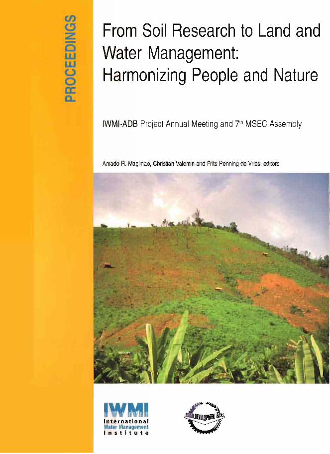
Cover Photograph: Gullies formed on cultivated steep slopes, Houay Pano catchment,Lao PDR, photo. A. de Rouw.
ii