the labrador trough of western labrador and adjoining ...the labrador trough of western labrador and...
TRANSCRIPT
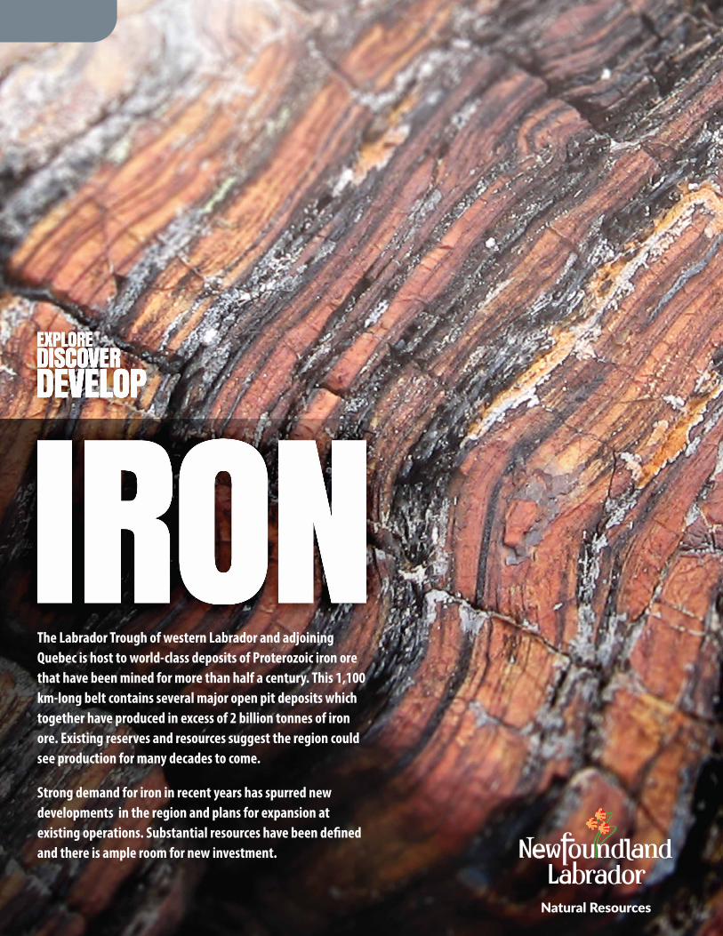
The Labrador Trough of western Labrador and adjoining Quebec is host to world-class deposits of Proterozoic iron ore that have been mined for more than half a century. This 1,100 km-long belt contains several major open pit deposits which together have produced in excess of 2 billion tonnes of iron ore. Existing reserves and resources suggest the region could see production for many decades to come.
Strong demand for iron in recent years has spurred new developments in the region and plans for expansion at existing operations. Substantial resources have been de�ned and there is ample room for new investment.
January 2020
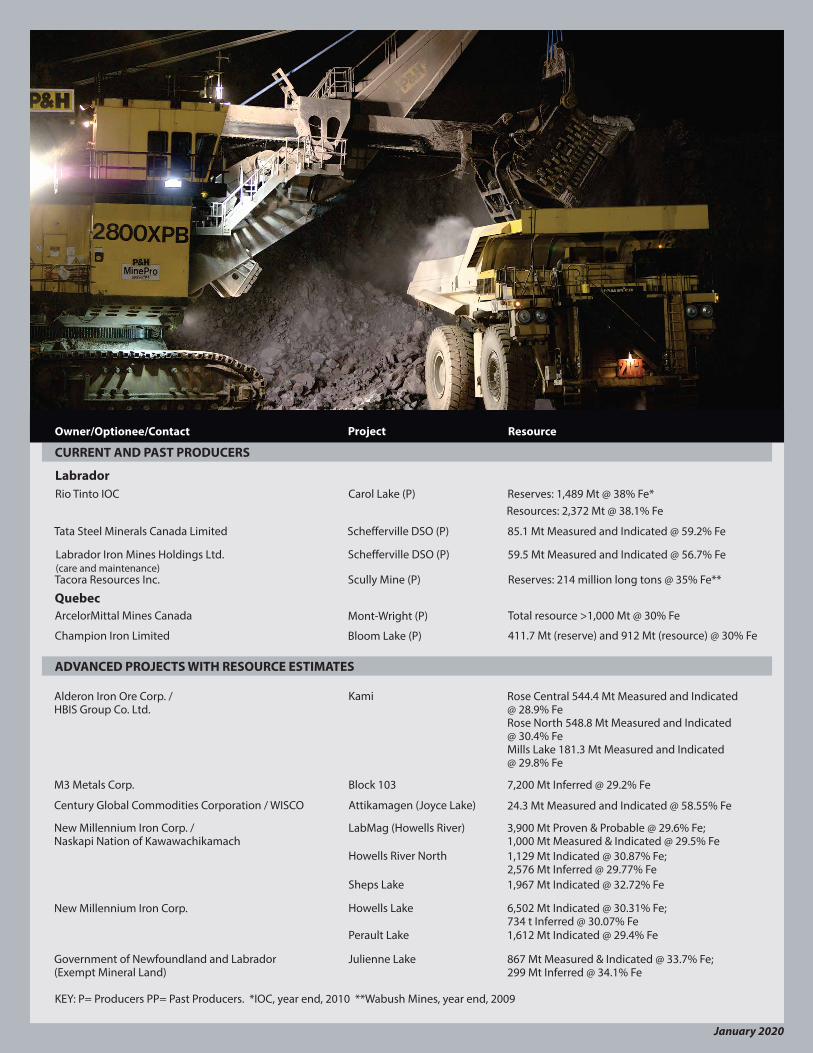
ADVANCED PROJECTS WITH RESOURCE ESTIMATES
CURRENT AND PAST PRODUCERS
Labrador
Quebec
Bloom Lake (P) 411.7 Mt (reserve) and 912 Mt (resource) @ 30% Fe
Total resource >1,000 Mt @ 30% Fe ArcelorMittal Mines Canada Mont-Wright (P)
Champion Iron Limited
Schefferville DSO (P) 85.1 Mt Measured and Indicated @ 59.2% FeTata Steel Minerals Canada Limited
Rio Tinto IOC Carol Lake (P) Reserves: 1,489 Mt @ 38% Fe*Resources: 2,372 Mt @ 38.1% Fe
Scully Mine (P)Tacora Resources Inc. Reserves: 214 million long tons @ 35% Fe**
Labrador Iron Mines Holdings Ltd. (care and maintenance)
Schefferville DSO (P) 59.5 Mt Measured and Indicated @ 56.7% Fe
Owner/Optionee/Contact Project Resource
KEY: P= Producers PP= Past Producers. *IOC, year end, 2010 **Wabush Mines, year end, 2009
Sheps Lake 1,967 Mt Indicated @ 32.72% Fe
Rose Central 544.4 Mt Measured and Indicated@ 28.9% Fe Rose North 548.8 Mt Measured and Indicated@ 30.4% Fe Mills Lake 181.3 Mt Measured and Indicated@ 29.8% Fe
Alderon Iron Ore Corp. / HBIS Group Co. Ltd.
Kami
M3 Metals Corp. Block 103 7,200 Mt Inferred @ 29.2% Fe
Century Global Commodities Corporation / WISCO Attikamagen (Joyce Lake) 24.3 Mt Measured and Indicated @ 58.55% Fe
3,900 Mt Proven & Probable @ 29.6% Fe;1,000 Mt Measured & Indicated @ 29.5% Fe
New Millennium Iron Corp. / Naskapi Nation of Kawawachikamach
LabMag (Howells River)
Howells River North 1,129 Mt Indicated @ 30.87% Fe;2,576 Mt Inferred @ 29.77% Fe
Government of Newfoundland and Labrador (Exempt Mineral Land)
Julienne Lake 867 Mt Measured & Indicated @ 33.7% Fe;299 Mt Inferred @ 34.1% Fe
Howells Lake New Millennium Iron Corp. 6,502 Mt Indicated @ 30.31% Fe;734 t Inferred @ 30.07% Fe
Perault Lake 1,612 Mt Indicated @ 29.4% Fe

Tonalitic orthogneiss and lesser metasedimentary gneiss
ARCHEAN
Rhyolite, ash-�ow tu�, breccia and hypabyssal rhyolite intrusions; volcaniclastic siltstone and sandstone; minor basalt
Orthopyroxene-bearing tonalite to granite plutons
Pillow basalt, basaltic pyroclastic rocks; minor siltstone and greywacke
Alkalic basalt �ows, pyroclastic rocks and local peralkaline felsic volcanic rocks; minor ultrama�c rocks
Ultrama�c sills
Gabbro and leucogabbro sills
Arkosic siltstone and sandstone, locally dolomitic
P2st - Siltstone - shale - greywacke sequences of deep water, turbiditic originP2sts - Schistose equivalent rocks
P2i - Cherty ironstone and underlying quartxiteP2is - Schistose to gneissic equivalent rocks
P2d - Dolomite and chert brecciaP2dm - Equivalent dolomitic marble
Massive to pillowed basalt �ows
P2sh - Shale and sandstone of shallow- to deep-water originP2ss - Equivalent pelitic schist
Arkose and conglomerate
MIDDLE PALEOPROTEROZOIC
Rhyolitic to andesitic volcanic rocks including ash-�ow tu� and agglomerate
Granite, quartz monzonite, granodiorite, syenite and minor quartz diorite
Volcaniclastic sandstone, arkose and conglomerate
Ma�c intrusive suites (gabbronorite, lesser diorite), some metamorphosed at amphibolite to granulite facies
Pelitic, migmatitic metasedimentary gneiss and minor psammitic gneiss at amphibolite to granulite facies
LATE PALEOPROTEROZOIC
Olivine gabbro and metamorphic equivalents, including coronitic varieties
Arkose, quartzite and minor conglomerate
EARLY MESOPROTEROZOIC
LEGEND
CANADA
U.S.A.
U.S.A.
Wabush
LabradorCity
Wabush
LabradorCity
Schefferville
0 20 40
kilometres
MAP AREA(PART OF
LABRADOR TROUGH)
INDEX MAP
km1500
LABRADOR
Producer - - - - - - - - - - - - - - - - - - - - - - - -
Developed prospect - - - - - - - - - - - - - - -
Past-producer, dormant - - - - - - - - - - - -
Past-producer, exhausted - - - - - - - - - - -
All occurrences - - - - - - - - - - - - - - - - - - -
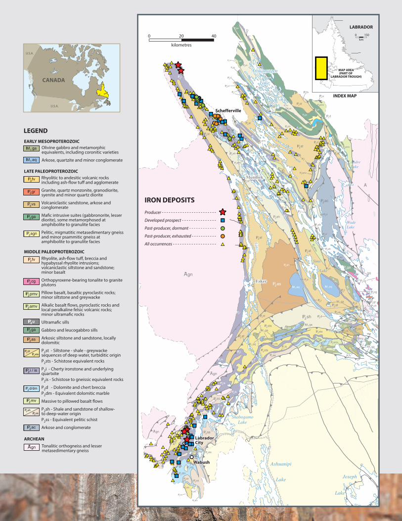
IRON DEPOSITS
The accompanying geological map shows the large number of iron showings, prospects and deposits that occur within the region. The largest of the deposits are summarized in the table, overleaf. The opportunities and potential for future mineral development in this portion of the Labrador Trough are very significant.
The producing and past-producing deposits are primarily oxide-facies
Superior-type iron formation, formed as a chemical sediment in a shallow
marine environment. In the Labrador City mining camp, Proterozoic iron
formation was refolded and metamorphosed during the Grenvillian
orogeny. The resultant metamorphic grades, which are higher than that
elsewhere in the Labrador Trough to the north, allow for easier
bene�ciation because of coarser grain size. The development of major
deposits, such as the Iron Ore Company of Canada’s Carol Project, is the
result in part of hinge-thickening in syncline cores and repetition by folds.
Detailed descriptions of the ores, their origin and their setting are given in
Gross, 1972 (GSC Economic Geology Report 22) and reviewed in Neal, 2000
(Exploration and Mining Geology, volume 9) and Conli�e et al., 2012
(Geological Survey, Mineral Commodity Series #7). Another useful
summary is that prepared by Hatch and Associates (1980) for the
Government of Newfoundland and Labrador.
In general, three types of iron ores are known: high-grade ores (hematite,
goethite, limonite) locally with supergene enrichment (Sche�erville);
weakly metamorphosed magnetite iron formation or taconite (LabMag,
KeMag), and metamorphosed coarse-grained (specularite-magnetite) iron
formation (Carol Lake-Wabush).
In the southern part of the Labrador Trough, two major iron ore mines lie in
close proximity to the Labrador-Quebec border: Iron Ore Company of
Canada (IOC) and ArcelorMittal Mines Canada. Two other mines in this area
recently restarted operations (Scully Mine and Bloom Lake). The IOC
deposits alone have produced in excess of 1.3 billion tonnes of iron ore.
Farther north in the Menihek area, there are two additional operations:
Labrador Iron Mines (care and maintenance) and Tata Steel Minerals
Canada. Each has several deposits of direct shipping ores (DSO) in the area,
some of which were explored and previously mined by IOC.
Also near Menihek, New Millennium/Tata Steel Minerals have outlined two
very large deposits - LabMag and KeMag - of magnetite iron ore (taconite)
in Labrador and Quebec, respectively. Other deposits are shown on
the map.
In the Labrador City-Wabush area, Alderon Iron Ore has partnered with
Hebei Iron and Steel Group to develop its Kami Project. Also, the
Government of Newfoundland and Labrador currently controls the rights
to the Julienne Lake iron ore deposit.
IRON IN LABRADOR
The towns of Labrador City and Wabush, situated within the Labrador
Trough, represent a strategically located provincial gateway
supported by a year-round, air, road and rail transportation network.
Elsewhere, new investments are being made in a deep-water port
facility. The area has a stable, highly skilled and productive workforce
with a strong mining tradition.
QUÉBEC
LABRADOR
0 150
kilometres
LABRADORTROUGH
Quebec Cartier Railw
ay
QN
S&L
Port-Cartier
Sept Îles
Point Noire St. Lawrence River
ATLANTIC OCEAN
Smallwood Reservoir
Churchill FallsTwin Falls
Ross Bay Junction
Churchill FallsTwin Falls
Ross Bay Junction
Churchill FallsGenerating Station
Nain
LabradorCity
Schefferville
WabushBloom Lake
Mont-Wright
Kami
Lac Virot
Block 103
Direct Shipping Ore
Direct Shipping Ore
Labmag
Julienne Lake Iron Horse
Perault Lake Sheps Lake
Howells Lake
Carol Lake
Scully Mine
Joyce Lake
Bloom Lake
Mont-Wright
Kami
Lac Virot
Block 103
Direct Shipping Ore
Direct Shipping Ore
Labmag
Julienne Lake Iron Horse
Perault LakeSheps Lake
Howells Lake
Carol Lake
Scully Mine
Joyce Lake
MinesIron Ore Projects with Resource EstimatesOther Iron Ore ProjectsPort FacilityRail LineHydro LineOther RoadTrans-Labrador Highway
INDEX MAPINDEX MAP
Howells River NorthHowells River North
Goethite BayGoethite Bay
(New Milenium/Naskapi Nation)
(Tata Steel Minerals Canada)
(Labrador Iron Mines Care and maintenance)
(Champion Iron)
(ArcelorMittal Mines)
(First Mining)
(Alderon Iron & HBIS Group)
(Government of NL) (Sokoman Iron)
(New Millennium)(New Millennium/Naskapi Nation)
(Rio Tinto IOC)
(Tacora Resources)
(M3 Metals)
(Century Global & WISCO)
(New Millennium)
(High Tide Resources)
(New Millennium/Naskapi Nation)
Tonalitic orthogneiss and lesser metasedimentary gneiss
ARCHEAN
Rhyolite, ash-�ow tu�, breccia and hypabyssal rhyolite intrusions; volcaniclastic siltstone and sandstone; minor basalt
Orthopyroxene-bearing tonalite to granite plutons
Pillow basalt, basaltic pyroclastic rocks; minor siltstone and greywacke
Alkalic basalt �ows, pyroclastic rocks and local peralkaline felsic volcanic rocks; minor ultrama�c rocks
Ultrama�c sills
Gabbro and leucogabbro sills
Arkosic siltstone and sandstone, locally dolomitic
P2st - Siltstone - shale - greywacke sequences of deep water, turbiditic originP2sts - Schistose equivalent rocks
P2i - Cherty ironstone and underlying quartxiteP2is - Schistose to gneissic equivalent rocks
P2d - Dolomite and chert brecciaP2dm - Equivalent dolomitic marble
Massive to pillowed basalt �ows
P2sh - Shale and sandstone of shallow- to deep-water originP2ss - Equivalent pelitic schist
Arkose and conglomerate
MIDDLE PALEOPROTEROZOIC
Rhyolitic to andesitic volcanic rocks including ash-�ow tu� and agglomerate
Granite, quartz monzonite, granodiorite, syenite and minor quartz diorite
Volcaniclastic sandstone, arkose and conglomerate
Ma�c intrusive suites (gabbronorite, lesser diorite), some metamorphosed at amphibolite to granulite facies
Pelitic, migmatitic metasedimentary gneiss and minor psammitic gneiss at amphibolite to granulite facies
LATE PALEOPROTEROZOIC
Olivine gabbro and metamorphic equivalents, including coronitic varieties
Arkose, quartzite and minor conglomerate
EARLY MESOPROTEROZOIC
LEGEND
CANADA
U.S.A.
U.S.A.
Wabush
LabradorCity
Wabush
LabradorCity
Schefferville
0 20 40
kilometres
MAP AREA(PART OF
LABRADOR TROUGH)
INDEX MAP
km1500
LABRADOR
Producer - - - - - - - - - - - - - - - - - - - - - - - -
Developed prospect - - - - - - - - - - - - - - -
Past-producer, dormant - - - - - - - - - - - -
Past-producer, exhausted - - - - - - - - - - -
All occurrences - - - - - - - - - - - - - - - - - - -
IRON DEPOSITS
The accompanying geological map shows the large number of iron showings, prospects and deposits that occur within the region. The largest of the deposits are summarized in the table, overleaf. The opportunities and potential for future mineral development in this portion of the Labrador Trough are very significant.
The producing and past-producing deposits are primarily oxide-facies
Superior-type iron formation, formed as a chemical sediment in a shallow
marine environment. In the Labrador City mining camp, Proterozoic iron
formation was refolded and metamorphosed during the Grenvillian
orogeny. The resultant metamorphic grades, which are higher than that
elsewhere in the Labrador Trough to the north, allow for easier
bene�ciation because of coarser grain size. The development of major
deposits, such as the Iron Ore Company of Canada’s Carol Project, is the
result in part of hinge-thickening in syncline cores and repetition by folds.
Detailed descriptions of the ores, their origin and their setting are given in
Gross, 1972 (GSC Economic Geology Report 22) and reviewed in Neal, 2000
(Exploration and Mining Geology, volume 9) and Conli�e et al., 2012
(Geological Survey, Mineral Commodity Series #7). Another useful
summary is that prepared by Hatch and Associates (1980) for the
Government of Newfoundland and Labrador.
In general, three types of iron ores are known: high-grade ores (hematite,
goethite, limonite) locally with supergene enrichment (Sche�erville);
weakly metamorphosed magnetite iron formation or taconite (LabMag,
KeMag), and metamorphosed coarse-grained (specularite-magnetite) iron
formation (Carol Lake-Wabush).
In the southern part of the Labrador Trough, two major iron ore mines lie in
close proximity to the Labrador-Quebec border: Iron Ore Company of
Canada (IOC) and ArcelorMittal Mines Canada. Two other mines in this area
recently restarted operations (Scully Mine and Bloom Lake). The IOC
deposits alone have produced in excess of 1.3 billion tonnes of iron ore.
Farther north in the Menihek area, there are two additional operations:
Labrador Iron Mines (care and maintenance) and Tata Steel Minerals
Canada. Each has several deposits of direct shipping ores (DSO) in the area,
some of which were explored and previously mined by IOC.
Also near Menihek, New Millennium/Tata Steel Minerals have outlined two
very large deposits - LabMag and KeMag - of magnetite iron ore (taconite)
in Labrador and Quebec, respectively. Other deposits are shown on
the map.
In the Labrador City-Wabush area, Alderon Iron Ore has partnered with
Hebei Iron and Steel Group to develop its Kami Project. Also, the
Government of Newfoundland and Labrador currently controls the rights
to the Julienne Lake iron ore deposit.
IRON IN LABRADOR
The towns of Labrador City and Wabush, situated within the Labrador
Trough, represent a strategically located provincial gateway
supported by a year-round, air, road and rail transportation network.
Elsewhere, new investments are being made in a deep-water port
facility. The area has a stable, highly skilled and productive workforce
with a strong mining tradition.
QUÉBEC
LABRADOR
0 150
kilometres
LABRADORTROUGH
Quebec Cartier Railw
ay
QN
S&L
Port-Cartier
Sept Îles
Point Noire St. Lawrence River
ATLANTIC OCEAN
Smallwood Reservoir
Churchill FallsTwin Falls
Ross Bay Junction
Churchill FallsTwin Falls
Ross Bay Junction
Churchill FallsGenerating Station
Nain
LabradorCity
Schefferville
WabushBloom Lake
Mont-Wright
Kami
Lac Virot
Block 103
Direct Shipping Ore
Direct Shipping Ore
Labmag
Julienne Lake Iron Horse
Perault Lake Sheps Lake
Howells Lake
Carol Lake
Scully Mine
Joyce Lake
Bloom Lake
Mont-Wright
Kami
Lac Virot
Block 103
Direct Shipping Ore
Direct Shipping Ore
Labmag
Julienne Lake Iron Horse
Perault LakeSheps Lake
Howells Lake
Carol Lake
Scully Mine
Joyce Lake
MinesIron Ore Projects with Resource EstimatesOther Iron Ore ProjectsPort FacilityRail LineHydro LineOther RoadTrans-Labrador Highway
INDEX MAPINDEX MAP
Howells River NorthHowells River North
Goethite BayGoethite Bay
(New Milenium/Naskapi Nation)
(Tata Steel Minerals Canada)
(Labrador Iron Mines Care and maintenance)
(Champion Iron)
(ArcelorMittal Mines)
(First Mining)
(Alderon Iron & HBIS Group)
(Government of NL) (Sokoman Iron)
(New Millennium)(New Millennium/Naskapi Nation)
(Rio Tinto IOC)
(Tacora Resources)
(M3 Metals)
(Century Global & WISCO)
(New Millennium)
(High Tide Resources)
(New Millennium/Naskapi Nation)
The Labrador Trough of western Labrador and adjoining Quebec is host to world-class deposits of Proterozoic iron ore that have been mined for more than half a century. This 1,100 km-long belt contains several major open pit deposits which together have produced in excess of 2 billion tonnes of iron ore. Existing reserves and resources suggest the region could see production for many decades to come.
Strong demand for iron in recent years has spurred new developments in the region and plans for expansion at existing operations. Substantial resources have been de�ned and there is ample room for new investment.
January 2020
ADVANCED PROJECTS WITH RESOURCE ESTIMATES
CURRENT AND PAST PRODUCERS
Labrador
Quebec
Bloom Lake (P) 411.7 Mt (reserve) and 912 Mt (resource) @ 30% Fe
Total resource >1,000 Mt @ 30% Fe ArcelorMittal Mines Canada Mont-Wright (P)
Champion Iron Limited
Schefferville DSO (P) 85.1 Mt Measured and Indicated @ 59.2% FeTata Steel Minerals Canada Limited
Rio Tinto IOC Carol Lake (P) Reserves: 1,489 Mt @ 38% Fe*Resources: 2,372 Mt @ 38.1% Fe
Scully Mine (P)Tacora Resources Inc. Reserves: 214 million long tons @ 35% Fe**
Labrador Iron Mines Holdings Ltd. (care and maintenance)
Schefferville DSO (P) 59.5 Mt Measured and Indicated @ 56.7% Fe
Owner/Optionee/Contact Project Resource
KEY: P= Producers PP= Past Producers. *IOC, year end, 2010 **Wabush Mines, year end, 2009
Sheps Lake 1,967 Mt Indicated @ 32.72% Fe
Rose Central 544.4 Mt Measured and Indicated@ 28.9% Fe Rose North 548.8 Mt Measured and Indicated@ 30.4% Fe Mills Lake 181.3 Mt Measured and Indicated@ 29.8% Fe
Alderon Iron Ore Corp. / HBIS Group Co. Ltd.
Kami
M3 Metals Corp. Block 103 7,200 Mt Inferred @ 29.2% Fe
Century Global Commodities Corporation / WISCO Attikamagen (Joyce Lake) 24.3 Mt Measured and Indicated @ 58.55% Fe
3,900 Mt Proven & Probable @ 29.6% Fe;1,000 Mt Measured & Indicated @ 29.5% Fe
New Millennium Iron Corp. / Naskapi Nation of Kawawachikamach
LabMag (Howells River)
Howells River North 1,129 Mt Indicated @ 30.87% Fe;2,576 Mt Inferred @ 29.77% Fe
Government of Newfoundland and Labrador (Exempt Mineral Land)
Julienne Lake 867 Mt Measured & Indicated @ 33.7% Fe;299 Mt Inferred @ 34.1% Fe
Howells Lake New Millennium Iron Corp. 6,502 Mt Indicated @ 30.31% Fe;734 t Inferred @ 30.07% Fe
Perault Lake 1,612 Mt Indicated @ 29.4% Fe