the hurricane season of 1970
TRANSCRIPT

This article was downloaded by: [New York University]On: 06 December 2014, At: 22:24Publisher: RoutledgeInforma Ltd Registered in England and Wales Registered Number: 1072954 Registeredoffice: Mortimer House, 37-41 Mortimer Street, London W1T 3JH, UK
WeatherwisePublication details, including instructions for authors andsubscription information:http://www.tandfonline.com/loi/vwws20
The Hurricane Season of 1970L. G. Pardue aa National Hurricane Center , Miami, Florida, USAPublished online: 08 Jul 2010.
To cite this article: L. G. Pardue (1971) The Hurricane Season of 1970, Weatherwise, 24:1, 24-51,DOI: 10.1080/00431672.1971.9931509
To link to this article: http://dx.doi.org/10.1080/00431672.1971.9931509
PLEASE SCROLL DOWN FOR ARTICLE
Taylor & Francis makes every effort to ensure the accuracy of all the information (the“Content”) contained in the publications on our platform. However, Taylor & Francis,our agents, and our licensors make no representations or warranties whatsoever as tothe accuracy, completeness, or suitability for any purpose of the Content. Any opinionsand views expressed in this publication are the opinions and views of the authors,and are not the views of or endorsed by Taylor & Francis. The accuracy of the Contentshould not be relied upon and should be independently verified with primary sourcesof information. Taylor and Francis shall not be liable for any losses, actions, claims,proceedings, demands, costs, expenses, damages, and other liabilities whatsoever orhowsoever caused arising directly or indirectly in connection with, in relation to or arisingout of the use of the Content.
This article may be used for research, teaching, and private study purposes. Anysubstantial or systematic reproduction, redistribution, reselling, loan, sub-licensing,systematic supply, or distribution in any form to anyone is expressly forbidden. Terms &Conditions of access and use can be found at http://www.tandfonline.com/page/terms-and-conditions

The Hurricane Season of 1970
L. G. PARDUE, National Hurricane Center,
Miami, Florida
Celia I
HE 1970 hurricane season somewhat re- T sembled 1969 in that each included one major disturbance which more than made up for the otherwise relative quiescence. Re- markable was the fact that every disturbance either entered or approached the Gulf of Mexico. Dorothy dissipated in the Caribbean while headed in that direction. Except for three minor low-latitude perturbations, the Atlantic Ocean area was remarkably quiet.
There was a total of seven named tropical cyclones, but only three became full hurri- canes. This was below the long-term average of eight tropical cyclones and five hurricanes, and considerably below the recent 30-year average ratio of ten and six. . The season began remarkably early when
Alma became only the third May hurricane of record and the second of the 20th century.
Celia, 1970's only hurricane of consequence in the United States, earned fifth place in the all-time list in respect to property dam- age, marking up $454 million. The first four places in this category are held by Camille 1969, Betsy 1965, Diane 1955, and Carol 1954. As is customary, damage is assessed
in current dollars, not adjusted for long-term trends in the value of money. In regard to loss of life, however, the total of 11, all oc- curring in Texas, was negligible when com- pared to the major killers of the past.
Hurricane Celia was noteworthy in other respects also. First, nearly all of the damage was due to wind, not to rising water or flood- ing; second, highest winds were experienced on the left-hand side of the path and in the rear quadrant, contrary to what is expected; and third, the central pressure deepened with perhaps unprecedented rapidity during the fifteen hours before landfall.
The 1970 season was the first during which pictures from satellite ATS3 were available in real time a t National Hurricane Center (NHC), picture No. 1 being received at Miami at 1 1 5 5 EDT on 16 June. So useful did ATS pictures become that reception at NHC from satellite ESSA VIII was soon greatly curtailed. Other advances to be dis- cussed herein include hurricane analogue tech- nique (HURRAN), automated plotting and analysis of data, and a logical decision-ladder procedure.
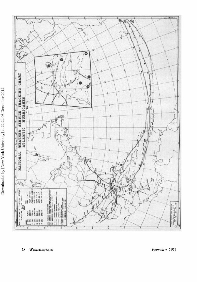
METEOROLOGICAL STATISTICS A N D ESTIMATED DAMAGES A N D CASUALTIES. HURRICANE SE,\SON l'J70
Highest Coast Sustained Lowest Lines Wind Pressure Ilarnagc
Intensity Date Crossed (kt) (nib) (niillioiia) DeaLlib
Hurricane May 17-27 Cuba, Florida 70 993 * 7 Cuba -
1. Alma 2. Becky Trop. Storm July 19-23 Florida 5.5 1003 .5 3. Celia Hurricane July 23-AUK. 5 Cuba, Texas 11.3 945 453.8 5 Cuha. 4. Dorothy Trop. Storm Aug. 13-23 Martinique 6n 996 * 51 West Intlies
Hurricane Sept. 7-13 Mexico 80 967 * * 5. Ella Trop. Storm Sept. 11-17 Texas 60 996
7. Greta Trop. Storm Sept. 15-Oct. 5 - - 48 1005 6. Felice
1 1 Texas
- - -
*Unknown
24 WEATHERWISE February 1971
Dow
nloa
ded
by [
New
Yor
k U
nive
rsity
] at
22:
24 0
6 D
ecem
ber
2014

Windows shattered by Celia leave checkerboard pattern on Guaranty National Bank Tower at Corpus Christi. Photo courtesy of Corpus Christi Caller-Times and NOAA
Public Information Office.
Hurricane Alma Aside from its unusually early occurrence,
Alma offered little out of the ordinary. Drought-breaking rains of five to ten inches occurred over southern Florida, with no at- tendant loss of life and little or no property damage to offset the benefit of the heavy rains. In this respect Alma compared favor- ably with the three most beneficial tropical cyclones on record in the United States.
Ship and land reports foreshadowed a weak depression in the southwestern Caribbean Sea as early as 17 May. A weak center seemed to move inland on the 19th near the Nica- ragua-Honduras border, followed by forma- tion of a new center later that day.
On the 20th, greater development of the storm was presaged by ATS3 pictures showing
increased convection shortly before the arrival of a Navy reconnaissance aircraft. This flight observed the lowest pressure during the dis- turbance, 993mb/29.32”, and the highest winds, 81 mph, about 150 miles east of Swan Island near midday.
Alma was of storm intensity for less than 48 hours, from 2000 EST of the 19th to 1400 EST of the 21st, including the hurricane phase from 0800 to 1400 of the 20th. The highest wind reported at a land station was 63 mph in a squall at Cayman Brac on the 21st. Seven persons died in Cuba.
A blocking Atlantic high was responsible for a westward turn on the 21st; afterwards, Alma moved across western Cuba, northwest- ern Florida, and eastern Virginia, being finally absorbed by a cold front as it was about to show signs of resurgence.
February 1971 WEATHERWISE 25
Dow
nloa
ded
by [
New
Yor
k U
nive
rsity
] at
22:
24 0
6 D
ecem
ber
2014

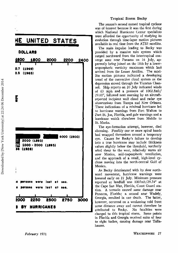
EFFECTS OF MEMORABLE HURRICANES IN I DAMAOE IN MILLIONS
0 200 400 600 800 a000 1200 1400 I I I I I I 1
O U T - * Orar 800 of
8oma sw d
DEATHS CAUSED IN THE UNITED ST4
26 WEATHERWISE February 1971
Dow
nloa
ded
by [
New
Yor
k U
nive
rsity
] at
22:
24 0
6 D
ecem
ber
2014
Tropical Storm Becky The season’s second named tropical cyclone
was of interest because it was the first during which National Hurricane Center specialists were afforded the opportunity of studying its evolution through time-lapse motion pictures available in real time from the ATS3 satellite.
The main impulse leading to Becky was provided by a massive rain system which surged northward from the intertropical con- verge zone near Panama on 16 July, ap- parently being joined on the 18th by a lower- tropospheric vorticity maximum which had arrived from the Lesser Antilles. The satel- lite motion pictures indicated a developing trend of the convective cloud system as the depression moved through the Yucatan Chan- nel. Ship reports on 20 July indicated winds of 63 mph and a pressure of 1002.5mb/ 29.60”, followed next morning by an aircraft- reported incipient wall cloud and radar eye observations from Tampa and New Orleans. These indications of a minimal hurricane led to hurricane warnings from Fort Walton to Port St. Joe, Florida, and gale warnings and a hurricane watch elsewhere from Mobile to St. Marks.
The eye-formation attempt, however, died aborning. Possibly one or more spiral bands had wrapped themselves around a temporary eye. Causes for Becky’s failure to develop into a true hurricane may include thickness values slightly below the threshold, northerly wind shear to the west, relatively warm air over Mexico, mid-tropospheric ventilation, and the approach of a small, high-level cy- clone moving into the north-central Gulf of Mexico.
As Becky deteriorated with its slow north- ward movement, hurricane warnings were lowered early on 22 July. Minimum pressure reported a t landfall was 1007mb/29.74” a t the Cape San Blas, Florida, Coast Guard sta- tion. A tornado caused some damage near Panacea, Florida; a second near Wadely, Georgia, resulted in one death. The latter, however, occurred on a weakening cold front some distance away and cannot therefore be attributed to Becky. No fatalities were charged to this tropical storm. Some points in Florida and Georgia received rains of four to eight inches, causing damage near Talla- hassee.
ME UNITED STATES
’ DOLLARS
f600 1800 2OOO 2200 2 I I I I
0.7 (1969) 0.1 (1963)
LOO0 - 2000 (1893) bc) (1928)
10 poraonr uoro lort o t roo. (I pofaona uoro lort ot. 8.0.
B BY HURRICANES
February 1971 WEATHERWISE 2 7
Dow
nloa
ded
by [
New
Yor
k U
nive
rsity
] at
22:
24 0
6 D
ecem
ber
2014
Dow
nloa
ded
by [
New
Yor
k U
nive
rsity
] at
22:
24 0
6 D
ecem
ber
2014

Hurricane Celia
Hurricane Celia, with an estimated property loss and crop damage of $454 million, was the costliest storm ever to strike the Texas coast. Although ranking meteorologically below sev- eral other Gulf hurricanes in size and in- tensity, Celia dealt a staggering blow to prop- erty in the area around Corpus Christi and Aransas Pass.
Beginning with a report from Dakar on 23 July indicating the passage of a tropical wave, the system that was to become Celia traversed the Atlantic a t the rapid forward speed of 20 to 25 mph. Falling pressures over the southeastern United States eroded the subtropical ridge as the wave moved through the eastern Caribbean on the 28th, resulting in a marked slowing of the disturbance and permitting a closed circulation to become or- ganized between Swan Island and the Cay- man Islands on the 30th. The first bulletin was issued by National Hurricane Center on the 31st, following the location of an eye by airborne radar west of the Isle of Pines.
Now a strong depression, the disturbance moved across extreme western Cuba that night, emerged into the Gulf, and was of- ficially named a t midday on 1 August. Fore- casters at NHC commented on its remarkably consistent speed and direction as it moved toward the Texas coast. Furthermore, there wits unusually good agreement between radar fixes provided by Weather Service Offices a t Brownsville, Victoria, and Galveston and aerial reconnaissance reports provided by the Air Force and Navy.
Hurricane warnings were ordered from Port Arthur to Palacios in Texas a t 1100 CDT on the 2d, with a hurricane watch elsewhere from Morgan City to Corpus Christi. As was the case in Camille (1969), objective forecast techniques consistently predicted a landfall to the right of where it actually oc- curred. Hurricane warnings were gradually adjusted southward during the next 24 hours, being finally ordered for Corpus Christi at 0500 CDT on the 3d.
Another forecast problem concerned intensi- fication, the sudden and explosive deepening during the IS-hour period prior to landfall being unanticipated. At 1600 CDT on the 3d, the tropical cyclone discussion distributed from NHC read as follows (somewhat para-
phrased) : “With Celia on the coast near Port Aransas the question of great concern is diag- nostic, not prognostic. With the mass cir- culation apparently steady, with no synoptic features indicating change, the central pres- sure fell from 988mb/29.18” to 953mb/28.14” in the course of 13 hours. This is without precedent; currently the only explanation is that during the period of steady development beginning 1 August, the inflow was gen- erally from much lower latitudes over very warm tropical water. This trajectory maxi- mizes deep-layer convergence and saturation of the column entering the hurricane circula- tion.” Unfortunately, this change was not completely assessed, so that warnings of stronger winds were somewhat late in coming. Forecasters at Miami, however, concerned by ATS3 evidence of increasing force, reinforced the warnings in direct communications to Corpus Christi during the day.
Celia made landfall a few miles south of Port Aransas Pass shortly after 1600 CDT. At the time the eye was 13 miles in diameter, as confirmed by radar and ground observation. Aransas Pass remained within the eye for 35 minutes.
Corpus Christi was prepared. Residents there heeded fully the warnings, as evidenced by the low ratio of fatalities to damage, 11 casualties compared with $454 million. I t is remarkable that three of the five all-time most destructive hurricanes have occurred on the central and west Gulf coast during the last six years. Much of this damage can be at- tributed to the burgeoning of new construc- tion along our coasts, some perhaps without due regard to the hurricane hazard or to rigid building codes.
The nature of the damage in Celia was unusual. Witnesses said that the steady- state wind was 60-70 mph, accompanied by the usual screaming and whistling associated with such speeds, when suddenly a great gust would explode “like a rocket shell.” These unprecedented high-energy bursts of west winds on the south side of the eye were re- sponsible for nearly all of the damage. Re- sembling the suction spots described by Fujita in the Lubbock tornado, these bursts of per- haps 30-seconds duration, occurred between 1715 and 1730, as evidenced by stopped elec- tric clocks. The bursts resulted in west-east streaks of heavy damage spaced about 1.5
February 1971 WEATHERWISE 29
Dow
nloa
ded
by [
New
Yor
k U
nive
rsity
] at
22:
24 0
6 D
ecem
ber
2014

Celia raised havoc with housing at Corpus Christi Naval Air Station. Caller-Times
photo.
miles apart south of the eye. Between these streaks there was almost no damage, even to the frailest of structures. There was no evi- dence of tornadic action-virtually all of the debris was arrayed from west to east along the path, or in some areas from south to north or from southeast to northwest, as ex- pected if the strongest winds occurred just after the eye passage. There were a few tornados elsewhere, however, but they oc- curred 60 to 200 miles away from the area under discussion and resulted in no fatalities.
Details of structural damage near Corpus Christi almost defy description. Many steel- and-concrete structures suffered heavily; sev- eral tall office buildings lost virtually every window above the second floor. Many mod- ern, expensive frame residences were totally destroyed, but, as stated previously, by wind, not water. Damage to ships and boats was extensive, some vessels coming to rest atop others. Mobile homes were tossed about like confetti, some being stacked atop their neighbors.
In Corpus Christi, nearly 90 percent of the business houses and 70 percent of the residences were damaged. In Port Aransas and Aransas Pass, upwards of one half of the buildings suffered damage.
The lowest officially accepted pressure was 94Smb/27.89" a t Ingleside, where the eye passage took 40 minutes. At Gregory and Taft there were equally long eye passages of 40 minutes. The pressure gradient near the eye amounted to 0.81 of an inch in six miles.
Five stations in the Corpus-Aransas-Taft sector reported gusts in excess of 100 mph, the highest being 161 mph a t the Corpus Christi office of the National Weather Service.
The highest tide report, 9.2 feet (MSL), came from Port Aransas Beach, and as stated earlier, damage to buildings from rising water or pounding sea was light. The rather small size, small rainshield, and rapid movement of Celia precluded any great amounts of pre- cipitation, ranging from about seven inches near Corpus Christi downward to practically none 30 to 40 miles north of the center. General rains of three to four inches accom- panied the storm across South Texas. The relief from a drought probably offset any damage from flooding in the areas of heavier rainfall. Contrary to what happens in most small storms, Celia maintained its strength after landfall for an unusually long period, with thundersquall damage as far inland as Del Rio and Sanderson.
Deaths in Celia included five in Cuba and eleven in Texas. There were, however, nine peripheral drownings in heavy seas along the Florida west coast and panhandle, indirectly related to Celia, situated at that time some 300 miles away.
Tropical Storm Dorothy Dorothy presented three examples of in-
teresting situations: a relatively minor dis- turbance that caused disproportionate loss of life from heavy rains, a disturbance with a pressure as low as 996mb/29.41" that died out in an area climatologically favorable for development, and objective forecasts of a not unusual trend toward an unrealized north- ward turn.
Dorothy was detected by ATS3 satellite photographs on 13 August, moving off the coast of Africa. First aerial reconnaissance was performed on the 19th about 500 miles east of the Windward Islands; these reports, as well as satellite photographs, confirmed the lack of real organization.
Around midday of the 20th, Dorothy moved through the West Indies islands of Martinique, Dominica, and Guadeloupe. By 22 August the storm became even more dis- organized, finally degenerating into a tropical wave.
As Dorothy passed over Martinique, Fort- de-France received more than 12 inches of
30 WEATHERWISE February 1971
Dow
nloa
ded
by [
New
Yor
k U
nive
rsity
] at
22:
24 0
6 D
ecem
ber
2014

rain during a nine-hour period; the highest sustained winds of the storm were around 60 mph at this time. Fifty-one persons were drowned on Martinique and one on Dominica, with extensive damage to crops and roads.
Hurricane Ella Precursory signs of Hurricane Ella were in evidence on the afternoon of 7 September in the northwestern Caribbean Sea. During the 8th, pressures fell in the area, concomitant with the formation of a sharp surface trough from San Andres Island northward to Florida. A tropical depression formed that night near Swan Island.
Moving a little more rapidly, Ella on the 19th passed across the northeast corner of the Yucatan peninsula into the Gulf of Mexico. Steadily increasing in intensity and forward speed, Ella reached hurricane force by early afternoon on 11 September, reports indicating 92 mph. Subsequently, Ella moved westward more slowly, while the central pres- sure decreased to 967mb/28.56" shortly be- fore passing into northeastern Mexico early on the 12th.
On the 11th a hurricane watch was issued for the entire Texas coast, followed by hur- ricane warnings for Brownsville to Port Isabel and gale warnings to Port Aransas. As it became apparent that landfall would be south of Brownsville, warnings emphasized the danger to the Mexican coast.
South Texas received very little effect from the hurricane. Reports from Mexico have been scanty, consisting mainly of newspaper stories telling of a center moving across the coast at La Pesca with winds of 145 mph and destroying 120 homes. Two rivers were re- ported in flood, but no mention was made of casualties or damage.
A useful tool in analysis and forecasting at NHC is the mean shear chart. On this chart the mean pressure-weighted height of the 1,000/600mb layer is subtracted from that of the 600/200mb layer. In the present in- stance, Ella developed in an area of very light vertical shear where the difference in the mean height of the two layers exceeded 5,760 meters, a value which hurricane forecasters have found must be equaled or exceeded if disturbances or depressions are to develop further.
Oil tanks at Ingleside caught fire and lighted sky for days. Caller-Times photo.
Tropical Storm Felice Felice was presaged by an upper-level
trough over the western Bahamas for several days prior to its formation a little north of Nassau on 11 September.
After drifting west-southwestward for two days and passing near Key West, Felice turned more toward the west-northwest, be- gan to deepen, and commenced to move faster. The poorly-formed storm, moving westward, passed a short distance south of the Louisiana coast on the 15th. Radars at New Orleans, Lake Charles, and Galveston located the center a t almost identical points for several hours during this period. Air- craft reconnaissance at this time found the lowest 700mb height, from which a surface pressure of 996mb/29.41" was deduced.
The center of Felice crossed the coast late on the 15th near High Island, Texas, with a pressure of 998mb/29.47" and wind gusts estimated at 70 mph. The highest wind re- corded on the coast was 43 mph at Galveston; the highest tide was three feet at Gilchrest. The storm weakened rapidly thereafter, pass- ing near Houston and Waco, Texas, and Ard- more, Oklahoma. Some local rains of six inches were reported near the track. No damage or casualties were reported.
Tropical Storm Greta Shifting winds at Dakar on 15 September
revealed the passage of a tropical wave, the progenitor of Greta. The wave progressed across the Atlantic at the unusually slow
Febmary 1971 WEATHERWISE 31
Dow
nloa
ded
by [
New
Yor
k U
nive
rsity
] at
22:
24 0
6 D
ecem
ber
2014

forward speed of 12 mph until a strengthen- ing subtropical ridge of high pressure on the 22d caused it to accelerate. Next day satel- lite pictures indicated an increase in cloudi- ness; as the wave coupled with a trough in the upper stratosphere, cyclogenesis was sug- gested. Its nearness to the Virgin Islands and the Leeward Islands prompted the is- suance of public bulletins indicating squally weather in those areas. The heaviest weather, however, veered north of the island chain, setting the stage for an abortive attempt at hurricane formation in the Bahamas.
Greta was christened as a tropical depres- sion on the 26th. The necessary ingredients for intensification appeared to be present that day as Greta approached the warmer waters of the Gulf Stream. Winds began to increase, reaching gale force along the southeastern Florida coast and the Keys. Nevertheless, following a pattern now familiar during the 1970 hurricane season, Greta veered westward and weakened rapidly.
Miami radar echoes on the morning of the 27th gave the first clues of deterioration as the rain bands became disorganized and lost their spiral character. A Navy reconnaissance plane confirmed this trend, finding a central pressure no lower than 1007mb/29.74”, while winds decreased to less than storm force as the vortex approached the lower Keys. Key West experienced the center late that Sunday but Greta’s tale was told-winds were sus- tained only a t 26 mph with gusts to,33 mph. The lowest pressure recorded there was 1007.3mb/29.75”.
After leaving the lower Keys, the remnants of Greta, still maintaining a closed wind cir- culation, followed an anticyclonic trajectory around the periphery of a high pressure sys- tem that had become established in the Gulf. It eventually crossed the Mexican coast near Tampico with a central pressure of 1010mb/ 29.83”.
No deaths or damage were associated with Greta. The lowest pressure was 1005mb/ 29.68”, reported by a reconnaissance plane in the Florida Straits. Maximum winds were 5 5 mph at Tavernier in the upper Keys.
A Tragically Rainy Finale A tropical depression, which moved across
St. Lucia and into the Caribbean Sea on 2 October, brought high winds and rain to
A maximum-minimum thermometer, owned by Paul Taylor of Corpus Christi, contains grass clippings inside the case of the ther- mometer. The outer plastic case was not broken. The grass clippings were partly green at the time Celia occurred. Weather- men who inspected the instrument could not determine how the clippings were drawn inside the case. Photo courtesy of Russell P. Mozeney, Meteorologist in Charge, NWS,
Corpus Christi.
32 WEATHERWISE February 1971
Dow
nloa
ded
by [
New
Yor
k U
nive
rsity
] at
22:
24 0
6 D
ecem
ber
2014
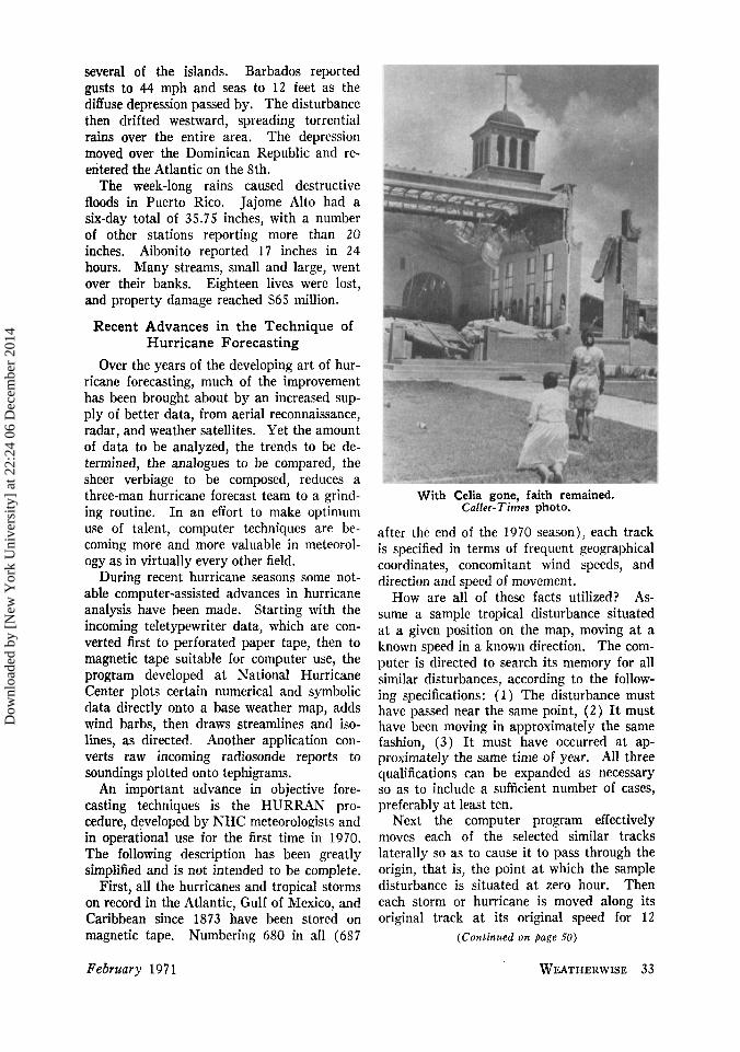
several of the islands. Barbados reported gusts to 44 mph and seas to 12 feet as the diffuse depression passed by. The disturbance then drifted westward, spreading torrential rains over the entire area. The depression moved over the Dominican Republic and re- entered the Atlantic on the 8th.
The week-long rains caused destructive floods in Puerto Rico. Jajome Alto had a six-day total of 35.75 inches, with a number of other stations reporting more than 20 inches. Aibonito reported 17 inches in 24 hours. Many streams, small and large, went over their banks. Eighteen lives were lost, and property damage reached $65 million.
Recent Advances in the Technique of Hurricane Forecasting
Over the years of the developing art of hur- ricane forecasting, much of the improvement has been brought about by an increased sup- ply of better data, from aerial reconnaissance, radar, and weather satellites. Yet the amount of data to be analyzed, the trends to be de- termined, the analogues to be compared, the sheer verbiage to be composed, reduces a three-man hurricane forecast team to a grind- ing routine. In an effort to make optimum use of talent, computer techniques are be- coming more and more valuable in meteorol- ogy as in virtually every other field.
During recent hurricane seasons some not- able computer-assisted advances in hurricane analysis have been made. Starting with the incoming teletypewriter data, which are con- verted first to perforated paper tape, then to magnetic tape suitable for computer use, the program developed a t National Hurricane Center plots certain numerical and symbolic data directly onto a base weather map, adds wind barbs, then draws streamlines and iso- lines, as directed. Another application con- verts raw incoming radiosonde reports to soundings plotted onto tephigrams.
An important advance in objective fore- casting techniques is the HURRAN pro- cedure, developed by NHC meteorologists and in operational use for the first time in 1970. The following description has been greatly simplified and is not intended to be complete.
First, all the hurricanes and tropical storms on record in the Atlantic, Gulf of Mexico, and Caribbean since 1873 have been stored on magnetic tape. Numbering 680 in all (687
With Celia gone, faith remained. Caller-Times photo.
after the end of the 1970 season), each track is specified in terms of frequent geographical coordinates, concomitant wind speeds, and direction and speed of movement.
As- sume a sample tropical disturbance situated a t a given position on the map, moving a t a known speed in a known direction. The com- puter is directed to search its memory for all similar disturbances, according to the follow- ing specifications: (1) The disturbance must have passed near the same point, ( 2 ) It must have been moving in approximately the same fashion, (3) It must have occurred a t ap- proximately the same time of year. All three qualifications can be expanded as necessary so as to include a sufficient number of cases, preferably a t least ten.
Next the computer program effectively moves each of the selected similar tracks laterally so as to cause it to pass through the origin, that is, the point a t which the sample disturbance is situated at zero hour. Then each storm or hurricane is moved along its original track a t its original speed for 12
How are all of these facts utilized?
(Continued on poge 50)
February 1971 WEATHERWISE 33
Dow
nloa
ded
by [
New
Yor
k U
nive
rsity
] at
22:
24 0
6 D
ecem
ber
2014

years that November failed to reach the 40’s. Snowfall was heavy in parts of Manitoba with Churchill on Hudson Bay reporting 28“. Winnipeg had its first blizzard of the season on the 24th.
The weather was generally mild and dull in southern Ontario. At Toronto a total of only 312 hours of bright sunshine over the three autumn months made this the dullest such on record. A lake-effect snowstorm on the 24th left a two-foot snowfall at London, disrupting traffic over a 12-hour period. Mild and damp weather a t Montreal was the re- sult of storms moving northeastward into central Canada from the Great Lakes area bringing a relatively warm southerly flow over southern Quebec for a greater portion of the time than normal.
The Maritime Provinces recorded excellent weather with no severe storms, above normal duration of sunshine, and slightly warmer than normal temperatures. In Newfound- land, however, the generally fine and mild weather of the first two weeks was replaced with much colder temperatures and sub- stantial snowfalls during the latter half of the month.
A temperature of -49“ a t Old Crow in northern Yukon Territory was the coldest in Canada during November, although several stations in the Mackenzie Valley and on the Arctic Islands reported minima of -44”. The coldest location was Eureka with a mean of - 2 2 ” . Snowfall was heavy on the east coast of Baffin Land where Cape Dyer re- ported a fall of 66”, and 33” remained on the ground at the end of the month.
(Courtesy Canadian Meteorological Service)
Hurricanes (Continued from page 33)
hours. The resulting 12-hour locations are analyzed and statistical techniques used to determine a series of probability ellipses. These are elliptical envelopes that can be specified to contain, for example, one-fourth, one-half, three-fourths, or any other fraction of the 12-hour positions. Let us consider only the 50% ellipse, that is, the envelope that encloses one-half of the cases, the other half lying outside. The process is repeated from the same origin to yield 24-hour, 48-hour, and 72-hour ellipses.
This process is begun afresh after each six
hours of real time as an actual disturbance moves along its track, each six-hourly set of computations being independent of all earlier ones. The computer processing, including the curve plotting, requires about five min- utes,
The moment of truth arrives just after the 48-hour, 50% probability ellipse crosses the coastline. Common tangents are then drawn between that ellipse and the corresponding 24-hour ellipse; the sector of the coastline thus intercepted is the basis for a hurricane watch, the preliminary to a hurricane warn- ing provided that the disturbance is forecast to be of hurricane intensity at landfall. This procedure, like all other objective techniques, can be overridden by the responsible hurricane specialist, if he can establish sufficient reason for a differing viewpoint.
Another development in the nascent stage concerns the logical processes involved in de- cision making. Dr. R. H. Simpson, Director, National Hurricane Center, has said, “No weather prediction is ever made by a fore- caster in which the consequences of error in the movement or the development of a pres- sure system are so appalling as in hurricane forecasting, . . . Moreover, the price of pre- paring for a severe hurricane is high and there is an economic constraint on the degree to which warnings can be extended to insure against the frailties of the forecast, . . , These frailties emphasize the need for systematic decision procedures which in the face of in- exact computations and uncertain develop- ments will identify the course of least regret in predictions.”
A full discussion of the principles of ra- tional decision making lies beyond the purview of the present article, but the processes may be suggested briefly along with an outline of procedure.
The first step is the construction of the HURRAN track, previously referred to, with the successive 50%-probability ellipses. Ad- justments to this track are made in terms of the indications derived from other predictive techniques. Mathematical and logical com- parison is made algorithmically in a stepwise fashion, as on a brachiated ladder, consider- ing whether results of SANBAR * predictions
* “SANBAR” and “NHC67” are abbreviated iden- tifications for “Sanders barotropic” and “National Hurricane Center 1967” objective forecast schemes.
50 WEATHERWISE February 1971
Dow
nloa
ded
by [
New
Yor
k U
nive
rsity
] at
22:
24 0
6 D
ecem
ber
2014
and NHC67 * predictions are consistent with those of HURRAN. Adjustments are also made in terms of baroclinicity and continuity, resulting eventually in a track of "least re- gret" with respect to population concentra- tion.
References Hope, John R., and Charles J. Neumann. An op-
erational technique for relating the movement of existing tropical cyclones to past tracks. M o n . W e a . Rev. 98-12 (Dec. 1970) 925-933.
Sugg, A . L. Beneficial aspects of the tropical cyclone. J , A p p l . Meteor. 7-1 (Feb. 1968) 3 9 4 5 .
__ and L. G. Pardue. The hurricane season of 1969. Weatherwise. 23-1 (Feh. 1970) 12-17, 31.
-, L. G . Pardue, and R. L. Carrodus. Memorable Hurricanes of the United States since 1873. ESSA Technical Memorandum WBTM SR-42. Southern Region Headquarters, Fort Worth, Texas. (Revised edition, in press).
The Decision Process in Hurricane Forecasting. NOAA Technical Memorandum
Fujita, Tetsuya T. The Lubbock tornadoes: A study of suction spots. Weatherwise . 23-4 (August 1970) 160-173.
Simpson, R. H.
NWS-SR-53.
Snow (Cont inued f rom Page 23)
Jackson Hole, Wyoming, reduced from 32" on the 1st to nothing on the 19th. Yellowstone Park Hdq. was bare all month.
In Oregon, Crater Lake saw the pack melt from 107" to 54" on the 31st. Depths a t Rainier Paradise in Washington settled from 175" to 123" during the month of May. Stampede Pass was down to 19.6'' and Stevens Pass to 55" by the end of May. JUNE 1970-California reported no snow except on the highest mountain peaks. In Oregon, Crater Lake reduced from 51" on the 1st to a trace by the 22d. In Washing- ton Rainier dropped from 121" to 12" on the 30th. Stampede Pass was bare as early as 9 June.
In Utah, the snow melt season reduced Park City Summit House (9,270') from 20" to zero on the 6th. And Berthoud Pass back in Colorado was bare by the 18th of June.
Circulation (Conttnued from page 11)
southwesterly flow the West warmed con- siderably and was very wet. Only the north- ern Plains remained cooler than normal while temperatures in parts of the Great Basin and the central Rocky Mountains were as much as 6" above normal. Precipitation was more than four times normal in parts of California with some northern areas exceeding 8 inches. Most migratory storms in November moved across the northern half of the country where precipitation was generally heavier than nor- mal. To the south amounts were mostly less than one-half normal. Jacksonville, Fla., with only a trace of rain, had its driest No- vember of record. In addition to drying the South, progression of the Great Plains trough cooled the Southeast to below normal, as much as a -6" departure in the Florida Pan- handle. A highlight of November was the sharp cold spell that moved from the north- ern Rockies on the 22d across Florida on the 24th, bringing record low November tempera- tures to some southeastern cities on the 25th.
The 1970 hurricane season was much less active than that of 1969. Only seven tropical cyclones were observed in 1970 with three reaching hurricane intensity. This compares with the corresponding figures for the 1969 season of 13 and 10. Despite this difference in activity, the average circulation for fall 1970 (fig. 4 ) seemed little different from that of fall 1969.' During both years the mid- latitude westerlies over the Atlantic were dis- placed north of normal and the sub-tropical easterlies aloft and at sea level were stronger than normal, conditions usually associated with an active hurricane season. Exaniina- tion of the monthly mean circulation and sea surface temperature anomaly charts offer no apparent explanation for this marked differ- ence in tropical activity.
Reference 1 4ndrews, J F The Circulation and Weather of
1969 Weatherwise . 23-1 (Feb 1970), 11
February 197 I WEATHERWISE 5 1
Dow
nloa
ded
by [
New
Yor
k U
nive
rsity
] at
22:
24 0
6 D
ecem
ber
2014